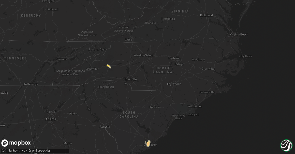
Hail Map in North Carolina on June 26, 2013
Get this storm
June 26 map
$229
one time, instant access
Download today. No call, no setup
Keep the $229
Bought the map and want the full workflow? Apply the entire $229 to a subscription within 7 days. None of it is wasted.
Every map, not just this one
This buys you this map. Subscription and you get every map we run, in the markets you choose from a few cities to whole states to nationwide. Plus real-time alerts the moment a storm fires.
Contact data
Name, contact info, occupancy, even credit band for addresses in the footprint. You go from where it hit to who to call.
Become the source they trust
Unlimited branding weather history reports on demand. You already have the documented answer ready for the property owner, and you are the one who showed up with it.
Property data and RoofTrace estimates
Pull up any address you have got, its value and the exact code rules for that jurisdiction, straight from One Click Code. Then RoofTrace estimates the squares, pitch, and roof value, priced the way you price.
Storm reports in North Carolina
North Carolina
| Date | Description |
|---|---|
| 06/26/20136:44 PM CDT | Trees down in cameron |
| 06/26/20136:44 PM CDT | Multiple trees down around southern pines |
| 06/26/20135:45 PM CDT | One tree was reported donw along st. Martin road near hartsell road. |
| 06/26/20135:45 PM CDT | One tree was reported down along running creek church road near bethel church road. |
| 06/26/20135:35 PM CDT | A couple trees blown down on nance road. |
| 06/26/20135:35 PM CDT | One tree was reported down along gold hill road near finger road. |
| 06/26/20135:00 PM CDT | Powerlines down on the 1400 block of oxford road |
| 06/26/20135:00 PM CDT | 1 tree down on a residence no injuries |
| 06/26/20134:55 PM CDT | 1 tree down on becks church road near i-85 mile marker 93 |
| 06/26/20134:52 PM CDT | 1 tree down on flat river church road at lacy wilkerson road in roxboro |
| 06/26/20134:48 PM CDT | 1 tree down on pinetop road at odell owen road |
| 06/26/20134:39 PM CDT | 2 trees down on hwy 150 near old hwy 64 |
| 06/26/20134:30 PM CDT | Multiple trees and power lines down on markland road and hwy 801 near advance |
| 06/26/20134:06 PM CDT | Multiple trees down in downtown winston salem |
| 06/26/20134:05 PM CDT | A local report indicates 1.00 inch wind near STATESVILLE |
| 06/26/20133:45 PM CDT | Quarter size hail reported on stadium drive |
| 06/26/20133:37 PM CDT | Several trees/wires down. One tree on a car on rhodes road. |
| 06/26/20133:24 PM CDT | Tree down |
| 06/26/20133:20 PM CDT | Trees and power lines down in vale. One tree fell on a home. |
| 06/26/20133:20 PM CDT | Many trees felled from thunderstorm winds in a wooded area about 100 yards long. |
| 06/26/20133:17 PM CDT | Several large trees down on 44th ave drive nw. Pea size hail. |
| 06/26/20133:16 PM CDT | Tree down |
| 06/26/20133:10 PM CDT | Trees down at intersection of wilkies grove rd and claude brittain rds |
| 06/26/20133:03 PM CDT | Several trees reported down south of danbury. |
| 06/26/20133:01 PM CDT | Trees blown down cullasaja gorge |
| 06/26/20132:57 PM CDT | Trees down vicinity will hudson rd |
| 06/26/20132:57 PM CDT | Trees down on wards gap rd |
| 06/26/20132:30 PM CDT | Trees and power lines down at the intersection of highway 70 and snow hill rd |
| 06/26/20132:30 PM CDT | Ping pong hail observed on snow hill church rd |
| 06/26/20132:27 PM CDT | Trees down in dobson |
| 06/26/20132:08 PM CDT | Tree fell on a house on reeves mill road |
| 06/26/20132:15 AM CDT | Several trees down on paint rock road. |
| 06/25/20138:55 PM CDT | Trees and limbs down on sam potts rd about 1 mile west of hallsboro rd. |
| 06/25/20138:05 PM CDT | Numerous trees down and power outages across the city. |
| 06/25/20137:55 PM CDT | 1 tree down at elk and cameron road |
| 06/25/20137:52 PM CDT | 1 tree down at cameron road and south main street |
| 06/25/20137:48 PM CDT | 1 tree down on lake upchurch road |
| 06/25/20137:40 PM CDT | Downed trees hwy 71. |
| 06/25/20137:12 PM CDT | Power lines were reported down along freeman mill road in hamlet. |
| 06/25/20137:05 PM CDT | One tree was reported down on a house on gore drive and west franklin street. |
| 06/25/20137:00 PM CDT | Several trees down at hilltop rd and edinburgh rd intersection. |
All States Impacted by Hail Map on June 26, 2013
Cities Impacted by Hail Map on June 26, 2013
- Darien, GA
- Townsend, GA
- Mayfield, KY
- Sandoval, IL
- Odin, IL
- Kell, IL
- Centralia, IL
- Salem, IL
- North Charleston, SC
- Johns Island, SC
- Charleston, SC
- Hanahan, SC
- Ravenel, SC
- Nebo, NC
- Morganton, NC
- Webster, WI
- Siren, WI
- Ramsey, IN
- Crandall, IN
- Depauw, IN
- New Salisbury, IN
- Corydon, IN
- Wing, ND
- Perryville, MO
- Saint Mary, MO
- Fredericksburg, VA
- Verdigre, NE
- Winnetoon, NE
- Orchard, NE
- Sapelo Island, GA
- Wadmalaw Island, SC
- Charleston Afb, SC
- Sedalia, KY
- Wingo, KY
- Palmersville, TN
- Fulton, KY
- Cottage Grove, TN
- Paris, TN
- Dukedom, TN
- Dresden, TN
- McKenzie, TN
- Cedar Hill, MO
- House Springs, MO
- Hillsboro, MO
- Hardinsburg, IN
- Marengo, IN
- Paoli, IN
- Milltown, IN
- English, IN
- Iuka, IL
- Alma, IL
- Patoka, IL
- Linden, VA
- Front Royal, VA
- Texico, IL
- Vincennes, IN
- Lawrenceville, IL
- Saint Francisville, IL
- Dundas, IL
- Olney, IL
- Willow Hill, IL
- Sumner, IL
- Claremont, IL
- West Liberty, IL
- Bridgeport, IL
- Mizpah, MN
- Northome, MN
- Kelliher, MN
- Wirt, MN
- Max, MN


