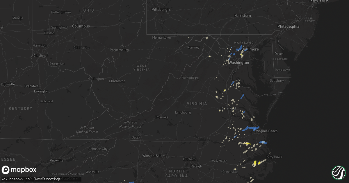
Hail Map in Virginia on June 22, 2020
Get this storm
June 22 map
$229
one time, instant access
Download today. No call, no setup
Keep the $229
Bought the map and want the full workflow? Apply the entire $229 to a subscription within 7 days. None of it is wasted.
Every map, not just this one
This buys you this map. Subscription and you get every map we run, in the markets you choose from a few cities to whole states to nationwide. Plus real-time alerts the moment a storm fires.
Contact data
Name, contact info, occupancy, even credit band for addresses in the footprint. You go from where it hit to who to call.
Become the source they trust
Unlimited branding weather history reports on demand. You already have the documented answer ready for the property owner, and you are the one who showed up with it.
Property data and RoofTrace estimates
Pull up any address you have got, its value and the exact code rules for that jurisdiction, straight from One Click Code. Then RoofTrace estimates the squares, pitch, and roof value, priced the way you price.
Storm reports in Virginia
Virginia
| Date | Description |
|---|---|
| 06/22/20205:00 PM CDT | Tree down into a structure on east main street. |
| 06/22/20204:55 PM CDT | Numerous large trees down near sudley springs and catharpin. |
| 06/22/20204:38 PM CDT | Tree down on us-50 john mosby highway near lenah farm lane. |
| 06/22/20204:30 PM CDT | Numerous trees down between boyce and berryville. |
| 06/22/20204:25 PM CDT | Several trees down in central fauquier county. |
| 06/22/20204:20 PM CDT | About half a dozen trees down on beverly ford road near saint james church road. |
| 06/22/20204:07 PM CDT | Roof torn off barn and numerous trees down. Fencing blown down. |
| 06/22/20203:35 PM CDT | Tree on a home. |
| 06/22/20203:28 PM CDT | Tree down blocking lafayete blvd. |
| 06/22/20203:25 PM CDT | Mesonet station xodu lafayette river. |
| 06/22/20203:15 PM CDT | Delayed report of several large trees snapped along wellford lane near ware neck. Time estimated from radar. |
| 06/22/20203:05 PM CDT | Trees down across western richmond county. |
| 06/22/20203:04 PM CDT | Downed tree near dahlgren rd and indiantown rd |
| 06/22/20203:03 PM CDT | Downed tree near port conway rd and emerald dr |
| 06/22/20203:00 PM CDT | Tree damage in the sterling area. |
| 06/22/20202:52 PM CDT | Downed tree near kings highway and bloomsbury rd |
| 06/22/20202:52 PM CDT | Downed tree near lambs creek church rd and red gate lane |
| 06/22/20202:50 PM CDT | Trees down. |
| 06/22/20202:40 PM CDT | Tree down on steeplechase drive. |
| 06/22/20202:40 PM CDT | Downed tree near port conway rd and emerald dr |
| 06/22/20202:22 PM CDT | Numerous trees and power lines down in ivor and surrounding area. |
| 06/22/20201:56 PM CDT | Downed trees on marye rd near stanfield rd |
| 06/22/20201:50 PM CDT | Trees reported down across potions of western richmond and in henrico. |
| 06/22/20201:50 PM CDT | Multiple downed trees and power lines at park ave/shenandoah st in malvern section of richmond. Time is radar estimated. |
| 06/22/20201:45 PM CDT | Gas station canopy blown over at the 711 at the intersection of highway 60 and robious rd. |
| 06/22/20201:34 PM CDT | Trees and power lines down along cool springs rd. |
| 06/22/20201:30 PM CDT | Trees down along route 40 near route 35. |
| 06/22/202012:58 AM CDT | At 558 PM EDT, a severe thunderstorm was located near Harpers Ferry, or near Charles Town, moving east at 15 mph. HAZARD...60 mph wind gusts and quarter size hail. SOURCE...Radar indicated. IMPACT...Damaging winds will cause some trees and large branches to fall. This could injure those outdoors, as well as damage homes and vehicles. Roadways may become blocked by downed trees. Localized power outages are possible. Unsecured light objects may become projectiles. Locations impacted include... Brunswick, Braddock Heights, Harpers Ferry, Point Of Rocks, Adamstown, Jefferson, Lovettsville, Bolivar, Rosemont, Burkittsville, Brownsville, Neersville, Doubs, Clifton, Knoxville, Petersville, Pleasantville, Millville, Taylorstown and Tuscarora. |
| 06/22/202012:44 AM CDT | At 544 PM EDT, a severe thunderstorm was located over Nathalie, moving east at 20 mph. HAZARD...60 mph wind gusts and quarter size hail. SOURCE...Radar indicated. IMPACT...Hail damage to vehicles is expected. Expect wind damage to roofs, siding, and trees. Locations impacted include... Keysville... Charlotte Court House... Clover... Nathalie... Drakes Branch... Mt Laurel... and Wylliesburg. |
| 06/22/202012:40 AM CDT | At 540 PM EDT, a severe thunderstorm was located near South Riding, moving east at 20 mph. HAZARD...60 mph wind gusts. SOURCE...Radar indicated. IMPACT...Damaging winds will cause some trees and large branches to fall. This could injure those outdoors, as well as damage homes and vehicles. Roadways may become blocked by downed trees. Localized power outages are possible. Unsecured light objects may become projectiles. Locations impacted include... Centreville, Reston, South Riding, Herndon, Fairfax, Dulles International Airport, Oakton, Chantilly and Catharpin. |
| 06/22/202012:28 AM CDT | At 527 PM EDT, severe thunderstorms were located along a line extending from near Back Bay to near Currituck to Chapanoke, moving east at 30 mph. HAZARD...60 mph wind gusts. SOURCE...Radar indicated. IMPACT...Expect damage to trees and powerlines. Severe thunderstorms will be near, Back Bay and Moyock around 530 PM EDT. Currituck around 535 PM EDT. Weeksville and Knotts Island around 545 PM EDT. Camden, Whitehall Shores and Corolla around 550 PM EDT. Indiantown, Shiloh and Old Trap around 600 PM EDT. Grandy around 615 PM EDT.Other locations impacted by these severe thunderstorms include PoplarBranch, Sigma, Gregory, Pungo, Barco, Pasquotank, Spences Corner,Goose Creek, Lambs Corner and Taylors Beach. |
| 06/22/202012:25 AM CDT | At 524 PM EDT, a severe thunderstorm was located near Bealeton, or 10 miles southeast of Warrenton, moving east at 20 mph. HAZARD...60 mph wind gusts and quarter size hail. SOURCE...Radar indicated. IMPACT...Damaging winds will cause some trees and large branches to fall. This could injure those outdoors, as well as damage homes and vehicles. Roadways may become blocked by downed trees. Localized power outages are possible. Unsecured light objects may become projectiles. Locations impacted include... Bealeton, Nokesville, Catlett, Calverton, Midland, Casanova and Bristersburg. |
| 06/22/202012:12 AM CDT | At 511 PM EDT, a severe thunderstorm was located near Culpeper, moving east at 20 mph. HAZARD...60 mph wind gusts and quarter size hail. SOURCE...Radar indicated. IMPACT...Damaging winds will cause some trees and large branches to fall. This could injure those outdoors, as well as damage homes and vehicles. Roadways may become blocked by downed trees. Localized power outages are possible. Unsecured light objects may become projectiles. Locations impacted include... Culpeper, Lignum, Elkwood, Stevensburg, Brandy Station, Lois, Richardsville, Morrisville, Goldvein, Sumerduck and Raccoon Ford. |
| 06/21/202011:51 PM CDT | At 451 PM EDT, severe thunderstorms were located along a line extending from near Chesapeake to Morgans Corner to near Tyner, moving east at 20 mph. HAZARD...60 mph wind gusts and penny size hail. SOURCE...Radar indicated. IMPACT...Expect damage to trees and powerlines. Severe thunderstorms will be near, Morgans Corner around 455 PM EDT. South Mills around 500 PM EDT. Northwest around 510 PM EDT. Camden around 520 PM EDT. Currituck, Elizabeth City, Chapanoke, Moyock and Back Bay around 530 PM EDT.Other locations impacted by these severe thunderstorms includeHorseshoe, Pierceville, Peach, Parkville, Tar Corner, Nicanor,Gregory, Sharon, Barco and Pasquotank. |
| 06/21/202011:24 PM CDT | At 423 PM EDT, a severe thunderstorm was located over Norfolk NAS, or over Old Dominion University, moving east at 30 mph. A wind gust to 53 mph was recently reported at the Lafayette River. HAZARD...60 mph wind gusts. SOURCE...Radar indicated. IMPACT...Expect damage to trees and powerlines. This severe thunderstorm will be near, Ocean View around 430 PM EDT. Virginia Wesleyan University and Norfolk International around 435 PM EDT. Virginia Beach around 455 PM EDT.Other locations impacted by this severe thunderstorm include Bayside,Oceana, Wards Corner, Princess Anne Plaza, North Virginia Beach,Willoughby Spit and London Bridge. |
| 06/21/202011:18 PM CDT | At 418 PM EDT, a severe thunderstorm was located over Virginia Institute For Marine Sciences, moving northeast at 30 mph. HAZARD...60 mph wind gusts and quarter size hail. SOURCE...Radar indicated. IMPACT...Minor damage to vehicles is possible. Expect wind damage to trees and powerlines. This severe thunderstorm will be near, Achilles around 430 PM EDT.Other locations impacted by this severe thunderstorm include Dare,Lackey, Severn, Glass, Maryus, Hornsbyville, Harris Grove andYorktown. |
| 06/21/202011:16 PM CDT | At 415 PM EDT, a severe thunderstorm was located near Corapeake, or near Sunbury, moving east at 30 mph. HAZARD...60 mph wind gusts and penny size hail. SOURCE...Radar indicated. IMPACT...Expect damage to trees and powerlines. This severe thunderstorm will be near, Corapeake around 420 PM EDT. South Mills around 445 PM EDT.Other locations impacted by this severe thunderstorm includeHorseshoe, Lynchs Corner, Easons Crossroads, Pierceville, Savage,Acorn Hill, Drum Hill, Hazelton, Tar Corner and Buckland. |
| 06/21/202011:07 PM CDT | At 406 PM EDT, a severe thunderstorm was located over North Potomac, or near Gaithersburg, moving northeast at 20 mph. HAZARD...60 mph wind gusts and quarter size hail. SOURCE...Radar indicated. IMPACT...Damaging winds will cause some trees and large branches to fall. This could injure those outdoors, as well as damage homes and vehicles. Roadways may become blocked by downed trees. Localized power outages are possible. Unsecured light objects may become projectiles. Locations impacted include... Rockville, Gaithersburg, Aspen Hill, Potomac, Montgomery Village, North Potomac, Redland, Darnestown, Derwood and Washington Grove. |
| 06/21/202010:30 PM CDT | At 330 PM EDT, a severe thunderstorm was located over Chantilly, or near Dulles International Airport, moving northeast at 15 mph. HAZARD...60 mph wind gusts and quarter size hail. SOURCE...Radar indicated. IMPACT...Damaging winds will cause some trees and large branches to fall. This could injure those outdoors, as well as damage homes and vehicles. Roadways may become blocked by downed trees. Localized power outages are possible. Unsecured light objects may become projectiles. Locations impacted include... Centreville, Bethesda, Reston, South Riding, Herndon, Fairfax, Vienna, Lowes Island, Pimmit Hills, American Legion Bridge, Mclean, Dulles International Airport, Potomac, Oakton, Sterling, Chantilly, Tysons Corner, Wolf Trap, Great Falls and Dunn Loring. |
| 06/21/202010:27 PM CDT | At 327 PM EDT, severe thunderstorms were located along a line extending from near Dendron to Zuni to near Hunterdale, moving northeast at 30 mph. HAZARD...60 mph wind gusts. SOURCE...Radar indicated. IMPACT...Expect damage to trees and powerlines. Severe thunderstorms will be near, Dendron and Zuni around 330 PM EDT. Windsor around 350 PM EDT. Isle Of Wight around 405 PM EDT. Smithfield around 415 PM EDT.Other locations impacted by these severe thunderstorms includeVicksville, Rushmere, Booth Fork, Pons, Chippokes State Park,Longview, Benns Church, Bethel Church, Ellis Fork and Dory. |
| 06/21/20209:55 PM CDT | At 254 PM EDT, severe thunderstorms were located along a line extending from Waverly to 7 miles southeast of Homeville to near Courtland, moving northeast at 25 mph. HAZARD...60 mph wind gusts and quarter size hail. SOURCE...Radar indicated. IMPACT...Minor damage to vehicles is possible. Expect wind damage to trees and powerlines. Severe thunderstorms will be near, Wakefield and Ivor around 320 PM EDT. Dendron and Elberon around 330 PM EDT.Other locations impacted by these severe thunderstorms includeVicksville, Booth Fork, Berlin, Lumberton, Ellis Fork, Manry,Worrell, Littleton, Dory and Sebrell. |
| 06/21/20209:43 PM CDT | At 243 PM EDT, a severe thunderstorm was located near Ladysmith, or 11 miles west of Milford, moving northeast at 10 mph. HAZARD...60 mph wind gusts and quarter size hail. SOURCE...Radar indicated. IMPACT...Damaging winds will cause some trees and large branches to fall. This could injure those outdoors, as well as damage homes and vehicles. Roadways may become blocked by downed trees. Localized power outages are possible. Unsecured light objects may become projectiles. Locations impacted include... Massaponax, Spotsylvania, Thornburg, Partlow and Snell. |
| 06/21/20209:20 PM CDT | At 220 PM EDT, a severe thunderstorm was located near Moseley, moving northeast at 35 mph. HAZARD...60 mph wind gusts and quarter size hail. SOURCE...Radar indicated. IMPACT...Minor damage to vehicles is possible. Expect wind damage to trees and powerlines. This severe thunderstorm will be near, Bon Air, University Of Richmond and Tuckahoe around 235 PM EDT. Downtown Richmond around 240 PM EDT. Richmond around 245 PM EDT.Other locations impacted by this severe thunderstorm include HollyHills, Midlothian, Short Pump and Roslyn Hills. |
| 06/21/20209:15 PM CDT | At 214 PM EDT, a severe thunderstorm was located over Homeville, or near Waverly, moving northeast at 15 mph. HAZARD...60 mph wind gusts. SOURCE...Radar indicated. IMPACT...Expect damage to trees and powerlines. This severe thunderstorm will be near, Waverly around 235 PM EDT. Wakefield around 245 PM EDT. Dendron and Elberon around 300 PM EDT.Other locations impacted by this severe thunderstorm include BoothFork, Carsley, Newville, Booker, Spring Grove, Gwaltney Corner, EllisFork, Savedge and Littleton. |
All States Impacted by Hail Map on June 22, 2020
Cities Impacted by Hail Map on June 22, 2020
- Aliceville, AL
- Perryton, TX
- Ansley, NE
- Lubbock, TX
- Wilson, TX
- Brownfield, TX
- Jacksonville, NC
- Milford, NE
- Silverton, TX
- Boise City, OK
- Stratford, TX
- Boswell, PA
- Ligonier, PA
- Laughlintown, PA
- Mullin, TX
- Sugar Land, TX
- Canadian, TX
- Odessa, TX
- Fordyce, NE
- Crofton, NE
- Lorenzo, TX
- Galesburg, IL
- East Galesburg, IL
- Knoxville, IL
- Cameron, IL
- Monmouth, IL
- Mechanicsville, VA
- Richmond, VA
- Bumpass, VA
- Mineral, VA
- Ewing, NE
- Perrin, TX
- Jacksboro, TX
- Bridgeport, TX
- Dublin, TX
- Gustine, TX
- Channing, TX
- Vega, TX
- Ozona, TX
- Cordell, OK
- Sentinel, OK
- Spearman, TX
- Brownwood, TX
- Melrose, NM
- Wildorado, TX
- Clayton, NM
- Brady, TX
- Rochelle, TX
- Richland Springs, TX
- Charles City, VA
- Comanche, TX
- Stinnett, TX
- Panhandle, TX
- Dumas, TX
- Cactus, TX
- Fritch, TX
- Amarillo, TX
- Borger, TX
- Sunray, TX
- Texhoma, OK
- Masterson, TX
- Columbia, NC
- Oviedo, FL
- Winter Springs, FL
- Casselberry, FL
- San Angelo, TX
- Clearwater, NE
- Henrietta, MO
- Lexington, MO
- Richmond, MO
- Goldsmith, TX
- Berkeley Springs, WV
- Midland, TX
- Big Lake, TX
- Versailles, IL
- Griggsville, IL
- Chambersburg, IL
- Kenney, IL
- Latham, IL
- Chestnut, IL
- Colonial Beach, VA
- King George, VA
- Moseley, VA
- Powhatan, VA
- Midlothian, VA
- Mertzon, TX
- Higgins, TX
- Leesburg, VA
- Hanover, VA
- Old Glory, TX
- Spur, TX
- Aspermont, TX
- Stephenville, TX
- Houston, TX
- Pearland, TX
- Graford, TX
- Hartington, NE
- Rocky, OK
- Whiteface, TX
- Parkston, SD
- Delmont, SD
- Rochester, TX
- Weinert, TX
- Henrico, VA
- Gates, NC
- Corapeake, NC
- Eure, NC
- Sunbury, NC
- Gatesville, NC
- Evant, TX
- Memphis, MO
- Saint Martinville, LA
- Grosse Tete, LA
- Haines City, FL
- Lake Wales, FL
- Hennepin, IL
- Putnam, IL
- Pawhuska, OK
- Bartlesville, OK
- Netawaka, KS
- Powhattan, KS
- Ramah, CO
- Morrisonville, IL
- Pawnee, IL
- Carrollton, MO
- Elberton, GA
- Dewy Rose, GA
- Wichita Falls, TX
- Foss, OK
- Moorefield, WV
- Orlando, FL
- Crown Point, IN
- Spencer, NE
- Maywood, IL
- Melrose Park, IL
- River Forest, IL
- Bellwood, IL
- River Grove, IL
- Elmwood Park, IL
- Petersburg, TX
- Rising Star, TX
- Cisco, TX
- Amherst, TX
- Purcellville, VA
- Hamilton, VA
- Rosenberg, TX
- Richmond, TX
- May, TX
- Cross Plains, TX
- Early, TX
- Vintondale, PA
- Homer City, PA
- Tripp, SD
- Kings Mountain, NC
- Bessemer City, NC
- Breckenridge, TX
- Knotts Island, NC
- Moyock, NC
- Arnett, OK
- Hebron, IN
- Graham, TX
- Olney, TX
- Loving, TX
- Goldthwaite, TX
- Garden City, TX
- Hallam, NE
- Girard, IL
- Henrietta, TX
- Holliday, TX
- Mingus, TX
- Frankfort, IL
- Manhattan, IL
- Stromsburg, NE
- Osceola, NE
- De Leon, TX
- Pierce, NE
- Osmond, NE
- Dalhart, TX
- New Lenox, IL
- Monee, IL
- Elwood, IL
- Joliet, IL
- King William, VA
- Mcalester, OK
- Ropesville, TX
- Meadow, TX
- Fluvanna, TX
- Carlsbad, TX
- Hayes, VA
- Old Fields, WV
- Warrensburg, IL
- Maroa, IL
- Williamston, NC
- Ranger, TX
- Tuscola, IL
- Fairbury, NE
- Carrsville, VA
- Windsor, NC
- Merkel, TX
- Tuscola, TX
- Liberty, TX
- Cleveland, TX
- McVeytown, PA
- Burtonsville, MD
- Fulton, MD
- Spencerville, MD
- Levelland, TX
- Pep, TX
- Cortland, NE
- Pickrell, NE
- Adams, NE
- Hart, TX
- Romney, WV
- Wakefield, VA
- Goodwell, OK
- Fairfax, OK
- Shattuck, OK
- Harpers Ferry, WV
- Quinton, VA
- Sandston, VA
- Andrews, TX
- Wingate, TX
- Winters, TX
- Gruver, TX
- Martell, NE
- Durham, OK
- Follett, TX
- Chantilly, VA
- Centreville, VA
- Fairfax, VA
- Herndon, VA
- Sterling, VA
- Providence Forge, VA
- Gotebo, OK
- Dimmitt, TX
- Nazareth, TX
- Haskell, TX
- Rule, TX
- Avoca, TX
- Stamford, TX
- Electra, TX
- Spotsylvania, VA
- Okeechobee, FL
- Moore Haven, FL
- Tulsa, OK
- Sand Springs, OK
- Capitan, NM
- Carlton, TX
- Hamilton, TX
- Culpeper, VA
- Immokalee, FL
- Hobart, IN
- Merrillville, IN
- Ralston, OK
- Lockney, TX
- Dayton, TX
- Hartley, TX
- Sterling City, TX
- Batavia, NY
- Gardendale, TX
- Hobart, OK
- Bowie, TX
- Slaton, TX
- Courtland, VA
- Mount Pulaski, IL
- Stanton, TX
- Johnson, VT
- Hyde Park, VT
- Randolph, NE
- Mclean, NE
- Mountain View, OK
- Gresham, NE
- Lanexa, VA
- Albany, TX
- Blum, TX
- Throckmorton, TX
- Strawn, TX
- Hico, TX
- Creswell, NC
- Kress, TX
- Hobbsville, NC
- Tyner, NC
- Booker, TX
- Crete, NE
- Pesotum, IL
- Yankton, SD
- Baileyville, KS
- Powells Point, NC
- Jarvisburg, NC
- East Waterford, PA
- Blairs Mills, PA
- Orbisonia, PA
- Newport News, VA
- Yorktown, VA
- Laurinburg, NC
- Channahon, IL
- Wilmington, IL
- Morris, IL
- Maxton, NC
- Tahoka, TX
- Wolfforth, TX
- Blandinsville, IL
- Newburg, MD
- Red Springs, NC
- Shannon, NC
- Raeford, NC
- Arcadia, FL
- Littlefield, TX
- Enning, SD
- Lowland, NC
- Farmersville, IL
- Tovey, IL
- Kincaid, IL
- Bulpitt, IL
- Skippers, VA
- Garysburg, NC
- Whiting, KS
- Beltsville, MD
- Tappahannock, VA
- Abilene, TX
- Atkinson, NE
- Stony Creek, VA
- Yale, VA
- Waverly, VA
- Aurora, NC
- Newsoms, VA
- Franklin, VA
- Labelle, FL
- Granville, IL
- McNabb, IL
- Lueders, TX
- Frostburg, MD
- Indian Lake Estates, FL
- Camden, NC
- South Mills, NC
- Sudan, TX
- Gatesville, TX
- Haymarket, VA
- Gainesville, VA
- Emporia, VA
- Camp Lejeune, NC
- Silver Creek, NE
- Waggoner, IL
- Mcalister, NM
- Cleburne, TX
- Hardesty, OK
- Balko, OK
- Ohiowa, NE
- Strang, NE
- Disputanta, VA
- Rhome, TX
- Newark, TX
- Boyd, TX
- Springtown, TX
- Quitaque, TX
- Cairo, GA
- Thomasville, GA
- Decatur, IL
- Bedford, IA
- New Market, IA
- Clarinda, IA
- Como, NC
- Blue Mound, IL
- Sedley, VA
- Odonnell, TX
- Jamesville, NC
- Plymouth, NC
- Sweetwater, TX
- Montpelier, VA
- Halifax, NC
- Roanoke Rapids, NC
- Crosby, TX
- Denton, NE
- Pleasant Dale, NE
- Morton, TX
- Enochs, TX
- Huntingdon, PA
- Petersburg, PA
- Clarks, NE
- Kissimmee, FL
- Strongstown, PA
- Twin Rocks, PA
- Ebensburg, PA
- Lone Wolf, OK
- Rappahannock Academy, VA
- Washington, NC
- Stokes, NC
- Greenville, NC
- Camden, SC
- Berkeley, IL
- Elmhurst, IL
- Genoa, NE
- Columbus, NE
- Table Rock, NE
- Gaithersburg, MD
- Suffolk, VA
- Gordon, TX
- Holley, NY
- Murfreesboro, NC
- Eufaula, OK
- Roper, NC
- Brookesmith, TX
- Star, TX
- Pavilion, NY
- Glenarm, IL
- Divernon, IL
- Good Hope, GA
- Monroe, GA
- Mason, TX
- Kahoka, MO
- Wayland, MO
- Firth, NE
- Weatherford, TX
- Adamstown, MD
- Macon, GA
- Ruther Glen, VA
- Woodford, VA
- Sedalia, MO
- Wellsville, NY
- Mokena, IL
- Brookeville, MD
- Dayton, MD
- Glenelg, MD
- Waterford, VA
- Silver Spring, MD
- Wagon Mound, NM
- Newcastle, TX
- Weldon, NC
- Jonesville, LA
- Jenks, OK
- Niantic, IL
- Petersburg, VA
- Gail, TX
- Alexandria, NE
- Tobias, NE
- Utica, NE
- Devers, TX
- Beaumont, TX
- Roca, NE
- Paradise, TX
- Poolville, TX
- Babson Park, FL
- Macomb, IL
- Sciota, IL
- Beaverdam, VA
- Woodson, TX
- Canton, GA
- Trent, TX
- Christoval, TX
- Scranton, NC
- Belhaven, NC
- Richland, GA
- Schererville, IN
- Griffith, IN
- Maysville, NC
- Hobbs, NM
- Lovington, NM
- Byron, NY
- Barnsdall, OK
- Elizabeth City, NC
- New Bern, NC
- Randallstown, MD
- Woodstock, MD
- Georgetown, SC
- Geddes, SD
- Cerro Gordo, IL
- Argenta, IL
- Platte, SD
- Shelby, NC
- Grover, NC
- Henryetta, OK
- Poolesville, MD
- Lipscomb, TX
- Livingston, AL
- Spring, TX
- Williamsburg, VA
- Trementina, NM
- Canyon, TX
- Happy, TX
- Hertford, NC
- Belvidere, NC
- Ovalo, TX
- Argyle, IA
- Farmington, IA
- Sturgis, SD
- Boyds, MD
- Dickerson, MD
- Barnesville, MD
- Mission Hill, SD
- Utica, SD
- White Post, VA
- Winchester, VA
- Buena Vista, GA
- Claude, TX
- Rosharon, TX
- Alvin, TX
- Locust Grove, VA
- Needville, TX
- Dexter, KS
- Alberta, VA
- Laurel, MD
- Missouri City, TX
- Filley, NE
- Dill City, OK
- Prue, OK
- Stevensburg, VA
- Elkwood, VA
- Hominy, OK
- Mounds, OK
- Bixby, OK
- Georgetown, DE
- Bridgeville, DE
- Stafford, TX
- Fisher, WV
- Post, TX
- Lake Placid, FL
- Mora, MO
- Snyder, TX
- Bristow, OK
- Naperville, IL
- Lisle, IL
- Addison, IL
- Wheaton, IL
- Lombard, IL
- Glen Ellyn, IL
- Bensenville, IL
- Wood Dale, IL
- Villa Park, IL
- Downers Grove, IL
- Gaston, NC
- Justiceburg, TX
- Ivor, VA
- Miami, TX
- Roy, NM
- Nolan, TX
- Norfolk, NE
- Peru, IL
- Kenansville, FL
- Glenpool, OK
- Kiefer, OK
- Winter Park, FL
- Quanah, TX
- Stephens City, VA
- Doss, TX
- Harper, TX
- Campo, CO
- Capron, VA
- Caddo, TX
- Aldie, VA
- Geneva, NE
- Frostproof, FL
- Watson, AR
- Fredericksburg, VA
- Pollocksville, NC
- Frederick, MD
- Tulia, TX
- Huffman, TX
- Seymour, TX
- Miles, TX
- Belle Glade, FL
- Walkerton, VA
- Saint Stephens Church, VA
- Bruington, VA
- Winton, NC
- Ahoskie, NC
- Verdigre, NE
- Gary, IN
- Valparaiso, IN
- Port Royal, VA
- Clarksville, MD
- Columbia, MD
- Highland, MD
- Ellicott City, MD
- Ashton, MD
- Colerain, NC
- Harrellsville, NC
- Hammon, OK
- Channelview, TX
- Luray, MO
- Plains, TX
- Tokio, TX
- Newville, PA
- Gordo, AL
- Smicksburg, PA
- Gastonia, NC
- Barry, IL
- Ochopee, FL
- Skiatook, OK
- South Bay, FL
- Clewiston, FL
- Braddyville, IA
- Haslet, TX
- Stonington, IL
- Danville, IA
- Niles, MI
- Dowagiac, MI
- Barnhart, TX
- Daykin, NE
- Manquin, VA
- Aylett, VA
- Sadorus, IL
- Charlotte, NC
- Hereford, TX
- Taylorville, IL
- Edinburg, IL
- Virden, IL
- Harvel, IL
- Aledo, TX
- Bellaire, TX
- Boykins, VA
- Bowen, IL
- Grantsville, MD
- Branchville, VA
- Dry Branch, GA
- Toano, VA
- Bishop, GA
- Chesapeake, VA
- Carrollton, VA
- Zuni, VA
- Smithfield, VA
- Windsor, VA
- Warsaw, VA
- Dunnsville, VA
- Great Falls, VA
- Portsmouth, VA
- Norfolk, VA
- Wayside, TX
- Lakeview, TX
- Hedley, TX
- Memphis, TX
- Lelia Lake, TX
- Wellington, TX
- Tell, TX
- Clarendon, TX
- Childress, TX
- Groom, TX
- Earth, TX
- Muleshoe, TX
- Olton, TX
- Friona, TX
- Springlake, TX
- Plainview, TX
- Fieldton, TX
- Hale Center, TX
- Shallowater, TX
- Smyer, TX
- Ackerly, TX
- Hermleigh, TX
- Welch, TX
- Tarzan, TX
- Lenorah, TX
- Lamesa, TX
- Ira, TX
- Colorado City, TX
- Westbrook, TX
- Moran, TX
- Clyde, TX
- Lawn, TX
- O'Brien, TX
- Baird, TX
- McAdenville, NC
- Mount Holly, NC
- Belmont, NC
- Cramerton, NC
- Lowell, NC
- Dansville, NY
- Coleridge, NE
- Clarkson, NE
- Howells, NE
- Scribner, NE
- North Bend, NE
- Cedar Bluffs, NE
- Ames, NE
- Dodge, NE
- Clatonia, NE
- Crab Orchard, NE
- Henry, IL
- Franklin Park, IL
- Hillside, IL
- Des Plaines, IL
- Arlington Heights, IL
- Elk Grove Village, IL
- Matteson, IL
- Richton Park, IL
- Auburn, IL
- Texhoma, TX
- Keyes, OK
- Farwell, TX
- Sundown, TX
- Maple, TX
- Dickens, TX
- Paducah, TX
- New London, IA
- Bourg, LA
- Theriot, LA
- Raceland, LA
- Lockport, LA
- Houma, LA
- Gheens, LA
- Tallulah, LA
- Solano, NM
- Clovis, NM
- Rogers, NM
- Portales, NM
- Ijamsville, MD
- Montgomery Village, MD
- Cooksville, MD
- Woodbine, MD
- Marriottsville, MD
- Sykesville, MD
- West Friendship, MD
- Glenwood, MD
- Gwynn Oak, MD
- Baltimore, MD
- Catonsville, MD
- Mangum, OK
- Honea Path, SC
- Belton, SC


