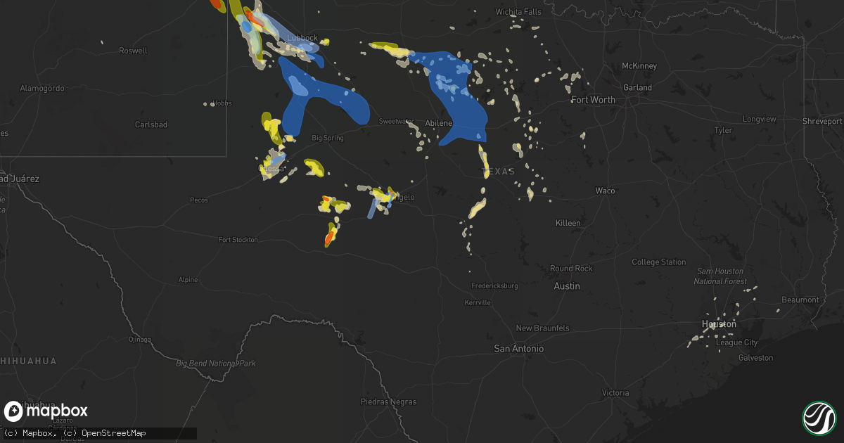
Hail Map in Texas on June 22, 2020
Get this storm
June 22 map
$229
one time, instant access
Download today. No call, no setup
Keep the $229
Bought the map and want the full workflow? Apply the entire $229 to a subscription within 7 days. None of it is wasted.
Every map, not just this one
This buys you this map. Subscription and you get every map we run, in the markets you choose from a few cities to whole states to nationwide. Plus real-time alerts the moment a storm fires.
Contact data
Name, contact info, occupancy, even credit band for addresses in the footprint. You go from where it hit to who to call.
Become the source they trust
Unlimited branding weather history reports on demand. You already have the documented answer ready for the property owner, and you are the one who showed up with it.
Property data and RoofTrace estimates
Pull up any address you have got, its value and the exact code rules for that jurisdiction, straight from One Click Code. Then RoofTrace estimates the squares, pitch, and roof value, priced the way you price.
Storm reports in Texas
Texas
| Date | Description |
|---|---|
| 06/22/20206:55 PM CDT | Late report... With picture... On facebook of half-dollar size hail. Time estimated from radar. |
| 06/22/20206:17 PM CDT | A local report indicates 1.00 inch wind near 6 SSW TEXHOMA |
| 06/22/20201:26 PM CDT | Corrects previous tstm wnd gst report from 3 sw san angelo. Damaging thunderstorm winds blew a large section of the metal roof off of a hotel. |
| 06/22/20207:13 AM CDT | At 1212 AM CDT, severe thunderstorms were located along a line extending from near Rush Springs to near Lawton to 5 miles northeast of Headrick, moving southeast at 20 mph. HAZARD...60 mph wind gusts. SOURCE...Radar indicated. IMPACT...Expect damage to roofs, siding, and trees. Locations impacted include... Lawton, Duncan, Anadarko, Marlow, Frederick, Walters, Cache, Elgin, Comanche, Apache, Snyder, Geronimo, Rush Springs, Bray, Fletcher, Cyril, Grandfield, Temple, Tipton and Sterling. |
| 06/22/20206:58 AM CDT | At 1155 PM CDT, severe thunderstorms were located along a line extending from near Crosbyton to near Plains, moving southeast at 50 mph. This storm has a history of wind damage across areas to the northwest. These are very dangerous storms. HAZARD...80 mph wind gusts and quarter size hail. SOURCE...Radar indicated. IMPACT...Flying debris will be dangerous to those caught without shelter. Mobile homes will be heavily damaged. Expect considerable damage to roofs, windows, and vehicles. Extensive tree damage and power outages are likely. Locations impacted include... Snyder, Lamesa, Seminole, Seagraves, Ackerly, Gail, Seagraves Airport, Gaines County Airport, Welch, Fluvanna, J B Thomas Reservoir, Lamesa Municipal Airport, Los Ybanez, Patricia, Arvana, Hancock, McKenzie Lake, Dunn, Gaines County Park and Loop. |
| 06/22/20206:57 AM CDT | At 1156 PM CDT, severe thunderstorms were located along a line extending from 5 miles northwest of Tokio to 7 miles west of Tahoka, moving south at 30 mph. HAZARD...70 mph wind gusts. SOURCE...Radar indicated. IMPACT...Expect considerable tree damage. Damage is likely to mobile homes, roofs, and outbuildings. Locations impacted include... Brownfield, Tahoka, O'donnell, Grassland, Locketville, New Moore, Tokio, Meadow, Wilson, New Home and Wellman. |
| 06/22/20206:50 AM CDT | At 1150 PM CDT, a severe thunderstorm was located 7 miles west of Garden City, moving east at 55 mph. HAZARD...70 mph wind gusts and quarter size hail. SOURCE...Radar indicated. IMPACT...Hail damage to vehicles is expected. Expect considerable tree damage. Wind damage is also likely to mobile homes, roofs, and outbuildings. Locations impacted include... Garden City. |
| 06/22/20206:27 AM CDT | At 1125 PM CDT, a severe thunderstorm was located near Whitharral, or 11 miles south of Littlefield, moving east at 40 mph. This is a very dangerous storm. HAZARD...80 mph wind gusts. SOURCE...Radar indicated. IMPACT...Flying debris will be dangerous to those caught without shelter. Mobile homes will be heavily damaged. Expect considerable damage to roofs, windows, and vehicles. Extensive tree damage and power outages are likely. Locations impacted include... Lubbock, Levelland, Littlefield, Slaton, Abernathy, Wolfforth, Shallowater, Idalou, Sundown, Petersburg, Anton, Ransom Canyon, Spade, Lubbock South Plains Mall, Slide, Woodrow, Reese Center, Lubbock International Airport, Texas Tech University and Whitharral. |
| 06/22/20206:19 AM CDT | At 1118 PM MDT, a severe thunderstorm was located near Arch, or 12 miles east of Portales, moving southeast at 35 mph. HAZARD...60 mph wind gusts and quarter size hail. SOURCE...Radar indicated. IMPACT...Hail damage to vehicles is expected. Expect wind damage to roofs, siding, and trees. Locations impacted include... Causey, Arch and Rogers. |
| 06/22/20206:14 AM CDT | At 1112 PM CDT, a severe thunderstorm was located 9 miles north of Midland, moving east at 20 mph. HAZARD...60 mph wind gusts and quarter size hail. SOURCE...Radar indicated. IMPACT...Hail damage to vehicles is expected. Expect wind damage to roofs, siding, and trees. Locations impacted include... Midland, Stanton, Lenorah, Tarzan, Courtney and Stanton Municipal Aiport.This includes Interstate 20 between mile markers 151 and 161. |
| 06/22/20206:06 AM CDT | Garage doors damaged... Fences blown down... And minor roof damage reported. Time estimated via radar. |
| 06/22/20205:57 AM CDT | At 1056 PM CDT, severe thunderstorms were located along a line extending from 3 miles south of Hart to 6 miles east of Bula, moving southeast at 25 mph. HAZARD...70 mph wind gusts and nickel size hail. SOURCE...Radar indicated. IMPACT...Expect considerable tree damage. Damage is likely to mobile homes, roofs, and outbuildings. Locations impacted include... Levelland, Littlefield, Olton, Hart, Earth, Anton, Sudan, Amherst, Fieldton, Spade, Halfway, Whitharral, Edmonson and Springlake. |
| 06/22/20205:44 AM CDT | At 1044 PM CDT, a severe thunderstorm was located near Midland International Air and Space Port, or near Midland, moving east at 35 mph. HAZARD...70 mph wind gusts and quarter size hail. SOURCE...Radar indicated. IMPACT...Hail damage to vehicles is expected. Expect considerable tree damage. Wind damage is also likely to mobile homes, roofs, and outbuildings. Locations impacted include... Midland, Odessa, Greenwood, Midland International Air and Space Port, Cotton Flat, Warfield, Midland Airpark and Skywest Airport.This includes Interstate 20 between mile markers 123 and 148. |
| 06/22/20205:14 AM CDT | At 1014 PM CDT, a severe thunderstorm was located 10 miles east of Andrews, moving southeast at 25 mph. HAZARD...60 mph wind gusts and quarter size hail. SOURCE...Radar indicated. IMPACT...Hail damage to vehicles is expected. Expect wind damage to roofs, siding, and trees. Locations impacted include... Midland and Tarzan. This includes Interstate 20 between mile markers 144 and 145. |
| 06/22/20204:59 AM CDT | At 958 PM CDT, severe thunderstorms were located along a line extending from 4 miles east of Vigo Park to 10 miles north of Hart to 4 miles southeast of Friona, moving southeast at 25 mph. HAZARD...60 mph wind gusts and quarter size hail. SOURCE...Radar indicated. IMPACT...Hail damage to vehicles is expected. Expect wind damage to roofs, siding, and trees. Locations impacted include... Plainview, Tulia, Dimmitt, Friona, Olton, Hart, Earth, Silverton, Kress, Happy, Summerfield, Vigo Park, Easter, Lazbuddie, South Plains, Claytonville, Mackenzie Reservoir, Aiken, Black and Halfway. |
| 06/22/20204:54 AM CDT | At 954 PM CDT, a severe thunderstorm was located over West Odessa, or 7 miles southwest of Odessa, moving southeast at 25 mph. HAZARD...60 mph wind gusts and quarter size hail. SOURCE...Radar indicated. IMPACT...Hail damage to vehicles is expected. Expect wind damage to roofs, siding, and trees. Locations impacted include... Odessa, West Odessa, Odessa Schlemeyer Field, Skywest Airport and Pleasant Farms.This includes Interstate 20 between mile markers 102 and 127. |
| 06/22/20204:53 AM CDT | At 952 PM MDT, a severe thunderstorm was located near Cannon Air Force Base, or near Clovis, moving southeast at 15 mph. HAZARD...60 mph wind gusts and quarter size hail. SOURCE...Radar indicated. IMPACT...Hail damage to vehicles is expected. Expect wind damage to roofs, siding, and trees. Locations impacted include... Clovis, Portales, Farwell, Texico, Dora, Cannon Air Force Base, Arch, Oasis State Park, Portair and Rogers.This includes Highway 60 between Mile Markers 381 and 397. |
| 06/22/20204:45 AM CDT | At 945 PM CDT, a severe thunderstorm was located 9 miles north of Reagan County Airport, or 10 miles north of Big Lake, moving south at 20 mph. HAZARD...60 mph wind gusts and half dollar size hail. SOURCE...Radar indicated. IMPACT...Hail damage to vehicles is expected. Expect wind damage to roofs, siding, and trees. Locations impacted include... Big Lake, Reagan County Airport, Best and Stiles. |
| 06/22/20204:35 AM CDT | At 935 PM CDT, a severe thunderstorm was located 10 miles southeast of Wolf Creek Park, or 13 miles southwest of Lipscomb, moving southeast at 15 mph. HAZARD...60 mph wind gusts and half dollar size hail. SOURCE...Radar indicated. IMPACT...Minor damage to roofs, siding, and trees is possible. Hail damage to vehicles is expected. Locations impacted include... Glazier. |
| 06/22/20204:18 AM CDT | At 917 PM CDT, severe thunderstorms were located along a line extending from 3 miles southwest of Goodnight to near Happy, moving south at 40 mph. HAZARD...60 mph wind gusts. SOURCE...Radar indicated. IMPACT...Minor damage to roofs, siding, and trees is possible. Locations impacted include... Pampa, Clarendon, Mclean, Lefors, Howardwick, Lelia Lake, Lake Mcclellan, Wayside, Kingsmill, Alanreed, Greenbelt Lake and Goodnight. |
| 06/22/20204:07 AM CDT | At 906 PM CDT, severe thunderstorms were located along a line extending from 3 miles northwest of Palo Duro Canyon to 6 miles east of Hereford, moving south at 30 mph. HAZARD...60 mph wind gusts and quarter size hail. SOURCE...Radar indicated. IMPACT...Hail damage to vehicles is expected. Expect wind damage to roofs, siding, and trees. Locations impacted include... Tulia, Dimmitt, Hart, Happy, Vigo Park, Easter, Mackenzie Reservoir and Nazareth. |
| 06/22/20203:59 AM CDT | At 858 PM CDT, a severe thunderstorm was located 17 miles north of Big Lake, moving east at 15 mph. HAZARD...60 mph wind gusts and quarter size hail. SOURCE...Radar indicated. IMPACT...Hail damage to vehicles is expected. Expect wind damage to roofs, siding, and trees. This severe thunderstorm will remain over mainly rural areas of northeastern Reagan County. |
| 06/22/20203:43 AM CDT | At 841 PM MDT, a severe thunderstorm was located near Arch, or 11 miles southeast of Portales, moving southeast at 20 mph. HAZARD...Tennis ball size hail and 60 mph wind gusts. SOURCE...At 813 pm MDT trained storm spotters reported tennis ball sized hail. IMPACT...People and animals outdoors will be injured. Expect hail damage to roofs, siding, windows, and vehicles. Expect wind damage to roofs, siding, and trees. Locations impacted include... Dora, Causey, Milnesand, Lingo, Arch, Pep and Rogers. |
| 06/22/20203:43 AM CDT | At 842 PM CDT, severe thunderstorms were located along a line extending from 4 miles southeast of Dumas to 9 miles east of Valley De Oro, moving east at 10 mph. HAZARD...60 mph wind gusts. SOURCE...Radar indicated. IMPACT...Minor damage to roofs, siding, and trees is possible. Winds may occur with very little lightning. Locations impacted include... Amarillo, Dumas, Cactus, Fritch, Sunray, Four Way, Valley De Oro, Masterson and Lake Meredith. |
| 06/22/20203:35 AM CDT | At 835 PM CDT, severe thunderstorms were located along a line extending from near Sanford to 10 miles west of Panhandle, moving southeast at 40 mph. HAZARD...Ping pong ball size hail and 60 mph wind gusts. SOURCE...Radar indicated. IMPACT...Minor damage to roofs, siding, and trees is possible. People and animals outdoors will be injured. Locations impacted include... Borger, Fritch, Stinnett, Skellytown, Sanford and Pringle. |
| 06/22/20203:34 AM CDT | At 834 PM CDT, a severe thunderstorm outflow winds located over Lake Nasworthy, or near San Angelo, moving northeast at 15 mph. HAZARD...70 mph wind gusts. SOURCE...Radar indicated. IMPACT...Expect considerable tree damage. Damage is likely to mobile homes, roofs, and outbuildings. This severe thunderstorm will be near... San Angelo and Goodfellow Air Force Base around 900 PM CDT. |
| 06/22/20203:22 AM CDT | At 822 PM CDT, a severe thunderstorm was located near Twin Buttes Reservoir, or 8 miles south of San Angelo, moving south at 15 mph. HAZARD...60 mph wind gusts. SOURCE...Radar indicated. IMPACT...Expect damage to roofs, siding, and trees. This severe thunderstorm will remain over mainly rural areas of southeastern Tom Green County. |
| 06/22/20203:10 AM CDT | At 810 PM CDT, a severe thunderstorm was located 5 miles southeast of Farnsworth, or 10 miles southwest of Perryton, moving northeast at 10 mph. HAZARD...Tennis ball size hail and 60 mph wind gusts. SOURCE...Radar indicated. IMPACT...Damage to roofs, siding, and trees is possible. People and animals outdoors will be injured. Expect hail damage to roofs, siding, windows, and vehicles. Locations impacted include... Perryton, Wolf Creek Park, Waka and Farnsworth. |
| 06/22/20203:05 AM CDT | At 804 PM CDT, severe thunderstorms were located along a line extending from Boys Ranch to 4 miles southwest of Adrian, moving southeast at 40 mph. These are very dangerous storms. HAZARD...80 mph wind gusts and golf ball size hail. SOURCE...Trained weather spotters. IMPACT...Flying debris will be dangerous to those caught without shelter. Mobile homes could be heavily damaged. Expect considerable damage to roofs, windows, and vehicles. Tree damage and power outages are possible. People and animals outdoors will be injured. Expect hail damage to roofs, siding, windows, and vehicles. Locations impacted include... Vega, Adrian, Boys Ranch and Wildorado. |
| 06/22/20203:05 AM CDT | At 805 PM CDT, severe thunderstorms were located along a line extending from 10 miles northeast of Barnhart to 8 miles south of Mertzon to 6 miles west of Christoval, moving south at 30 mph. HAZARD...60 mph wind gusts. SOURCE...Radar indicated. IMPACT...Expect damage to roofs, siding, and trees. These severe thunderstorms will remain over mainly rural areas of northwestern Schleicher, south central Tom Green, northeastern Crockett and southeastern Irion Counties, including the following locations... Us-190 Near The Crockett-Sutton County Line, The Intersection Of Ranch Road 1828 And Ranch Road 915 and The Intersection Of Us-190 And Ranch Road 1828. |
| 06/22/20203:01 AM CDT | At 800 PM CDT, severe thunderstorms were located along a line extending from 8 miles east of Four Way to 4 miles southeast of Vega, moving southeast at 50 mph. These are very dangerous storms. HAZARD...80 mph wind gusts and golf ball size hail. SOURCE...Trained weather spotters. IMPACT...Flying debris will be dangerous to those caught without shelter. Mobile homes could be heavily damaged. Expect considerable damage to roofs, windows, and vehicles. Tree damage and power outages are possible. People and animals outdoors will be injured. Expect hail damage to roofs, siding, windows, and vehicles. Locations impacted include... Amarillo, Hereford, Canyon, Panhandle, Claude, Lake Tanglewood, Buffalo Lake, Bushland, Washburn, Umbarger, Bootleg, Goodnight, Palo Duro Canyon, Mescalero Park, Dawn, Simms, Timbercreek Canyon and Pantex. |
| 06/22/20202:52 AM CDT | At 751 PM CDT, a severe thunderstorm was located near Sherwood, moving south at 15 mph. HAZARD...70 mph wind gusts and penny size hail. SOURCE...Radar indicated. IMPACT...Expect considerable tree damage. Damage is likely to mobile homes, roofs, and outbuildings. This severe thunderstorm will be near... Sherwood and Knickerbocker around 80..5 PM CDT. Mertzon around 810 PM CDT. |
| 06/22/20202:42 AM CDT | At 742 PM CDT, a severe thunderstorm was located 7 miles northwest of Canadian, moving southeast at 10 mph. HAZARD...Golf ball size hail and 60 mph wind gusts. SOURCE...Radar indicated. IMPACT...Minor damage to roofs, siding, and trees is possible. People and animals outdoors will be injured. Expect hail damage to roofs, siding, windows, and vehicles. Locations impacted include... Canadian, Glazier and Lake Marvin. |
| 06/22/20202:36 AM CDT | Mesonet station 97 throckmorton 1sw. |
| 06/22/20202:36 AM CDT | At 736 PM CDT, severe thunderstorms were located along a line extending from 4 miles southwest of Dumas to 8 miles west of Boys Ranch, moving southeast at 45 mph. HAZARD...60 mph wind gusts and quarter size hail. SOURCE...Radar indicated. IMPACT...Minor damage to roofs, siding, and trees is possible. Hail damage to vehicles is expected. Locations impacted include... Amarillo and Valley De Oro. |
| 06/22/20202:32 AM CDT | At 731 PM CDT, a severe thunderstorm was located over Sanford, or 7 miles west of Borger, moving northeast at 15 mph. HAZARD...Ping pong ball size hail and 60 mph wind gusts. SOURCE...Radar indicated. IMPACT...Minor damage to roofs, siding, and trees is possible. People and animals outdoors will be injured. Expect hail damage to roofs, siding, windows, and vehicles. Locations impacted include... Borger, Fritch, Stinnett and Sanford. |
| 06/22/20202:31 AM CDT | At 731 PM CDT, severe thunderstorms were located along a line extending from 18 miles south of Sterling City to near Arden to near San Angelo State Park, moving south at 15 mph. HAZARD...60 mph wind gusts and quarter size hail. SOURCE...Radar indicated. IMPACT...Hail damage to vehicles is expected. Expect wind damage to roofs, siding, and trees. Severe thunderstorms will be near... Arden around 745 PM CDT. Tankersley around 815 PM CDT.Other locations impacted by these severe thunderstorms include Us-67 Near The Irion-Tom Green County Line. |
| 06/22/20202:25 AM CDT | At 725 PM CDT, a severe thunderstorm was located 16 miles southwest of Barnhart, or 16 miles south of Big Lake, moving south at 15 mph. HAZARD...60 mph wind gusts and quarter size hail. SOURCE...Radar indicated. IMPACT...Hail damage to vehicles is expected. Expect wind damage to roofs, siding, and trees. This severe thunderstorm will remain over mainly rural areas of northeastern Crockett County. |
| 06/22/20202:24 AM CDT | Mesonet station 92 clyde/callahan county. |
| 06/22/20202:23 AM CDT | At 722 PM CDT, a severe thunderstorm was located over San Angelo, moving south at 15 mph. HAZARD...Two inch hail and 60 mph wind gusts. SOURCE...Radar indicated. IMPACT...People and animals outdoors will be injured. Expect hail damage to roofs, siding, windows, and vehicles. Expect wind damage to roofs, siding, and trees. This severe thunderstorm will be near... Goodfellow Air Force Base around 730 PM CDT. Lake Nasworthy around 740 PM CDT. Twin Buttes Reservoir around 745 PM CDT. Wall around 755 PM CDT.Other locations impacted by this severe thunderstorm include Harriet. |
| 06/22/20202:17 AM CDT | At 717 PM CDT, a severe thunderstorm was located over Spearman, moving east at 15 mph. HAZARD...60 mph wind gusts and quarter size hail. SOURCE...Radar indicated. IMPACT...Minor damage to roofs, siding, and trees is possible. Hail damage to vehicles is expected. Locations impacted include... Spearman, Gruver, Wolf Creek Park and Waka. |
| 06/22/20202:12 AM CDT | At 711 PM MDT, a severe thunderstorm was located near Logan, or 18 miles northeast of Tucumcari, moving southeast at 15 mph. HAZARD...Ping pong ball size hail and 60 mph wind gusts. SOURCE...Radar indicated. IMPACT...People and animals outdoors will be injured. Expect hail damage to roofs, siding, windows, and vehicles. Expect wind damage to roofs, siding, and trees. Locations impacted include... Logan, San Jon, Ute Lake State Park, Wheatland and Bard. This includes Interstate 40 between Mile Markers 342 and 371. |
| 06/22/20202:10 AM CDT | Snyder 3e mesonet |
| 06/22/20202:01 AM CDT | At 701 PM CDT, severe thunderstorms were located along a line extending from 5 miles south of Stratford to 9 miles north of Sunray, moving southwest at 25 mph. HAZARD...Two inch hail and 60 mph wind gusts. SOURCE...Radar indicated. IMPACT...Minor damage to roofs, siding, and trees is possible. People and animals outdoors will be injured. Expect hail damage to roofs, siding, windows, and vehicles. Locations impacted include... Dumas, Cactus, Fritch, Sunray, Channing, Four Way, Masterson and Lake Meredith. |
| 06/22/20201:57 AM CDT | At 656 PM MDT, a severe thunderstorm was located 9 miles north of Melrose, or 23 miles northwest of Clovis, moving southeast at 20 mph. HAZARD...Two inch hail and 60 mph wind gusts. SOURCE...Radar indicated. IMPACT...People and animals outdoors will be injured. Expect hail damage to roofs, siding, windows, and vehicles. Expect wind damage to roofs, siding, and trees. Locations impacted include... Clovis, Texico, Melrose, Floyd, Saint Vrain, Cannon Air Force Base, Ranchvale, Oasis State Park and Portair.This includes Highway 60 between Mile Markers 348 and 397. |
| 06/22/20201:57 AM CDT | At 656 PM CDT, a severe thunderstorm was located 11 miles north of Vega, moving east at 5 mph. HAZARD...Ping pong ball size hail and 60 mph wind gusts. SOURCE...Radar indicated. IMPACT...Minor damage to roofs, siding, and trees is possible. People and animals outdoors will be injured. Expect hail damage to roofs, siding, windows, and vehicles. Locations impacted include... Vega, Boys Ranch and Wildorado. |
| 06/22/20201:52 AM CDT | At 651 PM CDT, a severe thunderstorm was located over O.c. Fisher Reservoir, or near San Angelo, moving southeast at 15 mph. HAZARD...60 mph wind gusts and quarter size hail. SOURCE...Radar indicated. IMPACT...Hail damage to vehicles is expected. Expect wind damage to roofs, siding, and trees. This severe thunderstorm will be near... San Angelo around 655 PM CDT. Goodfellow Air Force Base around 730 PM CDT. |
| 06/22/20201:37 AM CDT | A roof was blown off... A porch destroyed... And a fence blown down |
| 06/22/20201:36 AM CDT | At 635 PM CDT, severe thunderstorms were located along a line extending from 6 miles west of Gruver to 3 miles south of Spearman, moving south at 15 mph. HAZARD...Ping pong ball size hail and 60 mph wind gusts. SOURCE...Radar indicated. IMPACT...Minor damage to roofs, siding, and trees is possible. People and animals outdoors will be injured. Expect hail damage to roofs, siding, windows, and vehicles. Locations impacted include... Spearman, Gruver and Morse. |
| 06/22/20201:33 AM CDT | A local report indicates 61 MPH wind near 1 SSE LOMAX |
| 06/22/20201:33 AM CDT | At 632 PM CDT, severe thunderstorms were located along a line extending from 13 miles south of Felt to 6 miles east of Amistad, moving east at 35 mph. HAZARD...60 mph wind gusts and quarter size hail. SOURCE...Radar indicated. IMPACT...Minor damage to roofs, siding, and trees is possible. Hail damage to vehicles is expected. Locations impacted include... Dalhart, Hartley, Ware, Romero and Conlen. |
| 06/22/20201:32 AM CDT | At 632 PM CDT, a severe thunderstorm was located 7 miles east of Big Lake, moving southeast at 5 mph. HAZARD...60 mph wind gusts and half dollar size hail. SOURCE...Radar indicated. IMPACT...Hail damage to vehicles is expected. Expect wind damage to roofs, siding, and trees. This severe thunderstorm will remain over mainly rural areas of southeastern Reagan County. |
| 06/22/20201:25 AM CDT | A local report indicates 58 MPH wind near 3 WNW FLUVANNA |
| 06/22/20201:15 AM CDT | A local report indicates 61 MPH wind near 2 WNW TARZAN |
| 06/22/20201:13 AM CDT | At 613 PM MDT, a severe thunderstorm was located 7 miles southeast of Ragland, or 28 miles south of Tucumcari, moving southeast at 25 mph. HAZARD...60 mph wind gusts and quarter size hail. SOURCE...Radar indicated. IMPACT...Hail damage to vehicles is expected. Expect wind damage to roofs, siding, and trees. Locations impacted include... Melrose, Grady, House, Saint Vrain, Ragland, Broadview, Wheatland, Bellview, Forrest and Mcalister.This includes Highway 60 between Mile Markers 347 and 371. |
| 06/22/20201:10 AM CDT | A local report indicates 63 MPH wind near 2 ESE GAIL |
| 06/22/20201:05 AM CDT | Measured at the hefner station of the west texas mesonet. |
| 06/22/202012:55 AM CDT | A local report indicates 78 MPH wind near 2 NE LAMESA |
| 06/22/202012:50 AM CDT | At 549 PM CDT, a severe thunderstorm was located 8 miles south of Eva, or 22 miles south of Elkhart, moving east at 20 mph. HAZARD...60 mph wind gusts and quarter size hail. SOURCE...Radar indicated. IMPACT...Minor damage to roofs, siding, and trees is possible. Hail damage to vehicles is expected. Locations impacted include... Guymon, Goodwell and Texhoma. |
| 06/22/202012:49 AM CDT | At 548 PM CDT, a severe thunderstorm was located 15 miles north of Barnhart, or 18 miles west of Mertzon, moving southeast at 15 mph. HAZARD...60 mph wind gusts and quarter size hail. SOURCE...Radar indicated. IMPACT...Hail damage to vehicles is expected. Expect wind damage to roofs, siding, and trees. This severe thunderstorm will remain over mainly rural areas of central Irion County. |
| 06/22/202012:25 AM CDT | A local report indicates 72 MPH wind near WELCH |
| 06/22/202012:19 AM CDT | A local report indicates 58 MPH wind near NEW HOME |
| 06/22/202012:17 AM CDT | A local report indicates 62 MPH wind near WELCH |
| 06/22/202012:05 AM CDT | A local report indicates 68 MPH wind near 6 NW WHITE RIVER LAKE |
| 06/22/202012:05 AM CDT | A local report indicates 60 MPH wind near 6 SSW WOLFFORTH |
| 06/22/202012:00 AM CDT | Powerline down near 31st st. And peoria ave. |
| 06/21/202011:45 PM CDT | A local report indicates 71 MPH wind near SMYER |
| 06/21/202011:40 PM CDT | A local report indicates 67 MPH wind near 4 S LEVELLAND |
| 06/21/202011:30 PM CDT | A local report indicates 66 MPH wind near 8 WSW SUNDOWN |
| 06/21/202011:10 PM CDT | Powerlines knocked down in the city. |
| 06/21/202010:46 PM CDT | Multiple power lines snapped in half and brick fence posts blown down near the intersection of sh158 and sh191 |
| 06/21/202010:45 PM CDT | A local report indicates 77 MPH wind near 1 ENE MORTON |
| 06/21/202010:43 PM CDT | A local report indicates 63 MPH wind near 9 WSW EARTH |
| 06/21/202010:40 PM CDT | A local report indicates 61 MPH wind near MIDLAND INTERNATIONAL A |
| 06/21/202010:25 PM CDT | A local report indicates 59 MPH wind near 9 WSW EARTH |
| 06/21/202010:18 PM CDT | A local report indicates 1.00 inch wind near 4 NNW ODESSA |
| 06/21/202010:17 PM CDT | A local report indicates 1.75 inch wind near 1 E HIGGINS |
| 06/21/202010:15 PM CDT | A local report indicates 1.25 inch wind near ODESSA |
| 06/21/202010:00 PM CDT | Late social media report: picture of large hail stone that is between egg and tennis ball sized. Picture also showed significant windshield damage due to large hail. |
| 06/21/20209:41 PM CDT | A local report indicates 1.00 inch wind near 6 WSW LIPSCOMB |
| 06/21/20209:35 PM CDT | Near zero visibility due to wind driven rain. |
| 06/21/20209:28 PM CDT | At 228 AM CDT, a severe thunderstorm was located 4 miles northeast of Briscoe, or 20 miles south of Canadian, moving southeast at 20 mph. HAZARD...60 mph wind gusts and quarter size hail. SOURCE...Radar indicated. IMPACT...Minor damage to roofs, siding, and trees is possible. Hail damage to vehicles is expected. Locations impacted include... Briscoe and Allison. |
| 06/21/20209:15 PM CDT | A local report indicates 68 MPH wind near 12 SW CLAUDE |
| 06/21/20209:09 PM CDT | A local report indicates 63 MPH wind near 12 SW CLAUDE |
| 06/21/20209:02 PM CDT | Correction to previous wind report at palo duro reservoir. Peak gust was 63 mph... Not 62 mph. |
| 06/21/20208:40 PM CDT | Spotter indicated trees were bending nearly parallel to the ground during peak winds. |
| 06/21/20208:38 PM CDT | Late social media report: a wood pavillion with a metal roof wes lifted and tossed down an ally. Damage also occured to a vehicle as a result. |
| 06/21/20208:34 PM CDT | Public report relayed by broadcast media. |
| 06/21/20208:32 PM CDT | Asos station ksjt san angelo. |
| 06/21/20208:28 PM CDT | A local report indicates 1.00 inch wind near FRITCH |
| 06/21/20208:27 PM CDT | A local report indicates 62 MPH wind near 9 N AMARILLO |
| 06/21/20208:27 PM CDT | A local report indicates 58 MPH wind near 1 NNW STINNETT |
| 06/21/20208:25 PM CDT | Late report on facebook... With picture... Of tennis ball size hail. Time estimated from radar. |
| 06/21/20208:24 PM CDT | Time estimated from radar. |
| 06/21/20208:21 PM CDT | A local report indicates 2.00 inch wind near 4 S FARNSWORTH |
| 06/21/20208:20 PM CDT | Late report of golf ball size hail. |
| 06/21/20208:15 PM CDT | A local report indicates 63 MPH wind near 1 WNW FRITCH |
| 06/21/20208:15 PM CDT | Picture of half dollar size hail on facebook. |
| 06/21/20208:07 PM CDT | A local report indicates 59 MPH wind near 15 NNW AMARILLO |
| 06/21/20208:00 PM CDT | A local report indicates 67 MPH wind near 3 W DUMAS |
| 06/21/20207:56 PM CDT | Multiple semi trucks flipped at mile marker 35 on interstate 40. Time of event estimated from radar. |
| 06/21/20207:54 PM CDT | A local report indicates 2.00 inch wind near 5 W WILDORADO |
| 06/21/20207:54 PM CDT | Semi truck flipped on interstate 40 at mile marker 42. |
| 06/21/20207:53 PM CDT | Late report from storm chaser of golf ball size hail. Time and location estimated from radar. |
| 06/21/20207:51 PM CDT | A local report indicates 2.00 inch wind near 19 NW OZONA |
| 06/21/20207:51 PM CDT | A local report indicates 1.25 inch wind near VEGA |
| 06/21/20207:51 PM CDT | Asos station ksjt san angelo. |
| 06/21/20207:50 PM CDT | A local report indicates 2.50 inch wind near 2 E VEGA |
| 06/21/20207:50 PM CDT | Late facebook report of quarter-size hail. |
| 06/21/20207:49 PM CDT | A local report indicates 2.25 inch wind near WAKA |
| 06/21/20207:42 PM CDT | A local report indicates 1.75 inch wind near 4 SSE CHANNING |
| 06/21/20207:40 PM CDT | Late facebook pictures received of ten 65 foot power poles and two 40 foot power poles snapped due to thunderstorm winds. Time estimated from radar. |
| 06/21/20207:39 PM CDT | A local report indicates 58 MPH wind near 1 WSW BOYS RANCH |
| 06/21/20207:38 PM CDT | Ping ball hail reported with photo at intersection of highway 15 and county road 28. |
| 06/21/20207:37 PM CDT | A local report indicates 3.25 inch wind near 3 ESE VEGA |
| 06/21/20207:31 PM CDT | A local report indicates 1.00 inch wind near 1 W SAN ANGELO |
| 06/21/20207:26 PM CDT | A national weather service employee estimated a 60 mph wind gust. |
| 06/21/20207:26 PM CDT | Corrects previous tstm wnd gst report from 3 sw san angelo. Corrects previous tstm wnd gst report from 3 sw san angelo. Damaging thunderstorm winds blew a large section |
| 06/21/20207:26 PM CDT | Corrects previous tstm wnd gust report from 5 wnw san angelo. A national weather service employee estimated a 70 mph wind gust. At the nearby san angelo state park... A |
| 06/21/20207:25 PM CDT | A local report indicates 2.50 inch wind near 5 NE CACTUS |
| 06/21/20207:15 PM CDT | The public reported a roof blown off a home 3 blocks east of coliseum drive along 41st street in san angelo. |
| 06/21/20207:12 PM CDT | A ham radio operator estimated a wind gust to 60 mph at buffalo heights. |
| 06/21/20207:08 PM CDT | The public estimated a 70 mph wind gust in the lake view area of san angelo. |
| 06/21/20207:08 PM CDT | The public reported quarter size hail covering the ground in the lake view area of san angelo. |
| 06/21/20207:00 PM CDT | A local report indicates 1.00 inch wind near SPEARMAN |
All States Impacted by Hail Map on June 22, 2020
Cities Impacted by Hail Map on June 22, 2020
- Aliceville, AL
- Perryton, TX
- Ansley, NE
- Lubbock, TX
- Wilson, TX
- Brownfield, TX
- Jacksonville, NC
- Milford, NE
- Silverton, TX
- Boise City, OK
- Stratford, TX
- Boswell, PA
- Ligonier, PA
- Laughlintown, PA
- Mullin, TX
- Sugar Land, TX
- Canadian, TX
- Odessa, TX
- Fordyce, NE
- Crofton, NE
- Lorenzo, TX
- Galesburg, IL
- East Galesburg, IL
- Knoxville, IL
- Cameron, IL
- Monmouth, IL
- Mechanicsville, VA
- Richmond, VA
- Bumpass, VA
- Mineral, VA
- Ewing, NE
- Perrin, TX
- Jacksboro, TX
- Bridgeport, TX
- Dublin, TX
- Gustine, TX
- Channing, TX
- Vega, TX
- Ozona, TX
- Cordell, OK
- Sentinel, OK
- Spearman, TX
- Brownwood, TX
- Melrose, NM
- Wildorado, TX
- Clayton, NM
- Brady, TX
- Rochelle, TX
- Richland Springs, TX
- Charles City, VA
- Comanche, TX
- Stinnett, TX
- Panhandle, TX
- Dumas, TX
- Cactus, TX
- Fritch, TX
- Amarillo, TX
- Borger, TX
- Sunray, TX
- Texhoma, OK
- Masterson, TX
- Columbia, NC
- Oviedo, FL
- Winter Springs, FL
- Casselberry, FL
- San Angelo, TX
- Clearwater, NE
- Henrietta, MO
- Lexington, MO
- Richmond, MO
- Goldsmith, TX
- Berkeley Springs, WV
- Midland, TX
- Big Lake, TX
- Versailles, IL
- Griggsville, IL
- Chambersburg, IL
- Kenney, IL
- Latham, IL
- Chestnut, IL
- Colonial Beach, VA
- King George, VA
- Moseley, VA
- Powhatan, VA
- Midlothian, VA
- Mertzon, TX
- Higgins, TX
- Leesburg, VA
- Hanover, VA
- Old Glory, TX
- Spur, TX
- Aspermont, TX
- Stephenville, TX
- Houston, TX
- Pearland, TX
- Graford, TX
- Hartington, NE
- Rocky, OK
- Whiteface, TX
- Parkston, SD
- Delmont, SD
- Rochester, TX
- Weinert, TX
- Henrico, VA
- Gates, NC
- Corapeake, NC
- Eure, NC
- Sunbury, NC
- Gatesville, NC
- Evant, TX
- Memphis, MO
- Saint Martinville, LA
- Grosse Tete, LA
- Haines City, FL
- Lake Wales, FL
- Hennepin, IL
- Putnam, IL
- Pawhuska, OK
- Bartlesville, OK
- Netawaka, KS
- Powhattan, KS
- Ramah, CO
- Morrisonville, IL
- Pawnee, IL
- Carrollton, MO
- Elberton, GA
- Dewy Rose, GA
- Wichita Falls, TX
- Foss, OK
- Moorefield, WV
- Orlando, FL
- Crown Point, IN
- Spencer, NE
- Maywood, IL
- Melrose Park, IL
- River Forest, IL
- Bellwood, IL
- River Grove, IL
- Elmwood Park, IL
- Petersburg, TX
- Rising Star, TX
- Cisco, TX
- Amherst, TX
- Purcellville, VA
- Hamilton, VA
- Rosenberg, TX
- Richmond, TX
- May, TX
- Cross Plains, TX
- Early, TX
- Vintondale, PA
- Homer City, PA
- Tripp, SD
- Kings Mountain, NC
- Bessemer City, NC
- Breckenridge, TX
- Knotts Island, NC
- Moyock, NC
- Arnett, OK
- Hebron, IN
- Graham, TX
- Olney, TX
- Loving, TX
- Goldthwaite, TX
- Garden City, TX
- Hallam, NE
- Girard, IL
- Henrietta, TX
- Holliday, TX
- Mingus, TX
- Frankfort, IL
- Manhattan, IL
- Stromsburg, NE
- Osceola, NE
- De Leon, TX
- Pierce, NE
- Osmond, NE
- Dalhart, TX
- New Lenox, IL
- Monee, IL
- Elwood, IL
- Joliet, IL
- King William, VA
- Mcalester, OK
- Ropesville, TX
- Meadow, TX
- Fluvanna, TX
- Carlsbad, TX
- Hayes, VA
- Old Fields, WV
- Warrensburg, IL
- Maroa, IL
- Williamston, NC
- Ranger, TX
- Tuscola, IL
- Fairbury, NE
- Carrsville, VA
- Windsor, NC
- Merkel, TX
- Tuscola, TX
- Liberty, TX
- Cleveland, TX
- McVeytown, PA
- Burtonsville, MD
- Fulton, MD
- Spencerville, MD
- Levelland, TX
- Pep, TX
- Cortland, NE
- Pickrell, NE
- Adams, NE
- Hart, TX
- Romney, WV
- Wakefield, VA
- Goodwell, OK
- Fairfax, OK
- Shattuck, OK
- Harpers Ferry, WV
- Quinton, VA
- Sandston, VA
- Andrews, TX
- Wingate, TX
- Winters, TX
- Gruver, TX
- Martell, NE
- Durham, OK
- Follett, TX
- Chantilly, VA
- Centreville, VA
- Fairfax, VA
- Herndon, VA
- Sterling, VA
- Providence Forge, VA
- Gotebo, OK
- Dimmitt, TX
- Nazareth, TX
- Haskell, TX
- Rule, TX
- Avoca, TX
- Stamford, TX
- Electra, TX
- Spotsylvania, VA
- Okeechobee, FL
- Moore Haven, FL
- Tulsa, OK
- Sand Springs, OK
- Capitan, NM
- Carlton, TX
- Hamilton, TX
- Culpeper, VA
- Immokalee, FL
- Hobart, IN
- Merrillville, IN
- Ralston, OK
- Lockney, TX
- Dayton, TX
- Hartley, TX
- Sterling City, TX
- Batavia, NY
- Gardendale, TX
- Hobart, OK
- Bowie, TX
- Slaton, TX
- Courtland, VA
- Mount Pulaski, IL
- Stanton, TX
- Johnson, VT
- Hyde Park, VT
- Randolph, NE
- Mclean, NE
- Mountain View, OK
- Gresham, NE
- Lanexa, VA
- Albany, TX
- Blum, TX
- Throckmorton, TX
- Strawn, TX
- Hico, TX
- Creswell, NC
- Kress, TX
- Hobbsville, NC
- Tyner, NC
- Booker, TX
- Crete, NE
- Pesotum, IL
- Yankton, SD
- Baileyville, KS
- Powells Point, NC
- Jarvisburg, NC
- East Waterford, PA
- Blairs Mills, PA
- Orbisonia, PA
- Newport News, VA
- Yorktown, VA
- Laurinburg, NC
- Channahon, IL
- Wilmington, IL
- Morris, IL
- Maxton, NC
- Tahoka, TX
- Wolfforth, TX
- Blandinsville, IL
- Newburg, MD
- Red Springs, NC
- Shannon, NC
- Raeford, NC
- Arcadia, FL
- Littlefield, TX
- Enning, SD
- Lowland, NC
- Farmersville, IL
- Tovey, IL
- Kincaid, IL
- Bulpitt, IL
- Skippers, VA
- Garysburg, NC
- Whiting, KS
- Beltsville, MD
- Tappahannock, VA
- Abilene, TX
- Atkinson, NE
- Stony Creek, VA
- Yale, VA
- Waverly, VA
- Aurora, NC
- Newsoms, VA
- Franklin, VA
- Labelle, FL
- Granville, IL
- McNabb, IL
- Lueders, TX
- Frostburg, MD
- Indian Lake Estates, FL
- Camden, NC
- South Mills, NC
- Sudan, TX
- Gatesville, TX
- Haymarket, VA
- Gainesville, VA
- Emporia, VA
- Camp Lejeune, NC
- Silver Creek, NE
- Waggoner, IL
- Mcalister, NM
- Cleburne, TX
- Hardesty, OK
- Balko, OK
- Ohiowa, NE
- Strang, NE
- Disputanta, VA
- Rhome, TX
- Newark, TX
- Boyd, TX
- Springtown, TX
- Quitaque, TX
- Cairo, GA
- Thomasville, GA
- Decatur, IL
- Bedford, IA
- New Market, IA
- Clarinda, IA
- Como, NC
- Blue Mound, IL
- Sedley, VA
- Odonnell, TX
- Jamesville, NC
- Plymouth, NC
- Sweetwater, TX
- Montpelier, VA
- Halifax, NC
- Roanoke Rapids, NC
- Crosby, TX
- Denton, NE
- Pleasant Dale, NE
- Morton, TX
- Enochs, TX
- Huntingdon, PA
- Petersburg, PA
- Clarks, NE
- Kissimmee, FL
- Strongstown, PA
- Twin Rocks, PA
- Ebensburg, PA
- Lone Wolf, OK
- Rappahannock Academy, VA
- Washington, NC
- Stokes, NC
- Greenville, NC
- Camden, SC
- Berkeley, IL
- Elmhurst, IL
- Genoa, NE
- Columbus, NE
- Table Rock, NE
- Gaithersburg, MD
- Suffolk, VA
- Gordon, TX
- Holley, NY
- Murfreesboro, NC
- Eufaula, OK
- Roper, NC
- Brookesmith, TX
- Star, TX
- Pavilion, NY
- Glenarm, IL
- Divernon, IL
- Good Hope, GA
- Monroe, GA
- Mason, TX
- Kahoka, MO
- Wayland, MO
- Firth, NE
- Weatherford, TX
- Adamstown, MD
- Macon, GA
- Ruther Glen, VA
- Woodford, VA
- Sedalia, MO
- Wellsville, NY
- Mokena, IL
- Brookeville, MD
- Dayton, MD
- Glenelg, MD
- Waterford, VA
- Silver Spring, MD
- Wagon Mound, NM
- Newcastle, TX
- Weldon, NC
- Jonesville, LA
- Jenks, OK
- Niantic, IL
- Petersburg, VA
- Gail, TX
- Alexandria, NE
- Tobias, NE
- Utica, NE
- Devers, TX
- Beaumont, TX
- Roca, NE
- Paradise, TX
- Poolville, TX
- Babson Park, FL
- Macomb, IL
- Sciota, IL
- Beaverdam, VA
- Woodson, TX
- Canton, GA
- Trent, TX
- Christoval, TX
- Scranton, NC
- Belhaven, NC
- Richland, GA
- Schererville, IN
- Griffith, IN
- Maysville, NC
- Hobbs, NM
- Lovington, NM
- Byron, NY
- Barnsdall, OK
- Elizabeth City, NC
- New Bern, NC
- Randallstown, MD
- Woodstock, MD
- Georgetown, SC
- Geddes, SD
- Cerro Gordo, IL
- Argenta, IL
- Platte, SD
- Shelby, NC
- Grover, NC
- Henryetta, OK
- Poolesville, MD
- Lipscomb, TX
- Livingston, AL
- Spring, TX
- Williamsburg, VA
- Trementina, NM
- Canyon, TX
- Happy, TX
- Hertford, NC
- Belvidere, NC
- Ovalo, TX
- Argyle, IA
- Farmington, IA
- Sturgis, SD
- Boyds, MD
- Dickerson, MD
- Barnesville, MD
- Mission Hill, SD
- Utica, SD
- White Post, VA
- Winchester, VA
- Buena Vista, GA
- Claude, TX
- Rosharon, TX
- Alvin, TX
- Locust Grove, VA
- Needville, TX
- Dexter, KS
- Alberta, VA
- Laurel, MD
- Missouri City, TX
- Filley, NE
- Dill City, OK
- Prue, OK
- Stevensburg, VA
- Elkwood, VA
- Hominy, OK
- Mounds, OK
- Bixby, OK
- Georgetown, DE
- Bridgeville, DE
- Stafford, TX
- Fisher, WV
- Post, TX
- Lake Placid, FL
- Mora, MO
- Snyder, TX
- Bristow, OK
- Naperville, IL
- Lisle, IL
- Addison, IL
- Wheaton, IL
- Lombard, IL
- Glen Ellyn, IL
- Bensenville, IL
- Wood Dale, IL
- Villa Park, IL
- Downers Grove, IL
- Gaston, NC
- Justiceburg, TX
- Ivor, VA
- Miami, TX
- Roy, NM
- Nolan, TX
- Norfolk, NE
- Peru, IL
- Kenansville, FL
- Glenpool, OK
- Kiefer, OK
- Winter Park, FL
- Quanah, TX
- Stephens City, VA
- Doss, TX
- Harper, TX
- Campo, CO
- Capron, VA
- Caddo, TX
- Aldie, VA
- Geneva, NE
- Frostproof, FL
- Watson, AR
- Fredericksburg, VA
- Pollocksville, NC
- Frederick, MD
- Tulia, TX
- Huffman, TX
- Seymour, TX
- Miles, TX
- Belle Glade, FL
- Walkerton, VA
- Saint Stephens Church, VA
- Bruington, VA
- Winton, NC
- Ahoskie, NC
- Verdigre, NE
- Gary, IN
- Valparaiso, IN
- Port Royal, VA
- Clarksville, MD
- Columbia, MD
- Highland, MD
- Ellicott City, MD
- Ashton, MD
- Colerain, NC
- Harrellsville, NC
- Hammon, OK
- Channelview, TX
- Luray, MO
- Plains, TX
- Tokio, TX
- Newville, PA
- Gordo, AL
- Smicksburg, PA
- Gastonia, NC
- Barry, IL
- Ochopee, FL
- Skiatook, OK
- South Bay, FL
- Clewiston, FL
- Braddyville, IA
- Haslet, TX
- Stonington, IL
- Danville, IA
- Niles, MI
- Dowagiac, MI
- Barnhart, TX
- Daykin, NE
- Manquin, VA
- Aylett, VA
- Sadorus, IL
- Charlotte, NC
- Hereford, TX
- Taylorville, IL
- Edinburg, IL
- Virden, IL
- Harvel, IL
- Aledo, TX
- Bellaire, TX
- Boykins, VA
- Bowen, IL
- Grantsville, MD
- Branchville, VA
- Dry Branch, GA
- Toano, VA
- Bishop, GA
- Chesapeake, VA
- Carrollton, VA
- Zuni, VA
- Smithfield, VA
- Windsor, VA
- Warsaw, VA
- Dunnsville, VA
- Great Falls, VA
- Portsmouth, VA
- Norfolk, VA
- Wayside, TX
- Lakeview, TX
- Hedley, TX
- Memphis, TX
- Lelia Lake, TX
- Wellington, TX
- Tell, TX
- Clarendon, TX
- Childress, TX
- Groom, TX
- Earth, TX
- Muleshoe, TX
- Olton, TX
- Friona, TX
- Springlake, TX
- Plainview, TX
- Fieldton, TX
- Hale Center, TX
- Shallowater, TX
- Smyer, TX
- Ackerly, TX
- Hermleigh, TX
- Welch, TX
- Tarzan, TX
- Lenorah, TX
- Lamesa, TX
- Ira, TX
- Colorado City, TX
- Westbrook, TX
- Moran, TX
- Clyde, TX
- Lawn, TX
- O'Brien, TX
- Baird, TX
- McAdenville, NC
- Mount Holly, NC
- Belmont, NC
- Cramerton, NC
- Lowell, NC
- Dansville, NY
- Coleridge, NE
- Clarkson, NE
- Howells, NE
- Scribner, NE
- North Bend, NE
- Cedar Bluffs, NE
- Ames, NE
- Dodge, NE
- Clatonia, NE
- Crab Orchard, NE
- Henry, IL
- Franklin Park, IL
- Hillside, IL
- Des Plaines, IL
- Arlington Heights, IL
- Elk Grove Village, IL
- Matteson, IL
- Richton Park, IL
- Auburn, IL
- Texhoma, TX
- Keyes, OK
- Farwell, TX
- Sundown, TX
- Maple, TX
- Dickens, TX
- Paducah, TX
- New London, IA
- Bourg, LA
- Theriot, LA
- Raceland, LA
- Lockport, LA
- Houma, LA
- Gheens, LA
- Tallulah, LA
- Solano, NM
- Clovis, NM
- Rogers, NM
- Portales, NM
- Ijamsville, MD
- Montgomery Village, MD
- Cooksville, MD
- Woodbine, MD
- Marriottsville, MD
- Sykesville, MD
- West Friendship, MD
- Glenwood, MD
- Gwynn Oak, MD
- Baltimore, MD
- Catonsville, MD
- Mangum, OK
- Honea Path, SC
- Belton, SC


