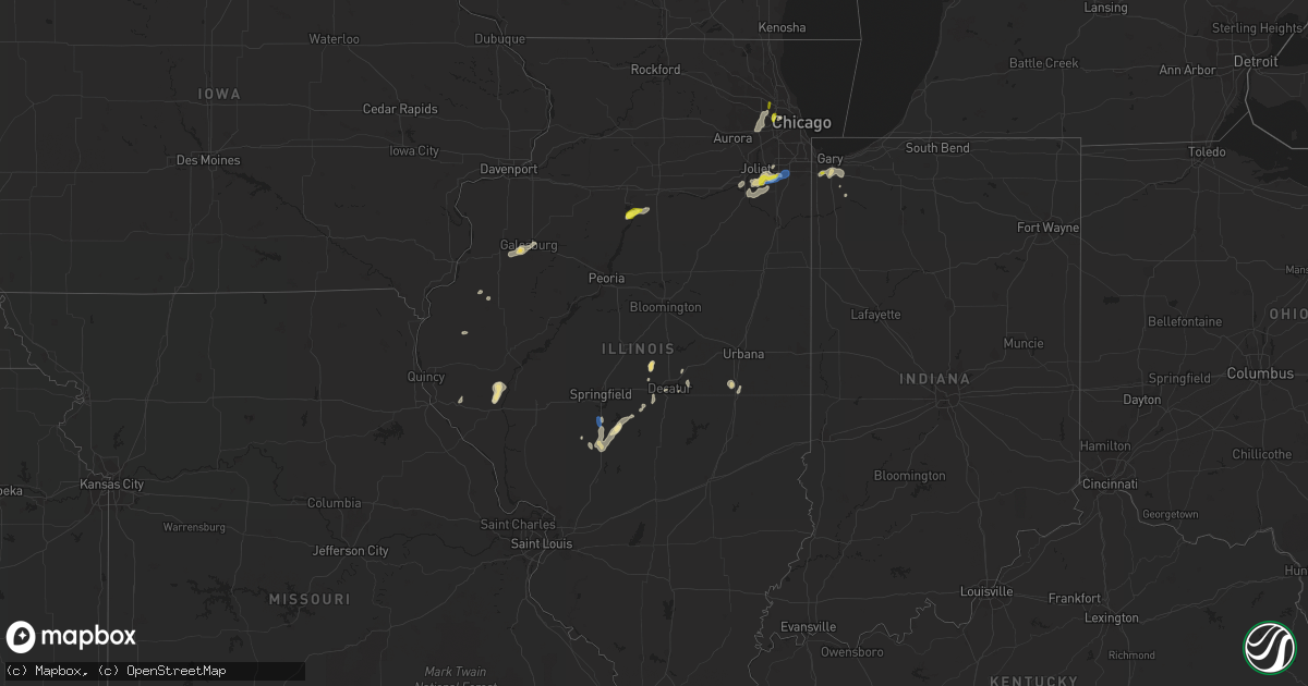
Hail Map in Illinois on June 22, 2020
Get this storm
June 22 map
$229
one time, instant access
Download today. No call, no setup
Keep the $229
Bought the map and want the full workflow? Apply the entire $229 to a subscription within 7 days. None of it is wasted.
Every map, not just this one
This buys you this map. Subscription and you get every map we run, in the markets you choose from a few cities to whole states to nationwide. Plus real-time alerts the moment a storm fires.
Contact data
Name, contact info, occupancy, even credit band for addresses in the footprint. You go from where it hit to who to call.
Become the source they trust
Unlimited branding weather history reports on demand. You already have the documented answer ready for the property owner, and you are the one who showed up with it.
Property data and RoofTrace estimates
Pull up any address you have got, its value and the exact code rules for that jurisdiction, straight from One Click Code. Then RoofTrace estimates the squares, pitch, and roof value, priced the way you price.
Storm reports in Illinois
Illinois
| Date | Description |
|---|---|
| 06/22/20205:42 PM CDT | *delayed report* several reports of trees/limbs down in and around the mount prospect area. Report relayed by public works and time estimated based on radar. |
| 06/22/20204:50 PM CDT | Trees blown down. |
| 06/22/20204:45 PM CDT | Trees blown down |
| 06/22/20204:30 PM CDT | Quarter to half dollar size hail. |
| 06/22/20204:22 PM CDT | Spotter reports hail ranging from 0.75 to 1.0 inch diameter. Relayed via amateur radio operator. |
| 06/22/20203:40 PM CDT | Two trees blown down. 1.5 to 2 feet in diamter. One was blown onto a fence. |
| 06/22/20203:35 PM CDT | Large tree limbs blown down onto road. |
| 06/22/20203:30 PM CDT | Semi-trailer truck blown onto side on northbound i-55. |
| 06/22/20203:30 PM CDT | Three trees down in driveway. 12 inches in diamter... 20 feet in length. |
| 06/22/20203:28 PM CDT | Three power poles snapped |
| 06/22/20203:24 PM CDT | Tree fell on house and damaged power lines. |
| 06/22/20203:17 PM CDT | A local report indicates 60 MPH wind near 1 SE AUBURN |
| 06/22/20201:30 PM CDT | Will county emergency management reports 4 semi trailers blown over by wind along i-55 near arsenal road interchange. Time estimated by radar. |
| 06/22/20201:20 PM CDT | Photo shared via social media shows tree snapped near base. Near 80th avenue and us-30 in frankfort. Time estimated by radar. |
| 06/22/202012:55 PM CDT | Will county sheriffs office reports quarter-sized hail in manhattan. Time estimated by radar. |
| 06/22/20207:36 AM CDT | At 1236 PM CDT, a severe thunderstorm was located over Elwood, or near Channahon, moving northeast at 20 mph. HAZARD...60 mph wind gusts and quarter size hail. SOURCE...Radar indicated. IMPACT...Hail damage to vehicles is expected. Expect wind damage to roofs, siding, and trees. Locations impacted include... Joliet, Orland Park, Tinley Park, Lockport, New Lenox, Homer Glen, Mokena, Frankfort, Channahon, Ingalls Park, Manhattan, Elwood, Rockdale, Goodings Grove, Crest Hill, Frankfort Square, Preston Heights and Fairmont.Including the following interstates... I-55 between mile markers 244 and 246. I-80 between mile markers 131 and 149. I-355 between mile markers 1 and 7.This includes... University of St. Francis, Chicagoland Speedway...Route 66 Raceway, and Joliet Slammers Baseball. |
| 06/22/202012:24 AM CDT | At 523 PM CDT, a severe thunderstorm was located over Bensenville, or near Ohare Airport, moving northeast at 20 mph. HAZARD...60 mph wind gusts. SOURCE...Radar indicated. IMPACT...Expect damage to roofs, siding, and trees. Locations impacted include... Far northwest side of Chicago, Arlington Heights, Evanston, Skokie, Des Plaines, Mount Prospect, Glenview, Elmhurst, Wheeling, Park Ridge, Addison, Northbrook, Wilmette, Morton Grove, Franklin Park, Deerfield, Winnetka, Glencoe, Harwood Heights and Rosemont.Including the following interstates... I-90 between mile markers 71 and 84. I-94 between mile markers 26 and 43. I-290 between mile markers 4 and 5. I-294 between mile markers 26 and 43.This includes... Loyola University, Oakton Community College,Northeastern Illinois University, and Northwestern University. |
| 06/21/202011:51 PM CDT | At 450 PM CDT, severe thunderstorms were located along a line extending from Logan Square to near Downers Grove, moving northeast at 20 mph. HAZARD...60 mph wind gusts and penny size hail. SOURCE...Radar indicated. IMPACT...Expect damage to roofs, siding, and trees. Locations impacted include... Chicago, Cicero, Evanston, Skokie, Des Plaines, Berwyn, Oak Park, Downers Grove, Elmhurst, Lombard, Park Ridge, Addison, Glen Ellyn, Wilmette, Westmont, Maywood, Morton Grove, Lisle, Villa Park and Brookfield.This includes...Brookfield Zoo, Lincoln Park Zoo, Loyola University, Triton College, College of DuPage, Hawthorne Park, Morton Arboretum, Northeastern Illinois University, Northwestern University, Soldier Field, University of Illinois Chicago, Wrigley Field, The Loop, Museum Campus, and Northerly Island. |
| 06/21/202011:40 PM CDT | At 440 PM CDT, a severe thunderstorm was located over Galesburg, moving northeast at 20 mph. HAZARD...60 mph wind gusts and quarter size hail. SOURCE...Radar indicated. IMPACT...Hail damage to vehicles is expected. Expect wind damage to roofs, siding, and trees. Locations impacted include... Galesburg, Knoxville, Wataga, Oneida, Williamsfield, Altona, Victoria, East Galesburg, Henderson, Snake Den Hollow, Dahinda and Galesburg Airport.This includes Interstate 74 between mile markers 40 and 60. |
| 06/21/202011:34 PM CDT | At 434 PM CDT, a severe thunderstorm was located near Macon, or 9 miles southwest of Decatur, moving northeast at 20 mph. HAZARD...60 mph wind gusts. SOURCE...Radar indicated. IMPACT...Expect damage to roofs, siding, and trees. Locations impacted include... Decatur, Mount Zion, Forsyth, Maroa, Cerro Gordo, Harristown, Long Creek, Warrensburg, Blue Mound, Macon, Argenta, Oreana, Niantic, Oakley, Boody, Elwin, Decatur Airport and Hervey City.This includes Interstate 72 between mile markers 126 and 155. |
| 06/21/202011:19 PM CDT | At 418 PM CDT, a severe thunderstorm was located over Melrose Park, or over Franklin Park, moving east at 20 mph. HAZARD...60 mph wind gusts and penny size hail. SOURCE...Radar indicated. IMPACT...Expect damage to roofs, siding, and trees. Locations impacted include... Chicago, Evanston, Skokie, Berwyn, Oak Park, Park Ridge, Wilmette, Maywood, Morton Grove, Franklin Park, Westchester, Forest Park, River Forest, Harwood Heights, Rosemont, Lincoln Park, Navy Pier, Niles, Melrose Park and Bellwood.This includes...Lincoln Park Zoo, Loyola University, Triton College, Northeastern Illinois University, Northwestern University, and Wrigley Field. |
| 06/21/202011:18 PM CDT | At 418 PM CDT, a severe thunderstorm was located near Henry, or near Hennepin, moving northeast at 10 mph. HAZARD...60 mph wind gusts and half dollar size hail. SOURCE...Radar indicated. IMPACT...Hail damage to vehicles is expected. Expect wind damage to roofs, siding, and trees. Locations impacted include... Hennepin, Henry, Granville, McNabb, Putnam, Mark, Magnolia, Standard and Florid. |
| 06/21/202010:39 PM CDT | At 338 PM CDT, a severe thunderstorm was located over Bulpitt, or 10 miles west of Taylorville, moving north at 20 mph. HAZARD...60 mph wind gusts and quarter size hail. SOURCE...Radar indicated. IMPACT...Hail damage to vehicles is expected. Expect wind damage to roofs, siding, and trees. Locations impacted include... Kincaid, Edinburg, Mechanicsburg, Mount Auburn, Bulpitt, Jeisyville, Tovey, Berry, Sangchris Lake State Park, Sicily, Roby and Sharpsburg.This includes Interstate 72 between mile markers 115 and 121. |
| 06/21/202010:27 PM CDT | At 327 PM CDT, a severe thunderstorm was located near Pawnee, or 10 miles south of Springfield, moving north at 25 mph. HAZARD...60 mph wind gusts. SOURCE...Emergency management. IMPACT...Expect damage to roofs, siding, and trees. Locations impacted include... Springfield, Chatham, Auburn, Sherman, Rochester, Riverton, Pawnee, Williamsville, Divernon, Mechanicsburg, Jerome, Southern View, Leland Grove, Grandview, Spaulding, Dawson, Buffalo, Berry, Clear Lake and Cantrall.This includes the following highways... Interstate 55 between mile markers 77 and 111. Interstate 72 between mile markers 92 and 115. |
| 06/21/20209:41 PM CDT | At 241 PM CDT, a severe thunderstorm was located near Harristown, or 10 miles southwest of Decatur, moving north at 20 mph. HAZARD...60 mph wind gusts and quarter size hail. SOURCE...Radar indicated. IMPACT...Hail damage to vehicles is expected. Expect wind damage to roofs, siding, and trees. Locations impacted include... Decatur, Forsyth, Maroa, Mount Pulaski, Harristown, Warrensburg, Macon, Illiopolis, Niantic, Mount Auburn, Latham, Boody and Elwin.This includes Interstate 72 between mile markers 120 and 142. |
| 06/21/20208:28 PM CDT | At 128 PM CDT, a severe thunderstorm was located over Channahon, moving northeast at 20 mph. Another severe thunderstorm is just northwest of Monee. HAZARD...60 mph wind gusts and quarter size hail. SOURCE...Radar indicated. IMPACT...Hail damage to vehicles is expected. Expect wind damage to roofs, siding, and trees. Locations impacted include... Joliet, Orland Park, Tinley Park, Romeoville, Lockport, New Lenox, Homer Glen, Mokena, Frankfort, Channahon, Minooka, University Park, Ingalls Park, Shorewood, Manhattan, Elwood, Rockdale, Goodings Grove, Crest Hill and Frankfort Square.Including the following interstates... I-55 between mile markers 241 and 254. I-57 near mile marker 338. I-80 between mile markers 123 and 149. I-355 between mile markers 1 and 6.This includes... University of St. Francis, Channahon State Park,Chicagoland Speedway...Route 66 Raceway, Joliet Junior College, andJoliet Slammers Baseball. |
| 06/21/20208:12 PM CDT | At 112 PM CDT, a severe thunderstorm was located near Frankfort, moving northeast at 20 mph. HAZARD...60 mph wind gusts and quarter size hail. SOURCE...Radar indicated. IMPACT...Hail damage to vehicles is expected. Expect wind damage to roofs, siding, and trees. Locations impacted include... Orland Park, Tinley Park, Calumet City, Chicago Heights, Lansing, New Lenox, Blue Island, Dolton, Park Forest, Matteson, Mokena, Frankfort, Midlothian, Steger, Flossmoor, Lynwood, Glenwood, University Park, Posen and Olympia Fields.Including the following interstates... I-57 between mile markers 332 and 352. I-80 between mile markers 137 and 138, and between mile markers 140and 155. I-94 between mile markers 68 and 74. I-294 between mile markers 68 and 74.This includes... Hollywood Casino Amphitheatre, Governors StateUniversity, Prairie State College, and South Suburban College. |
All States Impacted by Hail Map on June 22, 2020
Cities Impacted by Hail Map on June 22, 2020
- Aliceville, AL
- Perryton, TX
- Ansley, NE
- Lubbock, TX
- Wilson, TX
- Brownfield, TX
- Jacksonville, NC
- Milford, NE
- Silverton, TX
- Boise City, OK
- Stratford, TX
- Boswell, PA
- Ligonier, PA
- Laughlintown, PA
- Mullin, TX
- Sugar Land, TX
- Canadian, TX
- Odessa, TX
- Fordyce, NE
- Crofton, NE
- Lorenzo, TX
- Galesburg, IL
- East Galesburg, IL
- Knoxville, IL
- Cameron, IL
- Monmouth, IL
- Mechanicsville, VA
- Richmond, VA
- Bumpass, VA
- Mineral, VA
- Ewing, NE
- Perrin, TX
- Jacksboro, TX
- Bridgeport, TX
- Dublin, TX
- Gustine, TX
- Channing, TX
- Vega, TX
- Ozona, TX
- Cordell, OK
- Sentinel, OK
- Spearman, TX
- Brownwood, TX
- Melrose, NM
- Wildorado, TX
- Clayton, NM
- Brady, TX
- Rochelle, TX
- Richland Springs, TX
- Charles City, VA
- Comanche, TX
- Stinnett, TX
- Panhandle, TX
- Dumas, TX
- Cactus, TX
- Fritch, TX
- Amarillo, TX
- Borger, TX
- Sunray, TX
- Texhoma, OK
- Masterson, TX
- Columbia, NC
- Oviedo, FL
- Winter Springs, FL
- Casselberry, FL
- San Angelo, TX
- Clearwater, NE
- Henrietta, MO
- Lexington, MO
- Richmond, MO
- Goldsmith, TX
- Berkeley Springs, WV
- Midland, TX
- Big Lake, TX
- Versailles, IL
- Griggsville, IL
- Chambersburg, IL
- Kenney, IL
- Latham, IL
- Chestnut, IL
- Colonial Beach, VA
- King George, VA
- Moseley, VA
- Powhatan, VA
- Midlothian, VA
- Mertzon, TX
- Higgins, TX
- Leesburg, VA
- Hanover, VA
- Old Glory, TX
- Spur, TX
- Aspermont, TX
- Stephenville, TX
- Houston, TX
- Pearland, TX
- Graford, TX
- Hartington, NE
- Rocky, OK
- Whiteface, TX
- Parkston, SD
- Delmont, SD
- Rochester, TX
- Weinert, TX
- Henrico, VA
- Gates, NC
- Corapeake, NC
- Eure, NC
- Sunbury, NC
- Gatesville, NC
- Evant, TX
- Memphis, MO
- Saint Martinville, LA
- Grosse Tete, LA
- Haines City, FL
- Lake Wales, FL
- Hennepin, IL
- Putnam, IL
- Pawhuska, OK
- Bartlesville, OK
- Netawaka, KS
- Powhattan, KS
- Ramah, CO
- Morrisonville, IL
- Pawnee, IL
- Carrollton, MO
- Elberton, GA
- Dewy Rose, GA
- Wichita Falls, TX
- Foss, OK
- Moorefield, WV
- Orlando, FL
- Crown Point, IN
- Spencer, NE
- Maywood, IL
- Melrose Park, IL
- River Forest, IL
- Bellwood, IL
- River Grove, IL
- Elmwood Park, IL
- Petersburg, TX
- Rising Star, TX
- Cisco, TX
- Amherst, TX
- Purcellville, VA
- Hamilton, VA
- Rosenberg, TX
- Richmond, TX
- May, TX
- Cross Plains, TX
- Early, TX
- Vintondale, PA
- Homer City, PA
- Tripp, SD
- Kings Mountain, NC
- Bessemer City, NC
- Breckenridge, TX
- Knotts Island, NC
- Moyock, NC
- Arnett, OK
- Hebron, IN
- Graham, TX
- Olney, TX
- Loving, TX
- Goldthwaite, TX
- Garden City, TX
- Hallam, NE
- Girard, IL
- Henrietta, TX
- Holliday, TX
- Mingus, TX
- Frankfort, IL
- Manhattan, IL
- Stromsburg, NE
- Osceola, NE
- De Leon, TX
- Pierce, NE
- Osmond, NE
- Dalhart, TX
- New Lenox, IL
- Monee, IL
- Elwood, IL
- Joliet, IL
- King William, VA
- Mcalester, OK
- Ropesville, TX
- Meadow, TX
- Fluvanna, TX
- Carlsbad, TX
- Hayes, VA
- Old Fields, WV
- Warrensburg, IL
- Maroa, IL
- Williamston, NC
- Ranger, TX
- Tuscola, IL
- Fairbury, NE
- Carrsville, VA
- Windsor, NC
- Merkel, TX
- Tuscola, TX
- Liberty, TX
- Cleveland, TX
- McVeytown, PA
- Burtonsville, MD
- Fulton, MD
- Spencerville, MD
- Levelland, TX
- Pep, TX
- Cortland, NE
- Pickrell, NE
- Adams, NE
- Hart, TX
- Romney, WV
- Wakefield, VA
- Goodwell, OK
- Fairfax, OK
- Shattuck, OK
- Harpers Ferry, WV
- Quinton, VA
- Sandston, VA
- Andrews, TX
- Wingate, TX
- Winters, TX
- Gruver, TX
- Martell, NE
- Durham, OK
- Follett, TX
- Chantilly, VA
- Centreville, VA
- Fairfax, VA
- Herndon, VA
- Sterling, VA
- Providence Forge, VA
- Gotebo, OK
- Dimmitt, TX
- Nazareth, TX
- Haskell, TX
- Rule, TX
- Avoca, TX
- Stamford, TX
- Electra, TX
- Spotsylvania, VA
- Okeechobee, FL
- Moore Haven, FL
- Tulsa, OK
- Sand Springs, OK
- Capitan, NM
- Carlton, TX
- Hamilton, TX
- Culpeper, VA
- Immokalee, FL
- Hobart, IN
- Merrillville, IN
- Ralston, OK
- Lockney, TX
- Dayton, TX
- Hartley, TX
- Sterling City, TX
- Batavia, NY
- Gardendale, TX
- Hobart, OK
- Bowie, TX
- Slaton, TX
- Courtland, VA
- Mount Pulaski, IL
- Stanton, TX
- Johnson, VT
- Hyde Park, VT
- Randolph, NE
- Mclean, NE
- Mountain View, OK
- Gresham, NE
- Lanexa, VA
- Albany, TX
- Blum, TX
- Throckmorton, TX
- Strawn, TX
- Hico, TX
- Creswell, NC
- Kress, TX
- Hobbsville, NC
- Tyner, NC
- Booker, TX
- Crete, NE
- Pesotum, IL
- Yankton, SD
- Baileyville, KS
- Powells Point, NC
- Jarvisburg, NC
- East Waterford, PA
- Blairs Mills, PA
- Orbisonia, PA
- Newport News, VA
- Yorktown, VA
- Laurinburg, NC
- Channahon, IL
- Wilmington, IL
- Morris, IL
- Maxton, NC
- Tahoka, TX
- Wolfforth, TX
- Blandinsville, IL
- Newburg, MD
- Red Springs, NC
- Shannon, NC
- Raeford, NC
- Arcadia, FL
- Littlefield, TX
- Enning, SD
- Lowland, NC
- Farmersville, IL
- Tovey, IL
- Kincaid, IL
- Bulpitt, IL
- Skippers, VA
- Garysburg, NC
- Whiting, KS
- Beltsville, MD
- Tappahannock, VA
- Abilene, TX
- Atkinson, NE
- Stony Creek, VA
- Yale, VA
- Waverly, VA
- Aurora, NC
- Newsoms, VA
- Franklin, VA
- Labelle, FL
- Granville, IL
- McNabb, IL
- Lueders, TX
- Frostburg, MD
- Indian Lake Estates, FL
- Camden, NC
- South Mills, NC
- Sudan, TX
- Gatesville, TX
- Haymarket, VA
- Gainesville, VA
- Emporia, VA
- Camp Lejeune, NC
- Silver Creek, NE
- Waggoner, IL
- Mcalister, NM
- Cleburne, TX
- Hardesty, OK
- Balko, OK
- Ohiowa, NE
- Strang, NE
- Disputanta, VA
- Rhome, TX
- Newark, TX
- Boyd, TX
- Springtown, TX
- Quitaque, TX
- Cairo, GA
- Thomasville, GA
- Decatur, IL
- Bedford, IA
- New Market, IA
- Clarinda, IA
- Como, NC
- Blue Mound, IL
- Sedley, VA
- Odonnell, TX
- Jamesville, NC
- Plymouth, NC
- Sweetwater, TX
- Montpelier, VA
- Halifax, NC
- Roanoke Rapids, NC
- Crosby, TX
- Denton, NE
- Pleasant Dale, NE
- Morton, TX
- Enochs, TX
- Huntingdon, PA
- Petersburg, PA
- Clarks, NE
- Kissimmee, FL
- Strongstown, PA
- Twin Rocks, PA
- Ebensburg, PA
- Lone Wolf, OK
- Rappahannock Academy, VA
- Washington, NC
- Stokes, NC
- Greenville, NC
- Camden, SC
- Berkeley, IL
- Elmhurst, IL
- Genoa, NE
- Columbus, NE
- Table Rock, NE
- Gaithersburg, MD
- Suffolk, VA
- Gordon, TX
- Holley, NY
- Murfreesboro, NC
- Eufaula, OK
- Roper, NC
- Brookesmith, TX
- Star, TX
- Pavilion, NY
- Glenarm, IL
- Divernon, IL
- Good Hope, GA
- Monroe, GA
- Mason, TX
- Kahoka, MO
- Wayland, MO
- Firth, NE
- Weatherford, TX
- Adamstown, MD
- Macon, GA
- Ruther Glen, VA
- Woodford, VA
- Sedalia, MO
- Wellsville, NY
- Mokena, IL
- Brookeville, MD
- Dayton, MD
- Glenelg, MD
- Waterford, VA
- Silver Spring, MD
- Wagon Mound, NM
- Newcastle, TX
- Weldon, NC
- Jonesville, LA
- Jenks, OK
- Niantic, IL
- Petersburg, VA
- Gail, TX
- Alexandria, NE
- Tobias, NE
- Utica, NE
- Devers, TX
- Beaumont, TX
- Roca, NE
- Paradise, TX
- Poolville, TX
- Babson Park, FL
- Macomb, IL
- Sciota, IL
- Beaverdam, VA
- Woodson, TX
- Canton, GA
- Trent, TX
- Christoval, TX
- Scranton, NC
- Belhaven, NC
- Richland, GA
- Schererville, IN
- Griffith, IN
- Maysville, NC
- Hobbs, NM
- Lovington, NM
- Byron, NY
- Barnsdall, OK
- Elizabeth City, NC
- New Bern, NC
- Randallstown, MD
- Woodstock, MD
- Georgetown, SC
- Geddes, SD
- Cerro Gordo, IL
- Argenta, IL
- Platte, SD
- Shelby, NC
- Grover, NC
- Henryetta, OK
- Poolesville, MD
- Lipscomb, TX
- Livingston, AL
- Spring, TX
- Williamsburg, VA
- Trementina, NM
- Canyon, TX
- Happy, TX
- Hertford, NC
- Belvidere, NC
- Ovalo, TX
- Argyle, IA
- Farmington, IA
- Sturgis, SD
- Boyds, MD
- Dickerson, MD
- Barnesville, MD
- Mission Hill, SD
- Utica, SD
- White Post, VA
- Winchester, VA
- Buena Vista, GA
- Claude, TX
- Rosharon, TX
- Alvin, TX
- Locust Grove, VA
- Needville, TX
- Dexter, KS
- Alberta, VA
- Laurel, MD
- Missouri City, TX
- Filley, NE
- Dill City, OK
- Prue, OK
- Stevensburg, VA
- Elkwood, VA
- Hominy, OK
- Mounds, OK
- Bixby, OK
- Georgetown, DE
- Bridgeville, DE
- Stafford, TX
- Fisher, WV
- Post, TX
- Lake Placid, FL
- Mora, MO
- Snyder, TX
- Bristow, OK
- Naperville, IL
- Lisle, IL
- Addison, IL
- Wheaton, IL
- Lombard, IL
- Glen Ellyn, IL
- Bensenville, IL
- Wood Dale, IL
- Villa Park, IL
- Downers Grove, IL
- Gaston, NC
- Justiceburg, TX
- Ivor, VA
- Miami, TX
- Roy, NM
- Nolan, TX
- Norfolk, NE
- Peru, IL
- Kenansville, FL
- Glenpool, OK
- Kiefer, OK
- Winter Park, FL
- Quanah, TX
- Stephens City, VA
- Doss, TX
- Harper, TX
- Campo, CO
- Capron, VA
- Caddo, TX
- Aldie, VA
- Geneva, NE
- Frostproof, FL
- Watson, AR
- Fredericksburg, VA
- Pollocksville, NC
- Frederick, MD
- Tulia, TX
- Huffman, TX
- Seymour, TX
- Miles, TX
- Belle Glade, FL
- Walkerton, VA
- Saint Stephens Church, VA
- Bruington, VA
- Winton, NC
- Ahoskie, NC
- Verdigre, NE
- Gary, IN
- Valparaiso, IN
- Port Royal, VA
- Clarksville, MD
- Columbia, MD
- Highland, MD
- Ellicott City, MD
- Ashton, MD
- Colerain, NC
- Harrellsville, NC
- Hammon, OK
- Channelview, TX
- Luray, MO
- Plains, TX
- Tokio, TX
- Newville, PA
- Gordo, AL
- Smicksburg, PA
- Gastonia, NC
- Barry, IL
- Ochopee, FL
- Skiatook, OK
- South Bay, FL
- Clewiston, FL
- Braddyville, IA
- Haslet, TX
- Stonington, IL
- Danville, IA
- Niles, MI
- Dowagiac, MI
- Barnhart, TX
- Daykin, NE
- Manquin, VA
- Aylett, VA
- Sadorus, IL
- Charlotte, NC
- Hereford, TX
- Taylorville, IL
- Edinburg, IL
- Virden, IL
- Harvel, IL
- Aledo, TX
- Bellaire, TX
- Boykins, VA
- Bowen, IL
- Grantsville, MD
- Branchville, VA
- Dry Branch, GA
- Toano, VA
- Bishop, GA
- Chesapeake, VA
- Carrollton, VA
- Zuni, VA
- Smithfield, VA
- Windsor, VA
- Warsaw, VA
- Dunnsville, VA
- Great Falls, VA
- Portsmouth, VA
- Norfolk, VA
- Wayside, TX
- Lakeview, TX
- Hedley, TX
- Memphis, TX
- Lelia Lake, TX
- Wellington, TX
- Tell, TX
- Clarendon, TX
- Childress, TX
- Groom, TX
- Earth, TX
- Muleshoe, TX
- Olton, TX
- Friona, TX
- Springlake, TX
- Plainview, TX
- Fieldton, TX
- Hale Center, TX
- Shallowater, TX
- Smyer, TX
- Ackerly, TX
- Hermleigh, TX
- Welch, TX
- Tarzan, TX
- Lenorah, TX
- Lamesa, TX
- Ira, TX
- Colorado City, TX
- Westbrook, TX
- Moran, TX
- Clyde, TX
- Lawn, TX
- O'Brien, TX
- Baird, TX
- McAdenville, NC
- Mount Holly, NC
- Belmont, NC
- Cramerton, NC
- Lowell, NC
- Dansville, NY
- Coleridge, NE
- Clarkson, NE
- Howells, NE
- Scribner, NE
- North Bend, NE
- Cedar Bluffs, NE
- Ames, NE
- Dodge, NE
- Clatonia, NE
- Crab Orchard, NE
- Henry, IL
- Franklin Park, IL
- Hillside, IL
- Des Plaines, IL
- Arlington Heights, IL
- Elk Grove Village, IL
- Matteson, IL
- Richton Park, IL
- Auburn, IL
- Texhoma, TX
- Keyes, OK
- Farwell, TX
- Sundown, TX
- Maple, TX
- Dickens, TX
- Paducah, TX
- New London, IA
- Bourg, LA
- Theriot, LA
- Raceland, LA
- Lockport, LA
- Houma, LA
- Gheens, LA
- Tallulah, LA
- Solano, NM
- Clovis, NM
- Rogers, NM
- Portales, NM
- Ijamsville, MD
- Montgomery Village, MD
- Cooksville, MD
- Woodbine, MD
- Marriottsville, MD
- Sykesville, MD
- West Friendship, MD
- Glenwood, MD
- Gwynn Oak, MD
- Baltimore, MD
- Catonsville, MD
- Mangum, OK
- Honea Path, SC
- Belton, SC


