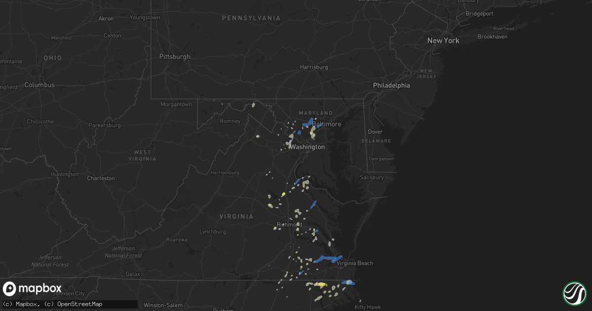
Hail Map in Maryland on June 22, 2020
Get this storm
June 22 map
$229
one time, instant access
Download today. No call, no setup
Keep the $229
Bought the map and want the full workflow? Apply the entire $229 to a subscription within 7 days. None of it is wasted.
Every map, not just this one
This buys you this map. Subscription and you get every map we run, in the markets you choose from a few cities to whole states to nationwide. Plus real-time alerts the moment a storm fires.
Contact data
Name, contact info, occupancy, even credit band for addresses in the footprint. You go from where it hit to who to call.
Become the source they trust
Unlimited branding weather history reports on demand. You already have the documented answer ready for the property owner, and you are the one who showed up with it.
Property data and RoofTrace estimates
Pull up any address you have got, its value and the exact code rules for that jurisdiction, straight from One Click Code. Then RoofTrace estimates the squares, pitch, and roof value, priced the way you price.
Storm reports in Maryland
Maryland
| Date | Description |
|---|---|
| 06/22/20206:12 PM CDT | Severeal trees down in saint leonard. |
| 06/22/20205:25 PM CDT | Tree down on i-695 baltimore beltway near cromwell bridge road. |
| 06/22/20205:22 PM CDT | Tree down on md-88 black rock road near benson mill road. |
| 06/22/20204:50 PM CDT | Downed tree near conway st and charles st |
| 06/22/20204:49 PM CDT | Tree down on md-88 black rock road near benson mill road. |
| 06/22/20204:47 PM CDT | Tree down on md-88 black rock road near benson mill road. |
| 06/22/20204:45 PM CDT | Numerous trees down in and near ellicott south to near columbia. One tree fell on and destroyed a house. |
| 06/22/20204:40 PM CDT | Tree down on i-83 northbound prior to exit 17/padonia road. |
| 06/22/20204:38 PM CDT | Tree down on i-695 baltimore beltway outer loop near md-122 security boulevard. |
| 06/22/20204:29 PM CDT | Tree down on i-70 westbound at us-29 columbia pike. |
| 06/22/20204:25 PM CDT | Tree down on i-695 baltimore beltway near cromwell bridge road. |
| 06/22/20204:15 PM CDT | Quarter size hail in west laurel. |
| 06/22/20204:15 PM CDT | Tree down on us-29 columbia pike at md-216 lime kiln road. |
| 06/22/20204:15 PM CDT | Trees down in huntingtown. |
| 06/22/20204:15 PM CDT | Severeal trees down in saint leonard. |
| 06/22/20203:57 PM CDT | Tree down on us-40 near turf valley road. |
| 06/22/20203:49 PM CDT | Downed tree on the 23400 block of budds creek rd |
| 06/22/20203:45 PM CDT | Multiple trees down along budds creek road in clements. |
| 06/22/20203:45 PM CDT | Multiple trees down along budds creek road in clements. |
| 06/22/20203:38 PM CDT | Trees and wires down in the kensington area. A tree fell on a car on the capital beltway |
| 06/22/20203:31 PM CDT | A local report indicates 63 MPH wind near 5 S SWAN POINT |
| 06/22/20203:28 PM CDT | Tree down on md-109 near peach tree road. |
| 06/22/20203:28 PM CDT | Tree down on us-301 near rosewick road. |
| 06/22/20203:25 PM CDT | Multiple trees down along us-301 in southern charles county. |
| 06/22/20203:20 PM CDT | Reports of trees down on md-80 fingerboard road near park mills road. |
| 06/22/20203:18 PM CDT | Multiple trees down in the gaithersburg area. |
| 06/22/20203:18 PM CDT | Wires down on veirs mill road near atlantic avenue. |
| 06/22/20203:12 PM CDT | A local report indicates 58 MPH wind near 3 ENE DAHLGREN |
| 06/22/20203:10 PM CDT | A local report indicates 66 MPH wind near 3 ESE DAHLGREN |
| 06/22/20202:42 PM CDT | Tree down on creek road. |
| 06/22/20202:41 PM CDT | Trees down near the intersection of pipe creek road and stern road. |
| 06/22/20202:00 PM CDT | Tree down on md-80 fingerboard road near singleton drive. Several other trees and large branches down in a half mile radius. |
| 06/22/202012:42 PM CDT | Severeal trees and wires down near spring gap. |
| 06/22/20202:25 AM CDT | At 724 PM EDT, a severe thunderstorm was located over Charlestown, or 7 miles west of Elkton, moving north at 15 mph. HAZARD...60 mph wind gusts and quarter size hail. SOURCE...Radar indicated. IMPACT...Minor damage to vehicles is possible. Wind damage to roofs, siding, trees, and power lines is possible. Locations impacted include... Newark, Elkton, Calvert, Oxford, North East, Rising Sun, Charlestown, Homeville, Glen Roy, Zion, Blake, Barksdale, Glasgow, Bear, West Nottingham, Brantwood, Mount Vernon, Fair Hill, Glen Westover and Bay View.This includes the following highways... Interstate 95 in Delaware between mile markers 0 and 4. Interstate 95 in Maryland between mile markers 92 and 109. |
| 06/22/20201:11 AM CDT | At 611 PM EDT, a severe thunderstorm was located over Pikesville, moving northeast at 30 mph. HAZARD...60 mph wind gusts. SOURCE...Radar indicated. IMPACT...Damaging winds will cause some trees and large branches to fall. This could injure those outdoors, as well as damage homes and vehicles. Roadways may become blocked by downed trees. Localized power outages are possible. Unsecured light objects may become projectiles. Locations impacted include... Baltimore, Pikesville, Cockeysville, Towson, Randallstown, Parkville, Bel Air North, Carney, Milford Mill, Lochearn, Mays Chapel, Timonium, Fallston, Hampton, Jarrettsville, Lutherville-Timonium, Garrison, Lutherville, Long Green and Riderwood. |
| 06/22/202012:33 AM CDT | At 533 PM EDT, a severe thunderstorm was located 7 miles southeast of Taylors Island, moving northeast at 25 mph. HAZARD...60 mph wind gusts and quarter size hail. SOURCE...Radar indicated. IMPACT...Minor damage to vehicles is possible. Expect wind damage to trees and powerlines. This severe thunderstorm will be near, Cambridge around 600 PM EDT. Vienna around 615 PM EDT.Other locations impacted by this severe thunderstorm include ChurchCreek, Bucktown, Woolford and Linkwood. |
| 06/22/202012:30 AM CDT | At 530 PM EDT, a severe thunderstorm was located over Woodlawn, or near Historic Ellicott City, moving northeast at 40 mph. HAZARD...60 mph wind gusts and quarter size hail. SOURCE...Radar indicated. IMPACT...Damaging winds will cause some trees and large branches to fall. This could injure those outdoors, as well as damage homes and vehicles. Roadways may become blocked by downed trees. Localized power outages are possible. Unsecured light objects may become projectiles. Locations impacted include... Baltimore, Pikesville, Cockeysville, Elkridge, Historic Ellicott City, Ellicott City, Towson, Catonsville, Woodlawn, Randallstown, Parkville, Owings Mills, Carney, Milford Mill, Perry Hall, Lochearn, Arbutus, Mays Chapel, Timonium and Hampton. |
| 06/22/202012:00 AM CDT | At 500 PM EDT, a severe thunderstorm was located over Beltsville, moving north at 20 mph. HAZARD...60 mph wind gusts and quarter size hail. SOURCE...Radar indicated. IMPACT...Damaging winds will cause some trees and large branches to fall. This could injure those outdoors, as well as damage homes and vehicles. Roadways may become blocked by downed trees. Localized power outages are possible. Unsecured light objects may become projectiles. Locations impacted include... Columbia, Severn, Olney, College Park, Greenbelt, Beltsville, Elkridge, Baltimore-Washington Airport, Historic Ellicott City, Ellicott City, Aspen Hill, Catonsville, Odenton, Laurel, Fairland, Arbutus, Ferndale, Colesville, Brooklyn Park and Fort Meade. |
| 06/21/202011:49 PM CDT | At 448 PM EDT, severe thunderstorms were located along a line extending from 6 miles east of La Plata to near Wicomico River to Saint Clements Bay, moving northeast at 35 mph. This storm has a history of producing up to 70 mph winds and downed trees. HAZARD...70 mph wind gusts. SOURCE...Radar indicated. IMPACT...Damaging winds will cause some trees and large branches to fall. This could injure those outdoors, as well as damage homes and vehicles. Roadways may become blocked by downed trees. Localized power outages are possible. Unsecured light objects may become projectiles. Locations impacted include... Chesapeake Ranch Estates, Chesapeake Beach, Prince Frederick, Cuckold Creek, Sheridan Point, Calvert Cliffs, Greenwell State Park, Hallowing Point, Saint Leonard Creek, Breezy Point, Flag Harbor, Lusby, Saint Leonard, Huntingtown, Drum Point, Owings, Long Beach, Aquasco, Calvert Beach and Benedict. |
| 06/21/202011:31 PM CDT | At 431 PM EDT, severe thunderstorms were located along a line extending from near Saint Clements Bay to Tall Timbers to near Saint George Island, moving northeast at 30 mph. HAZARD...60 mph wind gusts and quarter size hail. SOURCE...Radar indicated. IMPACT...Damaging winds will cause some trees and large branches to fall. This could injure those outdoors, as well as damage homes and vehicles. Roadways may become blocked by downed trees. Localized power outages are possible. Unsecured light objects may become projectiles. Locations impacted include... Lexington Park, Chesapeake Ranch Estates, Leonardtown, Piney Point, Tall Timbers, Saint Inigoes Creek, Saint Marys City, Saint George Island, Calvert Cliffs, Greenwell State Park, Saint Clements Bay, Town Creek, Wicomico River, Saint Marys River, Flag Harbor, White Point Beach, California, Patuxent River Naval Air Station, Hollywood and Drum Point. |
| 06/21/202011:27 PM CDT | At 426 PM EDT, a severe thunderstorm was located near Popes Creek, moving northeast at 25 mph. HAZARD...60 mph wind gusts. SOURCE...Radar indicated. IMPACT...Damaging winds will cause some trees and large branches to fall. This could injure those outdoors, as well as damage homes and vehicles. Roadways may become blocked by downed trees. Localized power outages are possible. Unsecured light objects may become projectiles. Locations impacted include... Sheridan Point, Hallowing Point, Golden Beach, Wicomico, Hughesville, Mechanicsville, Charlotte Hall, Bryantown, Benedict, Rock Point, Issue, Tompkinsville, Chaptico, Sandgates, Bel Alton, Swan Point, Faulkner, Loveville, Morganza and Dentsville. |
| 06/21/202011:14 PM CDT | At 414 PM EDT, a severe thunderstorm was located over Ballenger Creek, or over Harry Grove Stadium, moving northeast at 25 mph. HAZARD...60 mph wind gusts and quarter size hail. SOURCE...Radar indicated. IMPACT...Damaging winds will cause some trees and large branches to fall. This could injure those outdoors, as well as damage homes and vehicles. Roadways may become blocked by downed trees. Localized power outages are possible. Unsecured light objects may become projectiles. Locations impacted include... Frederick, Thurmont, Harry Grove Stadium, Ballenger Creek, Walkersville, Braddock Heights, New Market, Clover Hill, Discovery-Spring Garden, Linganore-Bartonsville, Adamstown, Woodsboro, Buckeystown, Libertytown, New Midway, Park Mills, Utica, Unionville, Graceham and Lewistown. |
| 06/21/202011:12 PM CDT | At 412 PM EDT, severe thunderstorms were located along a line extending from near Poolesville to near Potomac, moving northeast at 30 mph. HAZARD...60 mph wind gusts and quarter size hail. SOURCE...Radar indicated. IMPACT...Damaging winds will cause some trees and large branches to fall. This could injure those outdoors, as well as damage homes and vehicles. Roadways may become blocked by downed trees. Localized power outages are possible. Unsecured light objects may become projectiles. Locations impacted include... Germantown, Rockville, Gaithersburg, Olney, Damascus, Ellicott City, Aspen Hill, Potomac, North Bethesda, Montgomery Village, Eldersburg, North Potomac, Redland, Mount Airy, Sykesville, New Market, Boyds, Green Valley, Rossmoor and Linganore-Bartonsville. |
| 06/21/202010:53 PM CDT | At 353 PM EDT, a severe thunderstorm was located near King George, moving northeast at 20 mph. HAZARD...60 mph wind gusts and quarter size hail. SOURCE...Radar indicated. IMPACT...Damaging winds will cause some trees and large branches to fall. This could injure those outdoors, as well as damage homes and vehicles. Roadways may become blocked by downed trees. Localized power outages are possible. Unsecured light objects may become projectiles. Locations impacted include... King George, Dahlgren, Nanjemoy Creek, Swan Point, Weedonville, Ninde and Berthaville. |
| 06/21/202010:45 PM CDT | At 345 PM EDT, a severe thunderstorm was located near Leesburg, moving north at 30 mph. HAZARD...60 mph wind gusts and quarter size hail. SOURCE...Radar indicated. IMPACT...Damaging winds will cause some trees and large branches to fall. This could injure those outdoors, as well as damage homes and vehicles. Roadways may become blocked by downed trees. Localized power outages are possible. Unsecured light objects may become projectiles. Locations impacted include... Frederick, Leesburg, Harry Grove Stadium, Ballenger Creek, Brunswick, Walkersville, Braddock Heights, Clover Hill, Point Of Rocks, Adamstown, Jefferson, Myersville, Buckeystown, Rosemont, Burkittsville, Doubs, Utica, Petersville, Bolivar and Lewistown. |
| 06/21/202010:44 PM CDT | At 343 PM EDT, severe thunderstorms were located along a line extending from Fairview Beach to near Colonial Beach, moving northeast at 15 mph. HAZARD...60 mph wind gusts. SOURCE...Radar indicated. IMPACT...Damaging winds will cause some trees and large branches to fall. This could injure those outdoors, as well as damage homes and vehicles. Roadways may become blocked by downed trees. Localized power outages are possible. Unsecured light objects may become projectiles. Locations impacted include... La Plata, Nanjemoy Creek, Popes Creek, Port Tobacco River, Wicomico River, Wicomico, Bryans Road, Mechanicsville, Charlotte Hall, Cobb Island, Potomac Heights, Pomfret, Rock Point, Port Tobacco Village, Bushwood, Clements, Issue, Potomac Beach, Tompkinsville and Chaptico. |
| 06/21/202010:41 PM CDT | At 341 PM EDT, severe thunderstorms were located along a line extending from near Saint Stephens Church to Millers Tavern, moving northeast at 40 mph. HAZARD...60 mph wind gusts and penny size hail. SOURCE...Radar indicated. IMPACT...Expect damage to trees and powerlines. Severe thunderstorms will be near, Tappahannock and Dunnsville around 350 PM EDT. Champlain around 355 PM EDT. Warsaw and Newland around 400 PM EDT. Haynesville around 405 PM EDT. Montross around 410 PM EDT. Hague and Kinsale around 415 PM EDT. Coles Point around 420 PM EDT.Other locations impacted by these severe thunderstorms includeCurrioman Landing, Threeway, Mount Holly, Upright, Biscoe, StratfordHall, Lyells, Crouch, Kennard and Westmoreland. |
| 06/21/202010:22 PM CDT | At 322 PM EDT, a severe thunderstorm was located near Fort A.p. Hill, or 9 miles north of Bowling Green, moving northeast at 30 mph. HAZARD...60 mph wind gusts and quarter size hail. SOURCE...Radar indicated. IMPACT...Damaging winds will cause some trees and large branches to fall. This could injure those outdoors, as well as damage homes and vehicles. Roadways may become blocked by downed trees. Localized power outages are possible. Unsecured light objects may become projectiles. Locations impacted include... King George, Dahlgren, Nanjemoy Creek, Potomac Beach, Rollins Fork, Weedonville, Ninde, Lambs Creek, Berthaville, Jersey, Shiloh and Dogue. |
| 06/21/20209:39 PM CDT | At 239 PM EDT, a severe thunderstorm was located near Green Valley, or near Damascus, moving north at 15 mph. HAZARD...60 mph wind gusts and quarter size hail. SOURCE...Radar indicated. IMPACT...Damaging winds will cause some trees and large branches to fall. This could injure those outdoors, as well as damage homes and vehicles. Roadways may become blocked by downed trees. Localized power outages are possible. Unsecured light objects may become projectiles. Locations impacted include... Germantown, Frederick, Ballenger Creek, Mount Airy, Walkersville, New Market, Discovery-Spring Garden, Boyds, Green Valley, Linganore-Bartonsville, Clarksburg, Libertytown, Monrovia, Barnesville, Ijamsville, Mount Pleasant, Park Mills, Dickerson and Beallsville. |
| 06/21/20208:14 PM CDT | At 114 PM EDT, a severe thunderstorm was located 8 miles northeast of Romney, moving northeast at 25 mph. HAZARD...60 mph wind gusts and quarter size hail. SOURCE...Radar indicated. IMPACT...Damaging winds will cause some trees and large branches to fall. This could injure those outdoors, as well as damage homes and vehicles. Roadways may become blocked by downed trees. Localized power outages are possible. Unsecured light objects may become projectiles. Locations impacted include... Paw Paw, Springfield, Green Spring, Flintstone, Oldtown, Little Orleans, Three Churches, Higginsville, Fishers Bridge, Pumpkin Center, Magnolia, Slanesville, Points, Levels and Green Ridge. |
All States Impacted by Hail Map on June 22, 2020
Cities Impacted by Hail Map on June 22, 2020
- Aliceville, AL
- Perryton, TX
- Ansley, NE
- Lubbock, TX
- Wilson, TX
- Brownfield, TX
- Jacksonville, NC
- Milford, NE
- Silverton, TX
- Boise City, OK
- Stratford, TX
- Boswell, PA
- Ligonier, PA
- Laughlintown, PA
- Mullin, TX
- Sugar Land, TX
- Canadian, TX
- Odessa, TX
- Fordyce, NE
- Crofton, NE
- Lorenzo, TX
- Galesburg, IL
- East Galesburg, IL
- Knoxville, IL
- Cameron, IL
- Monmouth, IL
- Mechanicsville, VA
- Richmond, VA
- Bumpass, VA
- Mineral, VA
- Ewing, NE
- Perrin, TX
- Jacksboro, TX
- Bridgeport, TX
- Dublin, TX
- Gustine, TX
- Channing, TX
- Vega, TX
- Ozona, TX
- Cordell, OK
- Sentinel, OK
- Spearman, TX
- Brownwood, TX
- Melrose, NM
- Wildorado, TX
- Clayton, NM
- Brady, TX
- Rochelle, TX
- Richland Springs, TX
- Charles City, VA
- Comanche, TX
- Stinnett, TX
- Panhandle, TX
- Dumas, TX
- Cactus, TX
- Fritch, TX
- Amarillo, TX
- Borger, TX
- Sunray, TX
- Texhoma, OK
- Masterson, TX
- Columbia, NC
- Oviedo, FL
- Winter Springs, FL
- Casselberry, FL
- San Angelo, TX
- Clearwater, NE
- Henrietta, MO
- Lexington, MO
- Richmond, MO
- Goldsmith, TX
- Berkeley Springs, WV
- Midland, TX
- Big Lake, TX
- Versailles, IL
- Griggsville, IL
- Chambersburg, IL
- Kenney, IL
- Latham, IL
- Chestnut, IL
- Colonial Beach, VA
- King George, VA
- Moseley, VA
- Powhatan, VA
- Midlothian, VA
- Mertzon, TX
- Higgins, TX
- Leesburg, VA
- Hanover, VA
- Old Glory, TX
- Spur, TX
- Aspermont, TX
- Stephenville, TX
- Houston, TX
- Pearland, TX
- Graford, TX
- Hartington, NE
- Rocky, OK
- Whiteface, TX
- Parkston, SD
- Delmont, SD
- Rochester, TX
- Weinert, TX
- Henrico, VA
- Gates, NC
- Corapeake, NC
- Eure, NC
- Sunbury, NC
- Gatesville, NC
- Evant, TX
- Memphis, MO
- Saint Martinville, LA
- Grosse Tete, LA
- Haines City, FL
- Lake Wales, FL
- Hennepin, IL
- Putnam, IL
- Pawhuska, OK
- Bartlesville, OK
- Netawaka, KS
- Powhattan, KS
- Ramah, CO
- Morrisonville, IL
- Pawnee, IL
- Carrollton, MO
- Elberton, GA
- Dewy Rose, GA
- Wichita Falls, TX
- Foss, OK
- Moorefield, WV
- Orlando, FL
- Crown Point, IN
- Spencer, NE
- Maywood, IL
- Melrose Park, IL
- River Forest, IL
- Bellwood, IL
- River Grove, IL
- Elmwood Park, IL
- Petersburg, TX
- Rising Star, TX
- Cisco, TX
- Amherst, TX
- Purcellville, VA
- Hamilton, VA
- Rosenberg, TX
- Richmond, TX
- May, TX
- Cross Plains, TX
- Early, TX
- Vintondale, PA
- Homer City, PA
- Tripp, SD
- Kings Mountain, NC
- Bessemer City, NC
- Breckenridge, TX
- Knotts Island, NC
- Moyock, NC
- Arnett, OK
- Hebron, IN
- Graham, TX
- Olney, TX
- Loving, TX
- Goldthwaite, TX
- Garden City, TX
- Hallam, NE
- Girard, IL
- Henrietta, TX
- Holliday, TX
- Mingus, TX
- Frankfort, IL
- Manhattan, IL
- Stromsburg, NE
- Osceola, NE
- De Leon, TX
- Pierce, NE
- Osmond, NE
- Dalhart, TX
- New Lenox, IL
- Monee, IL
- Elwood, IL
- Joliet, IL
- King William, VA
- Mcalester, OK
- Ropesville, TX
- Meadow, TX
- Fluvanna, TX
- Carlsbad, TX
- Hayes, VA
- Old Fields, WV
- Warrensburg, IL
- Maroa, IL
- Williamston, NC
- Ranger, TX
- Tuscola, IL
- Fairbury, NE
- Carrsville, VA
- Windsor, NC
- Merkel, TX
- Tuscola, TX
- Liberty, TX
- Cleveland, TX
- McVeytown, PA
- Burtonsville, MD
- Fulton, MD
- Spencerville, MD
- Levelland, TX
- Pep, TX
- Cortland, NE
- Pickrell, NE
- Adams, NE
- Hart, TX
- Romney, WV
- Wakefield, VA
- Goodwell, OK
- Fairfax, OK
- Shattuck, OK
- Harpers Ferry, WV
- Quinton, VA
- Sandston, VA
- Andrews, TX
- Wingate, TX
- Winters, TX
- Gruver, TX
- Martell, NE
- Durham, OK
- Follett, TX
- Chantilly, VA
- Centreville, VA
- Fairfax, VA
- Herndon, VA
- Sterling, VA
- Providence Forge, VA
- Gotebo, OK
- Dimmitt, TX
- Nazareth, TX
- Haskell, TX
- Rule, TX
- Avoca, TX
- Stamford, TX
- Electra, TX
- Spotsylvania, VA
- Okeechobee, FL
- Moore Haven, FL
- Tulsa, OK
- Sand Springs, OK
- Capitan, NM
- Carlton, TX
- Hamilton, TX
- Culpeper, VA
- Immokalee, FL
- Hobart, IN
- Merrillville, IN
- Ralston, OK
- Lockney, TX
- Dayton, TX
- Hartley, TX
- Sterling City, TX
- Batavia, NY
- Gardendale, TX
- Hobart, OK
- Bowie, TX
- Slaton, TX
- Courtland, VA
- Mount Pulaski, IL
- Stanton, TX
- Johnson, VT
- Hyde Park, VT
- Randolph, NE
- Mclean, NE
- Mountain View, OK
- Gresham, NE
- Lanexa, VA
- Albany, TX
- Blum, TX
- Throckmorton, TX
- Strawn, TX
- Hico, TX
- Creswell, NC
- Kress, TX
- Hobbsville, NC
- Tyner, NC
- Booker, TX
- Crete, NE
- Pesotum, IL
- Yankton, SD
- Baileyville, KS
- Powells Point, NC
- Jarvisburg, NC
- East Waterford, PA
- Blairs Mills, PA
- Orbisonia, PA
- Newport News, VA
- Yorktown, VA
- Laurinburg, NC
- Channahon, IL
- Wilmington, IL
- Morris, IL
- Maxton, NC
- Tahoka, TX
- Wolfforth, TX
- Blandinsville, IL
- Newburg, MD
- Red Springs, NC
- Shannon, NC
- Raeford, NC
- Arcadia, FL
- Littlefield, TX
- Enning, SD
- Lowland, NC
- Farmersville, IL
- Tovey, IL
- Kincaid, IL
- Bulpitt, IL
- Skippers, VA
- Garysburg, NC
- Whiting, KS
- Beltsville, MD
- Tappahannock, VA
- Abilene, TX
- Atkinson, NE
- Stony Creek, VA
- Yale, VA
- Waverly, VA
- Aurora, NC
- Newsoms, VA
- Franklin, VA
- Labelle, FL
- Granville, IL
- McNabb, IL
- Lueders, TX
- Frostburg, MD
- Indian Lake Estates, FL
- Camden, NC
- South Mills, NC
- Sudan, TX
- Gatesville, TX
- Haymarket, VA
- Gainesville, VA
- Emporia, VA
- Camp Lejeune, NC
- Silver Creek, NE
- Waggoner, IL
- Mcalister, NM
- Cleburne, TX
- Hardesty, OK
- Balko, OK
- Ohiowa, NE
- Strang, NE
- Disputanta, VA
- Rhome, TX
- Newark, TX
- Boyd, TX
- Springtown, TX
- Quitaque, TX
- Cairo, GA
- Thomasville, GA
- Decatur, IL
- Bedford, IA
- New Market, IA
- Clarinda, IA
- Como, NC
- Blue Mound, IL
- Sedley, VA
- Odonnell, TX
- Jamesville, NC
- Plymouth, NC
- Sweetwater, TX
- Montpelier, VA
- Halifax, NC
- Roanoke Rapids, NC
- Crosby, TX
- Denton, NE
- Pleasant Dale, NE
- Morton, TX
- Enochs, TX
- Huntingdon, PA
- Petersburg, PA
- Clarks, NE
- Kissimmee, FL
- Strongstown, PA
- Twin Rocks, PA
- Ebensburg, PA
- Lone Wolf, OK
- Rappahannock Academy, VA
- Washington, NC
- Stokes, NC
- Greenville, NC
- Camden, SC
- Berkeley, IL
- Elmhurst, IL
- Genoa, NE
- Columbus, NE
- Table Rock, NE
- Gaithersburg, MD
- Suffolk, VA
- Gordon, TX
- Holley, NY
- Murfreesboro, NC
- Eufaula, OK
- Roper, NC
- Brookesmith, TX
- Star, TX
- Pavilion, NY
- Glenarm, IL
- Divernon, IL
- Good Hope, GA
- Monroe, GA
- Mason, TX
- Kahoka, MO
- Wayland, MO
- Firth, NE
- Weatherford, TX
- Adamstown, MD
- Macon, GA
- Ruther Glen, VA
- Woodford, VA
- Sedalia, MO
- Wellsville, NY
- Mokena, IL
- Brookeville, MD
- Dayton, MD
- Glenelg, MD
- Waterford, VA
- Silver Spring, MD
- Wagon Mound, NM
- Newcastle, TX
- Weldon, NC
- Jonesville, LA
- Jenks, OK
- Niantic, IL
- Petersburg, VA
- Gail, TX
- Alexandria, NE
- Tobias, NE
- Utica, NE
- Devers, TX
- Beaumont, TX
- Roca, NE
- Paradise, TX
- Poolville, TX
- Babson Park, FL
- Macomb, IL
- Sciota, IL
- Beaverdam, VA
- Woodson, TX
- Canton, GA
- Trent, TX
- Christoval, TX
- Scranton, NC
- Belhaven, NC
- Richland, GA
- Schererville, IN
- Griffith, IN
- Maysville, NC
- Hobbs, NM
- Lovington, NM
- Byron, NY
- Barnsdall, OK
- Elizabeth City, NC
- New Bern, NC
- Randallstown, MD
- Woodstock, MD
- Georgetown, SC
- Geddes, SD
- Cerro Gordo, IL
- Argenta, IL
- Platte, SD
- Shelby, NC
- Grover, NC
- Henryetta, OK
- Poolesville, MD
- Lipscomb, TX
- Livingston, AL
- Spring, TX
- Williamsburg, VA
- Trementina, NM
- Canyon, TX
- Happy, TX
- Hertford, NC
- Belvidere, NC
- Ovalo, TX
- Argyle, IA
- Farmington, IA
- Sturgis, SD
- Boyds, MD
- Dickerson, MD
- Barnesville, MD
- Mission Hill, SD
- Utica, SD
- White Post, VA
- Winchester, VA
- Buena Vista, GA
- Claude, TX
- Rosharon, TX
- Alvin, TX
- Locust Grove, VA
- Needville, TX
- Dexter, KS
- Alberta, VA
- Laurel, MD
- Missouri City, TX
- Filley, NE
- Dill City, OK
- Prue, OK
- Stevensburg, VA
- Elkwood, VA
- Hominy, OK
- Mounds, OK
- Bixby, OK
- Georgetown, DE
- Bridgeville, DE
- Stafford, TX
- Fisher, WV
- Post, TX
- Lake Placid, FL
- Mora, MO
- Snyder, TX
- Bristow, OK
- Naperville, IL
- Lisle, IL
- Addison, IL
- Wheaton, IL
- Lombard, IL
- Glen Ellyn, IL
- Bensenville, IL
- Wood Dale, IL
- Villa Park, IL
- Downers Grove, IL
- Gaston, NC
- Justiceburg, TX
- Ivor, VA
- Miami, TX
- Roy, NM
- Nolan, TX
- Norfolk, NE
- Peru, IL
- Kenansville, FL
- Glenpool, OK
- Kiefer, OK
- Winter Park, FL
- Quanah, TX
- Stephens City, VA
- Doss, TX
- Harper, TX
- Campo, CO
- Capron, VA
- Caddo, TX
- Aldie, VA
- Geneva, NE
- Frostproof, FL
- Watson, AR
- Fredericksburg, VA
- Pollocksville, NC
- Frederick, MD
- Tulia, TX
- Huffman, TX
- Seymour, TX
- Miles, TX
- Belle Glade, FL
- Walkerton, VA
- Saint Stephens Church, VA
- Bruington, VA
- Winton, NC
- Ahoskie, NC
- Verdigre, NE
- Gary, IN
- Valparaiso, IN
- Port Royal, VA
- Clarksville, MD
- Columbia, MD
- Highland, MD
- Ellicott City, MD
- Ashton, MD
- Colerain, NC
- Harrellsville, NC
- Hammon, OK
- Channelview, TX
- Luray, MO
- Plains, TX
- Tokio, TX
- Newville, PA
- Gordo, AL
- Smicksburg, PA
- Gastonia, NC
- Barry, IL
- Ochopee, FL
- Skiatook, OK
- South Bay, FL
- Clewiston, FL
- Braddyville, IA
- Haslet, TX
- Stonington, IL
- Danville, IA
- Niles, MI
- Dowagiac, MI
- Barnhart, TX
- Daykin, NE
- Manquin, VA
- Aylett, VA
- Sadorus, IL
- Charlotte, NC
- Hereford, TX
- Taylorville, IL
- Edinburg, IL
- Virden, IL
- Harvel, IL
- Aledo, TX
- Bellaire, TX
- Boykins, VA
- Bowen, IL
- Grantsville, MD
- Branchville, VA
- Dry Branch, GA
- Toano, VA
- Bishop, GA
- Chesapeake, VA
- Carrollton, VA
- Zuni, VA
- Smithfield, VA
- Windsor, VA
- Warsaw, VA
- Dunnsville, VA
- Great Falls, VA
- Portsmouth, VA
- Norfolk, VA
- Wayside, TX
- Lakeview, TX
- Hedley, TX
- Memphis, TX
- Lelia Lake, TX
- Wellington, TX
- Tell, TX
- Clarendon, TX
- Childress, TX
- Groom, TX
- Earth, TX
- Muleshoe, TX
- Olton, TX
- Friona, TX
- Springlake, TX
- Plainview, TX
- Fieldton, TX
- Hale Center, TX
- Shallowater, TX
- Smyer, TX
- Ackerly, TX
- Hermleigh, TX
- Welch, TX
- Tarzan, TX
- Lenorah, TX
- Lamesa, TX
- Ira, TX
- Colorado City, TX
- Westbrook, TX
- Moran, TX
- Clyde, TX
- Lawn, TX
- O'Brien, TX
- Baird, TX
- McAdenville, NC
- Mount Holly, NC
- Belmont, NC
- Cramerton, NC
- Lowell, NC
- Dansville, NY
- Coleridge, NE
- Clarkson, NE
- Howells, NE
- Scribner, NE
- North Bend, NE
- Cedar Bluffs, NE
- Ames, NE
- Dodge, NE
- Clatonia, NE
- Crab Orchard, NE
- Henry, IL
- Franklin Park, IL
- Hillside, IL
- Des Plaines, IL
- Arlington Heights, IL
- Elk Grove Village, IL
- Matteson, IL
- Richton Park, IL
- Auburn, IL
- Texhoma, TX
- Keyes, OK
- Farwell, TX
- Sundown, TX
- Maple, TX
- Dickens, TX
- Paducah, TX
- New London, IA
- Bourg, LA
- Theriot, LA
- Raceland, LA
- Lockport, LA
- Houma, LA
- Gheens, LA
- Tallulah, LA
- Solano, NM
- Clovis, NM
- Rogers, NM
- Portales, NM
- Ijamsville, MD
- Montgomery Village, MD
- Cooksville, MD
- Woodbine, MD
- Marriottsville, MD
- Sykesville, MD
- West Friendship, MD
- Glenwood, MD
- Gwynn Oak, MD
- Baltimore, MD
- Catonsville, MD
- Mangum, OK
- Honea Path, SC
- Belton, SC


