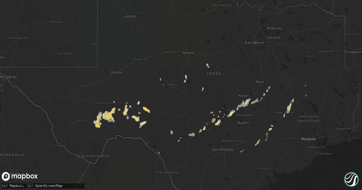
Hail Map in Texas on June 21, 2021
Get this storm
June 21 map
$229
one time, instant access
Download today. No call, no setup
Keep the $229
Bought the map and want the full workflow? Apply the entire $229 to a subscription within 7 days. None of it is wasted.
Every map, not just this one
This buys you this map. Subscription and you get every map we run, in the markets you choose from a few cities to whole states to nationwide. Plus real-time alerts the moment a storm fires.
Contact data
Name, contact info, occupancy, even credit band for addresses in the footprint. You go from where it hit to who to call.
Become the source they trust
Unlimited branding weather history reports on demand. You already have the documented answer ready for the property owner, and you are the one who showed up with it.
Property data and RoofTrace estimates
Pull up any address you have got, its value and the exact code rules for that jurisdiction, straight from One Click Code. Then RoofTrace estimates the squares, pitch, and roof value, priced the way you price.
Storm reports in Texas
Texas
| Date | Description |
|---|---|
| 06/21/20216:13 AM CDT | At 1113 PM CDT, a severe thunderstorm was located over Horseshoe Bay, or near Round Mountain, moving south at 10 mph. HAZARD...70 mph wind gusts and penny size hail. SOURCE...Radar indicated. IMPACT...Expect considerable tree damage. Damage is likely to mobile homes, roofs, and outbuildings. Locations impacted include... Marble Falls, Round Mountain, Granite Shoals, Horseshoe Bay, Johnson City, Meadowlakes, Stonewall, Spicewood, Blowout, Sandy, LBJ State Park, Rocky Creek, Hye, Cypress Mill, Henly, Pedernales Falls State Park, Cottonwood Shores, Sunrise Beach Village and LBJ National Historical Park. |
| 06/21/20215:35 AM CDT | At 1035 PM CDT, a severe thunderstorm was located near Smithwick, or 11 miles south of Bertram, moving south at 25 mph. HAZARD...60 mph wind gusts and quarter size hail. SOURCE...Radar indicated. IMPACT...Hail damage to vehicles is expected. Expect wind damage to roofs, siding, and trees. Locations impacted include... Lakeway, Lago Vista, Hudson Bend, The Hills, Spicewood, Cypress Mill, Smithwick, Jonestown, Briarcliff and Point Venture. |
| 06/21/20214:25 AM CDT | At 925 PM CDT, a severe thunderstorm was located 13 miles northwest of Juno, moving southwest at 25 mph. HAZARD...60 mph wind gusts and quarter size hail. SOURCE...Radar indicated. IMPACT...Hail damage to vehicles is expected. Expect wind damage to roofs, siding, and trees. Locations impacted include... Pandale. |
| 06/21/20214:20 AM CDT | Gonzales emc reported wind damage at the 1715 cr 283 location. Pictures show both roof and metal building damage and broken branches of large trees. |
| 06/21/20214:04 AM CDT | At 903 PM CDT, a severe thunderstorm was located 13 miles east of Terrell County Gas Plant, moving southeast at 20 mph. HAZARD...Ping pong ball size hail and 60 mph wind gusts. SOURCE...Radar indicated. IMPACT...People and animals outdoors will be injured. Expect hail damage to roofs, siding, windows, and vehicles. Expect wind damage to roofs, siding, and trees. This severe thunderstorm will remain over mainly rural areas of south central Crockett County. |
| 06/21/20213:19 AM CDT | At 819 PM CDT, a severe thunderstorm was located over Ozona, moving south at 15 mph. HAZARD...60 mph wind gusts and quarter size hail. SOURCE...Radar indicated. IMPACT...Hail damage to vehicles is expected. Expect wind damage to roofs, siding, and trees. This severe thunderstorm will remain over mainly rural areas of southeastern Crockett County, including the following locations... The Intersection Of Highway 163 And Ranch Road 1973.This includes Interstate 10 between Mile Markers 354 and 372. |
| 06/21/20212:25 AM CDT | A trained spotter reported tree damage and broken tree limbs just west of round top near the intersection of weyand road and round top road. Time of the damage is estim |
| 06/21/20212:03 AM CDT | At 702 PM CDT, a severe thunderstorm was located 14 miles east of Chinati Mountains, or 21 miles north of Presidio, moving south at 25 mph. HAZARD...60 mph wind gusts and half dollar size hail. SOURCE...Radar indicated. IMPACT...Hail damage to vehicles is expected. Expect wind damage to roofs, siding, and trees. Locations impacted include... Presidio, Big Bend Ranch State Park, Shafter, Casa Piedra and Presidio Lely International Airport. |
| 06/21/202112:35 AM CDT | Trees down near fm 244 and sh 30. |
| 06/21/202112:08 AM CDT | Trees down near sh90 and fm 141 near bedias. |
| 06/21/202112:08 AM CDT | Mesonet station bdtt2 bird. |
| 06/20/202110:50 PM CDT | There was widespread wind damage to mainly trees reported in southern burnet county. A nws damage survey has concluded that a large swath of severe thunderstorm microbu |
All States Impacted by Hail Map on June 21, 2021
Cities Impacted by Hail Map on June 21, 2021
- Mount Pleasant, AR
- Marlin, TX
- Madisonville, TX
- Ledbetter, TX
- Round Top, TX
- Compton, AR
- Green Forest, AR
- Berryville, AR
- Alpena, AR
- Chestertown, MD
- Worton, MD
- Boone, NC
- Blowing Rock, NC
- Babson Park, FL
- Lake Wales, FL
- Jackman, ME
- Fort Stockton, TX
- Marathon, TX
- Berryville, VA
- Bluemont, VA
- Salado, TX
- Paint Rock, TX
- Rowena, TX
- Falls Of Rough, KY
- Fredericksburg, TX
- Colebrook, NH
- Tamaqua, PA
- Coaldale, PA
- Nesquehoning, PA
- Chambersburg, PA
- Greencastle, PA
- Paris, TN
- Cottage Grove, TN
- Puryear, TN
- Knob Lick, KY
- Glasgow, KY
- Grantsville, WV
- Summersville, WV
- Craigsville, WV
- Kerrville, TX
- Allardt, TN
- Jamestown, TN
- Winfield, WV
- Scott Depot, WV
- Wilcox, PA
- Ferrisburgh, VT
- Harrisburg, PA
- Bristol, VT
- Waitsfield, VT
- Starksboro, VT
- Dorset, OH
- Andover, OH
- Jefferson, OH
- Iola, TX
- Bedias, TX
- Everton, AR
- Hudson Falls, NY
- Florence, TX
- Cortland, NY
- Freeville, NY
- Bernhards Bay, NY
- Cleveland, NY
- Rogersville, TN
- Thorn Hill, TN
- Sneedville, TN
- Mooresburg, TN
- Sparta, TN
- Jersey Shore, PA
- Poca, WV
- Hurricane, WV
- Red House, WV
- Saint Albans, WV
- Nitro, WV
- Charleston, WV
- Ozona, TX
- Muncy Valley, PA
- Forksville, PA
- Dushore, PA
- Stonewall, TX
- Edinburg, VA
- Marble Falls, TX
- Spicewood, TX
- Vincent, KY
- Booneville, KY
- Tuttle, OK
- Blanchard, OK
- Orwell, OH
- Bardstown, KY
- Coxs Creek, KY
- Boston, KY
- Shepherdsville, KY
- Leitchfield, KY
- Hornersville, MO
- Llano, TX
- Dryden, TX
- Ballinger, TX
- Piseco, NY
- Lake Pleasant, NY
- Wellington, KY
- Frenchburg, KY
- Dallas, WV
- Wheeling, WV
- Moundsville, WV
- Belton, TX
- Fulton, KY
- McKee, KY
- Williamsfield, OH
- Rome, OH
- Liberty Hill, TX
- Rockwood, TN
- Harriman, TN
- Waelder, TX
- Flatonia, TX
- Gonzales, TX
- Shiner, TX
- Mcminnville, TN
- Quebeck, TN
- Crossville, TN
- Walling, TN
- Smithville, TN
- Rock Island, TN
- Doyle, TN
- Bolivar, NY
- Shinglehouse, PA
- Ceres, NY
- Alma, NY
- Little Genesee, NY
- Eldred, PA
- Wellsville, NY
- Herndon, PA
- Gratz, PA
- Klingerstown, PA
- Lykens, PA
- Reno, OH
- Newport, OH
- Marietta, OH
- Williamstown, WV
- Whipple, OH
- Rising Star, TX
- Johnson City, TX
- Orrtanna, PA
- Middlebury, VT
- North Ferrisburgh, VT
- New Haven, VT
- Vergennes, VT
- Ponca, AR
- Iraan, TX
- Shelbyville, TN
- Tipton, OK
- Martinsville, OH
- Lynchburg, OH
- Hillsboro, OH
- Midland, OH
- New Vienna, OH
- Fenwick, WV
- Campbellsville, KY
- Homer, NY
- Cub Run, KY
- Mammoth Cave, KY
- Durhamville, NY
- Portville, NY
- Hopkinsville, KY
- Reagan, TX
- Crab Orchard, TN
- Cairo, WV
- Rochelle, TX
- Belleville, WV
- Mineral Wells, WV
- Danville, AR
- Waynesburg, KY
- Murfreesboro, TN
- Kissimmee, FL
- Bonnieville, KY
- Magnolia, KY
- Brownsville, KY
- Bowling Green, KY
- Sweetwater, TN
- Niota, TN
- Headrick, OK
- Kenansville, FL
- Comstock, TX
- Ozark, AR
- Ratcliff, AR
- Cold Brook, NY
- Lebanon, KY
- Jarrell, TX
- Schroon Lake, NY
- North Hudson, NY
- Granville, NY
- Boyce, VA
- College Station, TX
- Smethport, PA
- Groton, NY
- Fairfield, PA
- Kenton, TN
- Spencer, NY
- Van Etten, NY
- Cayuta, NY
- Erin, NY
- Jamestown, KY
- Burkesville, KY
- Rockport, WV
- Ravenswood, WV
- Rocksprings, TX
- Fort Pierce, FL
- North Zulch, TX
- Anderson, TX
- Troy, NY
- Burnet, TX
- Danville, PA
- Sunbury, PA
- Bloomfield, KY
- Horseshoe Bay, TX
- Ashland, ME
- Mountain View, AR
- Beaver Dam, KY
- Dawson Springs, KY
- Elkview, WV
- Summersville, KY
- Yellville, AR
- Alicia, AR
- Walnut Ridge, AR
- Melrose, NY
- Mechanicville, NY
- Schaghticoke, NY
- Queensbury, NY
- Fort Ann, NY
- Sebring, FL
- Hartstown, PA
- Conneaut Lake, PA
- Atlantic, PA
- Taberg, NY
- Crab Orchard, KY
- Stanford, KY
- Holland, TX
- Temple, TX
- Rogers, TX
- Lovelady, TX
- Schulenburg, TX
- Leander, TX
- Bertram, TX
- Big Bend, WV
- Normantown, WV
- Glenville, WV
- Arnoldsburg, WV
- Big Springs, WV
- Dunbar, WV
- South Charleston, WV
- Fraziers Bottom, WV
- Eleanor, WV
- Ezel, KY
- Saint Cloud, FL
- Thurmont, MD
- Rocky Ridge, MD
- Rome, NY
- Blossvale, NY
- Canastota, NY
- Oneida, NY
- Triadelphia, WV
- Valley Grove, WV
- Pioneer, TN
- Oneida, TN
- Navasota, TX
- Willow City, TX
- Clinton, KY
- South Fulton, TN
- Grapeland, TX
- Crockett, TX
- Nixon, TX
- Caribou, ME
- Fort Fairfield, ME
- West Liberty, KY
- Elkfork, KY
- Carmine, TX
- Burton, TX
- Daytona Beach, FL
- Ormond Beach, FL
- Sharon, TN
- Martin, TN
- Munfordville, KY
- Rocky Top, TN
- Clinton, TN
- Barksdale, TX
- Mapleton, ME
- Clarkson, KY
- Moriah, NY
- Port Henry, NY
- Crown Point, NY
- Lancing, TN
- Wartburg, TN
- Sheffield, TX
- Rosebud, TX
- Burlington, TX
- Stanton, KY
- Round Mountain, TX
- Ferguson, NC
- La Follette, TN
- Carlsbad, TX
- West Alexander, PA
- Claysville, PA
- Camden, NY
- Constantia, NY
- Ava, NY
- Lee Center, NY
- Waynesboro, PA
- Olustee, OK
- Mangum, OK
- Duke, OK
- Altus, OK
- Ingram, TX
- Helenwood, TN
- Robbins, TN
- Manila, AR
- Lott, TX
- Elmer, OK
- Frederick, OK
- May, TX
- Tazewell, TN
- Oliver Springs, TN
- Sharpsburg, MD
- Keedysville, MD
- Coolville, OH
- Guysville, OH
- Stewart, OH
- Athens, OH
- Cutler, OH
- McKenzie, TN
- Henry, TN
- Gleason, TN
- Purlear, NC
- Deep Gap, NC
- Fort Valley, VA
- Mayfield, KY
- Del Rio, TX
- Bell Buckle, TN
- La Grange, TX
- Little York, NY
- Preble, NY
- Vanderpool, TX
- Leakey, TX
- Eubank, KY
- Science Hill, KY
- Ithaca, NY
- Mechanicstown, OH
- Carrollton, OH
- Windsor, OH
- Wingo, KY
- Water Valley, KY
- Prairie Grove, AR
- Lithia, FL
- Mulberry, FL
- Plant City, FL
- Trout Run, PA
- Liberty, PA
- Morgantown, WV
- Fairmont, WV
- Morrison, TN
- Mount Enterprise, TX
- Princeton, KY
- Trenton, FL
- Bangor, PA
- Mount Bethel, PA
- Columbia, NJ
- Albany, KY
- Monticello, KY
- Alpha, KY
- Kings Mountain, KY
- Dyer, TN
- Reedsville, OH
- Walker, WV
- Elizabeth, WV
- Port Saint Lucie, FL
- Buchanan Dam, TX
- Killeen, TX
- Georgetown, TX
- Blossburg, PA
- Morris, PA
- Eidson, TN
- Round Hill, VA
- Harpers Ferry, WV
- Athens, AL
- Leesville, TX
- Meadville, PA
- Cochranton, PA
- Delbarton, WV
- Logan, WV
- North Wilkesboro, NC
- McGrady, NC
- Caneyville, KY
- Grantville, PA
- Annville, PA
- Brodhead, KY
- Kattskill Bay, NY
- Lake George, NY
- Middleburg, VA
- Marshall, VA
- The Plains, VA
- Roundhill, KY
- Bee Spring, KY
- Waverly, WV
- Leachville, AR
- Camp Wood, TX
- Hardinsburg, KY
- Hunt, TX
- Richford, NY
- Marathon, NY
- Adamsville, PA
- Jamestown, PA
- Cromwell, KY
- Horse Branch, KY
- Morgantown, KY
- Huntington, AR
- Mansfield, AR
- Washburn, ME
- Beaver Dams, NY
- Linesville, PA
- Salineville, OH
- White Post, VA
- Front Royal, VA
- Strasburg, VA
- Upperville, VA
- Stephens City, VA
- Winchester, VA
- Paris, VA
- Leesburg, VA
- Middletown, VA
- Purcellville, VA
- Guildhall, VT
- Errol, NH
- Lakeland, FL
- Waco, KY
- Richmond, KY
- Irvine, KY
- Winchester, KY
- Clay City, KY
- Caryville, TN
- Huntsville, TN
- New Market, TN
- Oak Ridge, TN
- Knoxville, TN
- Mascot, TN
- Luttrell, TN
- Powell, TN
- Blaine, TN
- Strawberry Plains, TN
- Heiskell, TN
- Corryton, TN
- Tully, NY
- De Ruyter, NY
- Whitehall, NY
- Palestine, WV
- Calvin, WV
- Carthage, NY
- Natural Bridge, NY
- Harrisville, NY
- Castorland, NY
- Lowville, NY
- Croghan, NY
- Caledonia, NY
- Lakeville, NY
- Minetto, NY
- Farmington, NY
- North Rose, NY
- Macedon, NY
- Mendon, NY
- Piffard, NY
- Sterling, NY
- York, NY
- Altmar, NY
- Retsof, NY
- Wolcott, NY
- Honeoye Falls, NY
- Lima, NY
- Pulaski, NY
- Le Roy, NY
- Marion, NY
- Hannibal, NY
- Leicester, NY
- Walworth, NY
- Rush, NY
- Martville, NY
- Ionia, NY
- Lyons, NY
- Fairport, NY
- Livonia, NY
- Williamson, NY
- Pavilion, NY
- Fulton, NY
- Avon, NY
- Victor, NY
- Wyoming, NY
- Mexico, NY
- Pittsford, NY
- Palmyra, NY
- Bloomfield, NY
- Red Creek, NY
- Shortsville, NY
- Sodus Point, NY
- Richland, NY
- Sodus, NY
- Geneseo, NY
- West Bloomfield, NY
- Linwood, NY
- Newark, NY
- Oswego, NY
- Island Pond, VT
- Saint Johnsbury, VT
- Danville, VT
- Concord, VT
- Littleton, NH
- East Liverpool, OH
- Industry, PA
- Lisbon, OH
- Midland, PA
- Wellsville, OH
- Hammondsville, OH
- Apollo, PA
- Beaver, PA
- Penn Run, PA
- Mars, PA
- Bairdford, PA
- Homer City, PA
- Tarentum, PA
- Conway, PA
- Blairsville, PA
- Northern Cambria, PA
- Dilltown, PA
- Natrona Heights, PA
- Leechburg, PA
- Josephine, PA
- Cheswick, PA
- Hyde Park, PA
- Saltsburg, PA
- Avonmore, PA
- Twin Rocks, PA
- Warrendale, PA
- Wexford, PA
- Strongstown, PA
- Nicktown, PA
- Bakerstown, PA
- Nanty Glo, PA
- Cranberry Township, PA
- Belsano, PA
- Colver, PA
- East Vandergrift, PA
- Armagh, PA
- Indiana, PA
- Russellton, PA
- Coral, PA
- Monaca, PA
- New Kensington, PA
- Brackenridge, PA
- Freedom, PA
- Creighton, PA
- Carrolltown, PA
- Vintondale, PA
- Clune, PA
- Gibsonia, PA
- North Apollo, PA
- Clarksburg, PA
- Valencia, PA
- Baden, PA
- Vandergrift, PA
- Brush Valley, PA
- Ebensburg, PA
- Shelocta, PA
- Spring Church, PA
- Irwin, PA
- Adamsburg, PA
- Jeannette, PA
- Westmoreland City, PA
- Larimer, PA
- Rillton, PA
- Herminie, PA
- Pleasant Unity, PA
- West Newton, PA
- New Stanton, PA
- Arona, PA
- Greenock, PA
- Madison, PA
- Ruffs Dale, PA
- Homestead, PA
- North Versailles, PA
- Dravosburg, PA
- Youngwood, PA
- Duquesne, PA
- Mount Pleasant, PA
- Darragh, PA
- West Mifflin, PA
- Latrobe, PA
- Glassport, PA
- Pittsburgh, PA
- Hunker, PA
- Greensburg, PA
- Mckeesport, PA
- Yukon, PA
- Bellefonte, PA
- Avis, PA
- Lock Haven, PA
- Howard, PA
- Julian, PA
- Blanchard, PA
- Mill Hall, PA
- Beech Creek, PA
- Williamsport, PA
- Linden, PA
- Towanda, PA
- Monroeton, PA
- New Albany, PA


