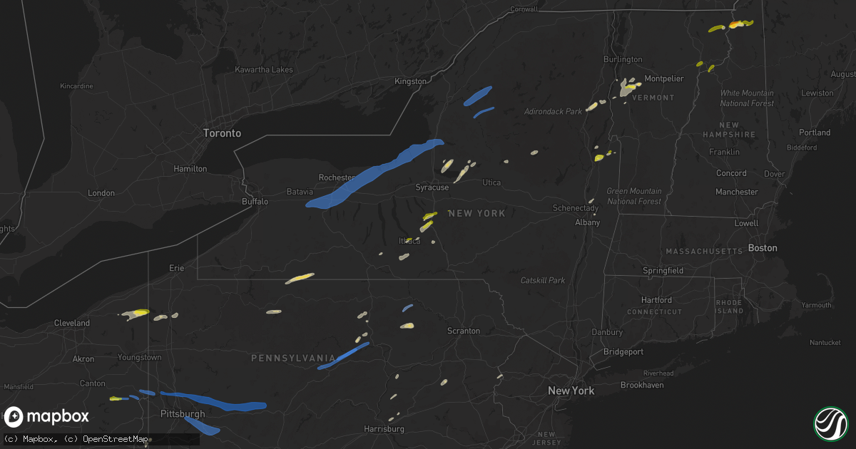
Hail Map on June 21, 2021
Get this storm
June 21 map
$229
one time, instant access
Download today. No call, no setup
Keep the $229
Bought the map and want the full workflow? Apply the entire $229 to a subscription within 7 days. None of it is wasted.
Every map, not just this one
This buys you this map. Subscription and you get every map we run, in the markets you choose from a few cities to whole states to nationwide. Plus real-time alerts the moment a storm fires.
Contact data
Name, contact info, occupancy, even credit band for addresses in the footprint. You go from where it hit to who to call.
Become the source they trust
Unlimited branding weather history reports on demand. You already have the documented answer ready for the property owner, and you are the one who showed up with it.
Property data and RoofTrace estimates
Pull up any address you have got, its value and the exact code rules for that jurisdiction, straight from One Click Code. Then RoofTrace estimates the squares, pitch, and roof value, priced the way you price.
States Impacted by Hail Map on June 21, 2021
Storm reports
North Carolina
| Date | Description |
|---|---|
| 06/21/20216:40 PM CDT | County dispatch confirmed multiple trees and powerlines down across parts of swain county. |
| 06/21/20216:24 PM CDT | Tree down on boone trail and parsonsville road. |
| 06/21/20216:08 PM CDT | Tree down along boone trail. Time estimated by radar. |
| 06/21/20215:55 PM CDT | Multiple trees reported down in hayes area. |
| 06/21/20211:50 AM CDT | At 649 PM EDT, a severe thunderstorm was located over Hays, or near Traphill, moving east at 40 mph. HAZARD...60 mph wind gusts and quarter size hail. SOURCE...Radar indicated. IMPACT...Hail damage to vehicles is expected. Expect wind damage to roofs, siding, and trees. Locations impacted include... North Wilkesboro... Elkin... Wilkesboro... Fairview... Jonesville... Dobson... and Boonville. |
| 06/21/20211:50 AM CDT | At 649 PM EDT, severe thunderstorms were located along a line extending from 10 miles southwest of Maryville to 10 miles east of Etowah, moving east at 30 mph. HAZARD...60 mph wind gusts. SOURCE...Radar indicated. IMPACT...Expect damage to roofs, siding, and trees. Locations impacted include... Maryville, Smoky Mountains-Twentymile Creek, Smoky Mountains-Fontana Area, Vonore, Tellico Plains, Townsend, Fort Loudon State Park, Tariffville, McGee Carson Peninsula and Walland. |
| 06/21/20211:29 AM CDT | At 627 PM EDT, a severe thunderstorm was located near Deep Gap, moving northeast at 20 mph. Additional strong storms were located near Summit and Wilbar. HAZARD...60 mph wind gusts and quarter size hail. SOURCE...Radar indicated. IMPACT...Hail damage to vehicles is expected. Expect wind damage to roofs, siding, and trees. Locations impacted include... North Wilkesboro... Wilkesboro... Laurel Springs... Glendale Springs... Wilbar... Deep Gap... and Mc Grady. |
| 06/21/202112:43 AM CDT | At 543 PM EDT, a severe thunderstorm was located over Sands, or over Boone, moving northeast at 30 mph. HAZARD...60 mph wind gusts and quarter size hail. SOURCE...Radar indicated. IMPACT...Hail damage to vehicles is expected. Expect wind damage to roofs, siding, and trees. Locations impacted include... Boone... West Jefferson... Glendale Springs... Wilbar... Deep Gap... Todd... and Rutherwood.This includes The following Location Appalachian State University. |
| 06/20/20218:15 PM CDT | Tree down on red white and blue rd in the roaring river area. |
| 06/20/20217:50 PM CDT | Tree down on hwy 16 near alexander county line. |
Tennessee
| Date | Description |
|---|---|
| 06/21/20216:42 PM CDT | Several trees down near the rockwood area. |
| 06/21/20216:35 PM CDT | Numerous trees and powerlines down throughout the county... Rockwood area hit the hardest. |
| 06/21/20216:17 PM CDT | Several trees down in the crab orchard community |
| 06/21/20216:13 PM CDT | Trees down across the area. |
| 06/21/20216:12 PM CDT | Several trees down across the county. |
| 06/21/20216:06 PM CDT | Report from mping: 1-inch tree limbs broken; shingles blown off. |
| 06/21/20216:04 PM CDT | Several trees down along lantana rd |
| 06/21/20215:36 PM CDT | Large tree down on sr 285 |
| 06/21/20215:35 PM CDT | Several trees down across northern monroe county. |
| 06/21/20215:34 PM CDT | Large tree down on scotts gulf road |
| 06/21/20215:25 PM CDT | Large tree down on north robin hood rd. |
| 06/21/20215:18 PM CDT | Several trees down near the clairfield area. |
| 06/21/20215:17 PM CDT | Several trees down across the county. |
| 06/21/20215:12 PM CDT | Severe trees down. |
| 06/21/20215:07 PM CDT | A few trees down. |
| 06/21/20214:51 PM CDT | A few trees down. |
| 06/21/20214:51 PM CDT | Report from mping: 1-inch tree limbs broken; shingles blown off. |
| 06/21/20214:50 PM CDT | Numerous trees down across north knox county. |
| 06/21/20214:50 PM CDT | Tree down along mcminnville hwy |
| 06/21/20214:47 PM CDT | A few trees down and minor metal roofing damage in pulaski. |
| 06/21/20214:29 PM CDT | Few trees down. |
| 06/21/20214:28 PM CDT | Several trees down across the south end of the county. |
| 06/21/20214:25 PM CDT | Scattered to numerous trees down throughout the county in addition to downed powerlines. |
| 06/21/20214:24 PM CDT | Couple trees down. |
| 06/21/20214:15 PM CDT | A few trees down. |
| 06/21/20214:09 PM CDT | A few trees down. |
| 06/21/20214:08 PM CDT | A local report indicates 1.50 inch wind near 3 N TREADWAY |
| 06/21/20213:45 PM CDT | A few trees down. |
| 06/21/20213:14 PM CDT | A few trees down in the livingston area. |
| 06/21/20212:44 PM CDT | Tree blown down across a powerline. |
| 06/21/20212:25 PM CDT | Trees down in parts of the county including hwy 47 in charlotte and cumberland furnace. |
| 06/21/20212:20 PM CDT | Facebook report showed a destroyed shed in tennessee city. |
| 06/21/20212:41 AM CDT | At 741 PM EDT, a severe thunderstorm was located over Midtown, or near Rockwood, moving east at 45 mph. HAZARD...60 mph wind gusts and nickel size hail. SOURCE...Radar indicated. IMPACT...Expect damage to roofs, siding, and trees. Locations impacted include... Knoxville, Oak Ridge, Maryville, Clinton, Lenoir City, Alcoa, Kingston, Loudon, Farragut and Oliver Springs.This includes the following highways... Interstate 40 in Tennessee between mile markers 358 and 386. Interstate 75 in Tennessee between mile markers 76 and 123. |
| 06/21/20212:31 AM CDT | At 729 PM EDT, severe thunderstorms were located along a line extending from 15 miles southeast of Maryville to 11 miles northwest of Murphy, moving east at 30 mph. HAZARD...60 mph wind gusts. SOURCE...Radar indicated. IMPACT...Expect damage to trees and power lines. Locations impacted include... Robbinsville, Town Of Santeetlah, Lake Santeetlah, Fontana Lake, Fontana Village, Stecoah, Nantahala, and a portion of the Smoky Mountains, near Newfound Gap, Twentymile Creek, and in the Fontana Area. |
| 06/21/20212:19 AM CDT | At 719 PM EDT, a severe thunderstorm was located 7 miles south of Fairfield Glade, or 9 miles southeast of Crossville, moving east at 25 mph. HAZARD...60 mph wind gusts and nickel size hail. SOURCE...Radar indicated. IMPACT...Expect damage to roofs, siding, and trees. Locations impacted include... Oak Ridge, Kingston, Rockwood, Fairview, Midtown, Harriman, Oakdale, Coalfield, Eagle Furnace and Pine Orchard.This includes Interstate 40 in Tennessee between mile markers 341 and358. |
| 06/21/20211:54 AM CDT | At 653 PM EDT, a severe thunderstorm was located near Louisville, or near Alcoa, moving east at 20 mph. HAZARD...60 mph wind gusts and penny size hail. SOURCE...Radar indicated. IMPACT...Expect damage to roofs, siding, and trees. Locations impacted include... Knoxville, Maryville, Alcoa, Pigeon Forge, Louisville, Rockford, Eagleton Village, Friendsville, Kimberlin Heights and Wildwood.This includes Interstate 40 in Tennessee between mile markers 378 and389, and between mile markers 400 and 406. |
| 06/21/20211:02 AM CDT | At 601 PM EDT, severe thunderstorms were located along a line extending from 7 miles west of New Tazewell to 6 miles southwest of Rutledge to New Market to 9 miles north of Sevierville to 8 miles east of Knoxville, moving east at 45 mph. HAZARD...60 mph wind gusts and penny size hail. SOURCE...Radar indicated. IMPACT...Expect damage to roofs, siding, and trees. Locations impacted include... Morristown, Greeneville, Jefferson City, Newport, Rogersville, Dandridge, Rutledge, Bean Station, White Pine and New Market.This includes the following highways... Interstate 40 in Tennessee between mile markers 410 and 435. Interstate 81 in Tennessee between mile markers 1 and 34. |
| 06/21/202112:57 AM CDT | At 557 PM CDT, a severe thunderstorm was located near Crossville, moving east at 40 mph. HAZARD...60 mph wind gusts. SOURCE...Radar indicated. IMPACT...Expect damage to roofs, siding, and trees. Locations impacted include... Crossville, Fairfield Glade, Crab Orchard, Pleasant Hill, Lake Tansi, Cumberland Mountain State Park, Slate Springs and Indian Rock Lake.This includes Interstate 40 between mile markers 306 and 339. |
| 06/21/202112:42 AM CDT | At 541 PM EDT, a severe thunderstorm was located 8 miles south of Zion Hill, or 9 miles northwest of La Follette, moving east at 45 mph. HAZARD...60 mph wind gusts and quarter size hail. SOURCE...Radar indicated. IMPACT...Hail damage to vehicles is expected. Expect wind damage to roofs, siding, and trees. Locations impacted include... Harrogate, Jellico, Elk Valley, Cumberland Gap, Arthur, Indian Mountain State Park, Clairfield and White Oak.This includes Interstate 75 in Tennessee between mile markers 142 and161. |
| 06/21/202112:36 AM CDT | At 536 PM EDT, a severe thunderstorm was located near Clinton, moving east at 40 mph. HAZARD...60 mph wind gusts and nickel size hail. SOURCE...Radar indicated. IMPACT...Expect damage to roofs, siding, and trees. Locations impacted include... Knoxville, Jefferson City, New Market, Strawberry Plains, Halls, Blaine, Maloneyville, Mascot, Piedmont and Powell.This includes the following highways... Interstate 40 in Tennessee between mile markers 389 and 405, andbetween mile markers 410 and 413. Interstate 75 in Tennessee between mile markers 108 and 114. |
| 06/21/202112:29 AM CDT | At 528 PM EDT, a severe thunderstorm was located 7 miles northeast of Clinton, moving east at 40 mph. HAZARD...60 mph wind gusts and penny size hail. SOURCE...Radar indicated. IMPACT...Expect damage to roofs, siding, and trees. Locations impacted include... Maynardville, Rutledge, Plainview, Halls, Blaine, Luttrell, Rose Hill, Buffalo Springs, Paulette and Big Ridge State Park.This includes Interstate 75 in Tennessee between mile markers 114 and117. |
| 06/21/202112:22 AM CDT | At 522 PM CDT, a severe thunderstorm was located 9 miles northwest of Spencer, moving east at 40 mph. HAZARD...60 mph wind gusts. SOURCE...Radar indicated. IMPACT...Expect damage to roofs, siding, and trees. Locations impacted include... McMinnville, Sparta, Spencer, Pleasant Hill, Doyle, Fall Creek Falls State Park, Indian Rock Lake, Virgin Falls State Natural Area and Rock Island State Park. |
| 06/21/202112:17 AM CDT | At 517 PM EDT, a severe thunderstorm was located near Fonde, or near Middlesboro, moving east at 35 mph. HAZARD...60 mph wind gusts. SOURCE...Radar indicated. IMPACT...Expect damage to roofs, siding, and trees. This severe thunderstorm will be near... Middlesboro around 525 PM EDT. Binghamtown around 530 PM EDT.Other locations in the path of this severe thunderstorm includeHutch. |
| 06/21/202112:05 AM CDT | At 504 PM EDT, a severe thunderstorm was located 10 miles southwest of Helenwood, or 13 miles southeast of Jamestown, moving east at 45 mph. HAZARD...70 mph wind gusts and nickel size hail. SOURCE...Radar indicated. IMPACT...Expect considerable tree damage. Damage is likely to mobile homes, roofs, and outbuildings. Locations impacted include... Oneida, Huntsville, Helenwood, Rugby, Elk Valley, Rugby State Park, Honey Creek State Park, Royal Blue, Norma and Elgin.This includes Interstate 75 in Tennessee between mile markers 143 and151. |
| 06/20/202111:55 PM CDT | At 454 PM EDT, a severe thunderstorm was located 7 miles east of Wartburg, moving northeast at 35 mph. HAZARD...60 mph wind gusts and penny size hail. SOURCE...Radar indicated. IMPACT...Expect damage to roofs, siding, and trees. Locations impacted include... Oak Ridge, Clinton, La Follette, Wartburg, Oliver Springs, Jacksboro, Harriman, Caryville, Rocky Top and Norris.This includes Interstate 75 in Tennessee between mile markers 118 and142. |
| 06/20/202111:44 PM CDT | At 444 PM CDT, a severe thunderstorm was located near Woodbury, moving east at 40 mph. HAZARD...60 mph wind gusts. SOURCE...Radar indicated. IMPACT...Expect damage to roofs, siding, and trees. Locations impacted include... McMinnville, Woodbury, Centertown and Rock Island State Park. |
| 06/20/202111:29 PM CDT | At 428 PM EDT, a severe thunderstorm was located 8 miles east of Fairfield Glade, or 9 miles southwest of Wartburg, moving northeast at 35 mph. HAZARD...60 mph wind gusts and nickel size hail. SOURCE...Radar indicated. IMPACT...Expect damage to roofs, siding, and trees. Locations impacted include... Wartburg, Sunbright, Oakdale, Coalfield, Pine Orchard, Frozen Head State Park and Petros. |
| 06/20/202110:40 PM CDT | At 339 PM CDT, a severe thunderstorm was located 9 miles southwest of Jamestown, moving east at 45 mph. HAZARD...60 mph wind gusts. SOURCE...Radar indicated. IMPACT...Expect damage to roofs, siding, and trees. Locations impacted include... Jamestown, Allardt, Crawford and Grimsley. |
| 06/20/20219:38 PM CDT | At 237 PM CDT, a severe thunderstorm was located 7 miles east of Carthage, moving northeast at 45 mph. HAZARD...60 mph wind gusts. SOURCE...Radar indicated. IMPACT...Expect damage to roofs, siding, and trees. Locations impacted include... Livingston, Carthage, Celina, Gainesboro, Whitleyville, Granville, Cummins Falls State Park and Standing Stone State Park.This includes Interstate 40 near mile marker 266. |
| 06/20/20219:36 PM CDT | At 235 PM CDT, a severe thunderstorm was located 8 miles west of Ashland City, moving east at 40 mph. HAZARD...60 mph wind gusts. SOURCE...Radar indicated. IMPACT...Expect damage to roofs, siding, and trees. Locations impacted include... Ashland City, Nashville, Goodlettsville, Forest Hills, Oak Hill, White Bluff, Belle Meade, Kingston Springs, Pegram, Joelton, Pleasant View, Berry Hill, Cheatham Dam, Bells Bend, Whites Creek and Beaman Park.This includes the following highways... Interstate 40 between mile markers 197 and 213. Interstate 65 between mile markers 77 and 93. Interstate 24 between mile markers 29 and 53. |
| 06/20/20219:05 PM CDT | At 205 PM CDT, severe thunderstorms were located along a line extending from 13 miles east of Erin to near Waverly, moving east at 30 mph. HAZARD...60 mph wind gusts. SOURCE...Radar indicated. IMPACT...Expect damage to roofs, siding, and trees. Locations impacted include... Dickson, Waverly, Erin, McEwen, Burns, Charlotte, Vanleer, Slayden and Cheatham Dam. |
| 06/20/20219:04 PM CDT | At 204 PM CDT, a severe thunderstorm was located near Watertown, or 11 miles southeast of Lebanon, moving northeast at 40 mph. HAZARD...60 mph wind gusts. SOURCE...Radar indicated. IMPACT...Expect damage to roofs, siding, and trees. Locations impacted include... Lebanon, Carthage, Watertown, Gordonsville, Hickman, South Carthage, Alexandria, Cedars Of Lebanon State Park, Center Hill Lake, Tuckers Crossroads and Edgar Evans State Park.This includes Interstate 40 between mile markers 241 and 266. |
| 06/20/20217:05 PM CDT | Tree down on campbell station rd and powerlines down on guinn rd. |
Nevada
| Date | Description |
|---|---|
| 06/20/202110:30 PM CDT | Mesonet station mjbn2 majuba station elevation: 5292 ft. |
South Carolina
| Date | Description |
|---|---|
| 06/21/202112:29 AM CDT | At 528 PM EDT, a severe thunderstorm was located 11 miles south of Downtown Greenville, or near Donaldson Center, moving northeast at 25 mph. HAZARD...60 mph wind gusts and quarter size hail. SOURCE...Radar indicated. IMPACT...Minor hail damage to vehicles is expected. Expect wind damage to trees and power lines. Locations impacted include... Mauldin, Simpsonville, Five Forks, Fountain Inn, Woodruff, Reidville, Donaldson Center, Fork Shoals and Piedmont. |
New York
| Date | Description |
|---|---|
| 06/21/20216:55 PM CDT | Wires down on county route 1 in putnam. |
| 06/21/20216:50 PM CDT | Tree across road. |
| 06/21/20216:42 PM CDT | Trees across the road. |
| 06/21/20216:40 PM CDT | Tree blocking road. |
| 06/21/20216:28 PM CDT | Trees down near route 8 in lake pleasant town center. |
| 06/21/20216:12 PM CDT | Trees and wires down. |
| 06/21/20216:07 PM CDT | Trees down |
| 06/21/20216:04 PM CDT | Multiple trees down |
| 06/21/20215:35 PM CDT | All lanes on route 28 in old forge are blocked between crosby blvd and adams st due to wires down |
| 06/21/20215:35 PM CDT | Trees and wires down. Time estimated from radar. |
| 06/21/20215:31 PM CDT | Report of trees down |
| 06/21/20215:27 PM CDT | Tree down across road. |
| 06/21/20215:24 PM CDT | Trees and wires down across stony lake road. |
| 06/21/20215:17 PM CDT | Tree down on wire. |
| 06/21/20215:16 PM CDT | Trees down near pine grove rd and eatonville rd. And at gregg rd and brantingham rd. |
| 06/21/20215:14 PM CDT | Trees down on blue st. |
| 06/21/20215:14 PM CDT | Multiple trees down on pine grove rd near schoolhouse rd. Power poles blown down on barnes rd. |
| 06/21/20215:11 PM CDT | Trees down on seymore ave... And on shibley rd. |
| 06/21/20215:10 PM CDT | Lewis county dispatch reports widespread reports of storm damage... Primarily downed trees and powerlines... Across the county. This includes the towns of lowville... L |
| 06/21/20215:09 PM CDT | Trees down on marmon rd near penney settlement rd. |
| 06/21/20215:09 PM CDT | Trees down on e main st. |
| 06/21/20215:07 PM CDT | Tree and wires down on state route 22a in granville. |
| 06/21/20215:05 PM CDT | Trees and wires down. Also in marathon and virgil. Time estimated from radar. |
| 06/21/20215:05 PM CDT | Approximately 5 trees down... One fell on garage causing roof damage. Chicken coops heavily damaged or destroyed. Time is estimated by radar. |
| 06/21/20215:03 PM CDT | Trees and wires down on lincoln st and trees down on domser rd. |
| 06/21/20214:50 PM CDT | Tree and wires down on cross and butler road intersection. |
| 06/21/20214:49 PM CDT | A tornado touched down in yellow barn state forest... East of yellow barn road. It then tracked eastward and struck a farm on irish settlement road... Snapping and upro |
| 06/21/20214:48 PM CDT | Several trees down along midline road. Some wires. Radar estimate. |
| 06/21/20214:48 PM CDT | A couple of trees down. |
| 06/21/20214:47 PM CDT | Trees down on wire blocking road. |
| 06/21/20214:45 PM CDT | Large tree down on wires. |
| 06/21/20214:43 PM CDT | Several trees snapped. Also trees on wires and several large branches down in the area. Time estimated from radar. |
| 06/21/20214:40 PM CDT | Trees and wires down in middle granville. |
| 06/21/20214:40 PM CDT | Trees down on rt 26. |
| 06/21/20214:40 PM CDT | Tree down on road. |
| 06/21/20214:38 PM CDT | Trees and wires down on fisher settlement road. |
| 06/21/20214:37 PM CDT | Tree down on wires. |
| 06/21/20214:35 PM CDT | Trees and wires down heather ln... Rowena dr... Sherwood dr. |
| 06/21/20214:30 PM CDT | Trees and wires down. |
| 06/21/20214:30 PM CDT | Tree and wires down south road in hampton. |
| 06/21/20214:27 PM CDT | Tree down on wires. |
| 06/21/20214:25 PM CDT | Trees and wires down in hampton near route 22a. |
| 06/21/20214:25 PM CDT | Trees and wires down in kingsbury. |
| 06/21/20214:25 PM CDT | Trees and wires down. |
| 06/21/20214:25 PM CDT | Tree on power lines on bardin rd in kingsbury. |
| 06/21/20214:19 PM CDT | Large tree down on west seneca street. |
| 06/21/20214:15 PM CDT | Trees and wires down. |
| 06/21/20214:14 PM CDT | Measured asos wind gust. |
| 06/21/20214:10 PM CDT | Tree and wires down on lands end way in dresden. |
| 06/21/20214:05 PM CDT | Tree down across roadway. Corrected time |
| 06/21/20214:03 PM CDT | Tree uprooted. |
| 06/21/20213:57 PM CDT | Large tree down across road. |
| 06/21/20213:56 PM CDT | Tree and wires down near route 9n. |
| 06/21/20213:55 PM CDT | Multiple large trees down. Time radar estimated. |
| 06/21/20213:54 PM CDT | Tree down across road. |
| 06/21/20213:53 PM CDT | Trees and wires down in bolton landing. |
| 06/21/20213:45 PM CDT | Tree and wires down. |
| 06/21/20213:45 PM CDT | Tree across roadway on county route 1. |
| 06/21/20213:42 PM CDT | Multiple trees and wires down in vicinity of lee street and south street. Road is blocked. |
| 06/21/20213:40 PM CDT | Trees and wires down near route 8 and 9n. |
| 06/21/20213:39 PM CDT | Multiple reports of tress down in the city of geneva. |
| 06/21/20213:39 PM CDT | Large trees and wires down. Time estimated from radar. |
| 06/21/20213:26 PM CDT | Trees down including trees on power lines in the town of lyons. |
| 06/21/20213:20 PM CDT | Trees and power lines down. Time estimated from radar. |
| 06/21/20213:15 PM CDT | Tree down on wires. Power pole snapped. |
| 06/21/20213:15 PM CDT | A local report indicates 1.00 inch wind near DERUYTER |
| 06/21/20213:12 PM CDT | Trees down into a creek. |
| 06/21/20213:10 PM CDT | Tree down on trailer on quaker road. |
| 06/21/20213:07 PM CDT | Tree down on south shore rd |
| 06/21/20213:02 PM CDT | Trees down on fishers road near i-90. |
| 06/21/20213:01 PM CDT | Multiple reports of trees down including trees on power lines. |
| 06/21/20213:00 PM CDT | A house on duncott road near highway 31 had a tree cut into the front of the house. |
| 06/21/20213:00 PM CDT | Multiple reports of trees down on several roads. One on a house. |
| 06/21/20212:58 PM CDT | Tree down on wires near route 31 and 36. |
| 06/21/20212:58 PM CDT | Significant tree damage on i-490 at route 96 in bushnells basin. |
| 06/21/20212:58 PM CDT | Half dozen trees blown down or uprooted. A few trees were snapped off 20-25 feet above ground. |
| 06/21/20212:57 PM CDT | Large tree fell on house. |
| 06/21/20212:56 PM CDT | A local report indicates 1.00 inch wind near HOMER |
| 06/21/20212:54 PM CDT | Trees and wires down. Time estimated from radar. |
| 06/21/20212:54 PM CDT | Trees and wires down. Time estimated from radar. |
| 06/21/20212:50 PM CDT | Extensive damage along i90 nys thruway near henrietta. |
| 06/21/20212:50 PM CDT | Trees down on wires. |
| 06/21/20212:48 PM CDT | Several trees down. Tree and wires down. Summit street... W. Main street. |
| 06/21/20212:48 PM CDT | Multiple power lines and wires down on route 15 near interstate 390 in rush. |
| 06/21/20212:48 PM CDT | Trees down on wires. |
| 06/21/20212:45 PM CDT | Trees and wires down on south shore road. |
| 06/21/20212:45 PM CDT | Trees down on wires. |
| 06/21/20212:41 PM CDT | Multiple reports of trees down including trees on power lines in the village of avon. |
| 06/21/20212:38 PM CDT | Trees reported down on bridge street and whitney street in port henry. |
| 06/21/20212:38 PM CDT | Numerous power poles and trees down along county route 24 on the backside of piseco lake. |
| 06/21/20212:35 PM CDT | Trees down on wires. |
| 06/21/20212:35 PM CDT | Trees down at moffitt beach near route 8. |
| 06/21/20212:34 PM CDT | Trees down on ford brook north branch in willings. |
| 06/21/20212:25 PM CDT | A local report indicates 1.00 inch wind near 1 NNE ITHACA |
| 06/21/20212:25 PM CDT | Trees down on lake leroy road in covington. |
| 06/21/20212:25 PM CDT | Trees down near arietta town court along old piseco road. |
| 06/21/20212:24 PM CDT | A local report indicates 1.00 inch wind near 1 WSW CAYUGA HEIGHTS |
| 06/21/20212:23 PM CDT | Large tree was twisted from the roots and pushed down. Also 4-5 other smaller trees down. |
| 06/21/20212:23 PM CDT | Large trees down in the park. |
| 06/21/20212:20 PM CDT | Trees on wires in village of wyoming. |
| 06/21/20212:20 PM CDT | Corrects previous tstm wnd dmg report from ithaca. Multiple trees down on wires. |
| 06/21/20211:45 PM CDT | Large branches down. |
| 06/21/20211:44 PM CDT | Trees on wires on brantingham road. |
| 06/21/20211:44 PM CDT | Trees reported down in south edwards and fine. Power outages also reported in these locations. |
| 06/21/20211:33 PM CDT | Trees down in harrisville. |
| 06/21/20211:25 PM CDT | Tree on house and wires down. |
| 06/21/20211:15 PM CDT | A local report indicates 1.00 inch wind near 1 W PREBLE |
| 06/21/202112:56 PM CDT | Trees down on mcdonald road between horace forward truck trail and factory road. |
| 06/21/202112:50 PM CDT | Several trees reported down on hopkins point road in convington by town garage. Several other streets had trees down as well. |
| 06/21/202112:50 PM CDT | Media relayed reports of a severely damaged barn building... Several trees uprooted and snapped and a damaged vehicle in fort covington. |
| 06/21/20217:17 AM CDT | At 1216 AM EDT, a severe thunderstorm was located near Dunkirk, moving northeast at 40 mph. HAZARD...60 mph wind gusts and quarter size hail. SOURCE...Radar indicated. IMPACT...Minor damage to vehicles is possible. Expect wind damage to roofs, siding, and trees. Locations impacted include... Lackawanna, Dunkirk, Fredonia, Hamburg, Evans, Eden, Silver Creek, Blasdell, Angola and North Collins. This includes Interstate 90 between exits 59 and 57. |
| 06/21/20214:15 AM CDT | At 914 PM EDT, severe thunderstorms were located along a line extending from Hudson Falls to Country Knolls, moving east at 25 mph. HAZARD...60 mph wind gusts. SOURCE...Emergency management. A few reports of downed trees and wires have been received in Saratoga County. IMPACT...Expect damage to roofs, siding, and trees. Locations impacted include... Hudson Falls, Salem, Fort Edward, Granville, Hartford, Cambridge, Greenwich, Porter, Lee, White Creek, Easton, Argyle, Cossayuna, Center White Creek, Dunham Basin, Smiths Basin, Center Falls, Goose Island, Adamsville and East Hebron. |
| 06/21/20214:11 AM CDT | At 911 PM EDT, a severe thunderstorm was located over Haven, or 8 miles northwest of Middletown, moving northeast at 45 mph. HAZARD...60 mph wind gusts and quarter size hail. SOURCE...Radar indicated. IMPACT...Hail damage to vehicles is expected. Expect wind damage to roofs, siding, and trees. Locations impacted include... Monticello, South Fallsburg, Wurtsboro, Woodridge, Bloomingburg, Haven, Phillipsport, Kiamesha, Rock Hill and Highview. |
| 06/21/20213:49 AM CDT | At 849 PM EDT, a severe thunderstorm was located near Middleburgh, or 13 miles southeast of Cobleskill, moving northeast at 55 mph. HAZARD...60 mph wind gusts. SOURCE...Radar indicated. IMPACT...Expect damage to roofs, siding, and trees. Locations impacted include... Albany, Schenectady, Rotterdam, Colonie, Delmar, Guilderland, Niskayuna, Duanesburg, Westerlo, Berne, Voorheesville, Altamont, Middleburgh, Schoharie, Delanson, Livingstonville, Preston-Potter Hollow, Feura Bush, Central Bridge and Preston Hollow. |
| 06/21/20213:43 AM CDT | At 842 PM EDT, severe thunderstorms were located along a line extending from near Corinth to near Pattersonville-Rotterdam Junction, moving east at 20 mph. HAZARD...60 mph wind gusts and quarter size hail. SOURCE...Radar indicated. IMPACT...Hail damage to vehicles is expected. Expect wind damage to roofs, siding, and trees. Locations impacted include... Schenectady, Clifton Park, Rotterdam, Saratoga Springs, Amsterdam, Scotia, Mechanicville, Glenville, Niskayuna, Ballston Spa, Fort Edward, Corinth, Waterford, Hagaman, Round Lake, Galway, Rotterdam Junction, East Glenville, Burnt Hills and Rock City Falls. |
| 06/21/20213:37 AM CDT | At 837 PM EDT, a severe thunderstorm was located near Willowemoc, or 11 miles north of Liberty, moving northeast at 35 mph. HAZARD...60 mph wind gusts. SOURCE...Radar indicated. IMPACT...Expect damage to roofs, siding, and trees. Locations impacted include... Kingston, Hunter, Hurley, Woodstock, Windham, High Falls, Tillson, West Hurley, Woodland Valley Campground, West Shokan, Kenneth L Wilson Campground, Phoenicia, Mount Tremper, Lanesville, Olivebridge, Kerhonkson, Port Ewen, Rosendale, Marbletown and Shandaken. |
| 06/21/20213:22 AM CDT | At 822 PM EDT, severe thunderstorms were located along a line extending from near Hobart to near Hazel, moving northeast at 35 mph. HAZARD...60 mph wind gusts. SOURCE...Radar indicated. IMPACT...Expect damage to roofs, siding, and trees. Locations impacted include... Roxbury, Andes, Stamford, Margaretville, Hobart, Fleischmanns, Arkville, Livingston Manor, Dunraven and Wolf Hollow. |
| 06/21/20213:12 AM CDT | At 810 PM EDT, a severe thunderstorm was located near Hobart, or 8 miles northeast of Delhi, moving northeast at 45 mph. HAZARD...60 mph wind gusts. SOURCE...Radar indicated. IMPACT...Expect damage to roofs, siding, and trees. Locations impacted include... Jefferson, Windham, Middleburgh, Gilboa, Summit, Schoharie, Prattsville, Livingstonville, Breakabeen, Central Bridge, Durham, Ashland, North Lexington, and Huntersland. |
| 06/21/20212:47 AM CDT | At 747 PM EDT, a severe thunderstorm was located over Unadilla, or 14 miles southwest of Oneonta, moving east at 25 mph. HAZARD...60 mph wind gusts. SOURCE...Radar indicated. IMPACT...Expect damage to roofs, siding, and trees. Locations impacted include... Oneonta, Sidney, Davenport, Maryland, Unadilla, Otego, Milford, Gilbertsville, Franklin and Laurens. |
| 06/21/20212:28 AM CDT | At 727 PM EDT, severe thunderstorms were located along a line extending from near Speculator to 9 miles southwest of Sacandaga Campground to near Stratford, moving east at 50 mph. HAZARD...60 mph wind gusts and penny size hail. SOURCE...Radar indicated. IMPACT...Expect damage to roofs, siding, and trees. Locations impacted include... Warrensburg, Speculator, Lake George Village, Corinth, Johnsburg, Edinburg, Northville, Mayfield, Lake Pleasant, Wells, Eagle Point Campground, Cranberry Creek, Day Center, Northampton Beach Public Campground, Bolton Landing, Moffitt Beach Campground, Caroga Lake, Glens Falls North, Caroga Lake Public Campground and Lewey Lake Campground. |
| 06/21/20212:25 AM CDT | At 725 AM EDT, severe thunderstorms were located along a line extending from 15 miles southwest of Cedar Point State Park to 8 miles south of Pulaski, moving northeast at 65 mph. HAZARD...60 mph wind gusts and penny size hail. SOURCE...Radar indicated. IMPACT...Expect damage to roofs, siding, and trees. Locations impacted include... Watertown, Fort Drum, Sandy Island Beach State Park, Stony Point, Carthage, Lowville, Pulaski, West Carthage, Clayton and Adams. This includes Interstate 81 between exits 33 and 51. |
| 06/21/20212:09 AM CDT | At 709 PM EDT, severe thunderstorms were located along a line extending from near Pleasant Mount to near Old Forge to Mifflinville, moving east at 30 mph. HAZARD...60 mph wind gusts and quarter size hail. SOURCE...Radar indicated. IMPACT...Hail damage to vehicles is expected. Expect wind damage to roofs, siding, and trees. Locations impacted include... Scranton, Wilkes-Barre, Falls, Hazleton, Muhlenberg, Dunmore, Kingston, Nanticoke, Plains and Carbondale. |
| 06/21/20211:56 AM CDT | At 655 PM EDT, a severe thunderstorm was located near Plymouth, or near Norwich, moving east at 40 mph. HAZARD...60 mph wind gusts. SOURCE...Radar indicated. IMPACT...Expect damage to roofs, siding, and trees. Locations impacted include... Norwich, Middlefield, Hartwick, Cooperstown, Edmeston, Westville, Plymouth, North Norwich, Oxford and Sherburne. |
| 06/21/20211:28 AM CDT | At 628 PM EDT, severe thunderstorms were located along a line extending from 6 miles east of Forestport to Augusta, moving east at 55 mph. HAZARD...60 mph wind gusts and penny size hail. SOURCE...Radar indicated. IMPACT...Expect damage to roofs, siding, and trees. Locations impacted include... Ilion, Herkimer, Little Falls, Indian Lake, Speculator, Mohawk, Frankfort, Dolgeville, Northville, Ohio, Lake Pleasant, Wells, Newport, Stratford, Middleville, Poland, Cold Brook, Cranberry Creek, Northampton Beach Public Campground and Moffitt Beach Campground. |
| 06/21/20211:25 AM CDT | At 624 AM EDT, a severe thunderstorm was located near Clifton Springs, or near Canandaigua, moving northeast at 55 mph. HAZARD...60 mph wind gusts. SOURCE...Radar indicated. IMPACT...Expect damage to roofs, siding, and trees. Locations impacted include... Geneva, Canandaigua, Newark, Williamson, Marion, Lyons, Palmyra, Clifton Springs, Clyde and Phelps. This includes Interstate 90 between exits 43 and 40. |
| 06/21/20211:21 AM CDT | At 620 PM EDT, a severe thunderstorm was located 9 miles east of Lowville, or 17 miles west of Old Forge, moving northeast at 45 mph. HAZARD...70 mph wind gusts and penny size hail. SOURCE...Radar indicated. IMPACT...Expect considerable tree damage. Damage is likely to mobile homes, roofs, and outbuildings. Locations impacted include... Lowville, New Bremen, Watson, Croghan, Belfort, Soft Maple Reservoir, Kirschnerville, Beaver Falls, Indian River and Sperryville. |
| 06/21/20211:18 AM CDT | At 618 PM EDT, a severe thunderstorm was located over Tinmouth, moving east at 20 mph. HAZARD...60 mph wind gusts and quarter size hail. SOURCE...Radar indicated. IMPACT...Minor hail damage to vehicles is possible. Expect wind damage to trees and powerlines. Locations impacted include... Rutland, Killington, Ludlow Village, Rutland City, Middletown Springs, Wallingford, Mt. Holly, Rutland - Southern Vermont Airport, Poultney, Plymouth, Clarendon, Ira, Wells, Pawlet, Mount Holly, Ludlow, Poultney Village, Tinmouth, Shrewsbury and Lake St. Catherine. |
| 06/21/20211:18 AM CDT | At 617 PM EDT, severe thunderstorms were located along a line extending from 7 miles north of Lowville to near Forestport, moving northeast at 40 mph. HAZARD...60 mph wind gusts and penny size hail. SOURCE...Radar indicated. IMPACT...Expect damage to roofs, siding, and trees. Locations impacted include... Old Forge, Inlet, Brown Tract Pond Campground, Limekiln Lake Campground, Big Moose, Nicks Lake Campground, Eighth Lake Campground, Eagle Bay, Forked Lake Public Campground, McKeever, Raquette Lake, Golden Beach Campground, Alger Island Public Campground, Eagle Nest, Little Rapids, Beaver River, Minnehaha, Carter Station, Quaker Beach and First Lake. |
| 06/21/20211:05 AM CDT | At 605 PM EDT, severe thunderstorms were located along a line extending from 8 miles south of Highmarket to Preble, moving northeast at 45 mph. HAZARD...60 mph wind gusts and quarter size hail. SOURCE...Radar indicated. IMPACT...Hail damage to vehicles is expected. Expect wind damage to roofs, siding, and trees. Locations impacted include... Utica, Rome, Oneida, Kirkland, Lenox, Lee, Verona, Westmoreland, Eaton and Canastota. |
| 06/21/202112:59 AM CDT | At 557 PM EDT, a severe thunderstorm was located near Harford, or 7 miles west of Marathon, moving east at 40 mph. Radar continues to indicate a dangerous microburst and broad rotation over southwestern Cortland County. HAZARD...70 mph wind gusts and quarter size hail. SOURCE...Radar indicated. IMPACT...Hail damage to vehicles is expected. Expect considerable tree damage. Wind damage is also likely to mobile homes, roofs, and outbuildings. Locations impacted include... Cortland, Norwich, Homer, Caroline, Virgil, Dryden, Plymouth, North Norwich, Greene and Oxford. |
| 06/21/202112:48 AM CDT | At 545 AM EDT, a severe thunderstorm was located near Mount Morris, or near Geneseo, moving east at 55 mph. HAZARD...60 mph wind gusts and penny size hail. SOURCE...Radar indicated. IMPACT...Expect damage to roofs, siding, and trees. Locations impacted include... Canandaigua, Geneseo, Letchworth State Park, Avon, Mount Morris, Victor, Conesus, Bristol, Lima and Clifton Springs. This includes the following highways... Interstate 390 between exits 6 and 10. Interstate 90 near exit 43. |
| 06/21/202112:34 AM CDT | At 534 PM EDT, severe thunderstorms were located along a line extending from Galeville to Groton, moving northeast at 45 mph. HAZARD...60 mph wind gusts. SOURCE...Radar indicated. IMPACT...Expect damage to roofs, siding, and trees. Locations impacted include... Onondaga, Syracuse, De Witt, Sullivan, Oneida, Lenox, Pompey, Solvay, Eaton and Chittenango. |
| 06/21/202112:28 AM CDT | At 528 PM EDT, severe thunderstorms were located along a line extending from 6 miles north of Bridgeport to near Taberg to Remsen, moving northeast at 40 mph. HAZARD...70 mph wind gusts. SOURCE...Radar indicated. IMPACT...Expect considerable tree damage. Damage is likely to mobile homes, roofs, and outbuildings. Locations impacted include... Camden, Boonville, Forestport, Steuben, Florence, Ava, Remsen, Alder Creek, Hawkinsville and Glenmore. |
| 06/21/202112:26 AM CDT | At 525 PM EDT, severe thunderstorms were located along a line extending from near Southwick Beach State Park to near Bridgeport, moving northeast at 50 mph. HAZARD...60 mph wind gusts and quarter size hail. SOURCE...Radar indicated. IMPACT...Minor damage to vehicles is possible. Expect wind damage to roofs, siding, and trees. Locations impacted include... Carthage, Lowville, Highmarket, Whetstone Gulf State Park, Denmark, New Bremen, Watson, Martinsburg, Lyonsdale and Greig. |
| 06/21/202112:18 AM CDT | At 518 PM EDT, severe thunderstorms were located along a line extending from near Locke to near Le Roy, moving east at 40 mph. HAZARD...60 mph wind gusts and quarter size hail. SOURCE...Radar indicated. IMPACT...Hail damage to vehicles is expected. Expect wind damage to roofs, siding, and trees. Locations impacted include... Chemung, Ithaca, Cortland, Barton, Sayre, Newfield, Waverly, Owego, Cayuga Heights and Lansing. |
| 06/21/202112:02 AM CDT | At 501 PM EDT, severe thunderstorms were located along a line extending from near Nine Mile Point to Baldwinsville, moving east at 55 mph. HAZARD...60 mph wind gusts and quarter size hail. SOURCE...Radar indicated. IMPACT...Minor damage to vehicles is possible. Expect wind damage to roofs, siding, and trees. Locations impacted include... Pulaski, Redfield, Barnes Corners, Richland, Constantia, West Monroe, Williamstown, Orwell, Lorraine and Sandy Creek. This includes Interstate 81 between exits 33 and 39. |
| 06/20/202111:53 PM CDT | At 452 PM EDT, a severe thunderstorm was located over Cayuga, or near Seneca Falls, moving east at 40 mph. HAZARD...60 mph wind gusts and quarter size hail. SOURCE...Radar indicated. IMPACT...Hail damage to vehicles is expected. Expect wind damage to roofs, siding, and trees. Locations impacted include... Onondaga, Syracuse, Clay, Cicero, Auburn, Lysander, Van Buren, Baldwinsville, North Syracuse and Solvay. |
| 06/20/202111:48 PM CDT | At 447 PM EDT, a severe thunderstorm was located near Warrensburg, moving east at 40 mph. HAZARD...60 mph wind gusts and penny size hail. SOURCE...Radar indicated. IMPACT...Expect damage to roofs, siding, and trees. Locations impacted include... Warrensburg, Bolton Landing, Huletts Landing, Mount Hope, Bolton, Lake George, Shelving Rock, Thurman Station, South Bay, Cleverdale, Big Hollow, South Bay Village, Diamond Point, Pilot Knob, Sabbath Day Point, South Horicon, Athol, Brayton, Iron Furnace and Riverbank. |
| 06/20/202111:42 PM CDT | At 441 PM EDT, severe thunderstorms were located along a line extending from near Hector to near Arnot, moving northeast at 40 mph. HAZARD...60 mph wind gusts and quarter size hail. SOURCE...Radar indicated. IMPACT...Hail damage to vehicles is expected. Expect wind damage to roofs, siding, and trees. Locations impacted include... Chemung, Ithaca, Elmira, Southport, Big Flats, Horseheads, Newfield, Hector, Waverly and Elmira Heights. |
| 06/20/202111:41 PM CDT | At 441 PM EDT, severe thunderstorms were located along a line extending from near Kirkville to Stockbridge, moving northeast at 35 mph. HAZARD...60 mph wind gusts and quarter size hail. SOURCE...Radar indicated. IMPACT...Hail damage to vehicles is expected. Expect wind damage to roofs, siding, and trees. Locations impacted include... Utica, Rome, Sullivan, Oneida, Kirkland, Lenox, Lee, Verona, Westmoreland and Vienna. |
| 06/20/202111:35 PM CDT | At 433 PM EDT, severe thunderstorms were located along a line extending from near Chimney Bluffs State Park to near Lehigh Valley Junction, moving east at 50 mph. HAZARD...60 mph wind gusts and quarter size hail. SOURCE...Radar indicated. IMPACT...Minor damage to vehicles is possible. Expect wind damage to roofs, siding, and trees. Locations impacted include... Oswego, Fulton, Fair Haven Beach State Park, Sandy Island Beach State Park, Central Square, Weedsport, Cato, Selkirk Shores State Park, Mexico Point State Park and Nine Mile Point. This includes the following highways... Interstate 90 near exit 40. Interstate 81 between exits 32 and 33. |
| 06/20/202111:16 PM CDT | At 415 PM EDT, severe thunderstorms were located along a line extending from near Rushville to near Troupsburg, moving east at 40 mph. HAZARD...60 mph wind gusts and quarter size hail. SOURCE...Radar indicated. IMPACT...Hail damage to vehicles is expected. Expect wind damage to roofs, siding, and trees. Locations impacted include... Corning, Seneca Falls, Bath, Waterloo, Penn Yan, Romulus, Fayette, Starkey, Campbell and Benton. |
| 06/20/202111:14 PM CDT | At 413 PM EDT, a severe thunderstorm was located 8 miles northeast of Wells, or 11 miles southeast of Speculator, moving east at 35 mph. HAZARD...60 mph wind gusts and penny size hail. SOURCE...Radar indicated. IMPACT...Expect damage to roofs, siding, and trees. Locations impacted include... Warrensburg, Lake George Village, Thurman, Lake George, Stony Creek, Garnet Lake, Thurman Station, Big Hollow, Girards Sugarbush, Knowelhurst, Diamond Point, Stony Creek Station, High Street, Athol, Griffin, Crosbyside, Riverbank and Darrowsville. |
| 06/20/202111:10 PM CDT | At 409 PM EDT, a severe thunderstorm was located over Cuyler, or 16 miles northeast of Cortland, moving northeast at 40 mph. HAZARD...60 mph wind gusts and half dollar size hail. SOURCE...Radar indicated. IMPACT...Hail damage to vehicles is expected. Expect wind damage to roofs, siding, and trees. Locations impacted include... Oneida, Eaton, Hamilton, Sherrill, Cazenovia, Morrisville, Stockbridge, Augusta, Nelson and Waterville. |
| 06/20/202110:58 PM CDT | At 358 PM EDT, a severe thunderstorm was located near Victor, or near Fairport, moving east at 45 mph. HAZARD...60 mph wind gusts and penny size hail. SOURCE...Radar indicated. IMPACT...Expect damage to roofs, siding, and trees. Locations impacted include... Canandaigua, East Rochester, Fairport, Brighton, Penfield, Newark, Williamson, Marion, Lyons and Palmyra. This includes Interstate 90 between exits 45 and 42. |
| 06/20/202110:55 PM CDT | At 355 PM EDT, a severe thunderstorm was located near Dansville, moving east at 50 mph. HAZARD...60 mph wind gusts and penny size hail. SOURCE...Radar indicated. IMPACT...Expect damage to roofs, siding, and trees. Locations impacted include... Dansville, Conesus, Naples, Rushville, Honeoye, Gorham, Groveland, Springwater, Canadice and Ossian. This includes Interstate 390 between exits 4 and 6. |
| 06/20/202110:41 PM CDT | At 341 PM EDT, a severe thunderstorm was located 9 miles southwest of Lake Pleasant, or 16 miles southwest of Speculator, moving east at 30 mph. HAZARD...60 mph wind gusts and penny size hail. SOURCE...Radar indicated. IMPACT...Expect damage to roofs, siding, and trees. Locations impacted include... Speculator, Lake Pleasant, Wells, Sacandaga Campground, Moffitt Beach Campground, Gilmantown, Girards Sugarbush, Rudeston, Blackbridge, Whitehouse, Piseco, Griffin and Higgins Bay. |
| 06/20/202110:34 PM CDT | At 334 PM EDT, a severe thunderstorm was located over Moffitt Beach Campground, or near Speculator, moving east at 30 mph. HAZARD...60 mph wind gusts and penny size hail. SOURCE...Radar indicated. IMPACT...Expect damage to roofs, siding, and trees. Locations impacted include... Speculator, Lake Pleasant, Moffitt Beach Campground, Harrisburg, Gilmantown, Sled Harbor, Girards Sugarbush, Perkins Clearing and Griffin. |
| 06/20/202110:33 PM CDT | At 333 PM EDT, a severe thunderstorm was located over Waterville, or 9 miles northeast of Hamilton, moving east at 25 mph. HAZARD...60 mph wind gusts and quarter size hail. SOURCE...Radar indicated. IMPACT...Hail damage to vehicles is expected. Expect wind damage to roofs, siding, and trees. Locations impacted include... Paris, Augusta, Waterville, Oriskany Falls, Bridgewater, Clayville, Hubbardsville, North Brookfield, Stockwell and Hubbard Corners. |
| 06/20/202110:26 PM CDT | At 326 PM EDT, a severe thunderstorm was located near Ithaca, moving northeast at 35 mph. HAZARD...60 mph wind gusts and quarter size hail. SOURCE...Radar indicated. IMPACT...Hail damage to vehicles is expected. Expect wind damage to roofs, siding, and trees. Locations impacted include... Ithaca, Cortland, Cayuga Heights, Lansing, Homer, Virgil, Groton, Dryden, Preble and Scott. |
| 06/20/202110:25 PM CDT | At 324 PM EDT, a severe thunderstorm was located near St. Regis Mountain, moving northeast at 50 mph. HAZARD...60 mph wind gusts and quarter size hail. SOURCE...Radar indicated. IMPACT...Minor hail damage to vehicles is possible. Expect wind damage to trees and powerlines. Locations impacted include... Adirondack Regional Airport, Saranac Lake, Tupper Lake, Peru, Schuyler Falls, Saranac, Altona, Bryants Mill, Lyon Mountain, Clayburg, Merrill, Port Kent, Debar Mountain, Jericho, Dannemora, Peasleeville, Keeseville, Madawaska, Harrietstown and Black Brook. |
| 06/20/202110:18 PM CDT | At 318 PM EDT, a severe thunderstorm was located near Perry, or 10 miles north of Letchworth State Park, moving east at 45 mph. HAZARD...60 mph wind gusts and penny size hail. SOURCE...Radar indicated. IMPACT...Expect damage to roofs, siding, and trees. Locations impacted include... Rochester, Batavia, Canandaigua, Geneseo, East Rochester, Fairport, Brighton, Letchworth State Park, Henrietta and Penfield. This includes the following highways... Interstate 390 between exits 6 and 12. Interstate 90 between exits 47 and 44. |
| 06/20/202110:09 PM CDT | At 309 PM EDT, a severe thunderstorm was located over Shinglehouse, moving east at 35 mph. HAZARD...60 mph wind gusts and quarter size hail. SOURCE...Radar indicated. IMPACT...Hail damage to vehicles is expected. Expect wind damage to roofs, siding, and trees. Locations impacted include... Shinglehouse and Oswayo. |
| 06/20/202110:03 PM CDT | At 303 PM EDT, a severe thunderstorm was located 15 miles west of Lake Pleasant, or 19 miles southwest of Speculator, moving east at 20 mph. HAZARD...60 mph wind gusts and penny size hail. SOURCE...Radar indicated. IMPACT...Expect damage to roofs, siding, and trees. Locations impacted include... Speculator, Lake Pleasant, Moffitt Beach Campground, Gilmantown, Perkins Clearing, Rudeston, Blackbridge, Whitehouse, Caswell Lake, Mountain Home, Piseco, Morehouseville, Hoffmeister, Higgins Bay and Sled Harbor. |
| 06/20/20219:44 PM CDT | At 244 PM EDT, a severe thunderstorm was located over Alden, or near Darien Lakes State Park, moving east at 50 mph. HAZARD...60 mph wind gusts and penny size hail. SOURCE...Radar indicated. IMPACT...Expect damage to roofs, siding, and trees. Locations impacted include... Clarence, Batavia, East Aurora, Darien Lakes State Park, Elma, Marilla, Pembroke, Warsaw, Bennington and Colden. This includes Interstate 90 between exits 48A and 48. |
| 06/20/20219:41 PM CDT | At 240 AM EDT, a severe thunderstorm was located near Cameron, or 15 miles west of Corning, moving east at 20 mph. HAZARD...60 mph wind gusts and quarter size hail. SOURCE...Radar indicated. IMPACT...Hail damage to vehicles is expected. Expect wind damage to roofs, siding, and trees. Locations impacted include... Corning, Bath, Campbell, Painted Post, Addison, Woodhull, Hornby, Jasper, Thurston and South Corning. |
| 06/20/20219:35 PM CDT | At 235 PM EDT, a severe thunderstorm was located near Pitcairn, moving northeast at 50 mph. HAZARD...70 mph wind gusts and quarter size hail. SOURCE...Radar indicated. IMPACT...Minor hail damage to vehicles is possible. Expect considerable tree damage. Wind damage is also likely to mobile homes, roofs, and outbuildings. Locations impacted include... Oswegatchie, Parishville, Degrasse, Carry Falls Reservoir, Cranberry Lake, Lake Ozonia, Star Lake, Madawaska, Lawrenceville, Dickinson, Fine, Hopkinton, Pitcairn, Stark, Santa Clara, Paul Smiths, Dickinson Center, South Edwards, Gabriels and Upper Saint Regis. |
| 06/20/20219:33 PM CDT | At 232 PM EDT, severe thunderstorms were located along a line extending from 9 miles southwest of Oswegatchie to 15 miles northeast of Lowville to near Highmarket, moving east at 55 mph. HAZARD...60 mph wind gusts and penny size hail. SOURCE...Radar indicated. IMPACT...Expect damage to roofs, siding, and trees. Locations impacted include... Speculator, Old Forge, Inlet, Blue Mountain Lake, Lake Eaton Campground, Brown Tract Pond Campground, Limekiln Lake Campground, Big Moose, Nicks Lake Campground, Eighth Lake Campground, Eagle Bay, Forked Lake Public Campground, McKeever, Raquette Lake, Golden Beach Campground, Alger Island Public Campground, Long Lake, Eagle Nest, Little Rapids and Beaver River. |
| 06/20/20219:18 PM CDT | At 218 PM EDT, a severe thunderstorm was located 7 miles west of Highmarket, or 19 miles northwest of Boonville, moving east at 45 mph. HAZARD...60 mph wind gusts and quarter size hail. SOURCE...Radar indicated. IMPACT...Minor damage to vehicles is possible. Expect wind damage to roofs, siding, and trees. Locations impacted include... Lowville, Whetstone Gulf State Park, Highmarket, Watson, Martinsburg, Lyonsdale, Greig, Port Leyden, Lyons Falls and Turin. |
| 06/20/20219:10 PM CDT | Tree and wires down. Time estimated by radar. |
| 06/20/20219:07 PM CDT | At 207 PM EDT, a severe thunderstorm was located over Preble, or 7 miles north of Cortland, moving northeast at 20 mph. HAZARD...60 mph wind gusts and half dollar size hail. SOURCE...Radar indicated. IMPACT...Hail damage to vehicles is expected. Expect wind damage to roofs, siding, and trees. Locations impacted include... Cortland, Homer, Cazenovia, Preble, Scott, Truxton, Cuyler, Tully, Deruyter and Fabius. |
| 06/20/20218:56 PM CDT | Coned reports downed power lines. |
| 06/20/20218:55 PM CDT | Tree across roadway |
| 06/20/20218:53 PM CDT | At 153 PM EDT, a severe thunderstorm was located over Barnes Corners, or 13 miles south of Watertown, moving northeast at 40 mph. HAZARD...60 mph wind gusts and quarter size hail. SOURCE...Radar indicated. IMPACT...Minor damage to vehicles is possible. Expect wind damage to roofs, siding, and trees. Locations impacted include... Barnes Corners, Denmark, New Bremen, Copenhagen, Harrisville, Croghan, Castorland, Belfort, Soft Maple Reservoir and Bellwood. |
| 06/20/20218:45 PM CDT | Tree across roadway |
| 06/20/20218:45 PM CDT | A few trees and wires down. Time estimated by radar. Corrected time. |
| 06/20/20218:45 PM CDT | Multiple trees down |
| 06/20/20218:43 PM CDT | A few trees and wires down. Time estimated by radar. |
| 06/20/20218:41 PM CDT | At 141 PM EDT, a severe thunderstorm was located over Fort Covington Center, moving northeast at 35 mph. HAZARD...60 mph wind gusts and quarter size hail. SOURCE...Radar indicated. IMPACT...Minor hail damage to vehicles is possible. Expect wind damage to trees and powerlines. Locations impacted include... Massena, Moira, Fort Covington, Bombay, St. Regis, Massena International Airport - Richards Field, Helena, Brasher Falls, Brushton, Constable, Eisenhower Lock, Fort Covington Center, South Bombay, Brasher Center, Hogansburg, Westville Center, St. Lawrence State Park, Ironton, Rooseveltown and North Lawrence. |
| 06/20/20218:35 PM CDT | Trees and wires down. Time estimated by radar. |
| 06/20/20218:31 PM CDT | At 131 PM EDT, a severe thunderstorm was located near Dexter, or 10 miles west of Watertown, moving northeast at 40 mph. HAZARD...60 mph wind gusts and quarter size hail. SOURCE...Radar indicated. IMPACT...Minor damage to vehicles is possible. Expect wind damage to roofs, siding, and trees. Locations impacted include... Fort Drum, Dexter, Glen Park, Redwood, Philadelphia, Brownville, Theresa, Antwerp, Evans Mills and La Fargeville. This includes Interstate 81 between exits 48 and 49. |
| 06/20/20218:25 PM CDT | Trees and wires down. |
| 06/20/20218:25 PM CDT | Trees and wires down. |
| 06/20/20218:24 PM CDT | Power poles down. |
| 06/20/20218:18 PM CDT | Tree and wires down. |
| 06/20/20218:17 PM CDT | Trees and wires across road. |
| 06/20/20218:09 PM CDT | The northbound lane of route 42 was closed just south of spruceton road due to a downed tree |
| 06/20/20218:05 PM CDT | Tree and wires down on middleton road |
| 06/20/20217:55 PM CDT | Police report wires down at the intersection of orange and canal. |
| 06/20/20217:52 PM CDT | Tree down on wires |
| 06/20/20217:50 PM CDT | Trees and wires down |
| 06/20/20217:46 PM CDT | Wires down along antone mountain rd and harris rd in the town of corinth. |
| 06/20/20217:45 PM CDT | Tree and wires down on buttermilk falls road. |
| 06/20/20217:44 PM CDT | Tree down on wires along southline rd. Also lightning hit a structure... Causing a fire... On lake rd. |
| 06/20/20217:40 PM CDT | Tree down on hogtown and sly pond road intersection. |
| 06/20/20217:40 PM CDT | Wires down. |
| 06/20/20217:31 PM CDT | Trees and wires down. |
| 06/20/20217:30 PM CDT | Tree and wires leaning over road |
| 06/20/20217:26 PM CDT | Tree down. |
| 06/20/20217:26 PM CDT | Tree on wires. |
| 06/20/20217:17 PM CDT | Tree on wires. |
Massachusetts
| Date | Description |
|---|---|
| 06/21/20214:49 AM CDT | At 949 PM EDT, a severe thunderstorm was located over Clermont, or near Saugerties, moving northeast at 40 mph. HAZARD...60 mph wind gusts. SOURCE...Radar indicated. IMPACT...Expect damage to roofs, siding, and trees. Locations impacted include... Kingston, New Paltz, Hudson, Catskill, Saugerties, Rhinebeck, Chatham, Hurley, Claverack, Livingston, Copake, Coxsackie, Pine Plains, Clermont, Red Hook, Valatie, Athens, Austerlitz, Ancram and Philmont. |
| 06/20/20219:40 PM CDT | Tree down on us route 7 at cold spring rd. Time est by radar. |
Alabama
| Date | Description |
|---|---|
| 06/21/20212:33 PM CDT | A tree was knocked down at 3100 north pike near isbell farms. Time estimated by radar. |
| 06/20/202111:10 PM CDT | Crabshack mesonet site recorded max gust at 60kts at 11:10pm. 54kt or greater gusts started at 10:35pm and persisted till 11:10pm. Sustained 34 kt or greater begun at 1 |
Indiana
| Date | Description |
|---|---|
| 06/21/20217:47 AM CDT | At 1247 AM EDT/1147 PM CDT/, severe thunderstorms were located along a line extending from near Lake Michigan Beach to 14 miles north of Long Beach to Griffith, moving east at 50 mph. HAZARD...60 mph wind gusts and quarter size hail. SOURCE...Radar indicated. IMPACT...Hail damage to vehicles is expected. Expect wind damage to roofs, siding, and trees. Locations impacted include... Michigan City, La Porte, Niles, Benton Harbor, St. Joseph, Dowagiac, Westville, Buchanan, Trail Creek, Benton Heights, Fair Plain, Bridgman, New Buffalo, New Carlisle, Berrien Springs, Watervliet, Three Oaks, Coloma, Kingsford Heights and Long Beach.This includes the following highways... Interstate 196 between mile markers 0 and 7. Interstate 80 in Indiana between mile markers 38 and 70. Interstate 94 in Indiana between mile markers 33 and 45. Interstate 94 in Michigan between mile markers 0 and 42. |
| 06/21/20217:06 AM CDT | At 1205 AM CDT, severe thunderstorms were located along a line extending from 8 miles north of Porter to near Grant Park, moving southeast at 40 mph. These storms have a long history of producing wind damage. HAZARD...70 mph wind gusts and penny size hail. SOURCE...Radar indicated. IMPACT...Expect considerable tree damage. Damage is likely to mobile homes, roofs, and outbuildings. Locations impacted include... Valparaiso, DeMotte, Wheatfield, Kouts, Town of Pines, Hanging Grove, Fair Oaks, Parr, Dunns Bridge, Baileys Corner, Malden and Stoutsburg.Including the following interstates... Indiana I-90 between mile markers 35 and 37. Indiana I-94 near mile marker 32. Indiana I-65 between mile markers 222 and 226.This includes... Porter County Fairgrounds. |
| 06/20/20219:26 PM CDT | At 226 AM EDT, a severe thunderstorm was located over New Paris, or near Goshen, moving east at 50 mph. HAZARD...60 mph wind gusts. SOURCE...Radar indicated. IMPACT...Expect damage to roofs, siding, and trees. Locations impacted include... Goshen, Nappanee, Ligonier, Syracuse, Topeka, Millersburg, New Paris, Benton, Cromwell, Southwest, Foraker, Gravelton and Waterford Mills. |
| 06/20/20218:30 PM CDT | At 130 AM EDT/1230 AM CDT/, severe thunderstorms were located along a line extending from New Buffalo to near Moody, moving east at 60 mph. HAZARD...70 mph wind gusts and quarter size hail. SOURCE...Radar indicated. IMPACT...Hail damage to vehicles is expected. Expect considerable tree damage. Wind damage is also likely to mobile homes, roofs, and outbuildings. Locations impacted include... South Bend, Elkhart, Mishawaka, Michigan City, La Porte, Niles, Plymouth, Nappanee, Rochester, Westville, Bremen, Buchanan, Knox, Georgetown, Winamac, Trail Creek, Granger, Simonton Lake, Gulivoire Park and Osceola.This includes the following highways... Interstate 80 in Indiana between mile markers 38 and 93. Interstate 94 in Indiana between mile markers 33 and 45. Interstate 94 in Michigan between mile markers 0 and 6. |
Delaware
| Date | Description |
|---|---|
| 06/21/20216:45 PM CDT | Downed tree on wires near longridge road. Time estimated from radar. |
| 06/21/20216:29 PM CDT | Downed power lines near port penn road. Time estimated from radar. |
| 06/21/20216:20 PM CDT | Some large limbs blown down in the middletown de area. Time estimated from radar. |
| 06/21/20216:17 PM CDT | Report of a tree down on a house on squirrel lane in newark. Time estimated from radar. |
| 06/21/20216:15 PM CDT | Several reports of downed tree limbs and power lines in the area. Time estimated from radar. |
| 06/21/20216:13 PM CDT | Downed wires near second street. Time estimated from radar. |
| 06/21/20216:00 PM CDT | Several reports of downed tree limbs and power lines in the area. Time estimated from radar. |
| 06/21/20216:00 PM CDT | Downed trees and wires near new granville road and ochletree lane. Time estimated from radar. |
| 06/21/20212:12 AM CDT | At 711 PM EDT, a cluster of severe thunderstorms were located over western Chester County near Kennett Square, moving east at 40 mph. HAZARD...60 mph wind gusts. SOURCE...Radar indicated. IMPACT...Damage to roofs, siding, trees, and power lines is possible. Locations impacted include... Philadelphia, Camden, Wilmington, Vineland, Newark, Millville, Bridgeton, Gloucester City, Cherry Hill, Evesham, Mount Laurel, Chester, Deptford, Voorhees, West Deptford, Glassboro, Lindenwold, Hammonton, Pennsville and Bellmawr.People at the Burlington County Mega Site, and Gloucester County MegaSite should seek safe shelter immediately!This includes the following highways... New Jersey Turnpike between exits 1 and 4. Pennsylvania Turnpike between mile markers 322 and 325. Interstate 95 in Pennsylvania between mile markers 0 and 29. Interstate 95 in Delaware between mile markers 2 and 23. Interstate 76 in Pennsylvania between mile markers 327 and 351. Interstate 76 in New Jersey between mile markers 0 and 3. Interstate 295 in New Jersey between mile markers 0 and 38. Interstate 676 in Pennsylvania between mile markers 0 and 1. Interstate 676 in New Jersey between mile markers 0 and 4. Interstate 476 in Pennsylvania between mile markers 0 and 17. Atlantic City Expressway between mile markers 30 and 44. |
| 06/21/20211:51 AM CDT | At 650 PM EDT, severe thunderstorms were located along a line extending from Richardsmere to Perryman, moving east at 40 mph. HAZARD...60 mph wind gusts. SOURCE...Radar indicated. IMPACT...Damaging winds will cause some trees and large branches to fall. This could injure those outdoors, as well as damage homes and vehicles. Roadways may become blocked by downed trees. Localized power outages are possible. Unsecured light objects may become projectiles. Locations impacted include... Elkton, Aberdeen, Havre De Grace, Aberdeen Proving Ground, Calvert, Riverside, North East, Rising Sun, Perryman, Charlestown, Cecilton, Warwick, Zion, Blake, Barksdale, Bohemias Mills, West Nottingham, Octoraro, Brantwood and Fair Hill. |
Ohio
| Date | Description |
|---|---|
| 06/21/20214:10 PM CDT | Trees down on forest run road. |
| 06/21/20213:50 PM CDT | Trees down on mccumber road. |
| 06/21/20213:44 PM CDT | Large tree down. |
| 06/21/20213:40 PM CDT | Trees down on kingsbury road. |
| 06/21/20213:30 PM CDT | Trees down on bear run road... County road 12 and county road 14. |
| 06/21/20213:25 PM CDT | Trees down in the wilkesville community. |
| 06/21/20213:15 PM CDT | Trees down on route 279 and 139. |
| 06/21/20213:10 PM CDT | Tree down in little hocking. |
| 06/21/20212:55 PM CDT | Trees down on buckeye furnace road and raysville road in northeast part of county. |
| 06/21/20212:50 PM CDT | Trees down on state route 550. |
| 06/21/20212:45 PM CDT | Trees down in the sharpsburg community. |
| 06/21/20212:20 PM CDT | Trees down on state route 238 north of zaleski. |
| 06/21/20212:09 PM CDT | Tree fell on car; damage was done to a billboard. |
| 06/21/20212:05 PM CDT | Tree down on parked cars along sunset blvd in steubenville. |
| 06/21/20211:30 PM CDT | Tree fell on car and knocked out window on connell street. |
| 06/21/20211:21 PM CDT | Numerous trees down |
| 06/21/20211:13 PM CDT | Several trees down |
| 06/21/20211:08 PM CDT | Wires down on black road in center twp. |
| 06/21/202112:58 PM CDT | Tree down on wires. |
| 06/21/202112:36 PM CDT | Tree down. |
| 06/21/202112:25 PM CDT | Half dollar to ping pong hail. |
| 06/21/202112:09 PM CDT | Tree down on 3 vehicles on the kent state university campus. Time estimated from radar. |
| 06/21/202112:04 PM CDT | Rome rock creek road closed between ketchum rd and callender rd due to multiple poles snapped... Some roadway flooding. Time estimated from radar. |
| 06/21/202111:50 AM CDT | Large branch and power lines down. |
| 06/21/202111:40 AM CDT | Tree down. |
| 06/21/20217:52 AM CDT | At 1252 PM EDT, a severe thunderstorm was located over Cleveland, moving east at 45 mph. HAZARD...60 mph wind gusts and quarter size hail. SOURCE...Radar indicated. IMPACT...Minor damage to vehicles is possible. Expect damage to trees and power lines. Locations impacted include... Cleveland, Chardon, Parma, Lakewood, Euclid, Cleveland Heights, Strongsville, North Royalton, Solon, Twinsburg, Warrensville Heights, Macedonia, South Russell, Middlefield, Burton, Highland Hills, Chesterland, Garfield Heights, Shaker Heights and Maple Heights. |
| 06/21/20217:48 AM CDT | At 1248 PM EDT, a severe thunderstorm was located 7 miles northwest of Orwell, or 12 miles east of Chardon, moving east at 35 mph. HAZARD...60 mph wind gusts and quarter size hail. SOURCE...Radar indicated. IMPACT...Minor damage to vehicles is possible. Expect damage to trees and power lines. Locations impacted include... Orwell, Andover, Huntsburg, Montville, Hartsgrove, Roaming Shores, Pierpont, Cherry Valley and Rock Creek. |
| 06/21/20217:43 AM CDT | At 1243 PM EDT, a severe thunderstorm was located over Barberton, or near Akron, moving east at 40 mph. HAZARD...60 mph wind gusts. SOURCE...Radar indicated. IMPACT...Expect damage to trees and power lines. Locations impacted include... Akron, Ravenna, Cuyahoga Falls, Kent, Barberton, Green, Alliance, Wadsworth, Tallmadge, Sebring, Mogadore, Hartville, Stow, New Franklin, Norton, Brimfield, Fairlawn, Randolph, Munroe Falls and Lakemore. |
| 06/21/20217:17 AM CDT | At 1217 PM EDT, a severe thunderstorm was located near Loudonville, or 11 miles southeast of Mansfield, moving east at 30 mph. HAZARD...60 mph wind gusts. SOURCE...Radar indicated. IMPACT...Expect damage to trees and power lines. Locations impacted include... Mansfield, Wooster, Millersburg, Ontario, Lexington, Loudonville, Bellville, Shreve, Hayesville, Holmesville, Nashville, Smithville, Butler, Perrysville, Lucas, Jeromesville, Fredericksburg, Mifflin, Mohicanville and Reedsburg. |
| 06/21/20211:51 AM CDT | At 650 AM EDT, severe thunderstorms were located along a line extending from near Madison to 8 miles east of Chardon to 6 miles north of Mantua, moving northeast at 50 mph. HAZARD...60 mph wind gusts and quarter size hail. SOURCE...Radar indicated. IMPACT...Minor damage to vehicles is possible. Expect damage to trees and power lines. Locations impacted include... Warren, Ashtabula, Conneaut, Geneva-On-The-Lake, Niles, Cortland, Geneva, Newton Falls, Lordstown, North Kingsville, Kinsman, North Bloomfield, Orwell, Andover, West Farmington, Vienna Center, Bristolville, Leavittsburg, Girard and Vienna. |
| 06/21/20211:43 AM CDT | At 642 AM EDT, severe thunderstorms were located along a line extending from near Twinsburg to Cuyahoga Falls, moving east at 55 mph. HAZARD...60 mph wind gusts and quarter size hail. SOURCE...Radar indicated. IMPACT...Minor damage to vehicles is possible. Expect damage to trees and power lines. Locations impacted include... Akron, Ravenna, Cuyahoga Falls, Kent, Solon, Hudson, Twinsburg, Tallmadge, Streetsboro, Macedonia, Mogadore, Garrettsville, Mantua, Stow, Aurora, Brecksville, Norton, Brimfield, Fairlawn and Munroe Falls. |
| 06/21/20211:26 AM CDT | At 626 AM EDT, severe thunderstorms were located along a line extending from near Lakeline to Cleveland Heights to North Royalton, moving east at 60 mph. HAZARD...60 mph wind gusts and quarter size hail. SOURCE...Radar indicated. IMPACT...Minor damage to vehicles is possible. Expect damage to trees and power lines. Locations impacted include... Painesville, Willowick, Chardon, Fairport Harbor, Euclid, Mentor, Willoughby, Eastlake, South Russell, Madison, Middlefield, Perry, Burton, Timberlake, Lakeline, Chesterland, Wickliffe, Richmond Heights, Willoughby Hills and Highland Heights. |
| 06/21/202112:38 AM CDT | At 538 AM EDT, severe thunderstorms were located along a line extending from near Western Vermilion to near Milan, moving east at 55 mph. HAZARD...60 mph wind gusts. SOURCE...Radar indicated. IMPACT...Expect damage to trees and power lines. Locations impacted include... Cleveland, Lorain, Elyria, Vermilion, Western Vermilion, Parma, Lakewood, Euclid, Cleveland Heights, Strongsville, Brunswick, Westlake, North Royalton, North Ridgeville, Solon, Avon Lake, Warrensville Heights, Amherst, Grafton and Highland Hills. |
| 06/21/202112:17 AM CDT | At 517 AM EDT, severe thunderstorms were located along a line extending from 6 miles southeast of Kelleys Island to Bellevue to near Bloomville, moving east at 50 mph. HAZARD...60 mph wind gusts. SOURCE...Radar indicated. IMPACT...Expect damage to trees and power lines. Locations impacted include... Sandusky, Norwalk, Western Vermilion, Bellevue, Clyde, Willard, New London, Plymouth, Green Springs, Northern Milan, Milan, Wakeman, Bloomville, Castalia, Greenwich, Monroeville, Attica, Berlin Heights, Bay View and North Fairfield. |
| 06/20/202111:41 PM CDT | At 440 PM EDT, a severe thunderstorm was located near St. Marys, moving east at 20 mph. HAZARD...60 mph wind gusts and penny size hail. SOURCE...Radar indicated. IMPACT...Expect damage to roofs, siding, and trees. Locations impacted include... St. Marys, Middlebourne, Sistersville, Belmont, Newport, Matamoras, Friendly, Alma, Maxwell, Schultz, Arvilla, Point Lookout, New Matamoras, Wick, Mountain and Hebron. |
| 06/20/202111:19 PM CDT | At 419 PM EDT, a severe thunderstorm was located near Moundsville, moving east at 45 mph. HAZARD...Wind gusts to 60 mph. SOURCE...Radar. IMPACT...Expect damage to trees and power lines, resulting in some power outages. Locations impacted include... Moundsville... Waynesburg... Shadyside... McMechen... Powhatan Point... Glen Dale... Rogersville... West Finley... Clarington... Aleppo... Blacksville... Cameron...This includes Interstate 79 in Pennsylvania between mile markers 7and 17. |
| 06/20/202111:05 PM CDT | At 404 PM EDT, a severe thunderstorm was located near Belmont, or near Marietta, moving east at 40 mph. HAZARD...70 mph wind gusts and penny size hail. SOURCE...Radar indicated. IMPACT...Expect considerable tree damage. Damage is likely to mobile homes, roofs, and outbuildings. Locations impacted include... Marietta, St. Marys, Middlebourne, Williamstown, Pennsboro, Belmont, West Union, Newport, Matamoras, Friendly, Alma, Willow Island, Maxwell, Arvilla, Point Lookout, Wick, Mountain, Hebron and Highland.This includes the following highways... Interstate 77 in West Virginia between mile markers 184 and 186. Interstate 77 in Ohio between mile markers 1 and 3. Route 50 in West Virginia between mile markers 47 and 53. |
| 06/20/202110:54 PM CDT | At 354 AM EDT, severe thunderstorms were located along a line extending from Clinton to near Blissfield to 8 miles north of Swanton, moving east at 55 mph. HAZARD...60 mph wind gusts. SOURCE...Radar indicated. IMPACT...Expect damage to roofs, siding, and trees. Severe thunderstorms will be near... Dundee, Petersburg and Ottawa Lake around 405 AM EDT. Milan, Ida and Lambertville around 410 AM EDT. Temperance and Maybee around 415 AM EDT. Monroe and Luna Pier around 420 AM EDT. Carleton around 430 AM EDT.Other locations impacted by these severe thunderstorms includeNewport, Cone, Estral Beach, Toledo Beach, Erie, South Rockwood,Woodland Beach, Stony Point, Bolles Harbor and Samaria. |
| 06/20/202110:53 PM CDT | At 353 PM EDT, a severe thunderstorm was located over Wellston, moving northeast at 40 mph. HAZARD...60 mph wind gusts and penny size hail. SOURCE...Radar indicated. IMPACT...Expect damage to roofs, siding, and trees. Locations impacted include... Athens, Wellston, Albany, Chauncey, Hamden, Coalton, Wilkesville, Radcliffe, Dyesville, Darwin, Harrisonville, Dexter, Carpenter and The Plains. |
| 06/20/202110:52 PM CDT | At 351 AM EDT, severe thunderstorms were located along a line extending from near Tecumseh to 9 miles southwest of Blissfield to 6 miles west of Napoleon, moving east at 60 mph. HAZARD...60 mph wind gusts. SOURCE...Radar indicated. IMPACT...Expect damage to trees and power lines. Locations impacted include... Toledo, Bowling Green, Port Clinton, Put-In-Bay, Perrysburg, Oregon, Sylvania, Rossford, Waterville, Northwood, Whitehouse, Oak Harbor, Gibsonburg, Genoa, Woodville, Holland, Elmore, Maumee, Ottawa Hills and Catawba Island. |
| 06/20/20219:37 PM CDT | At 237 PM EDT, severe thunderstorms were located along a line extending from near Zelienople to 6 miles east of Weirton, moving southeast at 55 mph. HAZARD...Wind gusts to 60 mph. SOURCE...Radar. IMPACT...Expect damage to trees and power lines, resulting in some power outages. Locations impacted include... Pittsburgh... Ross Township... McCandless Township... Cranberry... Moon Township... Franklin Park... Aliquippa... Beaver Falls... Monaca... Shaler Township... Hampton Township... Robinson Township...This includes the following highways... Pennsylvania Turnpike between mile markers 11 and 39. Interstate 79 in Pennsylvania between mile markers 60 and 95. Interstate 376 in Pennsylvania between mile markers 31 and 62. |
| 06/20/20218:33 PM CDT | At 132 PM EDT, a severe thunderstorm was located near Waynesburg, or 10 miles southeast of Canton, moving east at 40 mph. HAZARD...Wind gusts to 60 mph. SOURCE...Radar. IMPACT...Expect damage to trees and power lines, resulting in some power outages. Locations impacted include... Minerva... Augusta... Malvern... Hanoverton... Summitville... Mechanicstown... New Garden... East Rochester... North Georgetown... Winona... Homeworth... Guilford Lake State Park... |
| 06/20/20218:31 PM CDT | At 131 PM EDT, a severe thunderstorm was located near Waynesburg, or 9 miles southeast of Canton, moving east at 45 mph. HAZARD...60 mph wind gusts. SOURCE...Radar indicated. IMPACT...Expect damage to trees and power lines. Locations impacted include... Canton, Louisville, Minerva, Waynesburg, East Sparta, East Canton and Robertsville. |
| 06/20/20218:09 PM CDT | At 109 PM EDT, a severe thunderstorm was located near Ravenna, moving east at 25 mph. HAZARD...60 mph wind gusts and quarter size hail. SOURCE...Radar indicated. IMPACT...Minor damage to vehicles is possible. Expect damage to trees and power lines. Locations impacted include... Youngstown, Warren, Salem, Ravenna, Columbiana, Boardman, Alliance, Niles, Campbell, Hubbard, Canfield, Cortland, Newton Falls, Sebring, Lordstown, Vienna Center, Leavittsburg, Hilltop, Maplewood Park and Austintown. |
New Hampshire
| Date | Description |
|---|---|
| 06/21/20216:05 PM CDT | Trees down. Time estimated based on radar. |
| 06/21/20216:00 PM CDT | Two trees uprooted on river rd. In lyme. Time estimated based on radar. |
| 06/21/20215:40 PM CDT | Trees down on highway 26 near black mountain. Time estimated based on radar. |
| 06/21/20215:30 PM CDT | A local report indicates 1.00 inch wind near 4 NW LITTLETON |
| 06/21/20215:05 PM CDT | A local report indicates 1.50 inch wind near 2 SSW COLEBROOK |
| 06/21/20211:38 AM CDT | At 638 PM EDT, a severe thunderstorm was located near Errol, or 18 miles east of Colebrook, moving east at 30 mph. HAZARD...60 mph wind gusts and quarter size hail. SOURCE...Radar indicated. IMPACT...Hail damage to vehicles is expected. Expect wind damage to roofs, siding, and trees. Locations impacted include... Rangeley, Errol, Weld, Dallas Plantation, Clarksville, Byron, Magalloway Plantation, Adamstown, Richardsontown, Davis, Parkertown, Lincoln Plantation, Rangeley Plantation, Lower Cupsuptic, Wentworth Location, Lang, Tim Pond, Stetsontown, Sandy River Plantation and Upper Cupsuptic.This also includes... Bemis Mountain and Elephant Mountain. |
| 06/21/202112:47 AM CDT | At 547 PM EDT, a severe thunderstorm was located 10 miles southwest of Colebrook, moving northeast at 30 mph. HAZARD...60 mph wind gusts and quarter size hail. SOURCE...Radar indicated. IMPACT...Hail damage to vehicles is expected. Expect wind damage to roofs, siding, and trees. Locations impacted include... Colebrook, Pittsburg, Dixville, Stratford, Columbia, Clarksville and Stewartstown.This also includes... Dixville Notch State Park and Coleman State Park. |
Maryland
| Date | Description |
|---|---|
| 06/21/20216:23 PM CDT | Downed power lines near waldo drive. Time estimated from radar. |
| 06/21/20216:15 PM CDT | Downed power lines near belchester road. Time estimated from radar. |
| 06/21/20216:14 PM CDT | Multiple trees reported down in the elkton area. |
| 06/21/20216:12 PM CDT | Tree reported down on lewis ville road near the md/pa border. |
| 06/21/20216:09 PM CDT | Downed power lines near clark road. Time estimated from radar. |
| 06/21/20216:09 PM CDT | Tree reported down on the 100 block of e wallace road. |
| 06/21/20216:07 PM CDT | Tree blew down on md 545 at childs road. |
| 06/21/20216:04 PM CDT | A local report indicates 65 MPH wind near 1 E CAPE ST. CLAIRE |
| 06/21/20216:02 PM CDT | Tree blew down on chesapeake ridge lane. |
| 06/21/20215:59 PM CDT | Tree reported down on the 2400 block of old robinhood road. |
| 06/21/20215:59 PM CDT | Reported trees down on hole 16 at bay hills golf club. Time of damage based on radar. |
| 06/21/20215:59 PM CDT | Multiple trees reported down in the conwingo rd / dam area. |
| 06/21/20215:51 PM CDT | Tree down on us-1 at rising run road. |
| 06/21/20215:48 PM CDT | Tree reported down on benfield blvd near veterans highway. |
| 06/21/20215:43 PM CDT | Tree reported down on the 3900 block of davis corner road. |
| 06/21/20215:43 PM CDT | Tree reported down on walters mill road near shawnee drive. |
| 06/21/20215:38 PM CDT | Tree reported down old pylesville road and ridge road. |
| 06/21/20215:35 PM CDT | Tree reported down on pleasantville road near laurel brock road. |
| 06/21/20215:28 PM CDT | Three trees and wires down in the catonsville area. |
| 06/21/20215:27 PM CDT | Tree reported down on brock bridge road near river bridge way. |
| 06/21/20215:25 PM CDT | Trees down at stevenson lane and mitten lane. |
| 06/21/20215:25 PM CDT | Trees down at hampton lane and dulaney valley. |
| 06/21/20215:22 PM CDT | Tree down at intersection of stevenson lane and mitten lane. |
| 06/21/20215:19 PM CDT | Trees down at vernon road and white hall. |
| 06/21/20215:17 PM CDT | Tree reported down on greenspring ave near green summit road. |
| 06/21/20215:17 PM CDT | Tree blew down on bellona ave near dunlora road. |
| 06/21/20215:15 PM CDT | Six trees down in the northwest portions of baltimore. |
| 06/21/20215:14 PM CDT | Trees down at sugarcone and greenspring ave. |
| 06/21/20215:10 PM CDT | Tree down on i-70 east near exit 91a. |
| 06/21/20215:09 PM CDT | Trees down at garrison forest and st. Thomas lane. |
| 06/21/20215:09 PM CDT | Trees down on log trail way |
| 06/21/20215:09 PM CDT | Trees down at gwynnbrook ave and owings mills blvd. |
| 06/21/20215:07 PM CDT | Trees down on church lane. |
| 06/21/20215:07 PM CDT | Trees down at mt. Zion and dover road. |
| 06/21/20215:07 PM CDT | Trees down on gunpowder road. |
| 06/21/20215:07 PM CDT | Trees down on cotter road. |
| 06/21/20215:04 PM CDT | Trees down at trenton and dark hollow. |
| 06/21/20215:04 PM CDT | A couple of trees down on gunpowder road. |
| 06/21/20215:04 PM CDT | Trees down at ivy mill and cockeys mill road. |
| 06/21/20215:01 PM CDT | Tree down on i-70 east exit 87a near us-29 |
| 06/21/20214:59 PM CDT | Tree down on i-83 south near exit 31 |
| 06/21/20214:53 PM CDT | Tree down at 4400 cherry tree lane in eldersburg. |
| 06/21/20214:30 PM CDT | Tree down at 36 bucher john rd... Union bridge. |
| 06/21/20214:30 PM CDT | Tree down on main rd... Union bridge. |
| 06/21/20214:25 PM CDT | Tree down on md-28 at copen meadow drive. |
| 06/21/20214:14 PM CDT | Tree down at piney point rd and bowers rd. |
| 06/21/20214:14 PM CDT | One tree and several branches blew down. |
| 06/21/20214:14 PM CDT | Tree down on md-28 near md-109/beallsville road and martinsburg road. |
| 06/21/20214:09 PM CDT | A couple of trees down near harney. |
| 06/21/20213:52 PM CDT | Five trees down and multiple wires down in and around emmitsburg. |
| 06/21/20213:50 PM CDT | A couple of trees down on foxville road near the catoctin mountain park. |
| 06/21/20213:44 PM CDT | Tree down on md-50 near eylers valley flint road. |
| 06/21/20213:39 PM CDT | 2 uprooted willow trees. Snapped large branches off several other trees. One fell on residential trailer. Siding and shingle damage to church. Damage blown to the north |
| 06/21/20213:36 PM CDT | Trees down on leiters mill road and little antietam road in leitersburg. |
| 06/21/20213:36 PM CDT | Trees blew down on foxville road and brook lane. |
| 06/21/20213:27 PM CDT | Tree down at 16867 shinham rd nw of cearfoss pike. |
| 06/21/20213:26 PM CDT | 7 trees down in hagerstown. |
| 06/21/20213:25 PM CDT | Tree down on potomac street near monroe road. |
| 06/21/20213:22 PM CDT | Tree blew down in the 1600 block of fairview road. |
| 06/21/20213:20 PM CDT | A couple of trees down on sheperdstown pike. |
| 06/21/20213:15 PM CDT | Five trees and numerous branches blew down near dam number 5. Siding partially ripped off a house on gruber road. |
| 06/21/20213:10 PM CDT | Tree down in the 11000 block of big pool road. |
| 06/21/20212:57 PM CDT | Tree and branches down on cover street near north pennsylvania avenue. |
| 06/21/20212:45 PM CDT | Trees and wires down in little orleans. |
| 06/21/20212:22 PM CDT | Tree down on collier run road southeast near oldtown road. |
| 06/21/20212:05 PM CDT | Numerous reports of trees and wires down in barton and lonaconing. |
| 06/21/20211:47 PM CDT | Tree blew down on savage river road near westernport road. |
| 06/21/20211:30 AM CDT | At 630 PM EDT, a severe thunderstorm was located over Lanham-Seabrook, or near Greenbelt, moving east at 40 mph. HAZARD...60 mph wind gusts. SOURCE...Radar indicated. IMPACT...Damaging winds will cause some trees and large branches to fall. This could injure those outdoors, as well as damage homes and vehicles. Roadways may become blocked by downed trees. Localized power outages are possible. Unsecured light objects may become projectiles. Locations impacted include... Bowie, Annapolis, College Park, Crofton, Greenbelt, Beltsville, Bladensburg, Mayo, Naval Academy, Severn River, South River, Gibson Island, Sillery Bay, Fedex Field, Rhode River, Magothy River, Dobbins Island, Pinehurst, Severna Park and Odenton. |
| 06/21/20211:28 AM CDT | At 628 PM EDT, severe thunderstorms were located along a line extending from near Hampton to near Dundalk to Severn, moving east at 40 mph. HAZARD...60 mph wind gusts. SOURCE...Radar indicated. IMPACT...Damaging winds will cause some trees and large branches to fall. This could injure those outdoors, as well as damage homes and vehicles. Roadways may become blocked by downed trees. Localized power outages are possible. Unsecured light objects may become projectiles. Locations impacted include... Baltimore, Severn, Middle River, Elkridge, Riviera Beach, Aberdeen Proving Ground, Baltimore-Washington Airport, Fort Smallwood State Park, Bodkin Point, Millers Island, North Point State Park, Sparrows Point, Back River, Glen Burnie, Dundalk, Towson, Catonsville, Essex, Severna Park and Odenton. |
| 06/21/20211:21 AM CDT | At 619 PM EDT, a severe thunderstorm was located near Wakefield, moving east at 35 mph. HAZARD...60 mph wind gusts. SOURCE...Radar indicated. IMPACT...Damage to roofs, siding, trees, and power lines is possible. Locations impacted include... Wilmington, Newark, West Chester, Coatesville, Westtown, Downingtown, Elsmere, Kennett Square, New Castle, Oxford, Parkesburg, West Grove, Honey Brook, Elverson, Newport, Arden, Glen Roy, Stanton, Cheyney and Glasgow.This includes the following highways... Pennsylvania Turnpike between mile markers 301 and 321. Interstate 95 in Pennsylvania between mile markers 0 and 2. Interstate 95 in Delaware between mile markers 0 and 23. |
| 06/21/20211:14 AM CDT | At 614 PM EDT, severe thunderstorms were located along a line extending from near Delta to near Cockeysville, moving east at 35 mph. HAZARD...60 mph wind gusts. SOURCE...Radar indicated. IMPACT...Damaging winds will cause some trees and large branches to fall. This could injure those outdoors, as well as damage homes and vehicles. Roadways may become blocked by downed trees. Localized power outages are possible. Unsecured light objects may become projectiles. Locations impacted include... Aberdeen, Havre De Grace, Calvert, Bel Air South, Bel Air North, Fallston, Jarrettsville, Rising Sun, Zion, Blake, West Nottingham, Octoraro, Lombard, Richardsmere, Woodlawn, Conowingo, Rock Springs, Farmington, Bay View and Perryville. |
| 06/21/202112:58 AM CDT | At 556 PM EDT, severe thunderstorms were located along a line extending from near Windsor to Brogue to near Cross Roads, moving east at 50 mph. HAZARD...60 mph wind gusts. SOURCE...Radar indicated. IMPACT...Expect damage to roofs, siding, and trees. Locations impacted include... Lancaster, Millersville, Willow Street, Paradise, Strasburg, Quarryville, Gap, Wakefield, Smithville, Holtwood, Safe Harbor, Shenks Ferry, Lampeter, Intercourse, Conestoga, Christiana, Georgetown, Washington Boro, Gordonville and Bird-In-Hand. |
| 06/21/202112:44 AM CDT | At 543 PM EDT, severe thunderstorms were located along a line extending from near Mount Airy to Rockville, moving east at 35 mph. HAZARD...60 mph wind gusts. SOURCE...Radar indicated. IMPACT...Damaging winds will cause some trees and large branches to fall. This could injure those outdoors, as well as damage homes and vehicles. Roadways may become blocked by downed trees. Localized power outages are possible. Unsecured light objects may become projectiles. Locations impacted include... Baltimore, Columbia, Rockville, Gaithersburg, Severn, Olney, Pikesville, Crofton, Cockeysville, Beltsville, Elkridge, Baltimore-Washington Airport, Historic Ellicott City, Glen Burnie, Ellicott City, Towson, Aspen Hill, North Bethesda, Catonsville and Woodlawn. |
| 06/21/202112:41 AM CDT | At 541 PM EDT, severe thunderstorms were located along a line extending from Weigelstown to near Jacobus to near Codorus, moving east at 40 mph. HAZARD...70 mph wind gusts and quarter size hail. SOURCE...Trained weather spotters. IMPACT...Hail damage to vehicles is expected. Expect considerable tree damage. Wind damage is also likely to mobile homes, roofs, and outbuildings. Locations impacted include... York, Weigelstown, Red Lion, Spry, Dallastown, Shiloh, East York, Stonybrook-Wilshire, West York, Shrewsbury, Codorus, Grantley, Tyler Run-Queens Gate, Hallam, Emigsville, Wrightsville, Spring Grove, Stewartstown, Glen Rock and North York.This includes Interstate 83 from mile markers 0 to 22. |
| 06/21/202112:05 AM CDT | At 504 PM EDT, severe thunderstorms were located along a line extending from near Aspers to near Lake Heritage, moving northeast at 50 mph. HAZARD...70 mph wind gusts and quarter size hail. SOURCE...Trained weather spotters. IMPACT...Hail damage to vehicles is expected. Expect considerable tree damage. Wind damage is also likely to mobile homes, roofs, and outbuildings. Locations impacted include... York, Hanover, Weigelstown, Gettysburg, Parkville, Red Lion, Spry, Dallastown, Hampton, Shiloh, East York, Stonybrook-Wilshire, West York, Littlestown, Shrewsbury, Codorus, Grantley, Valley Green, Tyler Run-Queens Gate and McSherrystown.This includes Interstate 83 from mile markers 0 to 34. |
| 06/20/202111:47 PM CDT | At 446 PM EDT, severe thunderstorms were located along a line extending from near Brunswick to 6 miles southeast of Harpers Ferry, moving east at 30 mph. HAZARD...60 mph wind gusts. SOURCE...Radar indicated. IMPACT...Damaging winds will cause some trees and large branches to fall. This could injure those outdoors, as well as damage homes and vehicles. Roadways may become blocked by downed trees. Localized power outages are possible. Unsecured light objects may become projectiles. Locations impacted include... Frederick, Harry Grove Stadium, Ballenger Creek, Brunswick, Braddock Heights, New Market, Green Valley, Point Of Rocks, Linganore-Bartonsville, Adamstown, Jefferson, Lovettsville, Buckeystown, Monrovia, Rosemont, Burkittsville, Doubs, Park Mills, Petersville and Ijamsville. |
| 06/20/202111:26 PM CDT | At 426 PM EDT, a severe thunderstorm was located 7 miles east of Stephens City, or 7 miles southeast of Millwood Pike, moving east at 55 mph. HAZARD...70 mph wind gusts and quarter size hail. SOURCE...Radar indicated. IMPACT...Damaging winds will cause some trees and large branches to fall. This could injure those outdoors, as well as damage homes and vehicles. Roadways may become blocked by downed trees. Localized power outages are possible. Unsecured light objects may become projectiles. Locations impacted include... Leesburg, Broadlands, Ashburn, Purcellville, Berryville, Round Hill, Oatlands, Bluemont, Hamilton, Hillsboro, Gleedsville, Waterford, Gaylord, Philomont, Bethel, Lincoln, Stringtown, Rippon, Saint Louis and Paeonian Springs. |
| 06/20/202110:33 PM CDT | At 333 PM EDT, severe thunderstorms were located along a line extending from 7 miles southeast of Lake Gordon to 9 miles southwest of Paw Paw, moving northeast at 35 mph. HAZARD...60 mph wind gusts. SOURCE...Law enforcement reported multiple trees down in Mineral County. IMPACT...Damaging winds will cause some trees and large branches to fall. This could injure those outdoors, as well as damage homes and vehicles. Roadways may become blocked by downed trees. Localized power outages are possible. Unsecured light objects may become projectiles. Locations impacted include... Hancock, Paw Paw, Greenwood, Berkeley Springs, Great Cacapon, Green Spring, Flintstone, Pecktonville, Oldtown, Little Orleans, Johnsons Mill, Valley View, Fishers Bridge, Spohrs Crossroads, Pumpkin Center, Oakland, Rock Gap, Points, Smith Crossroads and Jones Springs. |
| 06/20/20219:08 PM CDT | At 207 PM EDT, a severe thunderstorm was located near Newburg, or near Kingwood, moving northeast at 45 mph. HAZARD...Wind gusts to 60 mph. SOURCE...Radar. IMPACT...Expect damage to trees and power lines, resulting in some power outages. Locations impacted include... Kingwood... Terra Alta... Newburg... Reedsville... Masontown... Albright... Tunnelton... Markleysburg... Valley Point... Hazelton... Cranesville... This includes Interstate 68 in West Virginia between mile markers 25and 31. |
Vermont
| Date | Description |
|---|---|
| 06/21/20215:53 PM CDT | Numerous tress and powerlines down across queechee... Hartford and norwich. Power outage maps shows greater than 6000 people without power. |
| 06/21/20215:30 PM CDT | Trees and powerlines down in tinmouth and southern rutland. |
| 06/21/20215:30 PM CDT | 20 inch diameter maple tree snapped at lower trunk and downed. Pea size hail also fell. |
| 06/21/20215:10 PM CDT | Half inch to quarter sized hail fell for about 10 minutes. |
| 06/21/20215:06 PM CDT | Trees down and a phone line knocked down in poultney. Trained spotter also reports trees down in castleton and fair haven. |
| 06/21/20214:54 PM CDT | Trees and powerlines down on stevens road. |
| 06/21/20214:20 PM CDT | Public reported hail of at least quarter size. |
| 06/21/20213:18 PM CDT | Trees and powerlines down in new haven. |
| 06/21/20212:55 PM CDT | Trees and powerlines down near addison and chimney point. |
| 06/21/20212:54 PM CDT | 8-10 inch diamter branches snapped off trees on private property near wilmarth road |
| 06/21/20214:44 AM CDT | At 943 PM EDT, severe thunderstorms were located along a line extending from Round Lake to Mechanicville to Menands, moving northeast at 35 mph. HAZARD...60 mph wind gusts. SOURCE...Radar indicated. IMPACT...Expect damage to roofs, siding, and trees. Locations impacted include... Albany, Troy, East Greenbush, Cohoes, Watervliet, Rensselaer, Mechanicville, Hoosick Falls, Latham, Menands, Green Island, Grafton, Waterford, Round Lake, West Sand Lake, Country Knolls, Center Brunswick, Wyantskill, Wynantskill and Gates. |
| 06/21/20213:29 AM CDT | At 828 PM EDT, severe thunderstorms were located along a line extending from 6 miles east of Scaroon Manor Public Campground to Bolton Landing to near Corinth, moving east at 40 mph. HAZARD...60 mph wind gusts and penny size hail. SOURCE...Radar indicated. IMPACT...Expect damage to roofs, siding, and trees. Locations impacted include... Glens Falls, Hudson Falls, Warrensburg, Whitehall, Lake George Village, Fort Edward, Granville, Hartford, Hague, Eagle Point Campground, Scaroon Manor Public Campground, Comstock, Bolton Landing, Glens Falls North, Rogers Rock Campground, West Glens Falls, Lake Luzerne Campground, Chestertown, Huletts Landing and West Haven. |
| 06/21/20212:57 AM CDT | At 756 PM EDT, a severe thunderstorm was located near Bolton Landing, or 8 miles southwest of Whitehall, moving northeast at 25 mph. HAZARD...60 mph wind gusts and quarter size hail. SOURCE...Radar indicated. IMPACT...Hail damage to vehicles is expected. Expect wind damage to roofs, siding, and trees. Locations impacted include... Whitehall, Huletts Landing, Putnam, Mount Hope, Wright, Lock Twelve Marina, Dresden Center, South Bay, Chipman Point, Low Hampton, Putnam Station, Silver Bay, South Bay Village, Snody Dock, Clemons, Pilot Knob, Sabbath Day Point, Grays Corner, Iron Furnace and Glenburnie. |
| 06/21/20211:56 AM CDT | At 655 PM EDT, severe thunderstorms were located along a line extending from 10 miles west of Piermont to 11 miles north of Lebanon to near Hanover to 11 miles north of Claremont, moving east at 25 mph. HAZARD...60 mph wind gusts and quarter size hail. SOURCE...Radar indicated. IMPACT...Hail damage to vehicles is expected. Expect wind damage to roofs, siding, and trees. Locations impacted include... Lebanon, New London, Grafton, Hanover, Haverhill, Enfield, Canaan, Danbury, Groton, Piermont, Grantham, Lyme, Cornish, Croydon, Hebron, Benton, Dorchester, Plainfield, Orange and Wentworth.This includes Interstate 89 between mile markers 37 and 60. This also includes... Rumney Rocks and Carr Mountain. |
| 06/21/20211:47 AM CDT | At 647 PM EDT, severe thunderstorms were located along a line extending from near Strafford to South Woodstock, moving east at 20 mph. HAZARD...60 mph wind gusts and quarter size hail. SOURCE...Radar indicated. IMPACT...Minor hail damage to vehicles is possible. Expect wind damage to trees and powerlines. Locations impacted include... Woodstock, Hartland Four Corners, Windsor, Woodstock Village, Sharon, Thetford Hill State Park, Thetford Center, Quechee, Ascutney, Strafford, Pomfret, Norwich, Thetford, Hartland, Hartford, West Windsor, Reading, Tunbridge, Fairlee and Royalton. |
| 06/21/20211:01 AM CDT | At 600 PM EDT, a severe thunderstorm was located over Passumpsic, moving northeast at 20 mph. HAZARD...60 mph wind gusts and quarter size hail. SOURCE...Radar indicated. IMPACT...Minor hail damage to vehicles is possible. Expect wind damage to trees and powerlines. Locations impacted include... St. Johnsbury, Guildhall, Waterford, Concord, Lunenburg, Maidstone, Kirby, Lower Waterford, Victory, Barnet, Granby, Danville, Peacham, St. Johnsbury Center, Concord Corner, West Waterford, East St. Johnsbury, North Concord, East Concord and Miles Pond. |
| 06/21/202112:54 AM CDT | At 554 PM EDT, a severe thunderstorm was located near Granville, or 9 miles southeast of Whitehall, moving east at 10 mph. HAZARD...60 mph wind gusts and penny size hail. SOURCE...Radar indicated. IMPACT...Expect damage to roofs, siding, and trees. Locations impacted include... Granville, Hartford, Comstock, Hampton, Fort Ann, Middle Granville, Smiths Basin, North Granville, Slyboro, Baldwin Corner, South Granville, South Hartford, Truthville, Raceville, West Pawlet and West Granville. |
| 06/21/202112:21 AM CDT | At 521 PM EDT, a severe thunderstorm was located near Hudson Falls, moving northeast at 25 mph. HAZARD...60 mph wind gusts and nickel size hail. SOURCE...Radar indicated. IMPACT...Expect damage to roofs, siding, and trees. Locations impacted include... Glens Falls, Hudson Falls, Granville, Hartford, Comstock, Glens Falls North, Queensbury, Kingsbury, South Glens Falls, Fort Ann, Middle Granville, Dunham Basin, Smiths Basin, Adamsville, North Granville, South Granville, Truthville, Raceville, Oneida Corners and Tripoli. |
| 06/21/202112:17 AM CDT | At 516 PM EDT, severe thunderstorms were located along a line extending from Underhill Center to South Starksboro, moving east at 40 mph. HAZARD...60 mph wind gusts and quarter size hail. SOURCE...Radar indicated. IMPACT...Minor hail damage to vehicles is possible. Expect wind damage to trees and powerlines. Locations impacted include... Barre, Middlebury, Montpelier, Morrisville, Cornwall, Calais, Braintree Hill, Orange, Salisbury, Monkton Ridge, Waterbury Village, Websterville, Lincoln, Monkton, Whiting, New Haven, Worcester, Middlesex, Granville and Marshfield. |
| 06/21/202112:12 AM CDT | At 512 PM EDT, a severe thunderstorm was located over West Haven, moving east at 40 mph. HAZARD...60 mph wind gusts and quarter size hail. SOURCE...Radar indicated. IMPACT...Minor hail damage to vehicles is possible. Expect wind damage to trees and powerlines. Locations impacted include... Rutland, Woodstock, Sudbury, Killington, Ludlow Village, Rutland City, Wallingford, Orwell, Rutland - Southern Vermont Airport, Benson, Plymouth, Chittenden, West Rutland, Whiting, Ira, West Castleton, Mount Holly, Hancock, Poultney Village and Mount Tabor. |
| 06/21/202112:03 AM CDT | At 503 PM EDT, a severe thunderstorm was located near Bolton Landing, or 7 miles west of Whitehall, moving east at 30 mph. HAZARD...60 mph wind gusts and penny size hail. SOURCE...Radar indicated. IMPACT...Expect damage to roofs, siding, and trees. Locations impacted include... Whitehall, Huletts Landing, Mount Hope, Hampton, Lock Twelve Marina, Shelving Rock, Dresden Center, South Bay, Low Hampton, Silver Bay, South Bay Village, Snody Dock, Clemons, Pilot Knob, Sabbath Day Point, Hampton Flats, Grays Corner, Brayton, East Whitehall and Iron Furnace. |
| 06/20/202111:40 PM CDT | At 439 PM EDT, a severe thunderstorm was located near Benson Landing, moving northeast at 35 mph. HAZARD...60 mph wind gusts and quarter size hail. SOURCE...Radar indicated. IMPACT...Minor hail damage to vehicles is possible. Expect wind damage to trees and powerlines. Locations impacted include... Middlebury, Cornwall, Sudbury, Weybridge, Waltham, Salisbury, Bristol, Lincoln, Orwell, Monkton, Benson, Whiting, New Haven, Granville, Goshen, Hancock, Hubbardton, Shoreham, Ripton and Brandon. |
| 06/20/202111:37 PM CDT | At 436 PM EDT, a severe thunderstorm was located over Hague, or 11 miles north of Whitehall, moving northeast at 35 mph. HAZARD...60 mph wind gusts and nickel size hail. SOURCE...Radar indicated. IMPACT...Expect damage to roofs, siding, and trees. Locations impacted include... Hague, Huletts Landing, Rogers Rock Campground, Putnam, Wright, Sabbath Day Point, Indian Kettles, Graphite, Putnam Station, Silver Bay and Glenburnie. |
| 06/20/202111:15 PM CDT | At 415 PM EDT, a severe thunderstorm was located over South Starksboro, moving northeast at 30 mph. HAZARD...60 mph wind gusts and quarter size hail. SOURCE...Radar indicated. IMPACT...Minor hail damage to vehicles is possible. Expect wind damage to trees and powerlines. Locations impacted include... Barre, Middlebury, Vergennes, Montpelier, Morrisville, Weybridge, Orange, Monkton Ridge, Waterbury Village, Websterville, Lincoln, Monkton, Monkton Boro, New Haven, Worcester, Middlesex, Ripton, Morrisville Village, Moretown and Starksboro. |
| 06/20/202110:13 PM CDT | At 312 PM EDT, a severe thunderstorm was located near Ironville, moving northeast at 35 mph. HAZARD...60 mph wind gusts and quarter size hail. SOURCE...Radar indicated. IMPACT...Minor hail damage to vehicles is possible. Expect wind damage to trees and powerlines. Locations impacted include... Middlebury, Vergennes, South Burlington, Moriah, Crown Point, Westport, Cornwall, Weybridge, Monkton Ridge, Lincoln, Monkton, Monkton Boro, Williston, New Haven, Port Henry, Addison, Hinesburg, St. George, Starksboro and Ferrisburg. |
Connecticut
| Date | Description |
|---|---|
| 06/20/20218:45 PM CDT | Multiple trees down |
Michigan
| Date | Description |
|---|---|
| 06/21/20217:38 AM CDT | At 1237 AM EDT, a severe thunderstorm was located 6 miles south of Watervliet, or 7 miles east of Benton Heights, moving northeast at 35 mph. HAZARD...60 mph wind gusts and quarter size hail. SOURCE...Radar indicated. IMPACT...Hail damage to vehicles is expected. Expect wind damage to roofs, siding, and trees. Locations impacted include... South Haven... Paw Paw... Hartford... Mattawan... Lawton... Bangor... Decatur... Van Buren SP... Lake Michigan Beach... Pine Grove... Covert... Keeler... Lawrence... Gobles... Bloomingdale... Breedsville... Glendale... Grand Junction... Kendall... Lacota... |
| 06/21/20217:37 AM CDT | At 1236 AM EDT, a severe thunderstorm was located near Benton Heights, moving northeast at 25 mph. HAZARD...60 mph wind gusts and quarter size hail. SOURCE...Radar indicated. IMPACT...Hail damage to vehicles is expected. Expect wind damage to roofs, siding, and trees. Locations impacted include... Benton Heights, Fair Plain, Watervliet, Coloma, Paw Paw Lake, Sodus, Eau Claire, Spinks Corners and Millburg.This includes the following highways... Interstate 196 between mile markers 0 and 2. Interstate 94 in Michigan between mile markers 28 and 42. |
| 06/20/202110:39 PM CDT | At 339 AM EDT, severe thunderstorms were located along a line extending from near Onsted to near Morenci to 7 miles southeast of Bryan, moving east at 55 mph. HAZARD...60 mph wind gusts. SOURCE...Radar indicated. IMPACT...Expect damage to roofs, siding, and trees. Locations impacted include... Napoleon, Wauseon, Archbold, Swanton, Delta, Stryker, Liberty Center, Mcclure, Metamora, Lyons, Texas, Ney, Evansport, Oakshade, Seward, Ridgeville Corners, Gerald, Denson, Assumption and Colton.This includes Interstate 80 in Ohio between mile markers 23 and 48. |
| 06/20/202110:35 PM CDT | At 335 AM EDT, severe thunderstorms were located along a line extending from near Cement City to Clayton to near Morenci, moving east at 50 mph. HAZARD...60 mph wind gusts. SOURCE...Radar indicated. IMPACT...Expect damage to roofs, siding, and trees. Severe thunderstorms will be near... Onsted around 340 AM EDT. Adrian around 350 AM EDT. Tecumseh around 355 AM EDT. Blissfield around 400 AM EDT. Britton around 405 AM EDT. Deerfield around 410 AM EDT.Other locations impacted by these severe thunderstorms includeSeneca, Manitou Beach-Devils Lake, Macon, Lime Creek, Munson, OgdenCenter, Canandaigua, Ridgeway, Palmyra and Tipton. |
| 06/20/20218:58 PM CDT | At 158 AM EDT, severe thunderstorms were located along a line extending from Schoolcraft to near Three Rivers to 7 miles north of Bristol, moving east at 50 mph. HAZARD...60 mph wind gusts. SOURCE...Radar indicated. IMPACT...Expect damage to roofs, siding, and trees. Locations impacted include... Sturgis, Three Rivers, Constantine, Centreville, Marcellus, Colon, Nottawa, Flowerfield, Leonidas, Mendon, Sherwood, Vandalia, Donnell Lake, Fishers Lake, Jones, Corey Lake, Shavehead Lake, Clear Lake, Wakelee and Moore Park. |
| 06/20/20218:33 PM CDT | At 133 AM EDT, a severe thunderstorm was located near Union City, or 15 miles south of Battle Creek, moving east at 30 mph. HAZARD...60 mph wind gusts. SOURCE...Radar indicated. IMPACT...Expect damage to roofs, siding, and trees. Locations impacted include... Albion... Marshall... Battle Creek... Homer... Union City... Burlington... Marengo... Athens... Tekonsha... Pine Creek... Ceresco... |
| 06/20/20218:30 PM CDT | At 130 AM EDT, a severe thunderstorm was located over Lawton, or near Paw Paw, moving east at 30 mph. HAZARD...60 mph wind gusts and penny size hail. SOURCE...Radar indicated. IMPACT...Expect damage to roofs, siding, and trees. Locations impacted include... Kalamazoo... Portage... Vicksburg... Galesburg... Schoolcraft... Climax... Richland... Comstock Northwest... Westwood... Gull Lake... Fulton... Augusta... Oshtemo... Comstock... Scotts... |
Mississippi
| Date | Description |
|---|---|
| 06/21/20214:00 PM CDT | Report of metal carport into the road with damage to a cars window from a tree limb. |
| 06/21/20214:01 AM CDT | At 901 PM CDT, severe thunderstorms were located along a line extending from near Kirby to 7 miles east of Woodville to near Fort Adams, moving southeast at 35 mph. HAZARD...60 mph wind gusts. SOURCE...Radar indicated. IMPACT...Expect damage to roofs, siding, and trees. Locations impacted include... Jackson, Clinton, Liberty, Centreville, Woodville, Gloster, Wilson, Norwood, Wakefield, Smithdale, Spillman, Felps, Fort Adams and Crosby. |
| 06/21/20211:55 AM CDT | At 655 PM CDT, severe thunderstorms were located along a line extending from 6 miles east of Emory to near Durant to near Pickens, moving east at 20 mph. HAZARD...60 mph wind gusts. SOURCE...Radar indicated. IMPACT...Expect damage to roofs, siding, and trees. Severe thunderstorms will be near... Durant around 705 PM CDT. Possumneck around 720 PM CDT. Hesterville around 725 PM CDT. Mcadams around 730 PM CDT. Newport around 735 PM CDT. Kosciusko around 745 PM CDT.Other locations impacted by these severe thunderstorms include Westand Sallis. |
| 06/20/20217:30 PM CDT | Large tree branch brought down a power line on the north side of vicksburg... Report from social media. |
West Virginia
| Date | Description |
|---|---|
| 06/21/20215:39 PM CDT | Trees and wires down. |
| 06/21/20215:25 PM CDT | Multiple trees down. |
| 06/21/20215:07 PM CDT | Tree down on lowell street. |
| 06/21/20214:45 PM CDT | Trees down obstructing shinnston pike... Murphys run road... Wallace pike and lumberport road. |
| 06/21/20214:20 PM CDT | Trees down on bear wallow road and rock camp road. |
| 06/21/20214:20 PM CDT | Trees down near shirley community. |
| 06/21/20214:20 PM CDT | Tree down near intersection with big battle run and route 23. |
| 06/21/20214:15 PM CDT | Large limbs down on route 47 near wirt co line and trees down on route 50. |
| 06/21/20214:05 PM CDT | Trees down on route 53 and newark road. |
| 06/21/20214:00 PM CDT | Trees down on bunnels run... Burton run road and horner run. |
| 06/21/20213:55 PM CDT | One tree down. |
| 06/21/20213:33 PM CDT | A couple of trees down in harpers ferry. |
| 06/21/20213:25 PM CDT | Trees down on emerson avenue near i-77. |
| 06/21/20213:25 PM CDT | Three trees down in sheperdstown. |
| 06/21/20213:25 PM CDT | Several trees down in and around charles town. |
| 06/21/20213:25 PM CDT | Trees down. |
| 06/21/20213:11 PM CDT | Tree down in the 1200 block of strobridge road. |
| 06/21/20213:11 PM CDT | Multiple trees down in the vanville area. |
| 06/21/20212:57 PM CDT | Tree and power lines down on back creek valley road near rooney road. |
| 06/21/20212:44 PM CDT | Tree down on northwestern pike near stoney lonesome road. |
| 06/21/20212:25 PM CDT | Small tree down on route 10 near ranger fire dept. |
| 06/21/20212:20 PM CDT | Trees down in the cyclone area. |
| 06/21/20212:18 PM CDT | Approximately 12 trees down in and around fort ashby. |
| 06/21/20212:17 PM CDT | Power lines down on park ave |
| 06/21/20212:17 PM CDT | Tree and wires down on cumberland road. |
| 06/21/20212:10 PM CDT | Trees down on greenbrier road |
| 06/21/20212:10 PM CDT | Tree down on oak street |
| 06/21/20212:09 PM CDT | Multiple trees down on south branch river road south of romney. |
| 06/21/20212:07 PM CDT | Numerous trees snapped and uprooted. |
| 06/21/20212:03 PM CDT | 5 trees down near keyser. |
| 06/21/20212:02 PM CDT | Tree down on a vehicle on armstrong street in keyser. |
| 06/21/20211:35 PM CDT | One tree down on indian rock road. |
| 06/21/20211:21 PM CDT | Multiple trees down across the county. |
| 06/21/20211:20 PM CDT | Trees down and roof damage at industrial park. |
| 06/21/20211:20 PM CDT | Tree down on dick hall rd. |
| 06/21/20211:17 PM CDT | Tree blew down on cranesville road. |
| 06/21/20211:05 PM CDT | Trees down. |
| 06/21/202112:55 PM CDT | Trees down in the thornton area. |
| 06/21/202112:30 PM CDT | Trees down on jackson mills road and sycamore lick road. |
| 06/21/202112:17 PM CDT | Trees down in whitman. |
| 06/21/202112:15 PM CDT | Tree down on us 119. |
| 06/21/202112:15 PM CDT | Trees down on upper pinch rd. |
| 06/21/202112:00 PM CDT | Trees down on route 33e. |
| 06/21/202111:45 AM CDT | Trees down approx 11 miles up route 5w from glenville. |
| 06/21/202111:43 AM CDT | Trees down walker dr and tate hollow rd. |
| 06/21/202111:42 AM CDT | Trees down on crossroads village drive. |
| 06/21/202111:35 AM CDT | Trees down in scott depot. |
| 06/21/20217:57 AM CDT | At 1257 PM EDT, a severe thunderstorm was located near Charleston, moving east at 40 mph. HAZARD...60 mph wind gusts and quarter size hail. SOURCE...Radar indicated. IMPACT...Hail damage to vehicles is expected. Expect wind damage to roofs, siding, and trees. Locations impacted include... Charleston, South Charleston, Dunbar, Cedar Grove, Pinch, Coal Fork, Elkview, Glen and Pond Gap.This includes the following highways... Interstate 79 between mile markers 1 and 8. Interstate 77 in West Virginia between mile markers 96 and 107. Interstate 64 in West Virginia between mile markers 53 and 57. West Virginia Turnpike between mile markers 92 and 95. Route 119 between mile markers 74 and 80. |
| 06/21/20217:40 AM CDT | At 1239 PM EDT, a severe thunderstorm was located near Grantsville, moving east at 25 mph. HAZARD...60 mph wind gusts and quarter size hail. SOURCE...Radar indicated. IMPACT...Hail damage to vehicles is expected. Expect wind damage to roofs, siding, and trees. Locations impacted include... Glenville, Grantsville, Cedar Creek State Park, Sand Fork, Baldwin, Stouts Mills, Troy, Newberne, Coxs Mills, Linn, Big Springs, Tanner, Cedarville and Normantown. |
| 06/21/20217:34 AM CDT | At 1234 PM EDT, a severe thunderstorm was located over Winfield, moving east at 35 mph. HAZARD...60 mph wind gusts and quarter size hail. SOURCE...Radar indicated. IMPACT...Hail damage to vehicles is expected. Expect wind damage to roofs, siding, and trees. Locations impacted include... Nitro, Winfield, Sissonville, Eleanor, Clendenin, Poca, Cross Lanes, Kenna, Teays Valley, Bancroft, Statts Mills, Harmony, Kentuck, Liberty and Gay.This includes the following highways... Interstate 79 between mile markers 9 and 20. Interstate 77 in West Virginia between mile markers 108 and 130. Interstate 64 in West Virginia between mile markers 40 and 47. |
| 06/21/20211:46 AM CDT | At 645 PM EDT, a severe thunderstorm was located over Terra Alta, moving east at 50 mph. HAZARD...60 mph wind gusts and quarter size hail. SOURCE...Radar indicated. IMPACT...Damaging winds will cause some trees and large branches to fall. This could injure those outdoors, as well as damage homes and vehicles. Roadways may become blocked by downed trees. Localized power outages are possible. Unsecured light objects may become projectiles. Locations impacted include... Frostburg, Keyser, Mountain Lake Park, Oakland, Westernport, Bayard, Bittinger, Lonaconing, Piedmont, Grantsville, Loch Lynn Heights, Friendsville, Deer Park, Accident, Elk Garden, Kitzmiller, Barton, Midland, Midlothian and Franklin. |
| 06/21/20211:07 AM CDT | At 607 PM EDT, a severe thunderstorm was located near Westover, moving east at 50 mph. HAZARD...Wind gusts to 60 mph. SOURCE...Radar. IMPACT...Expect damage to trees and power lines, resulting in some power outages. Locations impacted include... Morgantown... Fairmont... Westover... Kingwood... Star City... Pleasant Valley... Winfield... Granville... Brookhaven... Cassville... Rivesville... Reedsville...This includes the following highways... Interstate 68 in West Virginia between mile markers 1 and 24. Interstate 79 in West Virginia between mile markers 137 and 156. |
| 06/21/202112:19 AM CDT | At 519 PM EDT, severe thunderstorms were located along a line extending from near Jacksonburg to near Salem to near West Union, moving east at 40 mph. HAZARD...60 mph wind gusts and penny size hail. SOURCE...Radar indicated. IMPACT...Expect damage to roofs, siding, and trees. Locations impacted include... Clarksburg, Bridgeport, Shinnston, Stonewood, Nutter Fort, Salem, Lumberport, West Union, Anmoore, Enterprise, West Milford, Wolf Summit, Meadland, Lima, Center Point, Sedalia, McGee, Despard, Rosemont and Blandville.This includes the following highways... Interstate 79 between mile markers 112 and 128. Route 50 in West Virginia between mile markers 54 and 82. |
| 06/21/202112:09 AM CDT | At 509 PM EDT, a severe thunderstorm was located 9 miles east of Mineralwells, or 9 miles north of Elizabeth, moving northeast at 45 mph. HAZARD...70 mph wind gusts and penny size hail. SOURCE...Radar indicated. IMPACT...Expect considerable tree damage. Damage is likely to mobile homes, roofs, and outbuildings. Locations impacted include... Parkersburg, Harrisville, Elizabeth, Mineralwells, North Bend State Park, Lubeck, Ellenboro, Cairo, Pullman, Auburn, Cherry, Smithville, Davisville, Berea, Brohard, Macfarlan, Walker, Nutter Farm, Petroleum and Palestine.This includes the following highways... Interstate 77 in West Virginia between mile markers 160 and 175. Route 50 in West Virginia between mile markers 12 and 36. |
| 06/20/202111:54 PM CDT | At 454 PM EDT, a severe thunderstorm was located near Elizabeth, moving northeast at 25 mph. HAZARD...70 mph wind gusts and penny size hail. SOURCE...Radar indicated. IMPACT...Expect considerable tree damage. Damage is likely to mobile homes, roofs, and outbuildings. Locations impacted include... Elizabeth, Morristown, Peewee and Palestine. |
| 06/20/202111:45 PM CDT | At 445 PM EDT, a severe thunderstorm was located near Pomeroy, moving east at 45 mph. HAZARD...60 mph wind gusts and penny size hail. SOURCE...Radar indicated. IMPACT...Expect damage to roofs, siding, and trees. Locations impacted include... Parkersburg, Belpre, Pomeroy, Rio Grande, Racine, Coolville, Rutland, Forked Run State Park, Vienna, New Haven, Mason, Washington, Mineralwells, Tuppers Plains, Lubeck, Boaz, Middleport, Chester, North Hills and Syracuse.This includes the following highways... Interstate 77 in West Virginia between mile markers 157 and 181. Route 50 in West Virginia between mile markers 1 and 16. |
| 06/20/202111:23 PM CDT | At 422 PM EDT, a severe thunderstorm was located near Parkersburg, moving east at 30 mph. HAZARD...60 mph wind gusts and penny size hail. SOURCE...Radar indicated. IMPACT...Expect damage to roofs, siding, and trees. Locations impacted include... Parkersburg, Belpre, Pennsboro, North Hills, Ellenboro, Schultz, Waverly, Pike and Blennerhassett.This includes the following highways... Interstate 77 in West Virginia between mile markers 172 and 180. Route 50 in West Virginia between mile markers 5 and 26, and betweenmile markers 29 and 33. |
| 06/20/202111:16 PM CDT | At 416 PM EDT, a severe thunderstorm was located near Tuppers Plains, or 7 miles northeast of Pomeroy, moving northeast at 25 mph. HAZARD...60 mph wind gusts and penny size hail. SOURCE...Radar indicated. IMPACT...Expect damage to roofs, siding, and trees. Locations impacted include... Coolville, Forked Run State Park, Tuppers Plains, Chester, Belleville and Reedsville. |
| 06/20/202111:06 PM CDT | At 406 PM EDT, a severe thunderstorm was located near Star Tannery, or near Strasburg, moving east at 40 mph. HAZARD...60 mph wind gusts and quarter size hail. SOURCE...Radar indicated. IMPACT...Damaging winds will cause some trees and large branches to fall. This could injure those outdoors, as well as damage homes and vehicles. Roadways may become blocked by downed trees. Localized power outages are possible. Unsecured light objects may become projectiles. Locations impacted include... Winchester, Strasburg, Stephens City, Star Tannery, Middletown, Boyce, Gravel Springs, White Post, Reliance, Armel, Briggs, Millwood, Nineveh, Fishers Hill, Bethel and Clary. |
| 06/20/202110:59 PM CDT | At 358 PM EDT, severe thunderstorms were located along a line extending from near Hancock to near Greenwood, moving east at 50 mph. HAZARD...60 mph wind gusts. SOURCE...Law enforcement. This storm has a history of downing numerous trees. IMPACT...Damaging winds will cause some trees and large branches to fall. This could injure those outdoors, as well as damage homes and vehicles. Roadways may become blocked by downed trees. Localized power outages are possible. Unsecured light objects may become projectiles. Locations impacted include... Hagerstown, Martinsburg, Municipal Stadium, Robinwood, Fountainhead-Orchard Hills, Boonsboro, Smithsburg, Paramount-Long Meadow, Wilson-Conococheague, Williamsport, Mount Aetna, Mount Lena, San Mar, Long Meadow, Saint James, Berkeley, Halfway, Maugansville, Cavetown and Funkstown. |
| 06/20/202110:53 PM CDT | At 353 PM EDT, a severe thunderstorm was located near Valley Grove, moving east at 90 mph. HAZARD...Wind gusts to 60 mph. SOURCE...Radar. IMPACT...Expect damage to trees and power lines, resulting in some power outages. Locations impacted include... Washington... Jefferson Hills... Monessen... California... Donora... Monongahela... Charleroi... Wolfdale... McGovern... Bentleyville... Brownsville... East Washington...This includes the following highways... Interstate 70 in West Virginia between mile markers 13 and 14. Interstate 70 in Pennsylvania between mile markers 0 and 44. Interstate 79 in Pennsylvania between mile markers 22 and 42. |
| 06/20/202110:48 PM CDT | At 347 PM EDT, a severe thunderstorm was located 7 miles northeast of Athens, moving east at 45 mph. HAZARD...60 mph wind gusts and penny size hail. SOURCE...Radar indicated. IMPACT...Expect damage to roofs, siding, and trees. Locations impacted include... Parkersburg, Athens, Marietta, Belpre, Vienna, Williamstown, Belmont, Boaz, Washington, Newport, North Hills, Amesville, Willow Island, Stroud Run State Park, Little Hocking, Waverly, Fleming, Blennerhassett, Bartlett and Devola.This includes the following highways... Interstate 77 in West Virginia between mile markers 176 and 186. Interstate 77 in Ohio between mile markers 1 and 6. Route 50 in West Virginia between mile markers 1 and 12, and betweenmile markers 20 and 23. |
| 06/20/202110:29 PM CDT | At 329 PM EDT, severe thunderstorms were located along a line extending from near Imperial to West Liberty, moving east at 15 mph. HAZARD...Wind gusts to 60 mph. SOURCE...Radar. IMPACT...Expect damage to trees and power lines, resulting in some power outages. Locations impacted include... Pittsburgh... Mount Lebanon... Bethel Park... Washington... Canonsburg... West Liberty... Avella... Upper St. Clair... Scott Township... Robinson Township... Cecil-Bishop... Dormont...This includes the following highways... Interstate 70 in Pennsylvania between mile markers 5 and 19. Interstate 79 in Pennsylvania between mile markers 37 and 59. Interstate 376 in Pennsylvania near mile marker 55, and between mile markers 60 and 66. |
| 06/20/202110:18 PM CDT | At 318 PM EDT, a severe thunderstorm was located over Oceana, or 8 miles northwest of Pineville, moving east at 35 mph. HAZARD...60 mph wind gusts and penny size hail. SOURCE...Radar indicated. IMPACT...Expect damage to roofs, siding, and trees. Locations impacted include... Pineville, Mullens, Mabscott, Oceana, Sophia, Crab Orchard, Dry Creek, Coal City, Twin Falls State Park, Macarthur, Lester, Rhodell, Clear Fork, Cyclone, Bolt, Coal Mountain, Kopperston, Glen Daniel, Josephine and Maben.This includes West Virginia Turnpike between mile markers 43 and 44,and near mile marker 48. |
| 06/20/202110:14 PM CDT | At 314 PM EDT, a severe thunderstorm was located over Kiahsville, or 12 miles southeast of Wayne, moving east at 30 mph. HAZARD...60 mph wind gusts and nickel size hail. SOURCE...Radar indicated. IMPACT...Expect damage to roofs, siding, and trees. Locations impacted include... Hamlin, Chapmanville, Ranger, Gill, Spurlockville, Kiahsville, Harts, Turtle Creek, Sweetland, Branchland, Palermo, Griffithsville, Wilsondale, Mud, Yawkey and Myra.This includes Route 119 between mile markers 36 and 47. |
| 06/20/202110:13 PM CDT | At 313 PM EDT, a severe thunderstorm was located near Chesterhill, moving east at 25 mph. HAZARD...60 mph wind gusts and penny size hail. SOURCE...Radar indicated. IMPACT...Expect damage to roofs, siding, and trees. Locations impacted include... Marietta, Beverly, Chesterhill, Boaz, Lowell, Stockport, Amesville, Fleming, Bartlett and Devola. |
| 06/20/20219:28 PM CDT | At 228 PM EDT, a severe thunderstorm was located over Craigsville, or 9 miles east of Summersville, moving east at 45 mph. HAZARD...60 mph wind gusts and quarter size hail. SOURCE...Radar indicated. IMPACT...Hail damage to vehicles is expected. Expect wind damage to roofs, siding, and trees. Locations impacted include... Summersville, Richwood, Marlinton, Camden-On-gauley, Craigsville, Camden On Gauley, Cowen, Hillsboro, Canvas, Cranberry Mountain Nature Center, Slaty Fork, Muddlety, Upper Glade, Nettie, Edray, Buckeye and Calvin.This includes Route 19 between mile markers 40 and 53. |
| 06/20/20219:21 PM CDT | At 221 PM EDT, severe thunderstorms were located along a line extending from 6 miles east of East Palestine to 6 miles west of New Cumberland, moving east at 50 mph. HAZARD...Wind gusts to 60 mph and quarter-size hail. SOURCE...Radar. IMPACT...Minor hail damage to vehicles is possible. Expect wind damage to trees and power lines, resulting in some power outages. Locations impacted include... East Liverpool... Aliquippa... Beaver Falls... Monaca... East Palestine... Wellsville... Economy... Ellwood City... Ambridge... New Brighton... Beaver... Calcutta...This includes the following highways... Pennsylvania Turnpike between mile markers 1 and 21. Interstate 376 in Pennsylvania between mile markers 31 and 47. |
| 06/20/20219:15 PM CDT | At 215 PM EDT, a severe thunderstorm was located over Kingwood, moving east at 40 mph. HAZARD...60 mph wind gusts and quarter size hail. SOURCE...Radar indicated. IMPACT...Damaging winds will cause some trees and large branches to fall. This could injure those outdoors, as well as damage homes and vehicles. Roadways may become blocked by downed trees. Localized power outages are possible. Unsecured light objects may become projectiles. Locations impacted include... Bittinger, Grantsville, Friendsville, Accident, Merrill, Keysers Ridge, Jennings, Mineral Spring, Deep Creek Lake State Park, Swallow Falls State Park, McHenry, Selbysport, New Germany, McComas Beach and Big Run State Park. |
| 06/20/20218:57 PM CDT | At 156 PM EDT, severe thunderstorms were located along a line extending from Leetonia to near Carrollton, moving east at 35 mph. HAZARD...Wind gusts to 60 mph and quarter-size hail. SOURCE...Radar. IMPACT...Minor hail damage to vehicles is possible. Expect wind damage to trees and power lines, resulting in some power outages. Locations impacted include... Salem... East Liverpool... Columbiana... East Palestine... Wellsville... Carrollton... Calcutta... Ohioville... Lisbon... Chester... Leetonia... New Waterford... |
| 06/20/20218:25 PM CDT | At 125 PM EDT, a severe thunderstorm was located near Pinch, or 13 miles east of Charleston, moving east at 30 mph. HAZARD...60 mph wind gusts and quarter size hail. SOURCE...Radar indicated. IMPACT...Hail damage to vehicles is expected. Expect wind damage to roofs, siding, and trees. Locations impacted include... Clay, Clendenin, Pinch, Glen, Big Otter, Elkview, Wallback, Amma, Harrison, Nebo, Bickmore, Procious, Servia, Indore, Bentree, Kesslers Cross Lanes, Drennan and Ivydale.This includes Interstate 79 near mile marker 14, near mile marker 20,near mile marker 23, and between mile markers 27 and 46. |
| 06/20/20218:15 PM CDT | At 114 PM EDT, a severe thunderstorm was located near Holden, or near Logan, moving east at 25 mph. HAZARD...60 mph wind gusts and quarter size hail. SOURCE...Radar indicated. IMPACT...Hail damage to vehicles is expected. Expect wind damage to roofs, siding, and trees. Locations impacted include... Logan, Man, Holden, Mallory, Amherstdale-Robinette, Mount Gay-Shamrock, West Logan, Mount Gay, Chauncey, Coal Mountain, Switzer, Bruno, Blair, Amherstdale-Robine and Verdunville.This includes Route 119 between mile markers 23 and 27. |
District of Columbia
| Date | Description |
|---|---|
| 06/21/202112:02 AM CDT | At 501 PM EDT, severe thunderstorms were located along a line extending from Ballenger Creek to Leesburg to near The Plains, moving east at 35 mph. HAZARD...60 mph wind gusts. SOURCE...Radar indicated. IMPACT...Damaging winds will cause some trees and large branches to fall. This could injure those outdoors, as well as damage homes and vehicles. Roadways may become blocked by downed trees. Localized power outages are possible. Unsecured light objects may become projectiles. Locations impacted include... Arlington, Columbia, Germantown, Centreville, Rockville, Bethesda, Gaithersburg, Reston, Leesburg, Annandale, Olney, Springfield, South Riding, Herndon, Fairfax, Vienna, Damascus, Falls Church, Broadlands and Lansdowne. |
Louisiana
| Date | Description |
|---|---|
| 06/21/20211:16 PM CDT | Spotter called in a report and video of a tornado south of dulac in terrebonne parish. |
| 06/21/20215:52 AM CDT | At 1052 AM CDT, a severe thunderstorm was located 8 miles south of Robert, or 11 miles southeast of Hammond, moving east at 30 mph. HAZARD...60 mph wind gusts. SOURCE...Radar indicated. IMPACT...Expect damage to roofs, siding, and trees. Locations impacted include... Covington, Abita Springs and Madisonville. This includes Interstate 12 between mile markers 50 and 69. |
| 06/21/20214:31 AM CDT | At 931 PM CDT, a severe thunderstorm was located near Felps, or 9 miles north of Clinton, moving southeast at 40 mph. HAZARD...60 mph wind gusts. SOURCE...Radar indicated. IMPACT...Expect damage to roofs, siding, and trees. Locations impacted include... Greensburg, Amite, Amite City, Centreville, Roseland, Wilson, Norwood, Montpelier, Felps, Darlington, Easleyville and Tangipahoa.This includes Interstate 55 in Louisiana between mile markers 42 and59. |
| 06/21/20212:02 AM CDT | At 702 PM CDT, severe thunderstorms were located along a line extending from 7 miles west of Buckner to 6 miles west of Rosefield to near Midway, moving east at 30 mph. HAZARD...60 mph wind gusts. SOURCE...Radar indicated. IMPACT...Expect damage to roofs, siding, and trees. Severe thunderstorms will be near... Rosefield around 715 PM CDT. Sherwood and Aimwell around 720 PM CDT. Enterprise around 725 PM CDT. Liddieville and Manifest around 735 PM CDT. Archie around 740 PM CDT. Winnsboro around 745 PM CDT. Jonesville around 750 PM CDT. Wildsville and Crowville around 755 PM CDT.Other locations impacted by these severe thunderstorms includeHarrisonburg, Gilbert, Baskin and Sicily Island. |
| 06/21/20211:48 AM CDT | At 648 PM CDT, severe thunderstorms were located along a line extending from near Coxburg to near Phoenix to 6 miles south of Eagle Bend, moving east at 20 mph. HAZARD...60 mph wind gusts. SOURCE...Radar indicated. IMPACT...Expect damage to roofs, siding, and trees. Severe thunderstorms will be near... Tinsley around 705 PM CDT. Redwood around 715 PM CDT. Little Yazoo around 720 PM CDT. Flora and Oak Ridge around 730 PM CDT. Flowers and Myrleville around 735 PM CDT. Youngton around 745 PM CDT.Other locations impacted by these severe thunderstorms includeSatartia and Bentonia. |
| 06/21/202112:18 AM CDT | At 518 PM CDT, a severe thunderstorm was located 7 miles northeast of New Orleans, moving east at 30 mph. HAZARD...60 mph wind gusts. SOURCE...Radar indicated. IMPACT...Expect damage to roofs, siding, and trees. Locations impacted include... Slidell, Pearlington and Shoreline Park. This includes the following Interstates... Interstate 10 in Louisiana between mile markers 261 and 273. Interstate 10 in Mississippi between mile markers 1 and 10. |
| 06/20/202111:16 PM CDT | At 415 PM CDT, severe thunderstorms were located along a line extending from near Killona to near Ama, moving northeast at 20 mph. HAZARD...60 mph wind gusts. SOURCE...Radar indicated. IMPACT...Expect damage to roofs, siding, and trees. Locations impacted include... New Orleans, Avondale, Metairie, Hahnville, Marrero, Laplace, Jefferson, Gretna, Harahan, Westwego, Montz, Luling, River Ridge, Boutte, Ama, Destrehan, St. Rose, Killona, Norco and Paradis.This includes the following Interstates... Interstate 10 in Louisiana between mile markers 210 and 246. Interstate 55 in Louisiana near mile marker 1. Interstate 310 between mile markers 1 and 11. Interstate 510 between mile markers 1 and 3. Interstate 610 between mile markers 1 and 4. |
| 06/20/202110:03 PM CDT | At 302 PM CDT, a severe thunderstorm was located 13 miles southeast of Amelia, or 16 miles west of Houma, moving northeast at 15 mph. HAZARD...60 mph wind gusts. SOURCE...Radar indicated. IMPACT...Expect damage to roofs, siding, and trees. Locations impacted include... Houma, Schriever, Gray and Bayou Cane. |
| 06/20/20218:11 PM CDT | At 110 PM CDT, a severe thunderstorm was located near Dulac, or 18 miles south of Houma, moving northeast at 15 mph. HAZARD...60 mph wind gusts. SOURCE...Radar indicated. IMPACT...Expect damage to roofs, siding, and trees. Locations impacted include... Dulac and Chauvin. |
Oklahoma
| Date | Description |
|---|---|
| 06/21/20215:31 AM CDT | At 1030 AM CDT, severe thunderstorms were located along a line extending from near Ratcliff to Hartford, moving east at 30 mph. HAZARD...60 mph wind gusts and nickel size hail. SOURCE...Radar indicated. IMPACT...Expect damage to roofs, siding, and trees. Locations impacted include... Booneville... Waldron... Paris... Mansfield... Magazine... Subiaco... Scranton... Ratcliff... Blue Mountain... Cardiff... Mount Magazine... Echo... Oliver... Morgan Springs... Midway in Logan County... Tokalon... Lake Dardanelle... Caulksville... Bates... Morrison Bluff... |
| 06/21/20214:40 AM CDT | At 939 AM CDT, a severe thunderstorm was located near Bridge Creek, moving east at 25 mph. HAZARD...60 mph wind gusts and quarter size hail. SOURCE...Radar indicated. IMPACT...Hail damage to vehicles is expected. Expect wind damage to roofs, siding, and trees. Locations impacted include... Southern Oklahoma City, western Norman, Moore, Newcastle, Tuttle and Bridge Creek. |
Missouri
| Date | Description |
|---|---|
| 06/21/20217:34 AM CDT | At 1234 AM CDT, severe thunderstorms were located along a line extending from 7 miles northeast of Columbia Regional Airport to near St. Martins to near Centertown, moving east at 40 mph. HAZARD...60 mph wind gusts. SOURCE...Radar indicated. IMPACT...Expect damage to roofs, siding, and trees. Severe thunderstorms will be near... Jefferson City around 1240 AM CDT. Fulton, Holts Summit, Lake Mykee Town and Lake Mykee around 1250 AM CDT.Other locations in the path of these severe thunderstorms includeWardsville.This also includes Clarks Hill/Norton Historic Site and JeffersonLanding Historic Site. |
| 06/20/20218:29 PM CDT | At 128 AM CDT, severe thunderstorms were located along a line extending from 6 miles west of Weaubleau to near Humansville to 6 miles northeast of Stockton to 8 miles southeast of El Dorado Springs, moving southeast at 55 mph. HAZARD...60 mph wind gusts and penny size hail. SOURCE...Radar indicated. IMPACT...Expect damage to roofs, siding, and trees. Locations impacted include... Bolivar... Stockton Lake... Pomme de Terre Lake... Stockton State Park... Stockton... Pittsburg... Humansville... Polk... Fair Play... Weaubleau... Halfway... Flemington... Umber View Heights... Bearcreek... Masters... Cane Hill... Elkton... Arnica... Goodson... Dunnegan... |
| 06/20/20218:07 PM CDT | At 107 AM CDT, severe thunderstorms were located along a line extending from 10 miles west of Osceola to near El Dorado Springs to Walker, moving east at 50 mph. HAZARD...60 mph wind gusts and quarter size hail. SOURCE...Radar indicated. IMPACT...Hail damage to vehicles is expected. Expect wind damage to roofs, siding, and trees. Locations impacted include... El Dorado Springs... Walker... Schell City... Collins... Roscoe... Harwood... Gerster... Caplinger Mills... Tiffin... Taberville... Filley... Cedar Springs... Monegaw Springs... |
Pennsylvania
| Date | Description |
|---|---|
| 06/21/20216:58 PM CDT | Downed trees and wires near route 447. Time estimated from radar. |
| 06/21/20216:58 PM CDT | Downed trees and wires near toll road. Time estimated from radar. |
| 06/21/20216:54 PM CDT | Downed trees and wires near mountain road. Time estimated from radar. |
| 06/21/20216:54 PM CDT | Downed power lines near derhammer road. Time estimated from radar. |
| 06/21/20216:52 PM CDT | Downed trees and wires near hallet road. Time estimated from radar. |
| 06/21/20216:50 PM CDT | Report of tree and wires down. Time estimated from radar. |
| 06/21/20216:47 PM CDT | Downed trees and wires near locust ridge road. Time estimated from radar. |
| 06/21/20216:45 PM CDT | Few reports of wires down in allentown. Time estimated from radar. |
| 06/21/20216:45 PM CDT | A few reports of wires down in the allentown and bethlehem areas. Time estimated from radar. |
| 06/21/20216:45 PM CDT | Downed trees and wires near grant street. Time estimated from radar. |
| 06/21/20216:45 PM CDT | Downed power lines near neffs laurys road. Time estimated from radar. |
| 06/21/20216:45 PM CDT | Few trees down in the bella vista area of philadelphia. Time estimated from radar. |
| 06/21/20216:43 PM CDT | Downed trees and wires near rimrock drive. Time estimated from radar. |
| 06/21/20216:40 PM CDT | Tree and wires down on broadway. Time estimated from radar. |
| 06/21/20216:40 PM CDT | Downed trees and wires near alley f and park lane. Time estimated from radar. |
| 06/21/20216:33 PM CDT | Trees and wires down in the pocono mountain lake estates area. Time estimated from radar. |
| 06/21/20216:31 PM CDT | Downed tree in wires near lentz trail and flagstaff road. Time estimated from radar. |
| 06/21/20216:30 PM CDT | Report of tree and wires down on sparrow lane. |
| 06/21/20216:30 PM CDT | Report of tree and wires down. Time estimated from radar. |
| 06/21/20216:29 PM CDT | Tree and wires down. Time estimated from radar. |
| 06/21/20216:29 PM CDT | Report of tree and wires down on main street in jim thorpe. Time estimated from radar. |
| 06/21/20216:25 PM CDT | A few trees down. One on wires. |
| 06/21/20216:25 PM CDT | Report of wires down. Time estimated from radar. |
| 06/21/20216:19 PM CDT | Downed trees and wires near blue rocks road. Time estimated from radar. |
| 06/21/20216:14 PM CDT | Tree downed into roadway. |
| 06/21/20216:13 PM CDT | Downed tree on valley road. Time estimated from radar. |
| 06/21/20216:13 PM CDT | Downed tree on goshen road. Time estimated from radar. |
| 06/21/20216:09 PM CDT | Tree and wires down. Time estimated from radar. |
| 06/21/20216:07 PM CDT | Downed tree on mill lane. Time estimated from radar. |
| 06/21/20216:05 PM CDT | Downed trees and wires near kegerise drive. Time estimated from radar. |
| 06/21/20216:02 PM CDT | Downed tree limbs on edge lane. Time estimated from radar. |
| 06/21/20216:02 PM CDT | Outflow winds downed trees and wires near hill road. Time estimated from radar. |
| 06/21/20216:00 PM CDT | Multiple reports of trees and wires down in east brandywine township. |
| 06/21/20215:58 PM CDT | Downed tree and wires and a downed power pole on a residence near forge lane. Time estimated from radar. |
| 06/21/20215:58 PM CDT | Downed tree on boot road. Time estimated from radar. |
| 06/21/20215:58 PM CDT | Downed trees on creek road. Time estimated from radar. |
| 06/21/20215:54 PM CDT | A few reports of trees and wires down in new garden township. |
| 06/21/20215:54 PM CDT | Downed tree on newark road. Time estimated from radar. |
| 06/21/20215:48 PM CDT | Tree and wires down. |
| 06/21/20215:46 PM CDT | Several reports of downed power lines in the area. Time estimated from radar. |
| 06/21/20215:45 PM CDT | Tree and wires down. |
| 06/21/20215:41 PM CDT | Downed tree on limestone road. Time estimated from radar. |
| 06/21/20215:38 PM CDT | Multiple trees down along lake jean. Time estimated by radar. |
| 06/21/20215:26 PM CDT | Downed trees and wires near hawk mountain road. Time estimated from radar. |
| 06/21/20215:15 PM CDT | Multiple reports of trees down in the willow street area. |
| 06/21/20215:08 PM CDT | Multiple trees down on sr-154 near worlds end state park. |
| 06/21/20215:00 PM CDT | Trees down at route 154 and shanersburg rd. |
| 06/21/20214:55 PM CDT | Trees down along worlds end rd. |
| 06/21/20214:47 PM CDT | Several reports of trees and wires down in windsor borough... Including manor rd... Smith road... And winterstown rd. |
| 06/21/20214:35 PM CDT | Tree down at 4832 barnhart hill rd |
| 06/21/20214:27 PM CDT | Trees down. |
| 06/21/20214:15 PM CDT | Multiple trees and wires down along woodward avenue between dunnstown and avis. |
| 06/21/20214:15 PM CDT | Multiple reports of trees and utility lines down across jefferson township. |
| 06/21/20214:14 PM CDT | Tree down near troy police department. |
| 06/21/20214:08 PM CDT | Tree down. |
| 06/21/20214:05 PM CDT | Tree down blocking arnot rd. |
| 06/21/20214:03 PM CDT | Multiple trees down across the county. |
| 06/21/20214:00 PM CDT | Multiple reports of trees and wires down including on the 700 blocks of somerset street and meade street in johnstown. |
| 06/21/20214:00 PM CDT | Widespread trees down from cashtown to fairfield. |
| 06/21/20214:00 PM CDT | Trees/wires down. |
| 06/21/20213:59 PM CDT | Multiple trees and wires down at the intersection of thomas hill rd. And runville rd. |
| 06/21/20213:57 PM CDT | Tree down |
| 06/21/20213:55 PM CDT | Trees down on morris run rd. |
| 06/21/20213:52 PM CDT | Tree down. |
| 06/21/20213:50 PM CDT | Multiple trees down. |
| 06/21/20213:50 PM CDT | Trees and power lines reported down in bruwh valley... Armaugh and home city. |
| 06/21/20213:48 PM CDT | Multiple trees down |
| 06/21/20213:48 PM CDT | Multiple large trees down on property off moritz rd near orrtanna. |
| 06/21/20213:47 PM CDT | Multiple reports of trees down along glendale lake rd east of patton. |
| 06/21/20213:45 PM CDT | Line down across roadway. |
| 06/21/20213:45 PM CDT | Many trees down on roads from waynesboro to greencastle. |
| 06/21/20213:40 PM CDT | Multiple reports of storm related damage across south huntingdon twp. |
| 06/21/20213:40 PM CDT | Multiple reports of storm related damage across mt pleasant twp. |
| 06/21/20213:39 PM CDT | Trees down across walker hill road |
| 06/21/20213:39 PM CDT | Utility lines down along bristoria road |
| 06/21/20213:38 PM CDT | Trees down on hunter school road |
| 06/21/20213:38 PM CDT | Multiple trees down at 606 old curtain rd. |
| 06/21/20213:35 PM CDT | Multiple trees down. |
| 06/21/20213:31 PM CDT | Trees down |
| 06/21/20213:30 PM CDT | Late report due to down phone lines since 6/21. Several trees down... Trees on wires... Power poles snapped. Singles blown off... Carport damaged. Described little to n |
| 06/21/20213:28 PM CDT | Report of trees down on wire. Time estimated based on radar. |
| 06/21/20213:25 PM CDT | Large tree down on wires blocking depot street |
| 06/21/20213:22 PM CDT | Report of large tree limbs down in greensburg. |
| 06/21/20213:21 PM CDT | Siding blown off home on state street. |
| 06/21/20213:13 PM CDT | Multiple trees down at halfmoon valley rd and winesap dr. Power outages in the area. |
| 06/21/20213:12 PM CDT | Tree down. |
| 06/21/20213:10 PM CDT | Tree down on roseville sigel road. |
| 06/21/20213:10 PM CDT | Multiple trees down across the county. |
| 06/21/20213:07 PM CDT | Report of large tree blown down at the corner of maus and robbins station. Time estimated based on radar. |
| 06/21/20213:07 PM CDT | Trees down at intersection of wainwright and roth drive |
| 06/21/20213:04 PM CDT | Some siding blown off house |
| 06/21/20213:01 PM CDT | Tree down |
| 06/21/20213:00 PM CDT | Tree down on water plant rd. |
| 06/21/20213:00 PM CDT | Trees down on residence in center township |
| 06/21/20212:59 PM CDT | Widespread trees down across the county; about 20 different calls made to 911. |
| 06/21/20212:59 PM CDT | Downed tree on pa route 66. |
| 06/21/20212:58 PM CDT | Trees down on hunter school road |
| 06/21/20212:55 PM CDT | Trees down on black lick road |
| 06/21/20212:54 PM CDT | Trees/wires down on thoms run road at pinch road. Thoms run road closed. |
| 06/21/20212:46 PM CDT | Large tree down on 46th street. |
| 06/21/20212:45 PM CDT | Large tree limbs down |
| 06/21/20212:40 PM CDT | Large tree blocking the boulevard of the allies |
| 06/21/20212:39 PM CDT | Trees down; video provided. |
| 06/21/20212:38 PM CDT | Video of trees coming down from wind |
| 06/21/20212:38 PM CDT | Multiple trees down. |
| 06/21/20212:35 PM CDT | Numerous trees down |
| 06/21/20212:30 PM CDT | Trees down near russell city. |
| 06/21/20212:28 PM CDT | Trees down along enterprise rd. |
| 06/21/20212:25 PM CDT | Numerous trees down |
| 06/21/20212:21 PM CDT | Trees down on powerlines along youngsville rd. |
| 06/21/20212:20 PM CDT | Trees down |
| 06/21/20212:20 PM CDT | Tree down on a house |
| 06/21/20212:10 PM CDT | Trees down across warrendale-bane road |
| 06/21/20212:05 PM CDT | Trees down on powerlines on highland road. |
| 06/21/20212:05 PM CDT | Tree and wires down |
| 06/21/20212:05 PM CDT | Tree and wires down |
| 06/21/20212:01 PM CDT | Several large branches snapped off at least four trees. |
| 06/21/20212:01 PM CDT | Tree down on 2 wires; photo provided. |
| 06/21/20211:58 PM CDT | Tree limbs down and shingle blown off roof. |
| 06/21/20211:58 PM CDT | Several small trees snapped ontop of at least three large branches. |
| 06/21/20211:57 PM CDT | Couple of trees down |
| 06/21/20211:55 PM CDT | Multiple trees down along tidioute enterprise rd. |
| 06/21/20211:54 PM CDT | Report of numerous snapped trees in seven fields. Time estimated based on radar. |
| 06/21/20211:53 PM CDT | Ef0 confirmed tornado |
| 06/21/20211:52 PM CDT | Two 50 foot trees knocked down |
| 06/21/20211:51 PM CDT | Over 20 large trees snapped or uprooted. |
| 06/21/20211:51 PM CDT | Large limbs down along state route 19 near the interchange of 79/76 |
| 06/21/20211:50 PM CDT | Several trees down |
| 06/21/20211:46 PM CDT | Trees and large limbs down |
| 06/21/20211:32 PM CDT | Couple of trees down |
| 06/21/20211:25 PM CDT | Power pole snapped and tree down over road. |
| 06/21/20211:24 PM CDT | Numerous trees down and power outages reported |
| 06/21/20211:13 PM CDT | Tree down on highway 6. |
| 06/21/20211:08 PM CDT | Tree down. |
| 06/21/20213:47 AM CDT | At 847 PM EDT, severe thunderstorms were located along a line extending from near Matamoras to High Point to near Sussex to Pellettown to near Branchville, moving northeast at 30 mph. HAZARD...60 mph wind gusts. SOURCE...Radar indicated. IMPACT...Expect damage to trees and power lines. Severe thunderstorms will be near... Port Jervis around 855 PM EDT. Huguenot and Unionville around 900 PM EDT. Cuddebackville around 910 PM EDT. Otisville around 915 PM EDT. Middletown and Howells around 920 PM EDT. Warwick and Goshen around 930 PM EDT. |
| 06/21/20213:13 AM CDT | At 812 PM EDT, severe thunderstorms were located along a line extending from Paupack to near Bangor, moving northeast at 45 mph. HAZARD...60 mph wind gusts. SOURCE...Law enforcement. IMPACT...Damage to roofs, siding, trees, and power lines is possible. Locations impacted include... Easton, Newton, Montague, Mount Pocono, Hopatcong, Forks, East Stroudsburg, Hackettstown, Washington, Blairstown, Bangor, Mount Arlington, Franklin, Stanhope, Pen Argyl, Hamburg, Netcong, Wind Gap, Belvidere and Harmony.This includes the following highways... Interstate 78 in Pennsylvania near mile marker 76. Interstate 78 in New Jersey between mile markers 0 and 4. Interstate 80 in Pennsylvania between mile markers 300 and 314. Interstate 80 in New Jersey between mile markers 0 and 30. |
| 06/21/20212:56 AM CDT | At 756 PM EDT, severe thunderstorms were located along a line extending from Corbett to near Bear Creek, moving northeast at 50 mph. HAZARD...60 mph wind gusts and quarter size hail. SOURCE...Radar indicated. IMPACT...Hail damage to vehicles is expected. Expect wind damage to roofs, siding, and trees. Locations impacted include... Rockland, Fallsburg, Bushkill, Monticello, Lackawaxen, Blooming Grove, Honesdale, Liberty, Bethel and Paupack. |
| 06/21/20212:38 AM CDT | At 738 PM EDT, severe thunderstorms were located along a line extending from near White Haven to Coffeetown, moving northeast at 35 mph. HAZARD...60 mph wind gusts and penny size hail. SOURCE...Law enforcement. Several reports of trees and wires down have been received from this line of storms. IMPACT...Damage to roofs, siding, trees, and power lines is possible. Locations impacted include... Allentown, Easton, Lehighton, Mount Pocono, Bethlehem, Forks, Emmaus, Northampton, East Stroudsburg, Tobyhanna, Wilson, Nazareth, Palmerton, Bangor, Jim Thorpe, Slatington, Pen Argyl, Wind Gap, Bath and Belvidere.This includes the following highways... Northeast Extension between mile markers 53 and 97. Interstate 78 in Pennsylvania between mile markers 51 and 60. Interstate 80 in Pennsylvania between mile markers 277 and 314. Interstate 80 in New Jersey between mile markers 0 and 10. Interstate 380 in Pennsylvania between mile markers 0 and 13. |
| 06/21/20212:35 AM CDT | At 735 PM EDT, severe thunderstorms were located along a line extending from near Forest City to near Equinunk, moving northeast at 50 mph. HAZARD...60 mph wind gusts. SOURCE...Radar indicated. IMPACT...Expect damage to roofs, siding, and trees. Locations impacted include... Walton, Delhi, Roxbury, Colchester, Kortright, Meredith, Hamden, Andes, Stamford and Hancock. |
| 06/21/20212:02 AM CDT | At 702 PM EDT, severe thunderstorms were located along a line extending from Nesquehoning to near Kutztown, moving northeast at 30 mph. HAZARD...60 mph wind gusts and penny size hail. SOURCE...Radar indicated. IMPACT...Damage to roofs, siding, trees, and power lines is possible. Locations impacted include... Lehighton, Northampton, Palmerton, Kutztown, Jim Thorpe, Hamburg, Slatington, Fleetwood, Nesquehoning, Weatherly, Walnutport, Topton, Leesport, Shoemakersville, Bernville, Lyons, Lenhartsville, New Mahoning, Neffs and Coffeetown.This includes the following highways... Northeast Extension between mile markers 57 and 97. Interstate 78 in Pennsylvania between mile markers 21 and 54. Interstate 80 in Pennsylvania between mile markers 277 and 283. |
| 06/21/20211:27 AM CDT | At 627 PM EDT, severe thunderstorms were located along a line extending from near Le Raysville to near Laceyville to near Lovelton to near Muncy Valley, moving east at 50 mph. HAZARD...60 mph wind gusts and quarter size hail. SOURCE...Radar indicated. IMPACT...Hail damage to vehicles is expected. Expect wind damage to roofs, siding, and trees. Locations impacted include... Falls, Muhlenberg, Vernon, Clarks Summit, Rush, Lehman, Dallas, Harveys Lake, Clifford and Tunkhannock. |
| 06/21/20211:15 AM CDT | At 615 PM EDT, a severe thunderstorm was located 7 miles southeast of Overton, moving east at 35 mph. HAZARD...60 mph wind gusts and quarter size hail. SOURCE...Radar indicated. IMPACT...Hail damage to vehicles is expected. Expect wind damage to roofs, siding, and trees. Locations impacted include... Dushore. |
| 06/21/20211:08 AM CDT | At 607 PM EDT, a severe thunderstorm was located near Shoemakersville, or 10 miles southeast of Schuylkill Haven, moving northeast at 30 mph. HAZARD...60 mph wind gusts and quarter size hail. SOURCE...Radar indicated. IMPACT...Minor damage to vehicles is possible. Wind damage to roofs, siding, trees, and power lines is possible. Locations impacted include... Kutztown, Hamburg, Sinking Spring, Womelsdorf, Wernersville, Robesonia, Leesport, Shoemakersville, Bernville, Strausstown, Lenhartsville, Fairview Hgts, Wanamakers, New Tripoli, Claussville, Spring Ridge, Centerport and Whitfield.This includes Interstate 78 in Pennsylvania between mile markers 18and 46. |
| 06/21/202112:31 AM CDT | At 529 PM EDT, severe thunderstorms were located along a line extending from near English Center to Duboistown, moving northeast at 50 mph. HAZARD...60 mph wind gusts and penny size hail. SOURCE...Law enforcement. IMPACT...Expect damage to roofs, siding, and trees. Locations impacted include... Williamsport, Montoursville, Duboistown, Kettle Creek Gorge, Cogan Station, Ralston, Ogdensburg, Trout Run, Lincoln Falls, Barbours, Shunk, Buttonwood, Loyalsockville, South Williamsport, Garden View, Forksville, Eagles Mere, Hillsgrove and Little League World Series Complex.This includes Interstate 180 near mile marker 22...and from milemarkers 25 to 29. |
| 06/21/202112:10 AM CDT | At 510 PM EDT, severe thunderstorms were located along a line extending from near Taneytown to Clover Hill, moving east at 35 mph. HAZARD...60 mph wind gusts. SOURCE...Radar indicated. IMPACT...Damaging winds will cause some trees and large branches to fall. This could injure those outdoors, as well as damage homes and vehicles. Roadways may become blocked by downed trees. Localized power outages are possible. Unsecured light objects may become projectiles. Locations impacted include... Frederick, Westminster, Harry Grove Stadium, Ballenger Creek, Taneytown, Hampstead, Walkersville, Manchester, New Market, Discovery-Spring Garden, Linganore-Bartonsville, Adamstown, New Windsor, Woodsboro, Buckeystown, Union Bridge, Libertytown, Monrovia, Finksburg and Carrollton. |
| 06/21/202112:08 AM CDT | At 507 PM EDT, severe thunderstorms were located along a line extending from near Lock Haven to Castanea to Mackeyville, moving northeast at 50 mph. HAZARD...60 mph wind gusts and nickel size hail. SOURCE...Radar indicated. IMPACT...Expect damage to roofs, siding, and trees. Locations impacted include... Lock Haven, Jersey Shore, Lamar, Mill Hall, Avis, Dunnstown, Flemington, Castanea, Blanchard, McElhattan, Monument, Waterville, Bald Eagle State Park, Mackeyville, Little Pine State Park, Howard, Beech Creek, Oval, Salladasburg and Lock Haven University.For those driving on Interstate 80, this includes areas between theMilesburg and Loganton exits, specifically from mile markers 160 to182. |
| 06/20/202111:57 PM CDT | At 457 PM EDT, a severe thunderstorm was located near Cameron, or 15 miles southeast of Moundsville, moving east at 35 mph. HAZARD...Wind gusts to 60 mph. SOURCE...Radar. IMPACT...Expect damage to trees and power lines, resulting in some power outages. Locations impacted include... Aleppo... Blacksville... Spraggs... New Freeport... Brave... |
| 06/20/202111:45 PM CDT | At 445 PM EDT, severe thunderstorms were located along a line extending from near Arnot to near Buttonwood to 7 miles west of Ralston to near Trout Run, moving northeast at 45 mph. HAZARD...60 mph wind gusts and quarter size hail. SOURCE...Radar indicated. IMPACT...Hail damage to vehicles is expected. Expect wind damage to roofs, siding, and trees. Locations impacted include... Blossburg, Arnot, Kettle Creek Gorge, Cogan Station, Ralston, Ogdensburg, Trout Run, Lincoln Falls, Barbours, Shunk, Buttonwood, Loyalsockville, Forksville and Hillsgrove. |
| 06/20/202111:43 PM CDT | At 443 PM EDT, a severe thunderstorm was located near Ligonier, or 11 miles southeast of Latrobe, moving east at 45 mph. HAZARD...Wind gusts to 60 mph. SOURCE...Radar. IMPACT...Expect damage to trees and power lines, resulting in some power outages. Locations impacted include... Ligonier... New Florence... Laurel Mountain... Loyalhanna Gorge... Laurel Mountain State Park... Acme...This includes Pennsylvania Turnpike between mile markers 86 and 87,and between mile markers 94 and 99. |
| 06/20/202111:43 PM CDT | At 443 PM EDT, a severe thunderstorm was located near Snow Shoe, moving northeast at 35 mph. HAZARD...60 mph wind gusts and quarter size hail. SOURCE...Radar indicated. IMPACT...Hail damage to vehicles is expected. Expect wind damage to roofs, siding, and trees. Locations impacted include... Snow Shoe, Monument, Unionville and Orviston. For those driving on Interstate 80, this includes areas between theSnow Shoe and Milesburg exits, specifically from mile markers 147 to156. |
| 06/20/202111:41 PM CDT | At 441 PM EDT, severe thunderstorms were located along a line extending from near West Newton to Brownsville, moving east at 45 mph. HAZARD...Wind gusts to 60 mph. SOURCE...Radar. IMPACT...Expect damage to trees and power lines, resulting in some power outages. Locations impacted include... Uniontown... Connellsville... Waynesburg... California... Scottdale... Masontown... Brownsville... Fredericktown-Millsboro... South Connellsville... Perryopolis... Fairdale... Jefferson Boro...This includes Interstate 79 in Pennsylvania between mile markers 13and 20. |
| 06/20/202111:39 PM CDT | At 439 PM EDT, severe thunderstorms were located along a line extending from 8 miles west of Vinco to 7 miles south of Lawson Heights, moving east at 60 mph. HAZARD...60 mph wind gusts. SOURCE...Radar indicated. IMPACT...Expect damage to roofs, siding, and trees. Locations impacted include... Johnstown, Westmont, Windber, Belmont, Portage, Geistown, Southmont, Vinco, Boswell, Dale, East Conemaugh, Salix-Beauty Line Park, Davidsville, Central City, Beaverdale-Lloydell, Paint, Jerome, South Fork, Scalp Level and Sidman. |
| 06/20/202111:31 PM CDT | At 431 PM EDT, a severe thunderstorm was located over Marion, moving east at 30 mph. HAZARD...60 mph wind gusts and quarter size hail. SOURCE...Radar indicated. IMPACT...Hail damage to vehicles is expected. Expect wind damage to roofs, siding, and trees. Locations impacted include... Chambersburg, Waynesboro, Gettysburg, Greencastle, Guilford, Carroll Valley, Fayetteville, Wayne Heights, Mont Alto, Lake Heritage, Rouzerville, Marion, Cashtown, Aspers, Orrtanna, State Line, Biglerville, Arendtsville, Bendersville and Fairfield.This includes Interstate 81 from mile markers 1 to 15. |
| 06/20/202111:28 PM CDT | At 428 PM EDT, a severe thunderstorm was located near Mount Pleasant, or 10 miles south of Greensburg, moving east at 50 mph. HAZARD...Wind gusts to 60 mph. SOURCE...Radar. IMPACT...Expect damage to trees and power lines, resulting in some power outages. Locations impacted include... Monessen... Mount Pleasant... Scottdale... Youngwood... West Newton... New Stanton... North Belle Vernon... Calumet-Norvelt... Lynnwood-Pricedale... Everson... Smithton... Madison...This includes the following highways... Interstate 70 in Pennsylvania between mile markers 42 and 57. Pennsylvania Turnpike between mile markers 71 and 95. |
| 06/20/202111:28 PM CDT | At 428 PM EDT, severe thunderstorms were located along a line extending from 6 miles southwest of Northern Cambria to near Belsano, moving east at 45 mph. HAZARD...60 mph wind gusts. SOURCE...Radar indicated. IMPACT...Expect damage to roofs, siding, and trees. Locations impacted include... Ebensburg, Nanty-Glo, Northern Cambria, Patton, Cresson, Gallitzin, Vinco, Loretto, Hastings, Lilly, Carrolltown, Sankertown, Belsano, Prince Gallitzin State Park, Mundys Corner, Colver, Vintondale, Ashville, Chest Springs and Cassandra. |
| 06/20/202111:27 PM CDT | At 427 PM EDT, a severe thunderstorm was located over Black Lick, or near Homer City, moving east at 40 mph. HAZARD...Wind gusts to 60 mph. SOURCE...Radar. IMPACT...Expect damage to trees and power lines, resulting in some power outages. Locations impacted include... Blairsville... Black Lick... New Florence... Seward... Bolivar... Armagh... |
| 06/20/202111:25 PM CDT | At 425 PM EDT, severe thunderstorms were located along a line extending from near Wilson-Conococheague to Boonsboro, moving east at 35 mph. HAZARD...60 mph wind gusts. SOURCE...Radar indicated. IMPACT...Damaging winds will cause some trees and large branches to fall. This could injure those outdoors, as well as damage homes and vehicles. Roadways may become blocked by downed trees. Localized power outages are possible. Unsecured light objects may become projectiles. Locations impacted include... Frederick, Thurmont, Emmitsburg, Taneytown, Walkersville, Smithsburg, Braddock Heights, Mount Aetna, Mount Lena, Clover Hill, Discovery-Spring Garden, Wolfsville, Myersville, Cavetown, New Windsor, Woodsboro, Union Bridge, Libertytown, Sabillasville and Fort Ritchie. |
| 06/20/202111:18 PM CDT | At 418 PM EDT, severe thunderstorms were located along a line extending from near Youngwood to 6 miles northwest of Waynesburg, moving east at 40 mph. HAZARD...Wind gusts to 60 mph. SOURCE...Radar. IMPACT...Expect damage to trees and power lines, resulting in some power outages. Locations impacted include... Monessen... California... Charleroi... Bentleyville... Brownsville... Fredericktown-Millsboro... Perryopolis... Fairdale... Jefferson Boro... North Belle Vernon... North Charleroi... Speers...This includes the following highways... Interstate 70 in Pennsylvania between mile markers 32 and 43. Interstate 79 in Pennsylvania between mile markers 16 and 26. |
| 06/20/202111:13 PM CDT | At 412 PM EDT, a severe thunderstorm was located near Greensburg, moving east at 55 mph. HAZARD...Wind gusts to 60 mph. SOURCE...Radar. IMPACT...Expect damage to trees and power lines, resulting in some power outages. Locations impacted include... Greensburg... Latrobe... McChesneytown-Loyalhanna... Youngwood... Derry... Lawson Heights... Ligonier... New Florence... Bolivar... Arona... Youngstown... Laurel Mountain... |
| 06/20/202111:05 PM CDT | At 405 PM EDT, severe thunderstorms were located along a line extending from near White Oak to Monongahela, moving southeast at 55 mph. HAZARD...Wind gusts to 60 mph. SOURCE...Radar. IMPACT...Expect damage to trees and power lines, resulting in some power outages. Locations impacted include... McKeesport... Jefferson Hills... White Oak... Clairton... Donora... Glassport... Mount Pleasant... Scottdale... Youngwood... West Newton... Liberty... New Stanton...This includes the following highways... Interstate 70 in Pennsylvania between mile markers 44 and 57. Pennsylvania Turnpike between mile markers 69 and 84. |
| 06/20/202110:57 PM CDT | At 357 PM EDT, a severe thunderstorm was located near Clarion, moving east at 25 mph. HAZARD...Wind gusts to 60 mph. SOURCE...Radar. IMPACT...Expect damage to trees and power lines, resulting in some power outages. Locations impacted include... Clarion... Brookville... Strattanville... Summerville... Limestone... Hawthorn... Corsica... Worthville... Knox-Dale... This includes Interstate 80 in Pennsylvania between mile markers 60and 84. |
| 06/20/202110:55 PM CDT | At 355 PM EDT, severe thunderstorms were located along a line extending from 7 miles south of Punxsutawney to near Blairsville, moving east at 50 mph. HAZARD...Wind gusts to 60 mph. SOURCE...Radar. IMPACT...Expect damage to trees and power lines, resulting in some power outages. Locations impacted include... Indiana... Homer City... Blairsville... Derry... Black Lick... Clymer... Avonmore... Saltsburg... West Lebanon... New Florence... New Alexandria... Chevy Chase Heights... |
| 06/20/202110:45 PM CDT | At 345 PM EDT, a severe thunderstorm was located over Penn Hills, moving east at 45 mph. HAZARD...Wind gusts to 60 mph. SOURCE...Radar. IMPACT...Expect damage to trees and power lines, resulting in some power outages. Locations impacted include... Pittsburgh... Penn Hills... Mount Lebanon... Ross Township... Monroeville... Greensburg... McKeesport... Jeannette... Apollo... Shaler Township... Plum... West Mifflin...This includes the following highways... Pennsylvania Turnpike between mile markers 45 and 69. Interstate 79 in Pennsylvania between mile markers 58 and 60. Interstate 376 in Pennsylvania between mile markers 62 and 84. |
| 06/20/202110:37 PM CDT | At 337 PM EDT, severe thunderstorms were located along a line extending from 9 miles southeast of New Bethlehem to near Murrysville, moving east at 55 mph. HAZARD...Wind gusts to 60 mph. SOURCE...Radar. IMPACT...Expect damage to trees and power lines, resulting in some power outages. Locations impacted include... Monroeville... Indiana... Punxsutawney... Vandergrift... Homer City... Apollo... Plum... Murrysville... Clymer... North Apollo... Avonmore... Orchard Hills... |
| 06/20/202110:29 PM CDT | At 329 PM EDT, a severe thunderstorm was located near Shinglehouse, or 10 miles southwest of Wellsville, moving east at 35 mph. HAZARD...60 mph wind gusts and quarter size hail. SOURCE...Radar indicated. IMPACT...Hail damage to vehicles is expected. Expect wind damage to roofs, siding, and trees. Locations impacted include... Canisteo, Woodhull, Jasper, Troupsburg, Cameron, Greenwood, West Cameron, Willeyville, Young Hickory and West Greenwood. |
| 06/20/202110:26 PM CDT | At 325 PM EDT, severe thunderstorms were located along a line extending from Wetmore to James City to 10 miles southwest of Kane, moving east at 45 mph. HAZARD...60 mph wind gusts and quarter size hail. SOURCE...Radar indicated. IMPACT...Hail damage to vehicles is expected. Expect wind damage to roofs, siding, and trees. Locations impacted include... Kane, Port Allegany, Sheffield, Smethport, Wetmore, Betula, Wilcox, James City, Crosby, Ludlow, East Branch Dam, Kinzua Bridge State Park, Westline, Mount Jewett and Bradford Airport. |
| 06/20/202110:25 PM CDT | At 325 PM EDT, severe thunderstorms were located along a line extending from McCandless Township to near Imperial, moving east at 40 mph. HAZARD...Wind gusts to 60 mph. SOURCE...Radar. IMPACT...Expect damage to trees and power lines, resulting in some power outages. Locations impacted include... Pittsburgh... Penn Hills... Ross Township... McCandless Township... Monroeville... Moon Township... Franklin Park... Shaler Township... Plum... West Mifflin... North Side Pittsburgh... Baldwin...This includes the following highways... Pennsylvania Turnpike between mile markers 39 and 57. Interstate 79 in Pennsylvania between mile markers 59 and 74. Interstate 376 in Pennsylvania between mile markers 48 and 84. |
| 06/20/202110:21 PM CDT | At 321 PM EDT, severe thunderstorms were located along a line extending from near Kittanning to Penn Hills, moving east at 60 mph. HAZARD...Wind gusts to 60 mph. SOURCE...Radar. IMPACT...Expect damage to trees and power lines, resulting in some power outages. Locations impacted include... Pittsburgh... Penn Hills... Monroeville... Vandergrift... Kittanning... Apollo... Plum... West Mifflin... Murrysville... Wilkinsburg... New Kensington... Lower Burrell...This includes the following highways... Pennsylvania Turnpike between mile markers 45 and 64. Interstate 376 in Pennsylvania between mile markers 74 and 84. |
| 06/20/202110:14 PM CDT | At 314 PM EDT, a severe thunderstorm was located over Kinzua Bridge State Park, moving east at 40 mph. HAZARD...60 mph wind gusts and quarter size hail. SOURCE...Radar indicated. IMPACT...Hail damage to vehicles is expected. Expect wind damage to roofs, siding, and trees. Locations impacted include... Port Allegany, Smethport, Coryville, Crosby, Kinzua Bridge State Park, Cyclone, Mount Jewett and Bradford Airport. |
| 06/20/202110:07 PM CDT | At 307 PM EDT, a severe thunderstorm was located near Shinglehouse, or 11 miles southeast of Olean, moving northeast at 40 mph. HAZARD...60 mph wind gusts and penny size hail. SOURCE...Radar indicated. IMPACT...Expect damage to roofs, siding, and trees. Locations impacted include... Wellsville, Alfred, Whitesville, Scio, Bolivar, Andover, Portville, Alma, Richburg and Stannards. |
| 06/20/202110:00 PM CDT | At 300 PM EDT, severe thunderstorms were located along a line extending from near New Cumberland to Wintersville to 6 miles east of Cadiz, moving east at 40 mph. HAZARD...Wind gusts to 60 mph. SOURCE...Radar. IMPACT...Expect damage to trees and power lines, resulting in some power outages. Locations impacted include... Weirton... Steubenville... Cadiz... Wellsburg... West Liberty... Avella... Robinson Township... Cecil-Bishop... Kennedy Township... Toronto... Wintersville... Mingo Junction...This includes the following highways... Interstate 79 in Pennsylvania between mile markers 60 and 62. Interstate 376 in Pennsylvania between mile markers 52 and 63. |
| 06/20/20219:55 PM CDT | At 255 PM EDT, severe thunderstorms were located along a line extending from near Oak Hills to 6 miles east of Weirton, moving east at 60 mph. HAZARD...Wind gusts to 60 mph. SOURCE...Radar. IMPACT...Expect damage to trees and power lines, resulting in some power outages. Locations impacted include... Pittsburgh... Penn Hills... Ross Township... McCandless Township... Cranberry... Moon Township... Butler... Franklin Park... Aliquippa... Vandergrift... Shaler Township... Plum...This includes the following highways... Pennsylvania Turnpike between mile markers 26 and 52. Interstate 79 in Pennsylvania between mile markers 62 and 82. Interstate 376 in Pennsylvania between mile markers 48 and 52, and between mile markers 69 and 74. |
| 06/20/20219:45 PM CDT | At 245 PM EDT, a severe thunderstorm was located over Enterprise, or 12 miles northeast of Oil City, moving east at 55 mph. HAZARD...Wind gusts to 60 mph. SOURCE...Radar. IMPACT...Expect damage to trees and power lines, resulting in some power outages. Locations impacted include... Marienville... Tionesta... Pleasantville... Kellettville... West Hickory... Starr... East Hickory... Oil Creek State Park... |
| 06/20/20219:43 PM CDT | At 243 PM EDT, a severe thunderstorm was located near Enterprise, moving east at 45 mph. HAZARD...60 mph wind gusts and quarter size hail. SOURCE...Radar indicated. IMPACT...Hail damage to vehicles is expected. Expect wind damage to roofs, siding, and trees. Locations impacted include... Warren, Sheffield, Wetmore, Ludlow, Warren South, Kinzua Dam, Grand Valley, Chapman State Park, Tidioute, Starbrick and Clarendon. |
| 06/20/20219:15 PM CDT | At 213 PM EDT, a severe thunderstorm was located 8 miles south of Guys Mills, or 11 miles southeast of Meadville, moving east at 55 mph. HAZARD...Wind gusts to 60 mph. SOURCE...Radar. IMPACT...Expect damage to trees and power lines, resulting in some power outages. Locations impacted include... Oil City... Franklin... Sugarcreek... Hasson Heights... Seneca... Rouseville... Cooperstown... Woodland Heights... Pleasantville... Utica... Oil Creek State Park... Maurice K Goddard State Park...This includes Interstate 79 in Pennsylvania between mile markers 135and 137. |
| 06/20/20219:06 PM CDT | At 206 PM EDT, severe thunderstorms were located along a line extending from Meadville to Adamsville, moving east at 35 mph. HAZARD...60 mph wind gusts and half dollar size hail. SOURCE...Radar indicated. IMPACT...People and animals outdoors will be injured. Expect hail damage to roofs, siding, windows, and vehicles. Expect damage to trees and power lines. Locations impacted include... Meadville, Titusville, Harmonsburg, Adamsville, Guys Mills, Atlantic, Cochranton, Saegertown, Conneaut Lake, Hydetown, Blooming Valley, Townville, Conneaut Lakeshore, Geneva and Hartstown. |
| 06/20/20218:15 PM CDT | At 115 PM EDT, a severe thunderstorm was located near Andover, or 19 miles south of Ashtabula, moving east at 25 mph. HAZARD...60 mph wind gusts and quarter size hail. SOURCE...Radar indicated. IMPACT...Minor damage to vehicles is possible. Expect damage to trees and power lines. Locations impacted include... Meadville, Andover, Linesville, Harmonsburg, Adamsville, Pymatuning North, Pymatuning Central, Atlantic, Roaming Shores, Saegertown, Cherry Valley, Conneautville, Conneaut Lake, Jamestown, Venango, Woodcock, Conneaut Lakeshore, Geneva and Hartstown. |
| 06/20/20217:22 PM CDT | Downed tree in wires near the intersection of miller road and richmond road. Time estimated from radar. |
| 06/20/20217:15 PM CDT | Downed power lines near deer run road. Time estimated from radar. |
| 06/20/20217:15 PM CDT | Tree and wires down blocking road. |
| 06/20/20217:12 PM CDT | Several reports of downed trees and wires in the richmond area. Time estimated from radar. |
| 06/20/20217:10 PM CDT | Report of wires down along river road. Time estimated from radar. |
| 06/20/20217:10 PM CDT | Multiple reports of trees and wires down around bangor and washington township. Time estimated from radar. |
| 06/20/20217:08 PM CDT | Downed trees and wires near franklin hill road. Time estimated from radar. |
| 06/20/20217:05 PM CDT | Tree down on wires across roadway. |
| 06/20/20217:05 PM CDT | Downed trees and wires near wiltshire road. Time estimated from radar. |
Texas
| Date | Description |
|---|---|
| 06/21/20216:13 AM CDT | At 1113 PM CDT, a severe thunderstorm was located over Horseshoe Bay, or near Round Mountain, moving south at 10 mph. HAZARD...70 mph wind gusts and penny size hail. SOURCE...Radar indicated. IMPACT...Expect considerable tree damage. Damage is likely to mobile homes, roofs, and outbuildings. Locations impacted include... Marble Falls, Round Mountain, Granite Shoals, Horseshoe Bay, Johnson City, Meadowlakes, Stonewall, Spicewood, Blowout, Sandy, LBJ State Park, Rocky Creek, Hye, Cypress Mill, Henly, Pedernales Falls State Park, Cottonwood Shores, Sunrise Beach Village and LBJ National Historical Park. |
| 06/21/20215:35 AM CDT | At 1035 PM CDT, a severe thunderstorm was located near Smithwick, or 11 miles south of Bertram, moving south at 25 mph. HAZARD...60 mph wind gusts and quarter size hail. SOURCE...Radar indicated. IMPACT...Hail damage to vehicles is expected. Expect wind damage to roofs, siding, and trees. Locations impacted include... Lakeway, Lago Vista, Hudson Bend, The Hills, Spicewood, Cypress Mill, Smithwick, Jonestown, Briarcliff and Point Venture. |
| 06/21/20214:25 AM CDT | At 925 PM CDT, a severe thunderstorm was located 13 miles northwest of Juno, moving southwest at 25 mph. HAZARD...60 mph wind gusts and quarter size hail. SOURCE...Radar indicated. IMPACT...Hail damage to vehicles is expected. Expect wind damage to roofs, siding, and trees. Locations impacted include... Pandale. |
| 06/21/20214:20 AM CDT | Gonzales emc reported wind damage at the 1715 cr 283 location. Pictures show both roof and metal building damage and broken branches of large trees. |
| 06/21/20214:04 AM CDT | At 903 PM CDT, a severe thunderstorm was located 13 miles east of Terrell County Gas Plant, moving southeast at 20 mph. HAZARD...Ping pong ball size hail and 60 mph wind gusts. SOURCE...Radar indicated. IMPACT...People and animals outdoors will be injured. Expect hail damage to roofs, siding, windows, and vehicles. Expect wind damage to roofs, siding, and trees. This severe thunderstorm will remain over mainly rural areas of south central Crockett County. |
| 06/21/20213:19 AM CDT | At 819 PM CDT, a severe thunderstorm was located over Ozona, moving south at 15 mph. HAZARD...60 mph wind gusts and quarter size hail. SOURCE...Radar indicated. IMPACT...Hail damage to vehicles is expected. Expect wind damage to roofs, siding, and trees. This severe thunderstorm will remain over mainly rural areas of southeastern Crockett County, including the following locations... The Intersection Of Highway 163 And Ranch Road 1973.This includes Interstate 10 between Mile Markers 354 and 372. |
| 06/21/20212:25 AM CDT | A trained spotter reported tree damage and broken tree limbs just west of round top near the intersection of weyand road and round top road. Time of the damage is estim |
| 06/21/20212:03 AM CDT | At 702 PM CDT, a severe thunderstorm was located 14 miles east of Chinati Mountains, or 21 miles north of Presidio, moving south at 25 mph. HAZARD...60 mph wind gusts and half dollar size hail. SOURCE...Radar indicated. IMPACT...Hail damage to vehicles is expected. Expect wind damage to roofs, siding, and trees. Locations impacted include... Presidio, Big Bend Ranch State Park, Shafter, Casa Piedra and Presidio Lely International Airport. |
| 06/21/202112:35 AM CDT | Trees down near fm 244 and sh 30. |
| 06/21/202112:08 AM CDT | Mesonet station bdtt2 bird. |
| 06/21/202112:08 AM CDT | Trees down near sh90 and fm 141 near bedias. |
| 06/20/202110:50 PM CDT | There was widespread wind damage to mainly trees reported in southern burnet county. A nws damage survey has concluded that a large swath of severe thunderstorm microbu |
Arkansas
| Date | Description |
|---|---|
| 06/21/20214:54 AM CDT | At 954 AM CDT, severe thunderstorms were located along a line extending from 4 miles north of Mulberry to 2 miles north of Pocola, moving east at 35 mph. HAZARD...60 mph wind gusts and nickel size hail. SOURCE...Radar indicated. IMPACT...Expect damage to roofs, siding, and trees. Locations in or near the path include... Fort Smith... Van Buren... Ozark... Charleston... Greenwood... Alma... Barling... Pocola... Lavaca... Arkoma... Mulberry... Dyer... Hackett... Altus... Huntington... Bonanza... Branch... Denning... Wiederkehr Village... Bloomer...This includes the following highways, Interstate 40 in Arkansas between mile markers 8 and 42. Interstate 540 between mile markers 2 and 3, and between milemarkers 6 and 14. |
Virginia
| Date | Description |
|---|---|
| 06/21/20216:21 PM CDT | Numerous trees down across the county. |
| 06/21/20215:30 PM CDT | A few trees down. |
| 06/21/20214:38 PM CDT | Tree down on route 6249 near meadowlark road. |
| 06/21/20214:09 PM CDT | Tree down on us-50e at melmore place. |
| 06/21/20214:09 PM CDT | All lanes of w washington shut down due to trees in the area of chesnut st. |
| 06/21/20214:04 PM CDT | Tree down on us-50 near chesnut street. |
| 06/21/20214:03 PM CDT | Tree blew down on cochran mill road near gant lane. |
| 06/21/20214:03 PM CDT | Tree down on dry mill rd at thomas mill rd |
| 06/21/20214:01 PM CDT | Tree down on harry byrd highway. |
| 06/21/20214:01 PM CDT | Tree down on route 699 near dry mill road. |
| 06/21/20213:47 PM CDT | Tree down on route 735 at black oak road and otley road. |
| 06/21/20213:33 PM CDT | Tree down on route 7 near castlemen road. |
| 06/21/20213:25 PM CDT | Multiple trees down in and around millwood. |
| 06/21/20213:25 PM CDT | Trees down in the vicinity of u.s. Route 50 and red gate road. |
| 06/21/20213:19 PM CDT | Approximately 15 trees down in and around stephens city. |
| 06/21/20213:05 PM CDT | Approximately 10 trees down in and around strasburg. |
| 06/21/20213:03 PM CDT | Tree down on middle road near john marshall highway. |
| 06/21/20213:03 PM CDT | Two trees down on back road near route 48. |
| 06/21/20211:59 AM CDT | At 659 PM EDT, a severe thunderstorm was located near Wise, moving east at 30 mph. HAZARD...60 mph wind gusts and penny size hail. SOURCE...Radar indicated. IMPACT...Expect damage to roofs, siding, and trees. Locations impacted include... Norton, Wise, Coeburn, Appalachia, Pound, St. Paul and Pardee. |
| 06/21/20211:34 AM CDT | At 634 PM EDT, a severe thunderstorm was located over Closplint, or 16 miles north of Jonesville, moving east at 55 mph. HAZARD...60 mph wind gusts. SOURCE...Radar indicated. IMPACT...Expect damage to roofs, siding, and trees. This severe thunderstorm will be near... Lynch around 640 PM EDT. |
| 06/21/20211:10 AM CDT | At 609 PM EDT, a severe thunderstorm was located over Clintwood, moving east at 30 mph. HAZARD...60 mph wind gusts and penny size hail. SOURCE...Radar indicated. IMPACT...Expect damage to roofs, siding, and trees. Locations impacted include... Clintwood, Grundy, Haysi, Davenport, John Flannagan Lake, Clinchco, Vansant and McClure. |
| 06/21/202112:14 AM CDT | At 514 PM EDT, a severe thunderstorm was located near Middleburg, or 8 miles west of Brambleton, moving east at 35 mph. HAZARD...70 mph wind gusts. SOURCE...Radar indicated. IMPACT...Damaging winds will cause some trees and large branches to fall. This could injure those outdoors, as well as damage homes and vehicles. Roadways may become blocked by downed trees. Localized power outages are possible. Unsecured light objects may become projectiles. Locations impacted include... Brambleton, Middleburg, Aldie, Halfway and Woolsey. |
| 06/21/202112:08 AM CDT | At 508 PM EDT, a severe thunderstorm was located near Bean Station, or 11 miles south of Sneedville, moving east at 30 mph. HAZARD...60 mph wind gusts and quarter size hail. SOURCE...Radar indicated. IMPACT...Hail damage to vehicles is expected. Expect wind damage to roofs, siding, and trees. Locations impacted include... Kingsport, Rogersville, Bean Station, Surgoinsville, Church Hill, Mount Carmel, Treadway, Bays Mountain Park, Mooresburg and Okolona. |
| 06/20/202111:43 PM CDT | At 442 PM EDT, severe thunderstorms were located along a line extending from near Delaplane to near Hume, moving east at 30 mph. HAZARD...60 mph wind gusts. SOURCE...Radar indicated. IMPACT...Damaging winds will cause some trees and large branches to fall. This could injure those outdoors, as well as damage homes and vehicles. Roadways may become blocked by downed trees. Localized power outages are possible. Unsecured light objects may become projectiles. Locations impacted include... South Riding, Broadlands, Brambleton, Haymarket, Middleburg, Arcola, The Plains, Hume, Delaplane, Gainesville, Marshall, Saint Louis, Catharpin, Woolsey, Rectortown, Aldie, Halfway, Upperville, Broad Run and Markham. |
| 06/20/202111:14 PM CDT | At 413 PM EDT, a severe thunderstorm was located 10 miles northeast of Luray, or 10 miles southeast of Woodstock, moving east at 25 mph. HAZARD...60 mph wind gusts and quarter size hail. SOURCE...Radar indicated. IMPACT...Damaging winds will cause some trees and large branches to fall. This could injure those outdoors, as well as damage homes and vehicles. Roadways may become blocked by downed trees. Localized power outages are possible. Unsecured light objects may become projectiles. Locations impacted include... Hume, Chester Gap, Flint Hill, Washington, Huntly, Arco, Compton, Hackleys Crossroads, Fourway, Cresthill, Glen Echo, Bentonville, Browntown and Rileyville. |
| 06/20/202111:09 PM CDT | At 409 PM EDT, a severe thunderstorm was located near Inwood, or near Martinsburg, moving east at 40 mph. HAZARD...60 mph wind gusts. SOURCE...Radar indicated. IMPACT...Damaging winds will cause some trees and large branches to fall. This could injure those outdoors, as well as damage homes and vehicles. Roadways may become blocked by downed trees. Localized power outages are possible. Unsecured light objects may become projectiles. Locations impacted include... Martinsburg, Shepherdstown, Ranson, Boonsboro, Inwood, Harpers Ferry, Kearneysville, Corporation Of Ranson, Keedysville, Bolivar, Sharpsburg, Shenandoah Junction, Middleway, Rohrersville, Gapland, Brownsville, Antietam, Winebrenners Cross, Ridgeway and Bunker Hill. |
| 06/20/202110:38 PM CDT | At 338 PM EDT, a severe thunderstorm was located near Woodstock, moving east at 25 mph. HAZARD...60 mph wind gusts. SOURCE...Radar indicated. IMPACT...Damaging winds will cause some trees and large branches to fall. This could injure those outdoors, as well as damage homes and vehicles. Roadways may become blocked by downed trees. Localized power outages are possible. Unsecured light objects may become projectiles. Locations impacted include... Strasburg, Woodstock, Mount Jackson, Edinburg, Maurertown, Toms Brook, Fort Valley, Seven Fountains, Dilbeck, Harmony, Alonzaville, Saint Davids Church, Bentonville, Fishers Hill, Karo and Hawkinstown. |
| 06/20/202110:30 PM CDT | At 330 PM EDT, a severe thunderstorm was located near Star Tannery, or 10 miles north of Strasburg, moving northeast at 30 mph. HAZARD...60 mph wind gusts. SOURCE...Radar indicated. IMPACT...Damaging winds will cause some trees and large branches to fall. This could injure those outdoors, as well as damage homes and vehicles. Roadways may become blocked by downed trees. Localized power outages are possible. Unsecured light objects may become projectiles. Locations impacted include... Winchester, Millwood Pike, Stephens City, Star Tannery, Brucetown, Gravel Springs, Yellow Spring, High View, Greenwood, High View Manor, Gainesboro, Wilde Acres, Cedar Grove, Clear Brook, Stephenson, Cedar Hill, Rock Enon Springs, Albin, Gore and Capon Springs. |
Maine
| Date | Description |
|---|---|
| 06/21/20215:48 PM CDT | Tree down. |
| 06/21/20215:48 PM CDT | Tree uprooted and tree fell on roof of house. |
| 06/21/20215:36 PM CDT | Tree uprooted. |
| 06/21/20215:30 PM CDT | Structural damage. |
| 06/21/20215:30 PM CDT | Corrects previous tstm wnd dmg report from 2 wsw limestone. Structural damage. |
| 06/21/20215:20 PM CDT | Multiple trees down with structural damage. |
| 06/21/20215:20 PM CDT | Multiple trees down on caribou lake rd. |
| 06/21/20215:11 PM CDT | Tree down. |
| 06/21/20214:55 PM CDT | Tree down. |
| 06/21/20214:46 PM CDT | Estimated 3 dozen trees down all facing ne. |
| 06/21/20214:30 PM CDT | Multiple trees down via social media. |
| 06/21/20213:20 AM CDT | At 820 PM EDT, severe thunderstorms were located along a line extending from 9 miles east of Chamberlain Lake to near Telos Lake to near Ripogenus, moving northeast at 45 mph. HAZARD...60 mph wind gusts. SOURCE...Radar indicated. IMPACT...Expect damage to trees and power lines. Locations impacted include... Patten, Mount Katahdin, Ripogenus, Mount Chase, Oxbow, South Branch Pond, Shin Pond, Baxter State Park, Moosehorn Crossing, Katahdin Woods and Waters National Monument, Telos Lake, Grand Lake Seboeis, Grand Lake Matagamon, Katahdin Lake and Moro Plantation. |
| 06/21/20212:06 AM CDT | At 705 PM EDT, severe thunderstorms were located along a line extending from 19 miles west of Seboomook to 11 miles northeast of Coburn Gore, moving southeast at 30 mph. HAZARD...60 mph wind gusts and nickel size hail. SOURCE...Radar indicated. IMPACT...Expect damage to roofs, siding, and trees. Locations impacted include... Jackman, Seboomook, Misery Gore, Sandwich Academy Grant, Moose River, Long Pond, Parlin Pond, Merrill Strip, Tomhegan, Rockwood Strip, Chase Stream, Soldiertown, Sandy Bay, Johnson Mountain, Plymouth, Skinner, Upper Enchanted, Pittston Academy Grant, Taunton And Raynham Academy Grant and Brassua. |
| 06/21/20211:29 AM CDT | At 628 PM EDT, severe thunderstorms were located along a line extending from near Limestone to 7 miles northeast of Portage, moving northeast at 35 mph. This storm has a history of producing damaging wind. HAZARD...60 mph wind gusts and penny size hail. SOURCE...Radar indicated. IMPACT...Expect damage to trees and power lines. Locations impacted include... Presque Isle, Caribou, Fort Fairfield, Limestone, Mapleton, Washburn, Ashland, Woodland, Loring, New Sweden, Connor, Castle Hill, Perham, Caswell, Wade and Westmanland. |
| 06/21/202112:37 AM CDT | At 536 PM EDT, a severe thunderstorm was located near Ashland, or 10 miles southeast of Portage, moving northeast at 30 mph. HAZARD...60 mph wind gusts and quarter size hail. SOURCE...Radar indicated. IMPACT...Minor hail damage to vehicles is possible. Expect wind damage to trees and power lines. Locations impacted include... Presque Isle, Caribou, Fort Fairfield, Limestone, Mapleton, Washburn, Ashland, Easton, Woodland, Chapman, Castle Hill and Wade. |
| 06/20/202111:14 PM CDT | At 414 PM EDT, a severe thunderstorm was located 18 miles northwest of Jackman, moving northeast at 35 mph. HAZARD...60 mph wind gusts and quarter size hail. SOURCE...Radar indicated. IMPACT...Hail damage to vehicles is expected. Expect wind damage to roofs, siding, and trees. Locations impacted include... Seboomook, Soldiertown, Sandy Bay, Plymouth, Pittston Academy Grant, Moose River, Town Of Thorndike, Hammond, Alder Brook, Tomhegan, Rockwood Strip, Comstock, Forsyth, Taunton And Raynham Academy Grant and Brassua. |
Kentucky
| Date | Description |
|---|---|
| 06/21/20215:40 PM CDT | Trees down across road on cloverlick creek. |
| 06/21/20214:47 PM CDT | Tree reported down on hwy 1524. Time estimated from radar. |
| 06/21/20214:34 PM CDT | Tree down along ky 1304 near intersection with us-25. |
| 06/21/20214:30 PM CDT | Tree across owsley fork road. |
| 06/21/20214:29 PM CDT | Tree down on kentucky 459 near intersection ky-11. |
| 06/21/20214:27 PM CDT | Trees down on hurst road off of hwy 119. |
| 06/21/20214:27 PM CDT | Tree down on happy hollow road. |
| 06/21/20214:19 PM CDT | Tree limbs reported down along with damage to a roof. Time estimated from radar. |
| 06/21/20214:08 PM CDT | Tree down on a powerline near the intersection of twin branch road and kentucky state highway 638. |
| 06/21/20213:55 PM CDT | Tree down across ky-1955 between mm 1 and 2. |
| 06/21/20213:48 PM CDT | Floyd county 911 call center reports downed tree blocking highway 194 on a hill near cow creek. Time estimated from radar. |
| 06/21/20213:42 PM CDT | Large tree branch partially blocking valley view road. |
| 06/21/20213:40 PM CDT | Tree down near the intersection of west main street and old somerset road. |
| 06/21/20213:32 PM CDT | Magoffin county 911 call center reported downed tree on highway 7 near intersection with straight fork rd. |
| 06/21/20213:27 PM CDT | Trees reported down along jasper st... With one tree down on powerlines near the intersection with mt vernon st. Time estimated from radar. |
| 06/21/20213:27 PM CDT | Trees reported down along ohio st. Time estimated from radar. |
| 06/21/20213:27 PM CDT | Trees reported down at intersection of hope way and railroad dr. Time estimated from radar. |
| 06/21/20213:18 PM CDT | Wayne county 911 call center reported downed tree blocking highway 1619. Time estimated from radar. |
| 06/21/20213:18 PM CDT | Tree down across ky-257 in confluence. |
| 06/21/20213:16 PM CDT | Wayne county 911 call center reported tree down on mobile home and vehicle along tennessee avenue. Time estimated from radar. |
| 06/21/20213:14 PM CDT | Wayne county 911 call center reported tree down on a home along chesney street. Time estimated from radar. |
| 06/21/20213:13 PM CDT | Wayne county 911 call center reported down tree blocking highway 858 near bethesda rd. Time estimated from radar. Time estimated from radar. |
| 06/21/20213:08 PM CDT | Wayne county 911 call center reported downed tree on highway 1720. Time estimated from radar. |
| 06/21/20213:03 PM CDT | Corrects previous tstm wnd dmg report from 2 nw zula. Wayne county 911 call center reported downed tree on highway 1009 near marcum road. Time estimated from radar. |
| 06/21/20212:41 PM CDT | Tree across fish creek loop rd. |
| 06/21/20212:24 PM CDT | Trees down on hwy 587. |
| 06/21/20212:12 PM CDT | Corrects previous tstm wnd dmg report from 1 ssw shirley. Tree across owsley fork road. |
| 06/21/20212:06 PM CDT | Tree down over road along byrd ridge rd. At route 3342. |
| 06/21/20212:03 PM CDT | Tree down along hwy 421. |
| 06/21/20211:56 PM CDT | Photos of a tree down with some damage to an outdoor structure. Time estimated from radar. |
| 06/21/20211:51 PM CDT | Photos of trees and limbs down in roundstone. Time estimated from radar. |
| 06/21/20211:49 PM CDT | Lexington/hazard news media report 100-foot tall antenna tower blown down onto home. Roof was dented... But no apparent structural damage to home. Time estimated from r |
| 06/21/20211:49 PM CDT | Rockcastle county 911 call center reports downed tree near intersection of old sigmon loop and us-25. Time estimated from radar. |
| 06/21/20211:48 PM CDT | Corrects previous tstm wnd dmg report from 1 sw mount vernon. Tree down near the intersection of west main street and old somerset road. |
| 06/21/20211:46 PM CDT | Rockcastle county 911 call center reported downed tree on road near intersection of mount zion and renfro creek rd. Time estimated from radar. |
| 06/21/20211:42 PM CDT | Trees down along state hwy 643 near crab orchard. |
| 06/21/20211:40 PM CDT | Tree down along highway 615. Time estimated from radar. |
| 06/21/20211:38 PM CDT | Nws employee reports a large tree snapped along pompeii road near the intersection with thorpe ridge rd. Event time estimated from radar. |
| 06/21/20211:29 PM CDT | Tree down. |
| 06/21/20211:28 PM CDT | Corrects previous tstm wnd dmg report from 1 n west liberty. Morgan county 911 call center reported trees blown on mobile homes in trailer park just off highway 7. |
| 06/21/20211:25 PM CDT | Corrects previous tstm wnd dmg report from grassy creek. Trees across road at grassy creek with other trees down across the county. |
| 06/21/20211:00 PM CDT | Tree on power lines. |
| 06/21/20211:00 PM CDT | Downed limbs. Also tree on road at pheasant run and autumn ridge dr. City crews have responded where needed. |
| 06/21/20211:00 PM CDT | Tree on road. |
| 06/21/202112:57 PM CDT | Reported trees down and some localized flash flooding in northern part of the county. |
| 06/21/202111:45 AM CDT | Dispatch reported a couple of trees down in the 800 block of taylorsville rd. Time estimated from tdwr. |
| 06/21/202111:41 AM CDT | Horse shed flipped over on blowtown road. |
| 06/21/20217:41 AM CDT | At 1240 PM EDT/1140 AM CDT/, a severe thunderstorm was located near Leitchfield, moving east at 35 mph. HAZARD...60 mph wind gusts and penny size hail. SOURCE...Radar indicated. IMPACT...Expect damage to roofs, siding, and trees. This severe thunderstorm will remain over mainly rural areas of north central Hart, southeastern Grayson and south central Hardin Counties, including the following locations... Spike, Spurrier, Rock Creek, Seven Corners, Peonia, Flint Hill, Snap, Grayson Springs, Royal and Skaggstown. |
| 06/21/202112:57 AM CDT | At 557 PM EDT, a severe thunderstorm was located near Tazewell, or 11 miles southeast of Middlesboro, moving east at 40 mph. HAZARD...60 mph wind gusts and penny size hail. SOURCE...Radar indicated. IMPACT...Expect damage to roofs, siding, and trees. Locations impacted include... Sneedville, New Tazewell, Tazewell, Harrogate, Lone Mountain, Howard Quarter, Evanston, Arthur, Powell River Preserve and Kyles Ford. |
| 06/21/202112:53 AM CDT | At 553 PM EDT, a severe thunderstorm was located 8 miles southeast of Cubage, or 12 miles northwest of Sneedville, moving east at 40 mph. HAZARD...60 mph wind gusts and penny size hail. SOURCE...Radar indicated. IMPACT...Expect damage to roofs, siding, and trees. Locations impacted include... Sneedville, Jonesville, Pennington Gap, Jasper, Ewing, Dryden, Rose Hill, Kyles Ford and Pattonsville. |
| 06/21/202112:25 AM CDT | At 525 PM EDT, a severe thunderstorm was located over Permon, or near Barbourville, moving east at 40 mph. HAZARD...60 mph wind gusts. SOURCE...Radar indicated. IMPACT...Expect damage to roofs, siding, and trees. This severe thunderstorm will be near... Swan Lake around 530 PM EDT. Barbourville around 535 PM EDT. Artemus around 540 PM EDT. Old Flat Lick around 545 PM EDT.Other locations in the path of this severe thunderstorm includeWalker and Rella. |
| 06/21/202112:12 AM CDT | At 512 PM EDT, a severe thunderstorm was located 8 miles south of Pruden, or 13 miles northeast of La Follette, moving east at 45 mph. HAZARD...60 mph wind gusts and penny size hail. SOURCE...Radar indicated. IMPACT...Expect damage to roofs, siding, and trees. Locations impacted include... New Tazewell, Tazewell, Harrogate, Springdale, Howard Quarter, Cumberland Gap, Arthur, Clairfield and Powell River Preserve. |
| 06/20/202111:56 PM CDT | At 456 PM EDT, a severe thunderstorm was located over Hazel Patch, or 9 miles northwest of London, moving east at 50 mph. HAZARD...60 mph wind gusts. SOURCE...Radar indicated. IMPACT...Expect damage to roofs, siding, and trees. This severe thunderstorm will be near... Mershons around 500 PM EDT. Peoples around 505 PM EDT. Moores Creek around 510 PM EDT. Welchburg around 515 PM EDT.Other locations in the path of this severe thunderstorm includeMaulden and Island City. |
| 06/20/202111:42 PM CDT | At 442 PM EDT, a severe thunderstorm was located over Cliff, or over Prestonsburg, moving east at 35 mph. HAZARD...60 mph wind gusts. SOURCE...Radar indicated. IMPACT...Expect damage to roofs, siding, and trees. This severe thunderstorm will be near... Bays Branch around 445 PM EDT. Corn Fork Hollow around 450 PM EDT. Dicks Creek around 455 PM EDT. McCombs around 500 PM EDT.Other locations in the path of this severe thunderstorm includePleasant. |
| 06/20/202111:34 PM CDT | At 434 PM EDT, a severe thunderstorm was located over Bent, or 7 miles east of Somerset, moving east at 55 mph. HAZARD...60 mph wind gusts. SOURCE...Radar indicated. IMPACT...Expect damage to roofs, siding, and trees. This severe thunderstorm will be near... Billows around 445 PM EDT. Bernstadt around 450 PM EDT.Other locations in the path of this severe thunderstorm include Hareand Atlanta. |
| 06/20/202111:28 PM CDT | At 428 PM EDT, a severe thunderstorm was located over Duco, or 11 miles south of Salyersville, moving east at 25 mph. HAZARD...60 mph wind gusts. SOURCE...Radar indicated. IMPACT...Expect damage to roofs, siding, and trees. This severe thunderstorm will be near... Gapville around 435 PM EDT. Orchard around 440 PM EDT. Pyramid around 445 PM EDT.Other locations in the path of this severe thunderstorm include BlueRiver, Dock and Martin. |
| 06/20/202111:18 PM CDT | At 418 PM EDT, a severe thunderstorm was located near Frazer, or near Somerset, moving east at 45 mph. HAZARD...60 mph wind gusts. SOURCE...Radar indicated. IMPACT...Expect damage to roofs, siding, and trees. This severe thunderstorm will be near... Burnside around 425 PM EDT. Somerset around 430 PM EDT. Grade around 435 PM EDT.Other locations in the path of this severe thunderstorm includeDykes. |
| 06/20/202111:08 PM CDT | At 408 PM EDT, a severe thunderstorm was located over Parnell, or near Monticello, moving east at 20 mph. HAZARD...60 mph wind gusts. SOURCE...Radar indicated. IMPACT...Expect damage to roofs, siding, and trees. This severe thunderstorm will be near... Monticello around 425 PM EDT.Other locations in the path of this severe thunderstorm includeSteubenville, Mill Springs, Betsey and Frazer. |
| 06/20/202110:55 PM CDT | At 355 PM EDT, a severe thunderstorm was located over Panco, or 11 miles northwest of Hyden, moving east at 35 mph. HAZARD...60 mph wind gusts. SOURCE...Radar indicated. IMPACT...Expect damage to roofs, siding, and trees. This severe thunderstorm will be near... Shoal around 405 PM EDT. Confluence around 410 PM EDT. Krypton around 415 PM EDT.Other locations in the path of this severe thunderstorm includeHazard. |
| 06/20/202110:41 PM CDT | At 341 PM EDT, a severe thunderstorm was located over Booneville, moving east at 40 mph. HAZARD...60 mph wind gusts. SOURCE...Radar indicated. IMPACT...Expect damage to roofs, siding, and trees. This severe thunderstorm will be near... Lerose around 345 PM EDT. Athol around 350 PM EDT. Oakdale around 355 PM EDT. Gentry around 400 PM EDT.Other locations in the path of this severe thunderstorm includeJackson and Keck. |
| 06/20/202110:22 PM CDT | At 322 PM EDT, a severe thunderstorm was located over Nathanton, or 8 miles southeast of McKee, moving northeast at 35 mph. HAZARD...60 mph wind gusts. SOURCE...Radar indicated. IMPACT...Expect damage to roofs, siding, and trees. This severe thunderstorm will be near... Green Hall around 325 PM EDT. Sturgeon around 330 PM EDT. Endee around 335 PM EDT. Booneville around 340 PM EDT.Other locations in the path of this severe thunderstorm includeLerose. |
| 06/20/202110:13 PM CDT | At 312 PM CDT, a severe thunderstorm was located near Livingston, moving northeast at 35 mph. HAZARD...60 mph wind gusts. SOURCE...Radar indicated. IMPACT...Expect damage to roofs, siding, and trees. Locations impacted include... Livingston, Byrdstown, Wolf River Dock, Dale Hollow Lake and Standing Stone State Park. |
| 06/20/202110:10 PM CDT | At 310 PM EDT, a severe thunderstorm was located over Hisel, or 8 miles northwest of McKee, moving east at 40 mph. HAZARD...60 mph wind gusts. SOURCE...Radar indicated. IMPACT...Expect damage to roofs, siding, and trees. This severe thunderstorm will be near... Blanton Flats around 315 PM EDT. Drip Rock around 320 PM EDT. Leighton around 325 PM EDT. Willow Shoals around 330 PM EDT.Other locations in the path of this severe thunderstorm includeWhynot. |
| 06/20/202110:00 PM CDT | At 300 PM EDT, a severe thunderstorm was located over Slade, or 7 miles southeast of Stanton, moving east at 40 mph. HAZARD...60 mph wind gusts. SOURCE...Radar indicated. IMPACT...Expect damage to roofs, siding, and trees. This severe thunderstorm will be near... Koomer Ridge Campground around 305 PM EDT. Red River Gorge around 310 PM EDT. Calaboose around 315 PM EDT. Toliver around 320 PM EDT. |
| 06/20/20219:58 PM CDT | At 258 PM EDT, a severe thunderstorm was located over Rockford, moving northeast at 30 mph. HAZARD...60 mph wind gusts. SOURCE...Radar indicated. IMPACT...Expect damage to roofs, siding, and trees. This severe thunderstorm will remain over mainly rural areas of southeastern Madison County, including the following locations... Duluth, Bighill, Combs, Panola, Dreyfus, Berea, Slate Lick and Wallaceton. |
| 06/20/20219:43 PM CDT | At 242 PM EDT, a severe thunderstorm was located over Hiatt, or near Mount Vernon, moving northeast at 30 mph. HAZARD...60 mph wind gusts. SOURCE...Radar indicated. IMPACT...Expect damage to roofs, siding, and trees. This severe thunderstorm will be near... Conway around 250 PM EDT. Boone around 255 PM EDT. Disputanta around 300 PM EDT.Other locations in the path of this severe thunderstorm includeMorrill, Clover Bottom and Shirley. |
| 06/20/20219:41 PM CDT | At 240 PM EDT, a severe thunderstorm was located near Stanford, moving northeast at 20 mph. HAZARD...60 mph wind gusts. SOURCE...Radar indicated. IMPACT...Expect damage to roofs, siding, and trees. This severe thunderstorm will be near... Lancaster around 255 PM EDT. |
| 06/20/20219:28 PM CDT | At 228 PM EDT, a severe thunderstorm was located near Harris Ferry, moving east at 35 mph. HAZARD...60 mph wind gusts. SOURCE...Radar indicated. IMPACT...Expect damage to roofs, siding, and trees. This severe thunderstorm will remain over mainly rural areas of southeastern Clark and northeastern Madison Counties, including the following locations... Goffs Corner, Rightangle, Moberly, Vianna, Olivers, Mina, Agawam, Ruckerville, Hunt and Bybee. |
| 06/20/20219:26 PM CDT | At 226 PM EDT, a severe thunderstorm was located over Harris Ferry, or 10 miles northeast of Richmond, moving east at 50 mph. HAZARD...60 mph wind gusts and penny size hail. SOURCE...Radar indicated. IMPACT...Expect damage to roofs, siding, and trees. This severe thunderstorm will be near... Cressy around 230 PM EDT. Spout Springs around 235 PM EDT. Stanton around 240 PM EDT. Rosslyn around 245 PM EDT.Other locations in the path of this severe thunderstorm include Bowenand Campsites in the Indian Creek area of the Daniel Boone NationalForrest. |
| 06/20/20219:08 PM CDT | At 208 PM EDT, a severe thunderstorm was located over Pomeroyton, or 7 miles southeast of Frenchburg, moving northeast at 30 mph. HAZARD...60 mph wind gusts and nickel size hail. SOURCE...Radar indicated. IMPACT...Expect damage to roofs, siding, and trees. This severe thunderstorm will be near... Wellington around 215 PM EDT. Artville around 220 PM EDT. Ebon around 225 PM EDT.Other locations in the path of this severe thunderstorm includeHenry, Dehart and Blaze. |
| 06/20/20218:55 PM CDT | At 154 PM EDT, a severe thunderstorm was located over U K Arboretum, moving east at 35 mph. HAZARD...60 mph wind gusts. SOURCE...Radar indicated. IMPACT...Expect damage to roofs, siding, and trees. This severe thunderstorm will be near... Cadentown around 200 PM EDT. Bryan Station around 205 PM EDT.Other locations in the path of this severe thunderstorm includeWinchester. |
| 06/20/20218:48 PM CDT | At 147 PM EDT, a severe thunderstorm was located 9 miles south of Bardstown, moving east at 35 mph. HAZARD...60 mph wind gusts. SOURCE...Radar indicated. IMPACT...Expect damage to roofs, siding, and trees. Locations impacted include... Springfield. |
| 06/20/20218:38 PM CDT | At 138 PM EDT, a severe thunderstorm was located over Vaughns Mill, or over Stanton, moving northeast at 25 mph. HAZARD...60 mph wind gusts and nickel size hail. SOURCE...Radar indicated. IMPACT...Expect damage to roofs, siding, and trees. This severe thunderstorm will be near... Cat Creek around 150 PM EDT.Other locations in the path of this severe thunderstorm includeFagan, Tabor and Frenchburg. |
| 06/20/20218:26 PM CDT | At 126 PM EDT, a severe thunderstorm was located over Levee, or 7 miles northwest of Stanton, moving east at 30 mph. HAZARD...60 mph wind gusts and penny size hail. SOURCE...Radar indicated. IMPACT...Expect damage to roofs, siding, and trees. This severe thunderstorm will be near... Camargo around 130 PM EDT. Bean around 135 PM EDT. Jeffersonville around 140 PM EDT. Clay Lick around 145 PM EDT.Other locations in the path of this severe thunderstorm includeCornwell and Rothwell. |
| 06/20/20218:00 PM CDT | At 100 PM EDT, a severe thunderstorm was located near Bardstown, moving northeast at 40 mph. HAZARD...60 mph wind gusts. SOURCE...Radar indicated. IMPACT...Expect damage to roofs, siding, and trees. This severe thunderstorm will remain over mainly rural areas of northeastern Nelson, southwestern Anderson and northern Washington Counties, including the following locations... Samuels Field Airport, Booker, Anderson City, Botland, Mooresville, Glensboro, Polin, Withrow, Johnsonville and Croakes. |
New Jersey
| Date | Description |
|---|---|
| 06/21/20216:50 PM CDT | Measured from a personal weather station. Time estimated. |
| 06/21/20216:30 PM CDT | Medium-size tree down at the intersection of auburn road and sharptown-auburn road. Time estimated from radar. |
| 06/21/20216:27 PM CDT | Downed tree on interstate 295 northbound near exit 1. Several reports of power lines down in the area as well. Time estimated from radar. |
| 06/21/20216:20 PM CDT | Report of a tree down into a house. Time estimated from radar. |
| 06/21/20214:26 AM CDT | At 926 PM EDT, severe thunderstorms were located along a broken line extending from Phillipsport to near Montgomery to near Goshen to near Monroe to near Ringwood to Bloomingdale, moving east at 35 mph. HAZARD...60 mph wind gusts. SOURCE...Radar indicated. IMPACT...Expect damage to trees and power lines. Severe thunderstorms will be near... Monroe and Montgomery around 930 PM EDT. Walden around 935 PM EDT. Suffern and West Point around 945 PM EDT. Newburgh and Monsey around 950 PM EDT. Peekskill and Nanuet around 955 PM EDT. New City and Nyack around 1000 PM EDT. Mahopac and Upper Nyack around 1005 PM EDT. Ossining and Carmel around 1010 PM EDT. Mount Kisco and Lake Carmel around 1015 PM EDT.This includes the following New York State COVID tent site... Anthony Wayne Rec Center. |
| 06/21/20212:43 AM CDT | At 743 PM EDT, a cluser of severe thunderstorms were located over Sudlersville, or 16 miles west of Dover, moving east at 40 mph. HAZARD...60 mph wind gusts. SOURCE...Radar indicated. IMPACT...Damage to roofs, siding, trees, and power lines is possible. Locations impacted include... Dover, Centerville, Smyrna, Milford, Denton, Centreville, Harrington, Camden, Clayton, Lewes, Greensboro, Oakland, Ridgely, Cheswold, Greenwich, Sudlersville, Ellendale, Bowers, Goldsboro and Woodside. |
| 06/21/20211:47 AM CDT | At 647 PM EDT, severe thunderstorms were located along a line extending from near Octoraro to Kettering, moving east at 25 mph. HAZARD...60 mph wind gusts. SOURCE...Radar indicated. IMPACT...Damage to roofs, siding, trees, and power lines is possible. Locations impacted include... Dover, Newark, Middletown, Easton, Centerville, Talbot, Pennsville, Smyrna, New Castle, Chestertown, Denton, Centreville, Harrington, Romancoke, Camden, Clayton, Greensboro, Oakland, Delaware City and Ridgely.This includes Interstate 95 in Delaware between mile markers 0 and 6. |
| 06/20/20217:47 PM CDT | Downed power lines near wantage avenue. Time estimated from radar. |
| 06/20/20217:45 PM CDT | Report of tree and wires down. Time estimated from radar. |
| 06/20/20217:45 PM CDT | Downed trees and wires near newton swartswood road. Time estimated from radar. |
| 06/20/20217:40 PM CDT | Tree down on yellow frame road. Time estimated from radar. |
| 06/20/20217:40 PM CDT | Report of tree and wires down on phil hardin road. Time estimated from radar. |
| 06/20/20217:37 PM CDT | Downed power lines near flatbrook road. Time estimated from radar. |
| 06/20/20217:32 PM CDT | Downed trees and wires near hoagland road. Time estimated from radar. |
| 06/20/20217:27 PM CDT | Downed trees and wires near locust lake road. Time estimated from radar. |
| 06/20/20217:22 PM CDT | Downed trees and wires near delaware road. Time estimated from radar. |
Florida
| Date | Description |
|---|---|
| 06/21/20214:00 PM CDT | Delayed report... Wofl relays photo via social media of a large tree landed on a car windshield. Time estimated from radar |
| 06/21/20214:00 PM CDT | Delayed report... Large tree branch fell on car at the westgate lakes resort. Time estimated from radar. |
| 06/21/20213:25 PM CDT | Awos station klal lakeland regional. |
| 06/20/202111:21 PM CDT | At 420 PM EDT, a severe thunderstorm was located near Lake Wales, moving north at 15 mph. HAZARD...60 mph wind gusts and penny size hail. SOURCE...Radar indicated. IMPACT...Expect damage to roofs, siding, and trees. Locations impacted include... Poinciana, Winter Haven, Haines City, Lake Wales, Lake Alfred, Crooked Lake Park, Dundee, Lake Hamilton, Highland Park and Cypress Gardens. |
| 06/20/202111:09 PM CDT | At 409 PM EDT, a severe thunderstorm was located near Medulla, or 7 miles southeast of Plant City, moving north at 15 mph. HAZARD...60 mph wind gusts and penny size hail. SOURCE...Radar indicated. IMPACT...Expect damage to roofs, siding, and trees. Locations impacted include... Lakeland, Plant City, Mulberry, Lakeland Linder Airport, Medulla, Gibsonia, Plant City Airport, Winston, Combee Settlement and Crystal Lake. |
| 06/20/20218:25 PM CDT | At 125 PM EDT, a severe thunderstorm was located near Trenton, moving northeast at 10 mph. HAZARD...60 mph wind gusts and quarter size hail. SOURCE...Radar indicated. IMPACT...Hail damage to vehicles is expected. Expect wind damage to roofs, siding, and trees. Locations impacted include... Newberry. |
Cities Impacted by Hail Map on June 21, 2021
- Mount Pleasant, AR
- Marlin, TX
- Madisonville, TX
- Ledbetter, TX
- Round Top, TX
- Compton, AR
- Green Forest, AR
- Berryville, AR
- Alpena, AR
- Chestertown, MD
- Worton, MD
- Boone, NC
- Blowing Rock, NC
- Babson Park, FL
- Lake Wales, FL
- Jackman, ME
- Fort Stockton, TX
- Marathon, TX
- Berryville, VA
- Bluemont, VA
- Salado, TX
- Paint Rock, TX
- Rowena, TX
- Falls Of Rough, KY
- Fredericksburg, TX
- Colebrook, NH
- Tamaqua, PA
- Coaldale, PA
- Nesquehoning, PA
- Chambersburg, PA
- Greencastle, PA
- Paris, TN
- Cottage Grove, TN
- Puryear, TN
- Knob Lick, KY
- Glasgow, KY
- Grantsville, WV
- Summersville, WV
- Craigsville, WV
- Kerrville, TX
- Allardt, TN
- Jamestown, TN
- Winfield, WV
- Scott Depot, WV
- Wilcox, PA
- Ferrisburgh, VT
- Harrisburg, PA
- Bristol, VT
- Waitsfield, VT
- Starksboro, VT
- Dorset, OH
- Andover, OH
- Jefferson, OH
- Iola, TX
- Bedias, TX
- Everton, AR
- Hudson Falls, NY
- Florence, TX
- Cortland, NY
- Freeville, NY
- Bernhards Bay, NY
- Cleveland, NY
- Rogersville, TN
- Thorn Hill, TN
- Sneedville, TN
- Mooresburg, TN
- Sparta, TN
- Jersey Shore, PA
- Poca, WV
- Hurricane, WV
- Red House, WV
- Saint Albans, WV
- Nitro, WV
- Charleston, WV
- Ozona, TX
- Muncy Valley, PA
- Forksville, PA
- Dushore, PA
- Stonewall, TX
- Edinburg, VA
- Marble Falls, TX
- Spicewood, TX
- Vincent, KY
- Booneville, KY
- Tuttle, OK
- Blanchard, OK
- Orwell, OH
- Bardstown, KY
- Coxs Creek, KY
- Boston, KY
- Shepherdsville, KY
- Leitchfield, KY
- Hornersville, MO
- Llano, TX
- Dryden, TX
- Ballinger, TX
- Piseco, NY
- Lake Pleasant, NY
- Wellington, KY
- Frenchburg, KY
- Dallas, WV
- Wheeling, WV
- Moundsville, WV
- Belton, TX
- Fulton, KY
- McKee, KY
- Williamsfield, OH
- Rome, OH
- Liberty Hill, TX
- Rockwood, TN
- Harriman, TN
- Waelder, TX
- Flatonia, TX
- Gonzales, TX
- Shiner, TX
- Mcminnville, TN
- Quebeck, TN
- Crossville, TN
- Walling, TN
- Smithville, TN
- Rock Island, TN
- Doyle, TN
- Bolivar, NY
- Shinglehouse, PA
- Ceres, NY
- Alma, NY
- Little Genesee, NY
- Eldred, PA
- Wellsville, NY
- Herndon, PA
- Gratz, PA
- Klingerstown, PA
- Lykens, PA
- Reno, OH
- Newport, OH
- Marietta, OH
- Williamstown, WV
- Whipple, OH
- Rising Star, TX
- Johnson City, TX
- Orrtanna, PA
- Middlebury, VT
- North Ferrisburgh, VT
- New Haven, VT
- Vergennes, VT
- Ponca, AR
- Iraan, TX
- Shelbyville, TN
- Tipton, OK
- Martinsville, OH
- Lynchburg, OH
- Hillsboro, OH
- Midland, OH
- New Vienna, OH
- Fenwick, WV
- Campbellsville, KY
- Homer, NY
- Cub Run, KY
- Mammoth Cave, KY
- Durhamville, NY
- Portville, NY
- Hopkinsville, KY
- Reagan, TX
- Crab Orchard, TN
- Cairo, WV
- Rochelle, TX
- Belleville, WV
- Mineral Wells, WV
- Danville, AR
- Waynesburg, KY
- Murfreesboro, TN
- Kissimmee, FL
- Bonnieville, KY
- Magnolia, KY
- Brownsville, KY
- Bowling Green, KY
- Sweetwater, TN
- Niota, TN
- Headrick, OK
- Kenansville, FL
- Comstock, TX
- Ozark, AR
- Ratcliff, AR
- Cold Brook, NY
- Lebanon, KY
- Jarrell, TX
- Schroon Lake, NY
- North Hudson, NY
- Granville, NY
- Boyce, VA
- College Station, TX
- Smethport, PA
- Groton, NY
- Fairfield, PA
- Kenton, TN
- Spencer, NY
- Van Etten, NY
- Cayuta, NY
- Erin, NY
- Jamestown, KY
- Burkesville, KY
- Rockport, WV
- Ravenswood, WV
- Rocksprings, TX
- Fort Pierce, FL
- North Zulch, TX
- Anderson, TX
- Troy, NY
- Burnet, TX
- Danville, PA
- Sunbury, PA
- Bloomfield, KY
- Horseshoe Bay, TX
- Ashland, ME
- Mountain View, AR
- Beaver Dam, KY
- Dawson Springs, KY
- Elkview, WV
- Summersville, KY
- Yellville, AR
- Alicia, AR
- Walnut Ridge, AR
- Melrose, NY
- Mechanicville, NY
- Schaghticoke, NY
- Queensbury, NY
- Fort Ann, NY
- Sebring, FL
- Hartstown, PA
- Conneaut Lake, PA
- Atlantic, PA
- Taberg, NY
- Crab Orchard, KY
- Stanford, KY
- Holland, TX
- Temple, TX
- Rogers, TX
- Lovelady, TX
- Schulenburg, TX
- Leander, TX
- Bertram, TX
- Big Bend, WV
- Normantown, WV
- Glenville, WV
- Arnoldsburg, WV
- Big Springs, WV
- Dunbar, WV
- South Charleston, WV
- Fraziers Bottom, WV
- Eleanor, WV
- Ezel, KY
- Saint Cloud, FL
- Thurmont, MD
- Rocky Ridge, MD
- Rome, NY
- Blossvale, NY
- Canastota, NY
- Oneida, NY
- Triadelphia, WV
- Valley Grove, WV
- Pioneer, TN
- Oneida, TN
- Navasota, TX
- Willow City, TX
- Clinton, KY
- South Fulton, TN
- Grapeland, TX
- Crockett, TX
- Nixon, TX
- Caribou, ME
- Fort Fairfield, ME
- West Liberty, KY
- Elkfork, KY
- Carmine, TX
- Burton, TX
- Daytona Beach, FL
- Ormond Beach, FL
- Sharon, TN
- Martin, TN
- Munfordville, KY
- Rocky Top, TN
- Clinton, TN
- Barksdale, TX
- Mapleton, ME
- Clarkson, KY
- Moriah, NY
- Port Henry, NY
- Crown Point, NY
- Lancing, TN
- Wartburg, TN
- Sheffield, TX
- Rosebud, TX
- Burlington, TX
- Stanton, KY
- Round Mountain, TX
- Ferguson, NC
- La Follette, TN
- Carlsbad, TX
- West Alexander, PA
- Claysville, PA
- Camden, NY
- Constantia, NY
- Ava, NY
- Lee Center, NY
- Waynesboro, PA
- Olustee, OK
- Mangum, OK
- Duke, OK
- Altus, OK
- Ingram, TX
- Helenwood, TN
- Robbins, TN
- Manila, AR
- Lott, TX
- Elmer, OK
- Frederick, OK
- May, TX
- Tazewell, TN
- Oliver Springs, TN
- Sharpsburg, MD
- Keedysville, MD
- Coolville, OH
- Guysville, OH
- Stewart, OH
- Athens, OH
- Cutler, OH
- McKenzie, TN
- Henry, TN
- Gleason, TN
- Purlear, NC
- Deep Gap, NC
- Fort Valley, VA
- Mayfield, KY
- Del Rio, TX
- Bell Buckle, TN
- La Grange, TX
- Little York, NY
- Preble, NY
- Vanderpool, TX
- Leakey, TX
- Eubank, KY
- Science Hill, KY
- Ithaca, NY
- Mechanicstown, OH
- Carrollton, OH
- Windsor, OH
- Wingo, KY
- Water Valley, KY
- Prairie Grove, AR
- Lithia, FL
- Mulberry, FL
- Plant City, FL
- Trout Run, PA
- Liberty, PA
- Morgantown, WV
- Fairmont, WV
- Morrison, TN
- Mount Enterprise, TX
- Princeton, KY
- Trenton, FL
- Bangor, PA
- Mount Bethel, PA
- Columbia, NJ
- Albany, KY
- Monticello, KY
- Alpha, KY
- Kings Mountain, KY
- Dyer, TN
- Reedsville, OH
- Walker, WV
- Elizabeth, WV
- Port Saint Lucie, FL
- Buchanan Dam, TX
- Killeen, TX
- Georgetown, TX
- Blossburg, PA
- Morris, PA
- Eidson, TN
- Round Hill, VA
- Harpers Ferry, WV
- Athens, AL
- Leesville, TX
- Meadville, PA
- Cochranton, PA
- Delbarton, WV
- Logan, WV
- North Wilkesboro, NC
- McGrady, NC
- Caneyville, KY
- Grantville, PA
- Annville, PA
- Brodhead, KY
- Kattskill Bay, NY
- Lake George, NY
- Middleburg, VA
- Marshall, VA
- The Plains, VA
- Roundhill, KY
- Bee Spring, KY
- Waverly, WV
- Leachville, AR
- Camp Wood, TX
- Hardinsburg, KY
- Hunt, TX
- Richford, NY
- Marathon, NY
- Adamsville, PA
- Jamestown, PA
- Cromwell, KY
- Horse Branch, KY
- Morgantown, KY
- Huntington, AR
- Mansfield, AR
- Washburn, ME
- Beaver Dams, NY
- Linesville, PA
- Salineville, OH
- White Post, VA
- Front Royal, VA
- Strasburg, VA
- Upperville, VA
- Stephens City, VA
- Winchester, VA
- Paris, VA
- Leesburg, VA
- Middletown, VA
- Purcellville, VA
- Guildhall, VT
- Errol, NH
- Lakeland, FL
- Waco, KY
- Richmond, KY
- Irvine, KY
- Winchester, KY
- Clay City, KY
- Caryville, TN
- Huntsville, TN
- New Market, TN
- Oak Ridge, TN
- Knoxville, TN
- Mascot, TN
- Luttrell, TN
- Powell, TN
- Blaine, TN
- Strawberry Plains, TN
- Heiskell, TN
- Corryton, TN
- Tully, NY
- De Ruyter, NY
- Whitehall, NY
- Palestine, WV
- Calvin, WV
- Carthage, NY
- Natural Bridge, NY
- Harrisville, NY
- Castorland, NY
- Lowville, NY
- Croghan, NY
- Caledonia, NY
- Lakeville, NY
- Minetto, NY
- Farmington, NY
- North Rose, NY
- Macedon, NY
- Mendon, NY
- Piffard, NY
- Sterling, NY
- York, NY
- Altmar, NY
- Retsof, NY
- Wolcott, NY
- Honeoye Falls, NY
- Lima, NY
- Pulaski, NY
- Le Roy, NY
- Marion, NY
- Hannibal, NY
- Leicester, NY
- Walworth, NY
- Rush, NY
- Martville, NY
- Ionia, NY
- Lyons, NY
- Fairport, NY
- Livonia, NY
- Williamson, NY
- Pavilion, NY
- Fulton, NY
- Avon, NY
- Victor, NY
- Wyoming, NY
- Mexico, NY
- Pittsford, NY
- Palmyra, NY
- Bloomfield, NY
- Red Creek, NY
- Shortsville, NY
- Sodus Point, NY
- Richland, NY
- Sodus, NY
- Geneseo, NY
- West Bloomfield, NY
- Linwood, NY
- Newark, NY
- Oswego, NY
- Island Pond, VT
- Saint Johnsbury, VT
- Danville, VT
- Concord, VT
- Littleton, NH
- East Liverpool, OH
- Industry, PA
- Lisbon, OH
- Midland, PA
- Wellsville, OH
- Hammondsville, OH
- Apollo, PA
- Beaver, PA
- Penn Run, PA
- Mars, PA
- Bairdford, PA
- Homer City, PA
- Tarentum, PA
- Conway, PA
- Blairsville, PA
- Northern Cambria, PA
- Dilltown, PA
- Natrona Heights, PA
- Leechburg, PA
- Josephine, PA
- Cheswick, PA
- Hyde Park, PA
- Saltsburg, PA
- Avonmore, PA
- Twin Rocks, PA
- Warrendale, PA
- Wexford, PA
- Strongstown, PA
- Nicktown, PA
- Bakerstown, PA
- Nanty Glo, PA
- Cranberry Township, PA
- Belsano, PA
- Colver, PA
- East Vandergrift, PA
- Armagh, PA
- Indiana, PA
- Russellton, PA
- Coral, PA
- Monaca, PA
- New Kensington, PA
- Brackenridge, PA
- Freedom, PA
- Creighton, PA
- Carrolltown, PA
- Vintondale, PA
- Clune, PA
- Gibsonia, PA
- North Apollo, PA
- Clarksburg, PA
- Valencia, PA
- Baden, PA
- Vandergrift, PA
- Brush Valley, PA
- Ebensburg, PA
- Shelocta, PA
- Spring Church, PA
- Irwin, PA
- Adamsburg, PA
- Jeannette, PA
- Westmoreland City, PA
- Larimer, PA
- Rillton, PA
- Herminie, PA
- Pleasant Unity, PA
- West Newton, PA
- New Stanton, PA
- Arona, PA
- Greenock, PA
- Madison, PA
- Ruffs Dale, PA
- Homestead, PA
- North Versailles, PA
- Dravosburg, PA
- Youngwood, PA
- Duquesne, PA
- Mount Pleasant, PA
- Darragh, PA
- West Mifflin, PA
- Latrobe, PA
- Glassport, PA
- Pittsburgh, PA
- Hunker, PA
- Greensburg, PA
- Mckeesport, PA
- Yukon, PA
- Bellefonte, PA
- Avis, PA
- Lock Haven, PA
- Howard, PA
- Julian, PA
- Blanchard, PA
- Mill Hall, PA
- Beech Creek, PA
- Williamsport, PA
- Linden, PA
- Towanda, PA
- Monroeton, PA
- New Albany, PA