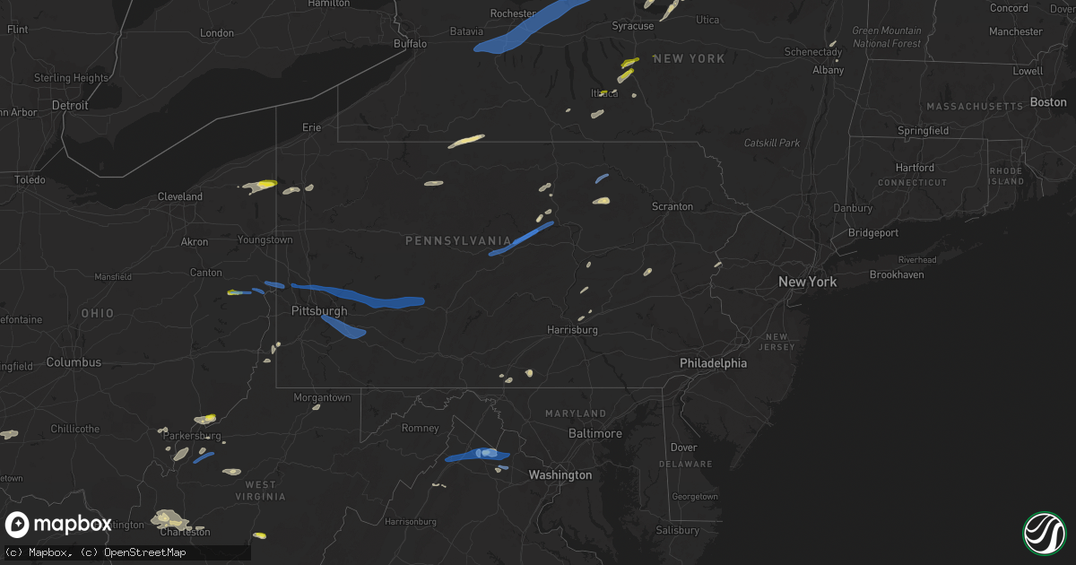
Hail Map in Pennsylvania on June 21, 2021
Get this storm
June 21 map
$229
one time, instant access
Download today. No call, no setup
Keep the $229
Bought the map and want the full workflow? Apply the entire $229 to a subscription within 7 days. None of it is wasted.
Every map, not just this one
This buys you this map. Subscription and you get every map we run, in the markets you choose from a few cities to whole states to nationwide. Plus real-time alerts the moment a storm fires.
Contact data
Name, contact info, occupancy, even credit band for addresses in the footprint. You go from where it hit to who to call.
Become the source they trust
Unlimited branding weather history reports on demand. You already have the documented answer ready for the property owner, and you are the one who showed up with it.
Property data and RoofTrace estimates
Pull up any address you have got, its value and the exact code rules for that jurisdiction, straight from One Click Code. Then RoofTrace estimates the squares, pitch, and roof value, priced the way you price.
Storm reports in Pennsylvania
Pennsylvania
| Date | Description |
|---|---|
| 06/21/20216:58 PM CDT | Downed trees and wires near route 447. Time estimated from radar. |
| 06/21/20216:58 PM CDT | Downed trees and wires near toll road. Time estimated from radar. |
| 06/21/20216:54 PM CDT | Downed trees and wires near mountain road. Time estimated from radar. |
| 06/21/20216:54 PM CDT | Downed power lines near derhammer road. Time estimated from radar. |
| 06/21/20216:52 PM CDT | Downed trees and wires near hallet road. Time estimated from radar. |
| 06/21/20216:50 PM CDT | Report of tree and wires down. Time estimated from radar. |
| 06/21/20216:47 PM CDT | Downed trees and wires near locust ridge road. Time estimated from radar. |
| 06/21/20216:45 PM CDT | Few reports of wires down in allentown. Time estimated from radar. |
| 06/21/20216:45 PM CDT | A few reports of wires down in the allentown and bethlehem areas. Time estimated from radar. |
| 06/21/20216:45 PM CDT | Downed trees and wires near grant street. Time estimated from radar. |
| 06/21/20216:45 PM CDT | Downed power lines near neffs laurys road. Time estimated from radar. |
| 06/21/20216:45 PM CDT | Few trees down in the bella vista area of philadelphia. Time estimated from radar. |
| 06/21/20216:43 PM CDT | Downed trees and wires near rimrock drive. Time estimated from radar. |
| 06/21/20216:40 PM CDT | Tree and wires down on broadway. Time estimated from radar. |
| 06/21/20216:40 PM CDT | Downed trees and wires near alley f and park lane. Time estimated from radar. |
| 06/21/20216:33 PM CDT | Trees and wires down in the pocono mountain lake estates area. Time estimated from radar. |
| 06/21/20216:31 PM CDT | Downed tree in wires near lentz trail and flagstaff road. Time estimated from radar. |
| 06/21/20216:30 PM CDT | Report of tree and wires down on sparrow lane. |
| 06/21/20216:30 PM CDT | Report of tree and wires down. Time estimated from radar. |
| 06/21/20216:29 PM CDT | Tree and wires down. Time estimated from radar. |
| 06/21/20216:29 PM CDT | Report of tree and wires down on main street in jim thorpe. Time estimated from radar. |
| 06/21/20216:25 PM CDT | Report of wires down. Time estimated from radar. |
| 06/21/20216:25 PM CDT | A few trees down. One on wires. |
| 06/21/20216:19 PM CDT | Downed trees and wires near blue rocks road. Time estimated from radar. |
| 06/21/20216:14 PM CDT | Tree downed into roadway. |
| 06/21/20216:13 PM CDT | Downed tree on goshen road. Time estimated from radar. |
| 06/21/20216:13 PM CDT | Downed tree on valley road. Time estimated from radar. |
| 06/21/20216:09 PM CDT | Tree and wires down. Time estimated from radar. |
| 06/21/20216:07 PM CDT | Downed tree on mill lane. Time estimated from radar. |
| 06/21/20216:05 PM CDT | Downed trees and wires near kegerise drive. Time estimated from radar. |
| 06/21/20216:02 PM CDT | Downed tree limbs on edge lane. Time estimated from radar. |
| 06/21/20216:02 PM CDT | Outflow winds downed trees and wires near hill road. Time estimated from radar. |
| 06/21/20216:00 PM CDT | Multiple reports of trees and wires down in east brandywine township. |
| 06/21/20215:58 PM CDT | Downed tree and wires and a downed power pole on a residence near forge lane. Time estimated from radar. |
| 06/21/20215:58 PM CDT | Downed tree on boot road. Time estimated from radar. |
| 06/21/20215:58 PM CDT | Downed trees on creek road. Time estimated from radar. |
| 06/21/20215:54 PM CDT | Downed tree on newark road. Time estimated from radar. |
| 06/21/20215:54 PM CDT | A few reports of trees and wires down in new garden township. |
| 06/21/20215:48 PM CDT | Tree and wires down. |
| 06/21/20215:46 PM CDT | Several reports of downed power lines in the area. Time estimated from radar. |
| 06/21/20215:45 PM CDT | Tree and wires down. |
| 06/21/20215:41 PM CDT | Downed tree on limestone road. Time estimated from radar. |
| 06/21/20215:38 PM CDT | Multiple trees down along lake jean. Time estimated by radar. |
| 06/21/20215:26 PM CDT | Downed trees and wires near hawk mountain road. Time estimated from radar. |
| 06/21/20215:15 PM CDT | Multiple reports of trees down in the willow street area. |
| 06/21/20215:08 PM CDT | Multiple trees down on sr-154 near worlds end state park. |
| 06/21/20215:00 PM CDT | Trees down at route 154 and shanersburg rd. |
| 06/21/20214:55 PM CDT | Trees down along worlds end rd. |
| 06/21/20214:47 PM CDT | Several reports of trees and wires down in windsor borough... Including manor rd... Smith road... And winterstown rd. |
| 06/21/20214:35 PM CDT | Tree down at 4832 barnhart hill rd |
| 06/21/20214:27 PM CDT | Trees down. |
| 06/21/20214:15 PM CDT | Multiple trees and wires down along woodward avenue between dunnstown and avis. |
| 06/21/20214:15 PM CDT | Multiple reports of trees and utility lines down across jefferson township. |
| 06/21/20214:14 PM CDT | Tree down near troy police department. |
| 06/21/20214:08 PM CDT | Tree down. |
| 06/21/20214:05 PM CDT | Tree down blocking arnot rd. |
| 06/21/20214:03 PM CDT | Multiple trees down across the county. |
| 06/21/20214:00 PM CDT | Multiple reports of trees and wires down including on the 700 blocks of somerset street and meade street in johnstown. |
| 06/21/20214:00 PM CDT | Widespread trees down from cashtown to fairfield. |
| 06/21/20214:00 PM CDT | Trees/wires down. |
| 06/21/20213:59 PM CDT | Multiple trees and wires down at the intersection of thomas hill rd. And runville rd. |
| 06/21/20213:57 PM CDT | Tree down |
| 06/21/20213:55 PM CDT | Trees down on morris run rd. |
| 06/21/20213:52 PM CDT | Tree down. |
| 06/21/20213:50 PM CDT | Multiple trees down. |
| 06/21/20213:50 PM CDT | Trees and power lines reported down in bruwh valley... Armaugh and home city. |
| 06/21/20213:48 PM CDT | Multiple trees down |
| 06/21/20213:48 PM CDT | Multiple large trees down on property off moritz rd near orrtanna. |
| 06/21/20213:47 PM CDT | Multiple reports of trees down along glendale lake rd east of patton. |
| 06/21/20213:45 PM CDT | Many trees down on roads from waynesboro to greencastle. |
| 06/21/20213:45 PM CDT | Line down across roadway. |
| 06/21/20213:40 PM CDT | Multiple reports of storm related damage across mt pleasant twp. |
| 06/21/20213:40 PM CDT | Multiple reports of storm related damage across south huntingdon twp. |
| 06/21/20213:39 PM CDT | Trees down across walker hill road |
| 06/21/20213:39 PM CDT | Utility lines down along bristoria road |
| 06/21/20213:38 PM CDT | Trees down on hunter school road |
| 06/21/20213:38 PM CDT | Multiple trees down at 606 old curtain rd. |
| 06/21/20213:35 PM CDT | Multiple trees down. |
| 06/21/20213:31 PM CDT | Trees down |
| 06/21/20213:30 PM CDT | Late report due to down phone lines since 6/21. Several trees down... Trees on wires... Power poles snapped. Singles blown off... Carport damaged. Described little to n |
| 06/21/20213:28 PM CDT | Report of trees down on wire. Time estimated based on radar. |
| 06/21/20213:25 PM CDT | Large tree down on wires blocking depot street |
| 06/21/20213:22 PM CDT | Report of large tree limbs down in greensburg. |
| 06/21/20213:21 PM CDT | Siding blown off home on state street. |
| 06/21/20213:13 PM CDT | Multiple trees down at halfmoon valley rd and winesap dr. Power outages in the area. |
| 06/21/20213:12 PM CDT | Tree down. |
| 06/21/20213:10 PM CDT | Tree down on roseville sigel road. |
| 06/21/20213:10 PM CDT | Multiple trees down across the county. |
| 06/21/20213:07 PM CDT | Trees down at intersection of wainwright and roth drive |
| 06/21/20213:07 PM CDT | Report of large tree blown down at the corner of maus and robbins station. Time estimated based on radar. |
| 06/21/20213:04 PM CDT | Some siding blown off house |
| 06/21/20213:01 PM CDT | Tree down |
| 06/21/20213:00 PM CDT | Tree down on water plant rd. |
| 06/21/20213:00 PM CDT | Trees down on residence in center township |
| 06/21/20212:59 PM CDT | Downed tree on pa route 66. |
| 06/21/20212:59 PM CDT | Widespread trees down across the county; about 20 different calls made to 911. |
| 06/21/20212:58 PM CDT | Trees down on hunter school road |
| 06/21/20212:55 PM CDT | Trees down on black lick road |
| 06/21/20212:54 PM CDT | Trees/wires down on thoms run road at pinch road. Thoms run road closed. |
| 06/21/20212:46 PM CDT | Large tree down on 46th street. |
| 06/21/20212:45 PM CDT | Large tree limbs down |
| 06/21/20212:40 PM CDT | Large tree blocking the boulevard of the allies |
| 06/21/20212:39 PM CDT | Trees down; video provided. |
| 06/21/20212:38 PM CDT | Multiple trees down. |
| 06/21/20212:38 PM CDT | Video of trees coming down from wind |
| 06/21/20212:35 PM CDT | Numerous trees down |
| 06/21/20212:30 PM CDT | Trees down near russell city. |
| 06/21/20212:28 PM CDT | Trees down along enterprise rd. |
| 06/21/20212:25 PM CDT | Numerous trees down |
| 06/21/20212:21 PM CDT | Trees down on powerlines along youngsville rd. |
| 06/21/20212:20 PM CDT | Trees down |
| 06/21/20212:20 PM CDT | Tree down on a house |
| 06/21/20212:10 PM CDT | Trees down across warrendale-bane road |
| 06/21/20212:05 PM CDT | Trees down on powerlines on highland road. |
| 06/21/20212:05 PM CDT | Tree and wires down |
| 06/21/20212:05 PM CDT | Tree and wires down |
| 06/21/20212:01 PM CDT | Several large branches snapped off at least four trees. |
| 06/21/20212:01 PM CDT | Tree down on 2 wires; photo provided. |
| 06/21/20211:58 PM CDT | Several small trees snapped ontop of at least three large branches. |
| 06/21/20211:58 PM CDT | Tree limbs down and shingle blown off roof. |
| 06/21/20211:57 PM CDT | Couple of trees down |
| 06/21/20211:55 PM CDT | Multiple trees down along tidioute enterprise rd. |
| 06/21/20211:54 PM CDT | Report of numerous snapped trees in seven fields. Time estimated based on radar. |
| 06/21/20211:53 PM CDT | Ef0 confirmed tornado |
| 06/21/20211:52 PM CDT | Two 50 foot trees knocked down |
| 06/21/20211:51 PM CDT | Over 20 large trees snapped or uprooted. |
| 06/21/20211:51 PM CDT | Large limbs down along state route 19 near the interchange of 79/76 |
| 06/21/20211:50 PM CDT | Several trees down |
| 06/21/20211:46 PM CDT | Trees and large limbs down |
| 06/21/20211:32 PM CDT | Couple of trees down |
| 06/21/20211:25 PM CDT | Power pole snapped and tree down over road. |
| 06/21/20211:24 PM CDT | Numerous trees down and power outages reported |
| 06/21/20211:13 PM CDT | Tree down on highway 6. |
| 06/21/20211:08 PM CDT | Tree down. |
| 06/21/20213:47 AM CDT | At 847 PM EDT, severe thunderstorms were located along a line extending from near Matamoras to High Point to near Sussex to Pellettown to near Branchville, moving northeast at 30 mph. HAZARD...60 mph wind gusts. SOURCE...Radar indicated. IMPACT...Expect damage to trees and power lines. Severe thunderstorms will be near... Port Jervis around 855 PM EDT. Huguenot and Unionville around 900 PM EDT. Cuddebackville around 910 PM EDT. Otisville around 915 PM EDT. Middletown and Howells around 920 PM EDT. Warwick and Goshen around 930 PM EDT. |
| 06/21/20213:13 AM CDT | At 812 PM EDT, severe thunderstorms were located along a line extending from Paupack to near Bangor, moving northeast at 45 mph. HAZARD...60 mph wind gusts. SOURCE...Law enforcement. IMPACT...Damage to roofs, siding, trees, and power lines is possible. Locations impacted include... Easton, Newton, Montague, Mount Pocono, Hopatcong, Forks, East Stroudsburg, Hackettstown, Washington, Blairstown, Bangor, Mount Arlington, Franklin, Stanhope, Pen Argyl, Hamburg, Netcong, Wind Gap, Belvidere and Harmony.This includes the following highways... Interstate 78 in Pennsylvania near mile marker 76. Interstate 78 in New Jersey between mile markers 0 and 4. Interstate 80 in Pennsylvania between mile markers 300 and 314. Interstate 80 in New Jersey between mile markers 0 and 30. |
| 06/21/20212:56 AM CDT | At 756 PM EDT, severe thunderstorms were located along a line extending from Corbett to near Bear Creek, moving northeast at 50 mph. HAZARD...60 mph wind gusts and quarter size hail. SOURCE...Radar indicated. IMPACT...Hail damage to vehicles is expected. Expect wind damage to roofs, siding, and trees. Locations impacted include... Rockland, Fallsburg, Bushkill, Monticello, Lackawaxen, Blooming Grove, Honesdale, Liberty, Bethel and Paupack. |
| 06/21/20212:38 AM CDT | At 738 PM EDT, severe thunderstorms were located along a line extending from near White Haven to Coffeetown, moving northeast at 35 mph. HAZARD...60 mph wind gusts and penny size hail. SOURCE...Law enforcement. Several reports of trees and wires down have been received from this line of storms. IMPACT...Damage to roofs, siding, trees, and power lines is possible. Locations impacted include... Allentown, Easton, Lehighton, Mount Pocono, Bethlehem, Forks, Emmaus, Northampton, East Stroudsburg, Tobyhanna, Wilson, Nazareth, Palmerton, Bangor, Jim Thorpe, Slatington, Pen Argyl, Wind Gap, Bath and Belvidere.This includes the following highways... Northeast Extension between mile markers 53 and 97. Interstate 78 in Pennsylvania between mile markers 51 and 60. Interstate 80 in Pennsylvania between mile markers 277 and 314. Interstate 80 in New Jersey between mile markers 0 and 10. Interstate 380 in Pennsylvania between mile markers 0 and 13. |
| 06/21/20212:35 AM CDT | At 735 PM EDT, severe thunderstorms were located along a line extending from near Forest City to near Equinunk, moving northeast at 50 mph. HAZARD...60 mph wind gusts. SOURCE...Radar indicated. IMPACT...Expect damage to roofs, siding, and trees. Locations impacted include... Walton, Delhi, Roxbury, Colchester, Kortright, Meredith, Hamden, Andes, Stamford and Hancock. |
| 06/21/20212:02 AM CDT | At 702 PM EDT, severe thunderstorms were located along a line extending from Nesquehoning to near Kutztown, moving northeast at 30 mph. HAZARD...60 mph wind gusts and penny size hail. SOURCE...Radar indicated. IMPACT...Damage to roofs, siding, trees, and power lines is possible. Locations impacted include... Lehighton, Northampton, Palmerton, Kutztown, Jim Thorpe, Hamburg, Slatington, Fleetwood, Nesquehoning, Weatherly, Walnutport, Topton, Leesport, Shoemakersville, Bernville, Lyons, Lenhartsville, New Mahoning, Neffs and Coffeetown.This includes the following highways... Northeast Extension between mile markers 57 and 97. Interstate 78 in Pennsylvania between mile markers 21 and 54. Interstate 80 in Pennsylvania between mile markers 277 and 283. |
| 06/21/20211:27 AM CDT | At 627 PM EDT, severe thunderstorms were located along a line extending from near Le Raysville to near Laceyville to near Lovelton to near Muncy Valley, moving east at 50 mph. HAZARD...60 mph wind gusts and quarter size hail. SOURCE...Radar indicated. IMPACT...Hail damage to vehicles is expected. Expect wind damage to roofs, siding, and trees. Locations impacted include... Falls, Muhlenberg, Vernon, Clarks Summit, Rush, Lehman, Dallas, Harveys Lake, Clifford and Tunkhannock. |
| 06/21/20211:15 AM CDT | At 615 PM EDT, a severe thunderstorm was located 7 miles southeast of Overton, moving east at 35 mph. HAZARD...60 mph wind gusts and quarter size hail. SOURCE...Radar indicated. IMPACT...Hail damage to vehicles is expected. Expect wind damage to roofs, siding, and trees. Locations impacted include... Dushore. |
| 06/21/20211:08 AM CDT | At 607 PM EDT, a severe thunderstorm was located near Shoemakersville, or 10 miles southeast of Schuylkill Haven, moving northeast at 30 mph. HAZARD...60 mph wind gusts and quarter size hail. SOURCE...Radar indicated. IMPACT...Minor damage to vehicles is possible. Wind damage to roofs, siding, trees, and power lines is possible. Locations impacted include... Kutztown, Hamburg, Sinking Spring, Womelsdorf, Wernersville, Robesonia, Leesport, Shoemakersville, Bernville, Strausstown, Lenhartsville, Fairview Hgts, Wanamakers, New Tripoli, Claussville, Spring Ridge, Centerport and Whitfield.This includes Interstate 78 in Pennsylvania between mile markers 18and 46. |
| 06/21/202112:31 AM CDT | At 529 PM EDT, severe thunderstorms were located along a line extending from near English Center to Duboistown, moving northeast at 50 mph. HAZARD...60 mph wind gusts and penny size hail. SOURCE...Law enforcement. IMPACT...Expect damage to roofs, siding, and trees. Locations impacted include... Williamsport, Montoursville, Duboistown, Kettle Creek Gorge, Cogan Station, Ralston, Ogdensburg, Trout Run, Lincoln Falls, Barbours, Shunk, Buttonwood, Loyalsockville, South Williamsport, Garden View, Forksville, Eagles Mere, Hillsgrove and Little League World Series Complex.This includes Interstate 180 near mile marker 22...and from milemarkers 25 to 29. |
| 06/21/202112:10 AM CDT | At 510 PM EDT, severe thunderstorms were located along a line extending from near Taneytown to Clover Hill, moving east at 35 mph. HAZARD...60 mph wind gusts. SOURCE...Radar indicated. IMPACT...Damaging winds will cause some trees and large branches to fall. This could injure those outdoors, as well as damage homes and vehicles. Roadways may become blocked by downed trees. Localized power outages are possible. Unsecured light objects may become projectiles. Locations impacted include... Frederick, Westminster, Harry Grove Stadium, Ballenger Creek, Taneytown, Hampstead, Walkersville, Manchester, New Market, Discovery-Spring Garden, Linganore-Bartonsville, Adamstown, New Windsor, Woodsboro, Buckeystown, Union Bridge, Libertytown, Monrovia, Finksburg and Carrollton. |
| 06/21/202112:08 AM CDT | At 507 PM EDT, severe thunderstorms were located along a line extending from near Lock Haven to Castanea to Mackeyville, moving northeast at 50 mph. HAZARD...60 mph wind gusts and nickel size hail. SOURCE...Radar indicated. IMPACT...Expect damage to roofs, siding, and trees. Locations impacted include... Lock Haven, Jersey Shore, Lamar, Mill Hall, Avis, Dunnstown, Flemington, Castanea, Blanchard, McElhattan, Monument, Waterville, Bald Eagle State Park, Mackeyville, Little Pine State Park, Howard, Beech Creek, Oval, Salladasburg and Lock Haven University.For those driving on Interstate 80, this includes areas between theMilesburg and Loganton exits, specifically from mile markers 160 to182. |
| 06/20/202111:57 PM CDT | At 457 PM EDT, a severe thunderstorm was located near Cameron, or 15 miles southeast of Moundsville, moving east at 35 mph. HAZARD...Wind gusts to 60 mph. SOURCE...Radar. IMPACT...Expect damage to trees and power lines, resulting in some power outages. Locations impacted include... Aleppo... Blacksville... Spraggs... New Freeport... Brave... |
| 06/20/202111:45 PM CDT | At 445 PM EDT, severe thunderstorms were located along a line extending from near Arnot to near Buttonwood to 7 miles west of Ralston to near Trout Run, moving northeast at 45 mph. HAZARD...60 mph wind gusts and quarter size hail. SOURCE...Radar indicated. IMPACT...Hail damage to vehicles is expected. Expect wind damage to roofs, siding, and trees. Locations impacted include... Blossburg, Arnot, Kettle Creek Gorge, Cogan Station, Ralston, Ogdensburg, Trout Run, Lincoln Falls, Barbours, Shunk, Buttonwood, Loyalsockville, Forksville and Hillsgrove. |
| 06/20/202111:43 PM CDT | At 443 PM EDT, a severe thunderstorm was located near Snow Shoe, moving northeast at 35 mph. HAZARD...60 mph wind gusts and quarter size hail. SOURCE...Radar indicated. IMPACT...Hail damage to vehicles is expected. Expect wind damage to roofs, siding, and trees. Locations impacted include... Snow Shoe, Monument, Unionville and Orviston. For those driving on Interstate 80, this includes areas between theSnow Shoe and Milesburg exits, specifically from mile markers 147 to156. |
| 06/20/202111:43 PM CDT | At 443 PM EDT, a severe thunderstorm was located near Ligonier, or 11 miles southeast of Latrobe, moving east at 45 mph. HAZARD...Wind gusts to 60 mph. SOURCE...Radar. IMPACT...Expect damage to trees and power lines, resulting in some power outages. Locations impacted include... Ligonier... New Florence... Laurel Mountain... Loyalhanna Gorge... Laurel Mountain State Park... Acme...This includes Pennsylvania Turnpike between mile markers 86 and 87,and between mile markers 94 and 99. |
| 06/20/202111:41 PM CDT | At 441 PM EDT, severe thunderstorms were located along a line extending from near West Newton to Brownsville, moving east at 45 mph. HAZARD...Wind gusts to 60 mph. SOURCE...Radar. IMPACT...Expect damage to trees and power lines, resulting in some power outages. Locations impacted include... Uniontown... Connellsville... Waynesburg... California... Scottdale... Masontown... Brownsville... Fredericktown-Millsboro... South Connellsville... Perryopolis... Fairdale... Jefferson Boro...This includes Interstate 79 in Pennsylvania between mile markers 13and 20. |
| 06/20/202111:39 PM CDT | At 439 PM EDT, severe thunderstorms were located along a line extending from 8 miles west of Vinco to 7 miles south of Lawson Heights, moving east at 60 mph. HAZARD...60 mph wind gusts. SOURCE...Radar indicated. IMPACT...Expect damage to roofs, siding, and trees. Locations impacted include... Johnstown, Westmont, Windber, Belmont, Portage, Geistown, Southmont, Vinco, Boswell, Dale, East Conemaugh, Salix-Beauty Line Park, Davidsville, Central City, Beaverdale-Lloydell, Paint, Jerome, South Fork, Scalp Level and Sidman. |
| 06/20/202111:31 PM CDT | At 431 PM EDT, a severe thunderstorm was located over Marion, moving east at 30 mph. HAZARD...60 mph wind gusts and quarter size hail. SOURCE...Radar indicated. IMPACT...Hail damage to vehicles is expected. Expect wind damage to roofs, siding, and trees. Locations impacted include... Chambersburg, Waynesboro, Gettysburg, Greencastle, Guilford, Carroll Valley, Fayetteville, Wayne Heights, Mont Alto, Lake Heritage, Rouzerville, Marion, Cashtown, Aspers, Orrtanna, State Line, Biglerville, Arendtsville, Bendersville and Fairfield.This includes Interstate 81 from mile markers 1 to 15. |
| 06/20/202111:28 PM CDT | At 428 PM EDT, a severe thunderstorm was located near Mount Pleasant, or 10 miles south of Greensburg, moving east at 50 mph. HAZARD...Wind gusts to 60 mph. SOURCE...Radar. IMPACT...Expect damage to trees and power lines, resulting in some power outages. Locations impacted include... Monessen... Mount Pleasant... Scottdale... Youngwood... West Newton... New Stanton... North Belle Vernon... Calumet-Norvelt... Lynnwood-Pricedale... Everson... Smithton... Madison...This includes the following highways... Interstate 70 in Pennsylvania between mile markers 42 and 57. Pennsylvania Turnpike between mile markers 71 and 95. |
| 06/20/202111:28 PM CDT | At 428 PM EDT, severe thunderstorms were located along a line extending from 6 miles southwest of Northern Cambria to near Belsano, moving east at 45 mph. HAZARD...60 mph wind gusts. SOURCE...Radar indicated. IMPACT...Expect damage to roofs, siding, and trees. Locations impacted include... Ebensburg, Nanty-Glo, Northern Cambria, Patton, Cresson, Gallitzin, Vinco, Loretto, Hastings, Lilly, Carrolltown, Sankertown, Belsano, Prince Gallitzin State Park, Mundys Corner, Colver, Vintondale, Ashville, Chest Springs and Cassandra. |
| 06/20/202111:27 PM CDT | At 427 PM EDT, a severe thunderstorm was located over Black Lick, or near Homer City, moving east at 40 mph. HAZARD...Wind gusts to 60 mph. SOURCE...Radar. IMPACT...Expect damage to trees and power lines, resulting in some power outages. Locations impacted include... Blairsville... Black Lick... New Florence... Seward... Bolivar... Armagh... |
| 06/20/202111:25 PM CDT | At 425 PM EDT, severe thunderstorms were located along a line extending from near Wilson-Conococheague to Boonsboro, moving east at 35 mph. HAZARD...60 mph wind gusts. SOURCE...Radar indicated. IMPACT...Damaging winds will cause some trees and large branches to fall. This could injure those outdoors, as well as damage homes and vehicles. Roadways may become blocked by downed trees. Localized power outages are possible. Unsecured light objects may become projectiles. Locations impacted include... Frederick, Thurmont, Emmitsburg, Taneytown, Walkersville, Smithsburg, Braddock Heights, Mount Aetna, Mount Lena, Clover Hill, Discovery-Spring Garden, Wolfsville, Myersville, Cavetown, New Windsor, Woodsboro, Union Bridge, Libertytown, Sabillasville and Fort Ritchie. |
| 06/20/202111:18 PM CDT | At 418 PM EDT, severe thunderstorms were located along a line extending from near Youngwood to 6 miles northwest of Waynesburg, moving east at 40 mph. HAZARD...Wind gusts to 60 mph. SOURCE...Radar. IMPACT...Expect damage to trees and power lines, resulting in some power outages. Locations impacted include... Monessen... California... Charleroi... Bentleyville... Brownsville... Fredericktown-Millsboro... Perryopolis... Fairdale... Jefferson Boro... North Belle Vernon... North Charleroi... Speers...This includes the following highways... Interstate 70 in Pennsylvania between mile markers 32 and 43. Interstate 79 in Pennsylvania between mile markers 16 and 26. |
| 06/20/202111:13 PM CDT | At 412 PM EDT, a severe thunderstorm was located near Greensburg, moving east at 55 mph. HAZARD...Wind gusts to 60 mph. SOURCE...Radar. IMPACT...Expect damage to trees and power lines, resulting in some power outages. Locations impacted include... Greensburg... Latrobe... McChesneytown-Loyalhanna... Youngwood... Derry... Lawson Heights... Ligonier... New Florence... Bolivar... Arona... Youngstown... Laurel Mountain... |
| 06/20/202111:05 PM CDT | At 405 PM EDT, severe thunderstorms were located along a line extending from near White Oak to Monongahela, moving southeast at 55 mph. HAZARD...Wind gusts to 60 mph. SOURCE...Radar. IMPACT...Expect damage to trees and power lines, resulting in some power outages. Locations impacted include... McKeesport... Jefferson Hills... White Oak... Clairton... Donora... Glassport... Mount Pleasant... Scottdale... Youngwood... West Newton... Liberty... New Stanton...This includes the following highways... Interstate 70 in Pennsylvania between mile markers 44 and 57. Pennsylvania Turnpike between mile markers 69 and 84. |
| 06/20/202110:57 PM CDT | At 357 PM EDT, a severe thunderstorm was located near Clarion, moving east at 25 mph. HAZARD...Wind gusts to 60 mph. SOURCE...Radar. IMPACT...Expect damage to trees and power lines, resulting in some power outages. Locations impacted include... Clarion... Brookville... Strattanville... Summerville... Limestone... Hawthorn... Corsica... Worthville... Knox-Dale... This includes Interstate 80 in Pennsylvania between mile markers 60and 84. |
| 06/20/202110:55 PM CDT | At 355 PM EDT, severe thunderstorms were located along a line extending from 7 miles south of Punxsutawney to near Blairsville, moving east at 50 mph. HAZARD...Wind gusts to 60 mph. SOURCE...Radar. IMPACT...Expect damage to trees and power lines, resulting in some power outages. Locations impacted include... Indiana... Homer City... Blairsville... Derry... Black Lick... Clymer... Avonmore... Saltsburg... West Lebanon... New Florence... New Alexandria... Chevy Chase Heights... |
| 06/20/202110:45 PM CDT | At 345 PM EDT, a severe thunderstorm was located over Penn Hills, moving east at 45 mph. HAZARD...Wind gusts to 60 mph. SOURCE...Radar. IMPACT...Expect damage to trees and power lines, resulting in some power outages. Locations impacted include... Pittsburgh... Penn Hills... Mount Lebanon... Ross Township... Monroeville... Greensburg... McKeesport... Jeannette... Apollo... Shaler Township... Plum... West Mifflin...This includes the following highways... Pennsylvania Turnpike between mile markers 45 and 69. Interstate 79 in Pennsylvania between mile markers 58 and 60. Interstate 376 in Pennsylvania between mile markers 62 and 84. |
| 06/20/202110:37 PM CDT | At 337 PM EDT, severe thunderstorms were located along a line extending from 9 miles southeast of New Bethlehem to near Murrysville, moving east at 55 mph. HAZARD...Wind gusts to 60 mph. SOURCE...Radar. IMPACT...Expect damage to trees and power lines, resulting in some power outages. Locations impacted include... Monroeville... Indiana... Punxsutawney... Vandergrift... Homer City... Apollo... Plum... Murrysville... Clymer... North Apollo... Avonmore... Orchard Hills... |
| 06/20/202110:29 PM CDT | At 329 PM EDT, a severe thunderstorm was located near Shinglehouse, or 10 miles southwest of Wellsville, moving east at 35 mph. HAZARD...60 mph wind gusts and quarter size hail. SOURCE...Radar indicated. IMPACT...Hail damage to vehicles is expected. Expect wind damage to roofs, siding, and trees. Locations impacted include... Canisteo, Woodhull, Jasper, Troupsburg, Cameron, Greenwood, West Cameron, Willeyville, Young Hickory and West Greenwood. |
| 06/20/202110:26 PM CDT | At 325 PM EDT, severe thunderstorms were located along a line extending from Wetmore to James City to 10 miles southwest of Kane, moving east at 45 mph. HAZARD...60 mph wind gusts and quarter size hail. SOURCE...Radar indicated. IMPACT...Hail damage to vehicles is expected. Expect wind damage to roofs, siding, and trees. Locations impacted include... Kane, Port Allegany, Sheffield, Smethport, Wetmore, Betula, Wilcox, James City, Crosby, Ludlow, East Branch Dam, Kinzua Bridge State Park, Westline, Mount Jewett and Bradford Airport. |
| 06/20/202110:25 PM CDT | At 325 PM EDT, severe thunderstorms were located along a line extending from McCandless Township to near Imperial, moving east at 40 mph. HAZARD...Wind gusts to 60 mph. SOURCE...Radar. IMPACT...Expect damage to trees and power lines, resulting in some power outages. Locations impacted include... Pittsburgh... Penn Hills... Ross Township... McCandless Township... Monroeville... Moon Township... Franklin Park... Shaler Township... Plum... West Mifflin... North Side Pittsburgh... Baldwin...This includes the following highways... Pennsylvania Turnpike between mile markers 39 and 57. Interstate 79 in Pennsylvania between mile markers 59 and 74. Interstate 376 in Pennsylvania between mile markers 48 and 84. |
| 06/20/202110:21 PM CDT | At 321 PM EDT, severe thunderstorms were located along a line extending from near Kittanning to Penn Hills, moving east at 60 mph. HAZARD...Wind gusts to 60 mph. SOURCE...Radar. IMPACT...Expect damage to trees and power lines, resulting in some power outages. Locations impacted include... Pittsburgh... Penn Hills... Monroeville... Vandergrift... Kittanning... Apollo... Plum... West Mifflin... Murrysville... Wilkinsburg... New Kensington... Lower Burrell...This includes the following highways... Pennsylvania Turnpike between mile markers 45 and 64. Interstate 376 in Pennsylvania between mile markers 74 and 84. |
| 06/20/202110:14 PM CDT | At 314 PM EDT, a severe thunderstorm was located over Kinzua Bridge State Park, moving east at 40 mph. HAZARD...60 mph wind gusts and quarter size hail. SOURCE...Radar indicated. IMPACT...Hail damage to vehicles is expected. Expect wind damage to roofs, siding, and trees. Locations impacted include... Port Allegany, Smethport, Coryville, Crosby, Kinzua Bridge State Park, Cyclone, Mount Jewett and Bradford Airport. |
| 06/20/202110:07 PM CDT | At 307 PM EDT, a severe thunderstorm was located near Shinglehouse, or 11 miles southeast of Olean, moving northeast at 40 mph. HAZARD...60 mph wind gusts and penny size hail. SOURCE...Radar indicated. IMPACT...Expect damage to roofs, siding, and trees. Locations impacted include... Wellsville, Alfred, Whitesville, Scio, Bolivar, Andover, Portville, Alma, Richburg and Stannards. |
| 06/20/202110:00 PM CDT | At 300 PM EDT, severe thunderstorms were located along a line extending from near New Cumberland to Wintersville to 6 miles east of Cadiz, moving east at 40 mph. HAZARD...Wind gusts to 60 mph. SOURCE...Radar. IMPACT...Expect damage to trees and power lines, resulting in some power outages. Locations impacted include... Weirton... Steubenville... Cadiz... Wellsburg... West Liberty... Avella... Robinson Township... Cecil-Bishop... Kennedy Township... Toronto... Wintersville... Mingo Junction...This includes the following highways... Interstate 79 in Pennsylvania between mile markers 60 and 62. Interstate 376 in Pennsylvania between mile markers 52 and 63. |
| 06/20/20219:55 PM CDT | At 255 PM EDT, severe thunderstorms were located along a line extending from near Oak Hills to 6 miles east of Weirton, moving east at 60 mph. HAZARD...Wind gusts to 60 mph. SOURCE...Radar. IMPACT...Expect damage to trees and power lines, resulting in some power outages. Locations impacted include... Pittsburgh... Penn Hills... Ross Township... McCandless Township... Cranberry... Moon Township... Butler... Franklin Park... Aliquippa... Vandergrift... Shaler Township... Plum...This includes the following highways... Pennsylvania Turnpike between mile markers 26 and 52. Interstate 79 in Pennsylvania between mile markers 62 and 82. Interstate 376 in Pennsylvania between mile markers 48 and 52, and between mile markers 69 and 74. |
| 06/20/20219:45 PM CDT | At 245 PM EDT, a severe thunderstorm was located over Enterprise, or 12 miles northeast of Oil City, moving east at 55 mph. HAZARD...Wind gusts to 60 mph. SOURCE...Radar. IMPACT...Expect damage to trees and power lines, resulting in some power outages. Locations impacted include... Marienville... Tionesta... Pleasantville... Kellettville... West Hickory... Starr... East Hickory... Oil Creek State Park... |
| 06/20/20219:43 PM CDT | At 243 PM EDT, a severe thunderstorm was located near Enterprise, moving east at 45 mph. HAZARD...60 mph wind gusts and quarter size hail. SOURCE...Radar indicated. IMPACT...Hail damage to vehicles is expected. Expect wind damage to roofs, siding, and trees. Locations impacted include... Warren, Sheffield, Wetmore, Ludlow, Warren South, Kinzua Dam, Grand Valley, Chapman State Park, Tidioute, Starbrick and Clarendon. |
| 06/20/20219:15 PM CDT | At 213 PM EDT, a severe thunderstorm was located 8 miles south of Guys Mills, or 11 miles southeast of Meadville, moving east at 55 mph. HAZARD...Wind gusts to 60 mph. SOURCE...Radar. IMPACT...Expect damage to trees and power lines, resulting in some power outages. Locations impacted include... Oil City... Franklin... Sugarcreek... Hasson Heights... Seneca... Rouseville... Cooperstown... Woodland Heights... Pleasantville... Utica... Oil Creek State Park... Maurice K Goddard State Park...This includes Interstate 79 in Pennsylvania between mile markers 135and 137. |
| 06/20/20219:06 PM CDT | At 206 PM EDT, severe thunderstorms were located along a line extending from Meadville to Adamsville, moving east at 35 mph. HAZARD...60 mph wind gusts and half dollar size hail. SOURCE...Radar indicated. IMPACT...People and animals outdoors will be injured. Expect hail damage to roofs, siding, windows, and vehicles. Expect damage to trees and power lines. Locations impacted include... Meadville, Titusville, Harmonsburg, Adamsville, Guys Mills, Atlantic, Cochranton, Saegertown, Conneaut Lake, Hydetown, Blooming Valley, Townville, Conneaut Lakeshore, Geneva and Hartstown. |
| 06/20/20218:15 PM CDT | At 115 PM EDT, a severe thunderstorm was located near Andover, or 19 miles south of Ashtabula, moving east at 25 mph. HAZARD...60 mph wind gusts and quarter size hail. SOURCE...Radar indicated. IMPACT...Minor damage to vehicles is possible. Expect damage to trees and power lines. Locations impacted include... Meadville, Andover, Linesville, Harmonsburg, Adamsville, Pymatuning North, Pymatuning Central, Atlantic, Roaming Shores, Saegertown, Cherry Valley, Conneautville, Conneaut Lake, Jamestown, Venango, Woodcock, Conneaut Lakeshore, Geneva and Hartstown. |
| 06/20/20217:22 PM CDT | Downed tree in wires near the intersection of miller road and richmond road. Time estimated from radar. |
| 06/20/20217:15 PM CDT | Downed power lines near deer run road. Time estimated from radar. |
| 06/20/20217:15 PM CDT | Tree and wires down blocking road. |
| 06/20/20217:12 PM CDT | Several reports of downed trees and wires in the richmond area. Time estimated from radar. |
| 06/20/20217:10 PM CDT | Multiple reports of trees and wires down around bangor and washington township. Time estimated from radar. |
| 06/20/20217:10 PM CDT | Report of wires down along river road. Time estimated from radar. |
| 06/20/20217:08 PM CDT | Downed trees and wires near franklin hill road. Time estimated from radar. |
| 06/20/20217:05 PM CDT | Downed trees and wires near wiltshire road. Time estimated from radar. |
| 06/20/20217:05 PM CDT | Tree down on wires across roadway. |
All States Impacted by Hail Map on June 21, 2021
Cities Impacted by Hail Map on June 21, 2021
- Mount Pleasant, AR
- Marlin, TX
- Madisonville, TX
- Ledbetter, TX
- Round Top, TX
- Compton, AR
- Green Forest, AR
- Berryville, AR
- Alpena, AR
- Chestertown, MD
- Worton, MD
- Boone, NC
- Blowing Rock, NC
- Babson Park, FL
- Lake Wales, FL
- Jackman, ME
- Fort Stockton, TX
- Marathon, TX
- Berryville, VA
- Bluemont, VA
- Salado, TX
- Paint Rock, TX
- Rowena, TX
- Falls Of Rough, KY
- Fredericksburg, TX
- Colebrook, NH
- Tamaqua, PA
- Coaldale, PA
- Nesquehoning, PA
- Chambersburg, PA
- Greencastle, PA
- Paris, TN
- Cottage Grove, TN
- Puryear, TN
- Knob Lick, KY
- Glasgow, KY
- Grantsville, WV
- Summersville, WV
- Craigsville, WV
- Kerrville, TX
- Allardt, TN
- Jamestown, TN
- Winfield, WV
- Scott Depot, WV
- Wilcox, PA
- Ferrisburgh, VT
- Harrisburg, PA
- Bristol, VT
- Waitsfield, VT
- Starksboro, VT
- Dorset, OH
- Andover, OH
- Jefferson, OH
- Iola, TX
- Bedias, TX
- Everton, AR
- Hudson Falls, NY
- Florence, TX
- Cortland, NY
- Freeville, NY
- Bernhards Bay, NY
- Cleveland, NY
- Rogersville, TN
- Thorn Hill, TN
- Sneedville, TN
- Mooresburg, TN
- Sparta, TN
- Jersey Shore, PA
- Poca, WV
- Hurricane, WV
- Red House, WV
- Saint Albans, WV
- Nitro, WV
- Charleston, WV
- Ozona, TX
- Muncy Valley, PA
- Forksville, PA
- Dushore, PA
- Stonewall, TX
- Edinburg, VA
- Marble Falls, TX
- Spicewood, TX
- Vincent, KY
- Booneville, KY
- Tuttle, OK
- Blanchard, OK
- Orwell, OH
- Bardstown, KY
- Coxs Creek, KY
- Boston, KY
- Shepherdsville, KY
- Leitchfield, KY
- Hornersville, MO
- Llano, TX
- Dryden, TX
- Ballinger, TX
- Piseco, NY
- Lake Pleasant, NY
- Wellington, KY
- Frenchburg, KY
- Dallas, WV
- Wheeling, WV
- Moundsville, WV
- Belton, TX
- Fulton, KY
- McKee, KY
- Williamsfield, OH
- Rome, OH
- Liberty Hill, TX
- Rockwood, TN
- Harriman, TN
- Waelder, TX
- Flatonia, TX
- Gonzales, TX
- Shiner, TX
- Mcminnville, TN
- Quebeck, TN
- Crossville, TN
- Walling, TN
- Smithville, TN
- Rock Island, TN
- Doyle, TN
- Bolivar, NY
- Shinglehouse, PA
- Ceres, NY
- Alma, NY
- Little Genesee, NY
- Eldred, PA
- Wellsville, NY
- Herndon, PA
- Gratz, PA
- Klingerstown, PA
- Lykens, PA
- Reno, OH
- Newport, OH
- Marietta, OH
- Williamstown, WV
- Whipple, OH
- Rising Star, TX
- Johnson City, TX
- Orrtanna, PA
- Middlebury, VT
- North Ferrisburgh, VT
- New Haven, VT
- Vergennes, VT
- Ponca, AR
- Iraan, TX
- Shelbyville, TN
- Tipton, OK
- Martinsville, OH
- Lynchburg, OH
- Hillsboro, OH
- Midland, OH
- New Vienna, OH
- Fenwick, WV
- Campbellsville, KY
- Homer, NY
- Cub Run, KY
- Mammoth Cave, KY
- Durhamville, NY
- Portville, NY
- Hopkinsville, KY
- Reagan, TX
- Crab Orchard, TN
- Cairo, WV
- Rochelle, TX
- Belleville, WV
- Mineral Wells, WV
- Danville, AR
- Waynesburg, KY
- Murfreesboro, TN
- Kissimmee, FL
- Bonnieville, KY
- Magnolia, KY
- Brownsville, KY
- Bowling Green, KY
- Sweetwater, TN
- Niota, TN
- Headrick, OK
- Kenansville, FL
- Comstock, TX
- Ozark, AR
- Ratcliff, AR
- Cold Brook, NY
- Lebanon, KY
- Jarrell, TX
- Schroon Lake, NY
- North Hudson, NY
- Granville, NY
- Boyce, VA
- College Station, TX
- Smethport, PA
- Groton, NY
- Fairfield, PA
- Kenton, TN
- Spencer, NY
- Van Etten, NY
- Cayuta, NY
- Erin, NY
- Jamestown, KY
- Burkesville, KY
- Rockport, WV
- Ravenswood, WV
- Rocksprings, TX
- Fort Pierce, FL
- North Zulch, TX
- Anderson, TX
- Troy, NY
- Burnet, TX
- Danville, PA
- Sunbury, PA
- Bloomfield, KY
- Horseshoe Bay, TX
- Ashland, ME
- Mountain View, AR
- Beaver Dam, KY
- Dawson Springs, KY
- Elkview, WV
- Summersville, KY
- Yellville, AR
- Alicia, AR
- Walnut Ridge, AR
- Melrose, NY
- Mechanicville, NY
- Schaghticoke, NY
- Queensbury, NY
- Fort Ann, NY
- Sebring, FL
- Hartstown, PA
- Conneaut Lake, PA
- Atlantic, PA
- Taberg, NY
- Crab Orchard, KY
- Stanford, KY
- Holland, TX
- Temple, TX
- Rogers, TX
- Lovelady, TX
- Schulenburg, TX
- Leander, TX
- Bertram, TX
- Big Bend, WV
- Normantown, WV
- Glenville, WV
- Arnoldsburg, WV
- Big Springs, WV
- Dunbar, WV
- South Charleston, WV
- Fraziers Bottom, WV
- Eleanor, WV
- Ezel, KY
- Saint Cloud, FL
- Thurmont, MD
- Rocky Ridge, MD
- Rome, NY
- Blossvale, NY
- Canastota, NY
- Oneida, NY
- Triadelphia, WV
- Valley Grove, WV
- Pioneer, TN
- Oneida, TN
- Navasota, TX
- Willow City, TX
- Clinton, KY
- South Fulton, TN
- Grapeland, TX
- Crockett, TX
- Nixon, TX
- Caribou, ME
- Fort Fairfield, ME
- West Liberty, KY
- Elkfork, KY
- Carmine, TX
- Burton, TX
- Daytona Beach, FL
- Ormond Beach, FL
- Sharon, TN
- Martin, TN
- Munfordville, KY
- Rocky Top, TN
- Clinton, TN
- Barksdale, TX
- Mapleton, ME
- Clarkson, KY
- Moriah, NY
- Port Henry, NY
- Crown Point, NY
- Lancing, TN
- Wartburg, TN
- Sheffield, TX
- Rosebud, TX
- Burlington, TX
- Stanton, KY
- Round Mountain, TX
- Ferguson, NC
- La Follette, TN
- Carlsbad, TX
- West Alexander, PA
- Claysville, PA
- Camden, NY
- Constantia, NY
- Ava, NY
- Lee Center, NY
- Waynesboro, PA
- Olustee, OK
- Mangum, OK
- Duke, OK
- Altus, OK
- Ingram, TX
- Helenwood, TN
- Robbins, TN
- Manila, AR
- Lott, TX
- Elmer, OK
- Frederick, OK
- May, TX
- Tazewell, TN
- Oliver Springs, TN
- Sharpsburg, MD
- Keedysville, MD
- Coolville, OH
- Guysville, OH
- Stewart, OH
- Athens, OH
- Cutler, OH
- McKenzie, TN
- Henry, TN
- Gleason, TN
- Purlear, NC
- Deep Gap, NC
- Fort Valley, VA
- Mayfield, KY
- Del Rio, TX
- Bell Buckle, TN
- La Grange, TX
- Little York, NY
- Preble, NY
- Vanderpool, TX
- Leakey, TX
- Eubank, KY
- Science Hill, KY
- Ithaca, NY
- Mechanicstown, OH
- Carrollton, OH
- Windsor, OH
- Wingo, KY
- Water Valley, KY
- Prairie Grove, AR
- Lithia, FL
- Mulberry, FL
- Plant City, FL
- Trout Run, PA
- Liberty, PA
- Morgantown, WV
- Fairmont, WV
- Morrison, TN
- Mount Enterprise, TX
- Princeton, KY
- Trenton, FL
- Bangor, PA
- Mount Bethel, PA
- Columbia, NJ
- Albany, KY
- Monticello, KY
- Alpha, KY
- Kings Mountain, KY
- Dyer, TN
- Reedsville, OH
- Walker, WV
- Elizabeth, WV
- Port Saint Lucie, FL
- Buchanan Dam, TX
- Killeen, TX
- Georgetown, TX
- Blossburg, PA
- Morris, PA
- Eidson, TN
- Round Hill, VA
- Harpers Ferry, WV
- Athens, AL
- Leesville, TX
- Meadville, PA
- Cochranton, PA
- Delbarton, WV
- Logan, WV
- North Wilkesboro, NC
- McGrady, NC
- Caneyville, KY
- Grantville, PA
- Annville, PA
- Brodhead, KY
- Kattskill Bay, NY
- Lake George, NY
- Middleburg, VA
- Marshall, VA
- The Plains, VA
- Roundhill, KY
- Bee Spring, KY
- Waverly, WV
- Leachville, AR
- Camp Wood, TX
- Hardinsburg, KY
- Hunt, TX
- Richford, NY
- Marathon, NY
- Adamsville, PA
- Jamestown, PA
- Cromwell, KY
- Horse Branch, KY
- Morgantown, KY
- Huntington, AR
- Mansfield, AR
- Washburn, ME
- Beaver Dams, NY
- Linesville, PA
- Salineville, OH
- White Post, VA
- Front Royal, VA
- Strasburg, VA
- Upperville, VA
- Stephens City, VA
- Winchester, VA
- Paris, VA
- Leesburg, VA
- Middletown, VA
- Purcellville, VA
- Guildhall, VT
- Errol, NH
- Lakeland, FL
- Waco, KY
- Richmond, KY
- Irvine, KY
- Winchester, KY
- Clay City, KY
- Caryville, TN
- Huntsville, TN
- New Market, TN
- Oak Ridge, TN
- Knoxville, TN
- Mascot, TN
- Luttrell, TN
- Powell, TN
- Blaine, TN
- Strawberry Plains, TN
- Heiskell, TN
- Corryton, TN
- Tully, NY
- De Ruyter, NY
- Whitehall, NY
- Palestine, WV
- Calvin, WV
- Carthage, NY
- Natural Bridge, NY
- Harrisville, NY
- Castorland, NY
- Lowville, NY
- Croghan, NY
- Caledonia, NY
- Lakeville, NY
- Minetto, NY
- Farmington, NY
- North Rose, NY
- Macedon, NY
- Mendon, NY
- Piffard, NY
- Sterling, NY
- York, NY
- Altmar, NY
- Retsof, NY
- Wolcott, NY
- Honeoye Falls, NY
- Lima, NY
- Pulaski, NY
- Le Roy, NY
- Marion, NY
- Hannibal, NY
- Leicester, NY
- Walworth, NY
- Rush, NY
- Martville, NY
- Ionia, NY
- Lyons, NY
- Fairport, NY
- Livonia, NY
- Williamson, NY
- Pavilion, NY
- Fulton, NY
- Avon, NY
- Victor, NY
- Wyoming, NY
- Mexico, NY
- Pittsford, NY
- Palmyra, NY
- Bloomfield, NY
- Red Creek, NY
- Shortsville, NY
- Sodus Point, NY
- Richland, NY
- Sodus, NY
- Geneseo, NY
- West Bloomfield, NY
- Linwood, NY
- Newark, NY
- Oswego, NY
- Island Pond, VT
- Saint Johnsbury, VT
- Danville, VT
- Concord, VT
- Littleton, NH
- East Liverpool, OH
- Industry, PA
- Lisbon, OH
- Midland, PA
- Wellsville, OH
- Hammondsville, OH
- Apollo, PA
- Beaver, PA
- Penn Run, PA
- Mars, PA
- Bairdford, PA
- Homer City, PA
- Tarentum, PA
- Conway, PA
- Blairsville, PA
- Northern Cambria, PA
- Dilltown, PA
- Natrona Heights, PA
- Leechburg, PA
- Josephine, PA
- Cheswick, PA
- Hyde Park, PA
- Saltsburg, PA
- Avonmore, PA
- Twin Rocks, PA
- Warrendale, PA
- Wexford, PA
- Strongstown, PA
- Nicktown, PA
- Bakerstown, PA
- Nanty Glo, PA
- Cranberry Township, PA
- Belsano, PA
- Colver, PA
- East Vandergrift, PA
- Armagh, PA
- Indiana, PA
- Russellton, PA
- Coral, PA
- Monaca, PA
- New Kensington, PA
- Brackenridge, PA
- Freedom, PA
- Creighton, PA
- Carrolltown, PA
- Vintondale, PA
- Clune, PA
- Gibsonia, PA
- North Apollo, PA
- Clarksburg, PA
- Valencia, PA
- Baden, PA
- Vandergrift, PA
- Brush Valley, PA
- Ebensburg, PA
- Shelocta, PA
- Spring Church, PA
- Irwin, PA
- Adamsburg, PA
- Jeannette, PA
- Westmoreland City, PA
- Larimer, PA
- Rillton, PA
- Herminie, PA
- Pleasant Unity, PA
- West Newton, PA
- New Stanton, PA
- Arona, PA
- Greenock, PA
- Madison, PA
- Ruffs Dale, PA
- Homestead, PA
- North Versailles, PA
- Dravosburg, PA
- Youngwood, PA
- Duquesne, PA
- Mount Pleasant, PA
- Darragh, PA
- West Mifflin, PA
- Latrobe, PA
- Glassport, PA
- Pittsburgh, PA
- Hunker, PA
- Greensburg, PA
- Mckeesport, PA
- Yukon, PA
- Bellefonte, PA
- Avis, PA
- Lock Haven, PA
- Howard, PA
- Julian, PA
- Blanchard, PA
- Mill Hall, PA
- Beech Creek, PA
- Williamsport, PA
- Linden, PA
- Towanda, PA
- Monroeton, PA
- New Albany, PA


