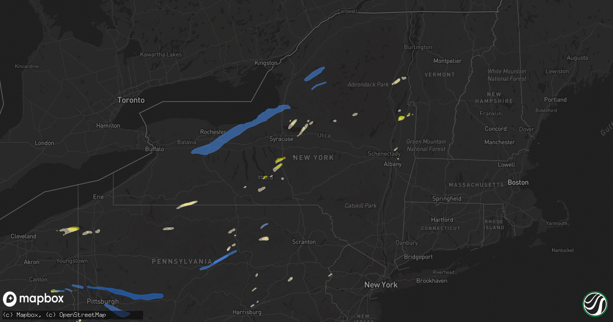
Hail Map in New York on June 21, 2021
Get this storm
June 21 map
$229
one time, instant access
Download today. No call, no setup
Keep the $229
Bought the map and want the full workflow? Apply the entire $229 to a subscription within 7 days. None of it is wasted.
Every map, not just this one
This buys you this map. Subscription and you get every map we run, in the markets you choose from a few cities to whole states to nationwide. Plus real-time alerts the moment a storm fires.
Contact data
Name, contact info, occupancy, even credit band for addresses in the footprint. You go from where it hit to who to call.
Become the source they trust
Unlimited branding weather history reports on demand. You already have the documented answer ready for the property owner, and you are the one who showed up with it.
Property data and RoofTrace estimates
Pull up any address you have got, its value and the exact code rules for that jurisdiction, straight from One Click Code. Then RoofTrace estimates the squares, pitch, and roof value, priced the way you price.
Storm reports in New York
New York
| Date | Description |
|---|---|
| 06/21/20216:55 PM CDT | Wires down on county route 1 in putnam. |
| 06/21/20216:50 PM CDT | Tree across road. |
| 06/21/20216:42 PM CDT | Trees across the road. |
| 06/21/20216:40 PM CDT | Tree blocking road. |
| 06/21/20216:28 PM CDT | Trees down near route 8 in lake pleasant town center. |
| 06/21/20216:12 PM CDT | Trees and wires down. |
| 06/21/20216:07 PM CDT | Trees down |
| 06/21/20216:04 PM CDT | Multiple trees down |
| 06/21/20215:35 PM CDT | All lanes on route 28 in old forge are blocked between crosby blvd and adams st due to wires down |
| 06/21/20215:35 PM CDT | Trees and wires down. Time estimated from radar. |
| 06/21/20215:31 PM CDT | Report of trees down |
| 06/21/20215:27 PM CDT | Tree down across road. |
| 06/21/20215:24 PM CDT | Trees and wires down across stony lake road. |
| 06/21/20215:17 PM CDT | Tree down on wire. |
| 06/21/20215:16 PM CDT | Trees down near pine grove rd and eatonville rd. And at gregg rd and brantingham rd. |
| 06/21/20215:14 PM CDT | Multiple trees down on pine grove rd near schoolhouse rd. Power poles blown down on barnes rd. |
| 06/21/20215:14 PM CDT | Trees down on blue st. |
| 06/21/20215:11 PM CDT | Trees down on seymore ave... And on shibley rd. |
| 06/21/20215:10 PM CDT | Lewis county dispatch reports widespread reports of storm damage... Primarily downed trees and powerlines... Across the county. This includes the towns of lowville... L |
| 06/21/20215:09 PM CDT | Trees down on marmon rd near penney settlement rd. |
| 06/21/20215:09 PM CDT | Trees down on e main st. |
| 06/21/20215:07 PM CDT | Tree and wires down on state route 22a in granville. |
| 06/21/20215:05 PM CDT | Trees and wires down. Also in marathon and virgil. Time estimated from radar. |
| 06/21/20215:05 PM CDT | Approximately 5 trees down... One fell on garage causing roof damage. Chicken coops heavily damaged or destroyed. Time is estimated by radar. |
| 06/21/20215:03 PM CDT | Trees and wires down on lincoln st and trees down on domser rd. |
| 06/21/20214:50 PM CDT | Tree and wires down on cross and butler road intersection. |
| 06/21/20214:49 PM CDT | A tornado touched down in yellow barn state forest... East of yellow barn road. It then tracked eastward and struck a farm on irish settlement road... Snapping and upro |
| 06/21/20214:48 PM CDT | A couple of trees down. |
| 06/21/20214:48 PM CDT | Several trees down along midline road. Some wires. Radar estimate. |
| 06/21/20214:47 PM CDT | Trees down on wire blocking road. |
| 06/21/20214:45 PM CDT | Large tree down on wires. |
| 06/21/20214:43 PM CDT | Several trees snapped. Also trees on wires and several large branches down in the area. Time estimated from radar. |
| 06/21/20214:40 PM CDT | Trees down on rt 26. |
| 06/21/20214:40 PM CDT | Tree down on road. |
| 06/21/20214:40 PM CDT | Trees and wires down in middle granville. |
| 06/21/20214:38 PM CDT | Trees and wires down on fisher settlement road. |
| 06/21/20214:37 PM CDT | Tree down on wires. |
| 06/21/20214:35 PM CDT | Trees and wires down heather ln... Rowena dr... Sherwood dr. |
| 06/21/20214:30 PM CDT | Tree and wires down south road in hampton. |
| 06/21/20214:30 PM CDT | Trees and wires down. |
| 06/21/20214:27 PM CDT | Tree down on wires. |
| 06/21/20214:25 PM CDT | Trees and wires down in hampton near route 22a. |
| 06/21/20214:25 PM CDT | Trees and wires down in kingsbury. |
| 06/21/20214:25 PM CDT | Trees and wires down. |
| 06/21/20214:25 PM CDT | Tree on power lines on bardin rd in kingsbury. |
| 06/21/20214:19 PM CDT | Large tree down on west seneca street. |
| 06/21/20214:15 PM CDT | Trees and wires down. |
| 06/21/20214:14 PM CDT | Measured asos wind gust. |
| 06/21/20214:10 PM CDT | Tree and wires down on lands end way in dresden. |
| 06/21/20214:05 PM CDT | Tree down across roadway. Corrected time |
| 06/21/20214:03 PM CDT | Tree uprooted. |
| 06/21/20213:57 PM CDT | Large tree down across road. |
| 06/21/20213:56 PM CDT | Tree and wires down near route 9n. |
| 06/21/20213:55 PM CDT | Multiple large trees down. Time radar estimated. |
| 06/21/20213:54 PM CDT | Tree down across road. |
| 06/21/20213:53 PM CDT | Trees and wires down in bolton landing. |
| 06/21/20213:45 PM CDT | Tree across roadway on county route 1. |
| 06/21/20213:45 PM CDT | Tree and wires down. |
| 06/21/20213:42 PM CDT | Multiple trees and wires down in vicinity of lee street and south street. Road is blocked. |
| 06/21/20213:40 PM CDT | Trees and wires down near route 8 and 9n. |
| 06/21/20213:39 PM CDT | Large trees and wires down. Time estimated from radar. |
| 06/21/20213:39 PM CDT | Multiple reports of tress down in the city of geneva. |
| 06/21/20213:26 PM CDT | Trees down including trees on power lines in the town of lyons. |
| 06/21/20213:20 PM CDT | Trees and power lines down. Time estimated from radar. |
| 06/21/20213:15 PM CDT | A local report indicates 1.00 inch wind near DERUYTER |
| 06/21/20213:15 PM CDT | Tree down on wires. Power pole snapped. |
| 06/21/20213:12 PM CDT | Trees down into a creek. |
| 06/21/20213:10 PM CDT | Tree down on trailer on quaker road. |
| 06/21/20213:07 PM CDT | Tree down on south shore rd |
| 06/21/20213:02 PM CDT | Trees down on fishers road near i-90. |
| 06/21/20213:01 PM CDT | Multiple reports of trees down including trees on power lines. |
| 06/21/20213:00 PM CDT | Multiple reports of trees down on several roads. One on a house. |
| 06/21/20213:00 PM CDT | A house on duncott road near highway 31 had a tree cut into the front of the house. |
| 06/21/20212:58 PM CDT | Tree down on wires near route 31 and 36. |
| 06/21/20212:58 PM CDT | Half dozen trees blown down or uprooted. A few trees were snapped off 20-25 feet above ground. |
| 06/21/20212:58 PM CDT | Significant tree damage on i-490 at route 96 in bushnells basin. |
| 06/21/20212:57 PM CDT | Large tree fell on house. |
| 06/21/20212:56 PM CDT | A local report indicates 1.00 inch wind near HOMER |
| 06/21/20212:54 PM CDT | Trees and wires down. Time estimated from radar. |
| 06/21/20212:54 PM CDT | Trees and wires down. Time estimated from radar. |
| 06/21/20212:50 PM CDT | Trees down on wires. |
| 06/21/20212:50 PM CDT | Extensive damage along i90 nys thruway near henrietta. |
| 06/21/20212:48 PM CDT | Trees down on wires. |
| 06/21/20212:48 PM CDT | Several trees down. Tree and wires down. Summit street... W. Main street. |
| 06/21/20212:48 PM CDT | Multiple power lines and wires down on route 15 near interstate 390 in rush. |
| 06/21/20212:45 PM CDT | Trees and wires down on south shore road. |
| 06/21/20212:45 PM CDT | Trees down on wires. |
| 06/21/20212:41 PM CDT | Multiple reports of trees down including trees on power lines in the village of avon. |
| 06/21/20212:38 PM CDT | Trees reported down on bridge street and whitney street in port henry. |
| 06/21/20212:38 PM CDT | Numerous power poles and trees down along county route 24 on the backside of piseco lake. |
| 06/21/20212:35 PM CDT | Trees down at moffitt beach near route 8. |
| 06/21/20212:35 PM CDT | Trees down on wires. |
| 06/21/20212:34 PM CDT | Trees down on ford brook north branch in willings. |
| 06/21/20212:25 PM CDT | A local report indicates 1.00 inch wind near 1 NNE ITHACA |
| 06/21/20212:25 PM CDT | Trees down near arietta town court along old piseco road. |
| 06/21/20212:25 PM CDT | Trees down on lake leroy road in covington. |
| 06/21/20212:24 PM CDT | A local report indicates 1.00 inch wind near 1 WSW CAYUGA HEIGHTS |
| 06/21/20212:23 PM CDT | Large trees down in the park. |
| 06/21/20212:23 PM CDT | Large tree was twisted from the roots and pushed down. Also 4-5 other smaller trees down. |
| 06/21/20212:20 PM CDT | Trees on wires in village of wyoming. |
| 06/21/20212:20 PM CDT | Corrects previous tstm wnd dmg report from ithaca. Multiple trees down on wires. |
| 06/21/20211:45 PM CDT | Large branches down. |
| 06/21/20211:44 PM CDT | Trees reported down in south edwards and fine. Power outages also reported in these locations. |
| 06/21/20211:44 PM CDT | Trees on wires on brantingham road. |
| 06/21/20211:33 PM CDT | Trees down in harrisville. |
| 06/21/20211:25 PM CDT | Tree on house and wires down. |
| 06/21/20211:15 PM CDT | A local report indicates 1.00 inch wind near 1 W PREBLE |
| 06/21/202112:56 PM CDT | Trees down on mcdonald road between horace forward truck trail and factory road. |
| 06/21/202112:50 PM CDT | Several trees reported down on hopkins point road in convington by town garage. Several other streets had trees down as well. |
| 06/21/202112:50 PM CDT | Media relayed reports of a severely damaged barn building... Several trees uprooted and snapped and a damaged vehicle in fort covington. |
| 06/21/20217:17 AM CDT | At 1216 AM EDT, a severe thunderstorm was located near Dunkirk, moving northeast at 40 mph. HAZARD...60 mph wind gusts and quarter size hail. SOURCE...Radar indicated. IMPACT...Minor damage to vehicles is possible. Expect wind damage to roofs, siding, and trees. Locations impacted include... Lackawanna, Dunkirk, Fredonia, Hamburg, Evans, Eden, Silver Creek, Blasdell, Angola and North Collins. This includes Interstate 90 between exits 59 and 57. |
| 06/21/20214:15 AM CDT | At 914 PM EDT, severe thunderstorms were located along a line extending from Hudson Falls to Country Knolls, moving east at 25 mph. HAZARD...60 mph wind gusts. SOURCE...Emergency management. A few reports of downed trees and wires have been received in Saratoga County. IMPACT...Expect damage to roofs, siding, and trees. Locations impacted include... Hudson Falls, Salem, Fort Edward, Granville, Hartford, Cambridge, Greenwich, Porter, Lee, White Creek, Easton, Argyle, Cossayuna, Center White Creek, Dunham Basin, Smiths Basin, Center Falls, Goose Island, Adamsville and East Hebron. |
| 06/21/20214:11 AM CDT | At 911 PM EDT, a severe thunderstorm was located over Haven, or 8 miles northwest of Middletown, moving northeast at 45 mph. HAZARD...60 mph wind gusts and quarter size hail. SOURCE...Radar indicated. IMPACT...Hail damage to vehicles is expected. Expect wind damage to roofs, siding, and trees. Locations impacted include... Monticello, South Fallsburg, Wurtsboro, Woodridge, Bloomingburg, Haven, Phillipsport, Kiamesha, Rock Hill and Highview. |
| 06/21/20213:49 AM CDT | At 849 PM EDT, a severe thunderstorm was located near Middleburgh, or 13 miles southeast of Cobleskill, moving northeast at 55 mph. HAZARD...60 mph wind gusts. SOURCE...Radar indicated. IMPACT...Expect damage to roofs, siding, and trees. Locations impacted include... Albany, Schenectady, Rotterdam, Colonie, Delmar, Guilderland, Niskayuna, Duanesburg, Westerlo, Berne, Voorheesville, Altamont, Middleburgh, Schoharie, Delanson, Livingstonville, Preston-Potter Hollow, Feura Bush, Central Bridge and Preston Hollow. |
| 06/21/20213:43 AM CDT | At 842 PM EDT, severe thunderstorms were located along a line extending from near Corinth to near Pattersonville-Rotterdam Junction, moving east at 20 mph. HAZARD...60 mph wind gusts and quarter size hail. SOURCE...Radar indicated. IMPACT...Hail damage to vehicles is expected. Expect wind damage to roofs, siding, and trees. Locations impacted include... Schenectady, Clifton Park, Rotterdam, Saratoga Springs, Amsterdam, Scotia, Mechanicville, Glenville, Niskayuna, Ballston Spa, Fort Edward, Corinth, Waterford, Hagaman, Round Lake, Galway, Rotterdam Junction, East Glenville, Burnt Hills and Rock City Falls. |
| 06/21/20213:37 AM CDT | At 837 PM EDT, a severe thunderstorm was located near Willowemoc, or 11 miles north of Liberty, moving northeast at 35 mph. HAZARD...60 mph wind gusts. SOURCE...Radar indicated. IMPACT...Expect damage to roofs, siding, and trees. Locations impacted include... Kingston, Hunter, Hurley, Woodstock, Windham, High Falls, Tillson, West Hurley, Woodland Valley Campground, West Shokan, Kenneth L Wilson Campground, Phoenicia, Mount Tremper, Lanesville, Olivebridge, Kerhonkson, Port Ewen, Rosendale, Marbletown and Shandaken. |
| 06/21/20213:22 AM CDT | At 822 PM EDT, severe thunderstorms were located along a line extending from near Hobart to near Hazel, moving northeast at 35 mph. HAZARD...60 mph wind gusts. SOURCE...Radar indicated. IMPACT...Expect damage to roofs, siding, and trees. Locations impacted include... Roxbury, Andes, Stamford, Margaretville, Hobart, Fleischmanns, Arkville, Livingston Manor, Dunraven and Wolf Hollow. |
| 06/21/20213:12 AM CDT | At 810 PM EDT, a severe thunderstorm was located near Hobart, or 8 miles northeast of Delhi, moving northeast at 45 mph. HAZARD...60 mph wind gusts. SOURCE...Radar indicated. IMPACT...Expect damage to roofs, siding, and trees. Locations impacted include... Jefferson, Windham, Middleburgh, Gilboa, Summit, Schoharie, Prattsville, Livingstonville, Breakabeen, Central Bridge, Durham, Ashland, North Lexington, and Huntersland. |
| 06/21/20212:47 AM CDT | At 747 PM EDT, a severe thunderstorm was located over Unadilla, or 14 miles southwest of Oneonta, moving east at 25 mph. HAZARD...60 mph wind gusts. SOURCE...Radar indicated. IMPACT...Expect damage to roofs, siding, and trees. Locations impacted include... Oneonta, Sidney, Davenport, Maryland, Unadilla, Otego, Milford, Gilbertsville, Franklin and Laurens. |
| 06/21/20212:28 AM CDT | At 727 PM EDT, severe thunderstorms were located along a line extending from near Speculator to 9 miles southwest of Sacandaga Campground to near Stratford, moving east at 50 mph. HAZARD...60 mph wind gusts and penny size hail. SOURCE...Radar indicated. IMPACT...Expect damage to roofs, siding, and trees. Locations impacted include... Warrensburg, Speculator, Lake George Village, Corinth, Johnsburg, Edinburg, Northville, Mayfield, Lake Pleasant, Wells, Eagle Point Campground, Cranberry Creek, Day Center, Northampton Beach Public Campground, Bolton Landing, Moffitt Beach Campground, Caroga Lake, Glens Falls North, Caroga Lake Public Campground and Lewey Lake Campground. |
| 06/21/20212:25 AM CDT | At 725 AM EDT, severe thunderstorms were located along a line extending from 15 miles southwest of Cedar Point State Park to 8 miles south of Pulaski, moving northeast at 65 mph. HAZARD...60 mph wind gusts and penny size hail. SOURCE...Radar indicated. IMPACT...Expect damage to roofs, siding, and trees. Locations impacted include... Watertown, Fort Drum, Sandy Island Beach State Park, Stony Point, Carthage, Lowville, Pulaski, West Carthage, Clayton and Adams. This includes Interstate 81 between exits 33 and 51. |
| 06/21/20212:09 AM CDT | At 709 PM EDT, severe thunderstorms were located along a line extending from near Pleasant Mount to near Old Forge to Mifflinville, moving east at 30 mph. HAZARD...60 mph wind gusts and quarter size hail. SOURCE...Radar indicated. IMPACT...Hail damage to vehicles is expected. Expect wind damage to roofs, siding, and trees. Locations impacted include... Scranton, Wilkes-Barre, Falls, Hazleton, Muhlenberg, Dunmore, Kingston, Nanticoke, Plains and Carbondale. |
| 06/21/20211:56 AM CDT | At 655 PM EDT, a severe thunderstorm was located near Plymouth, or near Norwich, moving east at 40 mph. HAZARD...60 mph wind gusts. SOURCE...Radar indicated. IMPACT...Expect damage to roofs, siding, and trees. Locations impacted include... Norwich, Middlefield, Hartwick, Cooperstown, Edmeston, Westville, Plymouth, North Norwich, Oxford and Sherburne. |
| 06/21/20211:28 AM CDT | At 628 PM EDT, severe thunderstorms were located along a line extending from 6 miles east of Forestport to Augusta, moving east at 55 mph. HAZARD...60 mph wind gusts and penny size hail. SOURCE...Radar indicated. IMPACT...Expect damage to roofs, siding, and trees. Locations impacted include... Ilion, Herkimer, Little Falls, Indian Lake, Speculator, Mohawk, Frankfort, Dolgeville, Northville, Ohio, Lake Pleasant, Wells, Newport, Stratford, Middleville, Poland, Cold Brook, Cranberry Creek, Northampton Beach Public Campground and Moffitt Beach Campground. |
| 06/21/20211:25 AM CDT | At 624 AM EDT, a severe thunderstorm was located near Clifton Springs, or near Canandaigua, moving northeast at 55 mph. HAZARD...60 mph wind gusts. SOURCE...Radar indicated. IMPACT...Expect damage to roofs, siding, and trees. Locations impacted include... Geneva, Canandaigua, Newark, Williamson, Marion, Lyons, Palmyra, Clifton Springs, Clyde and Phelps. This includes Interstate 90 between exits 43 and 40. |
| 06/21/20211:21 AM CDT | At 620 PM EDT, a severe thunderstorm was located 9 miles east of Lowville, or 17 miles west of Old Forge, moving northeast at 45 mph. HAZARD...70 mph wind gusts and penny size hail. SOURCE...Radar indicated. IMPACT...Expect considerable tree damage. Damage is likely to mobile homes, roofs, and outbuildings. Locations impacted include... Lowville, New Bremen, Watson, Croghan, Belfort, Soft Maple Reservoir, Kirschnerville, Beaver Falls, Indian River and Sperryville. |
| 06/21/20211:18 AM CDT | At 618 PM EDT, a severe thunderstorm was located over Tinmouth, moving east at 20 mph. HAZARD...60 mph wind gusts and quarter size hail. SOURCE...Radar indicated. IMPACT...Minor hail damage to vehicles is possible. Expect wind damage to trees and powerlines. Locations impacted include... Rutland, Killington, Ludlow Village, Rutland City, Middletown Springs, Wallingford, Mt. Holly, Rutland - Southern Vermont Airport, Poultney, Plymouth, Clarendon, Ira, Wells, Pawlet, Mount Holly, Ludlow, Poultney Village, Tinmouth, Shrewsbury and Lake St. Catherine. |
| 06/21/20211:18 AM CDT | At 617 PM EDT, severe thunderstorms were located along a line extending from 7 miles north of Lowville to near Forestport, moving northeast at 40 mph. HAZARD...60 mph wind gusts and penny size hail. SOURCE...Radar indicated. IMPACT...Expect damage to roofs, siding, and trees. Locations impacted include... Old Forge, Inlet, Brown Tract Pond Campground, Limekiln Lake Campground, Big Moose, Nicks Lake Campground, Eighth Lake Campground, Eagle Bay, Forked Lake Public Campground, McKeever, Raquette Lake, Golden Beach Campground, Alger Island Public Campground, Eagle Nest, Little Rapids, Beaver River, Minnehaha, Carter Station, Quaker Beach and First Lake. |
| 06/21/20211:05 AM CDT | At 605 PM EDT, severe thunderstorms were located along a line extending from 8 miles south of Highmarket to Preble, moving northeast at 45 mph. HAZARD...60 mph wind gusts and quarter size hail. SOURCE...Radar indicated. IMPACT...Hail damage to vehicles is expected. Expect wind damage to roofs, siding, and trees. Locations impacted include... Utica, Rome, Oneida, Kirkland, Lenox, Lee, Verona, Westmoreland, Eaton and Canastota. |
| 06/21/202112:59 AM CDT | At 557 PM EDT, a severe thunderstorm was located near Harford, or 7 miles west of Marathon, moving east at 40 mph. Radar continues to indicate a dangerous microburst and broad rotation over southwestern Cortland County. HAZARD...70 mph wind gusts and quarter size hail. SOURCE...Radar indicated. IMPACT...Hail damage to vehicles is expected. Expect considerable tree damage. Wind damage is also likely to mobile homes, roofs, and outbuildings. Locations impacted include... Cortland, Norwich, Homer, Caroline, Virgil, Dryden, Plymouth, North Norwich, Greene and Oxford. |
| 06/21/202112:48 AM CDT | At 545 AM EDT, a severe thunderstorm was located near Mount Morris, or near Geneseo, moving east at 55 mph. HAZARD...60 mph wind gusts and penny size hail. SOURCE...Radar indicated. IMPACT...Expect damage to roofs, siding, and trees. Locations impacted include... Canandaigua, Geneseo, Letchworth State Park, Avon, Mount Morris, Victor, Conesus, Bristol, Lima and Clifton Springs. This includes the following highways... Interstate 390 between exits 6 and 10. Interstate 90 near exit 43. |
| 06/21/202112:34 AM CDT | At 534 PM EDT, severe thunderstorms were located along a line extending from Galeville to Groton, moving northeast at 45 mph. HAZARD...60 mph wind gusts. SOURCE...Radar indicated. IMPACT...Expect damage to roofs, siding, and trees. Locations impacted include... Onondaga, Syracuse, De Witt, Sullivan, Oneida, Lenox, Pompey, Solvay, Eaton and Chittenango. |
| 06/21/202112:28 AM CDT | At 528 PM EDT, severe thunderstorms were located along a line extending from 6 miles north of Bridgeport to near Taberg to Remsen, moving northeast at 40 mph. HAZARD...70 mph wind gusts. SOURCE...Radar indicated. IMPACT...Expect considerable tree damage. Damage is likely to mobile homes, roofs, and outbuildings. Locations impacted include... Camden, Boonville, Forestport, Steuben, Florence, Ava, Remsen, Alder Creek, Hawkinsville and Glenmore. |
| 06/21/202112:26 AM CDT | At 525 PM EDT, severe thunderstorms were located along a line extending from near Southwick Beach State Park to near Bridgeport, moving northeast at 50 mph. HAZARD...60 mph wind gusts and quarter size hail. SOURCE...Radar indicated. IMPACT...Minor damage to vehicles is possible. Expect wind damage to roofs, siding, and trees. Locations impacted include... Carthage, Lowville, Highmarket, Whetstone Gulf State Park, Denmark, New Bremen, Watson, Martinsburg, Lyonsdale and Greig. |
| 06/21/202112:18 AM CDT | At 518 PM EDT, severe thunderstorms were located along a line extending from near Locke to near Le Roy, moving east at 40 mph. HAZARD...60 mph wind gusts and quarter size hail. SOURCE...Radar indicated. IMPACT...Hail damage to vehicles is expected. Expect wind damage to roofs, siding, and trees. Locations impacted include... Chemung, Ithaca, Cortland, Barton, Sayre, Newfield, Waverly, Owego, Cayuga Heights and Lansing. |
| 06/21/202112:02 AM CDT | At 501 PM EDT, severe thunderstorms were located along a line extending from near Nine Mile Point to Baldwinsville, moving east at 55 mph. HAZARD...60 mph wind gusts and quarter size hail. SOURCE...Radar indicated. IMPACT...Minor damage to vehicles is possible. Expect wind damage to roofs, siding, and trees. Locations impacted include... Pulaski, Redfield, Barnes Corners, Richland, Constantia, West Monroe, Williamstown, Orwell, Lorraine and Sandy Creek. This includes Interstate 81 between exits 33 and 39. |
| 06/20/202111:53 PM CDT | At 452 PM EDT, a severe thunderstorm was located over Cayuga, or near Seneca Falls, moving east at 40 mph. HAZARD...60 mph wind gusts and quarter size hail. SOURCE...Radar indicated. IMPACT...Hail damage to vehicles is expected. Expect wind damage to roofs, siding, and trees. Locations impacted include... Onondaga, Syracuse, Clay, Cicero, Auburn, Lysander, Van Buren, Baldwinsville, North Syracuse and Solvay. |
| 06/20/202111:48 PM CDT | At 447 PM EDT, a severe thunderstorm was located near Warrensburg, moving east at 40 mph. HAZARD...60 mph wind gusts and penny size hail. SOURCE...Radar indicated. IMPACT...Expect damage to roofs, siding, and trees. Locations impacted include... Warrensburg, Bolton Landing, Huletts Landing, Mount Hope, Bolton, Lake George, Shelving Rock, Thurman Station, South Bay, Cleverdale, Big Hollow, South Bay Village, Diamond Point, Pilot Knob, Sabbath Day Point, South Horicon, Athol, Brayton, Iron Furnace and Riverbank. |
| 06/20/202111:42 PM CDT | At 441 PM EDT, severe thunderstorms were located along a line extending from near Hector to near Arnot, moving northeast at 40 mph. HAZARD...60 mph wind gusts and quarter size hail. SOURCE...Radar indicated. IMPACT...Hail damage to vehicles is expected. Expect wind damage to roofs, siding, and trees. Locations impacted include... Chemung, Ithaca, Elmira, Southport, Big Flats, Horseheads, Newfield, Hector, Waverly and Elmira Heights. |
| 06/20/202111:41 PM CDT | At 441 PM EDT, severe thunderstorms were located along a line extending from near Kirkville to Stockbridge, moving northeast at 35 mph. HAZARD...60 mph wind gusts and quarter size hail. SOURCE...Radar indicated. IMPACT...Hail damage to vehicles is expected. Expect wind damage to roofs, siding, and trees. Locations impacted include... Utica, Rome, Sullivan, Oneida, Kirkland, Lenox, Lee, Verona, Westmoreland and Vienna. |
| 06/20/202111:35 PM CDT | At 433 PM EDT, severe thunderstorms were located along a line extending from near Chimney Bluffs State Park to near Lehigh Valley Junction, moving east at 50 mph. HAZARD...60 mph wind gusts and quarter size hail. SOURCE...Radar indicated. IMPACT...Minor damage to vehicles is possible. Expect wind damage to roofs, siding, and trees. Locations impacted include... Oswego, Fulton, Fair Haven Beach State Park, Sandy Island Beach State Park, Central Square, Weedsport, Cato, Selkirk Shores State Park, Mexico Point State Park and Nine Mile Point. This includes the following highways... Interstate 90 near exit 40. Interstate 81 between exits 32 and 33. |
| 06/20/202111:16 PM CDT | At 415 PM EDT, severe thunderstorms were located along a line extending from near Rushville to near Troupsburg, moving east at 40 mph. HAZARD...60 mph wind gusts and quarter size hail. SOURCE...Radar indicated. IMPACT...Hail damage to vehicles is expected. Expect wind damage to roofs, siding, and trees. Locations impacted include... Corning, Seneca Falls, Bath, Waterloo, Penn Yan, Romulus, Fayette, Starkey, Campbell and Benton. |
| 06/20/202111:14 PM CDT | At 413 PM EDT, a severe thunderstorm was located 8 miles northeast of Wells, or 11 miles southeast of Speculator, moving east at 35 mph. HAZARD...60 mph wind gusts and penny size hail. SOURCE...Radar indicated. IMPACT...Expect damage to roofs, siding, and trees. Locations impacted include... Warrensburg, Lake George Village, Thurman, Lake George, Stony Creek, Garnet Lake, Thurman Station, Big Hollow, Girards Sugarbush, Knowelhurst, Diamond Point, Stony Creek Station, High Street, Athol, Griffin, Crosbyside, Riverbank and Darrowsville. |
| 06/20/202111:10 PM CDT | At 409 PM EDT, a severe thunderstorm was located over Cuyler, or 16 miles northeast of Cortland, moving northeast at 40 mph. HAZARD...60 mph wind gusts and half dollar size hail. SOURCE...Radar indicated. IMPACT...Hail damage to vehicles is expected. Expect wind damage to roofs, siding, and trees. Locations impacted include... Oneida, Eaton, Hamilton, Sherrill, Cazenovia, Morrisville, Stockbridge, Augusta, Nelson and Waterville. |
| 06/20/202110:58 PM CDT | At 358 PM EDT, a severe thunderstorm was located near Victor, or near Fairport, moving east at 45 mph. HAZARD...60 mph wind gusts and penny size hail. SOURCE...Radar indicated. IMPACT...Expect damage to roofs, siding, and trees. Locations impacted include... Canandaigua, East Rochester, Fairport, Brighton, Penfield, Newark, Williamson, Marion, Lyons and Palmyra. This includes Interstate 90 between exits 45 and 42. |
| 06/20/202110:55 PM CDT | At 355 PM EDT, a severe thunderstorm was located near Dansville, moving east at 50 mph. HAZARD...60 mph wind gusts and penny size hail. SOURCE...Radar indicated. IMPACT...Expect damage to roofs, siding, and trees. Locations impacted include... Dansville, Conesus, Naples, Rushville, Honeoye, Gorham, Groveland, Springwater, Canadice and Ossian. This includes Interstate 390 between exits 4 and 6. |
| 06/20/202110:41 PM CDT | At 341 PM EDT, a severe thunderstorm was located 9 miles southwest of Lake Pleasant, or 16 miles southwest of Speculator, moving east at 30 mph. HAZARD...60 mph wind gusts and penny size hail. SOURCE...Radar indicated. IMPACT...Expect damage to roofs, siding, and trees. Locations impacted include... Speculator, Lake Pleasant, Wells, Sacandaga Campground, Moffitt Beach Campground, Gilmantown, Girards Sugarbush, Rudeston, Blackbridge, Whitehouse, Piseco, Griffin and Higgins Bay. |
| 06/20/202110:34 PM CDT | At 334 PM EDT, a severe thunderstorm was located over Moffitt Beach Campground, or near Speculator, moving east at 30 mph. HAZARD...60 mph wind gusts and penny size hail. SOURCE...Radar indicated. IMPACT...Expect damage to roofs, siding, and trees. Locations impacted include... Speculator, Lake Pleasant, Moffitt Beach Campground, Harrisburg, Gilmantown, Sled Harbor, Girards Sugarbush, Perkins Clearing and Griffin. |
| 06/20/202110:33 PM CDT | At 333 PM EDT, a severe thunderstorm was located over Waterville, or 9 miles northeast of Hamilton, moving east at 25 mph. HAZARD...60 mph wind gusts and quarter size hail. SOURCE...Radar indicated. IMPACT...Hail damage to vehicles is expected. Expect wind damage to roofs, siding, and trees. Locations impacted include... Paris, Augusta, Waterville, Oriskany Falls, Bridgewater, Clayville, Hubbardsville, North Brookfield, Stockwell and Hubbard Corners. |
| 06/20/202110:26 PM CDT | At 326 PM EDT, a severe thunderstorm was located near Ithaca, moving northeast at 35 mph. HAZARD...60 mph wind gusts and quarter size hail. SOURCE...Radar indicated. IMPACT...Hail damage to vehicles is expected. Expect wind damage to roofs, siding, and trees. Locations impacted include... Ithaca, Cortland, Cayuga Heights, Lansing, Homer, Virgil, Groton, Dryden, Preble and Scott. |
| 06/20/202110:25 PM CDT | At 324 PM EDT, a severe thunderstorm was located near St. Regis Mountain, moving northeast at 50 mph. HAZARD...60 mph wind gusts and quarter size hail. SOURCE...Radar indicated. IMPACT...Minor hail damage to vehicles is possible. Expect wind damage to trees and powerlines. Locations impacted include... Adirondack Regional Airport, Saranac Lake, Tupper Lake, Peru, Schuyler Falls, Saranac, Altona, Bryants Mill, Lyon Mountain, Clayburg, Merrill, Port Kent, Debar Mountain, Jericho, Dannemora, Peasleeville, Keeseville, Madawaska, Harrietstown and Black Brook. |
| 06/20/202110:18 PM CDT | At 318 PM EDT, a severe thunderstorm was located near Perry, or 10 miles north of Letchworth State Park, moving east at 45 mph. HAZARD...60 mph wind gusts and penny size hail. SOURCE...Radar indicated. IMPACT...Expect damage to roofs, siding, and trees. Locations impacted include... Rochester, Batavia, Canandaigua, Geneseo, East Rochester, Fairport, Brighton, Letchworth State Park, Henrietta and Penfield. This includes the following highways... Interstate 390 between exits 6 and 12. Interstate 90 between exits 47 and 44. |
| 06/20/202110:09 PM CDT | At 309 PM EDT, a severe thunderstorm was located over Shinglehouse, moving east at 35 mph. HAZARD...60 mph wind gusts and quarter size hail. SOURCE...Radar indicated. IMPACT...Hail damage to vehicles is expected. Expect wind damage to roofs, siding, and trees. Locations impacted include... Shinglehouse and Oswayo. |
| 06/20/202110:03 PM CDT | At 303 PM EDT, a severe thunderstorm was located 15 miles west of Lake Pleasant, or 19 miles southwest of Speculator, moving east at 20 mph. HAZARD...60 mph wind gusts and penny size hail. SOURCE...Radar indicated. IMPACT...Expect damage to roofs, siding, and trees. Locations impacted include... Speculator, Lake Pleasant, Moffitt Beach Campground, Gilmantown, Perkins Clearing, Rudeston, Blackbridge, Whitehouse, Caswell Lake, Mountain Home, Piseco, Morehouseville, Hoffmeister, Higgins Bay and Sled Harbor. |
| 06/20/20219:44 PM CDT | At 244 PM EDT, a severe thunderstorm was located over Alden, or near Darien Lakes State Park, moving east at 50 mph. HAZARD...60 mph wind gusts and penny size hail. SOURCE...Radar indicated. IMPACT...Expect damage to roofs, siding, and trees. Locations impacted include... Clarence, Batavia, East Aurora, Darien Lakes State Park, Elma, Marilla, Pembroke, Warsaw, Bennington and Colden. This includes Interstate 90 between exits 48A and 48. |
| 06/20/20219:41 PM CDT | At 240 AM EDT, a severe thunderstorm was located near Cameron, or 15 miles west of Corning, moving east at 20 mph. HAZARD...60 mph wind gusts and quarter size hail. SOURCE...Radar indicated. IMPACT...Hail damage to vehicles is expected. Expect wind damage to roofs, siding, and trees. Locations impacted include... Corning, Bath, Campbell, Painted Post, Addison, Woodhull, Hornby, Jasper, Thurston and South Corning. |
| 06/20/20219:35 PM CDT | At 235 PM EDT, a severe thunderstorm was located near Pitcairn, moving northeast at 50 mph. HAZARD...70 mph wind gusts and quarter size hail. SOURCE...Radar indicated. IMPACT...Minor hail damage to vehicles is possible. Expect considerable tree damage. Wind damage is also likely to mobile homes, roofs, and outbuildings. Locations impacted include... Oswegatchie, Parishville, Degrasse, Carry Falls Reservoir, Cranberry Lake, Lake Ozonia, Star Lake, Madawaska, Lawrenceville, Dickinson, Fine, Hopkinton, Pitcairn, Stark, Santa Clara, Paul Smiths, Dickinson Center, South Edwards, Gabriels and Upper Saint Regis. |
| 06/20/20219:33 PM CDT | At 232 PM EDT, severe thunderstorms were located along a line extending from 9 miles southwest of Oswegatchie to 15 miles northeast of Lowville to near Highmarket, moving east at 55 mph. HAZARD...60 mph wind gusts and penny size hail. SOURCE...Radar indicated. IMPACT...Expect damage to roofs, siding, and trees. Locations impacted include... Speculator, Old Forge, Inlet, Blue Mountain Lake, Lake Eaton Campground, Brown Tract Pond Campground, Limekiln Lake Campground, Big Moose, Nicks Lake Campground, Eighth Lake Campground, Eagle Bay, Forked Lake Public Campground, McKeever, Raquette Lake, Golden Beach Campground, Alger Island Public Campground, Long Lake, Eagle Nest, Little Rapids and Beaver River. |
| 06/20/20219:18 PM CDT | At 218 PM EDT, a severe thunderstorm was located 7 miles west of Highmarket, or 19 miles northwest of Boonville, moving east at 45 mph. HAZARD...60 mph wind gusts and quarter size hail. SOURCE...Radar indicated. IMPACT...Minor damage to vehicles is possible. Expect wind damage to roofs, siding, and trees. Locations impacted include... Lowville, Whetstone Gulf State Park, Highmarket, Watson, Martinsburg, Lyonsdale, Greig, Port Leyden, Lyons Falls and Turin. |
| 06/20/20219:10 PM CDT | Tree and wires down. Time estimated by radar. |
| 06/20/20219:07 PM CDT | At 207 PM EDT, a severe thunderstorm was located over Preble, or 7 miles north of Cortland, moving northeast at 20 mph. HAZARD...60 mph wind gusts and half dollar size hail. SOURCE...Radar indicated. IMPACT...Hail damage to vehicles is expected. Expect wind damage to roofs, siding, and trees. Locations impacted include... Cortland, Homer, Cazenovia, Preble, Scott, Truxton, Cuyler, Tully, Deruyter and Fabius. |
| 06/20/20218:56 PM CDT | Coned reports downed power lines. |
| 06/20/20218:55 PM CDT | Tree across roadway |
| 06/20/20218:53 PM CDT | At 153 PM EDT, a severe thunderstorm was located over Barnes Corners, or 13 miles south of Watertown, moving northeast at 40 mph. HAZARD...60 mph wind gusts and quarter size hail. SOURCE...Radar indicated. IMPACT...Minor damage to vehicles is possible. Expect wind damage to roofs, siding, and trees. Locations impacted include... Barnes Corners, Denmark, New Bremen, Copenhagen, Harrisville, Croghan, Castorland, Belfort, Soft Maple Reservoir and Bellwood. |
| 06/20/20218:45 PM CDT | Tree across roadway |
| 06/20/20218:45 PM CDT | Multiple trees down |
| 06/20/20218:45 PM CDT | A few trees and wires down. Time estimated by radar. Corrected time. |
| 06/20/20218:43 PM CDT | A few trees and wires down. Time estimated by radar. |
| 06/20/20218:41 PM CDT | At 141 PM EDT, a severe thunderstorm was located over Fort Covington Center, moving northeast at 35 mph. HAZARD...60 mph wind gusts and quarter size hail. SOURCE...Radar indicated. IMPACT...Minor hail damage to vehicles is possible. Expect wind damage to trees and powerlines. Locations impacted include... Massena, Moira, Fort Covington, Bombay, St. Regis, Massena International Airport - Richards Field, Helena, Brasher Falls, Brushton, Constable, Eisenhower Lock, Fort Covington Center, South Bombay, Brasher Center, Hogansburg, Westville Center, St. Lawrence State Park, Ironton, Rooseveltown and North Lawrence. |
| 06/20/20218:35 PM CDT | Trees and wires down. Time estimated by radar. |
| 06/20/20218:31 PM CDT | At 131 PM EDT, a severe thunderstorm was located near Dexter, or 10 miles west of Watertown, moving northeast at 40 mph. HAZARD...60 mph wind gusts and quarter size hail. SOURCE...Radar indicated. IMPACT...Minor damage to vehicles is possible. Expect wind damage to roofs, siding, and trees. Locations impacted include... Fort Drum, Dexter, Glen Park, Redwood, Philadelphia, Brownville, Theresa, Antwerp, Evans Mills and La Fargeville. This includes Interstate 81 between exits 48 and 49. |
| 06/20/20218:25 PM CDT | Trees and wires down. |
| 06/20/20218:25 PM CDT | Trees and wires down. |
| 06/20/20218:24 PM CDT | Power poles down. |
| 06/20/20218:18 PM CDT | Tree and wires down. |
| 06/20/20218:17 PM CDT | Trees and wires across road. |
| 06/20/20218:09 PM CDT | The northbound lane of route 42 was closed just south of spruceton road due to a downed tree |
| 06/20/20218:05 PM CDT | Tree and wires down on middleton road |
| 06/20/20217:55 PM CDT | Police report wires down at the intersection of orange and canal. |
| 06/20/20217:52 PM CDT | Tree down on wires |
| 06/20/20217:50 PM CDT | Trees and wires down |
| 06/20/20217:46 PM CDT | Wires down along antone mountain rd and harris rd in the town of corinth. |
| 06/20/20217:45 PM CDT | Tree and wires down on buttermilk falls road. |
| 06/20/20217:44 PM CDT | Tree down on wires along southline rd. Also lightning hit a structure... Causing a fire... On lake rd. |
| 06/20/20217:40 PM CDT | Tree down on hogtown and sly pond road intersection. |
| 06/20/20217:40 PM CDT | Wires down. |
| 06/20/20217:31 PM CDT | Trees and wires down. |
| 06/20/20217:30 PM CDT | Tree and wires leaning over road |
| 06/20/20217:26 PM CDT | Tree down. |
| 06/20/20217:26 PM CDT | Tree on wires. |
| 06/20/20217:17 PM CDT | Tree on wires. |
All States Impacted by Hail Map on June 21, 2021
Cities Impacted by Hail Map on June 21, 2021
- Mount Pleasant, AR
- Marlin, TX
- Madisonville, TX
- Ledbetter, TX
- Round Top, TX
- Compton, AR
- Green Forest, AR
- Berryville, AR
- Alpena, AR
- Chestertown, MD
- Worton, MD
- Boone, NC
- Blowing Rock, NC
- Babson Park, FL
- Lake Wales, FL
- Jackman, ME
- Fort Stockton, TX
- Marathon, TX
- Berryville, VA
- Bluemont, VA
- Salado, TX
- Paint Rock, TX
- Rowena, TX
- Falls Of Rough, KY
- Fredericksburg, TX
- Colebrook, NH
- Tamaqua, PA
- Coaldale, PA
- Nesquehoning, PA
- Chambersburg, PA
- Greencastle, PA
- Paris, TN
- Cottage Grove, TN
- Puryear, TN
- Knob Lick, KY
- Glasgow, KY
- Grantsville, WV
- Summersville, WV
- Craigsville, WV
- Kerrville, TX
- Allardt, TN
- Jamestown, TN
- Winfield, WV
- Scott Depot, WV
- Wilcox, PA
- Ferrisburgh, VT
- Harrisburg, PA
- Bristol, VT
- Waitsfield, VT
- Starksboro, VT
- Dorset, OH
- Andover, OH
- Jefferson, OH
- Iola, TX
- Bedias, TX
- Everton, AR
- Hudson Falls, NY
- Florence, TX
- Cortland, NY
- Freeville, NY
- Bernhards Bay, NY
- Cleveland, NY
- Rogersville, TN
- Thorn Hill, TN
- Sneedville, TN
- Mooresburg, TN
- Sparta, TN
- Jersey Shore, PA
- Poca, WV
- Hurricane, WV
- Red House, WV
- Saint Albans, WV
- Nitro, WV
- Charleston, WV
- Ozona, TX
- Muncy Valley, PA
- Forksville, PA
- Dushore, PA
- Stonewall, TX
- Edinburg, VA
- Marble Falls, TX
- Spicewood, TX
- Vincent, KY
- Booneville, KY
- Tuttle, OK
- Blanchard, OK
- Orwell, OH
- Bardstown, KY
- Coxs Creek, KY
- Boston, KY
- Shepherdsville, KY
- Leitchfield, KY
- Hornersville, MO
- Llano, TX
- Dryden, TX
- Ballinger, TX
- Piseco, NY
- Lake Pleasant, NY
- Wellington, KY
- Frenchburg, KY
- Dallas, WV
- Wheeling, WV
- Moundsville, WV
- Belton, TX
- Fulton, KY
- McKee, KY
- Williamsfield, OH
- Rome, OH
- Liberty Hill, TX
- Rockwood, TN
- Harriman, TN
- Waelder, TX
- Flatonia, TX
- Gonzales, TX
- Shiner, TX
- Mcminnville, TN
- Quebeck, TN
- Crossville, TN
- Walling, TN
- Smithville, TN
- Rock Island, TN
- Doyle, TN
- Bolivar, NY
- Shinglehouse, PA
- Ceres, NY
- Alma, NY
- Little Genesee, NY
- Eldred, PA
- Wellsville, NY
- Herndon, PA
- Gratz, PA
- Klingerstown, PA
- Lykens, PA
- Reno, OH
- Newport, OH
- Marietta, OH
- Williamstown, WV
- Whipple, OH
- Rising Star, TX
- Johnson City, TX
- Orrtanna, PA
- Middlebury, VT
- North Ferrisburgh, VT
- New Haven, VT
- Vergennes, VT
- Ponca, AR
- Iraan, TX
- Shelbyville, TN
- Tipton, OK
- Martinsville, OH
- Lynchburg, OH
- Hillsboro, OH
- Midland, OH
- New Vienna, OH
- Fenwick, WV
- Campbellsville, KY
- Homer, NY
- Cub Run, KY
- Mammoth Cave, KY
- Durhamville, NY
- Portville, NY
- Hopkinsville, KY
- Reagan, TX
- Crab Orchard, TN
- Cairo, WV
- Rochelle, TX
- Belleville, WV
- Mineral Wells, WV
- Danville, AR
- Waynesburg, KY
- Murfreesboro, TN
- Kissimmee, FL
- Bonnieville, KY
- Magnolia, KY
- Brownsville, KY
- Bowling Green, KY
- Sweetwater, TN
- Niota, TN
- Headrick, OK
- Kenansville, FL
- Comstock, TX
- Ozark, AR
- Ratcliff, AR
- Cold Brook, NY
- Lebanon, KY
- Jarrell, TX
- Schroon Lake, NY
- North Hudson, NY
- Granville, NY
- Boyce, VA
- College Station, TX
- Smethport, PA
- Groton, NY
- Fairfield, PA
- Kenton, TN
- Spencer, NY
- Van Etten, NY
- Cayuta, NY
- Erin, NY
- Jamestown, KY
- Burkesville, KY
- Rockport, WV
- Ravenswood, WV
- Rocksprings, TX
- Fort Pierce, FL
- North Zulch, TX
- Anderson, TX
- Troy, NY
- Burnet, TX
- Danville, PA
- Sunbury, PA
- Bloomfield, KY
- Horseshoe Bay, TX
- Ashland, ME
- Mountain View, AR
- Beaver Dam, KY
- Dawson Springs, KY
- Elkview, WV
- Summersville, KY
- Yellville, AR
- Alicia, AR
- Walnut Ridge, AR
- Melrose, NY
- Mechanicville, NY
- Schaghticoke, NY
- Queensbury, NY
- Fort Ann, NY
- Sebring, FL
- Hartstown, PA
- Conneaut Lake, PA
- Atlantic, PA
- Taberg, NY
- Crab Orchard, KY
- Stanford, KY
- Holland, TX
- Temple, TX
- Rogers, TX
- Lovelady, TX
- Schulenburg, TX
- Leander, TX
- Bertram, TX
- Big Bend, WV
- Normantown, WV
- Glenville, WV
- Arnoldsburg, WV
- Big Springs, WV
- Dunbar, WV
- South Charleston, WV
- Fraziers Bottom, WV
- Eleanor, WV
- Ezel, KY
- Saint Cloud, FL
- Thurmont, MD
- Rocky Ridge, MD
- Rome, NY
- Blossvale, NY
- Canastota, NY
- Oneida, NY
- Triadelphia, WV
- Valley Grove, WV
- Pioneer, TN
- Oneida, TN
- Navasota, TX
- Willow City, TX
- Clinton, KY
- South Fulton, TN
- Grapeland, TX
- Crockett, TX
- Nixon, TX
- Caribou, ME
- Fort Fairfield, ME
- West Liberty, KY
- Elkfork, KY
- Carmine, TX
- Burton, TX
- Daytona Beach, FL
- Ormond Beach, FL
- Sharon, TN
- Martin, TN
- Munfordville, KY
- Rocky Top, TN
- Clinton, TN
- Barksdale, TX
- Mapleton, ME
- Clarkson, KY
- Moriah, NY
- Port Henry, NY
- Crown Point, NY
- Lancing, TN
- Wartburg, TN
- Sheffield, TX
- Rosebud, TX
- Burlington, TX
- Stanton, KY
- Round Mountain, TX
- Ferguson, NC
- La Follette, TN
- Carlsbad, TX
- West Alexander, PA
- Claysville, PA
- Camden, NY
- Constantia, NY
- Ava, NY
- Lee Center, NY
- Waynesboro, PA
- Olustee, OK
- Mangum, OK
- Duke, OK
- Altus, OK
- Ingram, TX
- Helenwood, TN
- Robbins, TN
- Manila, AR
- Lott, TX
- Elmer, OK
- Frederick, OK
- May, TX
- Tazewell, TN
- Oliver Springs, TN
- Sharpsburg, MD
- Keedysville, MD
- Coolville, OH
- Guysville, OH
- Stewart, OH
- Athens, OH
- Cutler, OH
- McKenzie, TN
- Henry, TN
- Gleason, TN
- Purlear, NC
- Deep Gap, NC
- Fort Valley, VA
- Mayfield, KY
- Del Rio, TX
- Bell Buckle, TN
- La Grange, TX
- Little York, NY
- Preble, NY
- Vanderpool, TX
- Leakey, TX
- Eubank, KY
- Science Hill, KY
- Ithaca, NY
- Mechanicstown, OH
- Carrollton, OH
- Windsor, OH
- Wingo, KY
- Water Valley, KY
- Prairie Grove, AR
- Lithia, FL
- Mulberry, FL
- Plant City, FL
- Trout Run, PA
- Liberty, PA
- Morgantown, WV
- Fairmont, WV
- Morrison, TN
- Mount Enterprise, TX
- Princeton, KY
- Trenton, FL
- Bangor, PA
- Mount Bethel, PA
- Columbia, NJ
- Albany, KY
- Monticello, KY
- Alpha, KY
- Kings Mountain, KY
- Dyer, TN
- Reedsville, OH
- Walker, WV
- Elizabeth, WV
- Port Saint Lucie, FL
- Buchanan Dam, TX
- Killeen, TX
- Georgetown, TX
- Blossburg, PA
- Morris, PA
- Eidson, TN
- Round Hill, VA
- Harpers Ferry, WV
- Athens, AL
- Leesville, TX
- Meadville, PA
- Cochranton, PA
- Delbarton, WV
- Logan, WV
- North Wilkesboro, NC
- McGrady, NC
- Caneyville, KY
- Grantville, PA
- Annville, PA
- Brodhead, KY
- Kattskill Bay, NY
- Lake George, NY
- Middleburg, VA
- Marshall, VA
- The Plains, VA
- Roundhill, KY
- Bee Spring, KY
- Waverly, WV
- Leachville, AR
- Camp Wood, TX
- Hardinsburg, KY
- Hunt, TX
- Richford, NY
- Marathon, NY
- Adamsville, PA
- Jamestown, PA
- Cromwell, KY
- Horse Branch, KY
- Morgantown, KY
- Huntington, AR
- Mansfield, AR
- Washburn, ME
- Beaver Dams, NY
- Linesville, PA
- Salineville, OH
- White Post, VA
- Front Royal, VA
- Strasburg, VA
- Upperville, VA
- Stephens City, VA
- Winchester, VA
- Paris, VA
- Leesburg, VA
- Middletown, VA
- Purcellville, VA
- Guildhall, VT
- Errol, NH
- Lakeland, FL
- Waco, KY
- Richmond, KY
- Irvine, KY
- Winchester, KY
- Clay City, KY
- Caryville, TN
- Huntsville, TN
- New Market, TN
- Oak Ridge, TN
- Knoxville, TN
- Mascot, TN
- Luttrell, TN
- Powell, TN
- Blaine, TN
- Strawberry Plains, TN
- Heiskell, TN
- Corryton, TN
- Tully, NY
- De Ruyter, NY
- Whitehall, NY
- Palestine, WV
- Calvin, WV
- Carthage, NY
- Natural Bridge, NY
- Harrisville, NY
- Castorland, NY
- Lowville, NY
- Croghan, NY
- Caledonia, NY
- Lakeville, NY
- Minetto, NY
- Farmington, NY
- North Rose, NY
- Macedon, NY
- Mendon, NY
- Piffard, NY
- Sterling, NY
- York, NY
- Altmar, NY
- Retsof, NY
- Wolcott, NY
- Honeoye Falls, NY
- Lima, NY
- Pulaski, NY
- Le Roy, NY
- Marion, NY
- Hannibal, NY
- Leicester, NY
- Walworth, NY
- Rush, NY
- Martville, NY
- Ionia, NY
- Lyons, NY
- Fairport, NY
- Livonia, NY
- Williamson, NY
- Pavilion, NY
- Fulton, NY
- Avon, NY
- Victor, NY
- Wyoming, NY
- Mexico, NY
- Pittsford, NY
- Palmyra, NY
- Bloomfield, NY
- Red Creek, NY
- Shortsville, NY
- Sodus Point, NY
- Richland, NY
- Sodus, NY
- Geneseo, NY
- West Bloomfield, NY
- Linwood, NY
- Newark, NY
- Oswego, NY
- Island Pond, VT
- Saint Johnsbury, VT
- Danville, VT
- Concord, VT
- Littleton, NH
- East Liverpool, OH
- Industry, PA
- Lisbon, OH
- Midland, PA
- Wellsville, OH
- Hammondsville, OH
- Apollo, PA
- Beaver, PA
- Penn Run, PA
- Mars, PA
- Bairdford, PA
- Homer City, PA
- Tarentum, PA
- Conway, PA
- Blairsville, PA
- Northern Cambria, PA
- Dilltown, PA
- Natrona Heights, PA
- Leechburg, PA
- Josephine, PA
- Cheswick, PA
- Hyde Park, PA
- Saltsburg, PA
- Avonmore, PA
- Twin Rocks, PA
- Warrendale, PA
- Wexford, PA
- Strongstown, PA
- Nicktown, PA
- Bakerstown, PA
- Nanty Glo, PA
- Cranberry Township, PA
- Belsano, PA
- Colver, PA
- East Vandergrift, PA
- Armagh, PA
- Indiana, PA
- Russellton, PA
- Coral, PA
- Monaca, PA
- New Kensington, PA
- Brackenridge, PA
- Freedom, PA
- Creighton, PA
- Carrolltown, PA
- Vintondale, PA
- Clune, PA
- Gibsonia, PA
- North Apollo, PA
- Clarksburg, PA
- Valencia, PA
- Baden, PA
- Vandergrift, PA
- Brush Valley, PA
- Ebensburg, PA
- Shelocta, PA
- Spring Church, PA
- Irwin, PA
- Adamsburg, PA
- Jeannette, PA
- Westmoreland City, PA
- Larimer, PA
- Rillton, PA
- Herminie, PA
- Pleasant Unity, PA
- West Newton, PA
- New Stanton, PA
- Arona, PA
- Greenock, PA
- Madison, PA
- Ruffs Dale, PA
- Homestead, PA
- North Versailles, PA
- Dravosburg, PA
- Youngwood, PA
- Duquesne, PA
- Mount Pleasant, PA
- Darragh, PA
- West Mifflin, PA
- Latrobe, PA
- Glassport, PA
- Pittsburgh, PA
- Hunker, PA
- Greensburg, PA
- Mckeesport, PA
- Yukon, PA
- Bellefonte, PA
- Avis, PA
- Lock Haven, PA
- Howard, PA
- Julian, PA
- Blanchard, PA
- Mill Hall, PA
- Beech Creek, PA
- Williamsport, PA
- Linden, PA
- Towanda, PA
- Monroeton, PA
- New Albany, PA


