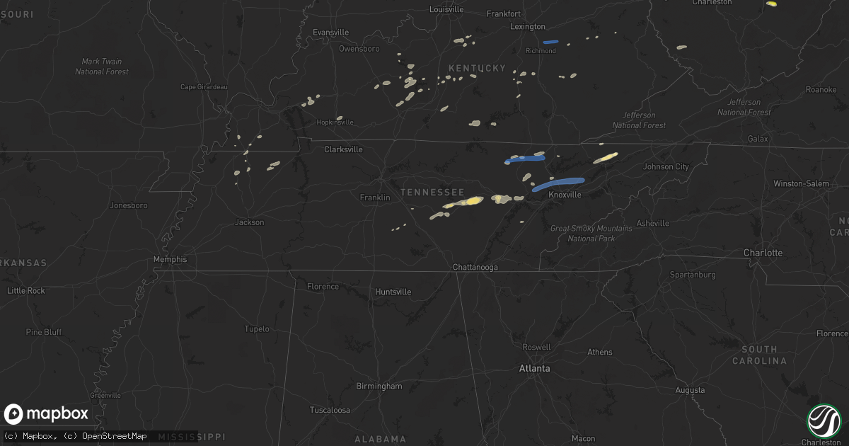
Hail Map in Tennessee on June 21, 2021
Get this storm
June 21 map
$229
one time, instant access
Download today. No call, no setup
Keep the $229
Bought the map and want the full workflow? Apply the entire $229 to a subscription within 7 days. None of it is wasted.
Every map, not just this one
This buys you this map. Subscription and you get every map we run, in the markets you choose from a few cities to whole states to nationwide. Plus real-time alerts the moment a storm fires.
Contact data
Name, contact info, occupancy, even credit band for addresses in the footprint. You go from where it hit to who to call.
Become the source they trust
Unlimited branding weather history reports on demand. You already have the documented answer ready for the property owner, and you are the one who showed up with it.
Property data and RoofTrace estimates
Pull up any address you have got, its value and the exact code rules for that jurisdiction, straight from One Click Code. Then RoofTrace estimates the squares, pitch, and roof value, priced the way you price.
Storm reports in Tennessee
Tennessee
| Date | Description |
|---|---|
| 06/21/20216:42 PM CDT | Several trees down near the rockwood area. |
| 06/21/20216:35 PM CDT | Numerous trees and powerlines down throughout the county... Rockwood area hit the hardest. |
| 06/21/20216:17 PM CDT | Several trees down in the crab orchard community |
| 06/21/20216:13 PM CDT | Trees down across the area. |
| 06/21/20216:12 PM CDT | Several trees down across the county. |
| 06/21/20216:06 PM CDT | Report from mping: 1-inch tree limbs broken; shingles blown off. |
| 06/21/20216:04 PM CDT | Several trees down along lantana rd |
| 06/21/20215:36 PM CDT | Large tree down on sr 285 |
| 06/21/20215:35 PM CDT | Several trees down across northern monroe county. |
| 06/21/20215:34 PM CDT | Large tree down on scotts gulf road |
| 06/21/20215:25 PM CDT | Large tree down on north robin hood rd. |
| 06/21/20215:18 PM CDT | Several trees down near the clairfield area. |
| 06/21/20215:17 PM CDT | Several trees down across the county. |
| 06/21/20215:12 PM CDT | Severe trees down. |
| 06/21/20215:07 PM CDT | A few trees down. |
| 06/21/20214:51 PM CDT | A few trees down. |
| 06/21/20214:51 PM CDT | Report from mping: 1-inch tree limbs broken; shingles blown off. |
| 06/21/20214:50 PM CDT | Tree down along mcminnville hwy |
| 06/21/20214:50 PM CDT | Numerous trees down across north knox county. |
| 06/21/20214:47 PM CDT | A few trees down and minor metal roofing damage in pulaski. |
| 06/21/20214:29 PM CDT | Few trees down. |
| 06/21/20214:28 PM CDT | Several trees down across the south end of the county. |
| 06/21/20214:25 PM CDT | Scattered to numerous trees down throughout the county in addition to downed powerlines. |
| 06/21/20214:24 PM CDT | Couple trees down. |
| 06/21/20214:15 PM CDT | A few trees down. |
| 06/21/20214:09 PM CDT | A few trees down. |
| 06/21/20214:08 PM CDT | A local report indicates 1.50 inch wind near 3 N TREADWAY |
| 06/21/20213:45 PM CDT | A few trees down. |
| 06/21/20213:14 PM CDT | A few trees down in the livingston area. |
| 06/21/20212:44 PM CDT | Tree blown down across a powerline. |
| 06/21/20212:25 PM CDT | Trees down in parts of the county including hwy 47 in charlotte and cumberland furnace. |
| 06/21/20212:20 PM CDT | Facebook report showed a destroyed shed in tennessee city. |
| 06/21/20212:41 AM CDT | At 741 PM EDT, a severe thunderstorm was located over Midtown, or near Rockwood, moving east at 45 mph. HAZARD...60 mph wind gusts and nickel size hail. SOURCE...Radar indicated. IMPACT...Expect damage to roofs, siding, and trees. Locations impacted include... Knoxville, Oak Ridge, Maryville, Clinton, Lenoir City, Alcoa, Kingston, Loudon, Farragut and Oliver Springs.This includes the following highways... Interstate 40 in Tennessee between mile markers 358 and 386. Interstate 75 in Tennessee between mile markers 76 and 123. |
| 06/21/20212:31 AM CDT | At 729 PM EDT, severe thunderstorms were located along a line extending from 15 miles southeast of Maryville to 11 miles northwest of Murphy, moving east at 30 mph. HAZARD...60 mph wind gusts. SOURCE...Radar indicated. IMPACT...Expect damage to trees and power lines. Locations impacted include... Robbinsville, Town Of Santeetlah, Lake Santeetlah, Fontana Lake, Fontana Village, Stecoah, Nantahala, and a portion of the Smoky Mountains, near Newfound Gap, Twentymile Creek, and in the Fontana Area. |
| 06/21/20212:19 AM CDT | At 719 PM EDT, a severe thunderstorm was located 7 miles south of Fairfield Glade, or 9 miles southeast of Crossville, moving east at 25 mph. HAZARD...60 mph wind gusts and nickel size hail. SOURCE...Radar indicated. IMPACT...Expect damage to roofs, siding, and trees. Locations impacted include... Oak Ridge, Kingston, Rockwood, Fairview, Midtown, Harriman, Oakdale, Coalfield, Eagle Furnace and Pine Orchard.This includes Interstate 40 in Tennessee between mile markers 341 and358. |
| 06/21/20211:54 AM CDT | At 653 PM EDT, a severe thunderstorm was located near Louisville, or near Alcoa, moving east at 20 mph. HAZARD...60 mph wind gusts and penny size hail. SOURCE...Radar indicated. IMPACT...Expect damage to roofs, siding, and trees. Locations impacted include... Knoxville, Maryville, Alcoa, Pigeon Forge, Louisville, Rockford, Eagleton Village, Friendsville, Kimberlin Heights and Wildwood.This includes Interstate 40 in Tennessee between mile markers 378 and389, and between mile markers 400 and 406. |
| 06/21/20211:02 AM CDT | At 601 PM EDT, severe thunderstorms were located along a line extending from 7 miles west of New Tazewell to 6 miles southwest of Rutledge to New Market to 9 miles north of Sevierville to 8 miles east of Knoxville, moving east at 45 mph. HAZARD...60 mph wind gusts and penny size hail. SOURCE...Radar indicated. IMPACT...Expect damage to roofs, siding, and trees. Locations impacted include... Morristown, Greeneville, Jefferson City, Newport, Rogersville, Dandridge, Rutledge, Bean Station, White Pine and New Market.This includes the following highways... Interstate 40 in Tennessee between mile markers 410 and 435. Interstate 81 in Tennessee between mile markers 1 and 34. |
| 06/21/202112:57 AM CDT | At 557 PM CDT, a severe thunderstorm was located near Crossville, moving east at 40 mph. HAZARD...60 mph wind gusts. SOURCE...Radar indicated. IMPACT...Expect damage to roofs, siding, and trees. Locations impacted include... Crossville, Fairfield Glade, Crab Orchard, Pleasant Hill, Lake Tansi, Cumberland Mountain State Park, Slate Springs and Indian Rock Lake.This includes Interstate 40 between mile markers 306 and 339. |
| 06/21/202112:42 AM CDT | At 541 PM EDT, a severe thunderstorm was located 8 miles south of Zion Hill, or 9 miles northwest of La Follette, moving east at 45 mph. HAZARD...60 mph wind gusts and quarter size hail. SOURCE...Radar indicated. IMPACT...Hail damage to vehicles is expected. Expect wind damage to roofs, siding, and trees. Locations impacted include... Harrogate, Jellico, Elk Valley, Cumberland Gap, Arthur, Indian Mountain State Park, Clairfield and White Oak.This includes Interstate 75 in Tennessee between mile markers 142 and161. |
| 06/21/202112:36 AM CDT | At 536 PM EDT, a severe thunderstorm was located near Clinton, moving east at 40 mph. HAZARD...60 mph wind gusts and nickel size hail. SOURCE...Radar indicated. IMPACT...Expect damage to roofs, siding, and trees. Locations impacted include... Knoxville, Jefferson City, New Market, Strawberry Plains, Halls, Blaine, Maloneyville, Mascot, Piedmont and Powell.This includes the following highways... Interstate 40 in Tennessee between mile markers 389 and 405, andbetween mile markers 410 and 413. Interstate 75 in Tennessee between mile markers 108 and 114. |
| 06/21/202112:29 AM CDT | At 528 PM EDT, a severe thunderstorm was located 7 miles northeast of Clinton, moving east at 40 mph. HAZARD...60 mph wind gusts and penny size hail. SOURCE...Radar indicated. IMPACT...Expect damage to roofs, siding, and trees. Locations impacted include... Maynardville, Rutledge, Plainview, Halls, Blaine, Luttrell, Rose Hill, Buffalo Springs, Paulette and Big Ridge State Park.This includes Interstate 75 in Tennessee between mile markers 114 and117. |
| 06/21/202112:22 AM CDT | At 522 PM CDT, a severe thunderstorm was located 9 miles northwest of Spencer, moving east at 40 mph. HAZARD...60 mph wind gusts. SOURCE...Radar indicated. IMPACT...Expect damage to roofs, siding, and trees. Locations impacted include... McMinnville, Sparta, Spencer, Pleasant Hill, Doyle, Fall Creek Falls State Park, Indian Rock Lake, Virgin Falls State Natural Area and Rock Island State Park. |
| 06/21/202112:17 AM CDT | At 517 PM EDT, a severe thunderstorm was located near Fonde, or near Middlesboro, moving east at 35 mph. HAZARD...60 mph wind gusts. SOURCE...Radar indicated. IMPACT...Expect damage to roofs, siding, and trees. This severe thunderstorm will be near... Middlesboro around 525 PM EDT. Binghamtown around 530 PM EDT.Other locations in the path of this severe thunderstorm includeHutch. |
| 06/21/202112:05 AM CDT | At 504 PM EDT, a severe thunderstorm was located 10 miles southwest of Helenwood, or 13 miles southeast of Jamestown, moving east at 45 mph. HAZARD...70 mph wind gusts and nickel size hail. SOURCE...Radar indicated. IMPACT...Expect considerable tree damage. Damage is likely to mobile homes, roofs, and outbuildings. Locations impacted include... Oneida, Huntsville, Helenwood, Rugby, Elk Valley, Rugby State Park, Honey Creek State Park, Royal Blue, Norma and Elgin.This includes Interstate 75 in Tennessee between mile markers 143 and151. |
| 06/20/202111:55 PM CDT | At 454 PM EDT, a severe thunderstorm was located 7 miles east of Wartburg, moving northeast at 35 mph. HAZARD...60 mph wind gusts and penny size hail. SOURCE...Radar indicated. IMPACT...Expect damage to roofs, siding, and trees. Locations impacted include... Oak Ridge, Clinton, La Follette, Wartburg, Oliver Springs, Jacksboro, Harriman, Caryville, Rocky Top and Norris.This includes Interstate 75 in Tennessee between mile markers 118 and142. |
| 06/20/202111:44 PM CDT | At 444 PM CDT, a severe thunderstorm was located near Woodbury, moving east at 40 mph. HAZARD...60 mph wind gusts. SOURCE...Radar indicated. IMPACT...Expect damage to roofs, siding, and trees. Locations impacted include... McMinnville, Woodbury, Centertown and Rock Island State Park. |
| 06/20/202111:29 PM CDT | At 428 PM EDT, a severe thunderstorm was located 8 miles east of Fairfield Glade, or 9 miles southwest of Wartburg, moving northeast at 35 mph. HAZARD...60 mph wind gusts and nickel size hail. SOURCE...Radar indicated. IMPACT...Expect damage to roofs, siding, and trees. Locations impacted include... Wartburg, Sunbright, Oakdale, Coalfield, Pine Orchard, Frozen Head State Park and Petros. |
| 06/20/202110:40 PM CDT | At 339 PM CDT, a severe thunderstorm was located 9 miles southwest of Jamestown, moving east at 45 mph. HAZARD...60 mph wind gusts. SOURCE...Radar indicated. IMPACT...Expect damage to roofs, siding, and trees. Locations impacted include... Jamestown, Allardt, Crawford and Grimsley. |
| 06/20/20219:38 PM CDT | At 237 PM CDT, a severe thunderstorm was located 7 miles east of Carthage, moving northeast at 45 mph. HAZARD...60 mph wind gusts. SOURCE...Radar indicated. IMPACT...Expect damage to roofs, siding, and trees. Locations impacted include... Livingston, Carthage, Celina, Gainesboro, Whitleyville, Granville, Cummins Falls State Park and Standing Stone State Park.This includes Interstate 40 near mile marker 266. |
| 06/20/20219:36 PM CDT | At 235 PM CDT, a severe thunderstorm was located 8 miles west of Ashland City, moving east at 40 mph. HAZARD...60 mph wind gusts. SOURCE...Radar indicated. IMPACT...Expect damage to roofs, siding, and trees. Locations impacted include... Ashland City, Nashville, Goodlettsville, Forest Hills, Oak Hill, White Bluff, Belle Meade, Kingston Springs, Pegram, Joelton, Pleasant View, Berry Hill, Cheatham Dam, Bells Bend, Whites Creek and Beaman Park.This includes the following highways... Interstate 40 between mile markers 197 and 213. Interstate 65 between mile markers 77 and 93. Interstate 24 between mile markers 29 and 53. |
| 06/20/20219:05 PM CDT | At 205 PM CDT, severe thunderstorms were located along a line extending from 13 miles east of Erin to near Waverly, moving east at 30 mph. HAZARD...60 mph wind gusts. SOURCE...Radar indicated. IMPACT...Expect damage to roofs, siding, and trees. Locations impacted include... Dickson, Waverly, Erin, McEwen, Burns, Charlotte, Vanleer, Slayden and Cheatham Dam. |
| 06/20/20219:04 PM CDT | At 204 PM CDT, a severe thunderstorm was located near Watertown, or 11 miles southeast of Lebanon, moving northeast at 40 mph. HAZARD...60 mph wind gusts. SOURCE...Radar indicated. IMPACT...Expect damage to roofs, siding, and trees. Locations impacted include... Lebanon, Carthage, Watertown, Gordonsville, Hickman, South Carthage, Alexandria, Cedars Of Lebanon State Park, Center Hill Lake, Tuckers Crossroads and Edgar Evans State Park.This includes Interstate 40 between mile markers 241 and 266. |
| 06/20/20217:05 PM CDT | Tree down on campbell station rd and powerlines down on guinn rd. |
All States Impacted by Hail Map on June 21, 2021
Cities Impacted by Hail Map on June 21, 2021
- Mount Pleasant, AR
- Marlin, TX
- Madisonville, TX
- Ledbetter, TX
- Round Top, TX
- Compton, AR
- Green Forest, AR
- Berryville, AR
- Alpena, AR
- Chestertown, MD
- Worton, MD
- Boone, NC
- Blowing Rock, NC
- Babson Park, FL
- Lake Wales, FL
- Jackman, ME
- Fort Stockton, TX
- Marathon, TX
- Berryville, VA
- Bluemont, VA
- Salado, TX
- Paint Rock, TX
- Rowena, TX
- Falls Of Rough, KY
- Fredericksburg, TX
- Colebrook, NH
- Tamaqua, PA
- Coaldale, PA
- Nesquehoning, PA
- Chambersburg, PA
- Greencastle, PA
- Paris, TN
- Cottage Grove, TN
- Puryear, TN
- Knob Lick, KY
- Glasgow, KY
- Grantsville, WV
- Summersville, WV
- Craigsville, WV
- Kerrville, TX
- Allardt, TN
- Jamestown, TN
- Winfield, WV
- Scott Depot, WV
- Wilcox, PA
- Ferrisburgh, VT
- Harrisburg, PA
- Bristol, VT
- Waitsfield, VT
- Starksboro, VT
- Dorset, OH
- Andover, OH
- Jefferson, OH
- Iola, TX
- Bedias, TX
- Everton, AR
- Hudson Falls, NY
- Florence, TX
- Cortland, NY
- Freeville, NY
- Bernhards Bay, NY
- Cleveland, NY
- Rogersville, TN
- Thorn Hill, TN
- Sneedville, TN
- Mooresburg, TN
- Sparta, TN
- Jersey Shore, PA
- Poca, WV
- Hurricane, WV
- Red House, WV
- Saint Albans, WV
- Nitro, WV
- Charleston, WV
- Ozona, TX
- Muncy Valley, PA
- Forksville, PA
- Dushore, PA
- Stonewall, TX
- Edinburg, VA
- Marble Falls, TX
- Spicewood, TX
- Vincent, KY
- Booneville, KY
- Tuttle, OK
- Blanchard, OK
- Orwell, OH
- Bardstown, KY
- Coxs Creek, KY
- Boston, KY
- Shepherdsville, KY
- Leitchfield, KY
- Hornersville, MO
- Llano, TX
- Dryden, TX
- Ballinger, TX
- Piseco, NY
- Lake Pleasant, NY
- Wellington, KY
- Frenchburg, KY
- Dallas, WV
- Wheeling, WV
- Moundsville, WV
- Belton, TX
- Fulton, KY
- McKee, KY
- Williamsfield, OH
- Rome, OH
- Liberty Hill, TX
- Rockwood, TN
- Harriman, TN
- Waelder, TX
- Flatonia, TX
- Gonzales, TX
- Shiner, TX
- Mcminnville, TN
- Quebeck, TN
- Crossville, TN
- Walling, TN
- Smithville, TN
- Rock Island, TN
- Doyle, TN
- Bolivar, NY
- Shinglehouse, PA
- Ceres, NY
- Alma, NY
- Little Genesee, NY
- Eldred, PA
- Wellsville, NY
- Herndon, PA
- Gratz, PA
- Klingerstown, PA
- Lykens, PA
- Reno, OH
- Newport, OH
- Marietta, OH
- Williamstown, WV
- Whipple, OH
- Rising Star, TX
- Johnson City, TX
- Orrtanna, PA
- Middlebury, VT
- North Ferrisburgh, VT
- New Haven, VT
- Vergennes, VT
- Ponca, AR
- Iraan, TX
- Shelbyville, TN
- Tipton, OK
- Martinsville, OH
- Lynchburg, OH
- Hillsboro, OH
- Midland, OH
- New Vienna, OH
- Fenwick, WV
- Campbellsville, KY
- Homer, NY
- Cub Run, KY
- Mammoth Cave, KY
- Durhamville, NY
- Portville, NY
- Hopkinsville, KY
- Reagan, TX
- Crab Orchard, TN
- Cairo, WV
- Rochelle, TX
- Belleville, WV
- Mineral Wells, WV
- Danville, AR
- Waynesburg, KY
- Murfreesboro, TN
- Kissimmee, FL
- Bonnieville, KY
- Magnolia, KY
- Brownsville, KY
- Bowling Green, KY
- Sweetwater, TN
- Niota, TN
- Headrick, OK
- Kenansville, FL
- Comstock, TX
- Ozark, AR
- Ratcliff, AR
- Cold Brook, NY
- Lebanon, KY
- Jarrell, TX
- Schroon Lake, NY
- North Hudson, NY
- Granville, NY
- Boyce, VA
- College Station, TX
- Smethport, PA
- Groton, NY
- Fairfield, PA
- Kenton, TN
- Spencer, NY
- Van Etten, NY
- Cayuta, NY
- Erin, NY
- Jamestown, KY
- Burkesville, KY
- Rockport, WV
- Ravenswood, WV
- Rocksprings, TX
- Fort Pierce, FL
- North Zulch, TX
- Anderson, TX
- Troy, NY
- Burnet, TX
- Danville, PA
- Sunbury, PA
- Bloomfield, KY
- Horseshoe Bay, TX
- Ashland, ME
- Mountain View, AR
- Beaver Dam, KY
- Dawson Springs, KY
- Elkview, WV
- Summersville, KY
- Yellville, AR
- Alicia, AR
- Walnut Ridge, AR
- Melrose, NY
- Mechanicville, NY
- Schaghticoke, NY
- Queensbury, NY
- Fort Ann, NY
- Sebring, FL
- Hartstown, PA
- Conneaut Lake, PA
- Atlantic, PA
- Taberg, NY
- Crab Orchard, KY
- Stanford, KY
- Holland, TX
- Temple, TX
- Rogers, TX
- Lovelady, TX
- Schulenburg, TX
- Leander, TX
- Bertram, TX
- Big Bend, WV
- Normantown, WV
- Glenville, WV
- Arnoldsburg, WV
- Big Springs, WV
- Dunbar, WV
- South Charleston, WV
- Fraziers Bottom, WV
- Eleanor, WV
- Ezel, KY
- Saint Cloud, FL
- Thurmont, MD
- Rocky Ridge, MD
- Rome, NY
- Blossvale, NY
- Canastota, NY
- Oneida, NY
- Triadelphia, WV
- Valley Grove, WV
- Pioneer, TN
- Oneida, TN
- Navasota, TX
- Willow City, TX
- Clinton, KY
- South Fulton, TN
- Grapeland, TX
- Crockett, TX
- Nixon, TX
- Caribou, ME
- Fort Fairfield, ME
- West Liberty, KY
- Elkfork, KY
- Carmine, TX
- Burton, TX
- Daytona Beach, FL
- Ormond Beach, FL
- Sharon, TN
- Martin, TN
- Munfordville, KY
- Rocky Top, TN
- Clinton, TN
- Barksdale, TX
- Mapleton, ME
- Clarkson, KY
- Moriah, NY
- Port Henry, NY
- Crown Point, NY
- Lancing, TN
- Wartburg, TN
- Sheffield, TX
- Rosebud, TX
- Burlington, TX
- Stanton, KY
- Round Mountain, TX
- Ferguson, NC
- La Follette, TN
- Carlsbad, TX
- West Alexander, PA
- Claysville, PA
- Camden, NY
- Constantia, NY
- Ava, NY
- Lee Center, NY
- Waynesboro, PA
- Olustee, OK
- Mangum, OK
- Duke, OK
- Altus, OK
- Ingram, TX
- Helenwood, TN
- Robbins, TN
- Manila, AR
- Lott, TX
- Elmer, OK
- Frederick, OK
- May, TX
- Tazewell, TN
- Oliver Springs, TN
- Sharpsburg, MD
- Keedysville, MD
- Coolville, OH
- Guysville, OH
- Stewart, OH
- Athens, OH
- Cutler, OH
- McKenzie, TN
- Henry, TN
- Gleason, TN
- Purlear, NC
- Deep Gap, NC
- Fort Valley, VA
- Mayfield, KY
- Del Rio, TX
- Bell Buckle, TN
- La Grange, TX
- Little York, NY
- Preble, NY
- Vanderpool, TX
- Leakey, TX
- Eubank, KY
- Science Hill, KY
- Ithaca, NY
- Mechanicstown, OH
- Carrollton, OH
- Windsor, OH
- Wingo, KY
- Water Valley, KY
- Prairie Grove, AR
- Lithia, FL
- Mulberry, FL
- Plant City, FL
- Trout Run, PA
- Liberty, PA
- Morgantown, WV
- Fairmont, WV
- Morrison, TN
- Mount Enterprise, TX
- Princeton, KY
- Trenton, FL
- Bangor, PA
- Mount Bethel, PA
- Columbia, NJ
- Albany, KY
- Monticello, KY
- Alpha, KY
- Kings Mountain, KY
- Dyer, TN
- Reedsville, OH
- Walker, WV
- Elizabeth, WV
- Port Saint Lucie, FL
- Buchanan Dam, TX
- Killeen, TX
- Georgetown, TX
- Blossburg, PA
- Morris, PA
- Eidson, TN
- Round Hill, VA
- Harpers Ferry, WV
- Athens, AL
- Leesville, TX
- Meadville, PA
- Cochranton, PA
- Delbarton, WV
- Logan, WV
- North Wilkesboro, NC
- McGrady, NC
- Caneyville, KY
- Grantville, PA
- Annville, PA
- Brodhead, KY
- Kattskill Bay, NY
- Lake George, NY
- Middleburg, VA
- Marshall, VA
- The Plains, VA
- Roundhill, KY
- Bee Spring, KY
- Waverly, WV
- Leachville, AR
- Camp Wood, TX
- Hardinsburg, KY
- Hunt, TX
- Richford, NY
- Marathon, NY
- Adamsville, PA
- Jamestown, PA
- Cromwell, KY
- Horse Branch, KY
- Morgantown, KY
- Huntington, AR
- Mansfield, AR
- Washburn, ME
- Beaver Dams, NY
- Linesville, PA
- Salineville, OH
- White Post, VA
- Front Royal, VA
- Strasburg, VA
- Upperville, VA
- Stephens City, VA
- Winchester, VA
- Paris, VA
- Leesburg, VA
- Middletown, VA
- Purcellville, VA
- Guildhall, VT
- Errol, NH
- Lakeland, FL
- Waco, KY
- Richmond, KY
- Irvine, KY
- Winchester, KY
- Clay City, KY
- Caryville, TN
- Huntsville, TN
- New Market, TN
- Oak Ridge, TN
- Knoxville, TN
- Mascot, TN
- Luttrell, TN
- Powell, TN
- Blaine, TN
- Strawberry Plains, TN
- Heiskell, TN
- Corryton, TN
- Tully, NY
- De Ruyter, NY
- Whitehall, NY
- Palestine, WV
- Calvin, WV
- Carthage, NY
- Natural Bridge, NY
- Harrisville, NY
- Castorland, NY
- Lowville, NY
- Croghan, NY
- Caledonia, NY
- Lakeville, NY
- Minetto, NY
- Farmington, NY
- North Rose, NY
- Macedon, NY
- Mendon, NY
- Piffard, NY
- Sterling, NY
- York, NY
- Altmar, NY
- Retsof, NY
- Wolcott, NY
- Honeoye Falls, NY
- Lima, NY
- Pulaski, NY
- Le Roy, NY
- Marion, NY
- Hannibal, NY
- Leicester, NY
- Walworth, NY
- Rush, NY
- Martville, NY
- Ionia, NY
- Lyons, NY
- Fairport, NY
- Livonia, NY
- Williamson, NY
- Pavilion, NY
- Fulton, NY
- Avon, NY
- Victor, NY
- Wyoming, NY
- Mexico, NY
- Pittsford, NY
- Palmyra, NY
- Bloomfield, NY
- Red Creek, NY
- Shortsville, NY
- Sodus Point, NY
- Richland, NY
- Sodus, NY
- Geneseo, NY
- West Bloomfield, NY
- Linwood, NY
- Newark, NY
- Oswego, NY
- Island Pond, VT
- Saint Johnsbury, VT
- Danville, VT
- Concord, VT
- Littleton, NH
- East Liverpool, OH
- Industry, PA
- Lisbon, OH
- Midland, PA
- Wellsville, OH
- Hammondsville, OH
- Apollo, PA
- Beaver, PA
- Penn Run, PA
- Mars, PA
- Bairdford, PA
- Homer City, PA
- Tarentum, PA
- Conway, PA
- Blairsville, PA
- Northern Cambria, PA
- Dilltown, PA
- Natrona Heights, PA
- Leechburg, PA
- Josephine, PA
- Cheswick, PA
- Hyde Park, PA
- Saltsburg, PA
- Avonmore, PA
- Twin Rocks, PA
- Warrendale, PA
- Wexford, PA
- Strongstown, PA
- Nicktown, PA
- Bakerstown, PA
- Nanty Glo, PA
- Cranberry Township, PA
- Belsano, PA
- Colver, PA
- East Vandergrift, PA
- Armagh, PA
- Indiana, PA
- Russellton, PA
- Coral, PA
- Monaca, PA
- New Kensington, PA
- Brackenridge, PA
- Freedom, PA
- Creighton, PA
- Carrolltown, PA
- Vintondale, PA
- Clune, PA
- Gibsonia, PA
- North Apollo, PA
- Clarksburg, PA
- Valencia, PA
- Baden, PA
- Vandergrift, PA
- Brush Valley, PA
- Ebensburg, PA
- Shelocta, PA
- Spring Church, PA
- Irwin, PA
- Adamsburg, PA
- Jeannette, PA
- Westmoreland City, PA
- Larimer, PA
- Rillton, PA
- Herminie, PA
- Pleasant Unity, PA
- West Newton, PA
- New Stanton, PA
- Arona, PA
- Greenock, PA
- Madison, PA
- Ruffs Dale, PA
- Homestead, PA
- North Versailles, PA
- Dravosburg, PA
- Youngwood, PA
- Duquesne, PA
- Mount Pleasant, PA
- Darragh, PA
- West Mifflin, PA
- Latrobe, PA
- Glassport, PA
- Pittsburgh, PA
- Hunker, PA
- Greensburg, PA
- Mckeesport, PA
- Yukon, PA
- Bellefonte, PA
- Avis, PA
- Lock Haven, PA
- Howard, PA
- Julian, PA
- Blanchard, PA
- Mill Hall, PA
- Beech Creek, PA
- Williamsport, PA
- Linden, PA
- Towanda, PA
- Monroeton, PA
- New Albany, PA


