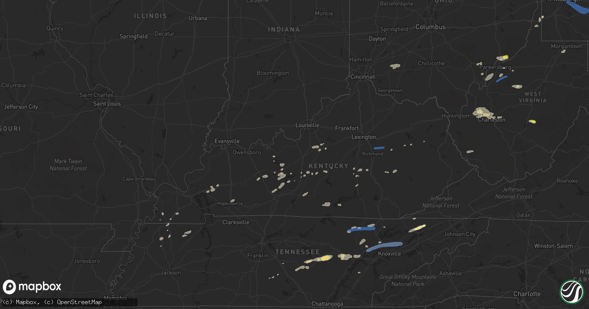
Hail Map in Kentucky on June 21, 2021
Get this storm
June 21 map
$229
one time, instant access
Download today. No call, no setup
Keep the $229
Bought the map and want the full workflow? Apply the entire $229 to a subscription within 7 days. None of it is wasted.
Every map, not just this one
This buys you this map. Subscription and you get every map we run, in the markets you choose from a few cities to whole states to nationwide. Plus real-time alerts the moment a storm fires.
Contact data
Name, contact info, occupancy, even credit band for addresses in the footprint. You go from where it hit to who to call.
Become the source they trust
Unlimited branding weather history reports on demand. You already have the documented answer ready for the property owner, and you are the one who showed up with it.
Property data and RoofTrace estimates
Pull up any address you have got, its value and the exact code rules for that jurisdiction, straight from One Click Code. Then RoofTrace estimates the squares, pitch, and roof value, priced the way you price.
Storm reports in Kentucky
Kentucky
| Date | Description |
|---|---|
| 06/21/20215:40 PM CDT | Trees down across road on cloverlick creek. |
| 06/21/20214:47 PM CDT | Tree reported down on hwy 1524. Time estimated from radar. |
| 06/21/20214:34 PM CDT | Tree down along ky 1304 near intersection with us-25. |
| 06/21/20214:30 PM CDT | Tree across owsley fork road. |
| 06/21/20214:29 PM CDT | Tree down on kentucky 459 near intersection ky-11. |
| 06/21/20214:27 PM CDT | Trees down on hurst road off of hwy 119. |
| 06/21/20214:27 PM CDT | Tree down on happy hollow road. |
| 06/21/20214:19 PM CDT | Tree limbs reported down along with damage to a roof. Time estimated from radar. |
| 06/21/20214:08 PM CDT | Tree down on a powerline near the intersection of twin branch road and kentucky state highway 638. |
| 06/21/20213:55 PM CDT | Tree down across ky-1955 between mm 1 and 2. |
| 06/21/20213:48 PM CDT | Floyd county 911 call center reports downed tree blocking highway 194 on a hill near cow creek. Time estimated from radar. |
| 06/21/20213:42 PM CDT | Large tree branch partially blocking valley view road. |
| 06/21/20213:40 PM CDT | Tree down near the intersection of west main street and old somerset road. |
| 06/21/20213:32 PM CDT | Magoffin county 911 call center reported downed tree on highway 7 near intersection with straight fork rd. |
| 06/21/20213:27 PM CDT | Trees reported down along jasper st... With one tree down on powerlines near the intersection with mt vernon st. Time estimated from radar. |
| 06/21/20213:27 PM CDT | Trees reported down along ohio st. Time estimated from radar. |
| 06/21/20213:27 PM CDT | Trees reported down at intersection of hope way and railroad dr. Time estimated from radar. |
| 06/21/20213:18 PM CDT | Tree down across ky-257 in confluence. |
| 06/21/20213:18 PM CDT | Wayne county 911 call center reported downed tree blocking highway 1619. Time estimated from radar. |
| 06/21/20213:16 PM CDT | Wayne county 911 call center reported tree down on mobile home and vehicle along tennessee avenue. Time estimated from radar. |
| 06/21/20213:14 PM CDT | Wayne county 911 call center reported tree down on a home along chesney street. Time estimated from radar. |
| 06/21/20213:13 PM CDT | Wayne county 911 call center reported down tree blocking highway 858 near bethesda rd. Time estimated from radar. Time estimated from radar. |
| 06/21/20213:08 PM CDT | Wayne county 911 call center reported downed tree on highway 1720. Time estimated from radar. |
| 06/21/20213:03 PM CDT | Corrects previous tstm wnd dmg report from 2 nw zula. Wayne county 911 call center reported downed tree on highway 1009 near marcum road. Time estimated from radar. |
| 06/21/20212:41 PM CDT | Tree across fish creek loop rd. |
| 06/21/20212:24 PM CDT | Trees down on hwy 587. |
| 06/21/20212:12 PM CDT | Corrects previous tstm wnd dmg report from 1 ssw shirley. Tree across owsley fork road. |
| 06/21/20212:06 PM CDT | Tree down over road along byrd ridge rd. At route 3342. |
| 06/21/20212:03 PM CDT | Tree down along hwy 421. |
| 06/21/20211:56 PM CDT | Photos of a tree down with some damage to an outdoor structure. Time estimated from radar. |
| 06/21/20211:51 PM CDT | Photos of trees and limbs down in roundstone. Time estimated from radar. |
| 06/21/20211:49 PM CDT | Lexington/hazard news media report 100-foot tall antenna tower blown down onto home. Roof was dented... But no apparent structural damage to home. Time estimated from r |
| 06/21/20211:49 PM CDT | Rockcastle county 911 call center reports downed tree near intersection of old sigmon loop and us-25. Time estimated from radar. |
| 06/21/20211:48 PM CDT | Corrects previous tstm wnd dmg report from 1 sw mount vernon. Tree down near the intersection of west main street and old somerset road. |
| 06/21/20211:46 PM CDT | Rockcastle county 911 call center reported downed tree on road near intersection of mount zion and renfro creek rd. Time estimated from radar. |
| 06/21/20211:42 PM CDT | Trees down along state hwy 643 near crab orchard. |
| 06/21/20211:40 PM CDT | Tree down along highway 615. Time estimated from radar. |
| 06/21/20211:38 PM CDT | Nws employee reports a large tree snapped along pompeii road near the intersection with thorpe ridge rd. Event time estimated from radar. |
| 06/21/20211:29 PM CDT | Tree down. |
| 06/21/20211:28 PM CDT | Corrects previous tstm wnd dmg report from 1 n west liberty. Morgan county 911 call center reported trees blown on mobile homes in trailer park just off highway 7. |
| 06/21/20211:25 PM CDT | Corrects previous tstm wnd dmg report from grassy creek. Trees across road at grassy creek with other trees down across the county. |
| 06/21/20211:00 PM CDT | Downed limbs. Also tree on road at pheasant run and autumn ridge dr. City crews have responded where needed. |
| 06/21/20211:00 PM CDT | Tree on power lines. |
| 06/21/20211:00 PM CDT | Tree on road. |
| 06/21/202112:57 PM CDT | Reported trees down and some localized flash flooding in northern part of the county. |
| 06/21/202111:45 AM CDT | Dispatch reported a couple of trees down in the 800 block of taylorsville rd. Time estimated from tdwr. |
| 06/21/202111:41 AM CDT | Horse shed flipped over on blowtown road. |
| 06/21/20217:41 AM CDT | At 1240 PM EDT/1140 AM CDT/, a severe thunderstorm was located near Leitchfield, moving east at 35 mph. HAZARD...60 mph wind gusts and penny size hail. SOURCE...Radar indicated. IMPACT...Expect damage to roofs, siding, and trees. This severe thunderstorm will remain over mainly rural areas of north central Hart, southeastern Grayson and south central Hardin Counties, including the following locations... Spike, Spurrier, Rock Creek, Seven Corners, Peonia, Flint Hill, Snap, Grayson Springs, Royal and Skaggstown. |
| 06/21/202112:57 AM CDT | At 557 PM EDT, a severe thunderstorm was located near Tazewell, or 11 miles southeast of Middlesboro, moving east at 40 mph. HAZARD...60 mph wind gusts and penny size hail. SOURCE...Radar indicated. IMPACT...Expect damage to roofs, siding, and trees. Locations impacted include... Sneedville, New Tazewell, Tazewell, Harrogate, Lone Mountain, Howard Quarter, Evanston, Arthur, Powell River Preserve and Kyles Ford. |
| 06/21/202112:53 AM CDT | At 553 PM EDT, a severe thunderstorm was located 8 miles southeast of Cubage, or 12 miles northwest of Sneedville, moving east at 40 mph. HAZARD...60 mph wind gusts and penny size hail. SOURCE...Radar indicated. IMPACT...Expect damage to roofs, siding, and trees. Locations impacted include... Sneedville, Jonesville, Pennington Gap, Jasper, Ewing, Dryden, Rose Hill, Kyles Ford and Pattonsville. |
| 06/21/202112:25 AM CDT | At 525 PM EDT, a severe thunderstorm was located over Permon, or near Barbourville, moving east at 40 mph. HAZARD...60 mph wind gusts. SOURCE...Radar indicated. IMPACT...Expect damage to roofs, siding, and trees. This severe thunderstorm will be near... Swan Lake around 530 PM EDT. Barbourville around 535 PM EDT. Artemus around 540 PM EDT. Old Flat Lick around 545 PM EDT.Other locations in the path of this severe thunderstorm includeWalker and Rella. |
| 06/21/202112:12 AM CDT | At 512 PM EDT, a severe thunderstorm was located 8 miles south of Pruden, or 13 miles northeast of La Follette, moving east at 45 mph. HAZARD...60 mph wind gusts and penny size hail. SOURCE...Radar indicated. IMPACT...Expect damage to roofs, siding, and trees. Locations impacted include... New Tazewell, Tazewell, Harrogate, Springdale, Howard Quarter, Cumberland Gap, Arthur, Clairfield and Powell River Preserve. |
| 06/20/202111:56 PM CDT | At 456 PM EDT, a severe thunderstorm was located over Hazel Patch, or 9 miles northwest of London, moving east at 50 mph. HAZARD...60 mph wind gusts. SOURCE...Radar indicated. IMPACT...Expect damage to roofs, siding, and trees. This severe thunderstorm will be near... Mershons around 500 PM EDT. Peoples around 505 PM EDT. Moores Creek around 510 PM EDT. Welchburg around 515 PM EDT.Other locations in the path of this severe thunderstorm includeMaulden and Island City. |
| 06/20/202111:42 PM CDT | At 442 PM EDT, a severe thunderstorm was located over Cliff, or over Prestonsburg, moving east at 35 mph. HAZARD...60 mph wind gusts. SOURCE...Radar indicated. IMPACT...Expect damage to roofs, siding, and trees. This severe thunderstorm will be near... Bays Branch around 445 PM EDT. Corn Fork Hollow around 450 PM EDT. Dicks Creek around 455 PM EDT. McCombs around 500 PM EDT.Other locations in the path of this severe thunderstorm includePleasant. |
| 06/20/202111:34 PM CDT | At 434 PM EDT, a severe thunderstorm was located over Bent, or 7 miles east of Somerset, moving east at 55 mph. HAZARD...60 mph wind gusts. SOURCE...Radar indicated. IMPACT...Expect damage to roofs, siding, and trees. This severe thunderstorm will be near... Billows around 445 PM EDT. Bernstadt around 450 PM EDT.Other locations in the path of this severe thunderstorm include Hareand Atlanta. |
| 06/20/202111:28 PM CDT | At 428 PM EDT, a severe thunderstorm was located over Duco, or 11 miles south of Salyersville, moving east at 25 mph. HAZARD...60 mph wind gusts. SOURCE...Radar indicated. IMPACT...Expect damage to roofs, siding, and trees. This severe thunderstorm will be near... Gapville around 435 PM EDT. Orchard around 440 PM EDT. Pyramid around 445 PM EDT.Other locations in the path of this severe thunderstorm include BlueRiver, Dock and Martin. |
| 06/20/202111:18 PM CDT | At 418 PM EDT, a severe thunderstorm was located near Frazer, or near Somerset, moving east at 45 mph. HAZARD...60 mph wind gusts. SOURCE...Radar indicated. IMPACT...Expect damage to roofs, siding, and trees. This severe thunderstorm will be near... Burnside around 425 PM EDT. Somerset around 430 PM EDT. Grade around 435 PM EDT.Other locations in the path of this severe thunderstorm includeDykes. |
| 06/20/202111:08 PM CDT | At 408 PM EDT, a severe thunderstorm was located over Parnell, or near Monticello, moving east at 20 mph. HAZARD...60 mph wind gusts. SOURCE...Radar indicated. IMPACT...Expect damage to roofs, siding, and trees. This severe thunderstorm will be near... Monticello around 425 PM EDT.Other locations in the path of this severe thunderstorm includeSteubenville, Mill Springs, Betsey and Frazer. |
| 06/20/202110:55 PM CDT | At 355 PM EDT, a severe thunderstorm was located over Panco, or 11 miles northwest of Hyden, moving east at 35 mph. HAZARD...60 mph wind gusts. SOURCE...Radar indicated. IMPACT...Expect damage to roofs, siding, and trees. This severe thunderstorm will be near... Shoal around 405 PM EDT. Confluence around 410 PM EDT. Krypton around 415 PM EDT.Other locations in the path of this severe thunderstorm includeHazard. |
| 06/20/202110:41 PM CDT | At 341 PM EDT, a severe thunderstorm was located over Booneville, moving east at 40 mph. HAZARD...60 mph wind gusts. SOURCE...Radar indicated. IMPACT...Expect damage to roofs, siding, and trees. This severe thunderstorm will be near... Lerose around 345 PM EDT. Athol around 350 PM EDT. Oakdale around 355 PM EDT. Gentry around 400 PM EDT.Other locations in the path of this severe thunderstorm includeJackson and Keck. |
| 06/20/202110:22 PM CDT | At 322 PM EDT, a severe thunderstorm was located over Nathanton, or 8 miles southeast of McKee, moving northeast at 35 mph. HAZARD...60 mph wind gusts. SOURCE...Radar indicated. IMPACT...Expect damage to roofs, siding, and trees. This severe thunderstorm will be near... Green Hall around 325 PM EDT. Sturgeon around 330 PM EDT. Endee around 335 PM EDT. Booneville around 340 PM EDT.Other locations in the path of this severe thunderstorm includeLerose. |
| 06/20/202110:13 PM CDT | At 312 PM CDT, a severe thunderstorm was located near Livingston, moving northeast at 35 mph. HAZARD...60 mph wind gusts. SOURCE...Radar indicated. IMPACT...Expect damage to roofs, siding, and trees. Locations impacted include... Livingston, Byrdstown, Wolf River Dock, Dale Hollow Lake and Standing Stone State Park. |
| 06/20/202110:10 PM CDT | At 310 PM EDT, a severe thunderstorm was located over Hisel, or 8 miles northwest of McKee, moving east at 40 mph. HAZARD...60 mph wind gusts. SOURCE...Radar indicated. IMPACT...Expect damage to roofs, siding, and trees. This severe thunderstorm will be near... Blanton Flats around 315 PM EDT. Drip Rock around 320 PM EDT. Leighton around 325 PM EDT. Willow Shoals around 330 PM EDT.Other locations in the path of this severe thunderstorm includeWhynot. |
| 06/20/202110:00 PM CDT | At 300 PM EDT, a severe thunderstorm was located over Slade, or 7 miles southeast of Stanton, moving east at 40 mph. HAZARD...60 mph wind gusts. SOURCE...Radar indicated. IMPACT...Expect damage to roofs, siding, and trees. This severe thunderstorm will be near... Koomer Ridge Campground around 305 PM EDT. Red River Gorge around 310 PM EDT. Calaboose around 315 PM EDT. Toliver around 320 PM EDT. |
| 06/20/20219:58 PM CDT | At 258 PM EDT, a severe thunderstorm was located over Rockford, moving northeast at 30 mph. HAZARD...60 mph wind gusts. SOURCE...Radar indicated. IMPACT...Expect damage to roofs, siding, and trees. This severe thunderstorm will remain over mainly rural areas of southeastern Madison County, including the following locations... Duluth, Bighill, Combs, Panola, Dreyfus, Berea, Slate Lick and Wallaceton. |
| 06/20/20219:43 PM CDT | At 242 PM EDT, a severe thunderstorm was located over Hiatt, or near Mount Vernon, moving northeast at 30 mph. HAZARD...60 mph wind gusts. SOURCE...Radar indicated. IMPACT...Expect damage to roofs, siding, and trees. This severe thunderstorm will be near... Conway around 250 PM EDT. Boone around 255 PM EDT. Disputanta around 300 PM EDT.Other locations in the path of this severe thunderstorm includeMorrill, Clover Bottom and Shirley. |
| 06/20/20219:41 PM CDT | At 240 PM EDT, a severe thunderstorm was located near Stanford, moving northeast at 20 mph. HAZARD...60 mph wind gusts. SOURCE...Radar indicated. IMPACT...Expect damage to roofs, siding, and trees. This severe thunderstorm will be near... Lancaster around 255 PM EDT. |
| 06/20/20219:28 PM CDT | At 228 PM EDT, a severe thunderstorm was located near Harris Ferry, moving east at 35 mph. HAZARD...60 mph wind gusts. SOURCE...Radar indicated. IMPACT...Expect damage to roofs, siding, and trees. This severe thunderstorm will remain over mainly rural areas of southeastern Clark and northeastern Madison Counties, including the following locations... Goffs Corner, Rightangle, Moberly, Vianna, Olivers, Mina, Agawam, Ruckerville, Hunt and Bybee. |
| 06/20/20219:26 PM CDT | At 226 PM EDT, a severe thunderstorm was located over Harris Ferry, or 10 miles northeast of Richmond, moving east at 50 mph. HAZARD...60 mph wind gusts and penny size hail. SOURCE...Radar indicated. IMPACT...Expect damage to roofs, siding, and trees. This severe thunderstorm will be near... Cressy around 230 PM EDT. Spout Springs around 235 PM EDT. Stanton around 240 PM EDT. Rosslyn around 245 PM EDT.Other locations in the path of this severe thunderstorm include Bowenand Campsites in the Indian Creek area of the Daniel Boone NationalForrest. |
| 06/20/20219:08 PM CDT | At 208 PM EDT, a severe thunderstorm was located over Pomeroyton, or 7 miles southeast of Frenchburg, moving northeast at 30 mph. HAZARD...60 mph wind gusts and nickel size hail. SOURCE...Radar indicated. IMPACT...Expect damage to roofs, siding, and trees. This severe thunderstorm will be near... Wellington around 215 PM EDT. Artville around 220 PM EDT. Ebon around 225 PM EDT.Other locations in the path of this severe thunderstorm includeHenry, Dehart and Blaze. |
| 06/20/20218:55 PM CDT | At 154 PM EDT, a severe thunderstorm was located over U K Arboretum, moving east at 35 mph. HAZARD...60 mph wind gusts. SOURCE...Radar indicated. IMPACT...Expect damage to roofs, siding, and trees. This severe thunderstorm will be near... Cadentown around 200 PM EDT. Bryan Station around 205 PM EDT.Other locations in the path of this severe thunderstorm includeWinchester. |
| 06/20/20218:48 PM CDT | At 147 PM EDT, a severe thunderstorm was located 9 miles south of Bardstown, moving east at 35 mph. HAZARD...60 mph wind gusts. SOURCE...Radar indicated. IMPACT...Expect damage to roofs, siding, and trees. Locations impacted include... Springfield. |
| 06/20/20218:38 PM CDT | At 138 PM EDT, a severe thunderstorm was located over Vaughns Mill, or over Stanton, moving northeast at 25 mph. HAZARD...60 mph wind gusts and nickel size hail. SOURCE...Radar indicated. IMPACT...Expect damage to roofs, siding, and trees. This severe thunderstorm will be near... Cat Creek around 150 PM EDT.Other locations in the path of this severe thunderstorm includeFagan, Tabor and Frenchburg. |
| 06/20/20218:26 PM CDT | At 126 PM EDT, a severe thunderstorm was located over Levee, or 7 miles northwest of Stanton, moving east at 30 mph. HAZARD...60 mph wind gusts and penny size hail. SOURCE...Radar indicated. IMPACT...Expect damage to roofs, siding, and trees. This severe thunderstorm will be near... Camargo around 130 PM EDT. Bean around 135 PM EDT. Jeffersonville around 140 PM EDT. Clay Lick around 145 PM EDT.Other locations in the path of this severe thunderstorm includeCornwell and Rothwell. |
| 06/20/20218:00 PM CDT | At 100 PM EDT, a severe thunderstorm was located near Bardstown, moving northeast at 40 mph. HAZARD...60 mph wind gusts. SOURCE...Radar indicated. IMPACT...Expect damage to roofs, siding, and trees. This severe thunderstorm will remain over mainly rural areas of northeastern Nelson, southwestern Anderson and northern Washington Counties, including the following locations... Samuels Field Airport, Booker, Anderson City, Botland, Mooresville, Glensboro, Polin, Withrow, Johnsonville and Croakes. |
All States Impacted by Hail Map on June 21, 2021
Cities Impacted by Hail Map on June 21, 2021
- Mount Pleasant, AR
- Marlin, TX
- Madisonville, TX
- Ledbetter, TX
- Round Top, TX
- Compton, AR
- Green Forest, AR
- Berryville, AR
- Alpena, AR
- Chestertown, MD
- Worton, MD
- Boone, NC
- Blowing Rock, NC
- Babson Park, FL
- Lake Wales, FL
- Jackman, ME
- Fort Stockton, TX
- Marathon, TX
- Berryville, VA
- Bluemont, VA
- Salado, TX
- Paint Rock, TX
- Rowena, TX
- Falls Of Rough, KY
- Fredericksburg, TX
- Colebrook, NH
- Tamaqua, PA
- Coaldale, PA
- Nesquehoning, PA
- Chambersburg, PA
- Greencastle, PA
- Paris, TN
- Cottage Grove, TN
- Puryear, TN
- Knob Lick, KY
- Glasgow, KY
- Grantsville, WV
- Summersville, WV
- Craigsville, WV
- Kerrville, TX
- Allardt, TN
- Jamestown, TN
- Winfield, WV
- Scott Depot, WV
- Wilcox, PA
- Ferrisburgh, VT
- Harrisburg, PA
- Bristol, VT
- Waitsfield, VT
- Starksboro, VT
- Dorset, OH
- Andover, OH
- Jefferson, OH
- Iola, TX
- Bedias, TX
- Everton, AR
- Hudson Falls, NY
- Florence, TX
- Cortland, NY
- Freeville, NY
- Bernhards Bay, NY
- Cleveland, NY
- Rogersville, TN
- Thorn Hill, TN
- Sneedville, TN
- Mooresburg, TN
- Sparta, TN
- Jersey Shore, PA
- Poca, WV
- Hurricane, WV
- Red House, WV
- Saint Albans, WV
- Nitro, WV
- Charleston, WV
- Ozona, TX
- Muncy Valley, PA
- Forksville, PA
- Dushore, PA
- Stonewall, TX
- Edinburg, VA
- Marble Falls, TX
- Spicewood, TX
- Vincent, KY
- Booneville, KY
- Tuttle, OK
- Blanchard, OK
- Orwell, OH
- Bardstown, KY
- Coxs Creek, KY
- Boston, KY
- Shepherdsville, KY
- Leitchfield, KY
- Hornersville, MO
- Llano, TX
- Dryden, TX
- Ballinger, TX
- Piseco, NY
- Lake Pleasant, NY
- Wellington, KY
- Frenchburg, KY
- Dallas, WV
- Wheeling, WV
- Moundsville, WV
- Belton, TX
- Fulton, KY
- McKee, KY
- Williamsfield, OH
- Rome, OH
- Liberty Hill, TX
- Rockwood, TN
- Harriman, TN
- Waelder, TX
- Flatonia, TX
- Gonzales, TX
- Shiner, TX
- Mcminnville, TN
- Quebeck, TN
- Crossville, TN
- Walling, TN
- Smithville, TN
- Rock Island, TN
- Doyle, TN
- Bolivar, NY
- Shinglehouse, PA
- Ceres, NY
- Alma, NY
- Little Genesee, NY
- Eldred, PA
- Wellsville, NY
- Herndon, PA
- Gratz, PA
- Klingerstown, PA
- Lykens, PA
- Reno, OH
- Newport, OH
- Marietta, OH
- Williamstown, WV
- Whipple, OH
- Rising Star, TX
- Johnson City, TX
- Orrtanna, PA
- Middlebury, VT
- North Ferrisburgh, VT
- New Haven, VT
- Vergennes, VT
- Ponca, AR
- Iraan, TX
- Shelbyville, TN
- Tipton, OK
- Martinsville, OH
- Lynchburg, OH
- Hillsboro, OH
- Midland, OH
- New Vienna, OH
- Fenwick, WV
- Campbellsville, KY
- Homer, NY
- Cub Run, KY
- Mammoth Cave, KY
- Durhamville, NY
- Portville, NY
- Hopkinsville, KY
- Reagan, TX
- Crab Orchard, TN
- Cairo, WV
- Rochelle, TX
- Belleville, WV
- Mineral Wells, WV
- Danville, AR
- Waynesburg, KY
- Murfreesboro, TN
- Kissimmee, FL
- Bonnieville, KY
- Magnolia, KY
- Brownsville, KY
- Bowling Green, KY
- Sweetwater, TN
- Niota, TN
- Headrick, OK
- Kenansville, FL
- Comstock, TX
- Ozark, AR
- Ratcliff, AR
- Cold Brook, NY
- Lebanon, KY
- Jarrell, TX
- Schroon Lake, NY
- North Hudson, NY
- Granville, NY
- Boyce, VA
- College Station, TX
- Smethport, PA
- Groton, NY
- Fairfield, PA
- Kenton, TN
- Spencer, NY
- Van Etten, NY
- Cayuta, NY
- Erin, NY
- Jamestown, KY
- Burkesville, KY
- Rockport, WV
- Ravenswood, WV
- Rocksprings, TX
- Fort Pierce, FL
- North Zulch, TX
- Anderson, TX
- Troy, NY
- Burnet, TX
- Danville, PA
- Sunbury, PA
- Bloomfield, KY
- Horseshoe Bay, TX
- Ashland, ME
- Mountain View, AR
- Beaver Dam, KY
- Dawson Springs, KY
- Elkview, WV
- Summersville, KY
- Yellville, AR
- Alicia, AR
- Walnut Ridge, AR
- Melrose, NY
- Mechanicville, NY
- Schaghticoke, NY
- Queensbury, NY
- Fort Ann, NY
- Sebring, FL
- Hartstown, PA
- Conneaut Lake, PA
- Atlantic, PA
- Taberg, NY
- Crab Orchard, KY
- Stanford, KY
- Holland, TX
- Temple, TX
- Rogers, TX
- Lovelady, TX
- Schulenburg, TX
- Leander, TX
- Bertram, TX
- Big Bend, WV
- Normantown, WV
- Glenville, WV
- Arnoldsburg, WV
- Big Springs, WV
- Dunbar, WV
- South Charleston, WV
- Fraziers Bottom, WV
- Eleanor, WV
- Ezel, KY
- Saint Cloud, FL
- Thurmont, MD
- Rocky Ridge, MD
- Rome, NY
- Blossvale, NY
- Canastota, NY
- Oneida, NY
- Triadelphia, WV
- Valley Grove, WV
- Pioneer, TN
- Oneida, TN
- Navasota, TX
- Willow City, TX
- Clinton, KY
- South Fulton, TN
- Grapeland, TX
- Crockett, TX
- Nixon, TX
- Caribou, ME
- Fort Fairfield, ME
- West Liberty, KY
- Elkfork, KY
- Carmine, TX
- Burton, TX
- Daytona Beach, FL
- Ormond Beach, FL
- Sharon, TN
- Martin, TN
- Munfordville, KY
- Rocky Top, TN
- Clinton, TN
- Barksdale, TX
- Mapleton, ME
- Clarkson, KY
- Moriah, NY
- Port Henry, NY
- Crown Point, NY
- Lancing, TN
- Wartburg, TN
- Sheffield, TX
- Rosebud, TX
- Burlington, TX
- Stanton, KY
- Round Mountain, TX
- Ferguson, NC
- La Follette, TN
- Carlsbad, TX
- West Alexander, PA
- Claysville, PA
- Camden, NY
- Constantia, NY
- Ava, NY
- Lee Center, NY
- Waynesboro, PA
- Olustee, OK
- Mangum, OK
- Duke, OK
- Altus, OK
- Ingram, TX
- Helenwood, TN
- Robbins, TN
- Manila, AR
- Lott, TX
- Elmer, OK
- Frederick, OK
- May, TX
- Tazewell, TN
- Oliver Springs, TN
- Sharpsburg, MD
- Keedysville, MD
- Coolville, OH
- Guysville, OH
- Stewart, OH
- Athens, OH
- Cutler, OH
- McKenzie, TN
- Henry, TN
- Gleason, TN
- Purlear, NC
- Deep Gap, NC
- Fort Valley, VA
- Mayfield, KY
- Del Rio, TX
- Bell Buckle, TN
- La Grange, TX
- Little York, NY
- Preble, NY
- Vanderpool, TX
- Leakey, TX
- Eubank, KY
- Science Hill, KY
- Ithaca, NY
- Mechanicstown, OH
- Carrollton, OH
- Windsor, OH
- Wingo, KY
- Water Valley, KY
- Prairie Grove, AR
- Lithia, FL
- Mulberry, FL
- Plant City, FL
- Trout Run, PA
- Liberty, PA
- Morgantown, WV
- Fairmont, WV
- Morrison, TN
- Mount Enterprise, TX
- Princeton, KY
- Trenton, FL
- Bangor, PA
- Mount Bethel, PA
- Columbia, NJ
- Albany, KY
- Monticello, KY
- Alpha, KY
- Kings Mountain, KY
- Dyer, TN
- Reedsville, OH
- Walker, WV
- Elizabeth, WV
- Port Saint Lucie, FL
- Buchanan Dam, TX
- Killeen, TX
- Georgetown, TX
- Blossburg, PA
- Morris, PA
- Eidson, TN
- Round Hill, VA
- Harpers Ferry, WV
- Athens, AL
- Leesville, TX
- Meadville, PA
- Cochranton, PA
- Delbarton, WV
- Logan, WV
- North Wilkesboro, NC
- McGrady, NC
- Caneyville, KY
- Grantville, PA
- Annville, PA
- Brodhead, KY
- Kattskill Bay, NY
- Lake George, NY
- Middleburg, VA
- Marshall, VA
- The Plains, VA
- Roundhill, KY
- Bee Spring, KY
- Waverly, WV
- Leachville, AR
- Camp Wood, TX
- Hardinsburg, KY
- Hunt, TX
- Richford, NY
- Marathon, NY
- Adamsville, PA
- Jamestown, PA
- Cromwell, KY
- Horse Branch, KY
- Morgantown, KY
- Huntington, AR
- Mansfield, AR
- Washburn, ME
- Beaver Dams, NY
- Linesville, PA
- Salineville, OH
- White Post, VA
- Front Royal, VA
- Strasburg, VA
- Upperville, VA
- Stephens City, VA
- Winchester, VA
- Paris, VA
- Leesburg, VA
- Middletown, VA
- Purcellville, VA
- Guildhall, VT
- Errol, NH
- Lakeland, FL
- Waco, KY
- Richmond, KY
- Irvine, KY
- Winchester, KY
- Clay City, KY
- Caryville, TN
- Huntsville, TN
- New Market, TN
- Oak Ridge, TN
- Knoxville, TN
- Mascot, TN
- Luttrell, TN
- Powell, TN
- Blaine, TN
- Strawberry Plains, TN
- Heiskell, TN
- Corryton, TN
- Tully, NY
- De Ruyter, NY
- Whitehall, NY
- Palestine, WV
- Calvin, WV
- Carthage, NY
- Natural Bridge, NY
- Harrisville, NY
- Castorland, NY
- Lowville, NY
- Croghan, NY
- Caledonia, NY
- Lakeville, NY
- Minetto, NY
- Farmington, NY
- North Rose, NY
- Macedon, NY
- Mendon, NY
- Piffard, NY
- Sterling, NY
- York, NY
- Altmar, NY
- Retsof, NY
- Wolcott, NY
- Honeoye Falls, NY
- Lima, NY
- Pulaski, NY
- Le Roy, NY
- Marion, NY
- Hannibal, NY
- Leicester, NY
- Walworth, NY
- Rush, NY
- Martville, NY
- Ionia, NY
- Lyons, NY
- Fairport, NY
- Livonia, NY
- Williamson, NY
- Pavilion, NY
- Fulton, NY
- Avon, NY
- Victor, NY
- Wyoming, NY
- Mexico, NY
- Pittsford, NY
- Palmyra, NY
- Bloomfield, NY
- Red Creek, NY
- Shortsville, NY
- Sodus Point, NY
- Richland, NY
- Sodus, NY
- Geneseo, NY
- West Bloomfield, NY
- Linwood, NY
- Newark, NY
- Oswego, NY
- Island Pond, VT
- Saint Johnsbury, VT
- Danville, VT
- Concord, VT
- Littleton, NH
- East Liverpool, OH
- Industry, PA
- Lisbon, OH
- Midland, PA
- Wellsville, OH
- Hammondsville, OH
- Apollo, PA
- Beaver, PA
- Penn Run, PA
- Mars, PA
- Bairdford, PA
- Homer City, PA
- Tarentum, PA
- Conway, PA
- Blairsville, PA
- Northern Cambria, PA
- Dilltown, PA
- Natrona Heights, PA
- Leechburg, PA
- Josephine, PA
- Cheswick, PA
- Hyde Park, PA
- Saltsburg, PA
- Avonmore, PA
- Twin Rocks, PA
- Warrendale, PA
- Wexford, PA
- Strongstown, PA
- Nicktown, PA
- Bakerstown, PA
- Nanty Glo, PA
- Cranberry Township, PA
- Belsano, PA
- Colver, PA
- East Vandergrift, PA
- Armagh, PA
- Indiana, PA
- Russellton, PA
- Coral, PA
- Monaca, PA
- New Kensington, PA
- Brackenridge, PA
- Freedom, PA
- Creighton, PA
- Carrolltown, PA
- Vintondale, PA
- Clune, PA
- Gibsonia, PA
- North Apollo, PA
- Clarksburg, PA
- Valencia, PA
- Baden, PA
- Vandergrift, PA
- Brush Valley, PA
- Ebensburg, PA
- Shelocta, PA
- Spring Church, PA
- Irwin, PA
- Adamsburg, PA
- Jeannette, PA
- Westmoreland City, PA
- Larimer, PA
- Rillton, PA
- Herminie, PA
- Pleasant Unity, PA
- West Newton, PA
- New Stanton, PA
- Arona, PA
- Greenock, PA
- Madison, PA
- Ruffs Dale, PA
- Homestead, PA
- North Versailles, PA
- Dravosburg, PA
- Youngwood, PA
- Duquesne, PA
- Mount Pleasant, PA
- Darragh, PA
- West Mifflin, PA
- Latrobe, PA
- Glassport, PA
- Pittsburgh, PA
- Hunker, PA
- Greensburg, PA
- Mckeesport, PA
- Yukon, PA
- Bellefonte, PA
- Avis, PA
- Lock Haven, PA
- Howard, PA
- Julian, PA
- Blanchard, PA
- Mill Hall, PA
- Beech Creek, PA
- Williamsport, PA
- Linden, PA
- Towanda, PA
- Monroeton, PA
- New Albany, PA


