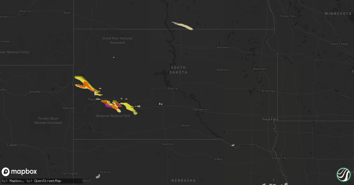
Hail Map in South Dakota on June 19, 2021
Get this storm
June 19 map
$229
one time, instant access
Download today. No call, no setup
Keep the $229
Bought the map and want the full workflow? Apply the entire $229 to a subscription within 7 days. None of it is wasted.
Every map, not just this one
This buys you this map. Subscription and you get every map we run, in the markets you choose from a few cities to whole states to nationwide. Plus real-time alerts the moment a storm fires.
Contact data
Name, contact info, occupancy, even credit band for addresses in the footprint. You go from where it hit to who to call.
Become the source they trust
Unlimited branding weather history reports on demand. You already have the documented answer ready for the property owner, and you are the one who showed up with it.
Property data and RoofTrace estimates
Pull up any address you have got, its value and the exact code rules for that jurisdiction, straight from One Click Code. Then RoofTrace estimates the squares, pitch, and roof value, priced the way you price.
Storm reports in South Dakota
South Dakota
| Date | Description |
|---|---|
| 06/19/20216:55 PM CDT | Mostly nickels covered the ground |
| 06/19/20216:45 PM CDT | A local report indicates 60 MPH wind near DEADWOOD |
| 06/19/20216:40 PM CDT | A local report indicates 1.75 inch wind near 3 ENE WHITEWOOD |
| 06/19/20216:35 PM CDT | A local report indicates 1.75 inch wind near WHITEWOOD |
| 06/19/20216:00 PM CDT | A local report indicates 1.00 inch wind near BELLE FOURCHE |
| 06/19/20215:50 PM CDT | A local report indicates 1.00 inch wind near 1 SSE BELLE FOURCHE |
| 06/19/20213:06 AM CDT | At 806 PM MDT, a severe thunderstorm was located 4 miles northwest of Delta 1 Launch Facility, or 19 miles southwest of Philip, moving east at 25 mph. HAZARD...60 mph wind gusts and half dollar size hail. SOURCE...Radar indicated. IMPACT...Hail damage to vehicles is expected. Expect wind damage to roofs, siding, and trees. This severe thunderstorm will be near... Cottonwood and Delta 1 Launch Facility around 815 PM MDT. Cactus Flat and Minuteman Missile Visitors Center around 825 PM MDT.Other locations in the path of this severe thunderstorm includeKadoka.This includes Interstate 90 in South Dakota between Mile Markers 113and 152. |
| 06/19/20212:48 AM CDT | At 748 PM MDT, a severe thunderstorm was located 5 miles east of Farmingdale, or 23 miles east of Rapid City, moving southeast at 30 mph. HAZARD...Golf ball size hail and 60 mph wind gusts. SOURCE...Radar indicated. IMPACT...People and animals outdoors will be injured. Expect hail damage to roofs, siding, windows, and vehicles. Expect wind damage to roofs, siding, and trees. This severe thunderstorm will be near... Owanka around 805 PM MDT.Other locations in the path of this severe thunderstorm includeScenic, northern Badlands National Park and Pinnacles Ranger Station.This includes Interstate 90 in South Dakota between Mile Markers 103and 111. |
| 06/19/20211:57 AM CDT | At 657 PM MDT, a severe thunderstorm was located near Rapid Valley, or 4 miles northeast of Rapid City, moving east at 25 mph. HAZARD...60 mph wind gusts and quarter size hail. SOURCE...Radar indicated. IMPACT...Hail damage to vehicles is expected. Expect wind damage to roofs, siding, and trees. This severe thunderstorm will be near... Rapid Valley and southern Ellsworth Air Force Base around 700 PM MDT. Box Elder around 705 PM MDT. Rapid City Airport around 710 PM MDT.Other locations in the path of this severe thunderstorm include NewUnderwood.This includes Interstate 90 in South Dakota between Mile Markers 59and 85. |
| 06/19/20211:10 AM CDT | At 610 PM MDT, a severe thunderstorm was located 6 miles northeast of Tilford, or 10 miles southeast of Sturgis, moving east at 35 mph. HAZARD...60 mph wind gusts and half dollar size hail. SOURCE...Radar indicated. IMPACT...Hail damage to vehicles is expected. Expect wind damage to roofs, siding, and trees. Locations impacted include... Hereford, Viewfield and Curlew Lake.This includes Interstate 90 in South Dakota between Mile Markers 38and 41. |
| 06/19/202112:53 AM CDT | At 553 PM MDT, a severe thunderstorm was located 8 miles northwest of Ellsworth Air Force Base, or 13 miles north of Rapid City, moving east at 25 mph. HAZARD...Golf ball size hail and 60 mph wind gusts. SOURCE...Radar indicated. IMPACT...People and animals outdoors will be injured. Expect hail damage to roofs, siding, windows, and vehicles. Expect wind damage to roofs, siding, and trees. This severe thunderstorm will be near... Ellsworth Air Force Base around 600 PM MDT.Other locations in the path of this severe thunderstorm includeViewfield and Curlew Lake.This includes Interstate 90 in South Dakota between Mile Markers 73and 74, and between Mile Markers 76 and 82. |
| 06/19/202112:35 AM CDT | At 534 PM MDT, a severe thunderstorm was located 5 miles northeast of Whitewood, or 7 miles north of Sturgis, moving southeast at 25 mph. HAZARD...Quarter size hail. SOURCE...Radar indicated. IMPACT...Damage to vehicles is expected. This severe thunderstorm will be near... Bear Butte State Park around 550 PM MDT.This includes Interstate 90 in South Dakota between Mile Markers 21and 24. |
| 06/19/202112:11 AM CDT | At 511 PM MDT, a severe thunderstorm was located near Crow Peak, or 3 miles southwest of Spearfish, moving east at 35 mph. HAZARD...60 mph wind gusts and quarter size hail. SOURCE...Radar indicated. IMPACT...Hail damage to vehicles is expected. Expect wind damage to roofs, siding, and trees. This severe thunderstorm will be near... Bridal Veil Falls around 515 PM MDT. Spearfish and northern Spearfish Canyon around 520 PM MDT. Lead, Deadwood and Central City around 530 PM MDT.Other locations in the path of this severe thunderstorm includeWhitewood, Galena, Apple Springs, Sturgis, Fort Meade and Tilford.This includes Interstate 90 in South Dakota near Mile Marker 7,between Mile Markers 11 and 19, near Mile Marker 22, and between MileMarkers 24 and 46. |
| 06/18/202111:42 PM CDT | At 442 PM MDT, a severe thunderstorm was located over Belle Fourche, moving east at 30 mph. HAZARD...60 mph wind gusts and quarter size hail. SOURCE...Radar indicated. IMPACT...Hail damage to vehicles is expected. Expect wind damage to roofs, siding, and trees. This severe thunderstorm will be near... Belle Fourche Reservoir around 450 PM MDT. Fruitdale around 500 PM MDT.Other locations in the path of this severe thunderstorm include SaintOnge, Nisland, Vale and Bear Butte State Park. |
| 06/18/20219:22 PM CDT | A local report indicates 60 MPH wind near 1 S CACTUS FLAT |
| 06/18/20219:22 PM CDT | Mostly dime size hail with a few quarter size |
| 06/18/20219:22 PM CDT | Lots of nickel-sized hail |
| 06/18/20218:50 PM CDT | A local report indicates 2.00 inch wind near 9 SW WALL |
| 06/18/20218:08 PM CDT | A local report indicates 58 MPH wind near RAPID CITY ARPT |
| 06/18/20217:00 PM CDT | A local report indicates 1.00 inch wind near 1 S STURGIS |
All States Impacted by Hail Map on June 19, 2021
Cities Impacted by Hail Map on June 19, 2021
- Sherman, ME
- Akron, CO
- Center, MO
- Pueblo, CO
- Harrisburg, NE
- Oakley, KS
- Norton, KS
- Lenora, KS
- Saint David, ME
- Madawaska, ME
- Grand Isle, ME
- Frenchville, ME
- Saint Agatha, ME
- Whitewood, SD
- Pearl, IL
- Pittsfield, IL
- Farmersville, IL
- Calhan, CO
- Peyton, CO
- Kimball, NE
- Frankford, MO
- Canaan, ME
- Pittsfield, ME
- Elkhart, IN
- Goshen, IN
- Chillicothe, MO
- Hale, MO
- Paris, MO
- Madison, MO
- Eads, CO
- Skowhegan, ME
- Caputa, SD
- New Underwood, SD
- Troy, MO
- Las Animas, CO
- Sturgis, SD
- La Plata, MO
- Old Monroe, MO
- Moscow Mills, MO
- Hudson, MI
- Pittsford, MI
- Morenci, MI
- Osseo, MI
- Waldron, MI
- Quinn, SD
- Jerome, MI
- Allen, MI
- Quincy, MI
- Reading, MI
- Jonesville, MI
- Hillsdale, MI
- Coldwater, MI
- North Adams, MI
- Stoutsville, MO
- Perry, MO
- Ethel, MO
- Saint Francis, KS
- Deer Isle, ME
- Knox, IN
- La Porte, IN
- Union Mills, IN
- Kingsford Heights, IN
- Hanna, IN
- Hamlet, IN
- Sterling, CO
- Atwood, CO
- Atlanta, MO
- Gibbs, MO
- Hurdland, MO
- Bethel, MO
- Shelbyville, MO
- Clayton, MI
- Camden, MI
- Saint Louis, MO
- Chesterfield, MO
- Montgomery, MI
- Annada, MO
- Elsberry, MO
- Pleasant Hill, IL
- Nebo, IL
- Logan, IA
- Magnolia, IA
- Bowling Green, MO
- Louisiana, MO
- Fort Morgan, CO
- Ramah, CO
- Caribou, ME
- Mendon, MO
- Sunset, ME
- Searsmont, ME
- Islesboro, ME
- Union, ME
- Liberty, ME
- Lincolnville, ME
- Hope, ME
- Milo, ME
- Sundance, WY
- Wall, SD
- Wasta, SD
- Scenic, SD
- Merino, CO
- Snyder, CO
- Brownstown, IL
- Rapid City, SD
- Piedmont, SD
- Limon, CO
- Almena, KS
- Millersburg, IN
- McClave, CO
- Saint Onge, SD
- Deadwood, SD
- Lead, SD
- Belle Fourche, SD
- Fort Meade, SD
- Box Elder, SD
- Spearfish, SD
- Perham, ME
- New Raymer, CO
- Wright City, MO
- Flagler, CO
- Arriba, CO
- Dodge, NE
- Scribner, NE
- Holly, CO
- Ashley, ND
- Zeeland, ND
- Strasburg, ND
- Eureka, SD
- Hague, ND
- Pawnee, IL
- Saint Francis, WI
- Cudahy, WI
- Elbert, CO
- Kiel, WI
- Newton, WI
- Sheboygan, WI
- Cleveland, WI
- Dawson, IL
- Riverton, IL
- Springfield, IL
- Interior, SD
- Kadoka, SD
- Dix, NE
- Harvel, IL
- Maryville, MO
- Conception Junction, MO
- Barnard, MO
- Payson, IL
- Hamburg, IL
- Batchtown, IL
- Golden Eagle, IL
- O'Fallon, MO
- Saint Charles, MO
- Emden, MO
- Philadelphia, MO
- Monroe City, MO
- Palmyra, MO
- Ashland, MO
- Columbia, MO
- Franklin, IL
- Waverly, IL
- Rocheport, MO
- Jacksonville, IL
- Fremont, IN
- Hannibal, MO
- Cassopolis, MI
- Curryville, MO
- Manitowoc, WI
- Brunswick, MO
- Bridgeport, NE
- Potter, NE
- Fenton, MO
- High Ridge, MO
- Higbee, MO
- Rockbridge, IL
- Carrollton, IL
- Sangerville, ME
- Guilford, ME
- Newark, MO
- Greenfield, IL
- Eldred, IL
- Triplett, MO
- Sumner, MO
- Chamois, MO
- Morrisonville, IL
- Selden, KS
- Breckenridge, MO
- Middletown, MO
- Auxvasse, MO
- Kingdom City, MO
- Levant, KS
- Eolia, MO
- Padroni, CO
- San Pierre, IN
- Franksville, WI
- Muskego, WI
- Waterford, WI
- Big Bend, WI
- Valley Park, MO
- Ballwin, MO
- Eureka, MO
- Imperial, MO
- Arnold, MO
- New Buffalo, MI
- Roodhouse, IL
- New London, MO
- Imogene, IA
- Moberly, MO
- Wanblee, SD
- Phillipsburg, KS
- Anton, CO
- Silex, MO
- Omaha, NE
- Shelbyville, IL
- Findlay, IL
- Bonnots Mill, MO
- Tebbetts, MO
- New Bloomfield, MO
- Jonesburg, MO
- Warrenton, MO
- Truxton, MO
- Hawk Point, MO
- Bellflower, MO
- Columbus, NE
- Humphrey, NE
- Creston, NE
- Lamar, CO
- Sidney, NE
- Long Island, KS
- Baxley, GA
- Broadwater, NE
- Oakland, NE
- West Point, NE
- Hooper, NE
- Uehling, NE
- Prairie View, KS
- La Junta, CO
- Burr Oak, KS
- Guide Rock, NE
- Red Cloud, NE
- New Sweden, ME
- Clarksville, MO
- Dalton, NE
- Gurley, NE
- Braymer, MO
- Foristell, MO
- Hardin, IL
- Foley, MO
- Brussels, IL
- Lake Saint Louis, MO
- Wentzville, MO
- Shelbina, MO
- Saint Peters, MO
- Grafton, IL
- Maywood, MO
- Winfield, MO
- Hunnewell, MO
- Portage Des Sioux, MO
- Bridgeton, MO
- Laddonia, MO
- Maryland Heights, MO
- Farber, MO
- Fieldon, IL
- Ewing, MO
- Vandalia, MO
- Earth City, MO
- Rockport, IL
- Petersburg, OH
- New Springfield, OH
- North Lima, OH
- Youngstown, OH
- Middlebury, IN
- Leola, SD
- Rothville, MO
- Keytesville, MO
- Meadville, MO
- Marceline, MO
- Dawn, MO
- Wheeling, MO
- Agate, CO
- Colorado Springs, CO
- Woodrow, CO
- Bristol, IN
- Sturgeon, MO
- Hallsville, MO
- Thompson, MO
- Centralia, MO
- Fulton, MO
- Mexico, MO
- Winchester, IL
- Virden, IL
- Modesto, IL
- Woodson, IL
- Murrayville, IL
- Tekamah, NE
- Sterling, NE
- Brush, CO
- Hillrose, CO
- Vona, CO
- Reedsville, WI
- Riverton, NE
- Mercer, PA
- Hermitage, PA
- Colby, KS
- Edwardsburg, MI
- Dowagiac, MI
- Niles, MI
- Syracuse, KS
- Coolidge, KS
- Two Rivers, WI
- Brooklin, ME
- Inavale, NE
- Naponee, NE
- Franklin, NE
- Bloomington, NE
- Meadow, SD
- Howells, NE
- Macon, MO
- Adrian, MI
- Cope, CO
- Clark, MO
- Watson, MO
- Peru, NE
- Seibert, CO
- Loraine, IL
- Carpenter, WY
- Burns, WY
- Deer Trail, CO
- Hasty, CO
- Michigan City, IN
- Union Pier, MI
- Three Oaks, MI
- Genoa, CO
- Lindon, CO
- Glasgow, MO
- Burr, NE
- Union Grove, WI
- Caledonia, WI
- Sturtevant, WI
- Mukwonago, WI
- Salisbury, MO
- Graham, MO
- Hettick, IL
- Chesterfield, IL
- Carlinville, IL
- Fort Yates, ND
- New Cambria, MO
- Huntsville, MO
- Mondamin, IA
- Truesdale, MO
- Osceola, IN
- Granger, IN
- Mechanicsburg, IL
- Albion, NE
- Paloma, IL
- Camp Point, IL
- Mendon, IL
- Golden, IL
- Mount Sterling, IL
- Coatsburg, IL
- Clayton, IL
- Timewell, IL
- Rexford, KS
- Jennings, KS
- Brewster, KS
- Gem, KS
- Dresden, KS
- Concordia, MO
- Chula, MO
- Okaton, SD
- Gilliam, MO
- Robinson, IL
- Barnhart, MO
- Wildwood, MO
- Fort Fairfield, ME
- Presque Isle, ME
- Easton, ME
- Alliance, NE
- Angora, NE
- Hugo, CO
- Clifton Hill, MO
- Avon, SD
- Springfield, SD
- Niobrara, NE
- La Crosse, IN
- Brillion, WI
- Creston, IA
- Oakland, ME
- Belgrade, ME
- North Judson, IN
- Kouts, IN
- Medaryville, IN
- Wheatfield, IN
- Brookfield, MO
- Tina, MO
- Ravenwood, MO
- Woodbine, IA
- Mankato, KS
- Bird City, KS
- Washburn, ME
- Wilsonville, NE
- Hendley, NE
- Bayard, NE
- Kampsville, IL
- Ludlow, MO
- Beaver City, NE
- Larkspur, CO
- Stockholm, ME
- Portland, MO
- Linton, ND
- Oberlin, KS
- Belgrade Lakes, ME
- Shipshewana, IN
- Skidmore, MO
- Bolckow, MO
- Armstrong, MO
- Fayette, MO
- Peetz, CO
- Long Lake, SD
- Hoxie, KS
- Chapin, IL
- Montague, MI
- Fort Lupton, CO
- Greenleaf, WI
- Eau Claire, MI
- Berrien Center, MI
- Union, MI
- Murdo, SD
- New Era, MI
- Quaker City, OH
- Palermo, ME
- Volant, PA
- Wooldridge, MO
- Owanka, SD
- Agenda, KS
- Grainfield, KS
- Vernon, CO
- Tobias, NE
- Simpson, KS
- Milligan, NE
- Mahaska, KS
- Downs, KS
- Matheson, CO
- Funk, NE
- Fairbury, NE
- Beloit, KS
- Bertrand, NE
- Wray, CO
- Lawrence, NE
- Republic, KS
- Trenton, NE
- Western, NE
- Stratton, CO
- Kensington, KS
- Quinter, KS
- Wauneta, NE
- Joes, CO
- Wilcox, NE
- Hays, KS
- Damar, KS
- Juniata, NE
- Deshler, NE
- Formoso, KS
- Stockville, NE
- Lebanon, NE
- Exeter, NE
- Scandia, KS
- Ellis, KS
- Cheyenne Wells, CO
- Penokee, KS
- Hunter, KS
- Plainville, KS
- Geneva, NE
- Saronville, NE
- Park, KS
- Delphos, KS
- Bartley, NE
- Dorrance, KS
- Bethune, CO
- Catharine, KS
- Goodland, KS
- Karval, CO
- McDonald, KS
- Idalia, CO
- Morrowville, KS
- Eustis, NE
- Gilead, NE
- Culbertson, NE
- Paoli, CO
- Maywood, NE
- Wakeeney, KS
- Herndon, KS
- Sylvan Grove, KS
- Imperial, NE
- Champion, NE
- De Witt, NE
- Parks, NE
- Ohiowa, NE
- Strang, NE
- Tipton, KS
- Stockton, KS
- Wallace, KS
- Natoma, KS
- Kit Carson, CO
- Courtland, KS
- Lucas, KS
- Belvidere, NE
- Gorham, KS
- Danbury, NE
- Fairmont, NE
- Holbrook, NE
- Ludell, KS
- Heartwell, NE
- Smith Center, KS
- Axtell, NE
- Bladen, NE
- Cuba, KS
- Munden, KS
- Osborne, KS
- Lebanon, KS
- Barnard, KS
- Julesburg, CO
- Holdrege, NE
- Jewell, KS
- Woodston, KS
- Harvard, NE
- Bunker Hill, KS
- Fairfield, NE
- Gove, KS
- Agra, KS
- Cedar, KS
- Oak, NE
- Glasco, KS
- Haigler, NE
- Paradise, KS
- Kirk, CO
- Jamestown, KS
- Blue Hill, NE
- Holyoke, CO
- Waldo, KS
- Collyer, KS
- Daykin, NE
- Moorefield, NE
- Yuma, CO
- Portis, KS
- Walker, KS
- Athol, KS
- Hastings, NE
- Campbell, NE
- Belleville, KS
- Venango, NE
- Davenport, NE
- Palco, KS
- Cambridge, NE
- Clayton, KS
- Edson, KS
- Hill City, KS
- Narka, KS
- Inland, NE
- Kanorado, KS
- Curtis, NE
- Swanton, NE
- Oxford, NE
- Reynolds, NE
- Holstein, NE
- Gaylord, KS
- Roseland, NE
- Plymouth, NE
- Burlington, CO
- Haxtun, CO
- Wild Horse, CO
- Indianola, NE
- Bogue, KS
- Hardy, NE
- Luray, KS
- Republican City, NE
- Clay Center, NE
- Superior, NE
- Bruning, NE
- Deweese, NE
- Esbon, KS
- Grafton, NE
- Arapahoe, NE
- Wilson, KS
- Winona, KS
- Ong, NE
- Shickley, NE
- Norway, KS
- Enders, NE
- Elwood, NE
- Randall, KS
- Wilber, NE
- Ogallah, KS
- Max, NE
- Edgar, NE
- Glade, KS
- Hebron, NE
- Hubbell, NE
- Orleans, NE
- Morland, KS
- Byron, NE
- Stratton, NE
- Hildreth, NE
- Grinnell, KS
- Concordia, KS
- Eckley, CO
- Monument, KS
- Sharon Springs, KS
- Alton, KS
- Minden, NE
- Norcatur, KS
- Ruskin, NE
- Glenvil, NE
- Ayr, NE
- Arapahoe, CO
- Chester, NE
- Lincoln, KS
- Benkelman, NE
- Atwood, KS
- Stamford, NE
- Atlanta, NE
- Nelson, NE
- Amherst, CO
- Glen Elder, KS
- Weskan, KS
- Otis, CO
- Logan, KS
- Carleton, NE
- Alexandria, NE
- Edison, NE
- Jansen, NE
- McCook, NE
- Sutton, NE
- Endicott, NE
- Russell, KS
- Loomis, NE
- Cawker City, KS
- Alma, NE
- Victoria, KS
- Upland, NE
- Kirwin, KS
- Webber, KS
- Granada, CO
- Two Buttes, CO
- Springfield, CO
- Kim, CO
- Walsh, CO
- Pritchett, CO
- Wiley, CO
- Manter, KS
- Mount Auburn, IL
- Buffalo, IL
- Rochester, IL
- Edinburg, IL
- Pleasant Plains, IL
- Tallula, IL
- Cantrall, IL
- Stonington, IL
- Blue Mound, IL
- Pacific, MO
- House Springs, MO
- Camden, ME
- Morrill, ME
- Wayne, ME
- Winthrop, ME
- Readfield, ME
- Grand Bay, AL
- Pensacola, FL
- Lillian, AL
- Elberta, AL
- Orange Beach, AL
- Gulf Breeze, FL
- Milton, FL
- Evergreen, AL
- Castleberry, AL
- Brewton, AL
- Gulf Shores, AL
- Jakin, GA
- Pansey, AL
- Greenwood, FL
- Bascom, FL
- Malone, FL
- Blakely, GA
- Gordon, AL
- Bluffton, GA
- Coleman, GA
- Fort Gaines, GA
- Florala, AL
- Opp, AL
- Andalusia, AL
- Laurel Hill, FL
- Baker, FL
- Defuniak Springs, FL
- Westville, FL
- Samson, AL
- Bonifay, FL
- Caryville, FL
- Graceville, FL
- Vernon, FL
- Ponce De Leon, FL
- Geneva, AL
- Louisville, AL
- Clayton, AL
- Washington, ME


