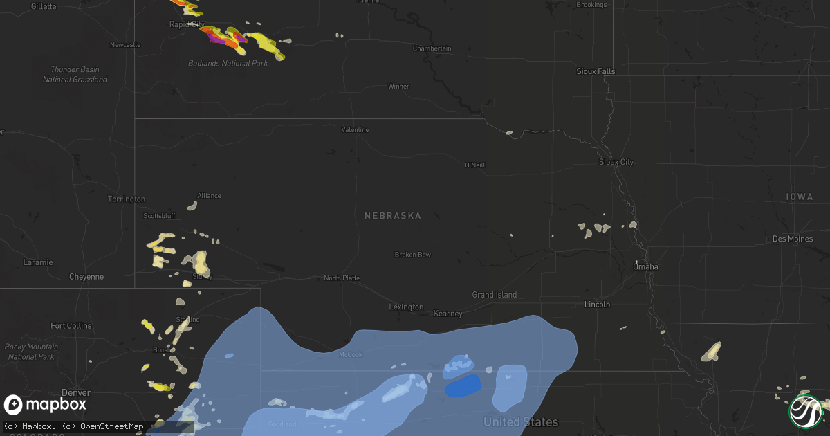
Hail Map in Nebraska on June 19, 2021
Get this storm
June 19 map
$229
one time, instant access
Download today. No call, no setup
Keep the $229
Bought the map and want the full workflow? Apply the entire $229 to a subscription within 7 days. None of it is wasted.
Every map, not just this one
This buys you this map. Subscription and you get every map we run, in the markets you choose from a few cities to whole states to nationwide. Plus real-time alerts the moment a storm fires.
Contact data
Name, contact info, occupancy, even credit band for addresses in the footprint. You go from where it hit to who to call.
Become the source they trust
Unlimited branding weather history reports on demand. You already have the documented answer ready for the property owner, and you are the one who showed up with it.
Property data and RoofTrace estimates
Pull up any address you have got, its value and the exact code rules for that jurisdiction, straight from One Click Code. Then RoofTrace estimates the squares, pitch, and roof value, priced the way you price.
Storm reports in Nebraska
Nebraska
| Date | Description |
|---|---|
| 06/19/20212:55 PM CDT | Storm chasers reported a small landspout tornado along county road 6 near nebraska highway 71. Landspout lasted for about 5 minutes before lifting. |
| 06/19/20215:45 AM CDT | At 1044 PM CDT, severe thunderstorms were located along a line extending from near Wilcox to near Campbell to 6 miles northeast of Inavale to 6 miles south of Red Cloud to 9 miles west of Ionia, moving northeast at 55 mph. These are very dangerous storms. HAZARD...80 mph wind gusts. SOURCE...Law enforcement. Law enforcement reported widespread damage across Phillips County. Additionsly at 10:35pm 83 MPH was reported at Smith Center, Kansas Airport. IMPACT...Flying debris will be dangerous to those caught without shelter. Mobile homes will be heavily damaged. Expect considerable damage to roofs, windows, and vehicles. Extensive tree damage and power outages are likely. Severe thunderstorms will be near... Red Cloud and Cowles around 1050 PM CDT. Bladen, Guide Rock and Esbon around 1055 PM CDT. Blue Hill, Upland and Rosemont around 1100 PM CDT.Other locations in the path of these severe thunderstorms includeMankato, Lawrence, Burr Oak, Ayr, Bostwick, Norman, Montrose, Nelson,Holstein, Formoso, Heartwell, Deweese, Fairfield, Glenvil, Roseland,Webber, Nora, Lovewell State Park, Kenesaw, Edgar, Inland and Oak. |
| 06/19/20214:09 AM CDT | At 908 PM CDT, severe thunderstorms were located along a line extending from 13 miles east of Hayes Center to near Indianola, moving northeast at 35 mph. HAZARD...60 mph wind gusts. SOURCE...Radar indicated. IMPACT...Expect damage to roofs, siding, and trees. Locations impacted include... Curtis, Moorefield, Stockville, Medicine Creek Reservoir State Recreation Area, Quick, Orafino, Bluegill Haven Campground, Willow View Campground, Freedom, Red Willow Reservoir State Recreation Area and Dancing Leaf Earth Lodge.This includes Highway 83 between mile markers 27 and 45. |
| 06/19/20213:54 AM CDT | At 853 PM CDT, severe thunderstorms were located along a line extending from 7 miles northeast of Culbertson to 8 miles north of Oberlin to 3 miles northeast of Selden, moving east at 35 mph. HAZARD...60 mph wind gusts. SOURCE...Radar indicated. IMPACT...Expect damage to roofs, siding, and trees. Severe thunderstorms will be near... McCook, Danbury and Dresden around 905 PM CDT.Other locations in the path of these severe thunderstorms includeJennings, Lebanon, Indianola, Bartley, Lenora, Edmond and Almena. |
| 06/19/20212:30 AM CDT | 1-inch tree limbs broken; shingles blown off. |
| 06/19/20212:29 AM CDT | At 729 PM CDT, severe thunderstorms were located along a line extending from near Wauneta to 14 miles south of St. Francis, moving east at 45 mph. These are very dangerous storms. HAZARD...80 mph wind gusts. SOURCE...Public. IMPACT...Flying debris will be dangerous to those caught without shelter. Mobile homes will be heavily damaged. Expect considerable damage to roofs, windows, and vehicles. Extensive tree damage and power outages are likely. Locations impacted include... Palisade and Dresden. |
| 06/19/20211:12 AM CDT | 6-7 inch branch down from old tree. |
| 06/19/202112:47 AM CDT | 1 ft diameter tree branch blown down. |
| 06/19/202112:24 AM CDT | At 522 PM MDT, severe thunderstorms were located along a line extending from 8 miles north of Venango to 13 miles south of Pleasant Valley, moving southeast at 35 mph. HAZARD...60 mph wind gusts. SOURCE...Radar indicated. IMPACT...Expect damage to roofs, siding, and trees. Locations impacted include... Imperial, Grant, Madrid, Venango, Elsie, Lamar, Enders, Enders Reservoir State Recreation Area, Champion, Crete, Chase, Center Dam Campground, Brandon, Wild Horse Spring, Wanamaker State Wildfire Management Area, Area A Campground and Church Grove Campground.This includes Highway 61 between mile markers 25 and 77. |
| 06/19/202112:16 AM CDT | At 516 PM MDT, severe thunderstorms were located along a line extending from 9 miles northwest of Venango to 13 miles north of Eckley, or along a line extending from 10 miles southeast of Julesburg to 18 miles northeast of Yuma, moving east at 20 mph. HAZARD...60 mph wind gusts and penny size hail. SOURCE...Radar indicated. IMPACT...Expect damage to roofs, siding, and trees. Locations impacted include... Holyoke, Amherst, Pleasant Valley and Sixteen-Mile Corner. |
| 06/19/202112:02 AM CDT | At 502 PM MDT, severe thunderstorms were located along a line extending from 3 miles northwest of Highland Center to 5 miles south of Yuma to 5 miles south of Cope, moving east at 35 mph. HAZARD...60 mph wind gusts and quarter size hail. SOURCE...Radar indicated. IMPACT...Hail damage to vehicles is expected. Expect wind damage to roofs, siding, and trees. Severe thunderstorms will be near... Eckley around 520 PM MDT.Other locations in the path of these severe thunderstorms includeWray.This includes Highway 385 between mile markers 207 and 210, andbetween mile markers 212 and 270. |
| 06/18/202111:45 PM CDT | 50 to 60 mph wind gusts reported near road t and road 311. |
| 06/18/202111:40 PM CDT | Corrects previous tstm wnd gst report from 6 ese clay center. 50 to 60 mph wind gusts reported near road t and road 311. |
| 06/18/202111:00 PM CDT | Roof ripped off motor home... Tree branches down as well. |
| 06/18/202110:25 PM CDT | Multiple trees down in franklin... Multiple power lines down across the county and several transformers out. |
| 06/18/20219:46 PM CDT | At 245 PM MDT, a severe thunderstorm was located near Angora, or 15 miles southwest of Alliance, moving east at 20 mph. HAZARD...60 mph wind gusts and half dollar size hail. SOURCE...Radar indicated. IMPACT...Hail damage to vehicles is expected. Expect wind damage to roofs, siding, and trees. Locations impacted include... Alliance and Alliance Airport. |
| 06/18/20219:42 PM CDT | At 241 PM MDT, severe thunderstorms were located along a line extending from 13 miles southwest of Redington to near Kimball, moving east at 15 mph. HAZARD...60 mph wind gusts and quarter size hail. SOURCE...Radar indicated. IMPACT...Hail damage to vehicles is expected. Expect wind damage to roofs, siding, and trees. Locations impacted include... Kimball, Dix and Kimball Airport. This includes Interstate 80 in Nebraska between mile markers 14 and34. |
| 06/18/20219:04 PM CDT | At 203 PM MDT, severe thunderstorms were located along a line extending from 7 miles west of Chimney Rock State Park to 6 miles east of Harrisburg to 13 miles east of Albin, moving east at 25 mph. HAZARD...60 mph wind gusts and quarter size hail. SOURCE...Radar indicated. IMPACT...Hail damage to vehicles is expected. Expect wind damage to roofs, siding, and trees. Locations impacted include... Bridgeport, Northport, Chimney Rock State Park, Bridgeport State Recreation Area, Redington, South Bayard Junction and Harrisburg. |
| 06/18/20219:02 PM CDT | Asos station kmck mccook airport reported a peak wind gust of 59 knots |
| 06/18/20218:59 PM CDT | Asos station kmck mccook airport. |
| 06/18/20218:55 PM CDT | Corrects previous tstm wnd gst report from 2 e mccook. 58 knot |
| 06/18/20218:54 PM CDT | Site knemccoo24. |
| 06/18/20217:30 PM CDT | Power lines down in benkelman. Report received at 2z. Time estimated by radar. |
| 06/18/20217:26 PM CDT | Caller reported a couple 8 to 10 inch tree limbs down. |
| 06/18/20217:24 PM CDT | Site knebenke3 reported multiple 63 mph gusts. |
| 06/18/20217:07 PM CDT | Power out as well. |
| 06/18/20217:00 PM CDT | Estimated wind gusts of 60-70 mph; lost power briefly. |
All States Impacted by Hail Map on June 19, 2021
Cities Impacted by Hail Map on June 19, 2021
- Sherman, ME
- Akron, CO
- Center, MO
- Pueblo, CO
- Harrisburg, NE
- Oakley, KS
- Norton, KS
- Lenora, KS
- Saint David, ME
- Madawaska, ME
- Grand Isle, ME
- Frenchville, ME
- Saint Agatha, ME
- Whitewood, SD
- Pearl, IL
- Pittsfield, IL
- Farmersville, IL
- Calhan, CO
- Peyton, CO
- Kimball, NE
- Frankford, MO
- Canaan, ME
- Pittsfield, ME
- Elkhart, IN
- Goshen, IN
- Chillicothe, MO
- Hale, MO
- Paris, MO
- Madison, MO
- Eads, CO
- Skowhegan, ME
- Caputa, SD
- New Underwood, SD
- Troy, MO
- Las Animas, CO
- Sturgis, SD
- La Plata, MO
- Old Monroe, MO
- Moscow Mills, MO
- Hudson, MI
- Pittsford, MI
- Morenci, MI
- Osseo, MI
- Waldron, MI
- Quinn, SD
- Jerome, MI
- Allen, MI
- Quincy, MI
- Reading, MI
- Jonesville, MI
- Hillsdale, MI
- Coldwater, MI
- North Adams, MI
- Stoutsville, MO
- Perry, MO
- Ethel, MO
- Saint Francis, KS
- Deer Isle, ME
- Knox, IN
- La Porte, IN
- Union Mills, IN
- Kingsford Heights, IN
- Hanna, IN
- Hamlet, IN
- Sterling, CO
- Atwood, CO
- Atlanta, MO
- Gibbs, MO
- Hurdland, MO
- Bethel, MO
- Shelbyville, MO
- Clayton, MI
- Camden, MI
- Saint Louis, MO
- Chesterfield, MO
- Montgomery, MI
- Annada, MO
- Elsberry, MO
- Pleasant Hill, IL
- Nebo, IL
- Logan, IA
- Magnolia, IA
- Bowling Green, MO
- Louisiana, MO
- Fort Morgan, CO
- Ramah, CO
- Caribou, ME
- Mendon, MO
- Sunset, ME
- Searsmont, ME
- Islesboro, ME
- Union, ME
- Liberty, ME
- Lincolnville, ME
- Hope, ME
- Milo, ME
- Sundance, WY
- Wall, SD
- Wasta, SD
- Scenic, SD
- Merino, CO
- Snyder, CO
- Brownstown, IL
- Rapid City, SD
- Piedmont, SD
- Limon, CO
- Almena, KS
- Millersburg, IN
- McClave, CO
- Saint Onge, SD
- Deadwood, SD
- Lead, SD
- Belle Fourche, SD
- Fort Meade, SD
- Box Elder, SD
- Spearfish, SD
- Perham, ME
- New Raymer, CO
- Wright City, MO
- Flagler, CO
- Arriba, CO
- Dodge, NE
- Scribner, NE
- Holly, CO
- Ashley, ND
- Zeeland, ND
- Strasburg, ND
- Eureka, SD
- Hague, ND
- Pawnee, IL
- Saint Francis, WI
- Cudahy, WI
- Elbert, CO
- Kiel, WI
- Newton, WI
- Sheboygan, WI
- Cleveland, WI
- Dawson, IL
- Riverton, IL
- Springfield, IL
- Interior, SD
- Kadoka, SD
- Dix, NE
- Harvel, IL
- Maryville, MO
- Conception Junction, MO
- Barnard, MO
- Payson, IL
- Hamburg, IL
- Batchtown, IL
- Golden Eagle, IL
- O'Fallon, MO
- Saint Charles, MO
- Emden, MO
- Philadelphia, MO
- Monroe City, MO
- Palmyra, MO
- Ashland, MO
- Columbia, MO
- Franklin, IL
- Waverly, IL
- Rocheport, MO
- Jacksonville, IL
- Fremont, IN
- Hannibal, MO
- Cassopolis, MI
- Curryville, MO
- Manitowoc, WI
- Brunswick, MO
- Bridgeport, NE
- Potter, NE
- Fenton, MO
- High Ridge, MO
- Higbee, MO
- Rockbridge, IL
- Carrollton, IL
- Sangerville, ME
- Guilford, ME
- Newark, MO
- Greenfield, IL
- Eldred, IL
- Triplett, MO
- Sumner, MO
- Chamois, MO
- Morrisonville, IL
- Selden, KS
- Breckenridge, MO
- Middletown, MO
- Auxvasse, MO
- Kingdom City, MO
- Levant, KS
- Eolia, MO
- Padroni, CO
- San Pierre, IN
- Franksville, WI
- Muskego, WI
- Waterford, WI
- Big Bend, WI
- Valley Park, MO
- Ballwin, MO
- Eureka, MO
- Imperial, MO
- Arnold, MO
- New Buffalo, MI
- Roodhouse, IL
- New London, MO
- Imogene, IA
- Moberly, MO
- Wanblee, SD
- Phillipsburg, KS
- Anton, CO
- Silex, MO
- Omaha, NE
- Shelbyville, IL
- Findlay, IL
- Bonnots Mill, MO
- Tebbetts, MO
- New Bloomfield, MO
- Jonesburg, MO
- Warrenton, MO
- Truxton, MO
- Hawk Point, MO
- Bellflower, MO
- Columbus, NE
- Humphrey, NE
- Creston, NE
- Lamar, CO
- Sidney, NE
- Long Island, KS
- Baxley, GA
- Broadwater, NE
- Oakland, NE
- West Point, NE
- Hooper, NE
- Uehling, NE
- Prairie View, KS
- La Junta, CO
- Burr Oak, KS
- Guide Rock, NE
- Red Cloud, NE
- New Sweden, ME
- Clarksville, MO
- Dalton, NE
- Gurley, NE
- Braymer, MO
- Foristell, MO
- Hardin, IL
- Foley, MO
- Brussels, IL
- Lake Saint Louis, MO
- Wentzville, MO
- Shelbina, MO
- Saint Peters, MO
- Grafton, IL
- Maywood, MO
- Winfield, MO
- Hunnewell, MO
- Portage Des Sioux, MO
- Bridgeton, MO
- Laddonia, MO
- Maryland Heights, MO
- Farber, MO
- Fieldon, IL
- Ewing, MO
- Vandalia, MO
- Earth City, MO
- Rockport, IL
- Petersburg, OH
- New Springfield, OH
- North Lima, OH
- Youngstown, OH
- Middlebury, IN
- Leola, SD
- Rothville, MO
- Keytesville, MO
- Meadville, MO
- Marceline, MO
- Dawn, MO
- Wheeling, MO
- Agate, CO
- Colorado Springs, CO
- Woodrow, CO
- Bristol, IN
- Sturgeon, MO
- Hallsville, MO
- Thompson, MO
- Centralia, MO
- Fulton, MO
- Mexico, MO
- Winchester, IL
- Virden, IL
- Modesto, IL
- Woodson, IL
- Murrayville, IL
- Tekamah, NE
- Sterling, NE
- Brush, CO
- Hillrose, CO
- Vona, CO
- Reedsville, WI
- Riverton, NE
- Mercer, PA
- Hermitage, PA
- Colby, KS
- Edwardsburg, MI
- Dowagiac, MI
- Niles, MI
- Syracuse, KS
- Coolidge, KS
- Two Rivers, WI
- Brooklin, ME
- Inavale, NE
- Naponee, NE
- Franklin, NE
- Bloomington, NE
- Meadow, SD
- Howells, NE
- Macon, MO
- Adrian, MI
- Cope, CO
- Clark, MO
- Watson, MO
- Peru, NE
- Seibert, CO
- Loraine, IL
- Carpenter, WY
- Burns, WY
- Deer Trail, CO
- Hasty, CO
- Michigan City, IN
- Union Pier, MI
- Three Oaks, MI
- Genoa, CO
- Lindon, CO
- Glasgow, MO
- Burr, NE
- Union Grove, WI
- Caledonia, WI
- Sturtevant, WI
- Mukwonago, WI
- Salisbury, MO
- Graham, MO
- Hettick, IL
- Chesterfield, IL
- Carlinville, IL
- Fort Yates, ND
- New Cambria, MO
- Huntsville, MO
- Mondamin, IA
- Truesdale, MO
- Osceola, IN
- Granger, IN
- Mechanicsburg, IL
- Albion, NE
- Paloma, IL
- Camp Point, IL
- Mendon, IL
- Golden, IL
- Mount Sterling, IL
- Coatsburg, IL
- Clayton, IL
- Timewell, IL
- Rexford, KS
- Jennings, KS
- Brewster, KS
- Gem, KS
- Dresden, KS
- Concordia, MO
- Chula, MO
- Okaton, SD
- Gilliam, MO
- Robinson, IL
- Barnhart, MO
- Wildwood, MO
- Fort Fairfield, ME
- Presque Isle, ME
- Easton, ME
- Alliance, NE
- Angora, NE
- Hugo, CO
- Clifton Hill, MO
- Avon, SD
- Springfield, SD
- Niobrara, NE
- La Crosse, IN
- Brillion, WI
- Creston, IA
- Oakland, ME
- Belgrade, ME
- North Judson, IN
- Kouts, IN
- Medaryville, IN
- Wheatfield, IN
- Brookfield, MO
- Tina, MO
- Ravenwood, MO
- Woodbine, IA
- Mankato, KS
- Bird City, KS
- Washburn, ME
- Wilsonville, NE
- Hendley, NE
- Bayard, NE
- Kampsville, IL
- Ludlow, MO
- Beaver City, NE
- Larkspur, CO
- Stockholm, ME
- Portland, MO
- Linton, ND
- Oberlin, KS
- Belgrade Lakes, ME
- Shipshewana, IN
- Skidmore, MO
- Bolckow, MO
- Armstrong, MO
- Fayette, MO
- Peetz, CO
- Long Lake, SD
- Hoxie, KS
- Chapin, IL
- Montague, MI
- Fort Lupton, CO
- Greenleaf, WI
- Eau Claire, MI
- Berrien Center, MI
- Union, MI
- Murdo, SD
- New Era, MI
- Quaker City, OH
- Palermo, ME
- Volant, PA
- Wooldridge, MO
- Owanka, SD
- Agenda, KS
- Grainfield, KS
- Vernon, CO
- Tobias, NE
- Simpson, KS
- Milligan, NE
- Mahaska, KS
- Downs, KS
- Matheson, CO
- Funk, NE
- Fairbury, NE
- Beloit, KS
- Bertrand, NE
- Wray, CO
- Lawrence, NE
- Republic, KS
- Trenton, NE
- Western, NE
- Stratton, CO
- Kensington, KS
- Quinter, KS
- Wauneta, NE
- Joes, CO
- Wilcox, NE
- Hays, KS
- Damar, KS
- Juniata, NE
- Deshler, NE
- Formoso, KS
- Stockville, NE
- Lebanon, NE
- Exeter, NE
- Scandia, KS
- Ellis, KS
- Cheyenne Wells, CO
- Penokee, KS
- Hunter, KS
- Plainville, KS
- Geneva, NE
- Saronville, NE
- Park, KS
- Delphos, KS
- Bartley, NE
- Dorrance, KS
- Bethune, CO
- Catharine, KS
- Goodland, KS
- Karval, CO
- McDonald, KS
- Idalia, CO
- Morrowville, KS
- Eustis, NE
- Gilead, NE
- Culbertson, NE
- Paoli, CO
- Maywood, NE
- Wakeeney, KS
- Herndon, KS
- Sylvan Grove, KS
- Imperial, NE
- Champion, NE
- De Witt, NE
- Parks, NE
- Ohiowa, NE
- Strang, NE
- Tipton, KS
- Stockton, KS
- Wallace, KS
- Natoma, KS
- Kit Carson, CO
- Courtland, KS
- Lucas, KS
- Belvidere, NE
- Gorham, KS
- Danbury, NE
- Fairmont, NE
- Holbrook, NE
- Ludell, KS
- Heartwell, NE
- Smith Center, KS
- Axtell, NE
- Bladen, NE
- Cuba, KS
- Munden, KS
- Osborne, KS
- Lebanon, KS
- Barnard, KS
- Julesburg, CO
- Holdrege, NE
- Jewell, KS
- Woodston, KS
- Harvard, NE
- Bunker Hill, KS
- Fairfield, NE
- Gove, KS
- Agra, KS
- Cedar, KS
- Oak, NE
- Glasco, KS
- Haigler, NE
- Paradise, KS
- Kirk, CO
- Jamestown, KS
- Blue Hill, NE
- Holyoke, CO
- Waldo, KS
- Collyer, KS
- Daykin, NE
- Moorefield, NE
- Yuma, CO
- Portis, KS
- Walker, KS
- Athol, KS
- Hastings, NE
- Campbell, NE
- Belleville, KS
- Venango, NE
- Davenport, NE
- Palco, KS
- Cambridge, NE
- Clayton, KS
- Edson, KS
- Hill City, KS
- Narka, KS
- Inland, NE
- Kanorado, KS
- Curtis, NE
- Swanton, NE
- Oxford, NE
- Reynolds, NE
- Holstein, NE
- Gaylord, KS
- Roseland, NE
- Plymouth, NE
- Burlington, CO
- Haxtun, CO
- Wild Horse, CO
- Indianola, NE
- Bogue, KS
- Hardy, NE
- Luray, KS
- Republican City, NE
- Clay Center, NE
- Superior, NE
- Bruning, NE
- Deweese, NE
- Esbon, KS
- Grafton, NE
- Arapahoe, NE
- Wilson, KS
- Winona, KS
- Ong, NE
- Shickley, NE
- Norway, KS
- Enders, NE
- Elwood, NE
- Randall, KS
- Wilber, NE
- Ogallah, KS
- Max, NE
- Edgar, NE
- Glade, KS
- Hebron, NE
- Hubbell, NE
- Orleans, NE
- Morland, KS
- Byron, NE
- Stratton, NE
- Hildreth, NE
- Grinnell, KS
- Concordia, KS
- Eckley, CO
- Monument, KS
- Sharon Springs, KS
- Alton, KS
- Minden, NE
- Norcatur, KS
- Ruskin, NE
- Glenvil, NE
- Ayr, NE
- Arapahoe, CO
- Chester, NE
- Lincoln, KS
- Benkelman, NE
- Atwood, KS
- Stamford, NE
- Atlanta, NE
- Nelson, NE
- Amherst, CO
- Glen Elder, KS
- Weskan, KS
- Otis, CO
- Logan, KS
- Carleton, NE
- Alexandria, NE
- Edison, NE
- Jansen, NE
- McCook, NE
- Sutton, NE
- Endicott, NE
- Russell, KS
- Loomis, NE
- Cawker City, KS
- Alma, NE
- Victoria, KS
- Upland, NE
- Kirwin, KS
- Webber, KS
- Granada, CO
- Two Buttes, CO
- Springfield, CO
- Kim, CO
- Walsh, CO
- Pritchett, CO
- Wiley, CO
- Manter, KS
- Mount Auburn, IL
- Buffalo, IL
- Rochester, IL
- Edinburg, IL
- Pleasant Plains, IL
- Tallula, IL
- Cantrall, IL
- Stonington, IL
- Blue Mound, IL
- Pacific, MO
- House Springs, MO
- Camden, ME
- Morrill, ME
- Wayne, ME
- Winthrop, ME
- Readfield, ME
- Grand Bay, AL
- Pensacola, FL
- Lillian, AL
- Elberta, AL
- Orange Beach, AL
- Gulf Breeze, FL
- Milton, FL
- Evergreen, AL
- Castleberry, AL
- Brewton, AL
- Gulf Shores, AL
- Jakin, GA
- Pansey, AL
- Greenwood, FL
- Bascom, FL
- Malone, FL
- Blakely, GA
- Gordon, AL
- Bluffton, GA
- Coleman, GA
- Fort Gaines, GA
- Florala, AL
- Opp, AL
- Andalusia, AL
- Laurel Hill, FL
- Baker, FL
- Defuniak Springs, FL
- Westville, FL
- Samson, AL
- Bonifay, FL
- Caryville, FL
- Graceville, FL
- Vernon, FL
- Ponce De Leon, FL
- Geneva, AL
- Louisville, AL
- Clayton, AL
- Washington, ME


