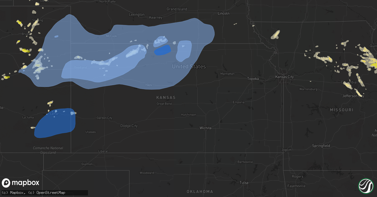
Hail Map in Kansas on June 19, 2021
Get this storm
June 19 map
$229
one time, instant access
Download today. No call, no setup
Keep the $229
Bought the map and want the full workflow? Apply the entire $229 to a subscription within 7 days. None of it is wasted.
Every map, not just this one
This buys you this map. Subscription and you get every map we run, in the markets you choose from a few cities to whole states to nationwide. Plus real-time alerts the moment a storm fires.
Contact data
Name, contact info, occupancy, even credit band for addresses in the footprint. You go from where it hit to who to call.
Become the source they trust
Unlimited branding weather history reports on demand. You already have the documented answer ready for the property owner, and you are the one who showed up with it.
Property data and RoofTrace estimates
Pull up any address you have got, its value and the exact code rules for that jurisdiction, straight from One Click Code. Then RoofTrace estimates the squares, pitch, and roof value, priced the way you price.
Storm reports in Kansas
Kansas
| Date | Description |
|---|---|
| 06/19/20216:28 AM CDT | At 1127 PM CDT, severe thunderstorms were located along a line extending from Kenesaw to near Clay Center to Edgar to Oak to near Ruskin to near Republic to near Jamestown, moving east at 45 mph. This warning replaces the previous warning in effect for the warned counties. HAZARD...60 mph wind gusts. SOURCE...Radar indicated. IMPACT...Expect damage to roofs, siding, and trees. Severe thunderstorms will be near... Edgar, Davenport, Ruskin, Byron and Oak around 1135 PM CDT. Deshler, Carleton and Ong around 1140 PM CDT. Hastings, Hebron, Shickley and Saronville around 1145 PM CDT.Other locations in the path of these severe thunderstorms includeSutton, Bruning, Chester, Belvidere, Hansen, Trumbull, Inland,Hubbell, Strang, Alexandria, Grafton, Gilead, Geneva, Fairmont,Ohiowa and Milligan. |
| 06/19/20216:14 AM CDT | At 1113 PM CDT, severe thunderstorms were located along a line extending from 3 miles northwest of Superior to 4 miles northwest of Barnard, moving northeast at 45 mph. These are very dangerous storms. HAZARD...80 mph wind gusts. SOURCE...Trained weather spotters. IMPACT...Flying debris will be dangerous to those caught without shelter. Mobile homes will be heavily damaged. Expect considerable damage to roofs, windows, and vehicles. Extensive tree damage and power outages are likely. Locations impacted include... Concordia, Belleville, Clyde, Miltonvale, Glasco, Scandia, Jamestown, Courtland, Cuba, Norway, Republic, Munden, Narka, Agenda and Aurora. |
| 06/19/20215:15 AM CDT | At 1015 PM CDT, severe thunderstorms were located along a line extending from 6 miles southeast of Prairie View to near Plainville, moving northeast at 40 mph. This warning replaces the previous warning for the warned area. HAZARD...70 mph wind gusts. SOURCE...Radar indicated. IMPACT...Expect considerable tree damage. Damage is likely to mobile homes, roofs, and outbuildings. Severe thunderstorms will be near... Speed around 1020 PM CDT. Phillipsburg around 1030 PM CDT. |
| 06/19/20215:13 AM CDT | At 1013 PM CDT, severe thunderstorms were located along a line extending from 7 miles north of Natoma to 7 miles northeast of Emmeram to near Toulon to near Munjor, moving east at 50 mph. HAZARD...60 mph wind gusts. SOURCE...Radar indicated. IMPACT...Expect damage to roofs, siding, and trees. Locations impacted include... Luray, Milberger, Russell, Lucas and Dorrance.This includes Interstate 70 between Mile Markers 175 and 204. |
| 06/19/20215:09 AM CDT | At 1009 PM CDT, severe thunderstorms were located along a line extending from near Kirwin to near Woodston to near Codell, moving east at 30 mph. HAZARD...70 mph wind gusts. SOURCE...Radar indicated. IMPACT...Expect considerable tree damage. Damage is likely to mobile homes, roofs, and outbuildings. Severe thunderstorms will be near... Natoma and Alton around 1025 PM CDT.Other locations in the path of these severe thunderstorms includePortis and Osborne. |
| 06/19/20215:04 AM CDT | At 1004 PM CDT, a severe thunderstorm was located 5 miles north of Almena, or 14 miles northeast of Norton, moving northeast at 35 mph. HAZARD...60 mph wind gusts and penny size hail. SOURCE...Radar indicated. IMPACT...Expect damage to roofs, siding, and trees. This severe thunderstorm will remain over mainly rural areas of northeastern Norton County, including the following locations... Calvert. |
| 06/19/20215:03 AM CDT | At 1003 PM CDT, severe thunderstorms were located along a line extending from near Woodruff to 9 miles north of Agra to Kirwin, moving northeast at 65 mph. These are very dangerous storms. HAZARD...80 mph wind gusts and quarter size hail. SOURCE...Radar indicated. IMPACT...Flying debris will be dangerous to those caught without shelter. Mobile homes will be heavily damaged. Expect considerable damage to roofs, windows, and vehicles. Extensive tree damage and power outages are likely. Severe thunderstorms will be near... Cedar around 1010 PM CDT. Naponee and Athol around 1015 PM CDT. Smith Center and Bloomington around 1020 PM CDT.Other locations in the path of these severe thunderstorms includeFranklin, Riverton, Bellaire, Lebanon, Inavale, Red Cloud, Campbell,Esbon, Bladen, Guide Rock, Burr Oak and Cowles. |
| 06/19/20214:59 AM CDT | At 957 PM CDT, severe thunderstorms were located along a line extending from near Codell to 7 miles southwest of Antonino, moving east at 50 mph. HAZARD...60 mph wind gusts. SOURCE...Radar indicated. IMPACT...Expect damage to roofs, siding, and trees. Severe thunderstorms will be near... Munjor around 1015 PM CDT.Other locations in the path of these severe thunderstorms includePfeifer. |
| 06/19/20214:42 AM CDT | At 942 PM CDT, severe thunderstorms were located along a line extending from Holbrook to 6 miles south of Beaver City to near Almena, moving east at 25 mph. HAZARD...70 mph wind gusts. SOURCE...Radar indicated. IMPACT...Expect considerable tree damage. Damage is likely to mobile homes, roofs, and outbuildings. Severe thunderstorms will be near... Beaver City around 950 PM CDT. Hollinger around 1000 PM CDT.Other locations in the path of these severe thunderstorms includeEdison, Stamford, Oxford and Orleans. |
| 06/19/20214:33 AM CDT | At 932 PM CDT, severe thunderstorms were located along a line extending from 8 miles south of Hollinger to near Edmond to 10 miles southwest of Palco, moving east at 65 mph. These are very dangerous storms. HAZARD...80 mph wind gusts. SOURCE...Radar indicated. At 9:28pm a wind gust of 79 MPH was reported at the Hill City Airport in Kansas. IMPACT...Flying debris will be dangerous to those caught without shelter. Mobile homes will be heavily damaged. Expect considerable damage to roofs, windows, and vehicles. Extensive tree damage and power outages are likely. Severe thunderstorms will be near... Logan and Long Island around 940 PM CDT. Zurich and Woodruff around 945 PM CDT. Plainville and Speed around 950 PM CDT.Other locations in the path of these severe thunderstorms includePhillipsburg, Glade, Kirwin, Codell and Agra. |
| 06/19/20214:06 AM CDT | At 905 PM CDT, severe thunderstorms were located along a line extending from 12 miles north of Culbertson to 7 miles southwest of Indianola to near Norcatur, moving northeast at 40 mph. HAZARD...60 mph wind gusts. SOURCE...Radar indicated. IMPACT...Expect damage to roofs, siding, and trees. Locations impacted include... Cambridge, Beaver City and Holbrook. |
| 06/19/20214:02 AM CDT | At 901 PM CDT, severe thunderstorms were located along a line extending from 7 miles southeast of Jennings to near Utica, moving east at 50 mph. HAZARD...60 mph wind gusts. SOURCE...Radar indicated. IMPACT...Expect damage to roofs, siding, and trees. Locations impacted include... Cedar Bluff, Schoenchen, Antonino, Hays, Munjor, Toulon, Pfeifer and Walker. |
| 06/19/20214:01 AM CDT | At 901 PM CDT, severe thunderstorms were located along a line extending from 5 miles south of Dresden to 8 miles north of Healy, moving east at 40 mph. These are very dangerous storms. HAZARD...80 mph wind gusts. SOURCE...Radar indicated. IMPACT...Flying debris will be dangerous to those caught without shelter. Mobile homes will be heavily damaged. Expect considerable damage to roofs, windows, and vehicles. Extensive tree damage and power outages are likely. These severe thunderstorms will remain over mainly rural areas of Sheridan, Gove and Graham Counties, including the following locations... The Monument Rocks, Seguin, Studley, Angelus, Penokee, Saint Peter and Tasco.This includes Interstate 70 in Kansas between mile markers 76 and112. |
| 06/19/20213:37 AM CDT | At 837 PM CDT/737 PM MDT/, severe thunderstorms were located along a line extending from near Horace to 6 miles north of Manter, moving east at 35 mph. HAZARD...60 mph wind gusts. SOURCE...Radar indicated. IMPACT...Expect damage to roofs, siding, and trees. These severe thunderstorms will remain over mainly rural areas of Hamilton and northern Stanton Counties. |
| 06/19/20212:35 AM CDT | At 735 PM MDT, severe thunderstorms were located along a line extending from near Sweetwater Reservoir to Hartman, moving northeast at 45 mph. HAZARD...Ping pong ball size hail. SOURCE...Radar indicated. IMPACT...People and animals outdoors will be injured. Expect damage to roofs, siding, windows, and vehicles. Locations impacted include... Lamar, Holly, Eads, Granada, Wiley, Sheridan Lake, Hartman, Neeoshe Reservoir, McClave, Chivington, Brandon, Towner, Bristol, Sweetwater Reservoir, Neegronda Reservoir, Queens Reservoir and Caddoa. |
| 06/19/20212:34 AM CDT | At 734 PM CDT, severe thunderstorms were located along a line extending from 6 miles east of St. Francis to 6 miles east of Goodland to 3 miles northwest of Sharon Springs, moving east at 45 mph. These are very dangerous storms. HAZARD...80 mph wind gusts. SOURCE...Radar indicated. IMPACT...Flying debris will be dangerous to those caught without shelter. Mobile homes will be heavily damaged. Expect considerable damage to roofs, windows, and vehicles. Extensive tree damage and power outages are likely. Severe thunderstorms will be near... Brewster around 750 PM CDT.Other locations in the path of these severe thunderstorms includeLevant, Colby, Russell Springs, Gem, Rexford, Menlo, Hoxie and Gove.This includes Interstate 70 in Kansas between mile markers 36 and112. |
| 06/19/202112:54 AM CDT | At 554 PM MDT/654 PM CDT/, severe thunderstorms were located along a line extending from 10 miles southwest of Lamar to 7 miles north of Haigler to 8 miles west of Bonny Reservoir, moving east at 30 mph. HAZARD...60 mph wind gusts. SOURCE...Radar indicated. IMPACT...Expect damage to roofs, siding, and trees. Locations impacted include... St. Francis and Bird City.This includes Highway 385 between mile markers 208 and 210, andbetween mile markers 212 and 243. |
| 06/18/202111:50 PM CDT | Mesonet station k5cnc us-81 @ republican r. Concordia. |
| 06/18/202111:05 PM CDT | Ks mesonet. |
| 06/18/202110:43 PM CDT | A local report indicates 59 MPH wind near RUSSELL AIRPORT |
| 06/18/202110:40 PM CDT | Trees down across highway 8. |
| 06/18/202110:35 PM CDT | Multiple power lines down. |
| 06/18/202110:35 PM CDT | Airport awos. |
| 06/18/202110:31 PM CDT | Reports of large tree blown down. |
| 06/18/202110:30 PM CDT | Closed road due to power lines down. |
| 06/18/202110:20 PM CDT | Power lines down. |
| 06/18/202110:12 PM CDT | A local report indicates 65 MPH wind near 9 ESE WOODRUFF |
| 06/18/202110:10 PM CDT | 8x12 shed destroyed. Grain elevator leg blown down. |
| 06/18/202110:05 PM CDT | Power line down. |
| 06/18/202110:05 PM CDT | Time estimated from radar. |
| 06/18/202110:05 PM CDT | A local report indicates 65 MPH wind near 1 N HAYS |
| 06/18/202110:05 PM CDT | Power pole down. |
| 06/18/202110:00 PM CDT | A local report indicates 63 MPH wind near PLAINVILLE |
| 06/18/202110:00 PM CDT | K-state mesonet 1 sw of town. |
| 06/18/20219:57 PM CDT | Rooks co. Sheriffs office. |
| 06/18/20219:55 PM CDT | Awos station knrn norton. |
| 06/18/20219:45 PM CDT | A local report indicates 60 MPH wind near 1 W LOGAN |
| 06/18/20219:39 PM CDT | Site knrn. |
| 06/18/20219:35 PM CDT | Kansas mesonet station nrrk1 measured a 10-meter wind gust of 65 mph at 0235 utc. |
| 06/18/20219:35 PM CDT | Mesonet station k5wky 1 ssw wakeeney. |
| 06/18/20219:33 PM CDT | Site kksbogue1. |
| 06/18/20219:30 PM CDT | Estimated 60 to 70 mph. |
| 06/18/20219:24 PM CDT | Site kkshillc10. |
| 06/18/20219:23 PM CDT | Corrects previous tstm wnd gst report from 1 ne hill city. Site khlc. Peak wind gust of 69 knots |
| 06/18/20219:22 PM CDT | Delayed public report via social media of a 63 mph wind gust measured on a weather station with storms moving through the area. |
| 06/18/20219:22 PM CDT | Delayed public report via social media of a large tree branch down near the high school. Estimated diameter of the branch was 6 to 8 inches. |
| 06/18/20219:13 PM CDT | Site keith spraying reports 59mph wind gust. |
| 06/18/20219:09 PM CDT | Site kksgovec3. |
| 06/18/20219:09 PM CDT | Delayed report via social media. Large live tree limbs down on property of unknown size. Power outages reported for portions of morland. Time estimated based on time of |
| 06/18/20219:09 PM CDT | Site kksmorla2. |
| 06/18/20219:04 PM CDT | Delayed social media report of several tree branches down. The largest was about 14 inches in diameter. Time estimated based on radar. |
| 06/18/20219:00 PM CDT | Kansas mesonet station erlk1 measured a 10-meter wind gust of 58 mph at 0200 utc. |
| 06/18/20218:50 PM CDT | The mesonet is a kdot siite. |
| 06/18/20218:48 PM CDT | Corrects previous tstm wnd gst report from 7 s hoxie. Site kkshoxie6. Updated the wind speeds with sustained speed of 80 mph. |
| 06/18/20218:45 PM CDT | Delayed report. An airplane and its hangar were significantly damaged at the airport. Report submitted via social media. Time estimated by radar. |
| 06/18/20218:45 PM CDT | Public sent picture of healthy tree uprooted. Estimated 80 to 90 mph winds. Location is not exact... Occurred in city. |
| 06/18/20218:45 PM CDT | Multiple power outages in the town of colby. One utility pole down. |
| 06/18/20218:43 PM CDT | A local report indicates 60 MPH wind near COOLIDGE |
| 06/18/20218:43 PM CDT | A local report indicates 60 MPH wind near COOLIDGE |
| 06/18/20218:25 PM CDT | Delayed report. 3.5-4 inch tree branch blown down last night. Estimated time based on radar and nearby awos. 0.60 inches of storm total rainfall reported. |
| 06/18/20218:23 PM CDT | Delayed report via social media of several large oak tree branches down. One branch fell on the back end of a van. |
| 06/18/20218:23 PM CDT | Roof was blown off of a modular home while resident was present. No injuries occurred. A utility pole also snapped at that property... With power lines down. Time estim |
| 06/18/20218:20 PM CDT | Delayed report via social media with picture. Many healthy large tree limbs reported down. Corn and wheat in fields east of the community college farm are laid over. Ti |
| 06/18/20218:20 PM CDT | Kansas mesonet station cbkk1 measured a 10-meter wind gust of 74 mph at 0120 utc. |
| 06/18/20218:18 PM CDT | Picture on social media of a tree down. |
| 06/18/20218:18 PM CDT | Site colbywx. 1 mile east of town. |
| 06/18/20218:18 PM CDT | Mesonet station ew7172 2 nw colby. |
| 06/18/20218:16 PM CDT | Personal station recorded 88mph gust. |
| 06/18/20218:15 PM CDT | Delayed report. Mesonet kkscolby1 reported a 75 mph wind gust. |
| 06/18/20218:12 PM CDT | Site colby sw. |
| 06/18/20218:09 PM CDT | Site sunflower aero inc. |
| 06/18/20218:09 PM CDT | Site kkslevan3. |
| 06/18/20218:00 PM CDT | Delayed social media report of 54mph wind gust and a large tree branch down. Diameter estimated at 8 inches. Time estimated from radar. |
| 06/18/20217:49 PM CDT | Site delta. |
| 06/18/20217:30 PM CDT | A freezer... Situated in the bed of a truck traveling on highway 27 |
All States Impacted by Hail Map on June 19, 2021
Cities Impacted by Hail Map on June 19, 2021
- Sherman, ME
- Akron, CO
- Center, MO
- Pueblo, CO
- Harrisburg, NE
- Oakley, KS
- Norton, KS
- Lenora, KS
- Saint David, ME
- Madawaska, ME
- Grand Isle, ME
- Frenchville, ME
- Saint Agatha, ME
- Whitewood, SD
- Pearl, IL
- Pittsfield, IL
- Farmersville, IL
- Calhan, CO
- Peyton, CO
- Kimball, NE
- Frankford, MO
- Canaan, ME
- Pittsfield, ME
- Elkhart, IN
- Goshen, IN
- Chillicothe, MO
- Hale, MO
- Paris, MO
- Madison, MO
- Eads, CO
- Skowhegan, ME
- Caputa, SD
- New Underwood, SD
- Troy, MO
- Las Animas, CO
- Sturgis, SD
- La Plata, MO
- Old Monroe, MO
- Moscow Mills, MO
- Hudson, MI
- Pittsford, MI
- Morenci, MI
- Osseo, MI
- Waldron, MI
- Quinn, SD
- Jerome, MI
- Allen, MI
- Quincy, MI
- Reading, MI
- Jonesville, MI
- Hillsdale, MI
- Coldwater, MI
- North Adams, MI
- Stoutsville, MO
- Perry, MO
- Ethel, MO
- Saint Francis, KS
- Deer Isle, ME
- Knox, IN
- La Porte, IN
- Union Mills, IN
- Kingsford Heights, IN
- Hanna, IN
- Hamlet, IN
- Sterling, CO
- Atwood, CO
- Atlanta, MO
- Gibbs, MO
- Hurdland, MO
- Bethel, MO
- Shelbyville, MO
- Clayton, MI
- Camden, MI
- Saint Louis, MO
- Chesterfield, MO
- Montgomery, MI
- Annada, MO
- Elsberry, MO
- Pleasant Hill, IL
- Nebo, IL
- Logan, IA
- Magnolia, IA
- Bowling Green, MO
- Louisiana, MO
- Fort Morgan, CO
- Ramah, CO
- Caribou, ME
- Mendon, MO
- Sunset, ME
- Searsmont, ME
- Islesboro, ME
- Union, ME
- Liberty, ME
- Lincolnville, ME
- Hope, ME
- Milo, ME
- Sundance, WY
- Wall, SD
- Wasta, SD
- Scenic, SD
- Merino, CO
- Snyder, CO
- Brownstown, IL
- Rapid City, SD
- Piedmont, SD
- Limon, CO
- Almena, KS
- Millersburg, IN
- McClave, CO
- Saint Onge, SD
- Deadwood, SD
- Lead, SD
- Belle Fourche, SD
- Fort Meade, SD
- Box Elder, SD
- Spearfish, SD
- Perham, ME
- New Raymer, CO
- Wright City, MO
- Flagler, CO
- Arriba, CO
- Dodge, NE
- Scribner, NE
- Holly, CO
- Ashley, ND
- Zeeland, ND
- Strasburg, ND
- Eureka, SD
- Hague, ND
- Pawnee, IL
- Saint Francis, WI
- Cudahy, WI
- Elbert, CO
- Kiel, WI
- Newton, WI
- Sheboygan, WI
- Cleveland, WI
- Dawson, IL
- Riverton, IL
- Springfield, IL
- Interior, SD
- Kadoka, SD
- Dix, NE
- Harvel, IL
- Maryville, MO
- Conception Junction, MO
- Barnard, MO
- Payson, IL
- Hamburg, IL
- Batchtown, IL
- Golden Eagle, IL
- O'Fallon, MO
- Saint Charles, MO
- Emden, MO
- Philadelphia, MO
- Monroe City, MO
- Palmyra, MO
- Ashland, MO
- Columbia, MO
- Franklin, IL
- Waverly, IL
- Rocheport, MO
- Jacksonville, IL
- Fremont, IN
- Hannibal, MO
- Cassopolis, MI
- Curryville, MO
- Manitowoc, WI
- Brunswick, MO
- Bridgeport, NE
- Potter, NE
- Fenton, MO
- High Ridge, MO
- Higbee, MO
- Rockbridge, IL
- Carrollton, IL
- Sangerville, ME
- Guilford, ME
- Newark, MO
- Greenfield, IL
- Eldred, IL
- Triplett, MO
- Sumner, MO
- Chamois, MO
- Morrisonville, IL
- Selden, KS
- Breckenridge, MO
- Middletown, MO
- Auxvasse, MO
- Kingdom City, MO
- Levant, KS
- Eolia, MO
- Padroni, CO
- San Pierre, IN
- Franksville, WI
- Muskego, WI
- Waterford, WI
- Big Bend, WI
- Valley Park, MO
- Ballwin, MO
- Eureka, MO
- Imperial, MO
- Arnold, MO
- New Buffalo, MI
- Roodhouse, IL
- New London, MO
- Imogene, IA
- Moberly, MO
- Wanblee, SD
- Phillipsburg, KS
- Anton, CO
- Silex, MO
- Omaha, NE
- Shelbyville, IL
- Findlay, IL
- Bonnots Mill, MO
- Tebbetts, MO
- New Bloomfield, MO
- Jonesburg, MO
- Warrenton, MO
- Truxton, MO
- Hawk Point, MO
- Bellflower, MO
- Columbus, NE
- Humphrey, NE
- Creston, NE
- Lamar, CO
- Sidney, NE
- Long Island, KS
- Baxley, GA
- Broadwater, NE
- Oakland, NE
- West Point, NE
- Hooper, NE
- Uehling, NE
- Prairie View, KS
- La Junta, CO
- Burr Oak, KS
- Guide Rock, NE
- Red Cloud, NE
- New Sweden, ME
- Clarksville, MO
- Dalton, NE
- Gurley, NE
- Braymer, MO
- Foristell, MO
- Hardin, IL
- Foley, MO
- Brussels, IL
- Lake Saint Louis, MO
- Wentzville, MO
- Shelbina, MO
- Saint Peters, MO
- Grafton, IL
- Maywood, MO
- Winfield, MO
- Hunnewell, MO
- Portage Des Sioux, MO
- Bridgeton, MO
- Laddonia, MO
- Maryland Heights, MO
- Farber, MO
- Fieldon, IL
- Ewing, MO
- Vandalia, MO
- Earth City, MO
- Rockport, IL
- Petersburg, OH
- New Springfield, OH
- North Lima, OH
- Youngstown, OH
- Middlebury, IN
- Leola, SD
- Rothville, MO
- Keytesville, MO
- Meadville, MO
- Marceline, MO
- Dawn, MO
- Wheeling, MO
- Agate, CO
- Colorado Springs, CO
- Woodrow, CO
- Bristol, IN
- Sturgeon, MO
- Hallsville, MO
- Thompson, MO
- Centralia, MO
- Fulton, MO
- Mexico, MO
- Winchester, IL
- Virden, IL
- Modesto, IL
- Woodson, IL
- Murrayville, IL
- Tekamah, NE
- Sterling, NE
- Brush, CO
- Hillrose, CO
- Vona, CO
- Reedsville, WI
- Riverton, NE
- Mercer, PA
- Hermitage, PA
- Colby, KS
- Edwardsburg, MI
- Dowagiac, MI
- Niles, MI
- Syracuse, KS
- Coolidge, KS
- Two Rivers, WI
- Brooklin, ME
- Inavale, NE
- Naponee, NE
- Franklin, NE
- Bloomington, NE
- Meadow, SD
- Howells, NE
- Macon, MO
- Adrian, MI
- Cope, CO
- Clark, MO
- Watson, MO
- Peru, NE
- Seibert, CO
- Loraine, IL
- Carpenter, WY
- Burns, WY
- Deer Trail, CO
- Hasty, CO
- Michigan City, IN
- Union Pier, MI
- Three Oaks, MI
- Genoa, CO
- Lindon, CO
- Glasgow, MO
- Burr, NE
- Union Grove, WI
- Caledonia, WI
- Sturtevant, WI
- Mukwonago, WI
- Salisbury, MO
- Graham, MO
- Hettick, IL
- Chesterfield, IL
- Carlinville, IL
- Fort Yates, ND
- New Cambria, MO
- Huntsville, MO
- Mondamin, IA
- Truesdale, MO
- Osceola, IN
- Granger, IN
- Mechanicsburg, IL
- Albion, NE
- Paloma, IL
- Camp Point, IL
- Mendon, IL
- Golden, IL
- Mount Sterling, IL
- Coatsburg, IL
- Clayton, IL
- Timewell, IL
- Rexford, KS
- Jennings, KS
- Brewster, KS
- Gem, KS
- Dresden, KS
- Concordia, MO
- Chula, MO
- Okaton, SD
- Gilliam, MO
- Robinson, IL
- Barnhart, MO
- Wildwood, MO
- Fort Fairfield, ME
- Presque Isle, ME
- Easton, ME
- Alliance, NE
- Angora, NE
- Hugo, CO
- Clifton Hill, MO
- Avon, SD
- Springfield, SD
- Niobrara, NE
- La Crosse, IN
- Brillion, WI
- Creston, IA
- Oakland, ME
- Belgrade, ME
- North Judson, IN
- Kouts, IN
- Medaryville, IN
- Wheatfield, IN
- Brookfield, MO
- Tina, MO
- Ravenwood, MO
- Woodbine, IA
- Mankato, KS
- Bird City, KS
- Washburn, ME
- Wilsonville, NE
- Hendley, NE
- Bayard, NE
- Kampsville, IL
- Ludlow, MO
- Beaver City, NE
- Larkspur, CO
- Stockholm, ME
- Portland, MO
- Linton, ND
- Oberlin, KS
- Belgrade Lakes, ME
- Shipshewana, IN
- Skidmore, MO
- Bolckow, MO
- Armstrong, MO
- Fayette, MO
- Peetz, CO
- Long Lake, SD
- Hoxie, KS
- Chapin, IL
- Montague, MI
- Fort Lupton, CO
- Greenleaf, WI
- Eau Claire, MI
- Berrien Center, MI
- Union, MI
- Murdo, SD
- New Era, MI
- Quaker City, OH
- Palermo, ME
- Volant, PA
- Wooldridge, MO
- Owanka, SD
- Agenda, KS
- Grainfield, KS
- Vernon, CO
- Tobias, NE
- Simpson, KS
- Milligan, NE
- Mahaska, KS
- Downs, KS
- Matheson, CO
- Funk, NE
- Fairbury, NE
- Beloit, KS
- Bertrand, NE
- Wray, CO
- Lawrence, NE
- Republic, KS
- Trenton, NE
- Western, NE
- Stratton, CO
- Kensington, KS
- Quinter, KS
- Wauneta, NE
- Joes, CO
- Wilcox, NE
- Hays, KS
- Damar, KS
- Juniata, NE
- Deshler, NE
- Formoso, KS
- Stockville, NE
- Lebanon, NE
- Exeter, NE
- Scandia, KS
- Ellis, KS
- Cheyenne Wells, CO
- Penokee, KS
- Hunter, KS
- Plainville, KS
- Geneva, NE
- Saronville, NE
- Park, KS
- Delphos, KS
- Bartley, NE
- Dorrance, KS
- Bethune, CO
- Catharine, KS
- Goodland, KS
- Karval, CO
- McDonald, KS
- Idalia, CO
- Morrowville, KS
- Eustis, NE
- Gilead, NE
- Culbertson, NE
- Paoli, CO
- Maywood, NE
- Wakeeney, KS
- Herndon, KS
- Sylvan Grove, KS
- Imperial, NE
- Champion, NE
- De Witt, NE
- Parks, NE
- Ohiowa, NE
- Strang, NE
- Tipton, KS
- Stockton, KS
- Wallace, KS
- Natoma, KS
- Kit Carson, CO
- Courtland, KS
- Lucas, KS
- Belvidere, NE
- Gorham, KS
- Danbury, NE
- Fairmont, NE
- Holbrook, NE
- Ludell, KS
- Heartwell, NE
- Smith Center, KS
- Axtell, NE
- Bladen, NE
- Cuba, KS
- Munden, KS
- Osborne, KS
- Lebanon, KS
- Barnard, KS
- Julesburg, CO
- Holdrege, NE
- Jewell, KS
- Woodston, KS
- Harvard, NE
- Bunker Hill, KS
- Fairfield, NE
- Gove, KS
- Agra, KS
- Cedar, KS
- Oak, NE
- Glasco, KS
- Haigler, NE
- Paradise, KS
- Kirk, CO
- Jamestown, KS
- Blue Hill, NE
- Holyoke, CO
- Waldo, KS
- Collyer, KS
- Daykin, NE
- Moorefield, NE
- Yuma, CO
- Portis, KS
- Walker, KS
- Athol, KS
- Hastings, NE
- Campbell, NE
- Belleville, KS
- Venango, NE
- Davenport, NE
- Palco, KS
- Cambridge, NE
- Clayton, KS
- Edson, KS
- Hill City, KS
- Narka, KS
- Inland, NE
- Kanorado, KS
- Curtis, NE
- Swanton, NE
- Oxford, NE
- Reynolds, NE
- Holstein, NE
- Gaylord, KS
- Roseland, NE
- Plymouth, NE
- Burlington, CO
- Haxtun, CO
- Wild Horse, CO
- Indianola, NE
- Bogue, KS
- Hardy, NE
- Luray, KS
- Republican City, NE
- Clay Center, NE
- Superior, NE
- Bruning, NE
- Deweese, NE
- Esbon, KS
- Grafton, NE
- Arapahoe, NE
- Wilson, KS
- Winona, KS
- Ong, NE
- Shickley, NE
- Norway, KS
- Enders, NE
- Elwood, NE
- Randall, KS
- Wilber, NE
- Ogallah, KS
- Max, NE
- Edgar, NE
- Glade, KS
- Hebron, NE
- Hubbell, NE
- Orleans, NE
- Morland, KS
- Byron, NE
- Stratton, NE
- Hildreth, NE
- Grinnell, KS
- Concordia, KS
- Eckley, CO
- Monument, KS
- Sharon Springs, KS
- Alton, KS
- Minden, NE
- Norcatur, KS
- Ruskin, NE
- Glenvil, NE
- Ayr, NE
- Arapahoe, CO
- Chester, NE
- Lincoln, KS
- Benkelman, NE
- Atwood, KS
- Stamford, NE
- Atlanta, NE
- Nelson, NE
- Amherst, CO
- Glen Elder, KS
- Weskan, KS
- Otis, CO
- Logan, KS
- Carleton, NE
- Alexandria, NE
- Edison, NE
- Jansen, NE
- McCook, NE
- Sutton, NE
- Endicott, NE
- Russell, KS
- Loomis, NE
- Cawker City, KS
- Alma, NE
- Victoria, KS
- Upland, NE
- Kirwin, KS
- Webber, KS
- Granada, CO
- Two Buttes, CO
- Springfield, CO
- Kim, CO
- Walsh, CO
- Pritchett, CO
- Wiley, CO
- Manter, KS
- Mount Auburn, IL
- Buffalo, IL
- Rochester, IL
- Edinburg, IL
- Pleasant Plains, IL
- Tallula, IL
- Cantrall, IL
- Stonington, IL
- Blue Mound, IL
- Pacific, MO
- House Springs, MO
- Camden, ME
- Morrill, ME
- Wayne, ME
- Winthrop, ME
- Readfield, ME
- Grand Bay, AL
- Pensacola, FL
- Lillian, AL
- Elberta, AL
- Orange Beach, AL
- Gulf Breeze, FL
- Milton, FL
- Evergreen, AL
- Castleberry, AL
- Brewton, AL
- Gulf Shores, AL
- Jakin, GA
- Pansey, AL
- Greenwood, FL
- Bascom, FL
- Malone, FL
- Blakely, GA
- Gordon, AL
- Bluffton, GA
- Coleman, GA
- Fort Gaines, GA
- Florala, AL
- Opp, AL
- Andalusia, AL
- Laurel Hill, FL
- Baker, FL
- Defuniak Springs, FL
- Westville, FL
- Samson, AL
- Bonifay, FL
- Caryville, FL
- Graceville, FL
- Vernon, FL
- Ponce De Leon, FL
- Geneva, AL
- Louisville, AL
- Clayton, AL
- Washington, ME


