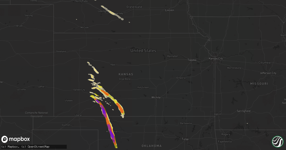
Hail Map in Kansas on June 19, 2019
Get this storm
June 19 map
$229
one time, instant access
Download today. No call, no setup
Keep the $229
Bought the map and want the full workflow? Apply the entire $229 to a subscription within 7 days. None of it is wasted.
Every map, not just this one
This buys you this map. Subscription and you get every map we run, in the markets you choose from a few cities to whole states to nationwide. Plus real-time alerts the moment a storm fires.
Contact data
Name, contact info, occupancy, even credit band for addresses in the footprint. You go from where it hit to who to call.
Become the source they trust
Unlimited branding weather history reports on demand. You already have the documented answer ready for the property owner, and you are the one who showed up with it.
Property data and RoofTrace estimates
Pull up any address you have got, its value and the exact code rules for that jurisdiction, straight from One Click Code. Then RoofTrace estimates the squares, pitch, and roof value, priced the way you price.
Storm reports in Kansas
Kansas
| Date | Description |
|---|---|
| 06/19/20196:55 PM CDT | A local report indicates 1.50 inch wind near 7 NNE AETNA |
| 06/19/20196:55 PM CDT | A local report indicates 1.50 inch wind near 7 SW SUN CITY |
| 06/19/20196:42 PM CDT | A local report indicates 2.75 inch wind near ASHLAND |
| 06/19/20195:58 PM CDT | A local report indicates 1.00 inch wind near 1 WSW GREENSBURG |
| 06/19/20195:30 PM CDT | A local report indicates 3.00 inch wind near 7 N MINNEOLA |
| 06/19/20195:30 PM CDT | A local report indicates 2.00 inch wind near 6 N MINNEOLA |
| 06/19/20195:00 PM CDT | Reported through social media. |
| 06/19/20194:59 PM CDT | A local report indicates 60 MPH wind near 4 NW SPEARVILLE |
| 06/19/20194:55 PM CDT | A local report indicates 1.00 inch wind near 1 WNW DODGE CITY |
| 06/19/20194:54 PM CDT | Reported on social media. |
| 06/19/20194:49 PM CDT | A local report indicates 1.00 inch wind near 3 NW DODGE CITY |
| 06/19/20194:48 PM CDT | Hail lasted until 452 pm. |
| 06/19/20194:35 PM CDT | A local report indicates 1.00 inch wind near 4 ESE JETMORE |
| 06/19/20194:34 PM CDT | A local report indicates 1.00 inch wind near JETMORE |
| 06/19/20194:20 PM CDT | A local report indicates 60 MPH wind near 4 W JETMORE |
| 06/19/20192:12 AM CDT | At 711 PM CDT, a severe thunderstorm was located 7 miles east of Aetna, moving southeast at 35 mph. HAZARD...Ping pong ball size hail and 60 mph wind gusts. SOURCE...Radar indicated. Trained spotters reported ping pong ball size hail 7 miles north northeast of Aetna, Kansas. IMPACT...People and animals outdoors will be injured. Expect hail damage to roofs, siding, windows, and vehicles. Expect wind damage to roofs, siding, and trees. Locations impacted include... Alva, Cherokee, Dacoma, Lambert, Avard, Ingersoll, Capron and Hopeton. |
| 06/19/20191:56 AM CDT | At 655 PM CDT, a severe thunderstorm was located 8 miles northeast of Aetna, moving southeast at 35 mph. HAZARD...Two inch hail and 70 mph wind gusts. SOURCE...Public. Public reported ping pong ball size hail 14 east of Coldwater. IMPACT...People and animals outdoors will be injured. Expect hail damage to roofs, siding, windows, and vehicles. Expect considerable tree damage. Wind damage is also likely to mobile homes, roofs, and outbuildings. Locations impacted include... Kiowa, Hardtner, Hazelton and Aetna. |
| 06/19/20191:49 AM CDT | At 648 PM CDT, a severe thunderstorm was located near Ashland, moving southeast at 25 mph. This is a very dangerous storm. HAZARD...Baseball size hail and 60 mph wind gusts. SOURCE...Radar indicated. Baseball size hail was reported in Ashland, Kansas. IMPACT...People and animals outdoors will be severely injured. Expect shattered windows, extensive damage to roofs, siding, and vehicles. Locations impacted include... Buffalo and Selman. |
| 06/19/20191:28 AM CDT | At 628 PM CDT, a severe thunderstorm was located near Sun City, moving southeast at 45 mph. HAZARD...Two inch hail and 70 mph wind gusts. SOURCE...Radar indicated. IMPACT...People and animals outdoors will be injured. Expect hail damage to roofs, siding, windows, and vehicles. Expect considerable tree damage. Wind damage is also likely to mobile homes, roofs, and outbuildings. Locations impacted include... Medicine Lodge, Sharon, Coats, Lake City, Sun City and Aetna. |
| 06/19/20191:18 AM CDT | At 618 PM CDT, a severe thunderstorm was located near Clark State Lake, moving southeast at 35 mph. This is a very dangerous storm. HAZARD...Baseball size hail and 70 mph wind gusts. SOURCE...Radar indicated. IMPACT...People and animals outdoors will be severely injured. Expect shattered windows, extensive damage to roofs, siding, and vehicles. Locations impacted include... Ashland, Sitka and Clark State Lake. |
| 06/19/20191:08 AM CDT | At 607 PM CDT, a severe thunderstorm was located near Belvidere, moving southeast at 45 mph. HAZARD...70 mph wind gusts and ping pong ball size hail. SOURCE...Radar indicated. IMPACT...People and animals outdoors will be injured. Expect hail damage to roofs, siding, windows, and vehicles. Expect considerable tree damage. Wind damage is also likely to mobile homes, roofs, and outbuildings. Locations impacted include... Haviland, Sawyer, Coats, Sun City, Wilmore, Wellsford, Croft and Belvidere. |
| 06/19/201912:49 AM CDT | At 549 PM CDT, a severe thunderstorm was located very near Greensburg, moving southeast at 30 mph. HAZARD...70 mph wind gusts and ping pong ball size hail. SOURCE...Radar indicated. IMPACT...People and animals outdoors will be injured. Expect hail damage to roofs, siding, windows, and vehicles. Expect considerable tree damage. Wind damage is also likely to mobile homes, roofs, and outbuildings. Locations impacted include... Greensburg, Haviland, Mullinville, Wilmore, Wellsford, Croft and Belvidere. |
| 06/19/201912:46 AM CDT | At 546 PM CDT, a severe thunderstorm was located near Bloom, moving southeast at 30 mph. HAZARD...Golf ball size hail and 60 mph wind gusts. SOURCE...Radar indicated. IMPACT...People and animals outdoors will be injured. Expect hail damage to roofs, siding, windows, and vehicles. Expect wind damage to roofs, siding, and trees. Locations impacted include... Minneola, Bloom, Clark State Lake and Kingsdown. |
| 06/19/201912:29 AM CDT | At 529 PM CDT, a severe thunderstorm was located 9 miles north of Mullinville, moving southeast at 30 mph. HAZARD...Golf ball size hail and 70 mph wind gusts. SOURCE...Radar indicated. IMPACT...People and animals outdoors will be injured. Expect hail damage to roofs, siding, windows, and vehicles. Expect considerable tree damage. Wind damage is also likely to mobile homes, roofs, and outbuildings. Locations impacted include... Greensburg and Mullinville. |
| 06/19/201912:09 AM CDT | At 509 PM CDT, a severe thunderstorm was located 8 miles east of Ensign, moving southeast at 25 mph. HAZARD...60 mph wind gusts and half dollar size hail. SOURCE...Radar indicated. IMPACT...Hail damage to vehicles is expected. Expect wind damage to roofs, siding, and trees. Locations impacted include... Minneola, Ford and Bloom. |
| 06/18/201911:58 PM CDT | At 458 PM CDT, a severe thunderstorm was located near Bellefont, moving southeast at 25 mph. HAZARD...70 mph wind gusts and ping pong ball size hail. SOURCE...Radar indicated. IMPACT...People and animals outdoors will be injured. Expect hail damage to roofs, siding, windows, and vehicles. Expect considerable tree damage. Wind damage is also likely to mobile homes, roofs, and outbuildings. Locations impacted include... Kinsley, Spearville, Lewis, Offerle, Windhorst and Bellefont. |
| 06/18/201911:50 PM CDT | At 449 PM CDT, a severe thunderstorm was located near Howell, moving east at 25 mph. HAZARD...Quarter size hail. SOURCE...Public. The public has reported has reported quarter size hail in Dodge City. IMPACT...Damage to vehicles is expected. Locations impacted include... Dodge City, Ensign, Ft. Dodge and Howell. |
| 06/18/201911:35 PM CDT | At 435 PM CDT, a severe thunderstorm was located near Jetmore, moving southeast at 30 mph. HAZARD...60 mph wind gusts and quarter size hail. SOURCE...Trained spotters. Trained spotters have reported quarter size hail and winds near 60 mph at Jetmore. IMPACT...Hail damage to vehicles is expected. Expect wind damage to roofs, siding, and trees. Locations impacted include... Jetmore, Spearville, Hanston, Offerle, Windhorst and Bellefont. |
| 06/18/201911:14 PM CDT | At 413 PM CDT, a severe thunderstorm was located near Jetmore, moving southeast at 30 mph. HAZARD...60 mph wind gusts and nickel size hail. SOURCE...Radar indicated. IMPACT...Expect damage to roofs, siding, and trees. Locations impacted include... Jetmore and Hanston. |
| 06/18/20197:10 PM CDT | A local report indicates 1.50 inch wind near 9 S SITKA |
All States Impacted by Hail Map on June 19, 2019
Cities Impacted by Hail Map on June 19, 2019
- Jordan, MT
- Pine Ridge, SD
- Benton, MO
- Richey, MT
- Lambert, MT
- Walnut Springs, TX
- Woodward, OK
- Bruceton, TN
- Huntingdon, TN
- Hollow Rock, TN
- Cimarron, KS
- Rattan, OK
- Douglas, WY
- Hot Springs, SD
- Oelrichs, SD
- Wickes, AR
- Cove, AR
- Vandervoort, AR
- Dayton, WY
- Wyola, MT
- Parkman, WY
- Alba, TX
- Yantis, TX
- Mineola, TX
- Quitman, TX
- Little Rock, AR
- Hamilton, TX
- Hico, TX
- Wilmore, KS
- Lake City, KS
- Greensburg, KS
- Alva, OK
- Haviland, KS
- Sun City, KS
- Medicine Lodge, KS
- Bivins, TX
- Vivian, LA
- Rodessa, LA
- Ida, LA
- Hulett, WY
- Malden, MO
- Campbell, MO
- Bernie, MO
- Catron, MO
- Lilbourn, MO
- Broseley, MO
- Parma, MO
- Ideal, SD
- Hamill, SD
- Goldthwaite, TX
- Mullin, TX
- Priddy, TX
- Anselmo, NE
- Edgemont, SD
- Franklin, TX
- Marston, MO
- Portageville, MO
- Talpa, TX
- Fort Supply, OK
- Cape Girardeau, MO
- Manchester, TN
- Wartrace, TN
- Brockton, MT
- Poplar, MT
- Manderson, WY
- Hyattville, WY
- Thebes, IL
- Oran, MO
- Scott City, MO
- Chaffee, MO
- McClure, IL
- Gillette, WY
- Rozet, WY
- Paris, TX
- Pattonville, TX
- Blossom, TX
- Plain Dealing, LA
- Gilliam, LA
- Grannis, AR
- Vida, MT
- Mullinville, KS
- Chidester, AR
- Quinlan, TX
- Woodland, MS
- Indianola, MS
- Shaw, MS
- Beechgrove, TN
- Shelbyville, TN
- Bell Buckle, TN
- Kaycee, WY
- Havre, MT
- Nunnelly, TN
- Bon Aqua, TN
- Lyles, TN
- McCrory, AR
- Honey Grove, TX
- Lone Oak, TX
- Caddo Mills, TX
- Greenville, TX
- San Saba, TX
- Monroe, LA
- Kosse, TX
- Normangee, TX
- North Zulch, TX
- Bremond, TX
- Riesel, TX
- Reagan, TX
- Madisonville, TX
- Marlin, TX
- Marquez, TX
- Rohwer, AR
- McGehee, AR
- Arkansas City, AR
- Dallas, SD
- Winner, SD
- Sibley, LA
- Minden, LA
- Norman, AR
- Caddo Gap, AR
- Lance Creek, WY
- Newcastle, WY
- Honobia, OK
- Talihina, OK
- Hillsboro, TX
- Detroit, TX
- Hugo, OK
- Boswell, OK
- Pickton, TX
- Sulphur Springs, TX
- Dike, TX
- Saltillo, TX
- Seneca, NE
- Mullen, NE
- Merna, NE
- Valera, TX
- Burkett, TX
- Santa Anna, TX
- Bangs, TX
- Novice, TX
- Coleman, TX
- Presho, SD
- Kennebec, SD
- Snyder, TX
- Hermleigh, TX
- Glendive, MT
- Dodge City, KS
- Minneola, KS
- Ness City, KS
- Dighton, KS
- Beeler, KS
- Sondheimer, LA
- Pioneer, LA
- Transylvania, LA
- Epps, LA
- Lake Providence, LA
- Mena, AR
- Bronte, TX
- Wingate, TX
- Winters, TX
- Botkins, OH
- Carlisle, IN
- East Prairie, MO
- Augusta, AR
- Boyle, MS
- Melissa, TX
- Anna, TX
- Hinsdale, MT
- Gregory, SD
- Biscoe, AR
- Hazen, AR
- Des Arc, AR
- Emmet, AR
- Prescott, AR
- Albion, OK
- Nashoba, OK
- Russells Point, OH
- Lewistown, OH
- Huntsville, OH
- Rushsylvania, OH
- West Mansfield, OH
- Bellefontaine, OH
- Cooper, TX
- Enloe, TX
- Taylor, NE
- Brewster, NE
- Henderson, TX
- Overton, TX
- Watson, OK
- Iredell, TX
- Wingo, KY
- Water Valley, KY
- Emerson, AR
- Avinger, TX
- Hatfield, AR
- Mooringsport, LA
- Commerce, TX
- Princeton, TX
- Farmersville, TX
- Campbell, TX
- Mckinney, TX
- Blue Ridge, TX
- Celeste, TX
- Daingerfield, TX
- Hughes Springs, TX
- Merriman, NE
- Dudley, MO
- Dexter, MO
- Stumpy Point, NC
- Arp, TX
- Belcher, LA
- Jefferson, TX
- Benton, LA
- Cotton Valley, LA
- Oil City, LA
- Karnack, TX
- Buffalo, OK
- Hot Springs National Park, AR
- Cleveland, MS
- Ten Sleep, WY
- Clarksville, TX
- Bagwell, TX
- Pittsburg, TX
- Mount Pleasant, TX
- Jetmore, KS
- Windom, TX
- Valley Mills, TX
- Clifton, TX
- Ashland, KS
- Willow Hill, IL
- Abbott, TX
- West, TX
- Boca Raton, FL
- Bingham, NE
- Ashby, NE
- Ellsworth, NE
- Como, TX
- Winnsboro, TX
- Scroggins, TX
- Pecan Gap, TX
- Emory, TX
- Lone Star, TX
- Point, TX
- Edgewood, TX
- Wolfe City, TX
- Leonard, TX
- Cumby, TX
- Klondike, TX
- Gilmer, TX
- Ladonia, TX
- Leesburg, TX
- Ore City, TX
- Brashear, TX
- Mount Vernon, TX
- Grand Saline, TX
- Tryon, NE
- Sharon, OK
- Advance, MO
- Vici, OK
- Leedey, OK
- Lindsay, MT
- Bloomfield, MT
- Bucklin, KS
- Doddsville, MS
- Sunflower, MS
- Moorhead, MS
- Leland, MS
- Whitman, NE
- Hay Springs, NE
- Chadron, NE
- Hemingford, NE
- Comanche, TX
- Worland, WY
- Spearville, KS
- Miller City, IL
- West, MS
- Whitney, NE
- Philpot, KY
- Hawesville, KY
- Powderly, TX
- Arthur City, TX
- Crookston, NE
- Valentine, NE
- Dublin, TX
- Hanston, KS
- Ford, KS
- Offerle, KS
- Kinsley, KS
- Wright, KS
- Heavener, OK
- Bonham, TX
- Whitewright, TX
- Van Alstyne, TX
- Trenton, TX
- Spencerville, OK
- Fort Towson, OK
- Whitesboro, OK
- Muse, OK
- Marks, MS
- Brentwood, TN
- Jessieville, AR
- Jonesville, LA
- McGregor, TX
- Moody, TX
- Shawnee, WY
- Linden, TX
- Metropolis, IL
- Golconda, IL
- Mount Ida, AR
- Lometa, TX
- Idabel, OK
- Jackson Center, OH
- Anna, OH
- Overton, NE
- Eddyville, NE
- Lexington, NE
- Elm Creek, NE
- Odessa, NE
- Minden, NE
- Cozad, NE
- Axtell, NE
- Kearney, NE
- Gibsland, LA
- Wolf Point, MT
- Cody, NE
- Nenzel, NE
- Kilgore, NE
- Glen Rose, TX
- Kopperl, TX
- Morgan, TX
- Bennington, OK
- Sawyer, OK
- Paron, AR
- Lonsdale, AR
- Benton, AR
- Hot Springs Village, AR
- Valliant, OK
- Shreveport, LA
- Barksdale Afb, LA
- Dubberly, LA
- Foreman, AR
- Athens, LA
- Terrell, TX
- Annona, TX
- Lake Creek, TX
- Telephone, TX
- Petty, TX
- Wills Point, TX
- Broken Bow, OK
- Sumner, TX
- Royse City, TX
- Roxton, TX
- Grant, OK
- Haworth, OK
- Brookston, TX
- Celina, TX
- Bailey, TX
- Avery, TX
- Allen, TX
- Omaha, TX
- Naples, TX
- Ben Franklin, TX
- Deport, TX
- Bossier City, LA
- Wright City, OK
- Haughton, LA
- Bogata, TX
- Dodd City, TX
- Winfield, TX
- Sulphur Bluff, TX
- Princeton, LA
- Hosston, LA
- Garvin, OK
- Frisco, TX
- De Kalb, TX
- Maryneal, TX
- Loraine, TX
- Broken Bow, NE
- Poplar Bluff, MO
- Jonesboro, TX
- Fallon, MT
- Bigelow, AR
- Mayflower, AR
- Roland, AR
- Fisk, MO
- Roby, TX
- Rotan, TX
- Meridian, TX
- Nashville, TN
- Hyannis, NE
- Thompsons Station, TN
- Franklin, TN
- Fluvanna, TX
- Thedford, NE
- Lynchburg, OH
- Blackwell, TX
- Fowler, KS
- Gatesville, TX
- Adairsville, GA
- White, GA
- Vaiden, MS
- Wood Lake, NE
- Johnstown, NE
- Cohagen, MT
- Wounded Knee, SD
- Batesland, SD
- Brighton, TN
- Covington, TN
- Burlison, TN
- Waldron, AR
- Howe, OK
- Hayes Center, NE
- Columbia, TN
- Gove, KS
- McEwen, TN
- Funk, NE
- Heartwell, NE
- Troy, TX
- Brownsville, TN
- Brownwood, TX
- West Monroe, LA
- Rayville, LA
- Cross Plains, TX
- Terry, MT
- Sikeston, MO
- Mount Enterprise, TX
- Waco, TX
- Brockway, MT
- Greenwood, MS
- Coila, MS
- Waverly, TN
- Rufe, OK
- Ringold, OK
- China Spring, TX
- Turrell, AR
- Tyronza, AR
- Moorcroft, WY
- Avon, SD
- Tyndall, SD
- Haynesville, LA
- Devils Tower, WY
- Perryville, AR
- Houston, AR
- Taylorsville, KY
- Arnold, KS
- Utica, KS
- Quinter, KS
- Ransom, KS
- Zephyr, TX
- Richland Springs, TX
- Evant, TX
- Malta, MT
- Saco, MT
- Eagletown, OK
- Lake City, AR
- Bay, AR
- Bastrop, LA
- Oak Ridge, LA
- Collinston, LA
- Otis, CO
- Stephenville, TX
- Nevada, TX
- Ranchester, WY
- McKenzie, TN
- Ballinger, TX
- Clarkson, KY
- Cub Run, KY
- Texarkana, TX
- Ashdown, AR
- Taloga, OK
- Ensign, KS
- Camargo, OK
- Sidon, MS
- Pottsville, TX
- Mer Rouge, LA
- Bethel, OK
- Smithville, OK
- Brownwood, MO
- Whitewater, MO
- Tamms, IL
- Jonesboro, IL
- Sturdivant, MO
- Camden, TN
- Bloomfield, MO
- Fulton, KY
- Merigold, MS
- Benoit, MS
- Beulah, MS
- Rosedale, MS
- Nags Head, NC
- Laneville, TX
- Lodge Grass, MT
- Dickson, TN
- Charleston, MO
- Colt, AR
- Wappapello, MO
- Puxico, MO
- Cookville, TX
- Zanesfield, OH
- Ansley, NE
- Smyrna, TN
- Nolensville, TN
- Ainsworth, NE
- Park, KS
- De Queen, AR
- Gillham, AR
- Watson, AR
- Lorena, TX
- Cherry Valley, AR
- Wynne, AR
- Doniphan, MO
- Oxly, MO
- Tyler, TX
- Lusk, WY
- Searcy, AR
- Upton, WY
- Deville, LA
- Cairo, IL
- Mounds, IL
- Villa Ridge, IL
- Irving, TX
- Norton, TX
- De Valls Bluff, AR
- Fulton, AR
- Woodway, TX
- Hewitt, TX
- Amity, AR
- De Leon, TX
- Rushville, NE
- Gustine, TX
- Bee Spring, KY
- Dierks, AR
- Umpire, AR
- Long Pine, NE
- Sterlington, LA
- Ruston, LA
- Quitman, LA
- Sundance, WY
- Vardaman, MS
- Houston, MS
- Mantee, MS
- Crawford, TX
- Chilton, TX
- Lott, TX
- Earle, AR
- Gilmore, AR
- Bassett, AR
- Joiner, AR
- Frenchmans Bayou, AR
- Shelby, MS
- Story, AR
- Kevil, KY
- Ripley, TN
- Bryant, AR
- Alexander, AR
- Mabelvale, AR
- Bells, TN
- Jackson, TN
- Circle, MT
- Junction City, AR
- Sarepta, LA
- Delhi, LA
- Crawford, NE
- Garrison, TX
- Harrison, NE
- Coldwater, KS
- Sweetwater, TX
- Harviell, MO
- Texarkana, AR
- Donalsonville, GA
- Hurricane Mills, TN
- Blanket, TX
- Kingston Springs, TN
- Fairview, TN
- Burns, TN
- Hickory Ridge, AR
- Rison, AR
- Kingsland, AR
- New Johnsonville, TN
- Griffithville, AR
- Baird, TX
- Sargent, NE
- Winona, TX
- Lockesburg, AR
- Mayfield, KY
- Scott, AR
- North Little Rock, AR
- Snow, OK
- Little Elm, TX
- Hillsboro, OH
- Monticello, AR
- Dermott, AR
- Calvert City, KY
- Boaz, KY
- Melber, KY
- Hickory, KY
- Symsonia, KY
- Paducah, KY
- Purmela, TX
- Sheridan, WY
- Lonoke, AR
- Early, TX
- Rochelle, TX
- Carlton, TX
- Fayetteville, OH
- Mount Orab, OH
- Marsland, NE
- Maplewood, OH
- Quincy, OH
- Marble Hill, MO
- Grady, AR
- Tillar, AR
- Pickens, AR
- Dumas, AR
- Gothenburg, NE
- Fairmount, GA
- Rydal, GA
- Ector, TX
- Mart, TX
- Bryan, TX
- Hearne, TX
- Salt Lick, KY
- Morehead, KY
- Stapleton, NE
- Springfield, GA
- Tallulah, LA
- Williamsville, MO
- Germantown, MD
- Clarksburg, MD
- Boyds, MD
- Niobrara, NE
- Springfield, SD
- Spearsville, LA
- Hermitage, TN
- Mount Juliet, TN
- Spring Hill, TN
- Primm Springs, TN
- Proctor, AR
- Price, TX
- Selman City, TX
- Troup, TX
- Antioch, TN
- La Vergne, TN
- Rosebud, TX
- Ira, TX
- Dothan, AL
- Webb, AL
- Plano, TX
- North Platte, NE
- Merino, CO
- Dallas, TX
- Long Branch, TX
- Buffalo, WY
- Mammoth Cave, KY
- Harleton, TX
- Brookesmith, TX
- Goldsboro, TX
- Lawn, TX
- Abilene, TX
- Rockwall, TX
- Lavon, TX
- Colorado City, TX
- Eddy, TX
- Santa Fe, TN
- Hope, AR
- Lewisville, AR
- Vidalia, LA
- Lampasas, TX
- Centerville, TN
- Tutwiler, MS
- Cascilla, MS
- Charleston, MS
- Roseland, NE
- Forsyth, MO
- Brady, NE
- Essex, MO
- Justiceburg, TX
- Rutherfordton, NC
- Mutual, OK
- Fairdealing, MO
- Halsey, NE
- Clermont, FL
- Winter Garden, FL
- Kissimmee, FL
- Orlando, FL
- Chapel Hill, TN
- Eagleville, TN
- College Grove, TN
- Rockvale, TN
- Unionville, TN
- Pheba, MS
- Drew, MS
- Sturgis, MS
- Crossett, AR
- Magnolia, AR
- Montrose, AR
- Glendora, MS
- Eudora, AR
- Wilmar, AR
- Gunnison, MS
- Gore Springs, MS
- Kilmichael, MS
- Starkville, MS
- Ruleville, MS
- North Carrollton, MS
- Itta Bena, MS
- Hampton, AR
- Waldo, AR
- Minter City, MS
- Mathiston, MS
- Parkdale, AR
- Buckner, AR
- Hollandale, MS
- Garland City, AR
- Hamburg, AR
- Schlater, MS
- Grenada, MS
- Stewart, MS
- Bellefontaine, MS
- Ackerman, MS
- Fouke, AR
- Winona, MS
- Stephens, AR
- Willisville, AR
- Carrollton, MS
- Stamps, AR
- Jersey, AR
- Smackover, AR
- Philipp, MS
- Cedarbluff, MS
- Winchester, AR
- Holcomb, MS
- Greenville, MS
- El Dorado, AR
- Banks, AR
- Warren, AR
- Mississippi State, MS
- Inverness, MS
- Fountain Hill, AR
- Mound Bayou, MS
- Walthall, MS
- Columbus, MS
- Star City, AR
- Calhoun City, MS
- Calion, AR
- Harrell, AR
- Strong, AR
- Camden, AR
- Hermitage, AR
- Lake Village, AR
- Maben, MS
- McNeil, AR
- McCarley, MS
- Mount Holly, AR
- Portland, AR
- Eupora, MS
- Duck Hill, MS
- West Point, MS
- Rosston, AR
- Louann, AR
- Hawkins, TX
- Fruitvale, TX
- Cabot, AR
- Ward, AR
- Austin, AR
- Sherwood, AR
- Jacksonville, AR
- Royal, AR
- Keo, AR
- Mountain Pine, AR
- Little Rock Air Force Base, AR
- Humnoke, AR
- Bauxite, AR
- Maumelle, AR
- England, AR
- Carlisle, AR
- Ulm, AR
- Stuttgart, AR
- Parkin, AR
- Horn Lake, MS
- Memphis, TN
- Germantown, TN
- Olive Branch, MS
- Cordova, TN
- Hughes, AR
- Southaven, MS
- Lake Cormorant, MS
- Walls, MS
- Denmark, TN
- Stanton, TN
- Diana, TX
- Waskom, TX
- Longview, TX
- Hallsville, TX
- Marshall, TX


