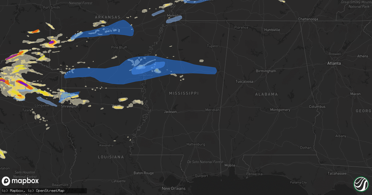
Hail Map in Mississippi on June 19, 2019
Get this storm
June 19 map
$229
one time, instant access
Download today. No call, no setup
Keep the $229
Bought the map and want the full workflow? Apply the entire $229 to a subscription within 7 days. None of it is wasted.
Every map, not just this one
This buys you this map. Subscription and you get every map we run, in the markets you choose from a few cities to whole states to nationwide. Plus real-time alerts the moment a storm fires.
Contact data
Name, contact info, occupancy, even credit band for addresses in the footprint. You go from where it hit to who to call.
Become the source they trust
Unlimited branding weather history reports on demand. You already have the documented answer ready for the property owner, and you are the one who showed up with it.
Property data and RoofTrace estimates
Pull up any address you have got, its value and the exact code rules for that jurisdiction, straight from One Click Code. Then RoofTrace estimates the squares, pitch, and roof value, priced the way you price.
Storm reports in Mississippi
Mississippi
| Date | Description |
|---|---|
| 06/19/20196:28 AM CDT | At 1128 PM CDT, a severe thunderstorm was located near Vance, or 11 miles northwest of Charleston, moving northeast at 55 mph. HAZARD...60 mph wind gusts. SOURCE...Radar indicated. IMPACT...Expect damage to roofs, siding, and trees. Locations impacted include... Oxford, Clarksdale, Batesville, Water Valley, Charleston, George Payne State Park, Holly Springs National Forest, John W Kyle State Park, Tutwiler, Bruce, Marks, Lambert, Coffeeville, Crowder, Sumner, Pope, Enid, Paynes, Dublin and Velma. |
| 06/19/20196:16 AM CDT | At 1115 PM CDT, severe thunderstorms were located along a line extending from 6 miles northeast of Minter City to near Sidon to near Midnight, moving east at 50 mph. HAZARD...70 mph wind gusts and quarter size hail. SOURCE...Radar indicated. IMPACT...Hail damage to vehicles is expected. Expect considerable tree damage. Wind damage is also likely to mobile homes, roofs, and outbuildings. Severe thunderstorms will be near... Greenwood and Seven Pines around 1120 PM CDT. Leflore and Malmaison around 1125 PM CDT. Thornton, Holcomb and Coila around 1130 PM CDT. North Carrollton around 1135 PM CDT. Grenada, Tchula, Howard, Bew Springs and Tolarville around 1140 PM CDT. Winona, Vaiden and Brozville around 1145 PM CDT. Lexington and Elliott around 1150 PM CDT. Franklin around 1155 PM CDT.Other locations impacted by these severe thunderstorms includeWalthall, Carrollton, Sallis and West. |
| 06/19/20196:15 AM CDT | At 1115 PM CDT, severe thunderstorms were located along a line extending from 7 miles southwest of Marked Tree to 7 miles northwest of North Tunica, moving east at 60 mph. HAZARD...70 mph wind gusts. SOURCE...Radar indicated. IMPACT...Expect considerable tree damage. Damage is likely to mobile homes, roofs, and outbuildings. Locations impacted include... Bartlett, Southaven, Collierville, Germantown, Olive Branch, West Memphis, Horn Lake, Hernando, Marion, Millington, Covington, Marked Tree, Earle, Hughes, Parkin, Tyronza, Cordova, T O Fuller State Park, Meeman Shelby Forest State Park and Memphis. |
| 06/19/20196:02 AM CDT | At 1102 PM CDT, a severe thunderstorm was located near Swiftown, or near Moorhead, moving east at 45 mph. HAZARD...70 mph wind gusts and quarter size hail. SOURCE...Radar indicated. IMPACT...Hail damage to vehicles is expected. Expect considerable tree damage. Wind damage is also likely to mobile homes, roofs, and outbuildings. This severe thunderstorm will be near... Quito around 1110 PM CDT. Sidon around 1120 PM CDT. Seven Pines around 1130 PM CDT.Other locations impacted by this severe thunderstorm include MorganCity and Cruger. |
| 06/19/20195:52 AM CDT | At 1052 PM CDT, severe thunderstorms were located along a line extending from near Kings to near Moorhead, moving east at 55 mph. HAZARD...70 mph wind gusts. SOURCE...Radar indicated. IMPACT...Expect considerable tree damage. Damage is likely to mobile homes, roofs, and outbuildings. Locations impacted include... Clarksdale, Batesville, Charleston, George Payne State Park, Tutwiler, Marks, Lambert, Crowder, Webb, Sumner, Pope, Belen, Enid, Paynes, Dublin, Curtis Station, Vance, Sherard, Scobey and Courtland. |
| 06/19/20194:54 AM CDT | Numerous homes sustained roof damage in the west haven subdivision. Numerous trees were snapped or downed. Several sheds were damaged or destroyed. |
| 06/19/20194:12 AM CDT | Several trees downed on 8 penny lane. |
| 06/19/20193:25 AM CDT | Corrects previous tstm wnd dmg report from 4 sse redwood. Trees and power lines downed in the piney woods mobile home park just off oak ridge road. |
| 06/19/20192:46 AM CDT | The roof of the delta state university airport hangar was damaged when a piece of metal roofing was peeled off and caused damage to the hangar door. |
| 06/19/20192:25 AM CDT | Trees and power lines downed in the piney woods mobile home park just off oak ridge road. |
| 06/19/20191:30 AM CDT | A large limb fell on a house near new hope... Ms... Reported via social media. |
| 06/19/20191:30 AM CDT | Large tree branches down on vehicle in tremont. |
| 06/19/201912:56 AM CDT | A tree split in half at wtva studios. |
| 06/19/201912:50 AM CDT | Report of a sign blown down at the highway 82 and highway 45 alternate intersection. |
| 06/19/201912:50 AM CDT | Tree downed on turtleneck road near madden. |
| 06/19/201912:50 AM CDT | Report of downed trees with some on houses in the city of west point. |
| 06/19/201912:49 AM CDT | Power line down near airport road. |
| 06/19/201912:45 AM CDT | Power outages reported near the lawndale community. |
| 06/19/201912:40 AM CDT | Large tree uprooted... Numerous limbs down... And roof blown off of trailer near the intersection of self creek rd and fate douglas rd. In oktibbeha county... Reported |
| 06/19/201912:40 AM CDT | Tree down on a home near apple street. Report relayed via social media. |
| 06/19/201912:40 AM CDT | Report of a tree fell on a home on cole street. |
| 06/19/201912:30 AM CDT | Tree and powerline downed on highway 35 in between the tyson chicken plant and singleton. |
| 06/19/201912:20 AM CDT | Tree downed on highway 15 south of mathiston. |
| 06/19/201912:15 AM CDT | Reports of trees and powerlines downed across the county. |
| 06/19/201912:13 AM CDT | Reports of large limbs downed in the tomnolen and eupora area. Likely sub-severe wind gusts. |
| 06/18/201911:55 PM CDT | Report of a few trees downed on highway 51 in between goodman and durant. |
| 06/18/201911:55 PM CDT | A few trees down on highway 17s just north of pickens. |
| 06/18/201911:48 PM CDT | A tree fell on a house near winona... Ms... Reported via social media. |
| 06/18/201911:40 PM CDT | Multiple downed trees and powerlines down across the county and in the winona area. |
| 06/18/201911:40 PM CDT | Report of downed trees across the county. |
| 06/18/201911:35 PM CDT | Powerline downed on county road 286 near the grenada county line. |
| 06/18/201911:30 PM CDT | Reports of trees downed in the highway 17 and highway 35 area of carroll county. |
| 06/18/201911:22 PM CDT | Several trees and a few power lines down. |
| 06/18/201911:22 PM CDT | Numerous trees uprooted across the city. Including along cotton... Ray street... Grendad blvd and east market street. Several large limbs were also down. |
| 06/18/201911:10 PM CDT | Report of downed powerline at the 200 block of washington street in belzoni. |
| 06/18/201911:02 PM CDT | Large trees snapped. Mobile home on bush holeman rd had significant damage. The roof and some siding were peeled off. Roofing was blown nearly 100 feet across the road. |
| 06/18/201910:46 PM CDT | 2 street lights at the quality inn were blown down. Pieces of roof being blown off. |
| 06/18/201910:46 PM CDT | Corrects previous tstm wnd dmg report from 2 wnw cleveland. The roof of an airport hangar was damaged along with the hangar door. |
| 06/18/201910:45 PM CDT | Report of trees down in avon area. Windows were damaged at a residence... A pier was damaged and a boat was blown over on truck. Relayed via social media. |
| 06/18/201910:45 PM CDT | Numerous trees were down. Several power poles were snapped. Power was out across the area. |
| 06/18/201910:42 PM CDT | Rough 10 power poles snapped and several trees down. Est 80-90 mph winds. |
| 06/18/201910:40 PM CDT | Trees and power lines were blown down in cleveland. Sporadic trees were blown down across the county. |
| 06/18/201910:31 PM CDT | Measured at mid-delta regional airport. |
| 06/18/201910:30 PM CDT | Roof peeled off of several businesses in downtown rosedale. |
| 06/18/201910:30 PM CDT | 80-90 mph winds snapped several power poles. Trees were also down in and around rosedale. |
| 06/18/201910:30 PM CDT | *** 1 fatal *** tree fell on a mobile home... Causing 1 fatality... On west county line road... Just west of north broadway extended. |
| 06/18/201910:29 PM CDT | Tree fell through roof of school building. Bleachers were flipped and displaced at the high school. Several large limbs fell on a car. Reported via social media. |
| 06/18/201910:28 PM CDT | 80-90 mph winds snapped several power poles. Trees were down in and around beulah as well. |
| 06/18/201910:27 PM CDT | A swath of 80-95 mph winds occurred in s bolivar county along hwy 450. Here roughly 10 power poles were snapped. The only homestead around had minor roof damage and all |
| 06/18/201910:25 PM CDT | A few trees and power lines down along with many large limbs. |
| 06/18/201910:23 PM CDT | Several trees down and snapped off. Est 60-70 mph winds. |
| 06/18/201910:22 PM CDT | A swath of 80-90 mph winds impacted far n washington county near winterville along hwy 1 and areas along the bolivar line. Much of this was numerous uprooted... Snapped |
| 06/18/201910:20 PM CDT | Large limbs downed in this area between lamont and scott in bolivar county. |
All States Impacted by Hail Map on June 19, 2019
Cities Impacted by Hail Map on June 19, 2019
- Jordan, MT
- Pine Ridge, SD
- Benton, MO
- Richey, MT
- Lambert, MT
- Walnut Springs, TX
- Woodward, OK
- Bruceton, TN
- Huntingdon, TN
- Hollow Rock, TN
- Cimarron, KS
- Rattan, OK
- Douglas, WY
- Hot Springs, SD
- Oelrichs, SD
- Wickes, AR
- Cove, AR
- Vandervoort, AR
- Dayton, WY
- Wyola, MT
- Parkman, WY
- Alba, TX
- Yantis, TX
- Mineola, TX
- Quitman, TX
- Little Rock, AR
- Hamilton, TX
- Hico, TX
- Wilmore, KS
- Lake City, KS
- Greensburg, KS
- Alva, OK
- Haviland, KS
- Sun City, KS
- Medicine Lodge, KS
- Bivins, TX
- Vivian, LA
- Rodessa, LA
- Ida, LA
- Hulett, WY
- Malden, MO
- Campbell, MO
- Bernie, MO
- Catron, MO
- Lilbourn, MO
- Broseley, MO
- Parma, MO
- Ideal, SD
- Hamill, SD
- Goldthwaite, TX
- Mullin, TX
- Priddy, TX
- Anselmo, NE
- Edgemont, SD
- Franklin, TX
- Marston, MO
- Portageville, MO
- Talpa, TX
- Fort Supply, OK
- Cape Girardeau, MO
- Manchester, TN
- Wartrace, TN
- Brockton, MT
- Poplar, MT
- Manderson, WY
- Hyattville, WY
- Thebes, IL
- Oran, MO
- Scott City, MO
- Chaffee, MO
- McClure, IL
- Gillette, WY
- Rozet, WY
- Paris, TX
- Pattonville, TX
- Blossom, TX
- Plain Dealing, LA
- Gilliam, LA
- Grannis, AR
- Vida, MT
- Mullinville, KS
- Chidester, AR
- Quinlan, TX
- Woodland, MS
- Indianola, MS
- Shaw, MS
- Beechgrove, TN
- Shelbyville, TN
- Bell Buckle, TN
- Kaycee, WY
- Havre, MT
- Nunnelly, TN
- Bon Aqua, TN
- Lyles, TN
- McCrory, AR
- Honey Grove, TX
- Lone Oak, TX
- Caddo Mills, TX
- Greenville, TX
- San Saba, TX
- Monroe, LA
- Kosse, TX
- Normangee, TX
- North Zulch, TX
- Bremond, TX
- Riesel, TX
- Reagan, TX
- Madisonville, TX
- Marlin, TX
- Marquez, TX
- Rohwer, AR
- McGehee, AR
- Arkansas City, AR
- Dallas, SD
- Winner, SD
- Sibley, LA
- Minden, LA
- Norman, AR
- Caddo Gap, AR
- Lance Creek, WY
- Newcastle, WY
- Honobia, OK
- Talihina, OK
- Hillsboro, TX
- Detroit, TX
- Hugo, OK
- Boswell, OK
- Pickton, TX
- Sulphur Springs, TX
- Dike, TX
- Saltillo, TX
- Seneca, NE
- Mullen, NE
- Merna, NE
- Valera, TX
- Burkett, TX
- Santa Anna, TX
- Bangs, TX
- Novice, TX
- Coleman, TX
- Presho, SD
- Kennebec, SD
- Snyder, TX
- Hermleigh, TX
- Glendive, MT
- Dodge City, KS
- Minneola, KS
- Ness City, KS
- Dighton, KS
- Beeler, KS
- Sondheimer, LA
- Pioneer, LA
- Transylvania, LA
- Epps, LA
- Lake Providence, LA
- Mena, AR
- Bronte, TX
- Wingate, TX
- Winters, TX
- Botkins, OH
- Carlisle, IN
- East Prairie, MO
- Augusta, AR
- Boyle, MS
- Melissa, TX
- Anna, TX
- Hinsdale, MT
- Gregory, SD
- Biscoe, AR
- Hazen, AR
- Des Arc, AR
- Emmet, AR
- Prescott, AR
- Albion, OK
- Nashoba, OK
- Russells Point, OH
- Lewistown, OH
- Huntsville, OH
- Rushsylvania, OH
- West Mansfield, OH
- Bellefontaine, OH
- Cooper, TX
- Enloe, TX
- Taylor, NE
- Brewster, NE
- Henderson, TX
- Overton, TX
- Watson, OK
- Iredell, TX
- Wingo, KY
- Water Valley, KY
- Emerson, AR
- Avinger, TX
- Hatfield, AR
- Mooringsport, LA
- Commerce, TX
- Princeton, TX
- Farmersville, TX
- Campbell, TX
- Mckinney, TX
- Blue Ridge, TX
- Celeste, TX
- Daingerfield, TX
- Hughes Springs, TX
- Merriman, NE
- Dudley, MO
- Dexter, MO
- Stumpy Point, NC
- Arp, TX
- Belcher, LA
- Jefferson, TX
- Benton, LA
- Cotton Valley, LA
- Oil City, LA
- Karnack, TX
- Buffalo, OK
- Hot Springs National Park, AR
- Cleveland, MS
- Ten Sleep, WY
- Clarksville, TX
- Bagwell, TX
- Pittsburg, TX
- Mount Pleasant, TX
- Jetmore, KS
- Windom, TX
- Valley Mills, TX
- Clifton, TX
- Ashland, KS
- Willow Hill, IL
- Abbott, TX
- West, TX
- Boca Raton, FL
- Bingham, NE
- Ashby, NE
- Ellsworth, NE
- Como, TX
- Winnsboro, TX
- Scroggins, TX
- Pecan Gap, TX
- Emory, TX
- Lone Star, TX
- Point, TX
- Edgewood, TX
- Wolfe City, TX
- Leonard, TX
- Cumby, TX
- Klondike, TX
- Gilmer, TX
- Ladonia, TX
- Leesburg, TX
- Ore City, TX
- Brashear, TX
- Mount Vernon, TX
- Grand Saline, TX
- Tryon, NE
- Sharon, OK
- Advance, MO
- Vici, OK
- Leedey, OK
- Lindsay, MT
- Bloomfield, MT
- Bucklin, KS
- Doddsville, MS
- Sunflower, MS
- Moorhead, MS
- Leland, MS
- Whitman, NE
- Hay Springs, NE
- Chadron, NE
- Hemingford, NE
- Comanche, TX
- Worland, WY
- Spearville, KS
- Miller City, IL
- West, MS
- Whitney, NE
- Philpot, KY
- Hawesville, KY
- Powderly, TX
- Arthur City, TX
- Crookston, NE
- Valentine, NE
- Dublin, TX
- Hanston, KS
- Ford, KS
- Offerle, KS
- Kinsley, KS
- Wright, KS
- Heavener, OK
- Bonham, TX
- Whitewright, TX
- Van Alstyne, TX
- Trenton, TX
- Spencerville, OK
- Fort Towson, OK
- Whitesboro, OK
- Muse, OK
- Marks, MS
- Brentwood, TN
- Jessieville, AR
- Jonesville, LA
- McGregor, TX
- Moody, TX
- Shawnee, WY
- Linden, TX
- Metropolis, IL
- Golconda, IL
- Mount Ida, AR
- Lometa, TX
- Idabel, OK
- Jackson Center, OH
- Anna, OH
- Overton, NE
- Eddyville, NE
- Lexington, NE
- Elm Creek, NE
- Odessa, NE
- Minden, NE
- Cozad, NE
- Axtell, NE
- Kearney, NE
- Gibsland, LA
- Wolf Point, MT
- Cody, NE
- Nenzel, NE
- Kilgore, NE
- Glen Rose, TX
- Kopperl, TX
- Morgan, TX
- Bennington, OK
- Sawyer, OK
- Paron, AR
- Lonsdale, AR
- Benton, AR
- Hot Springs Village, AR
- Valliant, OK
- Shreveport, LA
- Barksdale Afb, LA
- Dubberly, LA
- Foreman, AR
- Athens, LA
- Terrell, TX
- Annona, TX
- Lake Creek, TX
- Telephone, TX
- Petty, TX
- Wills Point, TX
- Broken Bow, OK
- Sumner, TX
- Royse City, TX
- Roxton, TX
- Grant, OK
- Haworth, OK
- Brookston, TX
- Celina, TX
- Bailey, TX
- Avery, TX
- Allen, TX
- Omaha, TX
- Naples, TX
- Ben Franklin, TX
- Deport, TX
- Bossier City, LA
- Wright City, OK
- Haughton, LA
- Bogata, TX
- Dodd City, TX
- Winfield, TX
- Sulphur Bluff, TX
- Princeton, LA
- Hosston, LA
- Garvin, OK
- Frisco, TX
- De Kalb, TX
- Maryneal, TX
- Loraine, TX
- Broken Bow, NE
- Poplar Bluff, MO
- Jonesboro, TX
- Fallon, MT
- Bigelow, AR
- Mayflower, AR
- Roland, AR
- Fisk, MO
- Roby, TX
- Rotan, TX
- Meridian, TX
- Nashville, TN
- Hyannis, NE
- Thompsons Station, TN
- Franklin, TN
- Fluvanna, TX
- Thedford, NE
- Lynchburg, OH
- Blackwell, TX
- Fowler, KS
- Gatesville, TX
- Adairsville, GA
- White, GA
- Vaiden, MS
- Wood Lake, NE
- Johnstown, NE
- Cohagen, MT
- Wounded Knee, SD
- Batesland, SD
- Brighton, TN
- Covington, TN
- Burlison, TN
- Waldron, AR
- Howe, OK
- Hayes Center, NE
- Columbia, TN
- Gove, KS
- McEwen, TN
- Funk, NE
- Heartwell, NE
- Troy, TX
- Brownsville, TN
- Brownwood, TX
- West Monroe, LA
- Rayville, LA
- Cross Plains, TX
- Terry, MT
- Sikeston, MO
- Mount Enterprise, TX
- Waco, TX
- Brockway, MT
- Greenwood, MS
- Coila, MS
- Waverly, TN
- Rufe, OK
- Ringold, OK
- China Spring, TX
- Turrell, AR
- Tyronza, AR
- Moorcroft, WY
- Avon, SD
- Tyndall, SD
- Haynesville, LA
- Devils Tower, WY
- Perryville, AR
- Houston, AR
- Taylorsville, KY
- Arnold, KS
- Utica, KS
- Quinter, KS
- Ransom, KS
- Zephyr, TX
- Richland Springs, TX
- Evant, TX
- Malta, MT
- Saco, MT
- Eagletown, OK
- Lake City, AR
- Bay, AR
- Bastrop, LA
- Oak Ridge, LA
- Collinston, LA
- Otis, CO
- Stephenville, TX
- Nevada, TX
- Ranchester, WY
- McKenzie, TN
- Ballinger, TX
- Clarkson, KY
- Cub Run, KY
- Texarkana, TX
- Ashdown, AR
- Taloga, OK
- Ensign, KS
- Camargo, OK
- Sidon, MS
- Pottsville, TX
- Mer Rouge, LA
- Bethel, OK
- Smithville, OK
- Brownwood, MO
- Whitewater, MO
- Tamms, IL
- Jonesboro, IL
- Sturdivant, MO
- Camden, TN
- Bloomfield, MO
- Fulton, KY
- Merigold, MS
- Benoit, MS
- Beulah, MS
- Rosedale, MS
- Nags Head, NC
- Laneville, TX
- Lodge Grass, MT
- Dickson, TN
- Charleston, MO
- Colt, AR
- Wappapello, MO
- Puxico, MO
- Cookville, TX
- Zanesfield, OH
- Ansley, NE
- Smyrna, TN
- Nolensville, TN
- Ainsworth, NE
- Park, KS
- De Queen, AR
- Gillham, AR
- Watson, AR
- Lorena, TX
- Cherry Valley, AR
- Wynne, AR
- Doniphan, MO
- Oxly, MO
- Tyler, TX
- Lusk, WY
- Searcy, AR
- Upton, WY
- Deville, LA
- Cairo, IL
- Mounds, IL
- Villa Ridge, IL
- Irving, TX
- Norton, TX
- De Valls Bluff, AR
- Fulton, AR
- Woodway, TX
- Hewitt, TX
- Amity, AR
- De Leon, TX
- Rushville, NE
- Gustine, TX
- Bee Spring, KY
- Dierks, AR
- Umpire, AR
- Long Pine, NE
- Sterlington, LA
- Ruston, LA
- Quitman, LA
- Sundance, WY
- Vardaman, MS
- Houston, MS
- Mantee, MS
- Crawford, TX
- Chilton, TX
- Lott, TX
- Earle, AR
- Gilmore, AR
- Bassett, AR
- Joiner, AR
- Frenchmans Bayou, AR
- Shelby, MS
- Story, AR
- Kevil, KY
- Ripley, TN
- Bryant, AR
- Alexander, AR
- Mabelvale, AR
- Bells, TN
- Jackson, TN
- Circle, MT
- Junction City, AR
- Sarepta, LA
- Delhi, LA
- Crawford, NE
- Garrison, TX
- Harrison, NE
- Coldwater, KS
- Sweetwater, TX
- Harviell, MO
- Texarkana, AR
- Donalsonville, GA
- Hurricane Mills, TN
- Blanket, TX
- Kingston Springs, TN
- Fairview, TN
- Burns, TN
- Hickory Ridge, AR
- Rison, AR
- Kingsland, AR
- New Johnsonville, TN
- Griffithville, AR
- Baird, TX
- Sargent, NE
- Winona, TX
- Lockesburg, AR
- Mayfield, KY
- Scott, AR
- North Little Rock, AR
- Snow, OK
- Little Elm, TX
- Hillsboro, OH
- Monticello, AR
- Dermott, AR
- Calvert City, KY
- Boaz, KY
- Melber, KY
- Hickory, KY
- Symsonia, KY
- Paducah, KY
- Purmela, TX
- Sheridan, WY
- Lonoke, AR
- Early, TX
- Rochelle, TX
- Carlton, TX
- Fayetteville, OH
- Mount Orab, OH
- Marsland, NE
- Maplewood, OH
- Quincy, OH
- Marble Hill, MO
- Grady, AR
- Tillar, AR
- Pickens, AR
- Dumas, AR
- Gothenburg, NE
- Fairmount, GA
- Rydal, GA
- Ector, TX
- Mart, TX
- Bryan, TX
- Hearne, TX
- Salt Lick, KY
- Morehead, KY
- Stapleton, NE
- Springfield, GA
- Tallulah, LA
- Williamsville, MO
- Germantown, MD
- Clarksburg, MD
- Boyds, MD
- Niobrara, NE
- Springfield, SD
- Spearsville, LA
- Hermitage, TN
- Mount Juliet, TN
- Spring Hill, TN
- Primm Springs, TN
- Proctor, AR
- Price, TX
- Selman City, TX
- Troup, TX
- Antioch, TN
- La Vergne, TN
- Rosebud, TX
- Ira, TX
- Dothan, AL
- Webb, AL
- Plano, TX
- North Platte, NE
- Merino, CO
- Dallas, TX
- Long Branch, TX
- Buffalo, WY
- Mammoth Cave, KY
- Harleton, TX
- Brookesmith, TX
- Goldsboro, TX
- Lawn, TX
- Abilene, TX
- Rockwall, TX
- Lavon, TX
- Colorado City, TX
- Eddy, TX
- Santa Fe, TN
- Hope, AR
- Lewisville, AR
- Vidalia, LA
- Lampasas, TX
- Centerville, TN
- Tutwiler, MS
- Cascilla, MS
- Charleston, MS
- Roseland, NE
- Forsyth, MO
- Brady, NE
- Essex, MO
- Justiceburg, TX
- Rutherfordton, NC
- Mutual, OK
- Fairdealing, MO
- Halsey, NE
- Clermont, FL
- Winter Garden, FL
- Kissimmee, FL
- Orlando, FL
- Chapel Hill, TN
- Eagleville, TN
- College Grove, TN
- Rockvale, TN
- Unionville, TN
- Pheba, MS
- Drew, MS
- Sturgis, MS
- Crossett, AR
- Magnolia, AR
- Montrose, AR
- Glendora, MS
- Eudora, AR
- Wilmar, AR
- Gunnison, MS
- Gore Springs, MS
- Kilmichael, MS
- Starkville, MS
- Ruleville, MS
- North Carrollton, MS
- Itta Bena, MS
- Hampton, AR
- Waldo, AR
- Minter City, MS
- Mathiston, MS
- Parkdale, AR
- Buckner, AR
- Hollandale, MS
- Garland City, AR
- Hamburg, AR
- Schlater, MS
- Grenada, MS
- Stewart, MS
- Bellefontaine, MS
- Ackerman, MS
- Fouke, AR
- Winona, MS
- Stephens, AR
- Willisville, AR
- Carrollton, MS
- Stamps, AR
- Jersey, AR
- Smackover, AR
- Philipp, MS
- Cedarbluff, MS
- Winchester, AR
- Holcomb, MS
- Greenville, MS
- El Dorado, AR
- Banks, AR
- Warren, AR
- Mississippi State, MS
- Inverness, MS
- Fountain Hill, AR
- Mound Bayou, MS
- Walthall, MS
- Columbus, MS
- Star City, AR
- Calhoun City, MS
- Calion, AR
- Harrell, AR
- Strong, AR
- Camden, AR
- Hermitage, AR
- Lake Village, AR
- Maben, MS
- McNeil, AR
- McCarley, MS
- Mount Holly, AR
- Portland, AR
- Eupora, MS
- Duck Hill, MS
- West Point, MS
- Rosston, AR
- Louann, AR
- Hawkins, TX
- Fruitvale, TX
- Cabot, AR
- Ward, AR
- Austin, AR
- Sherwood, AR
- Jacksonville, AR
- Royal, AR
- Keo, AR
- Mountain Pine, AR
- Little Rock Air Force Base, AR
- Humnoke, AR
- Bauxite, AR
- Maumelle, AR
- England, AR
- Carlisle, AR
- Ulm, AR
- Stuttgart, AR
- Parkin, AR
- Horn Lake, MS
- Memphis, TN
- Germantown, TN
- Olive Branch, MS
- Cordova, TN
- Hughes, AR
- Southaven, MS
- Lake Cormorant, MS
- Walls, MS
- Denmark, TN
- Stanton, TN
- Diana, TX
- Waskom, TX
- Longview, TX
- Hallsville, TX
- Marshall, TX


