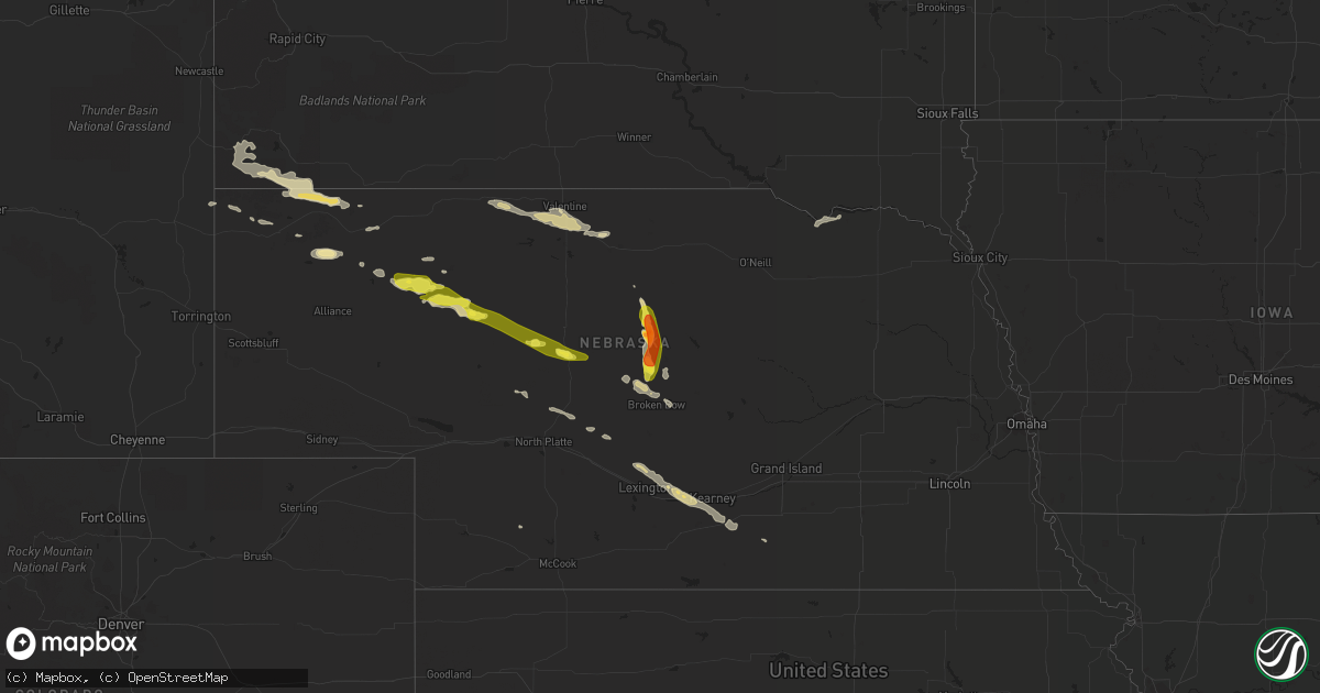
Hail Map in Nebraska on June 19, 2019
Get this storm
June 19 map
$229
one time, instant access
Download today. No call, no setup
Keep the $229
Bought the map and want the full workflow? Apply the entire $229 to a subscription within 7 days. None of it is wasted.
Every map, not just this one
This buys you this map. Subscription and you get every map we run, in the markets you choose from a few cities to whole states to nationwide. Plus real-time alerts the moment a storm fires.
Contact data
Name, contact info, occupancy, even credit band for addresses in the footprint. You go from where it hit to who to call.
Become the source they trust
Unlimited branding weather history reports on demand. You already have the documented answer ready for the property owner, and you are the one who showed up with it.
Property data and RoofTrace estimates
Pull up any address you have got, its value and the exact code rules for that jurisdiction, straight from One Click Code. Then RoofTrace estimates the squares, pitch, and roof value, priced the way you price.
Storm reports in Nebraska
Nebraska
| Date | Description |
|---|---|
| 06/19/20196:44 AM CDT | At 1144 PM MDT, a severe thunderstorm was located near Chadron, moving east at 50 mph. HAZARD...60 mph wind gusts and quarter size hail. SOURCE...Radar indicated. IMPACT...Hail damage to vehicles is expected. Expect wind damage to roofs, siding, and trees. Locations impacted include... Chadron. |
| 06/19/20196:41 AM CDT | At 1141 PM MDT, a severe thunderstorm was located 22 miles north of Ellsworth, or 24 miles south of Rushville, moving east at 50 mph. HAZARD...60 mph wind gusts and quarter size hail. SOURCE...Radar indicated. IMPACT...Hail damage to vehicles is expected. Expect wind damage to roofs, siding, and trees. Locations impacted include... Big Hill, Dipping Vat Meadow, Billys Lake, Morgan Lake, Wolf Hill, Argo Hill and Mother Lake.This includes Highway 250 between mile markers 16 and 25. |
| 06/19/20196:12 AM CDT | At 1111 PM MDT, a severe thunderstorm was located 13 miles southwest of Oelrichs, or 20 miles northwest of Chadron, moving southeast at 50 mph. HAZARD...60 mph wind gusts and quarter size hail. SOURCE...Radar indicated. IMPACT...Hail damage to vehicles is expected. Expect wind damage to roofs, siding, and trees. Locations impacted include... Chadron and Chadron Airport. |
| 06/19/20196:01 AM CDT | At 1100 PM MDT, a severe thunderstorm was located 9 miles northeast of Ardmore, or 22 miles southeast of Edgemont, moving east at 40 mph. HAZARD...60 mph wind gusts and half dollar size hail. SOURCE...Radar indicated. IMPACT...Hail damage to vehicles is expected. Expect wind damage to roofs, siding, and trees. This severe thunderstorm will remain over mainly rural areas of southeastern Fall River County, south of Oelrichs. |
| 06/19/20195:54 AM CDT | At 1054 PM MDT, a severe thunderstorm was located 8 miles northeast of Box Butte Dam, or 17 miles southwest of Hay Springs, moving east at 40 mph. HAZARD...60 mph wind gusts and quarter size hail. SOURCE...Radar indicated. IMPACT...Hail damage to vehicles is expected. Expect wind damage to roofs, siding, and trees. Locations impacted include... Diamond Lake, Smith Lake State Wildlife Management Area and Highway 250 crossing the Niobrara River.This includes Highway 250 between mile markers 16 and 38. |
| 06/19/20195:12 AM CDT | At 1012 PM MDT, a severe thunderstorm was located 5 miles southeast of Mule Creek Junction, or 14 miles west of Edgemont, moving east at 40 mph. HAZARD...60 mph wind gusts and half dollar size hail. SOURCE...Radar indicated. IMPACT...Hail damage to vehicles is expected. Expect wind damage to roofs, siding, and trees. Locations impacted include... Edgemont, Provo, Rumford, Ardmore, Burdock, Cascade Falls and Angostura Reservoir. |
| 06/19/20193:44 AM CDT | At 844 PM CDT, a severe thunderstorm was located near Victoria Springs State Recreation Area, or 16 miles west of Taylor, moving south at 30 mph. HAZARD...Ping pong ball size hail. SOURCE...Trained weather spotters. IMPACT...People and animals outdoors will be injured. Expect damage to roofs, siding, windows, and vehicles. Locations impacted include... Broken Bow, Merna, Victoria Springs State Recreation Area, Weissert, Lillian, Milburn, Milburn Diversion Dam State Wildlife Management Area, Round Valley, Walworth and Gates.This includes the following highways... Highway 183 between mile markers 100 and 112. Highway 2 between mile markers 263 and 281. Highway 92 between mile markers 271 and 273. |
| 06/19/20192:54 AM CDT | At 753 PM CDT, a severe thunderstorm was located 7 miles east of Brewster, moving south at 15 mph. HAZARD...Golf ball size hail. SOURCE...Trained weather spotters. IMPACT...People and animals outdoors will be injured. Expect damage to roofs, siding, windows, and vehicles. Locations impacted include... Milburn, Milburn Diversion Dam State Wildlife Management Area, Almeria Meadow State Wildlife Management Area, Gates and Almeria. |
| 06/19/20192:15 AM CDT | At 714 PM CDT, a severe thunderstorm was located 11 miles northeast of Brewster, moving southeast at 20 mph. HAZARD...60 mph wind gusts and half dollar size hail. SOURCE...Radar indicated. IMPACT...Hail damage to vehicles is expected. Expect wind damage to roofs, siding, and trees. Locations impacted include... Almeria Meadow State Wildlife Management Area, Almeria and Fox Bayou.This includes Highway 183 between mile markers 130 and 131. |
| 06/19/20191:00 AM CDT | Hail up to quarter size. 0.20 inch rain in 20 minutes |
| 06/18/201910:31 PM CDT | At 331 PM CDT, a severe thunderstorm was located near Johnstown, or 13 miles west of Ainsworth, moving southeast at 20 mph. HAZARD...60 mph wind gusts and quarter size hail. SOURCE...Radar indicated. IMPACT...Hail damage to vehicles is expected. Expect wind damage to roofs, siding, and trees. Locations impacted include... Johnstown.This includes Highway 20 between mile markers 226 and 239. |
| 06/18/20198:45 PM CDT | Most stones were the size of quarters to half dollar. |
| 06/18/20198:40 PM CDT | A local report indicates 1.00 inch wind near 2 NW GATES |
| 06/18/20197:59 PM CDT | A local report indicates 1.75 inch wind near 8 ESE BREWSTER |
| 06/18/20197:32 PM CDT | A local report indicates 1.75 inch wind near 9 E BREWSTER |
All States Impacted by Hail Map on June 19, 2019
Cities Impacted by Hail Map on June 19, 2019
- Jordan, MT
- Pine Ridge, SD
- Benton, MO
- Richey, MT
- Lambert, MT
- Walnut Springs, TX
- Woodward, OK
- Bruceton, TN
- Huntingdon, TN
- Hollow Rock, TN
- Cimarron, KS
- Rattan, OK
- Douglas, WY
- Hot Springs, SD
- Oelrichs, SD
- Wickes, AR
- Cove, AR
- Vandervoort, AR
- Dayton, WY
- Wyola, MT
- Parkman, WY
- Alba, TX
- Yantis, TX
- Mineola, TX
- Quitman, TX
- Little Rock, AR
- Hamilton, TX
- Hico, TX
- Wilmore, KS
- Lake City, KS
- Greensburg, KS
- Alva, OK
- Haviland, KS
- Sun City, KS
- Medicine Lodge, KS
- Bivins, TX
- Vivian, LA
- Rodessa, LA
- Ida, LA
- Hulett, WY
- Malden, MO
- Campbell, MO
- Bernie, MO
- Catron, MO
- Lilbourn, MO
- Broseley, MO
- Parma, MO
- Ideal, SD
- Hamill, SD
- Goldthwaite, TX
- Mullin, TX
- Priddy, TX
- Anselmo, NE
- Edgemont, SD
- Franklin, TX
- Marston, MO
- Portageville, MO
- Talpa, TX
- Fort Supply, OK
- Cape Girardeau, MO
- Manchester, TN
- Wartrace, TN
- Brockton, MT
- Poplar, MT
- Manderson, WY
- Hyattville, WY
- Thebes, IL
- Oran, MO
- Scott City, MO
- Chaffee, MO
- McClure, IL
- Gillette, WY
- Rozet, WY
- Paris, TX
- Pattonville, TX
- Blossom, TX
- Plain Dealing, LA
- Gilliam, LA
- Grannis, AR
- Vida, MT
- Mullinville, KS
- Chidester, AR
- Quinlan, TX
- Woodland, MS
- Indianola, MS
- Shaw, MS
- Beechgrove, TN
- Shelbyville, TN
- Bell Buckle, TN
- Kaycee, WY
- Havre, MT
- Nunnelly, TN
- Bon Aqua, TN
- Lyles, TN
- McCrory, AR
- Honey Grove, TX
- Lone Oak, TX
- Caddo Mills, TX
- Greenville, TX
- San Saba, TX
- Monroe, LA
- Kosse, TX
- Normangee, TX
- North Zulch, TX
- Bremond, TX
- Riesel, TX
- Reagan, TX
- Madisonville, TX
- Marlin, TX
- Marquez, TX
- Rohwer, AR
- McGehee, AR
- Arkansas City, AR
- Dallas, SD
- Winner, SD
- Sibley, LA
- Minden, LA
- Norman, AR
- Caddo Gap, AR
- Lance Creek, WY
- Newcastle, WY
- Honobia, OK
- Talihina, OK
- Hillsboro, TX
- Detroit, TX
- Hugo, OK
- Boswell, OK
- Pickton, TX
- Sulphur Springs, TX
- Dike, TX
- Saltillo, TX
- Seneca, NE
- Mullen, NE
- Merna, NE
- Valera, TX
- Burkett, TX
- Santa Anna, TX
- Bangs, TX
- Novice, TX
- Coleman, TX
- Presho, SD
- Kennebec, SD
- Snyder, TX
- Hermleigh, TX
- Glendive, MT
- Dodge City, KS
- Minneola, KS
- Ness City, KS
- Dighton, KS
- Beeler, KS
- Sondheimer, LA
- Pioneer, LA
- Transylvania, LA
- Epps, LA
- Lake Providence, LA
- Mena, AR
- Bronte, TX
- Wingate, TX
- Winters, TX
- Botkins, OH
- Carlisle, IN
- East Prairie, MO
- Augusta, AR
- Boyle, MS
- Melissa, TX
- Anna, TX
- Hinsdale, MT
- Gregory, SD
- Biscoe, AR
- Hazen, AR
- Des Arc, AR
- Emmet, AR
- Prescott, AR
- Albion, OK
- Nashoba, OK
- Russells Point, OH
- Lewistown, OH
- Huntsville, OH
- Rushsylvania, OH
- West Mansfield, OH
- Bellefontaine, OH
- Cooper, TX
- Enloe, TX
- Taylor, NE
- Brewster, NE
- Henderson, TX
- Overton, TX
- Watson, OK
- Iredell, TX
- Wingo, KY
- Water Valley, KY
- Emerson, AR
- Avinger, TX
- Hatfield, AR
- Mooringsport, LA
- Commerce, TX
- Princeton, TX
- Farmersville, TX
- Campbell, TX
- Mckinney, TX
- Blue Ridge, TX
- Celeste, TX
- Daingerfield, TX
- Hughes Springs, TX
- Merriman, NE
- Dudley, MO
- Dexter, MO
- Stumpy Point, NC
- Arp, TX
- Belcher, LA
- Jefferson, TX
- Benton, LA
- Cotton Valley, LA
- Oil City, LA
- Karnack, TX
- Buffalo, OK
- Hot Springs National Park, AR
- Cleveland, MS
- Ten Sleep, WY
- Clarksville, TX
- Bagwell, TX
- Pittsburg, TX
- Mount Pleasant, TX
- Jetmore, KS
- Windom, TX
- Valley Mills, TX
- Clifton, TX
- Ashland, KS
- Willow Hill, IL
- Abbott, TX
- West, TX
- Boca Raton, FL
- Bingham, NE
- Ashby, NE
- Ellsworth, NE
- Como, TX
- Winnsboro, TX
- Scroggins, TX
- Pecan Gap, TX
- Emory, TX
- Lone Star, TX
- Point, TX
- Edgewood, TX
- Wolfe City, TX
- Leonard, TX
- Cumby, TX
- Klondike, TX
- Gilmer, TX
- Ladonia, TX
- Leesburg, TX
- Ore City, TX
- Brashear, TX
- Mount Vernon, TX
- Grand Saline, TX
- Tryon, NE
- Sharon, OK
- Advance, MO
- Vici, OK
- Leedey, OK
- Lindsay, MT
- Bloomfield, MT
- Bucklin, KS
- Doddsville, MS
- Sunflower, MS
- Moorhead, MS
- Leland, MS
- Whitman, NE
- Hay Springs, NE
- Chadron, NE
- Hemingford, NE
- Comanche, TX
- Worland, WY
- Spearville, KS
- Miller City, IL
- West, MS
- Whitney, NE
- Philpot, KY
- Hawesville, KY
- Powderly, TX
- Arthur City, TX
- Crookston, NE
- Valentine, NE
- Dublin, TX
- Hanston, KS
- Ford, KS
- Offerle, KS
- Kinsley, KS
- Wright, KS
- Heavener, OK
- Bonham, TX
- Whitewright, TX
- Van Alstyne, TX
- Trenton, TX
- Spencerville, OK
- Fort Towson, OK
- Whitesboro, OK
- Muse, OK
- Marks, MS
- Brentwood, TN
- Jessieville, AR
- Jonesville, LA
- McGregor, TX
- Moody, TX
- Shawnee, WY
- Linden, TX
- Metropolis, IL
- Golconda, IL
- Mount Ida, AR
- Lometa, TX
- Idabel, OK
- Jackson Center, OH
- Anna, OH
- Overton, NE
- Eddyville, NE
- Lexington, NE
- Elm Creek, NE
- Odessa, NE
- Minden, NE
- Cozad, NE
- Axtell, NE
- Kearney, NE
- Gibsland, LA
- Wolf Point, MT
- Cody, NE
- Nenzel, NE
- Kilgore, NE
- Glen Rose, TX
- Kopperl, TX
- Morgan, TX
- Bennington, OK
- Sawyer, OK
- Paron, AR
- Lonsdale, AR
- Benton, AR
- Hot Springs Village, AR
- Valliant, OK
- Shreveport, LA
- Barksdale Afb, LA
- Dubberly, LA
- Foreman, AR
- Athens, LA
- Terrell, TX
- Annona, TX
- Lake Creek, TX
- Telephone, TX
- Petty, TX
- Wills Point, TX
- Broken Bow, OK
- Sumner, TX
- Royse City, TX
- Roxton, TX
- Grant, OK
- Haworth, OK
- Brookston, TX
- Celina, TX
- Bailey, TX
- Avery, TX
- Allen, TX
- Omaha, TX
- Naples, TX
- Ben Franklin, TX
- Deport, TX
- Bossier City, LA
- Wright City, OK
- Haughton, LA
- Bogata, TX
- Dodd City, TX
- Winfield, TX
- Sulphur Bluff, TX
- Princeton, LA
- Hosston, LA
- Garvin, OK
- Frisco, TX
- De Kalb, TX
- Maryneal, TX
- Loraine, TX
- Broken Bow, NE
- Poplar Bluff, MO
- Jonesboro, TX
- Fallon, MT
- Bigelow, AR
- Mayflower, AR
- Roland, AR
- Fisk, MO
- Roby, TX
- Rotan, TX
- Meridian, TX
- Nashville, TN
- Hyannis, NE
- Thompsons Station, TN
- Franklin, TN
- Fluvanna, TX
- Thedford, NE
- Lynchburg, OH
- Blackwell, TX
- Fowler, KS
- Gatesville, TX
- Adairsville, GA
- White, GA
- Vaiden, MS
- Wood Lake, NE
- Johnstown, NE
- Cohagen, MT
- Wounded Knee, SD
- Batesland, SD
- Brighton, TN
- Covington, TN
- Burlison, TN
- Waldron, AR
- Howe, OK
- Hayes Center, NE
- Columbia, TN
- Gove, KS
- McEwen, TN
- Funk, NE
- Heartwell, NE
- Troy, TX
- Brownsville, TN
- Brownwood, TX
- West Monroe, LA
- Rayville, LA
- Cross Plains, TX
- Terry, MT
- Sikeston, MO
- Mount Enterprise, TX
- Waco, TX
- Brockway, MT
- Greenwood, MS
- Coila, MS
- Waverly, TN
- Rufe, OK
- Ringold, OK
- China Spring, TX
- Turrell, AR
- Tyronza, AR
- Moorcroft, WY
- Avon, SD
- Tyndall, SD
- Haynesville, LA
- Devils Tower, WY
- Perryville, AR
- Houston, AR
- Taylorsville, KY
- Arnold, KS
- Utica, KS
- Quinter, KS
- Ransom, KS
- Zephyr, TX
- Richland Springs, TX
- Evant, TX
- Malta, MT
- Saco, MT
- Eagletown, OK
- Lake City, AR
- Bay, AR
- Bastrop, LA
- Oak Ridge, LA
- Collinston, LA
- Otis, CO
- Stephenville, TX
- Nevada, TX
- Ranchester, WY
- McKenzie, TN
- Ballinger, TX
- Clarkson, KY
- Cub Run, KY
- Texarkana, TX
- Ashdown, AR
- Taloga, OK
- Ensign, KS
- Camargo, OK
- Sidon, MS
- Pottsville, TX
- Mer Rouge, LA
- Bethel, OK
- Smithville, OK
- Brownwood, MO
- Whitewater, MO
- Tamms, IL
- Jonesboro, IL
- Sturdivant, MO
- Camden, TN
- Bloomfield, MO
- Fulton, KY
- Merigold, MS
- Benoit, MS
- Beulah, MS
- Rosedale, MS
- Nags Head, NC
- Laneville, TX
- Lodge Grass, MT
- Dickson, TN
- Charleston, MO
- Colt, AR
- Wappapello, MO
- Puxico, MO
- Cookville, TX
- Zanesfield, OH
- Ansley, NE
- Smyrna, TN
- Nolensville, TN
- Ainsworth, NE
- Park, KS
- De Queen, AR
- Gillham, AR
- Watson, AR
- Lorena, TX
- Cherry Valley, AR
- Wynne, AR
- Doniphan, MO
- Oxly, MO
- Tyler, TX
- Lusk, WY
- Searcy, AR
- Upton, WY
- Deville, LA
- Cairo, IL
- Mounds, IL
- Villa Ridge, IL
- Irving, TX
- Norton, TX
- De Valls Bluff, AR
- Fulton, AR
- Woodway, TX
- Hewitt, TX
- Amity, AR
- De Leon, TX
- Rushville, NE
- Gustine, TX
- Bee Spring, KY
- Dierks, AR
- Umpire, AR
- Long Pine, NE
- Sterlington, LA
- Ruston, LA
- Quitman, LA
- Sundance, WY
- Vardaman, MS
- Houston, MS
- Mantee, MS
- Crawford, TX
- Chilton, TX
- Lott, TX
- Earle, AR
- Gilmore, AR
- Bassett, AR
- Joiner, AR
- Frenchmans Bayou, AR
- Shelby, MS
- Story, AR
- Kevil, KY
- Ripley, TN
- Bryant, AR
- Alexander, AR
- Mabelvale, AR
- Bells, TN
- Jackson, TN
- Circle, MT
- Junction City, AR
- Sarepta, LA
- Delhi, LA
- Crawford, NE
- Garrison, TX
- Harrison, NE
- Coldwater, KS
- Sweetwater, TX
- Harviell, MO
- Texarkana, AR
- Donalsonville, GA
- Hurricane Mills, TN
- Blanket, TX
- Kingston Springs, TN
- Fairview, TN
- Burns, TN
- Hickory Ridge, AR
- Rison, AR
- Kingsland, AR
- New Johnsonville, TN
- Griffithville, AR
- Baird, TX
- Sargent, NE
- Winona, TX
- Lockesburg, AR
- Mayfield, KY
- Scott, AR
- North Little Rock, AR
- Snow, OK
- Little Elm, TX
- Hillsboro, OH
- Monticello, AR
- Dermott, AR
- Calvert City, KY
- Boaz, KY
- Melber, KY
- Hickory, KY
- Symsonia, KY
- Paducah, KY
- Purmela, TX
- Sheridan, WY
- Lonoke, AR
- Early, TX
- Rochelle, TX
- Carlton, TX
- Fayetteville, OH
- Mount Orab, OH
- Marsland, NE
- Maplewood, OH
- Quincy, OH
- Marble Hill, MO
- Grady, AR
- Tillar, AR
- Pickens, AR
- Dumas, AR
- Gothenburg, NE
- Fairmount, GA
- Rydal, GA
- Ector, TX
- Mart, TX
- Bryan, TX
- Hearne, TX
- Salt Lick, KY
- Morehead, KY
- Stapleton, NE
- Springfield, GA
- Tallulah, LA
- Williamsville, MO
- Germantown, MD
- Clarksburg, MD
- Boyds, MD
- Niobrara, NE
- Springfield, SD
- Spearsville, LA
- Hermitage, TN
- Mount Juliet, TN
- Spring Hill, TN
- Primm Springs, TN
- Proctor, AR
- Price, TX
- Selman City, TX
- Troup, TX
- Antioch, TN
- La Vergne, TN
- Rosebud, TX
- Ira, TX
- Dothan, AL
- Webb, AL
- Plano, TX
- North Platte, NE
- Merino, CO
- Dallas, TX
- Long Branch, TX
- Buffalo, WY
- Mammoth Cave, KY
- Harleton, TX
- Brookesmith, TX
- Goldsboro, TX
- Lawn, TX
- Abilene, TX
- Rockwall, TX
- Lavon, TX
- Colorado City, TX
- Eddy, TX
- Santa Fe, TN
- Hope, AR
- Lewisville, AR
- Vidalia, LA
- Lampasas, TX
- Centerville, TN
- Tutwiler, MS
- Cascilla, MS
- Charleston, MS
- Roseland, NE
- Forsyth, MO
- Brady, NE
- Essex, MO
- Justiceburg, TX
- Rutherfordton, NC
- Mutual, OK
- Fairdealing, MO
- Halsey, NE
- Clermont, FL
- Winter Garden, FL
- Kissimmee, FL
- Orlando, FL
- Chapel Hill, TN
- Eagleville, TN
- College Grove, TN
- Rockvale, TN
- Unionville, TN
- Pheba, MS
- Drew, MS
- Sturgis, MS
- Crossett, AR
- Magnolia, AR
- Montrose, AR
- Glendora, MS
- Eudora, AR
- Wilmar, AR
- Gunnison, MS
- Gore Springs, MS
- Kilmichael, MS
- Starkville, MS
- Ruleville, MS
- North Carrollton, MS
- Itta Bena, MS
- Hampton, AR
- Waldo, AR
- Minter City, MS
- Mathiston, MS
- Parkdale, AR
- Buckner, AR
- Hollandale, MS
- Garland City, AR
- Hamburg, AR
- Schlater, MS
- Grenada, MS
- Stewart, MS
- Bellefontaine, MS
- Ackerman, MS
- Fouke, AR
- Winona, MS
- Stephens, AR
- Willisville, AR
- Carrollton, MS
- Stamps, AR
- Jersey, AR
- Smackover, AR
- Philipp, MS
- Cedarbluff, MS
- Winchester, AR
- Holcomb, MS
- Greenville, MS
- El Dorado, AR
- Banks, AR
- Warren, AR
- Mississippi State, MS
- Inverness, MS
- Fountain Hill, AR
- Mound Bayou, MS
- Walthall, MS
- Columbus, MS
- Star City, AR
- Calhoun City, MS
- Calion, AR
- Harrell, AR
- Strong, AR
- Camden, AR
- Hermitage, AR
- Lake Village, AR
- Maben, MS
- McNeil, AR
- McCarley, MS
- Mount Holly, AR
- Portland, AR
- Eupora, MS
- Duck Hill, MS
- West Point, MS
- Rosston, AR
- Louann, AR
- Hawkins, TX
- Fruitvale, TX
- Cabot, AR
- Ward, AR
- Austin, AR
- Sherwood, AR
- Jacksonville, AR
- Royal, AR
- Keo, AR
- Mountain Pine, AR
- Little Rock Air Force Base, AR
- Humnoke, AR
- Bauxite, AR
- Maumelle, AR
- England, AR
- Carlisle, AR
- Ulm, AR
- Stuttgart, AR
- Parkin, AR
- Horn Lake, MS
- Memphis, TN
- Germantown, TN
- Olive Branch, MS
- Cordova, TN
- Hughes, AR
- Southaven, MS
- Lake Cormorant, MS
- Walls, MS
- Denmark, TN
- Stanton, TN
- Diana, TX
- Waskom, TX
- Longview, TX
- Hallsville, TX
- Marshall, TX


