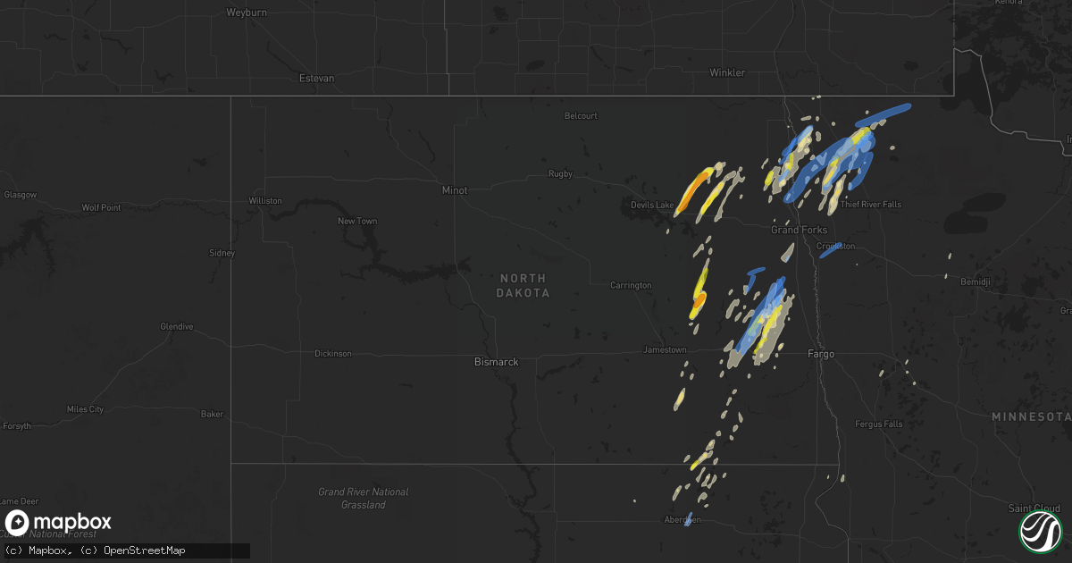
Hail Map in North Dakota on June 17, 2020
Get this storm
June 17 map
$229
one time, instant access
Download today. No call, no setup
Keep the $229
Bought the map and want the full workflow? Apply the entire $229 to a subscription within 7 days. None of it is wasted.
Every map, not just this one
This buys you this map. Subscription and you get every map we run, in the markets you choose from a few cities to whole states to nationwide. Plus real-time alerts the moment a storm fires.
Contact data
Name, contact info, occupancy, even credit band for addresses in the footprint. You go from where it hit to who to call.
Become the source they trust
Unlimited branding weather history reports on demand. You already have the documented answer ready for the property owner, and you are the one who showed up with it.
Property data and RoofTrace estimates
Pull up any address you have got, its value and the exact code rules for that jurisdiction, straight from One Click Code. Then RoofTrace estimates the squares, pitch, and roof value, priced the way you price.
Storm reports in North Dakota
North Dakota
| Date | Description |
|---|---|
| 06/17/20206:52 PM CDT | Numerous poplar trees snapped in shelter belts along interstate 29 from near the alexander henry rest area... Near mp179 to mp184. Time estimated between 652 pm cdt and |
| 06/17/20206:48 PM CDT | Picture of hail stone - time estimated based on radar. |
| 06/17/20206:44 PM CDT | Peak wind measured at an ndawn station. |
| 06/17/20206:43 PM CDT | Relayed photo on social media |
| 06/17/20206:35 PM CDT | A local report indicates 1.50 inch wind near 5 S ADAMS |
| 06/17/20206:20 PM CDT | Relayed photo on social media |
| 06/17/20205:56 PM CDT | Large hail noted along highway 2... About a mile west of the racetrack. Time estimated based on radar. |
| 06/17/20207:49 AM CDT | At 1248 AM CDT, severe thunderstorms were located along a line extending from 7 miles southeast of Greene to 4 miles west of Glenburn to near Deering, moving northeast at 60 mph. HAZARD...60 mph wind gusts and penny size hail. SOURCE...Trained weather spotters. IMPACT...Expect damage to roofs, siding, and trees. Severe thunderstorms will be near... Mohall and Maxbass around 105 AM CDT. Newburg around 110 AM CDT. Westhope and Antler around 120 AM CDT. Souris around 125 AM CDT. Lake Metigoshe State Park around 140 AM CDT.Other locations impacted by these severe thunderstorms includeCarbury, Russell, Roth, Loraine, Landa, Grano, Eckman and Kramer. |
| 06/17/20207:09 AM CDT | At 1208 AM CDT, severe thunderstorms were located along a line extending from 7 miles north of Parshall to 4 miles north of Makoti to 6 miles northwest of Max, moving northeast at 55 mph. HAZARD...60 mph wind gusts and penny size hail. SOURCE...Radar indicated. IMPACT...Expect damage to roofs, siding, and trees. Severe thunderstorms will be near... Berthold, Des Lacs and Blaisdell around 1230 AM CDT. Minot, Burlington and Foxholm around 1235 AM CDT. Surrey around 1240 AM CDT. Minot Air Force Base and Donnybrook around 1245 AM CDT.Other locations impacted by these severe thunderstorms includeHartland, Logan, Coulee, and Tagus. |
| 06/17/20204:25 AM CDT | At 924 PM CDT, a severe thunderstorm was located near Hecla, or 16 miles south of Oakes, moving northeast at 25 mph. HAZARD...60 mph wind gusts. SOURCE...Radar indicated. IMPACT...Expect damage to roofs, siding, and trees. This severe thunderstorm will be near... Ludden around 935 PM CDT. |
| 06/17/20204:19 AM CDT | At 918 PM CDT, severe thunderstorms were located along a line extending from Poland to near Crookston, moving northeast at 55 mph. HAZARD...70 mph wind gusts and penny size hail. SOURCE...Radar indicated. IMPACT...Expect considerable tree damage. Damage is likely to mobile homes, roofs, and outbuildings. Severe thunderstorms will be near... Crookston around 920 PM CDT. Euclid and Huot around 930 PM CDT. Dorothy around 935 PM CDT. Wylie and Argyle around 940 PM CDT. Stephen, St. Hilaire and Carpenters Corner around 945 PM CDT.Other locations impacted by these severe thunderstorms include ThiefRiver Falls Airport.This includes Interstate 29 between mile markers 142 and 159. |
| 06/17/20203:39 AM CDT | At 839 PM CDT, severe thunderstorms were located along a line extending from near Warren to near Caledonia, moving northeast at 40 mph. HAZARD...70 mph wind gusts and penny size hail. SOURCE...Radar indicated. IMPACT...Expect considerable tree damage. Damage is likely to mobile homes, roofs, and outbuildings. Locations impacted include... Thief River Falls, Crookston, Red Lake Falls, Halstad, Fisher, Newfolden and Middle River. |
| 06/17/20203:33 AM CDT | At 833 PM CDT, a severe thunderstorm was located near Ayr, or 21 miles east of Valley City, moving northeast at 35 mph. HAZARD...60 mph wind gusts and nickel size hail. SOURCE...Radar indicated. IMPACT...Expect damage to roofs, siding, and trees. Locations impacted include... Hunter, Page, Galesburg, Erie, Blanchard, Clifford and Ayr. |
| 06/17/20203:26 AM CDT | At 826 PM CDT, severe thunderstorms were located along a line extending from 14 miles north of Caribou to near Leo to near Radium, moving northeast at 40 mph. HAZARD...70 mph wind gusts and penny size hail. SOURCE...Radar indicated. IMPACT...Expect considerable tree damage. Damage is likely to mobile homes, roofs, and outbuildings. Locations impacted include... Hallock, Karlstad, Greenbush, Stephen, Argyle, Badger and Lancaster. |
| 06/17/20203:20 AM CDT | At 820 PM CDT, a severe thunderstorm was located near Houghton, or 15 miles north of Groton, moving northeast at 30 mph. HAZARD...60 mph wind gusts and quarter size hail. SOURCE...Radar indicated. IMPACT...Hail damage to vehicles is expected. Expect wind damage to roofs, siding, and trees. Locations impacted include... Britton, Hecla, Claremont, Sand Lake Wildlife Refuge, Amherst and Houghton. |
| 06/17/20202:43 AM CDT | At 742 PM CDT, severe thunderstorms were located along a line extending from near St. Vincent to 6 miles northeast of Donaldson, moving northeast at 40 mph. HAZARD...60 mph wind gusts and quarter size hail. SOURCE...Trained weather spotters reported downed trees near Robin Minnesota. IMPACT...Hail damage to vehicles is expected. Expect wind damage to roofs, siding, and trees. Locations impacted include... Hallock, Drayton, Stephen, Lancaster, Lake Bronson, Kennedy and Warsaw.This includes Interstate 29 between mile markers 166 and 202. |
| 06/17/20202:39 AM CDT | At 738 PM CDT, severe thunderstorms were located along a line extending from near Manvel to near Grand Forks to Clifford, moving northeast at 55 mph. HAZARD...70 mph wind gusts and quarter size hail. SOURCE...Trained weather spotters reported damage near Golden Lake. IMPACT...Hail damage to vehicles is expected. Expect considerable tree damage. Wind damage is also likely to mobile homes, roofs, and outbuildings. Severe thunderstorms will be near... Manvel, East Grand Forks and Grand Forks around 740 PM CDT. Poland around 745 PM CDT. Oslo and Mayville around 750 PM CDT. Tabor, Alvarado and Big Woods around 755 PM CDT. March around 800 PM CDT.Other locations impacted by these severe thunderstorms include GrandForks Airport.This includes Interstate 29 between mile markers 118 and 168. |
| 06/17/20202:17 AM CDT | At 717 PM CDT, a severe thunderstorm was located near Oriska, or 12 miles east of Valley City, moving northeast at 40 mph. HAZARD...60 mph wind gusts and quarter size hail. SOURCE...Radar indicated. IMPACT...Hail damage to vehicles is expected. Expect wind damage to roofs, siding, and trees. Locations impacted include... Arthur, Hunter, Tower City, Page, Buffalo, Grandin and Oriska. This includes the following highways... Interstate 29 between mile markers 92 and 98. Interstate 94 in North Dakota between mile markers 293 and 318. |
| 06/17/20202:03 AM CDT | At 703 PM CDT, a severe thunderstorm was located near Sherbrooke, or 37 miles northeast of Valley City, moving northeast at 55 mph. HAZARD...60 mph wind gusts and quarter size hail. SOURCE...Radar indicated. IMPACT...Hail damage to vehicles is expected. Expect wind damage to roofs, siding, and trees. Locations impacted include... Mayville, Thompson, Northwood, Hatton, Portland, Golden Lake and Reynolds.This includes Interstate 29 between mile markers 125 and 129. |
| 06/17/20201:45 AM CDT | At 645 PM CDT, a severe thunderstorm was located over Drayton, or 15 miles northeast of Grafton, moving north at 35 mph. HAZARD...60 mph wind gusts and quarter size hail. SOURCE...Radar indicated. IMPACT...Hail damage to vehicles is expected. Expect wind damage to roofs, siding, and trees. Locations impacted include... Hallock, Drayton, Pembina, Lancaster, Kennedy, Oakwood and St. Vincent.This includes Interstate 29 between mile markers 168 and 214, andbetween mile markers 216 and 217. |
| 06/17/20201:38 AM CDT | At 637 PM CDT, a severe thunderstorm was located near Adams, or 29 miles south of Langdon, moving northeast at 40 mph. This storm has a history of producing large hail. HAZARD...Two inch hail and 70 mph wind gusts. SOURCE...Radar indicated. IMPACT...People and animals outdoors will be injured. Expect hail damage to roofs, siding, windows, and vehicles. Expect considerable tree damage. Wind damage is also likely to mobile homes, roofs, and outbuildings. Locations impacted include... Hoople, Edinburg, Crystal, Adams, Mountain, Hensel and Akra. |
| 06/17/20201:35 AM CDT | Of several storms that came through during the late evening this storm produced the most extensive branch damage. Some broken branches were up to 12 inches in diameter. |
| 06/17/20201:35 AM CDT | Several rounds of storms through the evening into the overnight. The last round between 1:30am and 2:00am downed the majority of tree branches... Some 12 inches in diam |
| 06/17/20201:34 AM CDT | At 633 PM CDT, a severe thunderstorm was located near Mapes, or 32 miles east of Devils Lake, moving northeast at 45 mph. HAZARD...Ping pong ball size hail and 60 mph wind gusts. SOURCE...Radar indicated. IMPACT...People and animals outdoors will be injured. Expect hail damage to roofs, siding, windows, and vehicles. Expect wind damage to roofs, siding, and trees. Locations impacted include... Park River, Edinburg, Pisek, Lankin, Whitman, Mapes and Mandt. |
| 06/17/20201:24 AM CDT | A local report indicates 62 MPH wind near 4 SSW GALESBURG |
| 06/17/20201:10 AM CDT | At 610 PM CDT, a severe thunderstorm was located near Dazey, or 26 miles northwest of Valley City, moving northeast at 35 mph. HAZARD...70 mph wind gusts and quarter size hail. SOURCE...Radar indicated. IMPACT...Hail damage to vehicles is expected. Expect considerable tree damage. Wind damage is also likely to mobile homes, roofs, and outbuildings. Locations impacted include... Cooperstown, Hannaford, Dazey, Sharon, Jessie, Leal and Walum. |
| 06/17/20201:00 AM CDT | At 600 PM CDT, a severe thunderstorm was located over Dickey, or 15 miles northeast of Edgeley, moving northeast at 35 mph. HAZARD...60 mph wind gusts and quarter size hail. SOURCE...Radar indicated. IMPACT...Hail damage to vehicles is expected. Expect wind damage to roofs, siding, and trees. This severe thunderstorm will be near... Adrian around 610 PM CDT. Marion around 620 PM CDT.Other locations impacted by this severe thunderstorm include GrandRapids. |
| 06/17/202012:53 AM CDT | At 553 PM CDT, a severe thunderstorm was located over Doyon, or 16 miles east of Devils Lake, moving northeast at 40 mph. HAZARD...70 mph wind gusts and ping pong ball size hail. SOURCE...Radar indicated. IMPACT...People and animals outdoors will be injured. Expect hail damage to roofs, siding, windows, and vehicles. Expect considerable tree damage. Wind damage is also likely to mobile homes, roofs, and outbuildings. Locations impacted include... Edmore, Crary, Adams, Doyon, Brocket, Lawton and Southam. |
| 06/16/202010:35 PM CDT | Awning twisted at the caseys general store and gas station. Time estimated based on radar. |
| 06/16/20209:35 PM CDT | Mping report with 3 inch tree limbs broken. Power poles broken. |
| 06/16/20209:14 PM CDT | Large hail fell for a few minutes... Through 917 pm cdt. |
| 06/16/20209:05 PM CDT | Several rounds of storms came through during the late evening. Some 3-4 inch diameter branches broke down with this storm. |
| 06/16/20208:59 PM CDT | A local report indicates 1.00 inch wind near 4 NW WHEATLAND |
| 06/16/20208:54 PM CDT | Damage to shelter belt - time estimated by radar. |
| 06/16/20208:48 PM CDT | Large hail from quarter to ping pong ball sized. |
| 06/16/20208:38 PM CDT | A local report indicates 66 MPH wind near 4 SSE BUXTON |
| 06/16/20208:32 PM CDT | At 132 AM CDT, severe thunderstorms were located along a line extending from 10 miles south of Regan to 11 miles southwest of Tuttle, moving northeast at 55 mph. HAZARD...60 mph wind gusts and quarter size hail. SOURCE...Radar indicated. IMPACT...Hail damage to vehicles is expected. Expect wind damage to roofs, siding, and trees. Severe thunderstorms will be near... Wing, Tuttle and Regan around 145 AM CDT.Other locations impacted by these severe thunderstorms include Arena. |
| 06/16/20208:31 PM CDT | Peak wind measured at an rwis station from 831 pm cdt through 838 pm cdt. |
| 06/16/20208:14 PM CDT | Peak wind measured at a personal weather station. |
| 06/16/20207:56 PM CDT | A local report indicates 69 MPH wind near GRAND FORKS AFB |
| 06/16/20207:46 PM CDT | Peak wind measured at an ndawn station. |
| 06/16/20207:45 PM CDT | Tree damaged reported from multiple sources. |
| 06/16/20207:35 PM CDT | A couple of trees down in town. Time estimated based on radar. |
| 06/16/20207:31 PM CDT | Peak wind measured at an ndawn station. |
| 06/16/20207:29 PM CDT | Mulitple boats... Pontoons... And sections of boat docks flipped on golden lake. Several large trees snapped or uprooted on the east side of the lake. Section of roofin |
| 06/16/20207:29 PM CDT | Mulitple boats flipped on golden lake. |
| 06/16/20207:25 PM CDT | Semi trailer blown off i94 near oriska. Also reported a boat blowing off trailer. |
All States Impacted by Hail Map on June 17, 2020
Cities Impacted by Hail Map on June 17, 2020
- Karlstad, MN
- Strandquist, MN
- Greenbush, MN
- Buffalo, ND
- Tower City, ND
- Lamesa, TX
- Odonnell, TX
- Shallowater, TX
- Lubbock, TX
- Strathcona, MN
- Abernathy, TX
- Murdo, SD
- Grafton, ND
- Hallock, MN
- Kennedy, MN
- Presho, SD
- Kennebec, SD
- Draper, SD
- Vivian, SD
- Lower Brule, SD
- Levelland, TX
- Anton, TX
- Hale Center, TX
- Olton, TX
- Littlefield, TX
- Kilgore, NE
- Crookston, NE
- Cody, NE
- Valentine, NE
- Tahoka, TX
- Wilson, TX
- Saint Lawrence, SD
- Stephen, MN
- Page, ND
- Erie, ND
- Galesburg, ND
- Fort Stockton, TX
- Wheatland, ND
- White River, SD
- Frazee, MN
- Oacoma, SD
- Lakota, ND
- Lankin, ND
- Michigan, ND
- Park River, ND
- Lewellen, NE
- Oshkosh, NE
- Seagraves, TX
- Alvarado, MN
- Wessington, SD
- Miller, SD
- Stirum, ND
- Meadow, TX
- Ropesville, TX
- Groton, SD
- Dryden, TX
- Saint Francis, SD
- Plainview, TX
- Kress, TX
- Viking, MN
- Warren, MN
- Amherst, TX
- Sudan, TX
- Mission, SD
- Oakes, ND
- Lorenzo, TX
- Idalou, TX
- Hatton, ND
- Reynolds, ND
- Thompson, ND
- Brownfield, TX
- Sundown, TX
- Hope, ND
- Houghton, SD
- Hecla, SD
- Earth, TX
- Imperial, TX
- Brocket, ND
- Lawton, ND
- Virgil, SD
- Alpena, SD
- Wessington Springs, SD
- Ypsilanti, ND
- Petersburg, TX
- Dickey, ND
- Berlin, ND
- Edgeley, ND
- Argyle, MN
- Muleshoe, TX
- Gail, TX
- Hyannis, NE
- Merriman, NE
- Whitman, NE
- Marathon, TX
- Hartington, NE
- Fordyce, NE
- Sparks, NE
- Springview, NE
- Crary, ND
- Adams, ND
- Blanchard, ND
- Pep, TX
- Fordville, ND
- Gregory, SD
- Dallas, SD
- Minto, ND
- Newfolden, MN
- Wheaton, MN
- Justiceburg, TX
- Fluvanna, TX
- Crystal City, TX
- Randolph, NE
- Coleridge, NE
- Winner, SD
- Seminole, TX
- Lancaster, MN
- Cooperstown, ND
- Wimbledon, ND
- Dazey, ND
- Hannaford, ND
- Welch, TX
- Laurel, NE
- Belden, NE
- Valley City, ND
- Mekinock, ND
- Wolsey, SD
- Alliance, NE
- Westport, SD
- Verona, ND
- Fort Ransom, ND
- Wood, SD
- New Deal, TX
- Coyanosa, TX
- Frederick, SD
- Lake Bronson, MN
- Thedford, NE
- Finley, ND
- Drayton, ND
- Grandfalls, TX
- Gilby, ND
- Grand Forks, ND
- Sanderson, TX
- Columbia, SD
- Oriska, ND
- Kathryn, ND
- Post, TX
- Middle River, MN
- Perham, MN
- Loop, TX
- Ayr, ND
- Hunter, ND
- Manvel, ND
- Luverne, ND
- Beltrami, MN
- Barnard, SD
- Tulare, SD
- Clifford, ND
- Rosholt, SD
- East Grand Forks, MN
- Binford, ND
- Hemingford, NE
- Lisbon, ND
- Nome, ND
- Ellendale, ND
- Chamberlain, SD
- Norris, SD
- Okaton, SD
- Aneta, ND
- Jessie, ND
- Enderlin, ND
- Pelican Rapids, MN
- Detroit Lakes, MN
- Audubon, MN
- Pillsbury, ND
- Cogswell, ND
- Colome, SD
- Ashby, NE
- Badger, MN
- Amenia, ND
- Arthur, ND
- Warwick, ND
- Hillsboro, ND
- Euclid, MN
- Forest River, ND
- Donaldson, MN
- Absaraka, ND
- Fingal, ND
- Leola, SD
- Wynot, NE
- Harrold, SD
- Mcville, ND
- Pukwana, SD
- Carroll, NE
- Winside, NE
- Marion, ND
- Arthur, NE
- Dimmitt, TX
- Johnstown, NE
- Carrizo Springs, TX
- Edinburg, ND
- Hoskins, NE
- Pekin, ND
- Pisek, ND
- Dahlen, ND
- Petersburg, ND
- Wood Lake, NE
- Leonard, MN
- Snyder, TX
- Rogers, ND
- Sanborn, ND
- Shevlin, MN
- Fort Pierre, SD
- Ralls, TX
- Tulia, TX
- Slaton, TX
- Crosbyton, TX
- Portland, ND
- Mayville, ND
- Oslo, MN
- Climax, MN
- Crookston, MN
- Roseau, MN
- Aberdeen, SD
- Henry, SD
- Watertown, SD
- Hazel, SD


