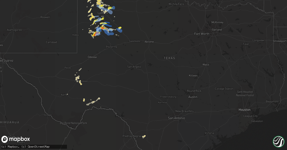
Hail Map in Texas on June 17, 2020
Get this storm
June 17 map
$229
one time, instant access
Download today. No call, no setup
Keep the $229
Bought the map and want the full workflow? Apply the entire $229 to a subscription within 7 days. None of it is wasted.
Every map, not just this one
This buys you this map. Subscription and you get every map we run, in the markets you choose from a few cities to whole states to nationwide. Plus real-time alerts the moment a storm fires.
Contact data
Name, contact info, occupancy, even credit band for addresses in the footprint. You go from where it hit to who to call.
Become the source they trust
Unlimited branding weather history reports on demand. You already have the documented answer ready for the property owner, and you are the one who showed up with it.
Property data and RoofTrace estimates
Pull up any address you have got, its value and the exact code rules for that jurisdiction, straight from One Click Code. Then RoofTrace estimates the squares, pitch, and roof value, priced the way you price.
Storm reports in Texas
Texas
| Date | Description |
|---|---|
| 06/17/20206:45 PM CDT | West texas mesonet |
| 06/17/20204:56 PM CDT | West texas mesonet |
| 06/17/20204:43 AM CDT | At 943 PM CDT, a severe thunderstorm was located near Lake Alan Henry, moving east at 15 mph. HAZARD...60 mph wind gusts and penny size hail. SOURCE...Radar indicated. IMPACT...Expect damage to roofs, siding, and trees. Locations impacted include... Lake Alan Henry. |
| 06/17/20204:27 AM CDT | At 927 PM CDT, severe thunderstorms were located along a line extending from 6 miles southeast of Lake Alan Henry to Gail to near Lamesa, moving southeast at 20 mph. HAZARD...70 mph wind gusts and nickel size hail. SOURCE...Radar indicated. IMPACT...Expect considerable tree damage. Damage is likely to mobile homes, roofs, and outbuildings. Locations impacted include... Snyder, Lamesa, Gail, Fluvanna, J B Thomas Reservoir, Lamesa Municipal Airport, Los Ybanez, Sparenberg, Randalls Corner, Punkin Center, Arvana, Winston Field, Hancock, Knapp and Key. |
| 06/17/20203:49 AM CDT | At 849 PM CDT, a severe thunderstorm was located 7 miles east of O'donnell, or 15 miles south of Tahoka, moving southeast at 25 mph. HAZARD...70 mph wind gusts and quarter size hail. SOURCE...Radar indicated. IMPACT...Hail damage to vehicles is expected. Expect considerable tree damage. Wind damage is also likely to mobile homes, roofs, and outbuildings. Locations impacted include... Gail, Fluvanna, Hancock and Key. |
| 06/17/20203:31 AM CDT | At 831 PM CDT, a severe thunderstorm was located 4 miles south of Tahoka, moving east at 35 mph. HAZARD...70 mph wind gusts and penny size hail. SOURCE...Radar indicated. IMPACT...Expect considerable tree damage. Damage is likely to mobile homes, roofs, and outbuildings. Locations impacted include... Post, Tahoka, O'donnell and Grassland. |
| 06/17/20203:11 AM CDT | At 811 PM CDT, a severe thunderstorm was located 12 miles south of Welch, or 13 miles west of Lamesa, moving northeast at 25 mph. HAZARD...60 mph wind gusts and quarter size hail. SOURCE...Radar indicated. IMPACT...Hail damage to vehicles is expected. Expect wind damage to roofs, siding, and trees. Locations impacted include... Lamesa, Welch, Lamesa Municipal Airport, Punkin Center, Arvana, Hancock and McKenzie Lake. |
| 06/17/20202:50 AM CDT | At 750 PM CDT, a severe thunderstorm was located near Lubbock International Airport, or 9 miles northeast of Lubbock, moving east at 30 mph. HAZARD...70 mph wind gusts and penny size hail. SOURCE...Radar indicated. IMPACT...Expect considerable tree damage. Damage is likely to mobile homes, roofs, and outbuildings. Locations impacted include... Lubbock, Idalou, Ralls, Lorenzo, Lubbock International Airport and New Deal. |
| 06/17/20202:44 AM CDT | At 744 PM CDT, a severe thunderstorm was located 8 miles west of Tahoka, moving northeast at 35 mph. HAZARD...70 mph wind gusts and penny size hail. SOURCE...Radar indicated. IMPACT...Expect considerable tree damage. Damage is likely to mobile homes, roofs, and outbuildings. Locations impacted include... Tahoka and Wilson. |
| 06/17/20202:25 AM CDT | At 725 PM CDT, a severe thunderstorm was located 7 miles southeast of Slide, or 11 miles north of Tahoka, moving east at 30 mph. HAZARD...60 mph wind gusts and penny size hail. SOURCE...Radar indicated. IMPACT...Expect damage to roofs, siding, and trees. Locations impacted include... Slaton, Wilson and New Home. |
| 06/17/20202:20 AM CDT | At 720 PM CDT, a severe thunderstorm was located 4 miles west of Lubbock International Airport, or 6 miles north of Lubbock, moving east at 30 mph. HAZARD...60 mph wind gusts and penny size hail. SOURCE...Radar indicated. IMPACT...Expect damage to roofs, siding, and trees. Locations impacted include... Lubbock, Idalou, Lubbock International Airport and New Deal. |
| 06/17/20201:58 AM CDT | At 658 PM CDT, a severe thunderstorm was located over Abernathy, moving east at 40 mph. HAZARD...60 mph wind gusts and quarter size hail. SOURCE...Radar indicated. IMPACT...Hail damage to vehicles is expected. Expect wind damage to roofs, siding, and trees. Locations impacted include... Abernathy, Petersburg and New Deal. |
| 06/17/20201:55 AM CDT | At 655 PM CDT, a severe thunderstorm was located 5 miles west of Kress, or 10 miles south of Tulia, moving northeast at 25 mph. HAZARD...60 mph wind gusts and quarter size hail. SOURCE...Radar indicated. IMPACT...Hail damage to vehicles is expected. Expect wind damage to roofs, siding, and trees. Locations impacted include... Tulia, Kress and Mackenzie Reservoir. |
| 06/17/20201:46 AM CDT | At 646 PM CDT, a severe thunderstorm was located over Brownfield, moving northeast at 30 mph. HAZARD...60 mph wind gusts and penny size hail. SOURCE...Radar indicated. IMPACT...Expect damage to roofs, siding, and trees. Locations impacted include... Brownfield and Meadow. |
| 06/17/20201:06 AM CDT | At 605 PM CDT, a severe thunderstorm was located 7 miles northwest of Cotton Center, or 8 miles south of Olton, moving northeast at 20 mph. HAZARD...60 mph wind gusts and penny size hail. SOURCE...Radar indicated. IMPACT...Expect damage to roofs, siding, and trees. Locations impacted include... Hale Center, Olton, Cotton Center and Halfway. |
| 06/17/202012:11 AM CDT | At 511 PM CDT, severe thunderstorms were located along a line extending from 3 miles northwest of Earth to 9 miles northeast of Tokio, moving east at 40 mph. HAZARD...70 mph wind gusts and penny size hail. SOURCE...Radar indicated. IMPACT...Expect considerable tree damage. Damage is likely to mobile homes, roofs, and outbuildings. Locations impacted include... Levelland, Littlefield, Olton, Earth, Anton, Sudan, Amherst, Fieldton, Spade, Whitharral, Pep, Smyer, Whiteface, Ropesville, Opdyke West and Springlake. |
| 06/16/202010:24 PM CDT | At 324 PM CDT, a severe thunderstorm was located over Fort Stockton, moving north at 10 mph. HAZARD...60 mph wind gusts and quarter size hail. SOURCE...Radar indicated. IMPACT...Hail damage to vehicles is expected. Expect wind damage to roofs, siding, and trees. Locations impacted include... Fort Stockton, Fort Stockton-Pecos County Airport and Firestone Test Track.This includes Interstate 10 between mile markers 244 and 272. |
| 06/16/20208:55 PM CDT | A local report indicates 58 MPH wind near 2 SE LAMESA |
| 06/16/20208:39 PM CDT | A local report indicates 75 MPH wind near WELCH |
| 06/16/20208:29 PM CDT | A local report indicates 62 MPH wind near WELCH |
| 06/16/20208:20 PM CDT | West texas mesonet |
| 06/16/20207:42 PM CDT | West texas mesonet |
| 06/16/20207:20 PM CDT | West texas mesonet |
| 06/16/20207:02 PM CDT | Multiple powerlines down. Extensive damage to mobile home. |
All States Impacted by Hail Map on June 17, 2020
Cities Impacted by Hail Map on June 17, 2020
- Karlstad, MN
- Strandquist, MN
- Greenbush, MN
- Buffalo, ND
- Tower City, ND
- Lamesa, TX
- Odonnell, TX
- Shallowater, TX
- Lubbock, TX
- Strathcona, MN
- Abernathy, TX
- Murdo, SD
- Grafton, ND
- Hallock, MN
- Kennedy, MN
- Presho, SD
- Kennebec, SD
- Draper, SD
- Vivian, SD
- Lower Brule, SD
- Levelland, TX
- Anton, TX
- Hale Center, TX
- Olton, TX
- Littlefield, TX
- Kilgore, NE
- Crookston, NE
- Cody, NE
- Valentine, NE
- Tahoka, TX
- Wilson, TX
- Saint Lawrence, SD
- Stephen, MN
- Page, ND
- Erie, ND
- Galesburg, ND
- Fort Stockton, TX
- Wheatland, ND
- White River, SD
- Frazee, MN
- Oacoma, SD
- Lakota, ND
- Lankin, ND
- Michigan, ND
- Park River, ND
- Lewellen, NE
- Oshkosh, NE
- Seagraves, TX
- Alvarado, MN
- Wessington, SD
- Miller, SD
- Stirum, ND
- Meadow, TX
- Ropesville, TX
- Groton, SD
- Dryden, TX
- Saint Francis, SD
- Plainview, TX
- Kress, TX
- Viking, MN
- Warren, MN
- Amherst, TX
- Sudan, TX
- Mission, SD
- Oakes, ND
- Lorenzo, TX
- Idalou, TX
- Hatton, ND
- Reynolds, ND
- Thompson, ND
- Brownfield, TX
- Sundown, TX
- Hope, ND
- Houghton, SD
- Hecla, SD
- Earth, TX
- Imperial, TX
- Brocket, ND
- Lawton, ND
- Virgil, SD
- Alpena, SD
- Wessington Springs, SD
- Ypsilanti, ND
- Petersburg, TX
- Dickey, ND
- Berlin, ND
- Edgeley, ND
- Argyle, MN
- Muleshoe, TX
- Gail, TX
- Hyannis, NE
- Merriman, NE
- Whitman, NE
- Marathon, TX
- Hartington, NE
- Fordyce, NE
- Sparks, NE
- Springview, NE
- Crary, ND
- Adams, ND
- Blanchard, ND
- Pep, TX
- Fordville, ND
- Gregory, SD
- Dallas, SD
- Minto, ND
- Newfolden, MN
- Wheaton, MN
- Justiceburg, TX
- Fluvanna, TX
- Crystal City, TX
- Randolph, NE
- Coleridge, NE
- Winner, SD
- Seminole, TX
- Lancaster, MN
- Cooperstown, ND
- Wimbledon, ND
- Dazey, ND
- Hannaford, ND
- Welch, TX
- Laurel, NE
- Belden, NE
- Valley City, ND
- Mekinock, ND
- Wolsey, SD
- Alliance, NE
- Westport, SD
- Verona, ND
- Fort Ransom, ND
- Wood, SD
- New Deal, TX
- Coyanosa, TX
- Frederick, SD
- Lake Bronson, MN
- Thedford, NE
- Finley, ND
- Drayton, ND
- Grandfalls, TX
- Gilby, ND
- Grand Forks, ND
- Sanderson, TX
- Columbia, SD
- Oriska, ND
- Kathryn, ND
- Post, TX
- Middle River, MN
- Perham, MN
- Loop, TX
- Ayr, ND
- Hunter, ND
- Manvel, ND
- Luverne, ND
- Beltrami, MN
- Barnard, SD
- Tulare, SD
- Clifford, ND
- Rosholt, SD
- East Grand Forks, MN
- Binford, ND
- Hemingford, NE
- Lisbon, ND
- Nome, ND
- Ellendale, ND
- Chamberlain, SD
- Norris, SD
- Okaton, SD
- Aneta, ND
- Jessie, ND
- Enderlin, ND
- Pelican Rapids, MN
- Detroit Lakes, MN
- Audubon, MN
- Pillsbury, ND
- Cogswell, ND
- Colome, SD
- Ashby, NE
- Badger, MN
- Amenia, ND
- Arthur, ND
- Warwick, ND
- Hillsboro, ND
- Euclid, MN
- Forest River, ND
- Donaldson, MN
- Absaraka, ND
- Fingal, ND
- Leola, SD
- Wynot, NE
- Harrold, SD
- Mcville, ND
- Pukwana, SD
- Carroll, NE
- Winside, NE
- Marion, ND
- Arthur, NE
- Dimmitt, TX
- Johnstown, NE
- Carrizo Springs, TX
- Edinburg, ND
- Hoskins, NE
- Pekin, ND
- Pisek, ND
- Dahlen, ND
- Petersburg, ND
- Wood Lake, NE
- Leonard, MN
- Snyder, TX
- Rogers, ND
- Sanborn, ND
- Shevlin, MN
- Fort Pierre, SD
- Ralls, TX
- Tulia, TX
- Slaton, TX
- Crosbyton, TX
- Portland, ND
- Mayville, ND
- Oslo, MN
- Climax, MN
- Crookston, MN
- Roseau, MN
- Aberdeen, SD
- Henry, SD
- Watertown, SD
- Hazel, SD


