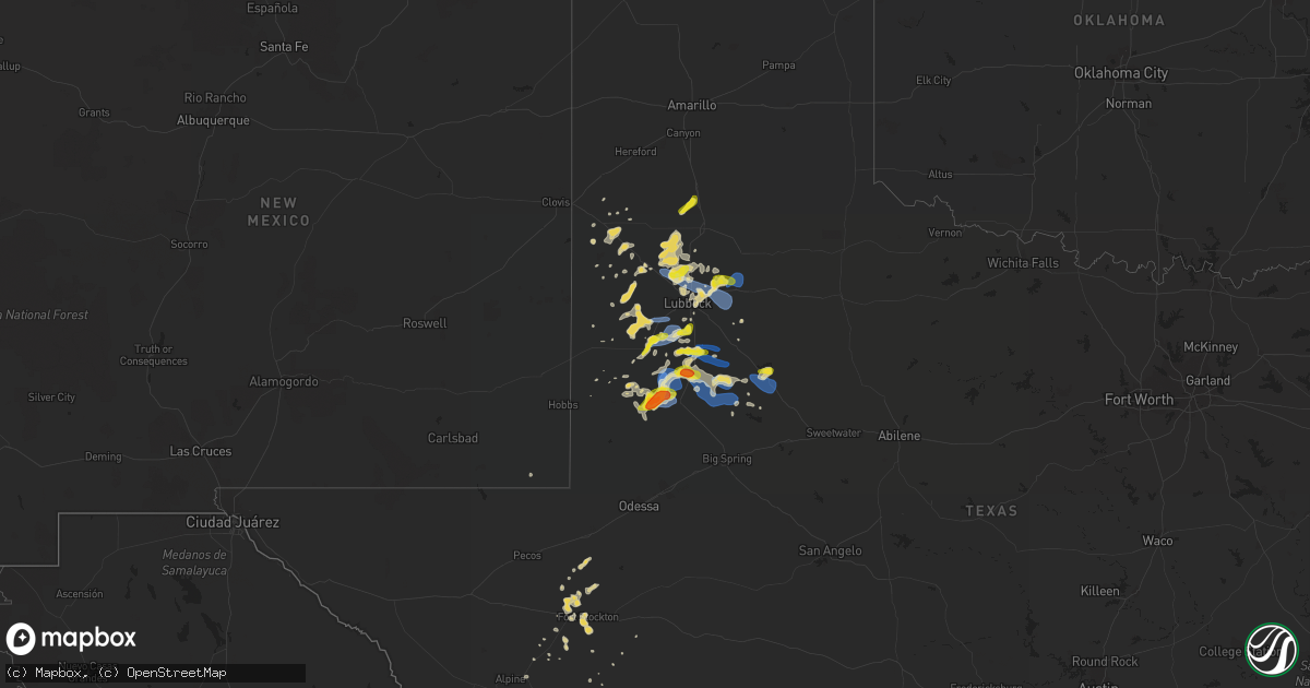
Hail Map on June 17, 2020
Get this storm
June 17 map
$229
one time, instant access
Download today. No call, no setup
Keep the $229
Bought the map and want the full workflow? Apply the entire $229 to a subscription within 7 days. None of it is wasted.
Every map, not just this one
This buys you this map. Subscription and you get every map we run, in the markets you choose from a few cities to whole states to nationwide. Plus real-time alerts the moment a storm fires.
Contact data
Name, contact info, occupancy, even credit band for addresses in the footprint. You go from where it hit to who to call.
Become the source they trust
Unlimited branding weather history reports on demand. You already have the documented answer ready for the property owner, and you are the one who showed up with it.
Property data and RoofTrace estimates
Pull up any address you have got, its value and the exact code rules for that jurisdiction, straight from One Click Code. Then RoofTrace estimates the squares, pitch, and roof value, priced the way you price.
States Impacted by Hail Map on June 17, 2020
Storm reports
North Dakota
| Date | Description |
|---|---|
| 06/17/20206:52 PM CDT | Numerous poplar trees snapped in shelter belts along interstate 29 from near the alexander henry rest area... Near mp179 to mp184. Time estimated between 652 pm cdt and |
| 06/17/20206:48 PM CDT | Picture of hail stone - time estimated based on radar. |
| 06/17/20206:44 PM CDT | Peak wind measured at an ndawn station. |
| 06/17/20206:43 PM CDT | Relayed photo on social media |
| 06/17/20206:35 PM CDT | A local report indicates 1.50 inch wind near 5 S ADAMS |
| 06/17/20206:20 PM CDT | Relayed photo on social media |
| 06/17/20205:56 PM CDT | Large hail noted along highway 2... About a mile west of the racetrack. Time estimated based on radar. |
| 06/17/20207:49 AM CDT | At 1248 AM CDT, severe thunderstorms were located along a line extending from 7 miles southeast of Greene to 4 miles west of Glenburn to near Deering, moving northeast at 60 mph. HAZARD...60 mph wind gusts and penny size hail. SOURCE...Trained weather spotters. IMPACT...Expect damage to roofs, siding, and trees. Severe thunderstorms will be near... Mohall and Maxbass around 105 AM CDT. Newburg around 110 AM CDT. Westhope and Antler around 120 AM CDT. Souris around 125 AM CDT. Lake Metigoshe State Park around 140 AM CDT.Other locations impacted by these severe thunderstorms includeCarbury, Russell, Roth, Loraine, Landa, Grano, Eckman and Kramer. |
| 06/17/20207:09 AM CDT | At 1208 AM CDT, severe thunderstorms were located along a line extending from 7 miles north of Parshall to 4 miles north of Makoti to 6 miles northwest of Max, moving northeast at 55 mph. HAZARD...60 mph wind gusts and penny size hail. SOURCE...Radar indicated. IMPACT...Expect damage to roofs, siding, and trees. Severe thunderstorms will be near... Berthold, Des Lacs and Blaisdell around 1230 AM CDT. Minot, Burlington and Foxholm around 1235 AM CDT. Surrey around 1240 AM CDT. Minot Air Force Base and Donnybrook around 1245 AM CDT.Other locations impacted by these severe thunderstorms includeHartland, Logan, Coulee, and Tagus. |
| 06/17/20204:25 AM CDT | At 924 PM CDT, a severe thunderstorm was located near Hecla, or 16 miles south of Oakes, moving northeast at 25 mph. HAZARD...60 mph wind gusts. SOURCE...Radar indicated. IMPACT...Expect damage to roofs, siding, and trees. This severe thunderstorm will be near... Ludden around 935 PM CDT. |
| 06/17/20204:19 AM CDT | At 918 PM CDT, severe thunderstorms were located along a line extending from Poland to near Crookston, moving northeast at 55 mph. HAZARD...70 mph wind gusts and penny size hail. SOURCE...Radar indicated. IMPACT...Expect considerable tree damage. Damage is likely to mobile homes, roofs, and outbuildings. Severe thunderstorms will be near... Crookston around 920 PM CDT. Euclid and Huot around 930 PM CDT. Dorothy around 935 PM CDT. Wylie and Argyle around 940 PM CDT. Stephen, St. Hilaire and Carpenters Corner around 945 PM CDT.Other locations impacted by these severe thunderstorms include ThiefRiver Falls Airport.This includes Interstate 29 between mile markers 142 and 159. |
| 06/17/20203:39 AM CDT | At 839 PM CDT, severe thunderstorms were located along a line extending from near Warren to near Caledonia, moving northeast at 40 mph. HAZARD...70 mph wind gusts and penny size hail. SOURCE...Radar indicated. IMPACT...Expect considerable tree damage. Damage is likely to mobile homes, roofs, and outbuildings. Locations impacted include... Thief River Falls, Crookston, Red Lake Falls, Halstad, Fisher, Newfolden and Middle River. |
| 06/17/20203:33 AM CDT | At 833 PM CDT, a severe thunderstorm was located near Ayr, or 21 miles east of Valley City, moving northeast at 35 mph. HAZARD...60 mph wind gusts and nickel size hail. SOURCE...Radar indicated. IMPACT...Expect damage to roofs, siding, and trees. Locations impacted include... Hunter, Page, Galesburg, Erie, Blanchard, Clifford and Ayr. |
| 06/17/20203:26 AM CDT | At 826 PM CDT, severe thunderstorms were located along a line extending from 14 miles north of Caribou to near Leo to near Radium, moving northeast at 40 mph. HAZARD...70 mph wind gusts and penny size hail. SOURCE...Radar indicated. IMPACT...Expect considerable tree damage. Damage is likely to mobile homes, roofs, and outbuildings. Locations impacted include... Hallock, Karlstad, Greenbush, Stephen, Argyle, Badger and Lancaster. |
| 06/17/20203:20 AM CDT | At 820 PM CDT, a severe thunderstorm was located near Houghton, or 15 miles north of Groton, moving northeast at 30 mph. HAZARD...60 mph wind gusts and quarter size hail. SOURCE...Radar indicated. IMPACT...Hail damage to vehicles is expected. Expect wind damage to roofs, siding, and trees. Locations impacted include... Britton, Hecla, Claremont, Sand Lake Wildlife Refuge, Amherst and Houghton. |
| 06/17/20202:43 AM CDT | At 742 PM CDT, severe thunderstorms were located along a line extending from near St. Vincent to 6 miles northeast of Donaldson, moving northeast at 40 mph. HAZARD...60 mph wind gusts and quarter size hail. SOURCE...Trained weather spotters reported downed trees near Robin Minnesota. IMPACT...Hail damage to vehicles is expected. Expect wind damage to roofs, siding, and trees. Locations impacted include... Hallock, Drayton, Stephen, Lancaster, Lake Bronson, Kennedy and Warsaw.This includes Interstate 29 between mile markers 166 and 202. |
| 06/17/20202:39 AM CDT | At 738 PM CDT, severe thunderstorms were located along a line extending from near Manvel to near Grand Forks to Clifford, moving northeast at 55 mph. HAZARD...70 mph wind gusts and quarter size hail. SOURCE...Trained weather spotters reported damage near Golden Lake. IMPACT...Hail damage to vehicles is expected. Expect considerable tree damage. Wind damage is also likely to mobile homes, roofs, and outbuildings. Severe thunderstorms will be near... Manvel, East Grand Forks and Grand Forks around 740 PM CDT. Poland around 745 PM CDT. Oslo and Mayville around 750 PM CDT. Tabor, Alvarado and Big Woods around 755 PM CDT. March around 800 PM CDT.Other locations impacted by these severe thunderstorms include GrandForks Airport.This includes Interstate 29 between mile markers 118 and 168. |
| 06/17/20202:17 AM CDT | At 717 PM CDT, a severe thunderstorm was located near Oriska, or 12 miles east of Valley City, moving northeast at 40 mph. HAZARD...60 mph wind gusts and quarter size hail. SOURCE...Radar indicated. IMPACT...Hail damage to vehicles is expected. Expect wind damage to roofs, siding, and trees. Locations impacted include... Arthur, Hunter, Tower City, Page, Buffalo, Grandin and Oriska. This includes the following highways... Interstate 29 between mile markers 92 and 98. Interstate 94 in North Dakota between mile markers 293 and 318. |
| 06/17/20202:03 AM CDT | At 703 PM CDT, a severe thunderstorm was located near Sherbrooke, or 37 miles northeast of Valley City, moving northeast at 55 mph. HAZARD...60 mph wind gusts and quarter size hail. SOURCE...Radar indicated. IMPACT...Hail damage to vehicles is expected. Expect wind damage to roofs, siding, and trees. Locations impacted include... Mayville, Thompson, Northwood, Hatton, Portland, Golden Lake and Reynolds.This includes Interstate 29 between mile markers 125 and 129. |
| 06/17/20201:45 AM CDT | At 645 PM CDT, a severe thunderstorm was located over Drayton, or 15 miles northeast of Grafton, moving north at 35 mph. HAZARD...60 mph wind gusts and quarter size hail. SOURCE...Radar indicated. IMPACT...Hail damage to vehicles is expected. Expect wind damage to roofs, siding, and trees. Locations impacted include... Hallock, Drayton, Pembina, Lancaster, Kennedy, Oakwood and St. Vincent.This includes Interstate 29 between mile markers 168 and 214, andbetween mile markers 216 and 217. |
| 06/17/20201:38 AM CDT | At 637 PM CDT, a severe thunderstorm was located near Adams, or 29 miles south of Langdon, moving northeast at 40 mph. This storm has a history of producing large hail. HAZARD...Two inch hail and 70 mph wind gusts. SOURCE...Radar indicated. IMPACT...People and animals outdoors will be injured. Expect hail damage to roofs, siding, windows, and vehicles. Expect considerable tree damage. Wind damage is also likely to mobile homes, roofs, and outbuildings. Locations impacted include... Hoople, Edinburg, Crystal, Adams, Mountain, Hensel and Akra. |
| 06/17/20201:35 AM CDT | Several rounds of storms through the evening into the overnight. The last round between 1:30am and 2:00am downed the majority of tree branches... Some 12 inches in diam |
| 06/17/20201:35 AM CDT | Of several storms that came through during the late evening this storm produced the most extensive branch damage. Some broken branches were up to 12 inches in diameter. |
| 06/17/20201:34 AM CDT | At 633 PM CDT, a severe thunderstorm was located near Mapes, or 32 miles east of Devils Lake, moving northeast at 45 mph. HAZARD...Ping pong ball size hail and 60 mph wind gusts. SOURCE...Radar indicated. IMPACT...People and animals outdoors will be injured. Expect hail damage to roofs, siding, windows, and vehicles. Expect wind damage to roofs, siding, and trees. Locations impacted include... Park River, Edinburg, Pisek, Lankin, Whitman, Mapes and Mandt. |
| 06/17/20201:24 AM CDT | A local report indicates 62 MPH wind near 4 SSW GALESBURG |
| 06/17/20201:10 AM CDT | At 610 PM CDT, a severe thunderstorm was located near Dazey, or 26 miles northwest of Valley City, moving northeast at 35 mph. HAZARD...70 mph wind gusts and quarter size hail. SOURCE...Radar indicated. IMPACT...Hail damage to vehicles is expected. Expect considerable tree damage. Wind damage is also likely to mobile homes, roofs, and outbuildings. Locations impacted include... Cooperstown, Hannaford, Dazey, Sharon, Jessie, Leal and Walum. |
| 06/17/20201:00 AM CDT | At 600 PM CDT, a severe thunderstorm was located over Dickey, or 15 miles northeast of Edgeley, moving northeast at 35 mph. HAZARD...60 mph wind gusts and quarter size hail. SOURCE...Radar indicated. IMPACT...Hail damage to vehicles is expected. Expect wind damage to roofs, siding, and trees. This severe thunderstorm will be near... Adrian around 610 PM CDT. Marion around 620 PM CDT.Other locations impacted by this severe thunderstorm include GrandRapids. |
| 06/17/202012:53 AM CDT | At 553 PM CDT, a severe thunderstorm was located over Doyon, or 16 miles east of Devils Lake, moving northeast at 40 mph. HAZARD...70 mph wind gusts and ping pong ball size hail. SOURCE...Radar indicated. IMPACT...People and animals outdoors will be injured. Expect hail damage to roofs, siding, windows, and vehicles. Expect considerable tree damage. Wind damage is also likely to mobile homes, roofs, and outbuildings. Locations impacted include... Edmore, Crary, Adams, Doyon, Brocket, Lawton and Southam. |
| 06/16/202010:35 PM CDT | Awning twisted at the caseys general store and gas station. Time estimated based on radar. |
| 06/16/20209:35 PM CDT | Mping report with 3 inch tree limbs broken. Power poles broken. |
| 06/16/20209:14 PM CDT | Large hail fell for a few minutes... Through 917 pm cdt. |
| 06/16/20209:05 PM CDT | Several rounds of storms came through during the late evening. Some 3-4 inch diameter branches broke down with this storm. |
| 06/16/20208:59 PM CDT | A local report indicates 1.00 inch wind near 4 NW WHEATLAND |
| 06/16/20208:54 PM CDT | Damage to shelter belt - time estimated by radar. |
| 06/16/20208:48 PM CDT | Large hail from quarter to ping pong ball sized. |
| 06/16/20208:38 PM CDT | A local report indicates 66 MPH wind near 4 SSE BUXTON |
| 06/16/20208:32 PM CDT | At 132 AM CDT, severe thunderstorms were located along a line extending from 10 miles south of Regan to 11 miles southwest of Tuttle, moving northeast at 55 mph. HAZARD...60 mph wind gusts and quarter size hail. SOURCE...Radar indicated. IMPACT...Hail damage to vehicles is expected. Expect wind damage to roofs, siding, and trees. Severe thunderstorms will be near... Wing, Tuttle and Regan around 145 AM CDT.Other locations impacted by these severe thunderstorms include Arena. |
| 06/16/20208:31 PM CDT | Peak wind measured at an rwis station from 831 pm cdt through 838 pm cdt. |
| 06/16/20208:14 PM CDT | Peak wind measured at a personal weather station. |
| 06/16/20207:56 PM CDT | A local report indicates 69 MPH wind near GRAND FORKS AFB |
| 06/16/20207:46 PM CDT | Peak wind measured at an ndawn station. |
| 06/16/20207:45 PM CDT | Tree damaged reported from multiple sources. |
| 06/16/20207:35 PM CDT | A couple of trees down in town. Time estimated based on radar. |
| 06/16/20207:31 PM CDT | Peak wind measured at an ndawn station. |
| 06/16/20207:29 PM CDT | Mulitple boats... Pontoons... And sections of boat docks flipped on golden lake. Several large trees snapped or uprooted on the east side of the lake. Section of roofin |
| 06/16/20207:29 PM CDT | Mulitple boats flipped on golden lake. |
| 06/16/20207:25 PM CDT | Semi trailer blown off i94 near oriska. Also reported a boat blowing off trailer. |
Minnesota
| Date | Description |
|---|---|
| 06/17/20205:44 PM CDT | Numerous large tree branches and limbs were broken down around town. A few pine... Poplar... And oak trees were snapped. |
| 06/17/20205:40 PM CDT | Corrects previous hail report from greenbush. Time estimated from radar. |
| 06/17/20205:35 PM CDT | A local report indicates 1.00 inch wind near 6 W GREENBUSH |
| 06/17/20205:33 PM CDT | A tornado tracked intermittently for roughly 2 miles to around 3 sw of greenbush by 537 pm cdt. Several trees were snapped and numerous large branches and limbs were br |
| 06/17/20205:05 PM CDT | Numerous poplar trees were snapped in shelter belts and groves. Time estimated based on radar. |
| 06/17/20205:14 AM CDT | At 1014 PM CDT, severe thunderstorms were located along a line extending from near Northcote to near Karlstad, moving northeast at 50 mph. HAZARD...70 mph wind gusts and penny size hail. SOURCE...Radar indicated. IMPACT...Expect considerable tree damage. Damage is likely to mobile homes, roofs, and outbuildings. Severe thunderstorms will be near... Lancaster around 1025 PM CDT. Leo and Greenbush around 1030 PM CDT. Haug around 1040 PM CDT. |
| 06/17/20205:12 AM CDT | At 1012 PM CDT, a severe thunderstorm was located near Hunter, or 32 miles northwest of Fargo, moving northeast at 50 mph. HAZARD...70 mph wind gusts and penny size hail. SOURCE...Radar indicated. IMPACT...Expect considerable tree damage. Damage is likely to mobile homes, roofs, and outbuildings. This severe thunderstorm will be near... Blanchard around 1025 PM CDT. Kelso around 1030 PM CDT. Hillsboro around 1035 PM CDT. Cummings around 1040 PM CDT. Buxton around 1045 PM CDT.Other locations impacted by this severe thunderstorm include AmericanCrystal Sugar.This includes Interstate 29 between mile markers 88 and 124. |
| 06/17/20204:43 AM CDT | At 942 PM CDT, severe thunderstorms were located along a line extending from 8 miles southeast of Caribou to near Torfin, moving northeast at 45 mph. HAZARD...70 mph wind gusts and penny size hail. SOURCE...Radar indicated. IMPACT...Expect considerable tree damage. Damage is likely to mobile homes, roofs, and outbuildings. Severe thunderstorms will be near... Torfin, Casperson and Skime around 950 PM CDT. Wannaska and Hayes Lake State Park around 955 PM CDT. Pencer around 1000 PM CDT. Malung around 1005 PM CDT. Salol around 1015 PM CDT. |
| 06/17/20204:13 AM CDT | At 913 PM CDT, severe thunderstorms were located along a line extending from near Clifford to near Amenia, moving northeast at 40 mph. HAZARD...70 mph wind gusts and quarter size hail. SOURCE...Radar indicated. IMPACT...Hail damage to vehicles is expected. Expect considerable tree damage. Wind damage is also likely to mobile homes, roofs, and outbuildings. Severe thunderstorms will be near... Galesburg around 915 PM CDT. Clifford and Arthur around 920 PM CDT. Roseville around 925 PM CDT. Portland around 930 PM CDT. Gardner and Mayville around 935 PM CDT.Other locations impacted by these severe thunderstorms includeAmerican Crystal Sugar.This includes the following highways... Interstate 29 between mile markers 80 and 142. Interstate 94 in North Dakota between mile markers 326 and 327. |
| 06/17/20204:02 AM CDT | At 901 PM CDT, severe thunderstorms were located along a line extending from 15 miles north of Pinecreek to Ross to near Middle River, moving northeast at 50 mph. HAZARD...70 mph wind gusts and penny size hail. SOURCE...Radar indicated. IMPACT...Expect considerable tree damage. Damage is likely to mobile homes, roofs, and outbuildings. Locations impacted include... Roseau, Warroad, Karlstad, Greenbush, Badger, Springsteel Island and Strandquist. |
| 06/17/20203:58 AM CDT | At 857 PM CDT, a severe thunderstorm was located near Buffalo, or 25 miles east of Valley City, moving northeast at 40 mph. HAZARD...70 mph wind gusts and quarter size hail. SOURCE...Radar indicated. IMPACT...Hail damage to vehicles is expected. Expect considerable tree damage. Wind damage is also likely to mobile homes, roofs, and outbuildings. This severe thunderstorm will be near... Wheatland around 905 PM CDT. Absaraka around 910 PM CDT. Amenia around 915 PM CDT. Arthur around 925 PM CDT. Hunter around 935 PM CDT.This includes the following highways... Interstate 29 between mile markers 80 and 86. Interstate 94 in North Dakota between mile markers 314 and 327. |
| 06/17/20203:51 AM CDT | At 851 PM CDT, a severe thunderstorm was located 7 miles south of Holmes, or 23 miles southwest of Grand Forks, moving northeast at 45 mph. HAZARD...70 mph wind gusts and penny size hail. SOURCE...Radar indicated. IMPACT...Expect considerable tree damage. Damage is likely to mobile homes, roofs, and outbuildings. Locations impacted include... Grand Forks, East Grand Forks, Mayville, Thompson, Portland, Buxton and Reynolds.This includes Interstate 29 between mile markers 119 and 147. |
| 06/17/20203:10 AM CDT | At 809 PM CDT, a severe thunderstorm was located near Hillsboro, or 37 miles northwest of Fargo, moving northeast at 40 mph. HAZARD...70 mph wind gusts and penny size hail. SOURCE...Radar indicated. IMPACT...Expect considerable tree damage. Damage is likely to mobile homes, roofs, and outbuildings. Locations impacted include... Crookston, Hillsboro, Halstad, Fisher, Arthur, Buxton and Climax. This includes Interstate 29 between mile markers 90 and 120. |
| 06/16/202011:45 PM CDT | At 445 PM CDT, a severe thunderstorm was located over Englund, or 31 miles northwest of Thief River Falls, moving northeast at 35 mph. HAZARD...60 mph wind gusts and quarter size hail. SOURCE...Radar indicated. IMPACT...Hail damage to vehicles is expected. Expect wind damage to roofs, siding, and trees. Locations impacted include... Karlstad, Greenbush, Badger, Strandquist, Florian, Leo and Englund. |
| 06/16/202010:55 PM CDT | Third of three round of large hail which came through that evening. |
| 06/16/202010:15 PM CDT | Decent size tree brances down |
| 06/16/202010:00 PM CDT | Occassional tops snapped off of trees... With numerous smaller branches stripped off. |
| 06/16/20209:47 PM CDT | Extensive damage around the town of greenbush. Trampolines blown around... Multiple trees down... A few shingles on the ground... Some garage roofs damaged... And grain |
| 06/16/20209:35 PM CDT | Considerable tree damage in town. |
| 06/16/20209:25 PM CDT | A few large poplar trees were broken down in shelter belts from 2 to 4 miles east of alvarado. Time estimated based on radar. |
| 06/16/20209:20 PM CDT | A couple trees down in town. |
| 06/16/20209:10 PM CDT | A tornado was observed as it developed off the north end of a downburst corridor moving across dieter and ross townships. It tracked for about a mile and ended south of |
| 06/16/20209:06 PM CDT | Peak winds measured at the kittson raws station. Numeroud large tree bracnhes and limbs were broken down in and around karlstad over a several minute time period. |
| 06/16/20209:03 PM CDT | Peak wind measured at an ndawn station. |
| 06/16/20209:00 PM CDT | Numerous pine and polplar trees broken down across southern pohlitz township. Shingles were torn off a well house. |
| 06/16/20208:55 PM CDT | A local report indicates 62 MPH wind near CROOKSTON |
| 06/16/20208:55 PM CDT | Peak wind measured at the crookston airport. |
| 06/16/20208:53 PM CDT | Downburst winds blew across northern barto... Eastern soleer... And mosse townships from 850 pm through 9pm cdt. Numerous large trees were snapped in shelter belts and |
| 06/16/20208:49 PM CDT | This tornado snarled and snapped trees in multiple shelter belts along its roughly 4 mile path... Ending around 1 mile southeast of florian by 856 pm cdt. Peak winds es |
| 06/16/20208:46 PM CDT | Peak wind measured at an rwis station at 846 and 851 pm cdt. |
| 06/16/20208:44 PM CDT | Peak wind measured at an ndawn station. |
| 06/16/20208:42 PM CDT | A tornado likely touched down and tracked for less than a mile to around 4 ne warren by 844 pm cdt. The tornado snapped poplar trees in a shelter belt and pine trees at |
| 06/16/20208:24 PM CDT | A large 15k bushel steel grain bin was caved in and popped off its foundation... With its roof torn off and thrown downwind over a hundred yards. |
| 06/16/20208:20 PM CDT | Peak wind measured at an rwis station. |
| 06/16/20207:41 PM CDT | Mutliple trees uprooted. |
| 06/16/20207:29 PM CDT | Peak wind measured at an ndawn station. |
Nebraska
| Date | Description |
|---|---|
| 06/17/20206:18 AM CDT | At 1118 PM CDT/1018 PM MDT/, a severe thunderstorm was located 16 miles west of Brownlee, or 20 miles north of Mullen, moving northeast at 45 mph. HAZARD...Ping pong ball size hail and 60 mph wind gusts. SOURCE...Radar indicated. IMPACT...People and animals outdoors will be injured. Expect hail damage to roofs, siding, windows, and vehicles. Expect wind damage to roofs, siding, and trees. Locations impacted include... Valentine National Wildlife Refuge, Highway 97 crossing the North Loup River, Marsh Flat, Schlagel Creek State Wildlife Management Area, Highway 97 crossing Big Creek, Big Alkali Lake State Wildlife Management Area and Highway 83 crossing Goose Creek.This includes the following highways... Highway 97 between mile markers 84 and 114. Highway 83 between mile markers 177 and 200. |
| 06/17/20205:17 AM CDT | At 1017 PM CDT/917 PM MDT/, a severe thunderstorm was located 13 miles northwest of Mullen, moving northeast at 40 mph. HAZARD...60 mph wind gusts and half dollar size hail. SOURCE...Radar indicated. IMPACT...Hail damage to vehicles is expected. Expect wind damage to roofs, siding, and trees. Locations impacted include... Highway 97 crossing the North Loup River, Marsh Flat, Highway 97 crossing Big Creek and Sevenmile Hill.This includes Highway 97 between mile markers 77 and 107. |
| 06/17/20203:34 AM CDT | At 834 PM MDT, a severe thunderstorm was located near Hyannis, or 30 miles north of Arthur, moving northeast at 30 mph. HAZARD...60 mph wind gusts and half dollar size hail. SOURCE...Radar indicated. IMPACT...Hail damage to vehicles is expected. Expect wind damage to roofs, siding, and trees. Locations impacted include... Hyannis, Whitman, Speckel Meir Lake, Duluth, Hire, Whitman Road crossing the North Branch of the Middle Loup River and Weir.This includes the following highways... Highway 2 between mile markers 146 and 171. Highway 61 between mile markers 154 and 167. |
| 06/17/20203:05 AM CDT | At 805 PM CDT/705 PM MDT/, a severe thunderstorm was located 24 miles southeast of Medicine Lake, or 26 miles north of Mullen, moving northeast at 25 mph. HAZARD...Half dollar size hail. SOURCE...Radar indicated. IMPACT...Damage to vehicles is expected. Locations impacted include... Highway 97 crossing the North Loup River and Highway 97 crossing Big Creek.This includes Highway 97 between mile markers 89 and 112. |
| 06/17/20202:50 AM CDT | At 750 PM MDT, a severe thunderstorm was located 7 miles southwest of Hyannis, or 24 miles north of Arthur, moving northeast at 25 mph. HAZARD...Ping pong ball size hail and 60 mph wind gusts. SOURCE...Radar indicated. IMPACT...People and animals outdoors will be injured. Expect hail damage to roofs, siding, windows, and vehicles. Expect wind damage to roofs, siding, and trees. Locations impacted include... Hyannis, Whitman, Ashby, Duluth, Pratt Lake, Mother Lake and Whitman Road crossing the North Branch of the Middle Loup River.This includes the following highways... Highway 2 between mile markers 137 and 164. Highway 61 between mile markers 143 and 177. |
| 06/17/20202:36 AM CDT | At 736 PM CDT/636 PM MDT/, a severe thunderstorm was located 10 miles southeast of Medicine Lake, or 39 miles southwest of Valentine, moving northeast at 25 mph. HAZARD...Ping pong ball size hail. SOURCE...Radar indicated. IMPACT...People and animals outdoors will be injured. Expect damage to roofs, siding, windows, and vehicles. Locations impacted include... Cody, Schoolhouse Lake, Steer Creek Campground and Anderson Bridge State Wildlife Management Area.This includes Highway 20 between mile markers 156 and 160. |
| 06/17/20201:23 AM CDT | At 623 PM MDT, a severe thunderstorm was located 7 miles northeast of Whitman, or 20 miles west of Mullen, moving northeast at 30 mph. HAZARD...Ping pong ball size hail and 60 mph wind gusts. SOURCE...Radar indicated. IMPACT...People and animals outdoors will be injured. Expect hail damage to roofs, siding, windows, and vehicles. Expect wind damage to roofs, siding, and trees. Locations impacted include... Highway 97 crossing the North Loup River, Whitman Road crossing the North Branch of the Middle Loup River, Speckel Meir Lake, Sevenmile Hill, Weir and Hire.This includes the following highways... Highway 2 between mile markers 167 and 171. Highway 97 between mile markers 91 and 93. |
| 06/16/202011:30 PM CDT | A local report indicates 1.00 inch wind near 14 WNW BROWNLEE |
| 06/16/202010:37 PM CDT | A local report indicates 1.00 inch wind near 15 N MULLEN |
| 06/16/20209:29 PM CDT | A local report indicates 1.00 inch wind near 4 E HYANNIS |
| 06/16/20207:55 PM CDT | A local report indicates 1.00 inch wind near 16 W MERRITT RESERVOIR |
| 06/16/20207:30 PM CDT | A local report indicates 1.50 inch wind near 10 S KILGORE |
| 06/16/20207:08 PM CDT | A local report indicates 1.00 inch wind near KILGORE |
North Carolina
| Date | Description |
|---|---|
| 06/17/20202:35 PM CDT | Spotter report of possible tornado touchdown south of conway... Nc at 3:35 pm. |
South Dakota
| Date | Description |
|---|---|
| 06/17/20204:21 AM CDT | At 921 PM CDT, a severe thunderstorm was located near Draper, or 13 miles northeast of Murdo, moving northeast at 20 mph. HAZARD...60 mph wind gusts and quarter size hail. SOURCE...Radar indicated. IMPACT...Hail damage to vehicles is expected. Expect wind damage to roofs, siding, and trees. Locations impacted include... Draper. |
| 06/17/20204:02 AM CDT | At 902 PM CDT, a severe thunderstorm was located near Wessington, or 12 miles southeast of Miller, moving northeast at 30 mph. HAZARD...Quarter size hail. SOURCE...Radar indicated. IMPACT...Damage to vehicles is expected. Locations impacted include... Vayland. |
| 06/17/20203:59 AM CDT | At 858 PM CDT, a severe thunderstorm was located over Cedar Creek Rec Area, or 16 miles west of Lower Brule, moving northeast at 40 mph. HAZARD...60 mph wind gusts and half dollar size hail. SOURCE...Radar indicated. IMPACT...Hail damage to vehicles is expected. Expect wind damage to roofs, siding, and trees. Locations impacted include... Harrold, Cedar Creek Rec Area, Stephan, Lake Sharpe, Joe Creek Rec Area, Holabird, Degrey Rec Area and West Bend Rec Area. |
| 06/17/20203:56 AM CDT | At 856 PM CDT, a severe thunderstorm was located over Vayland, or 11 miles east of Miller, moving northeast at 35 mph. HAZARD...60 mph wind gusts and half dollar size hail. SOURCE...Radar indicated. IMPACT...Hail damage to vehicles is expected. Expect wind damage to roofs, siding, and trees. This severe thunderstorm will be near... Hitchcock around 930 PM CDT. |
| 06/17/20203:45 AM CDT | At 844 PM CDT, a severe thunderstorm was located over Fate Dam, or near Presho, moving northeast at 25 mph. HAZARD...Ping pong ball size hail and 60 mph wind gusts. SOURCE...Radar indicated. IMPACT...People and animals outdoors will be injured. Expect hail damage to roofs, siding, windows, and vehicles. Expect wind damage to roofs, siding, and trees. Locations impacted include... Presho and Fate Dam. |
| 06/17/20203:28 AM CDT | At 828 PM CDT, a severe thunderstorm was located 7 miles west of Keyapaha, or 20 miles northeast of Valentine, moving east at 20 mph. HAZARD...Ping pong ball size hail. SOURCE...Radar indicated. IMPACT...People and animals outdoors will be injured. Expect damage to roofs, siding, windows, and vehicles. This severe thunderstorm will be near... Keyapaha around 850 PM CDT. Clearfield around 910 PM CDT. Millboro around 920 PM CDT. |
| 06/17/20203:26 AM CDT | At 825 PM CDT, a severe thunderstorm was located near Murdo, moving northeast at 30 mph. HAZARD...60 mph wind gusts and quarter size hail. SOURCE...Radar indicated. IMPACT...Hail damage to vehicles is expected. Expect wind damage to roofs, siding, and trees. Locations impacted include... Murdo, Vivian and Draper. |
| 06/17/20203:21 AM CDT | At 820 PM CDT, a severe thunderstorm was located near Sunshine Bible Academy, or 8 miles south of Miller, moving northeast at 15 mph. HAZARD...60 mph wind gusts and quarter size hail. SOURCE...Radar indicated. IMPACT...Hail damage to vehicles is expected. Expect wind damage to roofs, siding, and trees. Locations impacted include... Miller, St. Lawrence, Vayland and Sunshine Bible Academy. |
| 06/17/20203:16 AM CDT | At 815 PM CDT, a severe thunderstorm was located near Vivian, or 14 miles west of Presho, moving northeast at 30 mph. HAZARD...60 mph wind gusts and quarter size hail. SOURCE...Radar indicated. IMPACT...Hail damage to vehicles is expected. Expect wind damage to roofs, siding, and trees. Locations impacted include... Vivian. |
| 06/17/20203:07 AM CDT | At 807 PM CDT/707 PM MDT/, a severe thunderstorm was located 10 miles northwest of Merritt Reservoir, or 27 miles west of Valentine, moving northeast at 25 mph. HAZARD...Quarter size hail. SOURCE...Radar indicated. IMPACT...Damage to vehicles is expected. Locations impacted include... Valentine, Kilgore, Merritt Reservoir, Crookston, Steer Creek Campground, Anderson Bridge State Wildlife Management Area and Highway 97 crossing the Niobrara River.This includes the following highways... Highway 20 between mile markers 173 and 199. Highway 97 between mile markers 112 and 141. Highway 83 between mile markers 213 and 222. Highway 12 between mile markers 1 and 12. |
| 06/17/20202:49 AM CDT | At 748 PM CDT, a severe thunderstorm was located 6 miles west of Littleburg, or 13 miles north of Valentine, moving northeast at 20 mph. HAZARD...Golf ball size hail. SOURCE...Radar indicated. At 710 PM CDT quarter size hail was reported 7 miles southeast of Saint Francis. IMPACT...People and animals outdoors will be injured. Expect damage to roofs, siding, windows, and vehicles. This severe thunderstorm will be near... Littleburg around 800 PM CDT. Hidden Timber around 825 PM CDT. |
| 06/17/20202:25 AM CDT | At 724 PM CDT, a severe thunderstorm was located near Intersection of Highway 83 and White River, or 9 miles north of White River, moving northeast at 30 mph. HAZARD...60 mph wind gusts and half dollar size hail. SOURCE...Radar indicated. IMPACT...Hail damage to vehicles is expected. Expect wind damage to roofs, siding, and trees. Locations impacted include... Murdo, Draper and Westover. |
| 06/17/20202:21 AM CDT | At 721 PM CDT, a severe thunderstorm was located near Vayland, or 7 miles southeast of Miller, moving northeast at 25 mph. HAZARD...60 mph wind gusts and quarter size hail. SOURCE...Radar indicated. IMPACT...Hail damage to vehicles is expected. Expect wind damage to roofs, siding, and trees. Locations impacted include... St. Lawrence and Vayland. |
| 06/17/20202:16 AM CDT | At 716 PM CDT, a severe thunderstorm was located near Bath, or near Aberdeen, moving northeast at 10 mph. HAZARD...60 mph wind gusts and penny size hail. SOURCE...Radar indicated. IMPACT...Expect damage to roofs, siding, and trees. Locations impacted include... Aberdeen and Bath. |
| 06/17/20202:15 AM CDT | At 715 PM CDT/615 PM MDT/, a severe thunderstorm was located 9 miles south of Nenzel, or 25 miles west of Valentine, moving northeast at 25 mph. HAZARD...Two inch hail. SOURCE...Radar indicated. IMPACT...People and animals outdoors will be injured. Expect damage to roofs, siding, windows, and vehicles. Locations impacted include... Kilgore and Anderson Bridge State Wildlife Management Area. This includes Highway 20 between mile markers 169 and 183. |
| 06/17/20202:14 AM CDT | At 713 PM CDT, a severe thunderstorm was located over Murdo, moving north at 20 mph. HAZARD...60 mph wind gusts and quarter size hail. SOURCE...Radar indicated. IMPACT...Hail damage to vehicles is expected. Expect wind damage to roofs, siding, and trees. Locations impacted include... Murdo and Draper. |
| 06/17/20202:03 AM CDT | At 703 PM CDT, a severe thunderstorm was located 4 miles northeast of Kilgore, or 17 miles northwest of Valentine, moving northeast at 25 mph. HAZARD...Ping pong ball size hail. SOURCE...Radar indicated. IMPACT...People and animals outdoors will be injured. Expect damage to roofs, siding, windows, and vehicles. This severe thunderstorm will be near... Lakeview around 735 PM CDT. Mission around 800 PM CDT. |
| 06/17/20202:00 AM CDT | At 700 PM CDT/600 PM MDT/, a severe thunderstorm was located over Kilgore, or 19 miles west of Valentine, moving northeast at 20 mph. HAZARD...Half dollar size hail. SOURCE...Radar indicated. IMPACT...Damage to vehicles is expected. Locations impacted include... Kilgore and Crookston. This includes Highway 20 between mile markers 170 and 186. |
| 06/17/20201:52 AM CDT | At 651 PM CDT, a severe thunderstorm was located 4 miles east of Cedar Butte, or 9 miles west of White River, moving northeast at 20 mph. HAZARD...Half dollar size hail. SOURCE...Radar indicated. IMPACT...Damage to vehicles is expected. This severe thunderstorm will remain over mainly rural areas of central Mellette County north of highway 44. |
| 06/17/202012:43 AM CDT | Asos station katy watertown muni ap. |
| 06/16/202011:25 PM CDT | Mesonet station 201 gann valley |
| 06/16/202010:19 PM CDT | Mesonet station 183 mac''s corner |
| 06/16/20209:40 PM CDT | A local report indicates 2.00 inch wind near SAINT LAWRENCE |
| 06/16/20209:35 PM CDT | Social media pictures verify size estimation. |
| 06/16/20209:27 PM CDT | Nickel to quarter size hail. |
| 06/16/20208:59 PM CDT | A local report indicates 1.00 inch wind near 1 E VAYLAND |
| 06/16/20208:50 PM CDT | A local report indicates 1.75 inch wind near 7 SW CEDAR CREEK REC AR |
| 06/16/20208:30 PM CDT | A local report indicates 1.50 inch wind near 5 N VIVIAN |
| 06/16/20208:26 PM CDT | A local report indicates 1.00 inch wind near VIVIAN |
| 06/16/20207:50 PM CDT | Tree branches were blown down. |
| 06/16/20207:50 PM CDT | Tree branches were blown down. |
| 06/16/20207:50 PM CDT | Also estimated wind gusts around 50 mph. |
| 06/16/20207:30 PM CDT | Pea to quarter size hail. Time estimated based on radar. |
| 06/16/20207:20 PM CDT | A local report indicates 1.50 inch wind near MURDO |
| 06/16/20207:13 PM CDT | A local report indicates 58 MPH wind near 4 WSW BATH |
| 06/16/20207:10 PM CDT | Hail size varied from dime to quarter; lasted 15 minutes. |
Texas
| Date | Description |
|---|---|
| 06/17/20206:45 PM CDT | West texas mesonet |
| 06/17/20204:56 PM CDT | West texas mesonet |
| 06/17/20204:43 AM CDT | At 943 PM CDT, a severe thunderstorm was located near Lake Alan Henry, moving east at 15 mph. HAZARD...60 mph wind gusts and penny size hail. SOURCE...Radar indicated. IMPACT...Expect damage to roofs, siding, and trees. Locations impacted include... Lake Alan Henry. |
| 06/17/20204:27 AM CDT | At 927 PM CDT, severe thunderstorms were located along a line extending from 6 miles southeast of Lake Alan Henry to Gail to near Lamesa, moving southeast at 20 mph. HAZARD...70 mph wind gusts and nickel size hail. SOURCE...Radar indicated. IMPACT...Expect considerable tree damage. Damage is likely to mobile homes, roofs, and outbuildings. Locations impacted include... Snyder, Lamesa, Gail, Fluvanna, J B Thomas Reservoir, Lamesa Municipal Airport, Los Ybanez, Sparenberg, Randalls Corner, Punkin Center, Arvana, Winston Field, Hancock, Knapp and Key. |
| 06/17/20203:49 AM CDT | At 849 PM CDT, a severe thunderstorm was located 7 miles east of O'donnell, or 15 miles south of Tahoka, moving southeast at 25 mph. HAZARD...70 mph wind gusts and quarter size hail. SOURCE...Radar indicated. IMPACT...Hail damage to vehicles is expected. Expect considerable tree damage. Wind damage is also likely to mobile homes, roofs, and outbuildings. Locations impacted include... Gail, Fluvanna, Hancock and Key. |
| 06/17/20203:31 AM CDT | At 831 PM CDT, a severe thunderstorm was located 4 miles south of Tahoka, moving east at 35 mph. HAZARD...70 mph wind gusts and penny size hail. SOURCE...Radar indicated. IMPACT...Expect considerable tree damage. Damage is likely to mobile homes, roofs, and outbuildings. Locations impacted include... Post, Tahoka, O'donnell and Grassland. |
| 06/17/20203:11 AM CDT | At 811 PM CDT, a severe thunderstorm was located 12 miles south of Welch, or 13 miles west of Lamesa, moving northeast at 25 mph. HAZARD...60 mph wind gusts and quarter size hail. SOURCE...Radar indicated. IMPACT...Hail damage to vehicles is expected. Expect wind damage to roofs, siding, and trees. Locations impacted include... Lamesa, Welch, Lamesa Municipal Airport, Punkin Center, Arvana, Hancock and McKenzie Lake. |
| 06/17/20202:50 AM CDT | At 750 PM CDT, a severe thunderstorm was located near Lubbock International Airport, or 9 miles northeast of Lubbock, moving east at 30 mph. HAZARD...70 mph wind gusts and penny size hail. SOURCE...Radar indicated. IMPACT...Expect considerable tree damage. Damage is likely to mobile homes, roofs, and outbuildings. Locations impacted include... Lubbock, Idalou, Ralls, Lorenzo, Lubbock International Airport and New Deal. |
| 06/17/20202:44 AM CDT | At 744 PM CDT, a severe thunderstorm was located 8 miles west of Tahoka, moving northeast at 35 mph. HAZARD...70 mph wind gusts and penny size hail. SOURCE...Radar indicated. IMPACT...Expect considerable tree damage. Damage is likely to mobile homes, roofs, and outbuildings. Locations impacted include... Tahoka and Wilson. |
| 06/17/20202:25 AM CDT | At 725 PM CDT, a severe thunderstorm was located 7 miles southeast of Slide, or 11 miles north of Tahoka, moving east at 30 mph. HAZARD...60 mph wind gusts and penny size hail. SOURCE...Radar indicated. IMPACT...Expect damage to roofs, siding, and trees. Locations impacted include... Slaton, Wilson and New Home. |
| 06/17/20202:20 AM CDT | At 720 PM CDT, a severe thunderstorm was located 4 miles west of Lubbock International Airport, or 6 miles north of Lubbock, moving east at 30 mph. HAZARD...60 mph wind gusts and penny size hail. SOURCE...Radar indicated. IMPACT...Expect damage to roofs, siding, and trees. Locations impacted include... Lubbock, Idalou, Lubbock International Airport and New Deal. |
| 06/17/20201:58 AM CDT | At 658 PM CDT, a severe thunderstorm was located over Abernathy, moving east at 40 mph. HAZARD...60 mph wind gusts and quarter size hail. SOURCE...Radar indicated. IMPACT...Hail damage to vehicles is expected. Expect wind damage to roofs, siding, and trees. Locations impacted include... Abernathy, Petersburg and New Deal. |
| 06/17/20201:55 AM CDT | At 655 PM CDT, a severe thunderstorm was located 5 miles west of Kress, or 10 miles south of Tulia, moving northeast at 25 mph. HAZARD...60 mph wind gusts and quarter size hail. SOURCE...Radar indicated. IMPACT...Hail damage to vehicles is expected. Expect wind damage to roofs, siding, and trees. Locations impacted include... Tulia, Kress and Mackenzie Reservoir. |
| 06/17/20201:46 AM CDT | At 646 PM CDT, a severe thunderstorm was located over Brownfield, moving northeast at 30 mph. HAZARD...60 mph wind gusts and penny size hail. SOURCE...Radar indicated. IMPACT...Expect damage to roofs, siding, and trees. Locations impacted include... Brownfield and Meadow. |
| 06/17/20201:06 AM CDT | At 605 PM CDT, a severe thunderstorm was located 7 miles northwest of Cotton Center, or 8 miles south of Olton, moving northeast at 20 mph. HAZARD...60 mph wind gusts and penny size hail. SOURCE...Radar indicated. IMPACT...Expect damage to roofs, siding, and trees. Locations impacted include... Hale Center, Olton, Cotton Center and Halfway. |
| 06/17/202012:11 AM CDT | At 511 PM CDT, severe thunderstorms were located along a line extending from 3 miles northwest of Earth to 9 miles northeast of Tokio, moving east at 40 mph. HAZARD...70 mph wind gusts and penny size hail. SOURCE...Radar indicated. IMPACT...Expect considerable tree damage. Damage is likely to mobile homes, roofs, and outbuildings. Locations impacted include... Levelland, Littlefield, Olton, Earth, Anton, Sudan, Amherst, Fieldton, Spade, Whitharral, Pep, Smyer, Whiteface, Ropesville, Opdyke West and Springlake. |
| 06/16/202010:24 PM CDT | At 324 PM CDT, a severe thunderstorm was located over Fort Stockton, moving north at 10 mph. HAZARD...60 mph wind gusts and quarter size hail. SOURCE...Radar indicated. IMPACT...Hail damage to vehicles is expected. Expect wind damage to roofs, siding, and trees. Locations impacted include... Fort Stockton, Fort Stockton-Pecos County Airport and Firestone Test Track.This includes Interstate 10 between mile markers 244 and 272. |
| 06/16/20208:55 PM CDT | A local report indicates 58 MPH wind near 2 SE LAMESA |
| 06/16/20208:39 PM CDT | A local report indicates 75 MPH wind near WELCH |
| 06/16/20208:29 PM CDT | A local report indicates 62 MPH wind near WELCH |
| 06/16/20208:20 PM CDT | West texas mesonet |
| 06/16/20207:42 PM CDT | West texas mesonet |
| 06/16/20207:20 PM CDT | West texas mesonet |
| 06/16/20207:02 PM CDT | Multiple powerlines down. Extensive damage to mobile home. |
Cities Impacted by Hail Map on June 17, 2020
- Karlstad, MN
- Strandquist, MN
- Greenbush, MN
- Buffalo, ND
- Tower City, ND
- Lamesa, TX
- Odonnell, TX
- Shallowater, TX
- Lubbock, TX
- Strathcona, MN
- Abernathy, TX
- Murdo, SD
- Grafton, ND
- Hallock, MN
- Kennedy, MN
- Presho, SD
- Kennebec, SD
- Draper, SD
- Vivian, SD
- Lower Brule, SD
- Levelland, TX
- Anton, TX
- Hale Center, TX
- Olton, TX
- Littlefield, TX
- Kilgore, NE
- Crookston, NE
- Cody, NE
- Valentine, NE
- Tahoka, TX
- Wilson, TX
- Saint Lawrence, SD
- Stephen, MN
- Page, ND
- Erie, ND
- Galesburg, ND
- Fort Stockton, TX
- Wheatland, ND
- White River, SD
- Frazee, MN
- Oacoma, SD
- Lakota, ND
- Lankin, ND
- Michigan, ND
- Park River, ND
- Lewellen, NE
- Oshkosh, NE
- Seagraves, TX
- Alvarado, MN
- Wessington, SD
- Miller, SD
- Stirum, ND
- Meadow, TX
- Ropesville, TX
- Groton, SD
- Dryden, TX
- Saint Francis, SD
- Plainview, TX
- Kress, TX
- Viking, MN
- Warren, MN
- Amherst, TX
- Sudan, TX
- Mission, SD
- Oakes, ND
- Lorenzo, TX
- Idalou, TX
- Hatton, ND
- Reynolds, ND
- Thompson, ND
- Brownfield, TX
- Sundown, TX
- Hope, ND
- Houghton, SD
- Hecla, SD
- Earth, TX
- Imperial, TX
- Brocket, ND
- Lawton, ND
- Virgil, SD
- Alpena, SD
- Wessington Springs, SD
- Ypsilanti, ND
- Petersburg, TX
- Dickey, ND
- Berlin, ND
- Edgeley, ND
- Argyle, MN
- Muleshoe, TX
- Gail, TX
- Hyannis, NE
- Merriman, NE
- Whitman, NE
- Marathon, TX
- Hartington, NE
- Fordyce, NE
- Sparks, NE
- Springview, NE
- Crary, ND
- Adams, ND
- Blanchard, ND
- Pep, TX
- Fordville, ND
- Gregory, SD
- Dallas, SD
- Minto, ND
- Newfolden, MN
- Wheaton, MN
- Justiceburg, TX
- Fluvanna, TX
- Crystal City, TX
- Randolph, NE
- Coleridge, NE
- Winner, SD
- Seminole, TX
- Lancaster, MN
- Cooperstown, ND
- Wimbledon, ND
- Dazey, ND
- Hannaford, ND
- Welch, TX
- Laurel, NE
- Belden, NE
- Valley City, ND
- Mekinock, ND
- Wolsey, SD
- Alliance, NE
- Westport, SD
- Verona, ND
- Fort Ransom, ND
- Wood, SD
- New Deal, TX
- Coyanosa, TX
- Frederick, SD
- Lake Bronson, MN
- Thedford, NE
- Finley, ND
- Drayton, ND
- Grandfalls, TX
- Gilby, ND
- Grand Forks, ND
- Sanderson, TX
- Columbia, SD
- Oriska, ND
- Kathryn, ND
- Post, TX
- Middle River, MN
- Perham, MN
- Loop, TX
- Ayr, ND
- Hunter, ND
- Manvel, ND
- Luverne, ND
- Beltrami, MN
- Barnard, SD
- Tulare, SD
- Clifford, ND
- Rosholt, SD
- East Grand Forks, MN
- Binford, ND
- Hemingford, NE
- Lisbon, ND
- Nome, ND
- Ellendale, ND
- Chamberlain, SD
- Norris, SD
- Okaton, SD
- Aneta, ND
- Jessie, ND
- Enderlin, ND
- Pelican Rapids, MN
- Detroit Lakes, MN
- Audubon, MN
- Pillsbury, ND
- Cogswell, ND
- Colome, SD
- Ashby, NE
- Badger, MN
- Amenia, ND
- Arthur, ND
- Warwick, ND
- Hillsboro, ND
- Euclid, MN
- Forest River, ND
- Donaldson, MN
- Absaraka, ND
- Fingal, ND
- Leola, SD
- Wynot, NE
- Harrold, SD
- Mcville, ND
- Pukwana, SD
- Carroll, NE
- Winside, NE
- Marion, ND
- Arthur, NE
- Dimmitt, TX
- Johnstown, NE
- Carrizo Springs, TX
- Edinburg, ND
- Hoskins, NE
- Pekin, ND
- Pisek, ND
- Dahlen, ND
- Petersburg, ND
- Wood Lake, NE
- Leonard, MN
- Snyder, TX
- Rogers, ND
- Sanborn, ND
- Shevlin, MN
- Fort Pierre, SD
- Ralls, TX
- Tulia, TX
- Slaton, TX
- Crosbyton, TX
- Portland, ND
- Mayville, ND
- Oslo, MN
- Climax, MN
- Crookston, MN
- Roseau, MN
- Aberdeen, SD
- Henry, SD
- Watertown, SD
- Hazel, SD