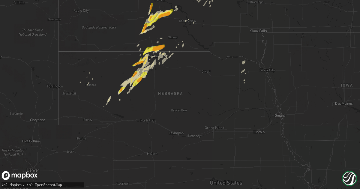
Hail Map in Nebraska on June 17, 2020
Get this storm
June 17 map
$229
one time, instant access
Download today. No call, no setup
Keep the $229
Bought the map and want the full workflow? Apply the entire $229 to a subscription within 7 days. None of it is wasted.
Every map, not just this one
This buys you this map. Subscription and you get every map we run, in the markets you choose from a few cities to whole states to nationwide. Plus real-time alerts the moment a storm fires.
Contact data
Name, contact info, occupancy, even credit band for addresses in the footprint. You go from where it hit to who to call.
Become the source they trust
Unlimited branding weather history reports on demand. You already have the documented answer ready for the property owner, and you are the one who showed up with it.
Property data and RoofTrace estimates
Pull up any address you have got, its value and the exact code rules for that jurisdiction, straight from One Click Code. Then RoofTrace estimates the squares, pitch, and roof value, priced the way you price.
Storm reports in Nebraska
Nebraska
| Date | Description |
|---|---|
| 06/17/20206:18 AM CDT | At 1118 PM CDT/1018 PM MDT/, a severe thunderstorm was located 16 miles west of Brownlee, or 20 miles north of Mullen, moving northeast at 45 mph. HAZARD...Ping pong ball size hail and 60 mph wind gusts. SOURCE...Radar indicated. IMPACT...People and animals outdoors will be injured. Expect hail damage to roofs, siding, windows, and vehicles. Expect wind damage to roofs, siding, and trees. Locations impacted include... Valentine National Wildlife Refuge, Highway 97 crossing the North Loup River, Marsh Flat, Schlagel Creek State Wildlife Management Area, Highway 97 crossing Big Creek, Big Alkali Lake State Wildlife Management Area and Highway 83 crossing Goose Creek.This includes the following highways... Highway 97 between mile markers 84 and 114. Highway 83 between mile markers 177 and 200. |
| 06/17/20205:17 AM CDT | At 1017 PM CDT/917 PM MDT/, a severe thunderstorm was located 13 miles northwest of Mullen, moving northeast at 40 mph. HAZARD...60 mph wind gusts and half dollar size hail. SOURCE...Radar indicated. IMPACT...Hail damage to vehicles is expected. Expect wind damage to roofs, siding, and trees. Locations impacted include... Highway 97 crossing the North Loup River, Marsh Flat, Highway 97 crossing Big Creek and Sevenmile Hill.This includes Highway 97 between mile markers 77 and 107. |
| 06/17/20203:34 AM CDT | At 834 PM MDT, a severe thunderstorm was located near Hyannis, or 30 miles north of Arthur, moving northeast at 30 mph. HAZARD...60 mph wind gusts and half dollar size hail. SOURCE...Radar indicated. IMPACT...Hail damage to vehicles is expected. Expect wind damage to roofs, siding, and trees. Locations impacted include... Hyannis, Whitman, Speckel Meir Lake, Duluth, Hire, Whitman Road crossing the North Branch of the Middle Loup River and Weir.This includes the following highways... Highway 2 between mile markers 146 and 171. Highway 61 between mile markers 154 and 167. |
| 06/17/20203:05 AM CDT | At 805 PM CDT/705 PM MDT/, a severe thunderstorm was located 24 miles southeast of Medicine Lake, or 26 miles north of Mullen, moving northeast at 25 mph. HAZARD...Half dollar size hail. SOURCE...Radar indicated. IMPACT...Damage to vehicles is expected. Locations impacted include... Highway 97 crossing the North Loup River and Highway 97 crossing Big Creek.This includes Highway 97 between mile markers 89 and 112. |
| 06/17/20202:50 AM CDT | At 750 PM MDT, a severe thunderstorm was located 7 miles southwest of Hyannis, or 24 miles north of Arthur, moving northeast at 25 mph. HAZARD...Ping pong ball size hail and 60 mph wind gusts. SOURCE...Radar indicated. IMPACT...People and animals outdoors will be injured. Expect hail damage to roofs, siding, windows, and vehicles. Expect wind damage to roofs, siding, and trees. Locations impacted include... Hyannis, Whitman, Ashby, Duluth, Pratt Lake, Mother Lake and Whitman Road crossing the North Branch of the Middle Loup River.This includes the following highways... Highway 2 between mile markers 137 and 164. Highway 61 between mile markers 143 and 177. |
| 06/17/20202:36 AM CDT | At 736 PM CDT/636 PM MDT/, a severe thunderstorm was located 10 miles southeast of Medicine Lake, or 39 miles southwest of Valentine, moving northeast at 25 mph. HAZARD...Ping pong ball size hail. SOURCE...Radar indicated. IMPACT...People and animals outdoors will be injured. Expect damage to roofs, siding, windows, and vehicles. Locations impacted include... Cody, Schoolhouse Lake, Steer Creek Campground and Anderson Bridge State Wildlife Management Area.This includes Highway 20 between mile markers 156 and 160. |
| 06/17/20201:23 AM CDT | At 623 PM MDT, a severe thunderstorm was located 7 miles northeast of Whitman, or 20 miles west of Mullen, moving northeast at 30 mph. HAZARD...Ping pong ball size hail and 60 mph wind gusts. SOURCE...Radar indicated. IMPACT...People and animals outdoors will be injured. Expect hail damage to roofs, siding, windows, and vehicles. Expect wind damage to roofs, siding, and trees. Locations impacted include... Highway 97 crossing the North Loup River, Whitman Road crossing the North Branch of the Middle Loup River, Speckel Meir Lake, Sevenmile Hill, Weir and Hire.This includes the following highways... Highway 2 between mile markers 167 and 171. Highway 97 between mile markers 91 and 93. |
| 06/16/202011:30 PM CDT | A local report indicates 1.00 inch wind near 14 WNW BROWNLEE |
| 06/16/202010:37 PM CDT | A local report indicates 1.00 inch wind near 15 N MULLEN |
| 06/16/20209:29 PM CDT | A local report indicates 1.00 inch wind near 4 E HYANNIS |
| 06/16/20207:55 PM CDT | A local report indicates 1.00 inch wind near 16 W MERRITT RESERVOIR |
| 06/16/20207:30 PM CDT | A local report indicates 1.50 inch wind near 10 S KILGORE |
| 06/16/20207:08 PM CDT | A local report indicates 1.00 inch wind near KILGORE |
All States Impacted by Hail Map on June 17, 2020
Cities Impacted by Hail Map on June 17, 2020
- Karlstad, MN
- Strandquist, MN
- Greenbush, MN
- Buffalo, ND
- Tower City, ND
- Lamesa, TX
- Odonnell, TX
- Shallowater, TX
- Lubbock, TX
- Strathcona, MN
- Abernathy, TX
- Murdo, SD
- Grafton, ND
- Hallock, MN
- Kennedy, MN
- Presho, SD
- Kennebec, SD
- Draper, SD
- Vivian, SD
- Lower Brule, SD
- Levelland, TX
- Anton, TX
- Hale Center, TX
- Olton, TX
- Littlefield, TX
- Kilgore, NE
- Crookston, NE
- Cody, NE
- Valentine, NE
- Tahoka, TX
- Wilson, TX
- Saint Lawrence, SD
- Stephen, MN
- Page, ND
- Erie, ND
- Galesburg, ND
- Fort Stockton, TX
- Wheatland, ND
- White River, SD
- Frazee, MN
- Oacoma, SD
- Lakota, ND
- Lankin, ND
- Michigan, ND
- Park River, ND
- Lewellen, NE
- Oshkosh, NE
- Seagraves, TX
- Alvarado, MN
- Wessington, SD
- Miller, SD
- Stirum, ND
- Meadow, TX
- Ropesville, TX
- Groton, SD
- Dryden, TX
- Saint Francis, SD
- Plainview, TX
- Kress, TX
- Viking, MN
- Warren, MN
- Amherst, TX
- Sudan, TX
- Mission, SD
- Oakes, ND
- Lorenzo, TX
- Idalou, TX
- Hatton, ND
- Reynolds, ND
- Thompson, ND
- Brownfield, TX
- Sundown, TX
- Hope, ND
- Houghton, SD
- Hecla, SD
- Earth, TX
- Imperial, TX
- Brocket, ND
- Lawton, ND
- Virgil, SD
- Alpena, SD
- Wessington Springs, SD
- Ypsilanti, ND
- Petersburg, TX
- Dickey, ND
- Berlin, ND
- Edgeley, ND
- Argyle, MN
- Muleshoe, TX
- Gail, TX
- Hyannis, NE
- Merriman, NE
- Whitman, NE
- Marathon, TX
- Hartington, NE
- Fordyce, NE
- Sparks, NE
- Springview, NE
- Crary, ND
- Adams, ND
- Blanchard, ND
- Pep, TX
- Fordville, ND
- Gregory, SD
- Dallas, SD
- Minto, ND
- Newfolden, MN
- Wheaton, MN
- Justiceburg, TX
- Fluvanna, TX
- Crystal City, TX
- Randolph, NE
- Coleridge, NE
- Winner, SD
- Seminole, TX
- Lancaster, MN
- Cooperstown, ND
- Wimbledon, ND
- Dazey, ND
- Hannaford, ND
- Welch, TX
- Laurel, NE
- Belden, NE
- Valley City, ND
- Mekinock, ND
- Wolsey, SD
- Alliance, NE
- Westport, SD
- Verona, ND
- Fort Ransom, ND
- Wood, SD
- New Deal, TX
- Coyanosa, TX
- Frederick, SD
- Lake Bronson, MN
- Thedford, NE
- Finley, ND
- Drayton, ND
- Grandfalls, TX
- Gilby, ND
- Grand Forks, ND
- Sanderson, TX
- Columbia, SD
- Oriska, ND
- Kathryn, ND
- Post, TX
- Middle River, MN
- Perham, MN
- Loop, TX
- Ayr, ND
- Hunter, ND
- Manvel, ND
- Luverne, ND
- Beltrami, MN
- Barnard, SD
- Tulare, SD
- Clifford, ND
- Rosholt, SD
- East Grand Forks, MN
- Binford, ND
- Hemingford, NE
- Lisbon, ND
- Nome, ND
- Ellendale, ND
- Chamberlain, SD
- Norris, SD
- Okaton, SD
- Aneta, ND
- Jessie, ND
- Enderlin, ND
- Pelican Rapids, MN
- Detroit Lakes, MN
- Audubon, MN
- Pillsbury, ND
- Cogswell, ND
- Colome, SD
- Ashby, NE
- Badger, MN
- Amenia, ND
- Arthur, ND
- Warwick, ND
- Hillsboro, ND
- Euclid, MN
- Forest River, ND
- Donaldson, MN
- Absaraka, ND
- Fingal, ND
- Leola, SD
- Wynot, NE
- Harrold, SD
- Mcville, ND
- Pukwana, SD
- Carroll, NE
- Winside, NE
- Marion, ND
- Arthur, NE
- Dimmitt, TX
- Johnstown, NE
- Carrizo Springs, TX
- Edinburg, ND
- Hoskins, NE
- Pekin, ND
- Pisek, ND
- Dahlen, ND
- Petersburg, ND
- Wood Lake, NE
- Leonard, MN
- Snyder, TX
- Rogers, ND
- Sanborn, ND
- Shevlin, MN
- Fort Pierre, SD
- Ralls, TX
- Tulia, TX
- Slaton, TX
- Crosbyton, TX
- Portland, ND
- Mayville, ND
- Oslo, MN
- Climax, MN
- Crookston, MN
- Roseau, MN
- Aberdeen, SD
- Henry, SD
- Watertown, SD
- Hazel, SD


