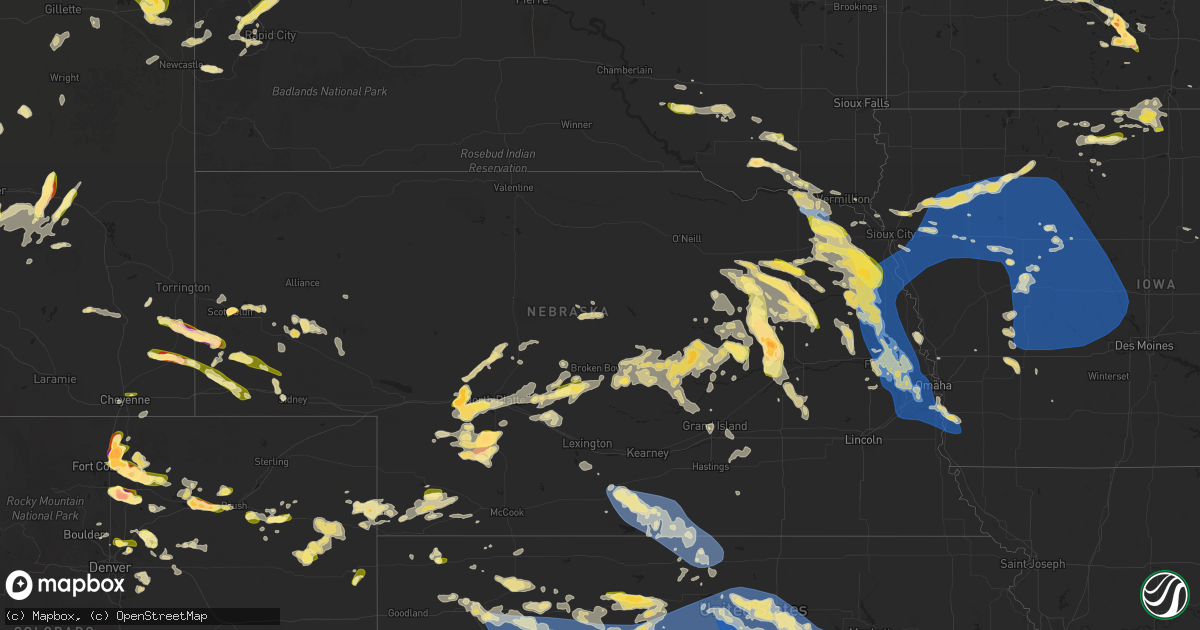
Hail Map in Nebraska on June 16, 2025
Get this storm
June 16 map
$229
one time, instant access
Download today. No call, no setup
Keep the $229
Bought the map and want the full workflow? Apply the entire $229 to a subscription within 7 days. None of it is wasted.
Every map, not just this one
This buys you this map. Subscription and you get every map we run, in the markets you choose from a few cities to whole states to nationwide. Plus real-time alerts the moment a storm fires.
Contact data
Name, contact info, occupancy, even credit band for addresses in the footprint. You go from where it hit to who to call.
Become the source they trust
Unlimited branding weather history reports on demand. You already have the documented answer ready for the property owner, and you are the one who showed up with it.
Property data and RoofTrace estimates
Pull up any address you have got, its value and the exact code rules for that jurisdiction, straight from One Click Code. Then RoofTrace estimates the squares, pitch, and roof value, priced the way you price.
Storm reports in Nebraska
Nebraska
| Date | Description |
|---|---|
| 06/16/20256:22 PM CDT | A local report indicates 1.00 inch wind near 4 S Norfolk |
| 06/16/20256:20 PM CDT | A local report indicates 1.00 inch wind near 7 W Stanton |
| 06/16/20256:17 PM CDT | A local report indicates 1.50 inch wind near 5 S Norfolk |
| 06/16/20256:17 PM CDT | Personal weather station measured wind gust of 64 mph. |
| 06/16/20256:10 PM CDT | A local report indicates 1.00 inch wind near 2 SSW Neligh |
| 06/16/20255:43 PM CDT | A local report indicates 1.00 inch wind near 4 NNE Meadow Grove |
| 06/16/20255:40 PM CDT | Delayed public report shared on social media with a hailstone measured at 1 inch in diameter. Time estimated from radar. |
| 06/16/20255:15 PM CDT | Law enforcement report of hail up to quarter sized along with heavy rain. |
| 06/16/20255:13 PM CDT | Emergency management report of heavy rain and wind gusts of 50-60 mph. |
| 06/16/20255:13 PM CDT | Emergency management report of straight line winds gusting at 60-65 mph. |
| 06/16/20255:11 PM CDT | Accompanied by 45 mph winds. |
| 06/16/20255:05 PM CDT | Public report of hail estimated up to 1 inch in diameter. |
| 06/16/20254:30 PM CDT | Emergency management report of irrigation flipped two miles south of laurel along with power lines down in that area. Time estimated with radar. |
| 06/16/20254:28 PM CDT | Report via social media. Trees knocked down by thunderstorm wind gusts. |
| 06/16/20254:02 PM CDT | A local report indicates 1.00 inch wind near Hartington |
| 06/16/20254:00 PM CDT | Mesonet measured wind gust of 58 mph. |
| 06/16/20254:00 PM CDT | Mesonet measured wind gust of 63 mph. |
| 06/16/20252:45 AM CDT | A local report indicates 1.00 inch wind near 10 SE Harrisburg |
| 06/16/20251:58 AM CDT | A local report indicates 1.00 inch wind near Kimball |
| 06/16/20251:52 AM CDT | Several house windows blown out by hailstones. |
| 06/16/20251:31 AM CDT | A local report indicates 1.00 inch wind near 10 N Bushnell |
| 06/16/20251:21 AM CDT | A local report indicates 1.75 inch wind near 0.5 E Scottsbluff |
| 06/16/20251:17 AM CDT | A local report indicates 1.50 inch wind near 2 E Scottsbluff |
| 06/15/202511:19 PM CDT | A local report indicates 62 MPH wind near Franklin |
| 06/15/202511:01 PM CDT | A local report indicates 64 MPH wind near 3 W Republican City |
| 06/15/202511:00 PM CDT | Time estimated from radar. Lots of trees broken off throughout town with some large branches. |
| 06/15/202510:53 PM CDT | Site wl-bloomington8.16nnw. |
| 06/15/202510:50 PM CDT | Site pws-knewilco20. |
| 06/15/202510:48 PM CDT | A local report indicates 63 MPH wind near 1 N Republican City |
| 06/15/202510:47 PM CDT | A local report indicates 63 MPH wind near 6 WSW Ragan |
| 06/15/202510:46 PM CDT | A local report indicates 63 MPH wind near 3 W Republican City |
| 06/15/202510:45 PM CDT | A local report indicates 62 MPH wind near 7 ENE Huntley |
| 06/15/202510:43 PM CDT | A local report indicates 73 MPH wind near 4 SE Huntley |
| 06/15/202510:40 PM CDT | Social media report of estimated 60 mph wind gust. |
| 06/15/202510:38 PM CDT | Site wl-huntley3.86ene. |
| 06/15/202510:33 PM CDT | A local report indicates 58 MPH wind near 6 W Huntley |
| 06/15/202510:21 PM CDT | A local report indicates 68 MPH wind near 2 ENE Hastings |
| 06/15/202510:19 PM CDT | A local report indicates 70 MPH wind near 5 SSW Hastings |
| 06/15/202510:18 PM CDT | A local report indicates 67 MPH wind near 2 E Juniata |
| 06/15/202510:16 PM CDT | A local report indicates 59 MPH wind near 4 SW Hastings |
| 06/15/202510:16 PM CDT | A local report indicates 59 MPH wind near 4 SW Hastings |
| 06/15/202510:16 PM CDT | Pictures shared on facebook of tree damage on southern hills golf course. |
| 06/15/202510:13 PM CDT | Em reports some trees down and powerline on a car near center of city. |
| 06/15/202510:13 PM CDT | A local report indicates 61 MPH wind near Hastings Airport |
| 06/15/202510:10 PM CDT | Estimated 60 to 65 mph winds at nws hastings office. |
| 06/15/202510:08 PM CDT | A local report indicates 59 MPH wind near Grand Island Airport |
| 06/15/202510:06 PM CDT | A local report indicates 59 MPH wind near Ord Airport |
| 06/15/20259:48 PM CDT | Delayed report from yesterdays storms. Nws employee reports numerous tree branches and limbs 2-8 inches in diameter across various portions of grand island. Time estima |
| 06/15/20259:43 PM CDT | Also reported 50 to 60mph winds. |
| 06/15/20259:40 PM CDT | Report from site kneraven17. |
| 06/15/20259:34 PM CDT | A local report indicates 1.75 inch wind near Sutherland |
| 06/15/20259:28 PM CDT | Estimated brief 60 mph wind gust. |
| 06/15/20259:28 PM CDT | Estimated 40-50 mph persisting winds with brief gusts up to 60 mph. |
| 06/15/20259:20 PM CDT | Report from mping. |
| 06/15/20259:18 PM CDT | Estimated winds 50 to 60 mph... Also hail up to dime size. |
| 06/15/20259:16 PM CDT | Brief wind gust |
| 06/15/20259:16 PM CDT | Brief wind gusts up to 60 mph. |
| 06/15/20259:14 PM CDT | A local report indicates 1.00 inch wind near 12 S Wallace |
| 06/15/20258:55 PM CDT | Large branch down on property. Reports of several other reports of 2 to 4 inch branches down in town. |
| 06/15/20258:55 PM CDT | Several reports of branches at least 2 to 4 inch diameter down in town... Including from off-duty nws. |
| 06/15/20258:45 PM CDT | A local report indicates 1.00 inch wind near 3 NE Belgrade |
| 06/15/20258:43 PM CDT | A local report indicates 1.00 inch wind near 2 SW Maxwell |
| 06/15/20258:31 PM CDT | Personal weather station measured gust of 61 mph... Likely associated with the passing of an outflow boundary. |
| 06/15/20258:29 PM CDT | Quarter size hail. |
| 06/15/20258:25 PM CDT | A local report indicates 1.00 inch wind near Cedar Rapids |
| 06/15/20258:24 PM CDT | Up to quarter size hail...most smaller. |
| 06/15/20258:19 PM CDT | A local report indicates 1.00 inch wind near Genoa |
| 06/15/20258:15 PM CDT | Updates previous tstm wnd gst report from lexington airport. Intense gusts several miles out ahead of nearby thunderstorms. Dispatch reporting some tree and power line |
| 06/15/20258:15 PM CDT | Update to previous tstm wnd dmg report from lexington. Preliminary reports of of tree and power line damage in town. Extent unknown at this time. It appears this likely |
| 06/15/20258:15 PM CDT | Preliminary reports of of tree and power line damage in town. Extent unknown at this time. |
| 06/15/20258:15 PM CDT | Intense gusts several miles out ahead of nearby thunderstorms. Dispatch reporting some tree and power line damage. |
| 06/15/20258:09 PM CDT | Corrects previous hail report from 2 sw maxwell. |
| 06/15/20258:09 PM CDT | A local report indicates 1.75 inch wind near 8 E Saint Edward |
| 06/15/20257:48 PM CDT | Personal weather station measured wind gust of 63 mph. |
| 06/15/20257:32 PM CDT | A local report indicates 1.00 inch wind near 5 SW Newman Grove |
| 06/15/20257:25 PM CDT | A local report indicates 2.50 inch wind near 5 E Dickens |
| 06/15/20257:21 PM CDT | Personal weather station measured wind gust of 64 mph. |
| 06/15/20257:21 PM CDT | Personal weather station measured wind gust of 64 mph. |
| 06/15/20257:21 PM CDT | Personal weather station measured wind gust of 64 mph. |
| 06/15/20257:07 PM CDT | Multiple reports over phone and social media of tornado on the ground. |
| 06/15/20257:06 PM CDT | Report of snapped tree limbs of 3 inches in diameter. |
| 06/15/20257:04 PM CDT | [landspout] landspout touched down and moved to the west-southwest for approximately 1 mile before ending. |
All States Impacted by Hail Map on June 16, 2025
Cities Impacted by Hail Map on June 16, 2025
- Emmons, MN
- Alden, MN
- Pelican Rapids, MN
- Vergas, MN
- Albert Lea, MN
- Lake Mills, IA
- Scarville, IA
- Twin Lakes, MN
- Wells, MN
- Dent, MN
- Chaska, MN
- Cologne, MN
- Kiester, MN
- Northwood, IA
- Joice, IA
- Thompson, IA
- Appleton, MN
- Leland, IA
- Holloway, MN
- Bertha, MN
- Verndale, MN
- Willmar, MN
- Kandiyohi, MN
- Armstrong, IA
- Rockford, IA
- Lone Rock, IA
- Fenton, IA
- Dolliver, IA
- Marble Rock, IA
- Bancroft, IA
- Burt, IA
- Titonka, IA
- Swea City, IA
- Montgomery, MN
- Woden, IA
- Buffalo Center, IA
- Greene, IA
- Clarksville, IA
- Maple Lake, MN
- Annandale, MN
- Lu Verne, IA
- Forest City, IA
- Algona, IA
- Britt, IA
- Melrose, MN
- Freeport, MN
- Albany, MN
- Kanawha, IA
- Grey Eagle, MN
- Avon, MN
- Kimball, SD
- Saint Joseph, MN
- Sartell, MN
- Holdingford, MN
- Platte, SD
- White Lake, SD
- Saint Stephen, MN
- Excelsior, MN
- Stickney, SD
- Harrison, SD
- Corsica, SD
- Clearwater, MN
- South Haven, MN
- Kimball, MN
- Lumberton, MS
- Mound, MN
- Waite Park, MN
- Saint Cloud, MN
- Sauk Rapids, MN
- Iowa Falls, IA
- Monticello, MN
- Buffalo, MN
- Steamboat Rock, IA
- Erhard, MN
- Ackley, IA
- Mount Vernon, SD
- Long Lake, MN
- Wayzata, MN
- Hanover, MN
- Saint Michael, MN
- Loretto, MN
- Rockford, MN
- Houston, TX
- Rogers, MN
- Hamel, MN
- Salemburg, NC
- Edgewood, IA
- Strawberry Point, IA
- Kinston, NC
- Dover, NC
- Dimock, SD
- Parkston, SD
- Ethan, SD
- Minneapolis, MN
- Maple Plain, MN
- Tyndall, SD
- Scotland, SD
- Wilsall, MT
- Clinton, NC
- Osseo, MN
- Maple Grove, MN
- Avon, SD
- Plankinton, SD
- Maysville, NC
- Hopkins, MN
- Minnetonka, MN
- Kountze, TX
- Warren, TX
- Armour, SD
- Lesterville, SD
- Tabor, SD
- Turkey, NC
- Meridian, MS
- Yankton, SD
- Utica, SD
- Frederic, WI
- Havelock, NC
- Beaumont, TX
- Marion, MS
- Daleville, MS
- Lauderdale, MS
- Mission Hill, SD
- Crofton, NE
- Fordyce, NE
- Olivet, SD
- Tripp, SD
- Thermopolis, WY
- Gayville, SD
- Saint Helena, NE
- Menno, SD
- Shawmut, MT
- Melville, MT
- Livingston, MT
- Red Lodge, MT
- Hartington, NE
- Vermillion, SD
- Livingston, TX
- Ryegate, MT
- Big Timber, MT
- Coleridge, NE
- Laurel, NE
- Carbon Hill, AL
- Roberts, MT
- Wynot, NE
- Dixon, NE
- Newcastle, NE
- Belden, NE
- Carroll, NE
- Chinquapin, NC
- Motley, MN
- Pine River, MN
- Staples, MN
- Burbank, SD
- Pequot Lakes, MN
- Pillager, MN
- Randolph, NE
- Allen, NE
- Wayne, NE
- Concord, NE
- Wakefield, NE
- Osmond, NE
- Pierce, NE
- Scobey, MT
- Elk Point, SD
- Ponca, NE
- Nisswa, MN
- Richlands, NC
- Royal, NE
- Clearwater, NE
- Watkins, MN
- Jefferson, SD
- Brunswick, NE
- Neligh, NE
- Plainview, NE
- Bridger, MT
- Emerson, NE
- Broadview, MT
- Merrill, IA
- Hinton, IA
- Clarkson, NE
- Hubbard, NE
- Thurston, NE
- Howells, NE
- Wisner, NE
- Sioux City, IA
- Dakota City, NE
- South Sioux City, NE
- Beemer, NE
- Columbus, NE
- Bancroft, NE
- West Point, NE
- Pender, NE
- Dodge, NE
- Schuyler, NE
- Bellwood, NE
- Winnebago, NE
- Homer, NE
- Hayneville, AL
- Hull, TX
- Lavina, MT
- Westfield, IA
- Pilger, NE
- Autaugaville, AL
- Liberty, TX
- Jacksonville, NC
- Thomasville, NC
- Brainerd, MN
- Merrifield, MN
- Tilden, NE
- Cleveland, TX
- Austin, MN
- Reed Point, MT
- Maple Hill, NC
- Monticello, AR
- Carver, MN
- Crosby, MN
- Ironton, MN
- Moville, IA
- Waterbury, NE
- Fort Ripley, MN
- Baxter, MN
- Kingsley, IA
- Le Mars, IA
- Saratoga, TX
- Flaxville, MT
- Walthill, NE
- Dassel, MN
- Darwin, MN
- Pierce, CO
- Cokato, MN
- Nunn, CO
- Ault, CO
- Remsen, IA
- Rapelje, MT
- Meadow Grove, NE
- Deerwood, MN
- Pierson, IA
- Garrett, WY
- Sergeant Bluff, IA
- Salix, IA
- Pavillion, WY
- Acton, MT
- Rosalie, NE
- Hoskins, NE
- Eden Valley, MN
- Glenrock, WY
- Norfolk, NE
- Correctionville, IA
- Flagler, CO
- Molt, MT
- Aitkin, MN
- Garrison, MN
- Cleghorn, IA
- Meriden, IA
- Cherokee, IA
- Marcus, IA
- Silver Lake, MN
- Winsted, MN
- Bearcreek, MT
- Minot, ND
- Litchfield, MN
- Riverton, WY
- Sutherland, IA
- Larrabee, IA
- Peterson, IA
- Seibert, CO
- Casper, WY
- Bronson, IA
- Lawton, IA
- Hornick, IA
- Lyons, NE
- Macy, NE
- Sloan, IA
- Whiting, IA
- Climbing Hill, IA
- Battle Creek, IA
- Danbury, IA
- Holstein, IA
- Onawa, IA
- Decatur, NE
- Anthon, IA
- Quimby, IA
- Washta, IA
- Oto, IA
- Smithland, IA
- Cushing, IA
- Paullina, IA
- Aurelia, IA
- Howard Lake, MN
- Hillman, MN
- Pierz, MN
- Laurel, MT
- Park City, MT
- Jemison, AL
- Douglas, WY
- Stanton, NE
- Sleepy Eye, MN
- Shepherd, MT
- Billings, MT
- Isle, MN
- Eaton, CO
- Oakdale, NE
- Battle Creek, NE
- Winside, NE
- Glencoe, MN
- Brockton, MT
- Climax, NC
- Franklinville, NC
- Rodney, IA
- Tekamah, NE
- Mapleton, IA
- Castana, IA
- Albert City, IA
- Ida Grove, IA
- Schaller, IA
- Galva, IA
- Storm Lake, IA
- Rembrandt, IA
- Linn Grove, IA
- Truesdale, IA
- Alta, IA
- New Ulm, MN
- Gibbon, MN
- Velva, ND
- Norwich, ND
- Onamia, MN
- Wyola, MT
- Sioux Rapids, IA
- Webb, IA
- Waverly, MN
- McGrath, MN
- Huntley, MT
- Watertown, MN
- Fairfax, MN
- Lafayette, MN
- Greenville, IA
- Calera, AL
- Waverly, GA
- Fulshear, TX
- New Germany, MN
- Lester Prairie, MN
- Mayer, MN
- Richmond, TX
- White Oak, GA
- Sturgeon Lake, MN
- Foley, MN
- Young America, MN
- Woodbine, GA
- Winthrop, MN
- Finlayson, MN
- Shoshoni, WY
- Plato, MN
- Madison, NE
- Ballantine, MT
- Montrose, MN
- Delano, MN
- Lodge Grass, MT
- Ruthven, IA
- Ayrshire, IA
- Liberty, NC
- Odebolt, IA
- Arthur, IA
- Oakland, NE
- Hardin, MT
- Pompeys Pillar, MT
- Worden, MT
- Craig, NE
- Scribner, NE
- Hooper, NE
- Kiron, IA
- Nemaha, IA
- Lake View, IA
- Wall Lake, IA
- Early, IA
- Newell, IA
- Laurens, IA
- Varina, IA
- Curlew, IA
- Havelock, IA
- Pocahontas, IA
- Marathon, IA
- Fonda, IA
- Mallard, IA
- Sac City, IA
- Elgin, NE
- Petersburg, NE
- Bozeman, MT
- Voltaire, ND
- Nicollet, MN
- Gaylord, MN
- Foreston, MN
- Milaca, MN
- Oak Park, MN
- Waconia, MN
- McDonald, KS
- Herman, NE
- Nickerson, NE
- Kennard, NE
- Winslow, NE
- Arlington, NE
- Ames, NE
- Fremont, NE
- Uehling, NE
- Blair, NE
- Leigh, NE
- Newman Grove, NE
- Albion, NE
- Pomeroy, IA
- Norwood Young America, MN
- Lakota, IA
- Balfour, ND
- Ewing, NE
- Shakopee, MN
- Henderson, MN
- Green Isle, MN
- Breda, IA
- Mora, MN
- Auburn, IA
- Modale, IA
- Spring Park, MN
- Saint Francis, KS
- Palmer, IA
- Bridgeport, NE
- Mondamin, IA
- Redstone, MT
- Rockwell City, IA
- Lindsay, NE
- Lytton, IA
- Lake City, IA
- Manson, IA
- Jolley, IA
- Rolfe, IA
- Plover, IA
- Gilmore City, IA
- Valley, NE
- Cedar Bluffs, NE
- Bennington, NE
- Mead, NE
- Colon, NE
- Fort Calhoun, NE
- Yutan, NE
- Omaha, NE
- Washington, NE
- Elkhorn, NE
- Victoria, MN
- Chanhassen, MN
- Carroll, IA
- Rockford, AL
- Missouri Valley, IA
- Bird City, KS
- Arcadia, IA
- Saint Peter, MN
- Mankato, MN
- Parkman, WY
- Creston, NE
- Brook Park, MN
- Humphrey, NE
- Ranchester, WY
- Wellfleet, NE
- Belle Plaine, MN
- Eden Prairie, MN
- Kasota, MN
- Jordan, MN
- Somers, IA
- Manilla, IA
- Sheridan, WY
- North Platte, NE
- Waterloo, NE
- Saint Edward, NE
- Moorland, IA
- Farnhamville, IA
- Lohrville, IA
- Barnum, IA
- Knierim, IA
- Lehigh, IA
- Clare, IA
- Bradgate, IA
- Burnside, IA
- Humboldt, IA
- Gowrie, IA
- Callender, IA
- Fort Dodge, IA
- Otho, IA
- Churdan, IA
- Harcourt, IA
- Scranton, IA
- Glidden, IA
- Dedham, IA
- Westside, IA
- Manning, IA
- Templeton, IA
- Dayton, IA
- Halbur, IA
- Paton, IA
- Lanesboro, IA
- Audubon, IA
- Ralston, IA
- Lidderdale, IA
- Jefferson, IA
- Vail, IA
- Idalia, CO
- Brady, NE
- North Bend, NE
- Decker, MT
- Madison Lake, MN
- Bartlett, NE
- Rogers, NE
- Primrose, NE
- Saint Bonifacius, MN
- Eagle Lake, MN
- Janesville, MN
- Pemberton, MN
- Greeley, NE
- Gothenburg, NE
- Callaway, NE
- Good Thunder, MN
- Mapleton, MN
- Irwin, IA
- Ericson, NE
- Lake Crystal, MN
- Cedar Rapids, NE
- Genoa, NE
- Akron, CO
- Spalding, NE
- Cope, CO
- Prior Lake, MN
- La Vista, NE
- Papillion, NE
- Boys Town, NE
- Springfield, NE
- Gretna, NE
- Ashland, NE
- Bellevue, NE
- Monroe, NE
- Kimballton, IA
- Coon Rapids, IA
- Gray, IA
- Bayard, IA
- Dana, IA
- Beaver, IA
- Madrid, IA
- Perry, IA
- Jamaica, IA
- Pilot Mound, IA
- Stratford, IA
- Grand Junction, IA
- Ogden, IA
- Bagley, IA
- Rippey, IA
- Boone, IA
- Boxholm, IA
- Dickens, NE
- Mcclusky, ND
- Custer, SD
- Kirkman, IA
- Harlan, IA
- Scotia, NE
- Oconto, NE
- Clearmont, WY
- Wolbach, NE
- Rake, IA
- Lakeville, MN
- Council Bluffs, IA
- Elko New Market, MN
- Saint Clair, MN
- Cedar Creek, NE
- Louisville, NE
- South Bend, NE
- Plattsmouth, NE
- Woodward, IA
- Exira, IA
- Casey, IA
- Guthrie Center, IA
- Panora, IA
- Hamlin, IA
- Yale, IA
- Elk Horn, IA
- Dawson, IA
- Adair, IA
- Brayton, IA
- Menlo, IA
- Linden, IA
- Dallas Center, IA
- Stuart, IA
- Redfield, IA
- Bouton, IA
- Adel, IA
- Minburn, IA
- Luther, IA
- Granger, IA
- Silver Creek, NE
- Platte Center, NE
- Belgrade, NE
- Maywood, NE
- Hayes Center, NE
- Yuma, CO
- Shelby, IA
- Westerville, NE
- Arcadia, NE
- Stacy, MN
- Wyoming, MN
- Midwest, WY
- Offutt Afb, NE
- Wahoo, NE
- Minnesota Lake, MN
- North Loup, NE
- Bethel, MN
- Cedar, MN
- Fountain City, WI
- Minnesota City, MN
- Ord, NE
- Fullerton, NE
- Arvada, WY
- Eckley, CO
- Forest Lake, MN
- Chisago City, MN
- Regan, ND
- Gillette, WY
- Broken Bow, NE
- Hill City, SD
- Comstock, NE
- Arcadia, WI
- Rapid City, SD
- Pacific Junction, IA
- Loup City, NE
- Deadwood, SD
- Wing, ND
- Atwood, KS
- Ansley, NE
- Glenwood, IA
- Shelby, NE
- Marne, IA
- Newcastle, WY
- Elba, NE
- Scandia, MN
- Lead, SD
- Osceola, NE
- Selden, KS
- Ashton, NE
- Walnut, IA
- Wray, CO
- Nemo, SD
- Piedmont, SD
- Palmer, NE
- Atlantic, IA
- Mason City, NE
- Black Hawk, SD
- Malvern, IA
- Vernon, CO
- Saint Paul, NE
- Haigler, NE
- Ettrick, WI
- Cozad, NE
- Recluse, WY
- Murray, NE
- Tabor, IA
- Thurman, IA
- Sturgis, SD
- Sutherland, NE
- Merna, NE
- Arnold, NE
- Anselmo, NE
- Stromsburg, NE
- Gresham, NE
- Litchfield, NE
- Wallace, NE
- Rising City, NE
- Rockville, NE
- Benkelman, NE
- Wiota, IA
- Rozet, WY
- Weston, WY
- Hershey, NE
- Prescott, IA
- Tuttle, ND
- Bertrand, NE
- Melrose, WI
- Boelus, NE
- Farwell, NE
- Ulysses, NE
- Wauneta, NE
- Moorcroft, WY
- Dresden, KS
- Eustis, NE
- Dannebrog, NE
- Smithfield, NE
- Elwood, NE
- Surprise, NE
- Sparta, WI
- Steele, ND
- Palisade, NE
- Mindoro, WI
- Utica, NE
- Jennings, KS
- Atlanta, NE
- Holdrege, NE
- Grand Island, NE
- Cairo, NE
- Tryon, NE
- Alda, NE
- Saint Libory, NE
- Phillips, NE
- Aurora, NE
- Chapman, NE
- Maxwell, NE
- Giltner, NE
- Norwalk, WI
- Hoxie, KS
- Sundance, WY
- Devils Tower, WY
- Orleans, NE
- Harvard, NE
- Alma, NE
- Stapleton, NE
- Trumbull, NE
- Fairfield, NE
- Deweese, NE
- Upton, WY
- Republican City, NE
- Colby, KS
- Wilton, WI
- Wilcox, NE
- Naponee, NE
- Wheatland, WY
- Kendall, WI
- Bloomington, NE
- Stockton, KS
- Levant, KS
- Lexington, NE
- Elroy, WI
- Franklin, NE
- Oxford, NE
- Kensington, KS
- Hildreth, NE
- Riverton, NE
- Smith Center, KS
- Campbell, NE
- Inavale, NE
- Bladen, NE
- Upland, NE
- Woodston, KS
- Rexford, KS
- Morland, KS
- Red Cloud, NE
- Lebanon, KS
- Hill City, KS
- Gem, KS
- Alton, KS
- Oakley, KS
- Penokee, KS
- Brewster, KS
- Gaylord, KS
- Portis, KS
- Esbon, KS
- Lorimor, IA
- Mankato, KS
- Brewster, NE
- Natoma, KS
- Plainville, KS
- Cheyenne, WY
- Burr Oak, KS
- Guide Rock, NE
- Meriden, WY
- Taylor, NE
- Osborne, KS
- Bogue, KS
- Downs, KS
- Palco, KS
- Glen Elder, KS
- Tipton, KS
- Beloit, KS
- Yoder, WY
- Albin, WY
- Pine Bluffs, WY
- Paradise, KS
- Waldo, KS
- Harrisburg, NE
- Ellis, KS
- Catharine, KS
- Hays, KS
- Victoria, KS
- Russell, KS
- Quinter, KS
- Grinnell, KS
- Wakeeney, KS
- Park, KS
- Collyer, KS
- Grainfield, KS
- Ogallah, KS
- Gorham, KS
- Randall, KS
- Union Center, SD
- Elsie, NE
- Bushnell, NE
- Minatare, NE
- Simpson, KS
- Scottsbluff, NE
- Gering, NE
- Parks, NE
- Bunker Hill, KS
- Bayard, NE
- Hawk Springs, WY
- Glasco, KS
- Concordia, KS
- Barnard, KS
- Walker, KS
- Delphos, KS
- Lucas, KS
- McCracken, KS
- Bison, KS
- Liebenthal, KS
- Schoenchen, KS
- La Crosse, KS
- Luray, KS
- Brownell, KS
- Pfeifer, KS
- Sylvan Grove, KS
- Hunter, KS
- Jamestown, KS
- Minneapolis, KS
- Kimball, NE
- Max, NE
- Angora, NE
- Dorrance, KS
- Stratton, NE
- Lagrange, WY
- Otis, KS
- Lyman, NE
- Lincoln, KS
- Beverly, KS
- Tescott, KS
- Bennington, KS
- Aurora, KS
- Miltonvale, KS
- Hoisington, KS
- Rush Center, KS
- Olmitz, KS
- Wilson, KS
- Albert, KS
- Great Bend, KS
- Holyrood, KS
- Kanopolis, KS
- Salina, KS
- Lorraine, KS
- Brookville, KS
- Claflin, KS
- Ellsworth, KS
- Lakeside, NE
- Dix, NE
- Broadwater, NE
- Trenton, NE
- Solomon, KS
- New Cambria, KS
- Clay Center, KS
- Bushton, KS
- Longford, KS
- Enders, NE
- Pawnee Rock, KS
- Ellinwood, KS
- Larned, KS
- St John, KS
- Chase, KS
- Geneseo, KS
- Hudson, KS
- Marquette, KS
- Lyons, KS
- Raymond, KS
- Abilene, KS
- Falun, KS
- Assaria, KS
- Talmage, KS
- Gypsum, KS
- Little River, KS
- Lindsborg, KS
- Fort Collins, CO
- Herndon, KS
- Medicine Bow, WY
- Oberlin, KS
- Lisco, NE
- Windsor, CO
- Severance, CO
- Wellington, CO
- Greeley, CO
- Lucerne, CO
- Potter, NE
- Sterling, KS
- Inman, KS
- Partridge, KS
- Sylvia, KS
- Turon, KS
- Plevna, KS
- Abbyville, KS
- Cunningham, KS
- Arlington, KS
- Mcpherson, KS
- Windom, KS
- Alden, KS
- Nickerson, KS
- Hutchinson, KS
- Stafford, KS
- Fe Warren Afb, WY
- Damar, KS
- Enterprise, KS
- Wakefield, KS
- Woodbine, KS
- Chapman, KS
- Junction City, KS
- Milford, KS
- Kingman, KS
- South Hutchinson, KS
- Pretty Prairie, KS
- Haven, KS
- Roxbury, KS
- Burrton, KS
- Moundridge, KS
- Buhler, KS
- Canton, KS
- Galva, KS
- Carr, CO
- Gill, CO
- Gurley, NE
- Dalton, NE
- Spivey, KS
- Murdock, KS
- Cheney, KS
- Lehigh, KS
- Valley Center, KS
- Halstead, KS
- Sedgwick, KS
- Bentley, KS
- Maize, KS
- Andale, KS
- Goddard, KS
- Wichita, KS
- Garden Plain, KS
- Mount Hope, KS
- Colwich, KS
- Briggsdale, CO
- Johnstown, CO
- Loveland, CO
- Norwich, KS
- Argonia, KS
- Milton, KS
- Hesston, KS
- Peabody, KS
- Newton, KS
- North Newton, KS
- Viola, KS
- Walton, KS
- Goessel, KS
- Hillsboro, KS
- Clearwater, KS
- Milliken, CO
- Sidney, NE
- Kersey, CO
- Orchard, CO
- Zenda, KS
- Evans, CO
- Wiggins, CO
- Harper, KS
- Conway Springs, KS
- Milan, KS
- Whitewater, KS
- Marion, KS
- Mayfield, KS
- Kechi, KS
- Greenwich, KS
- Belle Plaine, KS
- Mcconnell Afb, KS
- Peck, KS
- Derby, KS
- Haysville, KS
- Wellington, KS
- Weldona, CO
- La Salle, CO
- Gilcrest, CO
- Platteville, CO
- Fort Morgan, CO
- Freeport, KS
- Danville, KS
- Florence, KS
- Elbing, KS
- Andover, KS
- Towanda, KS
- El Dorado, KS
- Potwin, KS
- Benton, KS
- Burns, KS
- Rose Hill, KS
- Mulvane, KS
- Douglass, KS
- Udall, KS
- Hudson, CO
- Brighton, CO
- Lafayette, CO
- Longmont, CO
- Timnath, CO
- Keenesburg, CO
- Anthony, KS
- Broomfield, CO
- Denver, CO
- Thornton, CO
- Erie, CO
- Bennett, CO
- Snyder, CO
- Caldwell, KS
- Oxford, KS
- South Haven, KS
- Log Lane Village, CO
- Geuda Springs, KS
- Bluff City, KS
- Henderson, CO
- Augusta, KS
- Medford, OK
- Atlanta, KS
- Winfield, KS
- Rock, KS
- Leon, KS
- Arkansas City, KS
- Braman, OK
- Newkirk, OK
- Burden, KS
- Nardin, OK
- Deer Creek, OK
- Lamont, OK
- Dexter, KS
- Ponca City, OK
- Blackwell, OK
- Tonkawa, OK
- Commerce City, CO
- Brush, CO
- Strasburg, CO
- Fort Lupton, CO
- Aurora, CO
- Marland, OK
- Red Rock, OK
- Maple City, KS
- Kaw City, OK
- Irene, SD
- Byers, CO
- Watkins, CO
- Elmore, MN
- Ralston, OK
- Mitchell, NE
- Perry, OK
- Billings, OK
- Pawnee, OK
- Morrison, OK
- Stillwater, OK
- Glencoe, OK
- Ripley, OK
- Perkins, OK
- Yale, OK
- Parker, CO
- Otis, CO
- Berthoud, CO
- Henning, MN
- Perham, MN


