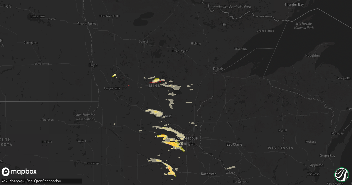
Hail Map in Minnesota on June 16, 2025
Get this storm
June 16 map
$229
one time, instant access
Download today. No call, no setup
Keep the $229
Bought the map and want the full workflow? Apply the entire $229 to a subscription within 7 days. None of it is wasted.
Every map, not just this one
This buys you this map. Subscription and you get every map we run, in the markets you choose from a few cities to whole states to nationwide. Plus real-time alerts the moment a storm fires.
Contact data
Name, contact info, occupancy, even credit band for addresses in the footprint. You go from where it hit to who to call.
Become the source they trust
Unlimited branding weather history reports on demand. You already have the documented answer ready for the property owner, and you are the one who showed up with it.
Property data and RoofTrace estimates
Pull up any address you have got, its value and the exact code rules for that jurisdiction, straight from One Click Code. Then RoofTrace estimates the squares, pitch, and roof value, priced the way you price.
Storm reports in Minnesota
Minnesota
| Date | Description |
|---|---|
| 06/16/20256:44 PM CDT | Nws employee reported half dollar sized hail in waconia. |
| 06/16/20256:36 PM CDT | Storms chasers confirmed brief tornado touched down just north of courtland. |
| 06/16/20256:30 PM CDT | Large tree branch broken off mature tree... Several inches in diameter. Photo via social media. Time estimated. |
| 06/16/20256:28 PM CDT | Large limb broken off mature tree. Time estimated from radar. |
| 06/16/20256:17 PM CDT | Around an 8 inch diameter pine tree down. Multiple other branches down. Time estimated by radar. |
| 06/16/20255:46 PM CDT | A local report indicates 1.75 inch wind near 2 ESE Cokato |
| 06/16/20255:44 PM CDT | A local report indicates 1.00 inch wind near Cokato |
| 06/16/20255:30 PM CDT | Debris reported in the air and on the ground. |
| 06/16/20255:25 PM CDT | Multiple reports of quarter sized hail south of dassel. |
| 06/16/20254:58 PM CDT | Trees fallen in multiple directions at the location. Time estimated from radar. |
| 06/16/20254:50 PM CDT | Many trees down. Some uprooted and some snapped anywhere from 10 to 20 ft. Plastic chair flung into and broken onto and around a tree trunk. Time estimated from radar. |
| 06/16/20254:50 PM CDT | Several pictures received of downed trees that appeared to be a combination of snapped and uprooted...a business sign...and fence damage due to strong thunderstorm wind |
| 06/16/20254:42 PM CDT | A local report indicates 1.00 inch wind near 1 NNW Lake Shore |
| 06/16/20254:40 PM CDT | Photo was received showing larger than quarter-sized hail. |
| 06/16/20254:35 PM CDT | Report of a tornado confirmed touchdown in homebrook township mn. Heading from west to south east toward nisswa. |
| 06/16/20254:34 PM CDT | A local report indicates a tornado near Lake Shore |
| 06/16/20254:30 PM CDT | Report of a tornado on the ground...estimated 5.5 to 7 miles north of the mn state highway 210 and bridgeman road intersection. Touchdown around 430 pm. Appeared to be |
| 06/16/20254:22 PM CDT | Multi-vortex tornado reported on the ground in casino. Video confirmation as well. |
| 06/16/20253:41 PM CDT | Law enforcement dispatch reported roof blown off of barn near bertha. |
| 06/16/20253:38 PM CDT | A photo looking north of a wall cloud/lowering was reported on social media. Location estimated via radar. |
| 06/16/20253:00 PM CDT | A photo from social media of a tornadic storm was reported near deer creek... Minnesota. |
| 06/16/20252:49 PM CDT | A video of a funnel on social media was reported west of deer creek... Mn. |
| 06/16/20252:45 PM CDT | A confirmed tornado touchdown was reported near state highway 108 and marion lake. |
| 06/16/20252:40 PM CDT | Photos of tornado from social media were reported near perham... Minnesota right off of county hwy 108 and the corner of county highway 78 towards ottertail lake. |
| 06/16/20252:36 PM CDT | A video of a rotating wall cloud was reported northwest of henning... Mn. |
| 06/16/20252:32 PM CDT | Delayed lsr - tree damage photos provided near the intersection of bass lake rd and vicksburg ln in maple grove. Time estimated via radar. |
| 06/16/20252:26 PM CDT | An observed tornado was reported on social media. Location estimated via radar. |
| 06/16/20252:13 PM CDT | A photo of a funnel and rotation was reported on social media east of battle lake. Location estimated via radar. |
| 06/16/20252:11 PM CDT | A rotating storm with a weak funnel cloud was reported east of battle lake on social media. Location estimated via radar. |
| 06/16/20251:02 PM CDT | Photo submitted tree limb down in residential area. Time estimated via radar. |
| 06/16/202512:57 PM CDT | Photo submitted of large trees down. Time estimated via radar. |
| 06/16/202512:57 PM CDT | Photo of large tree limbs down blocking trailway. Time estimated via radar. |
| 06/16/202512:57 PM CDT | Photo submitted of large pine tree down in southern waite park. Time estimated via radar. |
| 06/16/202512:54 PM CDT | Photo of large tree down in residential area. |
| 06/16/202512:02 PM CDT | Photos of tree down causing structural damage to mndot facility. One photo showed a garage bay door blown inward. Time estimated via radar. |
| 06/16/20257:10 AM CDT | At crystal lake. |
| 06/15/20258:15 PM CDT | A local report indicates 1.75 inch wind near St. Clair |
| 06/15/20257:50 PM CDT | A local report indicates 1.50 inch wind near 2 ESE Mankato |
| 06/15/20257:45 PM CDT | Picture via x of quarter sized hail in prior lake. |
| 06/15/20257:44 PM CDT | A local report indicates 1.00 inch wind near 2 WNW Eagle Lake |
| 06/15/20257:40 PM CDT | Tweeted report with photo measurement. |
| 06/15/20257:29 PM CDT | A local report indicates 1.00 inch wind near 1 NNW Carver |
| 06/15/20257:10 PM CDT | A local report indicates 2.00 inch wind near 1 SW Waconia |
| 06/15/20257:08 PM CDT | Report of a lot of hail up to ping pong size in victoria. |
| 06/15/20257:05 PM CDT | Brief tornado touched down north of mankato. Several trained spotters observed tornado touchdown. |
| 06/15/20257:05 PM CDT | Brief tornado touched down north of mankato. Several trained spotte |
| 06/15/20257:01 PM CDT | Photo measurement provided via slack. Time estimated via radar. |
| 06/15/20257:01 PM CDT | A large tree had fallen due to strong thunderstorm winds. There was a report of a potential funnel cloud associated with this. Unclear if tree was uprooted or split... |
All States Impacted by Hail Map on June 16, 2025
Cities Impacted by Hail Map on June 16, 2025
- Emmons, MN
- Alden, MN
- Pelican Rapids, MN
- Vergas, MN
- Albert Lea, MN
- Lake Mills, IA
- Scarville, IA
- Twin Lakes, MN
- Wells, MN
- Dent, MN
- Chaska, MN
- Cologne, MN
- Kiester, MN
- Northwood, IA
- Joice, IA
- Thompson, IA
- Appleton, MN
- Leland, IA
- Holloway, MN
- Bertha, MN
- Verndale, MN
- Willmar, MN
- Kandiyohi, MN
- Armstrong, IA
- Rockford, IA
- Lone Rock, IA
- Fenton, IA
- Dolliver, IA
- Marble Rock, IA
- Bancroft, IA
- Burt, IA
- Titonka, IA
- Swea City, IA
- Montgomery, MN
- Woden, IA
- Buffalo Center, IA
- Greene, IA
- Clarksville, IA
- Maple Lake, MN
- Annandale, MN
- Lu Verne, IA
- Forest City, IA
- Algona, IA
- Britt, IA
- Melrose, MN
- Freeport, MN
- Albany, MN
- Kanawha, IA
- Grey Eagle, MN
- Avon, MN
- Kimball, SD
- Saint Joseph, MN
- Sartell, MN
- Holdingford, MN
- Platte, SD
- White Lake, SD
- Saint Stephen, MN
- Excelsior, MN
- Stickney, SD
- Harrison, SD
- Corsica, SD
- Clearwater, MN
- South Haven, MN
- Kimball, MN
- Lumberton, MS
- Mound, MN
- Waite Park, MN
- Saint Cloud, MN
- Sauk Rapids, MN
- Iowa Falls, IA
- Monticello, MN
- Buffalo, MN
- Steamboat Rock, IA
- Erhard, MN
- Ackley, IA
- Mount Vernon, SD
- Long Lake, MN
- Wayzata, MN
- Hanover, MN
- Saint Michael, MN
- Loretto, MN
- Rockford, MN
- Houston, TX
- Rogers, MN
- Hamel, MN
- Salemburg, NC
- Edgewood, IA
- Strawberry Point, IA
- Kinston, NC
- Dover, NC
- Dimock, SD
- Parkston, SD
- Ethan, SD
- Minneapolis, MN
- Maple Plain, MN
- Tyndall, SD
- Scotland, SD
- Wilsall, MT
- Clinton, NC
- Osseo, MN
- Maple Grove, MN
- Avon, SD
- Plankinton, SD
- Maysville, NC
- Hopkins, MN
- Minnetonka, MN
- Kountze, TX
- Warren, TX
- Armour, SD
- Lesterville, SD
- Tabor, SD
- Turkey, NC
- Meridian, MS
- Yankton, SD
- Utica, SD
- Frederic, WI
- Havelock, NC
- Beaumont, TX
- Marion, MS
- Daleville, MS
- Lauderdale, MS
- Mission Hill, SD
- Crofton, NE
- Fordyce, NE
- Olivet, SD
- Tripp, SD
- Thermopolis, WY
- Gayville, SD
- Saint Helena, NE
- Menno, SD
- Shawmut, MT
- Melville, MT
- Livingston, MT
- Red Lodge, MT
- Hartington, NE
- Vermillion, SD
- Livingston, TX
- Ryegate, MT
- Big Timber, MT
- Coleridge, NE
- Laurel, NE
- Carbon Hill, AL
- Roberts, MT
- Wynot, NE
- Dixon, NE
- Newcastle, NE
- Belden, NE
- Carroll, NE
- Chinquapin, NC
- Motley, MN
- Pine River, MN
- Staples, MN
- Burbank, SD
- Pequot Lakes, MN
- Pillager, MN
- Randolph, NE
- Allen, NE
- Wayne, NE
- Concord, NE
- Wakefield, NE
- Osmond, NE
- Pierce, NE
- Scobey, MT
- Elk Point, SD
- Ponca, NE
- Nisswa, MN
- Richlands, NC
- Royal, NE
- Clearwater, NE
- Watkins, MN
- Jefferson, SD
- Brunswick, NE
- Neligh, NE
- Plainview, NE
- Bridger, MT
- Emerson, NE
- Broadview, MT
- Merrill, IA
- Hinton, IA
- Clarkson, NE
- Hubbard, NE
- Thurston, NE
- Howells, NE
- Wisner, NE
- Sioux City, IA
- Dakota City, NE
- South Sioux City, NE
- Beemer, NE
- Columbus, NE
- Bancroft, NE
- West Point, NE
- Pender, NE
- Dodge, NE
- Schuyler, NE
- Bellwood, NE
- Winnebago, NE
- Homer, NE
- Hayneville, AL
- Hull, TX
- Lavina, MT
- Westfield, IA
- Pilger, NE
- Autaugaville, AL
- Liberty, TX
- Jacksonville, NC
- Thomasville, NC
- Brainerd, MN
- Merrifield, MN
- Tilden, NE
- Cleveland, TX
- Austin, MN
- Reed Point, MT
- Maple Hill, NC
- Monticello, AR
- Carver, MN
- Crosby, MN
- Ironton, MN
- Moville, IA
- Waterbury, NE
- Fort Ripley, MN
- Baxter, MN
- Kingsley, IA
- Le Mars, IA
- Saratoga, TX
- Flaxville, MT
- Walthill, NE
- Dassel, MN
- Darwin, MN
- Pierce, CO
- Cokato, MN
- Nunn, CO
- Ault, CO
- Remsen, IA
- Rapelje, MT
- Meadow Grove, NE
- Deerwood, MN
- Pierson, IA
- Garrett, WY
- Sergeant Bluff, IA
- Salix, IA
- Pavillion, WY
- Acton, MT
- Rosalie, NE
- Hoskins, NE
- Eden Valley, MN
- Glenrock, WY
- Norfolk, NE
- Correctionville, IA
- Flagler, CO
- Molt, MT
- Aitkin, MN
- Garrison, MN
- Cleghorn, IA
- Meriden, IA
- Cherokee, IA
- Marcus, IA
- Silver Lake, MN
- Winsted, MN
- Bearcreek, MT
- Minot, ND
- Litchfield, MN
- Riverton, WY
- Sutherland, IA
- Larrabee, IA
- Peterson, IA
- Seibert, CO
- Casper, WY
- Bronson, IA
- Lawton, IA
- Hornick, IA
- Lyons, NE
- Macy, NE
- Sloan, IA
- Whiting, IA
- Climbing Hill, IA
- Battle Creek, IA
- Danbury, IA
- Holstein, IA
- Onawa, IA
- Decatur, NE
- Anthon, IA
- Quimby, IA
- Washta, IA
- Oto, IA
- Smithland, IA
- Cushing, IA
- Paullina, IA
- Aurelia, IA
- Howard Lake, MN
- Hillman, MN
- Pierz, MN
- Laurel, MT
- Park City, MT
- Jemison, AL
- Douglas, WY
- Stanton, NE
- Sleepy Eye, MN
- Shepherd, MT
- Billings, MT
- Isle, MN
- Eaton, CO
- Oakdale, NE
- Battle Creek, NE
- Winside, NE
- Glencoe, MN
- Brockton, MT
- Climax, NC
- Franklinville, NC
- Rodney, IA
- Tekamah, NE
- Mapleton, IA
- Castana, IA
- Albert City, IA
- Ida Grove, IA
- Schaller, IA
- Galva, IA
- Storm Lake, IA
- Rembrandt, IA
- Linn Grove, IA
- Truesdale, IA
- Alta, IA
- New Ulm, MN
- Gibbon, MN
- Velva, ND
- Norwich, ND
- Onamia, MN
- Wyola, MT
- Sioux Rapids, IA
- Webb, IA
- Waverly, MN
- McGrath, MN
- Huntley, MT
- Watertown, MN
- Fairfax, MN
- Lafayette, MN
- Greenville, IA
- Calera, AL
- Waverly, GA
- Fulshear, TX
- New Germany, MN
- Lester Prairie, MN
- Mayer, MN
- Richmond, TX
- White Oak, GA
- Sturgeon Lake, MN
- Foley, MN
- Young America, MN
- Woodbine, GA
- Winthrop, MN
- Finlayson, MN
- Shoshoni, WY
- Plato, MN
- Madison, NE
- Ballantine, MT
- Montrose, MN
- Delano, MN
- Lodge Grass, MT
- Ruthven, IA
- Ayrshire, IA
- Liberty, NC
- Odebolt, IA
- Arthur, IA
- Oakland, NE
- Hardin, MT
- Pompeys Pillar, MT
- Worden, MT
- Craig, NE
- Scribner, NE
- Hooper, NE
- Kiron, IA
- Nemaha, IA
- Lake View, IA
- Wall Lake, IA
- Early, IA
- Newell, IA
- Laurens, IA
- Varina, IA
- Curlew, IA
- Havelock, IA
- Pocahontas, IA
- Marathon, IA
- Fonda, IA
- Mallard, IA
- Sac City, IA
- Elgin, NE
- Petersburg, NE
- Bozeman, MT
- Voltaire, ND
- Nicollet, MN
- Gaylord, MN
- Foreston, MN
- Milaca, MN
- Oak Park, MN
- Waconia, MN
- McDonald, KS
- Herman, NE
- Nickerson, NE
- Kennard, NE
- Winslow, NE
- Arlington, NE
- Ames, NE
- Fremont, NE
- Uehling, NE
- Blair, NE
- Leigh, NE
- Newman Grove, NE
- Albion, NE
- Pomeroy, IA
- Norwood Young America, MN
- Lakota, IA
- Balfour, ND
- Ewing, NE
- Shakopee, MN
- Henderson, MN
- Green Isle, MN
- Breda, IA
- Mora, MN
- Auburn, IA
- Modale, IA
- Spring Park, MN
- Saint Francis, KS
- Palmer, IA
- Bridgeport, NE
- Mondamin, IA
- Redstone, MT
- Rockwell City, IA
- Lindsay, NE
- Lytton, IA
- Lake City, IA
- Manson, IA
- Jolley, IA
- Rolfe, IA
- Plover, IA
- Gilmore City, IA
- Valley, NE
- Cedar Bluffs, NE
- Bennington, NE
- Mead, NE
- Colon, NE
- Fort Calhoun, NE
- Yutan, NE
- Omaha, NE
- Washington, NE
- Elkhorn, NE
- Victoria, MN
- Chanhassen, MN
- Carroll, IA
- Rockford, AL
- Missouri Valley, IA
- Bird City, KS
- Arcadia, IA
- Saint Peter, MN
- Mankato, MN
- Parkman, WY
- Creston, NE
- Brook Park, MN
- Humphrey, NE
- Ranchester, WY
- Wellfleet, NE
- Belle Plaine, MN
- Eden Prairie, MN
- Kasota, MN
- Jordan, MN
- Somers, IA
- Manilla, IA
- Sheridan, WY
- North Platte, NE
- Waterloo, NE
- Saint Edward, NE
- Moorland, IA
- Farnhamville, IA
- Lohrville, IA
- Barnum, IA
- Knierim, IA
- Lehigh, IA
- Clare, IA
- Bradgate, IA
- Burnside, IA
- Humboldt, IA
- Gowrie, IA
- Callender, IA
- Fort Dodge, IA
- Otho, IA
- Churdan, IA
- Harcourt, IA
- Scranton, IA
- Glidden, IA
- Dedham, IA
- Westside, IA
- Manning, IA
- Templeton, IA
- Dayton, IA
- Halbur, IA
- Paton, IA
- Lanesboro, IA
- Audubon, IA
- Ralston, IA
- Lidderdale, IA
- Jefferson, IA
- Vail, IA
- Idalia, CO
- Brady, NE
- North Bend, NE
- Decker, MT
- Madison Lake, MN
- Bartlett, NE
- Rogers, NE
- Primrose, NE
- Saint Bonifacius, MN
- Eagle Lake, MN
- Janesville, MN
- Pemberton, MN
- Greeley, NE
- Gothenburg, NE
- Callaway, NE
- Good Thunder, MN
- Mapleton, MN
- Irwin, IA
- Ericson, NE
- Lake Crystal, MN
- Cedar Rapids, NE
- Genoa, NE
- Akron, CO
- Spalding, NE
- Cope, CO
- Prior Lake, MN
- La Vista, NE
- Papillion, NE
- Boys Town, NE
- Springfield, NE
- Gretna, NE
- Ashland, NE
- Bellevue, NE
- Monroe, NE
- Kimballton, IA
- Coon Rapids, IA
- Gray, IA
- Bayard, IA
- Dana, IA
- Beaver, IA
- Madrid, IA
- Perry, IA
- Jamaica, IA
- Pilot Mound, IA
- Stratford, IA
- Grand Junction, IA
- Ogden, IA
- Bagley, IA
- Rippey, IA
- Boone, IA
- Boxholm, IA
- Dickens, NE
- Mcclusky, ND
- Custer, SD
- Kirkman, IA
- Harlan, IA
- Scotia, NE
- Oconto, NE
- Clearmont, WY
- Wolbach, NE
- Rake, IA
- Lakeville, MN
- Council Bluffs, IA
- Elko New Market, MN
- Saint Clair, MN
- Cedar Creek, NE
- Louisville, NE
- South Bend, NE
- Plattsmouth, NE
- Woodward, IA
- Exira, IA
- Casey, IA
- Guthrie Center, IA
- Panora, IA
- Hamlin, IA
- Yale, IA
- Elk Horn, IA
- Dawson, IA
- Adair, IA
- Brayton, IA
- Menlo, IA
- Linden, IA
- Dallas Center, IA
- Stuart, IA
- Redfield, IA
- Bouton, IA
- Adel, IA
- Minburn, IA
- Luther, IA
- Granger, IA
- Silver Creek, NE
- Platte Center, NE
- Belgrade, NE
- Maywood, NE
- Hayes Center, NE
- Yuma, CO
- Shelby, IA
- Westerville, NE
- Arcadia, NE
- Stacy, MN
- Wyoming, MN
- Midwest, WY
- Offutt Afb, NE
- Wahoo, NE
- Minnesota Lake, MN
- North Loup, NE
- Bethel, MN
- Cedar, MN
- Fountain City, WI
- Minnesota City, MN
- Ord, NE
- Fullerton, NE
- Arvada, WY
- Eckley, CO
- Forest Lake, MN
- Chisago City, MN
- Regan, ND
- Gillette, WY
- Broken Bow, NE
- Hill City, SD
- Comstock, NE
- Arcadia, WI
- Rapid City, SD
- Pacific Junction, IA
- Loup City, NE
- Deadwood, SD
- Wing, ND
- Atwood, KS
- Ansley, NE
- Glenwood, IA
- Shelby, NE
- Marne, IA
- Newcastle, WY
- Elba, NE
- Scandia, MN
- Lead, SD
- Osceola, NE
- Selden, KS
- Ashton, NE
- Walnut, IA
- Wray, CO
- Nemo, SD
- Piedmont, SD
- Palmer, NE
- Atlantic, IA
- Mason City, NE
- Black Hawk, SD
- Malvern, IA
- Vernon, CO
- Saint Paul, NE
- Haigler, NE
- Ettrick, WI
- Cozad, NE
- Recluse, WY
- Murray, NE
- Tabor, IA
- Thurman, IA
- Sturgis, SD
- Sutherland, NE
- Merna, NE
- Arnold, NE
- Anselmo, NE
- Stromsburg, NE
- Gresham, NE
- Litchfield, NE
- Wallace, NE
- Rising City, NE
- Rockville, NE
- Benkelman, NE
- Wiota, IA
- Rozet, WY
- Weston, WY
- Hershey, NE
- Prescott, IA
- Tuttle, ND
- Bertrand, NE
- Melrose, WI
- Boelus, NE
- Farwell, NE
- Ulysses, NE
- Wauneta, NE
- Moorcroft, WY
- Dresden, KS
- Eustis, NE
- Dannebrog, NE
- Smithfield, NE
- Elwood, NE
- Surprise, NE
- Sparta, WI
- Steele, ND
- Palisade, NE
- Mindoro, WI
- Utica, NE
- Jennings, KS
- Atlanta, NE
- Holdrege, NE
- Grand Island, NE
- Cairo, NE
- Tryon, NE
- Alda, NE
- Saint Libory, NE
- Phillips, NE
- Aurora, NE
- Chapman, NE
- Maxwell, NE
- Giltner, NE
- Norwalk, WI
- Hoxie, KS
- Sundance, WY
- Devils Tower, WY
- Orleans, NE
- Harvard, NE
- Alma, NE
- Stapleton, NE
- Trumbull, NE
- Fairfield, NE
- Deweese, NE
- Upton, WY
- Republican City, NE
- Colby, KS
- Wilton, WI
- Wilcox, NE
- Naponee, NE
- Wheatland, WY
- Kendall, WI
- Bloomington, NE
- Stockton, KS
- Levant, KS
- Lexington, NE
- Elroy, WI
- Franklin, NE
- Oxford, NE
- Kensington, KS
- Hildreth, NE
- Riverton, NE
- Smith Center, KS
- Campbell, NE
- Inavale, NE
- Bladen, NE
- Upland, NE
- Woodston, KS
- Rexford, KS
- Morland, KS
- Red Cloud, NE
- Lebanon, KS
- Hill City, KS
- Gem, KS
- Alton, KS
- Oakley, KS
- Penokee, KS
- Brewster, KS
- Gaylord, KS
- Portis, KS
- Esbon, KS
- Lorimor, IA
- Mankato, KS
- Brewster, NE
- Natoma, KS
- Plainville, KS
- Cheyenne, WY
- Burr Oak, KS
- Guide Rock, NE
- Meriden, WY
- Taylor, NE
- Osborne, KS
- Bogue, KS
- Downs, KS
- Palco, KS
- Glen Elder, KS
- Tipton, KS
- Beloit, KS
- Yoder, WY
- Albin, WY
- Pine Bluffs, WY
- Paradise, KS
- Waldo, KS
- Harrisburg, NE
- Ellis, KS
- Catharine, KS
- Hays, KS
- Victoria, KS
- Russell, KS
- Quinter, KS
- Grinnell, KS
- Wakeeney, KS
- Park, KS
- Collyer, KS
- Grainfield, KS
- Ogallah, KS
- Gorham, KS
- Randall, KS
- Union Center, SD
- Elsie, NE
- Bushnell, NE
- Minatare, NE
- Simpson, KS
- Scottsbluff, NE
- Gering, NE
- Parks, NE
- Bunker Hill, KS
- Bayard, NE
- Hawk Springs, WY
- Glasco, KS
- Concordia, KS
- Barnard, KS
- Walker, KS
- Delphos, KS
- Lucas, KS
- McCracken, KS
- Bison, KS
- Liebenthal, KS
- Schoenchen, KS
- La Crosse, KS
- Luray, KS
- Brownell, KS
- Pfeifer, KS
- Sylvan Grove, KS
- Hunter, KS
- Jamestown, KS
- Minneapolis, KS
- Kimball, NE
- Max, NE
- Angora, NE
- Dorrance, KS
- Stratton, NE
- Lagrange, WY
- Otis, KS
- Lyman, NE
- Lincoln, KS
- Beverly, KS
- Tescott, KS
- Bennington, KS
- Aurora, KS
- Miltonvale, KS
- Hoisington, KS
- Rush Center, KS
- Olmitz, KS
- Wilson, KS
- Albert, KS
- Great Bend, KS
- Holyrood, KS
- Kanopolis, KS
- Salina, KS
- Lorraine, KS
- Brookville, KS
- Claflin, KS
- Ellsworth, KS
- Lakeside, NE
- Dix, NE
- Broadwater, NE
- Trenton, NE
- Solomon, KS
- New Cambria, KS
- Clay Center, KS
- Bushton, KS
- Longford, KS
- Enders, NE
- Pawnee Rock, KS
- Ellinwood, KS
- Larned, KS
- St John, KS
- Chase, KS
- Geneseo, KS
- Hudson, KS
- Marquette, KS
- Lyons, KS
- Raymond, KS
- Abilene, KS
- Falun, KS
- Assaria, KS
- Talmage, KS
- Gypsum, KS
- Little River, KS
- Lindsborg, KS
- Fort Collins, CO
- Herndon, KS
- Medicine Bow, WY
- Oberlin, KS
- Lisco, NE
- Windsor, CO
- Severance, CO
- Wellington, CO
- Greeley, CO
- Lucerne, CO
- Potter, NE
- Sterling, KS
- Inman, KS
- Partridge, KS
- Sylvia, KS
- Turon, KS
- Plevna, KS
- Abbyville, KS
- Cunningham, KS
- Arlington, KS
- Mcpherson, KS
- Windom, KS
- Alden, KS
- Nickerson, KS
- Hutchinson, KS
- Stafford, KS
- Fe Warren Afb, WY
- Damar, KS
- Enterprise, KS
- Wakefield, KS
- Woodbine, KS
- Chapman, KS
- Junction City, KS
- Milford, KS
- Kingman, KS
- South Hutchinson, KS
- Pretty Prairie, KS
- Haven, KS
- Roxbury, KS
- Burrton, KS
- Moundridge, KS
- Buhler, KS
- Canton, KS
- Galva, KS
- Carr, CO
- Gill, CO
- Gurley, NE
- Dalton, NE
- Spivey, KS
- Murdock, KS
- Cheney, KS
- Lehigh, KS
- Valley Center, KS
- Halstead, KS
- Sedgwick, KS
- Bentley, KS
- Maize, KS
- Andale, KS
- Goddard, KS
- Wichita, KS
- Garden Plain, KS
- Mount Hope, KS
- Colwich, KS
- Briggsdale, CO
- Johnstown, CO
- Loveland, CO
- Norwich, KS
- Argonia, KS
- Milton, KS
- Hesston, KS
- Peabody, KS
- Newton, KS
- North Newton, KS
- Viola, KS
- Walton, KS
- Goessel, KS
- Hillsboro, KS
- Clearwater, KS
- Milliken, CO
- Sidney, NE
- Kersey, CO
- Orchard, CO
- Zenda, KS
- Evans, CO
- Wiggins, CO
- Harper, KS
- Conway Springs, KS
- Milan, KS
- Whitewater, KS
- Marion, KS
- Mayfield, KS
- Kechi, KS
- Greenwich, KS
- Belle Plaine, KS
- Mcconnell Afb, KS
- Peck, KS
- Derby, KS
- Haysville, KS
- Wellington, KS
- Weldona, CO
- La Salle, CO
- Gilcrest, CO
- Platteville, CO
- Fort Morgan, CO
- Freeport, KS
- Danville, KS
- Florence, KS
- Elbing, KS
- Andover, KS
- Towanda, KS
- El Dorado, KS
- Potwin, KS
- Benton, KS
- Burns, KS
- Rose Hill, KS
- Mulvane, KS
- Douglass, KS
- Udall, KS
- Hudson, CO
- Brighton, CO
- Lafayette, CO
- Longmont, CO
- Timnath, CO
- Keenesburg, CO
- Anthony, KS
- Broomfield, CO
- Denver, CO
- Thornton, CO
- Erie, CO
- Bennett, CO
- Snyder, CO
- Caldwell, KS
- Oxford, KS
- South Haven, KS
- Log Lane Village, CO
- Geuda Springs, KS
- Bluff City, KS
- Henderson, CO
- Augusta, KS
- Medford, OK
- Atlanta, KS
- Winfield, KS
- Rock, KS
- Leon, KS
- Arkansas City, KS
- Braman, OK
- Newkirk, OK
- Burden, KS
- Nardin, OK
- Deer Creek, OK
- Lamont, OK
- Dexter, KS
- Ponca City, OK
- Blackwell, OK
- Tonkawa, OK
- Commerce City, CO
- Brush, CO
- Strasburg, CO
- Fort Lupton, CO
- Aurora, CO
- Marland, OK
- Red Rock, OK
- Maple City, KS
- Kaw City, OK
- Irene, SD
- Byers, CO
- Watkins, CO
- Elmore, MN
- Ralston, OK
- Mitchell, NE
- Perry, OK
- Billings, OK
- Pawnee, OK
- Morrison, OK
- Stillwater, OK
- Glencoe, OK
- Ripley, OK
- Perkins, OK
- Yale, OK
- Parker, CO
- Otis, CO
- Berthoud, CO
- Henning, MN
- Perham, MN


