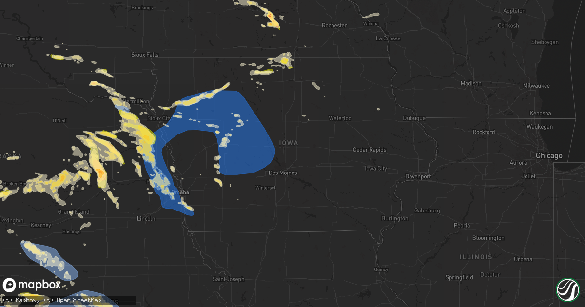
Hail Map in Iowa on June 16, 2025
Get this storm
June 16 map
$229
one time, instant access
Download today. No call, no setup
Keep the $229
Bought the map and want the full workflow? Apply the entire $229 to a subscription within 7 days. None of it is wasted.
Every map, not just this one
This buys you this map. Subscription and you get every map we run, in the markets you choose from a few cities to whole states to nationwide. Plus real-time alerts the moment a storm fires.
Contact data
Name, contact info, occupancy, even credit band for addresses in the footprint. You go from where it hit to who to call.
Become the source they trust
Unlimited branding weather history reports on demand. You already have the documented answer ready for the property owner, and you are the one who showed up with it.
Property data and RoofTrace estimates
Pull up any address you have got, its value and the exact code rules for that jurisdiction, straight from One Click Code. Then RoofTrace estimates the squares, pitch, and roof value, priced the way you price.
Storm reports in Iowa
Iowa
| Date | Description |
|---|---|
| 06/16/20256:14 PM CDT | Personal weather station. |
| 06/16/20255:48 PM CDT | Roof peeled off a building. Power outages throughout town. |
| 06/16/20255:47 PM CDT | Awos station kckp cherokee municipal airport. |
| 06/16/20255:47 PM CDT | Corrects previous tstm wnd gst report from 1 s cherokee. Awos station kckp cherokee municipal airport. |
| 06/16/20255:46 PM CDT | Several large limbs down. |
| 06/16/20255:37 PM CDT | Personal weather station. |
| 06/16/20255:34 PM CDT | Personal weather station. |
| 06/16/20255:33 PM CDT | A local report indicates 58 MPH wind near 4 W Correctionville |
| 06/16/20255:25 PM CDT | Multiple trees down in pierson. |
| 06/16/20255:10 PM CDT | Lots of branches knocked down in yard and house roof. Speed estimated at 70 mph... Due to moderate size of branches. |
| 06/16/20254:48 PM CDT | Power lines and several trees down near the intersection of k22 and c60. |
| 06/16/202510:00 AM CDT | Relayed through ema social media. |
| 06/15/20259:08 PM CDT | Strong wind gusts reported in atlantic... With medium to large sized tree branches down blocking multiple roads. Pea-sized hail was observed at times... With heavy rain |
| 06/15/20259:03 PM CDT | Personal weather station measured gust of 62 mph. |
| 06/15/20257:51 PM CDT | Personal weather station gusted to 60 mph. |
| 06/15/20257:09 PM CDT | Personal weather station gusted to 59 mph as the gust front moved through. |
All States Impacted by Hail Map on June 16, 2025
Cities Impacted by Hail Map on June 16, 2025
- Emmons, MN
- Alden, MN
- Pelican Rapids, MN
- Vergas, MN
- Albert Lea, MN
- Lake Mills, IA
- Scarville, IA
- Twin Lakes, MN
- Wells, MN
- Dent, MN
- Chaska, MN
- Cologne, MN
- Kiester, MN
- Northwood, IA
- Joice, IA
- Thompson, IA
- Appleton, MN
- Leland, IA
- Holloway, MN
- Bertha, MN
- Verndale, MN
- Willmar, MN
- Kandiyohi, MN
- Armstrong, IA
- Rockford, IA
- Lone Rock, IA
- Fenton, IA
- Dolliver, IA
- Marble Rock, IA
- Bancroft, IA
- Burt, IA
- Titonka, IA
- Swea City, IA
- Montgomery, MN
- Woden, IA
- Buffalo Center, IA
- Greene, IA
- Clarksville, IA
- Maple Lake, MN
- Annandale, MN
- Lu Verne, IA
- Forest City, IA
- Algona, IA
- Britt, IA
- Melrose, MN
- Freeport, MN
- Albany, MN
- Kanawha, IA
- Grey Eagle, MN
- Avon, MN
- Kimball, SD
- Saint Joseph, MN
- Sartell, MN
- Holdingford, MN
- Platte, SD
- White Lake, SD
- Saint Stephen, MN
- Excelsior, MN
- Stickney, SD
- Harrison, SD
- Corsica, SD
- Clearwater, MN
- South Haven, MN
- Kimball, MN
- Lumberton, MS
- Mound, MN
- Waite Park, MN
- Saint Cloud, MN
- Sauk Rapids, MN
- Iowa Falls, IA
- Monticello, MN
- Buffalo, MN
- Steamboat Rock, IA
- Erhard, MN
- Ackley, IA
- Mount Vernon, SD
- Long Lake, MN
- Wayzata, MN
- Hanover, MN
- Saint Michael, MN
- Loretto, MN
- Rockford, MN
- Houston, TX
- Rogers, MN
- Hamel, MN
- Salemburg, NC
- Edgewood, IA
- Strawberry Point, IA
- Kinston, NC
- Dover, NC
- Dimock, SD
- Parkston, SD
- Ethan, SD
- Minneapolis, MN
- Maple Plain, MN
- Tyndall, SD
- Scotland, SD
- Wilsall, MT
- Clinton, NC
- Osseo, MN
- Maple Grove, MN
- Avon, SD
- Plankinton, SD
- Maysville, NC
- Hopkins, MN
- Minnetonka, MN
- Kountze, TX
- Warren, TX
- Armour, SD
- Lesterville, SD
- Tabor, SD
- Turkey, NC
- Meridian, MS
- Yankton, SD
- Utica, SD
- Frederic, WI
- Havelock, NC
- Beaumont, TX
- Marion, MS
- Daleville, MS
- Lauderdale, MS
- Mission Hill, SD
- Crofton, NE
- Fordyce, NE
- Olivet, SD
- Tripp, SD
- Thermopolis, WY
- Gayville, SD
- Saint Helena, NE
- Menno, SD
- Shawmut, MT
- Melville, MT
- Livingston, MT
- Red Lodge, MT
- Hartington, NE
- Vermillion, SD
- Livingston, TX
- Ryegate, MT
- Big Timber, MT
- Coleridge, NE
- Laurel, NE
- Carbon Hill, AL
- Roberts, MT
- Wynot, NE
- Dixon, NE
- Newcastle, NE
- Belden, NE
- Carroll, NE
- Chinquapin, NC
- Motley, MN
- Pine River, MN
- Staples, MN
- Burbank, SD
- Pequot Lakes, MN
- Pillager, MN
- Randolph, NE
- Allen, NE
- Wayne, NE
- Concord, NE
- Wakefield, NE
- Osmond, NE
- Pierce, NE
- Scobey, MT
- Elk Point, SD
- Ponca, NE
- Nisswa, MN
- Richlands, NC
- Royal, NE
- Clearwater, NE
- Watkins, MN
- Jefferson, SD
- Brunswick, NE
- Neligh, NE
- Plainview, NE
- Bridger, MT
- Emerson, NE
- Broadview, MT
- Merrill, IA
- Hinton, IA
- Clarkson, NE
- Hubbard, NE
- Thurston, NE
- Howells, NE
- Wisner, NE
- Sioux City, IA
- Dakota City, NE
- South Sioux City, NE
- Beemer, NE
- Columbus, NE
- Bancroft, NE
- West Point, NE
- Pender, NE
- Dodge, NE
- Schuyler, NE
- Bellwood, NE
- Winnebago, NE
- Homer, NE
- Hayneville, AL
- Hull, TX
- Lavina, MT
- Westfield, IA
- Pilger, NE
- Autaugaville, AL
- Liberty, TX
- Jacksonville, NC
- Thomasville, NC
- Brainerd, MN
- Merrifield, MN
- Tilden, NE
- Cleveland, TX
- Austin, MN
- Reed Point, MT
- Maple Hill, NC
- Monticello, AR
- Carver, MN
- Crosby, MN
- Ironton, MN
- Moville, IA
- Waterbury, NE
- Fort Ripley, MN
- Baxter, MN
- Kingsley, IA
- Le Mars, IA
- Saratoga, TX
- Flaxville, MT
- Walthill, NE
- Dassel, MN
- Darwin, MN
- Pierce, CO
- Cokato, MN
- Nunn, CO
- Ault, CO
- Remsen, IA
- Rapelje, MT
- Meadow Grove, NE
- Deerwood, MN
- Pierson, IA
- Garrett, WY
- Sergeant Bluff, IA
- Salix, IA
- Pavillion, WY
- Acton, MT
- Rosalie, NE
- Hoskins, NE
- Eden Valley, MN
- Glenrock, WY
- Norfolk, NE
- Correctionville, IA
- Flagler, CO
- Molt, MT
- Aitkin, MN
- Garrison, MN
- Cleghorn, IA
- Meriden, IA
- Cherokee, IA
- Marcus, IA
- Silver Lake, MN
- Winsted, MN
- Bearcreek, MT
- Minot, ND
- Litchfield, MN
- Riverton, WY
- Sutherland, IA
- Larrabee, IA
- Peterson, IA
- Seibert, CO
- Casper, WY
- Bronson, IA
- Lawton, IA
- Hornick, IA
- Lyons, NE
- Macy, NE
- Sloan, IA
- Whiting, IA
- Climbing Hill, IA
- Battle Creek, IA
- Danbury, IA
- Holstein, IA
- Onawa, IA
- Decatur, NE
- Anthon, IA
- Quimby, IA
- Washta, IA
- Oto, IA
- Smithland, IA
- Cushing, IA
- Paullina, IA
- Aurelia, IA
- Howard Lake, MN
- Hillman, MN
- Pierz, MN
- Laurel, MT
- Park City, MT
- Jemison, AL
- Douglas, WY
- Stanton, NE
- Sleepy Eye, MN
- Shepherd, MT
- Billings, MT
- Isle, MN
- Eaton, CO
- Oakdale, NE
- Battle Creek, NE
- Winside, NE
- Glencoe, MN
- Brockton, MT
- Climax, NC
- Franklinville, NC
- Rodney, IA
- Tekamah, NE
- Mapleton, IA
- Castana, IA
- Albert City, IA
- Ida Grove, IA
- Schaller, IA
- Galva, IA
- Storm Lake, IA
- Rembrandt, IA
- Linn Grove, IA
- Truesdale, IA
- Alta, IA
- New Ulm, MN
- Gibbon, MN
- Velva, ND
- Norwich, ND
- Onamia, MN
- Wyola, MT
- Sioux Rapids, IA
- Webb, IA
- Waverly, MN
- McGrath, MN
- Huntley, MT
- Watertown, MN
- Fairfax, MN
- Lafayette, MN
- Greenville, IA
- Calera, AL
- Waverly, GA
- Fulshear, TX
- New Germany, MN
- Lester Prairie, MN
- Mayer, MN
- Richmond, TX
- White Oak, GA
- Sturgeon Lake, MN
- Foley, MN
- Young America, MN
- Woodbine, GA
- Winthrop, MN
- Finlayson, MN
- Shoshoni, WY
- Plato, MN
- Madison, NE
- Ballantine, MT
- Montrose, MN
- Delano, MN
- Lodge Grass, MT
- Ruthven, IA
- Ayrshire, IA
- Liberty, NC
- Odebolt, IA
- Arthur, IA
- Oakland, NE
- Hardin, MT
- Pompeys Pillar, MT
- Worden, MT
- Craig, NE
- Scribner, NE
- Hooper, NE
- Kiron, IA
- Nemaha, IA
- Lake View, IA
- Wall Lake, IA
- Early, IA
- Newell, IA
- Laurens, IA
- Varina, IA
- Curlew, IA
- Havelock, IA
- Pocahontas, IA
- Marathon, IA
- Fonda, IA
- Mallard, IA
- Sac City, IA
- Elgin, NE
- Petersburg, NE
- Bozeman, MT
- Voltaire, ND
- Nicollet, MN
- Gaylord, MN
- Foreston, MN
- Milaca, MN
- Oak Park, MN
- Waconia, MN
- McDonald, KS
- Herman, NE
- Nickerson, NE
- Kennard, NE
- Winslow, NE
- Arlington, NE
- Ames, NE
- Fremont, NE
- Uehling, NE
- Blair, NE
- Leigh, NE
- Newman Grove, NE
- Albion, NE
- Pomeroy, IA
- Norwood Young America, MN
- Lakota, IA
- Balfour, ND
- Ewing, NE
- Shakopee, MN
- Henderson, MN
- Green Isle, MN
- Breda, IA
- Mora, MN
- Auburn, IA
- Modale, IA
- Spring Park, MN
- Saint Francis, KS
- Palmer, IA
- Bridgeport, NE
- Mondamin, IA
- Redstone, MT
- Rockwell City, IA
- Lindsay, NE
- Lytton, IA
- Lake City, IA
- Manson, IA
- Jolley, IA
- Rolfe, IA
- Plover, IA
- Gilmore City, IA
- Valley, NE
- Cedar Bluffs, NE
- Bennington, NE
- Mead, NE
- Colon, NE
- Fort Calhoun, NE
- Yutan, NE
- Omaha, NE
- Washington, NE
- Elkhorn, NE
- Victoria, MN
- Chanhassen, MN
- Carroll, IA
- Rockford, AL
- Missouri Valley, IA
- Bird City, KS
- Arcadia, IA
- Saint Peter, MN
- Mankato, MN
- Parkman, WY
- Creston, NE
- Brook Park, MN
- Humphrey, NE
- Ranchester, WY
- Wellfleet, NE
- Belle Plaine, MN
- Eden Prairie, MN
- Kasota, MN
- Jordan, MN
- Somers, IA
- Manilla, IA
- Sheridan, WY
- North Platte, NE
- Waterloo, NE
- Saint Edward, NE
- Moorland, IA
- Farnhamville, IA
- Lohrville, IA
- Barnum, IA
- Knierim, IA
- Lehigh, IA
- Clare, IA
- Bradgate, IA
- Burnside, IA
- Humboldt, IA
- Gowrie, IA
- Callender, IA
- Fort Dodge, IA
- Otho, IA
- Churdan, IA
- Harcourt, IA
- Scranton, IA
- Glidden, IA
- Dedham, IA
- Westside, IA
- Manning, IA
- Templeton, IA
- Dayton, IA
- Halbur, IA
- Paton, IA
- Lanesboro, IA
- Audubon, IA
- Ralston, IA
- Lidderdale, IA
- Jefferson, IA
- Vail, IA
- Idalia, CO
- Brady, NE
- North Bend, NE
- Decker, MT
- Madison Lake, MN
- Bartlett, NE
- Rogers, NE
- Primrose, NE
- Saint Bonifacius, MN
- Eagle Lake, MN
- Janesville, MN
- Pemberton, MN
- Greeley, NE
- Gothenburg, NE
- Callaway, NE
- Good Thunder, MN
- Mapleton, MN
- Irwin, IA
- Ericson, NE
- Lake Crystal, MN
- Cedar Rapids, NE
- Genoa, NE
- Akron, CO
- Spalding, NE
- Cope, CO
- Prior Lake, MN
- La Vista, NE
- Papillion, NE
- Boys Town, NE
- Springfield, NE
- Gretna, NE
- Ashland, NE
- Bellevue, NE
- Monroe, NE
- Kimballton, IA
- Coon Rapids, IA
- Gray, IA
- Bayard, IA
- Dana, IA
- Beaver, IA
- Madrid, IA
- Perry, IA
- Jamaica, IA
- Pilot Mound, IA
- Stratford, IA
- Grand Junction, IA
- Ogden, IA
- Bagley, IA
- Rippey, IA
- Boone, IA
- Boxholm, IA
- Dickens, NE
- Mcclusky, ND
- Custer, SD
- Kirkman, IA
- Harlan, IA
- Scotia, NE
- Oconto, NE
- Clearmont, WY
- Wolbach, NE
- Rake, IA
- Lakeville, MN
- Council Bluffs, IA
- Elko New Market, MN
- Saint Clair, MN
- Cedar Creek, NE
- Louisville, NE
- South Bend, NE
- Plattsmouth, NE
- Woodward, IA
- Exira, IA
- Casey, IA
- Guthrie Center, IA
- Panora, IA
- Hamlin, IA
- Yale, IA
- Elk Horn, IA
- Dawson, IA
- Adair, IA
- Brayton, IA
- Menlo, IA
- Linden, IA
- Dallas Center, IA
- Stuart, IA
- Redfield, IA
- Bouton, IA
- Adel, IA
- Minburn, IA
- Luther, IA
- Granger, IA
- Silver Creek, NE
- Platte Center, NE
- Belgrade, NE
- Maywood, NE
- Hayes Center, NE
- Yuma, CO
- Shelby, IA
- Westerville, NE
- Arcadia, NE
- Stacy, MN
- Wyoming, MN
- Midwest, WY
- Offutt Afb, NE
- Wahoo, NE
- Minnesota Lake, MN
- North Loup, NE
- Bethel, MN
- Cedar, MN
- Fountain City, WI
- Minnesota City, MN
- Ord, NE
- Fullerton, NE
- Arvada, WY
- Eckley, CO
- Forest Lake, MN
- Chisago City, MN
- Regan, ND
- Gillette, WY
- Broken Bow, NE
- Hill City, SD
- Comstock, NE
- Arcadia, WI
- Rapid City, SD
- Pacific Junction, IA
- Loup City, NE
- Deadwood, SD
- Wing, ND
- Atwood, KS
- Ansley, NE
- Glenwood, IA
- Shelby, NE
- Marne, IA
- Newcastle, WY
- Elba, NE
- Scandia, MN
- Lead, SD
- Osceola, NE
- Selden, KS
- Ashton, NE
- Walnut, IA
- Wray, CO
- Nemo, SD
- Piedmont, SD
- Palmer, NE
- Atlantic, IA
- Mason City, NE
- Black Hawk, SD
- Malvern, IA
- Vernon, CO
- Saint Paul, NE
- Haigler, NE
- Ettrick, WI
- Cozad, NE
- Recluse, WY
- Murray, NE
- Tabor, IA
- Thurman, IA
- Sturgis, SD
- Sutherland, NE
- Merna, NE
- Arnold, NE
- Anselmo, NE
- Stromsburg, NE
- Gresham, NE
- Litchfield, NE
- Wallace, NE
- Rising City, NE
- Rockville, NE
- Benkelman, NE
- Wiota, IA
- Rozet, WY
- Weston, WY
- Hershey, NE
- Prescott, IA
- Tuttle, ND
- Bertrand, NE
- Melrose, WI
- Boelus, NE
- Farwell, NE
- Ulysses, NE
- Wauneta, NE
- Moorcroft, WY
- Dresden, KS
- Eustis, NE
- Dannebrog, NE
- Smithfield, NE
- Elwood, NE
- Surprise, NE
- Sparta, WI
- Steele, ND
- Palisade, NE
- Mindoro, WI
- Utica, NE
- Jennings, KS
- Atlanta, NE
- Holdrege, NE
- Grand Island, NE
- Cairo, NE
- Tryon, NE
- Alda, NE
- Saint Libory, NE
- Phillips, NE
- Aurora, NE
- Chapman, NE
- Maxwell, NE
- Giltner, NE
- Norwalk, WI
- Hoxie, KS
- Sundance, WY
- Devils Tower, WY
- Orleans, NE
- Harvard, NE
- Alma, NE
- Stapleton, NE
- Trumbull, NE
- Fairfield, NE
- Deweese, NE
- Upton, WY
- Republican City, NE
- Colby, KS
- Wilton, WI
- Wilcox, NE
- Naponee, NE
- Wheatland, WY
- Kendall, WI
- Bloomington, NE
- Stockton, KS
- Levant, KS
- Lexington, NE
- Elroy, WI
- Franklin, NE
- Oxford, NE
- Kensington, KS
- Hildreth, NE
- Riverton, NE
- Smith Center, KS
- Campbell, NE
- Inavale, NE
- Bladen, NE
- Upland, NE
- Woodston, KS
- Rexford, KS
- Morland, KS
- Red Cloud, NE
- Lebanon, KS
- Hill City, KS
- Gem, KS
- Alton, KS
- Oakley, KS
- Penokee, KS
- Brewster, KS
- Gaylord, KS
- Portis, KS
- Esbon, KS
- Lorimor, IA
- Mankato, KS
- Brewster, NE
- Natoma, KS
- Plainville, KS
- Cheyenne, WY
- Burr Oak, KS
- Guide Rock, NE
- Meriden, WY
- Taylor, NE
- Osborne, KS
- Bogue, KS
- Downs, KS
- Palco, KS
- Glen Elder, KS
- Tipton, KS
- Beloit, KS
- Yoder, WY
- Albin, WY
- Pine Bluffs, WY
- Paradise, KS
- Waldo, KS
- Harrisburg, NE
- Ellis, KS
- Catharine, KS
- Hays, KS
- Victoria, KS
- Russell, KS
- Quinter, KS
- Grinnell, KS
- Wakeeney, KS
- Park, KS
- Collyer, KS
- Grainfield, KS
- Ogallah, KS
- Gorham, KS
- Randall, KS
- Union Center, SD
- Elsie, NE
- Bushnell, NE
- Minatare, NE
- Simpson, KS
- Scottsbluff, NE
- Gering, NE
- Parks, NE
- Bunker Hill, KS
- Bayard, NE
- Hawk Springs, WY
- Glasco, KS
- Concordia, KS
- Barnard, KS
- Walker, KS
- Delphos, KS
- Lucas, KS
- McCracken, KS
- Bison, KS
- Liebenthal, KS
- Schoenchen, KS
- La Crosse, KS
- Luray, KS
- Brownell, KS
- Pfeifer, KS
- Sylvan Grove, KS
- Hunter, KS
- Jamestown, KS
- Minneapolis, KS
- Kimball, NE
- Max, NE
- Angora, NE
- Dorrance, KS
- Stratton, NE
- Lagrange, WY
- Otis, KS
- Lyman, NE
- Lincoln, KS
- Beverly, KS
- Tescott, KS
- Bennington, KS
- Aurora, KS
- Miltonvale, KS
- Hoisington, KS
- Rush Center, KS
- Olmitz, KS
- Wilson, KS
- Albert, KS
- Great Bend, KS
- Holyrood, KS
- Kanopolis, KS
- Salina, KS
- Lorraine, KS
- Brookville, KS
- Claflin, KS
- Ellsworth, KS
- Lakeside, NE
- Dix, NE
- Broadwater, NE
- Trenton, NE
- Solomon, KS
- New Cambria, KS
- Clay Center, KS
- Bushton, KS
- Longford, KS
- Enders, NE
- Pawnee Rock, KS
- Ellinwood, KS
- Larned, KS
- St John, KS
- Chase, KS
- Geneseo, KS
- Hudson, KS
- Marquette, KS
- Lyons, KS
- Raymond, KS
- Abilene, KS
- Falun, KS
- Assaria, KS
- Talmage, KS
- Gypsum, KS
- Little River, KS
- Lindsborg, KS
- Fort Collins, CO
- Herndon, KS
- Medicine Bow, WY
- Oberlin, KS
- Lisco, NE
- Windsor, CO
- Severance, CO
- Wellington, CO
- Greeley, CO
- Lucerne, CO
- Potter, NE
- Sterling, KS
- Inman, KS
- Partridge, KS
- Sylvia, KS
- Turon, KS
- Plevna, KS
- Abbyville, KS
- Cunningham, KS
- Arlington, KS
- Mcpherson, KS
- Windom, KS
- Alden, KS
- Nickerson, KS
- Hutchinson, KS
- Stafford, KS
- Fe Warren Afb, WY
- Damar, KS
- Enterprise, KS
- Wakefield, KS
- Woodbine, KS
- Chapman, KS
- Junction City, KS
- Milford, KS
- Kingman, KS
- South Hutchinson, KS
- Pretty Prairie, KS
- Haven, KS
- Roxbury, KS
- Burrton, KS
- Moundridge, KS
- Buhler, KS
- Canton, KS
- Galva, KS
- Carr, CO
- Gill, CO
- Gurley, NE
- Dalton, NE
- Spivey, KS
- Murdock, KS
- Cheney, KS
- Lehigh, KS
- Valley Center, KS
- Halstead, KS
- Sedgwick, KS
- Bentley, KS
- Maize, KS
- Andale, KS
- Goddard, KS
- Wichita, KS
- Garden Plain, KS
- Mount Hope, KS
- Colwich, KS
- Briggsdale, CO
- Johnstown, CO
- Loveland, CO
- Norwich, KS
- Argonia, KS
- Milton, KS
- Hesston, KS
- Peabody, KS
- Newton, KS
- North Newton, KS
- Viola, KS
- Walton, KS
- Goessel, KS
- Hillsboro, KS
- Clearwater, KS
- Milliken, CO
- Sidney, NE
- Kersey, CO
- Orchard, CO
- Zenda, KS
- Evans, CO
- Wiggins, CO
- Harper, KS
- Conway Springs, KS
- Milan, KS
- Whitewater, KS
- Marion, KS
- Mayfield, KS
- Kechi, KS
- Greenwich, KS
- Belle Plaine, KS
- Mcconnell Afb, KS
- Peck, KS
- Derby, KS
- Haysville, KS
- Wellington, KS
- Weldona, CO
- La Salle, CO
- Gilcrest, CO
- Platteville, CO
- Fort Morgan, CO
- Freeport, KS
- Danville, KS
- Florence, KS
- Elbing, KS
- Andover, KS
- Towanda, KS
- El Dorado, KS
- Potwin, KS
- Benton, KS
- Burns, KS
- Rose Hill, KS
- Mulvane, KS
- Douglass, KS
- Udall, KS
- Hudson, CO
- Brighton, CO
- Lafayette, CO
- Longmont, CO
- Timnath, CO
- Keenesburg, CO
- Anthony, KS
- Broomfield, CO
- Denver, CO
- Thornton, CO
- Erie, CO
- Bennett, CO
- Snyder, CO
- Caldwell, KS
- Oxford, KS
- South Haven, KS
- Log Lane Village, CO
- Geuda Springs, KS
- Bluff City, KS
- Henderson, CO
- Augusta, KS
- Medford, OK
- Atlanta, KS
- Winfield, KS
- Rock, KS
- Leon, KS
- Arkansas City, KS
- Braman, OK
- Newkirk, OK
- Burden, KS
- Nardin, OK
- Deer Creek, OK
- Lamont, OK
- Dexter, KS
- Ponca City, OK
- Blackwell, OK
- Tonkawa, OK
- Commerce City, CO
- Brush, CO
- Strasburg, CO
- Fort Lupton, CO
- Aurora, CO
- Marland, OK
- Red Rock, OK
- Maple City, KS
- Kaw City, OK
- Irene, SD
- Byers, CO
- Watkins, CO
- Elmore, MN
- Ralston, OK
- Mitchell, NE
- Perry, OK
- Billings, OK
- Pawnee, OK
- Morrison, OK
- Stillwater, OK
- Glencoe, OK
- Ripley, OK
- Perkins, OK
- Yale, OK
- Parker, CO
- Otis, CO
- Berthoud, CO
- Henning, MN
- Perham, MN


