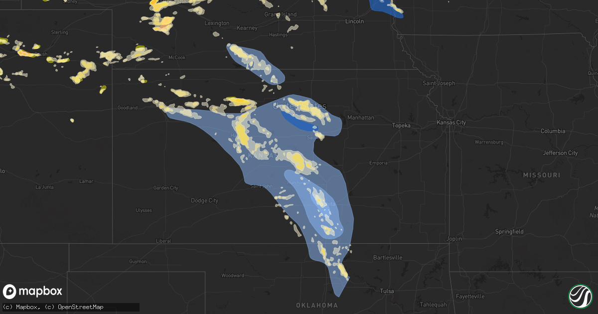
Hail Map in Kansas on June 16, 2025
Get this storm
June 16 map
$229
one time, instant access
Download today. No call, no setup
Keep the $229
Bought the map and want the full workflow? Apply the entire $229 to a subscription within 7 days. None of it is wasted.
Every map, not just this one
This buys you this map. Subscription and you get every map we run, in the markets you choose from a few cities to whole states to nationwide. Plus real-time alerts the moment a storm fires.
Contact data
Name, contact info, occupancy, even credit band for addresses in the footprint. You go from where it hit to who to call.
Become the source they trust
Unlimited branding weather history reports on demand. You already have the documented answer ready for the property owner, and you are the one who showed up with it.
Property data and RoofTrace estimates
Pull up any address you have got, its value and the exact code rules for that jurisdiction, straight from One Click Code. Then RoofTrace estimates the squares, pitch, and roof value, priced the way you price.
Storm reports in Kansas
Kansas
| Date | Description |
|---|---|
| 06/16/20256:55 PM CDT | Nickel to quarter sized hail ongoing over a duration of 10 minutes. |
| 06/16/202512:40 PM CDT | Up846 reported the gust. |
| 06/16/20255:48 AM CDT | A local report indicates 60 MPH wind near Arkansas City |
| 06/16/20255:44 AM CDT | Power outages reported in winfield. |
| 06/16/20255:40 AM CDT | Estimated 4 foot d |
| 06/16/20255:40 AM CDT | Estimated 4 foot diameter cottonwood tree fell onto powerline which has since snapped that pole. |
| 06/16/20255:40 AM CDT | Estimated 4 foot diameter cottonwood tree fell onto powerline which has since snapped that p |
| 06/16/20255:35 AM CDT | Reported at kwld. |
| 06/16/20255:31 AM CDT | Asos station kwld strother field airport. |
| 06/16/20255:07 AM CDT | A local report indicates 60 MPH wind near 1 NW Udall |
| 06/16/20254:56 AM CDT | A local report indicates 62 MPH wind near Benton |
| 06/16/20254:55 AM CDT | Two power poles snapped off. Time estimated from radar. |
| 06/16/20254:55 AM CDT | Awos station kbec beech factory airport. |
| 06/16/20254:55 AM CDT | Awos station kiab mcconnell afb. |
| 06/16/20254:54 AM CDT | Street light blocking road in the 600 block of e. 36th in newton. |
| 06/16/20254:53 AM CDT | Several power lines down across wichita metro. |
| 06/16/20254:46 AM CDT | Large tree down across burmac and 84th road. |
| 06/16/20254:42 AM CDT | Reported large tree fell on homes and a person was stuck inside home at 1200 block s pershing. No injuries. |
| 06/16/20254:41 AM CDT | Several large 3 inch diameter tree branches down. Power pole leaning over roadway. Time estimated from radar. |
| 06/16/20254:37 AM CDT | A local report indicates 80 MPH wind near 1 WNW East Wichita |
| 06/16/20254:36 AM CDT | Power line down at east 4th street. |
| 06/16/20254:35 AM CDT | Awos station kaao 2 ese bel aire. |
| 06/16/20254:35 AM CDT | A local report indicates 80 MPH wind near Conway Springs |
| 06/16/20254:34 AM CDT | A local report indicates 85 MPH wind near Jabara Airport |
| 06/16/20254:24 AM CDT | Mesonet station up317 0.8 w canton |
| 06/16/20254:22 AM CDT | Reported at kict. |
| 06/16/20254:08 AM CDT | Large tree down at sw 96th and burmac road. |
| 06/16/20254:00 AM CDT | Large tree down. |
| 06/16/20253:57 AM CDT | At least 70 mph estimated. |
| 06/16/20253:55 AM CDT | Measured at the mcpherson airport. |
| 06/16/20253:54 AM CDT | At least 80 mph in the city of mount hope. |
| 06/16/20253:53 AM CDT | A local report indicates 70 MPH wind near Mount Hope |
| 06/16/20253:38 AM CDT | Wind gusts between 70 to 80 mph estimated. |
| 06/16/20253:31 AM CDT | Asos station khut hutchinson municipal airport. |
| 06/16/20253:30 AM CDT | Spotter estimated 70-80 mph wind gusts. Very heavy rainfall as well. |
| 06/16/20253:03 AM CDT | Reports of trees down |
| 06/16/20253:02 AM CDT | Report from kansas mesonet. |
| 06/16/20252:55 AM CDT | Awos station klyo lyons rice co. Municipal airpt. |
| 06/16/20252:45 AM CDT | Via social media. Delayed report. Downed tree of unknown diameter. Power is also out. |
| 06/16/20252:34 AM CDT | A local report indicates 62 MPH wind near 3 N New Cambria |
| 06/16/20252:32 AM CDT | Mesonet station ur445 3.2 e new cambria |
| 06/16/20252:32 AM CDT | A 7-inch diameter dead tree branch broken off and on the ground. This report received from social media. |
| 06/16/20252:25 AM CDT | Reported by the kansas state mesonet. |
| 06/16/20252:23 AM CDT | Report received from the kansas state mesonet. |
| 06/16/20252:21 AM CDT | Personal weather station. |
| 06/16/20252:14 AM CDT | Time estimated radar. 4 inch diameter tree limb over road. Delayed report. |
| 06/16/20252:14 AM CDT | Personal weather station. |
| 06/16/20252:12 AM CDT | A local report indicates 58 MPH wind near 3 NE Pawnee Rock |
| 06/16/20252:10 AM CDT | A local report indicates 70 MPH wind near 6 N Wells |
| 06/16/20252:05 AM CDT | Delayed report. |
| 06/16/20252:05 AM CDT | Delayed report. |
| 06/16/20251:49 AM CDT | Personal weather station. |
| 06/16/20251:34 AM CDT | Asos station krsl russell municipal airport. |
| 06/16/20251:25 AM CDT | Asos station krsl russell municipal airport. |
| 06/16/20251:25 AM CDT | Spotter also lost power with the strong winds. |
| 06/16/20251:22 AM CDT | Personal weather station. Delayed report. |
| 06/16/20251:18 AM CDT | Ksu mesonet. |
| 06/16/20251:01 AM CDT | A local report indicates 72 MPH wind near 9 NNE Yocemento |
| 06/16/202512:57 AM CDT | A local report indicates 59 MPH wind near 9 NNE Ellis |
| 06/16/202512:50 AM CDT | A local report indicates 60 MPH wind near Hunter |
| 06/16/202512:48 AM CDT | Ksu mesonet. |
| 06/16/202512:36 AM CDT | Mesonet station up846 2.0 e quinter |
| 06/15/202511:40 PM CDT | Dispatch reports a few stones up to 1 inch diameter... Most smaller. |
| 06/15/202511:28 PM CDT | Delayed report. Relayed through em. |
| 06/15/202510:38 PM CDT | Pws-kksnorca2. |
| 06/15/202510:34 PM CDT | Corrects previous tstm wnd gst report from 3 nw calvert. Awn geil lodge gust. |
| 06/15/202510:21 PM CDT | Delayed report. Trained spotter found additional 12 inch green tree limb down the next morning. |
| 06/15/202510:21 PM CDT | Spotter reported multiple 8 inch green tree limbs blown roughly 300-350 feet to the north from the trees. Also reported numerous 3-5 inch tree limbs on the ground as we |
| 06/15/202510:16 PM CDT | Public report of 60 mph winds and blowing dust with visibility near 0. |
| 06/15/202510:16 PM CDT | Public report of 60 mph winds and blowing dust with visibility near 0. |
| 06/15/202510:15 PM CDT | Ksyf reported the wind gust. |
| 06/15/202510:15 PM CDT | Awos station koin oberlin. |
| 06/15/202510:00 PM CDT | Social media report with pictures of damage to an out building and a tree limb down from the winds. |
| 06/15/20259:56 PM CDT | A local report indicates 60 MPH wind near 7 SSE Norton |
| 06/15/20259:55 PM CDT | Awos station koin oberlin. |
| 06/15/20259:33 PM CDT | Report of brick car wash collapsing from winds. |
| 06/15/20259:15 PM CDT | A local report indicates 58 MPH wind near 4 N Ludell |
| 06/15/20259:15 PM CDT | Awos station ksyf st. Francis city. |
| 06/15/20258:55 PM CDT | A local report indicates 60 MPH wind near 8 SSE Bird City |
| 06/15/20258:54 PM CDT | Spotter estimated 70 to 80 mph winds with blowing dust creating visibility reductions of 1/8 to 1/2 half mile. |
| 06/15/20258:53 PM CDT | A local report indicates 58 MPH wind near 4 WNW Bird City |
| 06/15/20258:43 PM CDT | Awos station ksyf st. Francis city. |
| 06/15/20258:40 PM CDT | Winds estimated and coming out of the southeast. |
| 06/15/20258:40 PM CDT | Estimated 70-80 mph winds off and on. |
| 06/15/20258:21 PM CDT | Reported via ks mesonet cheyenne station. |
| 06/15/20257:55 PM CDT | Reported via weatherunderground station kkskanor6. |
All States Impacted by Hail Map on June 16, 2025
Cities Impacted by Hail Map on June 16, 2025
- Emmons, MN
- Alden, MN
- Pelican Rapids, MN
- Vergas, MN
- Albert Lea, MN
- Lake Mills, IA
- Scarville, IA
- Twin Lakes, MN
- Wells, MN
- Dent, MN
- Chaska, MN
- Cologne, MN
- Kiester, MN
- Northwood, IA
- Joice, IA
- Thompson, IA
- Appleton, MN
- Leland, IA
- Holloway, MN
- Bertha, MN
- Verndale, MN
- Willmar, MN
- Kandiyohi, MN
- Armstrong, IA
- Rockford, IA
- Lone Rock, IA
- Fenton, IA
- Dolliver, IA
- Marble Rock, IA
- Bancroft, IA
- Burt, IA
- Titonka, IA
- Swea City, IA
- Montgomery, MN
- Woden, IA
- Buffalo Center, IA
- Greene, IA
- Clarksville, IA
- Maple Lake, MN
- Annandale, MN
- Lu Verne, IA
- Forest City, IA
- Algona, IA
- Britt, IA
- Melrose, MN
- Freeport, MN
- Albany, MN
- Kanawha, IA
- Grey Eagle, MN
- Avon, MN
- Kimball, SD
- Saint Joseph, MN
- Sartell, MN
- Holdingford, MN
- Platte, SD
- White Lake, SD
- Saint Stephen, MN
- Excelsior, MN
- Stickney, SD
- Harrison, SD
- Corsica, SD
- Clearwater, MN
- South Haven, MN
- Kimball, MN
- Lumberton, MS
- Mound, MN
- Waite Park, MN
- Saint Cloud, MN
- Sauk Rapids, MN
- Iowa Falls, IA
- Monticello, MN
- Buffalo, MN
- Steamboat Rock, IA
- Erhard, MN
- Ackley, IA
- Mount Vernon, SD
- Long Lake, MN
- Wayzata, MN
- Hanover, MN
- Saint Michael, MN
- Loretto, MN
- Rockford, MN
- Houston, TX
- Rogers, MN
- Hamel, MN
- Salemburg, NC
- Edgewood, IA
- Strawberry Point, IA
- Kinston, NC
- Dover, NC
- Dimock, SD
- Parkston, SD
- Ethan, SD
- Minneapolis, MN
- Maple Plain, MN
- Tyndall, SD
- Scotland, SD
- Wilsall, MT
- Clinton, NC
- Osseo, MN
- Maple Grove, MN
- Avon, SD
- Plankinton, SD
- Maysville, NC
- Hopkins, MN
- Minnetonka, MN
- Kountze, TX
- Warren, TX
- Armour, SD
- Lesterville, SD
- Tabor, SD
- Turkey, NC
- Meridian, MS
- Yankton, SD
- Utica, SD
- Frederic, WI
- Havelock, NC
- Beaumont, TX
- Marion, MS
- Daleville, MS
- Lauderdale, MS
- Mission Hill, SD
- Crofton, NE
- Fordyce, NE
- Olivet, SD
- Tripp, SD
- Thermopolis, WY
- Gayville, SD
- Saint Helena, NE
- Menno, SD
- Shawmut, MT
- Melville, MT
- Livingston, MT
- Red Lodge, MT
- Hartington, NE
- Vermillion, SD
- Livingston, TX
- Ryegate, MT
- Big Timber, MT
- Coleridge, NE
- Laurel, NE
- Carbon Hill, AL
- Roberts, MT
- Wynot, NE
- Dixon, NE
- Newcastle, NE
- Belden, NE
- Carroll, NE
- Chinquapin, NC
- Motley, MN
- Pine River, MN
- Staples, MN
- Burbank, SD
- Pequot Lakes, MN
- Pillager, MN
- Randolph, NE
- Allen, NE
- Wayne, NE
- Concord, NE
- Wakefield, NE
- Osmond, NE
- Pierce, NE
- Scobey, MT
- Elk Point, SD
- Ponca, NE
- Nisswa, MN
- Richlands, NC
- Royal, NE
- Clearwater, NE
- Watkins, MN
- Jefferson, SD
- Brunswick, NE
- Neligh, NE
- Plainview, NE
- Bridger, MT
- Emerson, NE
- Broadview, MT
- Merrill, IA
- Hinton, IA
- Clarkson, NE
- Hubbard, NE
- Thurston, NE
- Howells, NE
- Wisner, NE
- Sioux City, IA
- Dakota City, NE
- South Sioux City, NE
- Beemer, NE
- Columbus, NE
- Bancroft, NE
- West Point, NE
- Pender, NE
- Dodge, NE
- Schuyler, NE
- Bellwood, NE
- Winnebago, NE
- Homer, NE
- Hayneville, AL
- Hull, TX
- Lavina, MT
- Westfield, IA
- Pilger, NE
- Autaugaville, AL
- Liberty, TX
- Jacksonville, NC
- Thomasville, NC
- Brainerd, MN
- Merrifield, MN
- Tilden, NE
- Cleveland, TX
- Austin, MN
- Reed Point, MT
- Maple Hill, NC
- Monticello, AR
- Carver, MN
- Crosby, MN
- Ironton, MN
- Moville, IA
- Waterbury, NE
- Fort Ripley, MN
- Baxter, MN
- Kingsley, IA
- Le Mars, IA
- Saratoga, TX
- Flaxville, MT
- Walthill, NE
- Dassel, MN
- Darwin, MN
- Pierce, CO
- Cokato, MN
- Nunn, CO
- Ault, CO
- Remsen, IA
- Rapelje, MT
- Meadow Grove, NE
- Deerwood, MN
- Pierson, IA
- Garrett, WY
- Sergeant Bluff, IA
- Salix, IA
- Pavillion, WY
- Acton, MT
- Rosalie, NE
- Hoskins, NE
- Eden Valley, MN
- Glenrock, WY
- Norfolk, NE
- Correctionville, IA
- Flagler, CO
- Molt, MT
- Aitkin, MN
- Garrison, MN
- Cleghorn, IA
- Meriden, IA
- Cherokee, IA
- Marcus, IA
- Silver Lake, MN
- Winsted, MN
- Bearcreek, MT
- Minot, ND
- Litchfield, MN
- Riverton, WY
- Sutherland, IA
- Larrabee, IA
- Peterson, IA
- Seibert, CO
- Casper, WY
- Bronson, IA
- Lawton, IA
- Hornick, IA
- Lyons, NE
- Macy, NE
- Sloan, IA
- Whiting, IA
- Climbing Hill, IA
- Battle Creek, IA
- Danbury, IA
- Holstein, IA
- Onawa, IA
- Decatur, NE
- Anthon, IA
- Quimby, IA
- Washta, IA
- Oto, IA
- Smithland, IA
- Cushing, IA
- Paullina, IA
- Aurelia, IA
- Howard Lake, MN
- Hillman, MN
- Pierz, MN
- Laurel, MT
- Park City, MT
- Jemison, AL
- Douglas, WY
- Stanton, NE
- Sleepy Eye, MN
- Shepherd, MT
- Billings, MT
- Isle, MN
- Eaton, CO
- Oakdale, NE
- Battle Creek, NE
- Winside, NE
- Glencoe, MN
- Brockton, MT
- Climax, NC
- Franklinville, NC
- Rodney, IA
- Tekamah, NE
- Mapleton, IA
- Castana, IA
- Albert City, IA
- Ida Grove, IA
- Schaller, IA
- Galva, IA
- Storm Lake, IA
- Rembrandt, IA
- Linn Grove, IA
- Truesdale, IA
- Alta, IA
- New Ulm, MN
- Gibbon, MN
- Velva, ND
- Norwich, ND
- Onamia, MN
- Wyola, MT
- Sioux Rapids, IA
- Webb, IA
- Waverly, MN
- McGrath, MN
- Huntley, MT
- Watertown, MN
- Fairfax, MN
- Lafayette, MN
- Greenville, IA
- Calera, AL
- Waverly, GA
- Fulshear, TX
- New Germany, MN
- Lester Prairie, MN
- Mayer, MN
- Richmond, TX
- White Oak, GA
- Sturgeon Lake, MN
- Foley, MN
- Young America, MN
- Woodbine, GA
- Winthrop, MN
- Finlayson, MN
- Shoshoni, WY
- Plato, MN
- Madison, NE
- Ballantine, MT
- Montrose, MN
- Delano, MN
- Lodge Grass, MT
- Ruthven, IA
- Ayrshire, IA
- Liberty, NC
- Odebolt, IA
- Arthur, IA
- Oakland, NE
- Hardin, MT
- Pompeys Pillar, MT
- Worden, MT
- Craig, NE
- Scribner, NE
- Hooper, NE
- Kiron, IA
- Nemaha, IA
- Lake View, IA
- Wall Lake, IA
- Early, IA
- Newell, IA
- Laurens, IA
- Varina, IA
- Curlew, IA
- Havelock, IA
- Pocahontas, IA
- Marathon, IA
- Fonda, IA
- Mallard, IA
- Sac City, IA
- Elgin, NE
- Petersburg, NE
- Bozeman, MT
- Voltaire, ND
- Nicollet, MN
- Gaylord, MN
- Foreston, MN
- Milaca, MN
- Oak Park, MN
- Waconia, MN
- McDonald, KS
- Herman, NE
- Nickerson, NE
- Kennard, NE
- Winslow, NE
- Arlington, NE
- Ames, NE
- Fremont, NE
- Uehling, NE
- Blair, NE
- Leigh, NE
- Newman Grove, NE
- Albion, NE
- Pomeroy, IA
- Norwood Young America, MN
- Lakota, IA
- Balfour, ND
- Ewing, NE
- Shakopee, MN
- Henderson, MN
- Green Isle, MN
- Breda, IA
- Mora, MN
- Auburn, IA
- Modale, IA
- Spring Park, MN
- Saint Francis, KS
- Palmer, IA
- Bridgeport, NE
- Mondamin, IA
- Redstone, MT
- Rockwell City, IA
- Lindsay, NE
- Lytton, IA
- Lake City, IA
- Manson, IA
- Jolley, IA
- Rolfe, IA
- Plover, IA
- Gilmore City, IA
- Valley, NE
- Cedar Bluffs, NE
- Bennington, NE
- Mead, NE
- Colon, NE
- Fort Calhoun, NE
- Yutan, NE
- Omaha, NE
- Washington, NE
- Elkhorn, NE
- Victoria, MN
- Chanhassen, MN
- Carroll, IA
- Rockford, AL
- Missouri Valley, IA
- Bird City, KS
- Arcadia, IA
- Saint Peter, MN
- Mankato, MN
- Parkman, WY
- Creston, NE
- Brook Park, MN
- Humphrey, NE
- Ranchester, WY
- Wellfleet, NE
- Belle Plaine, MN
- Eden Prairie, MN
- Kasota, MN
- Jordan, MN
- Somers, IA
- Manilla, IA
- Sheridan, WY
- North Platte, NE
- Waterloo, NE
- Saint Edward, NE
- Moorland, IA
- Farnhamville, IA
- Lohrville, IA
- Barnum, IA
- Knierim, IA
- Lehigh, IA
- Clare, IA
- Bradgate, IA
- Burnside, IA
- Humboldt, IA
- Gowrie, IA
- Callender, IA
- Fort Dodge, IA
- Otho, IA
- Churdan, IA
- Harcourt, IA
- Scranton, IA
- Glidden, IA
- Dedham, IA
- Westside, IA
- Manning, IA
- Templeton, IA
- Dayton, IA
- Halbur, IA
- Paton, IA
- Lanesboro, IA
- Audubon, IA
- Ralston, IA
- Lidderdale, IA
- Jefferson, IA
- Vail, IA
- Idalia, CO
- Brady, NE
- North Bend, NE
- Decker, MT
- Madison Lake, MN
- Bartlett, NE
- Rogers, NE
- Primrose, NE
- Saint Bonifacius, MN
- Eagle Lake, MN
- Janesville, MN
- Pemberton, MN
- Greeley, NE
- Gothenburg, NE
- Callaway, NE
- Good Thunder, MN
- Mapleton, MN
- Irwin, IA
- Ericson, NE
- Lake Crystal, MN
- Cedar Rapids, NE
- Genoa, NE
- Akron, CO
- Spalding, NE
- Cope, CO
- Prior Lake, MN
- La Vista, NE
- Papillion, NE
- Boys Town, NE
- Springfield, NE
- Gretna, NE
- Ashland, NE
- Bellevue, NE
- Monroe, NE
- Kimballton, IA
- Coon Rapids, IA
- Gray, IA
- Bayard, IA
- Dana, IA
- Beaver, IA
- Madrid, IA
- Perry, IA
- Jamaica, IA
- Pilot Mound, IA
- Stratford, IA
- Grand Junction, IA
- Ogden, IA
- Bagley, IA
- Rippey, IA
- Boone, IA
- Boxholm, IA
- Dickens, NE
- Mcclusky, ND
- Custer, SD
- Kirkman, IA
- Harlan, IA
- Scotia, NE
- Oconto, NE
- Clearmont, WY
- Wolbach, NE
- Rake, IA
- Lakeville, MN
- Council Bluffs, IA
- Elko New Market, MN
- Saint Clair, MN
- Cedar Creek, NE
- Louisville, NE
- South Bend, NE
- Plattsmouth, NE
- Woodward, IA
- Exira, IA
- Casey, IA
- Guthrie Center, IA
- Panora, IA
- Hamlin, IA
- Yale, IA
- Elk Horn, IA
- Dawson, IA
- Adair, IA
- Brayton, IA
- Menlo, IA
- Linden, IA
- Dallas Center, IA
- Stuart, IA
- Redfield, IA
- Bouton, IA
- Adel, IA
- Minburn, IA
- Luther, IA
- Granger, IA
- Silver Creek, NE
- Platte Center, NE
- Belgrade, NE
- Maywood, NE
- Hayes Center, NE
- Yuma, CO
- Shelby, IA
- Westerville, NE
- Arcadia, NE
- Stacy, MN
- Wyoming, MN
- Midwest, WY
- Offutt Afb, NE
- Wahoo, NE
- Minnesota Lake, MN
- North Loup, NE
- Bethel, MN
- Cedar, MN
- Fountain City, WI
- Minnesota City, MN
- Ord, NE
- Fullerton, NE
- Arvada, WY
- Eckley, CO
- Forest Lake, MN
- Chisago City, MN
- Regan, ND
- Gillette, WY
- Broken Bow, NE
- Hill City, SD
- Comstock, NE
- Arcadia, WI
- Rapid City, SD
- Pacific Junction, IA
- Loup City, NE
- Deadwood, SD
- Wing, ND
- Atwood, KS
- Ansley, NE
- Glenwood, IA
- Shelby, NE
- Marne, IA
- Newcastle, WY
- Elba, NE
- Scandia, MN
- Lead, SD
- Osceola, NE
- Selden, KS
- Ashton, NE
- Walnut, IA
- Wray, CO
- Nemo, SD
- Piedmont, SD
- Palmer, NE
- Atlantic, IA
- Mason City, NE
- Black Hawk, SD
- Malvern, IA
- Vernon, CO
- Saint Paul, NE
- Haigler, NE
- Ettrick, WI
- Cozad, NE
- Recluse, WY
- Murray, NE
- Tabor, IA
- Thurman, IA
- Sturgis, SD
- Sutherland, NE
- Merna, NE
- Arnold, NE
- Anselmo, NE
- Stromsburg, NE
- Gresham, NE
- Litchfield, NE
- Wallace, NE
- Rising City, NE
- Rockville, NE
- Benkelman, NE
- Wiota, IA
- Rozet, WY
- Weston, WY
- Hershey, NE
- Prescott, IA
- Tuttle, ND
- Bertrand, NE
- Melrose, WI
- Boelus, NE
- Farwell, NE
- Ulysses, NE
- Wauneta, NE
- Moorcroft, WY
- Dresden, KS
- Eustis, NE
- Dannebrog, NE
- Smithfield, NE
- Elwood, NE
- Surprise, NE
- Sparta, WI
- Steele, ND
- Palisade, NE
- Mindoro, WI
- Utica, NE
- Jennings, KS
- Atlanta, NE
- Holdrege, NE
- Grand Island, NE
- Cairo, NE
- Tryon, NE
- Alda, NE
- Saint Libory, NE
- Phillips, NE
- Aurora, NE
- Chapman, NE
- Maxwell, NE
- Giltner, NE
- Norwalk, WI
- Hoxie, KS
- Sundance, WY
- Devils Tower, WY
- Orleans, NE
- Harvard, NE
- Alma, NE
- Stapleton, NE
- Trumbull, NE
- Fairfield, NE
- Deweese, NE
- Upton, WY
- Republican City, NE
- Colby, KS
- Wilton, WI
- Wilcox, NE
- Naponee, NE
- Wheatland, WY
- Kendall, WI
- Bloomington, NE
- Stockton, KS
- Levant, KS
- Lexington, NE
- Elroy, WI
- Franklin, NE
- Oxford, NE
- Kensington, KS
- Hildreth, NE
- Riverton, NE
- Smith Center, KS
- Campbell, NE
- Inavale, NE
- Bladen, NE
- Upland, NE
- Woodston, KS
- Rexford, KS
- Morland, KS
- Red Cloud, NE
- Lebanon, KS
- Hill City, KS
- Gem, KS
- Alton, KS
- Oakley, KS
- Penokee, KS
- Brewster, KS
- Gaylord, KS
- Portis, KS
- Esbon, KS
- Lorimor, IA
- Mankato, KS
- Brewster, NE
- Natoma, KS
- Plainville, KS
- Cheyenne, WY
- Burr Oak, KS
- Guide Rock, NE
- Meriden, WY
- Taylor, NE
- Osborne, KS
- Bogue, KS
- Downs, KS
- Palco, KS
- Glen Elder, KS
- Tipton, KS
- Beloit, KS
- Yoder, WY
- Albin, WY
- Pine Bluffs, WY
- Paradise, KS
- Waldo, KS
- Harrisburg, NE
- Ellis, KS
- Catharine, KS
- Hays, KS
- Victoria, KS
- Russell, KS
- Quinter, KS
- Grinnell, KS
- Wakeeney, KS
- Park, KS
- Collyer, KS
- Grainfield, KS
- Ogallah, KS
- Gorham, KS
- Randall, KS
- Union Center, SD
- Elsie, NE
- Bushnell, NE
- Minatare, NE
- Simpson, KS
- Scottsbluff, NE
- Gering, NE
- Parks, NE
- Bunker Hill, KS
- Bayard, NE
- Hawk Springs, WY
- Glasco, KS
- Concordia, KS
- Barnard, KS
- Walker, KS
- Delphos, KS
- Lucas, KS
- McCracken, KS
- Bison, KS
- Liebenthal, KS
- Schoenchen, KS
- La Crosse, KS
- Luray, KS
- Brownell, KS
- Pfeifer, KS
- Sylvan Grove, KS
- Hunter, KS
- Jamestown, KS
- Minneapolis, KS
- Kimball, NE
- Max, NE
- Angora, NE
- Dorrance, KS
- Stratton, NE
- Lagrange, WY
- Otis, KS
- Lyman, NE
- Lincoln, KS
- Beverly, KS
- Tescott, KS
- Bennington, KS
- Aurora, KS
- Miltonvale, KS
- Hoisington, KS
- Rush Center, KS
- Olmitz, KS
- Wilson, KS
- Albert, KS
- Great Bend, KS
- Holyrood, KS
- Kanopolis, KS
- Salina, KS
- Lorraine, KS
- Brookville, KS
- Claflin, KS
- Ellsworth, KS
- Lakeside, NE
- Dix, NE
- Broadwater, NE
- Trenton, NE
- Solomon, KS
- New Cambria, KS
- Clay Center, KS
- Bushton, KS
- Longford, KS
- Enders, NE
- Pawnee Rock, KS
- Ellinwood, KS
- Larned, KS
- St John, KS
- Chase, KS
- Geneseo, KS
- Hudson, KS
- Marquette, KS
- Lyons, KS
- Raymond, KS
- Abilene, KS
- Falun, KS
- Assaria, KS
- Talmage, KS
- Gypsum, KS
- Little River, KS
- Lindsborg, KS
- Fort Collins, CO
- Herndon, KS
- Medicine Bow, WY
- Oberlin, KS
- Lisco, NE
- Windsor, CO
- Severance, CO
- Wellington, CO
- Greeley, CO
- Lucerne, CO
- Potter, NE
- Sterling, KS
- Inman, KS
- Partridge, KS
- Sylvia, KS
- Turon, KS
- Plevna, KS
- Abbyville, KS
- Cunningham, KS
- Arlington, KS
- Mcpherson, KS
- Windom, KS
- Alden, KS
- Nickerson, KS
- Hutchinson, KS
- Stafford, KS
- Fe Warren Afb, WY
- Damar, KS
- Enterprise, KS
- Wakefield, KS
- Woodbine, KS
- Chapman, KS
- Junction City, KS
- Milford, KS
- Kingman, KS
- South Hutchinson, KS
- Pretty Prairie, KS
- Haven, KS
- Roxbury, KS
- Burrton, KS
- Moundridge, KS
- Buhler, KS
- Canton, KS
- Galva, KS
- Carr, CO
- Gill, CO
- Gurley, NE
- Dalton, NE
- Spivey, KS
- Murdock, KS
- Cheney, KS
- Lehigh, KS
- Valley Center, KS
- Halstead, KS
- Sedgwick, KS
- Bentley, KS
- Maize, KS
- Andale, KS
- Goddard, KS
- Wichita, KS
- Garden Plain, KS
- Mount Hope, KS
- Colwich, KS
- Briggsdale, CO
- Johnstown, CO
- Loveland, CO
- Norwich, KS
- Argonia, KS
- Milton, KS
- Hesston, KS
- Peabody, KS
- Newton, KS
- North Newton, KS
- Viola, KS
- Walton, KS
- Goessel, KS
- Hillsboro, KS
- Clearwater, KS
- Milliken, CO
- Sidney, NE
- Kersey, CO
- Orchard, CO
- Zenda, KS
- Evans, CO
- Wiggins, CO
- Harper, KS
- Conway Springs, KS
- Milan, KS
- Whitewater, KS
- Marion, KS
- Mayfield, KS
- Kechi, KS
- Greenwich, KS
- Belle Plaine, KS
- Mcconnell Afb, KS
- Peck, KS
- Derby, KS
- Haysville, KS
- Wellington, KS
- Weldona, CO
- La Salle, CO
- Gilcrest, CO
- Platteville, CO
- Fort Morgan, CO
- Freeport, KS
- Danville, KS
- Florence, KS
- Elbing, KS
- Andover, KS
- Towanda, KS
- El Dorado, KS
- Potwin, KS
- Benton, KS
- Burns, KS
- Rose Hill, KS
- Mulvane, KS
- Douglass, KS
- Udall, KS
- Hudson, CO
- Brighton, CO
- Lafayette, CO
- Longmont, CO
- Timnath, CO
- Keenesburg, CO
- Anthony, KS
- Broomfield, CO
- Denver, CO
- Thornton, CO
- Erie, CO
- Bennett, CO
- Snyder, CO
- Caldwell, KS
- Oxford, KS
- South Haven, KS
- Log Lane Village, CO
- Geuda Springs, KS
- Bluff City, KS
- Henderson, CO
- Augusta, KS
- Medford, OK
- Atlanta, KS
- Winfield, KS
- Rock, KS
- Leon, KS
- Arkansas City, KS
- Braman, OK
- Newkirk, OK
- Burden, KS
- Nardin, OK
- Deer Creek, OK
- Lamont, OK
- Dexter, KS
- Ponca City, OK
- Blackwell, OK
- Tonkawa, OK
- Commerce City, CO
- Brush, CO
- Strasburg, CO
- Fort Lupton, CO
- Aurora, CO
- Marland, OK
- Red Rock, OK
- Maple City, KS
- Kaw City, OK
- Irene, SD
- Byers, CO
- Watkins, CO
- Elmore, MN
- Ralston, OK
- Mitchell, NE
- Perry, OK
- Billings, OK
- Pawnee, OK
- Morrison, OK
- Stillwater, OK
- Glencoe, OK
- Ripley, OK
- Perkins, OK
- Yale, OK
- Parker, CO
- Otis, CO
- Berthoud, CO
- Henning, MN
- Perham, MN


