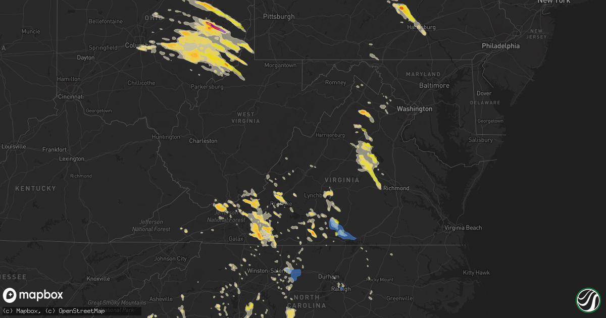
Hail Map in Virginia on June 16, 2022
Get this storm
June 16 map
$229
one time, instant access
Download today. No call, no setup
Keep the $229
Bought the map and want the full workflow? Apply the entire $229 to a subscription within 7 days. None of it is wasted.
Every map, not just this one
This buys you this map. Subscription and you get every map we run, in the markets you choose from a few cities to whole states to nationwide. Plus real-time alerts the moment a storm fires.
Contact data
Name, contact info, occupancy, even credit band for addresses in the footprint. You go from where it hit to who to call.
Become the source they trust
Unlimited branding weather history reports on demand. You already have the documented answer ready for the property owner, and you are the one who showed up with it.
Property data and RoofTrace estimates
Pull up any address you have got, its value and the exact code rules for that jurisdiction, straight from One Click Code. Then RoofTrace estimates the squares, pitch, and roof value, priced the way you price.
Storm reports in Virginia
Virginia
| Date | Description |
|---|---|
| 06/16/20226:55 PM CDT | 2 trees downed onto a structure. |
| 06/16/20226:47 PM CDT | Preliminary survey shows widespread uprooted and snapped trees on rock castle and old stage roads. 16 homes were damaged. Widespread power outages. Estimated width was |
| 06/16/20226:02 PM CDT | Baseball stands and fencing significantly damaged. |
| 06/16/20225:55 PM CDT | Trees down mt airy rd. |
| 06/16/20225:45 PM CDT | A local report indicates 1.00 inch wind near 6 SE ORANGE |
| 06/16/20225:35 PM CDT | Elizabeth trice walton park. |
| 06/16/20225:35 PM CDT | Trees down kennen rd. |
| 06/16/20225:25 PM CDT | A local report indicates 1.25 inch wind near ORANGE |
| 06/16/20225:25 PM CDT | Multiple reports of trees down in the city of orange. |
| 06/16/20225:12 PM CDT | Tree down in the 2000 block of celt rd. |
| 06/16/20225:11 PM CDT | Tree down at the intersection of tatums school rd. And locust grove church rd. |
| 06/16/20225:11 PM CDT | Tree down in the 900 block of locust grove church rd. |
| 06/16/20225:11 PM CDT | Tree down along wrights ln. |
| 06/16/20225:10 PM CDT | Trees down ellisville dr. |
| 06/16/20225:06 PM CDT | Tree blew down on plank road near constitution highway. |
| 06/16/20224:54 PM CDT | Numerous trees blew down along the corridor of james madison hwy... Zachary taylor hwy and rapidan rd. |
| 06/16/20224:43 PM CDT | A tree blew down near the 11200 block of st paul's rd. |
| 06/16/20224:38 PM CDT | A tree blew down onto power lines near opal rd and south pines rd. |
| 06/16/20224:19 PM CDT | A local report indicates 1.00 inch wind near 2 NNE REVA |
| 06/16/20224:18 PM CDT | A local report indicates 1.00 inch wind near 2 E SLATE MILLS |
| 06/16/20223:53 PM CDT | Tree down on moody creek rd. |
| 06/16/20223:49 PM CDT | Tree down on barnesville highway. |
| 06/16/20223:47 PM CDT | Tree down on jackson vaughn rd. |
| 06/16/20223:47 PM CDT | Tree down on jackson vaughn rd. Richmond nc 3501 7975 numerous trees and power lines down throughout richmond county. |
| 06/16/20223:43 PM CDT | Tree down on colemans ferry rd. |
| 06/16/20223:43 PM CDT | Tree down on va 92... Kings highway. |
| 06/16/20223:41 PM CDT | Tree down on george washington highway. |
| 06/16/20223:40 PM CDT | Numerous trees down across the county. |
| 06/16/20223:38 PM CDT | Tree down on edgewood lane. |
| 06/16/20223:31 PM CDT | A tree blew down near frogtown rd and providence ln. |
| 06/16/20223:31 PM CDT | A tree blew down near frogtown rd and providence ln. |
| 06/16/20223:28 PM CDT | Multiple large tree branches down off of fairhunt drive. |
| 06/16/20223:28 PM CDT | Multiple branches down and a tree uprooted on corro place. |
| 06/16/20223:27 PM CDT | Several large branches down on sycolin road near the sycolin creek. |
| 06/16/20223:25 PM CDT | A tree blew down near blue ridge mountain rd and john mosby hwy. |
| 06/16/20223:20 PM CDT | Tree uprooted on bellevue rd. |
| 06/16/20223:20 PM CDT | Trees blew down in loudon county on northbound va-651 gap road near us-15 james monroe highway. |
| 06/16/20223:02 PM CDT | Tree down. Time estimated from radar. |
| 06/16/20223:02 PM CDT | Tree down. Time estimated from radar. |
| 06/16/20222:54 PM CDT | A local report indicates 1.75 inch wind near CHESTER GAP |
| 06/16/20222:52 PM CDT | A local report indicates 1.50 inch wind near 2 SE CHESTER GAP |
| 06/16/20222:50 PM CDT | Tree down near hummingbird lane. |
| 06/16/20222:38 PM CDT | Tree down on rocksprings road. |
| 06/16/20222:38 PM CDT | Tree on powerline in the 2900 block of south boston hwy. |
| 06/16/20222:36 PM CDT | Tree down. Time estimated from radar. |
| 06/16/20222:32 PM CDT | Tree on power line. Time estimated from radar. |
| 06/16/20222:30 PM CDT | Tree down on lime plant road. |
| 06/16/20222:28 PM CDT | Tree and power line down. Time estimated from radar. |
| 06/16/20222:28 PM CDT | Tree on power line. |
| 06/16/20222:26 PM CDT | Tree and power lines down. Time estimated from radar. |
| 06/16/20222:25 PM CDT | Tree on house. Time estimated from radar. |
| 06/16/20222:24 PM CDT | From picture relayed by wdbj7. Time estimated from radar. |
| 06/16/20222:24 PM CDT | Corrects previous hail report from 1 ene keeling. From picture relayed by wdbj7. Time estimated from radar. |
| 06/16/20222:22 PM CDT | Trees and power lines down in the 3300 block of old richmond rd. |
| 06/16/20222:20 PM CDT | Tree on vehicle. Time estimated from radar. |
| 06/16/20222:20 PM CDT | Tree on vehicle. Time estimated from radar. |
| 06/16/20222:15 PM CDT | Hail to the size of quarters for up to 15 minutes. |
| 06/16/20222:10 PM CDT | Tree down on mount view rd near blairs va. |
| 06/16/20222:04 PM CDT | Tree on powerline on hickory forest rd. |
| 06/16/20221:20 PM CDT | A business on coleman lane reported at least one large tree blown down by thunderstorm winds and several large branches down. |
| 06/16/20221:20 PM CDT | Thunderstorm winds blew down a tree near the intersection of carver road and creekside drive. |
| 06/16/20221:16 PM CDT | Tree down in the 100 block of naff road. Time estimated from radar. |
| 06/16/20221:13 PM CDT | Tree down in the road... Blocking one lane on appalachian drive. Also tree on powerline. Before fieldale bridge... Near intersection of brandon rd and daniels creek rd. |
| 06/16/20221:00 PM CDT | Thunderstorm winds blew a tree down on pioneer trail. |
| 06/16/202212:47 PM CDT | Tree down blocking one lane of road. Near intersection of fair oaks drive and henry street in stanleytown va. |
| 06/16/20226:36 AM CDT | At 1136 PM EDT, a severe thunderstorm was located near Oriskany, moving southeast at 25 mph. HAZARD...60 mph wind gusts. SOURCE...Radar indicated. IMPACT...Expect damage to roofs, siding, and trees. Locations impacted include... Alleghany... Covington... Clifton Forge... Buchanan... Glasgow... Troutville... and New Castle. |
| 06/16/20226:30 AM CDT | At 1129 PM EDT, a severe thunderstorm was located over South Boston, moving southeast at 15 mph. Another strong storm was located near Alton. HAZARD...60 mph wind gusts and quarter size hail. SOURCE...Radar indicated. IMPACT...Hail damage to vehicles is expected. Expect wind damage to roofs, siding, and trees. Locations impacted include... South Boston... Halifax... Scottsburg... Hitesburg... Cluster Springs... Staunton River State Park... and Dryburg. |
| 06/16/20226:24 AM CDT | At 1124 PM EDT, a severe thunderstorm was located near Rainelle, moving southeast at 35 mph. HAZARD...60 mph wind gusts. SOURCE...Radar indicated. IMPACT...Expect damage to roofs, siding, and trees. Locations impacted include... Lewisburg... Hinton... White Sulphur Springs... Ronceverte... Rainelle... Alderson... and Rupert.This includes The following Location The West Virginia StateFairgrounds. |
| 06/16/20225:40 AM CDT | At 1040 PM EDT, severe thunderstorms were located along a line extending from near Greenbank to 6 miles southwest of Snowshoe to 7 miles east of Camden-On-gauley, moving south at 40 mph. HAZARD...Ping pong ball size hail and 60 mph wind gusts. SOURCE...Radar indicated. IMPACT...People and animals outdoors will be injured. Expect hail damage to roofs, siding, windows, and vehicles. Expect wind damage to roofs, siding, and trees. Locations impacted include... Marlinton, Cass Scenic Railroad, Greenbank, Webster Springs, Addison (Webster Springs), Snowshoe, Mingo, Cowen, Durbin, Hillsboro, Dunmore, Monterville, Arbovale, Bartow, Cranberry Mountain Nature Center, Slaty Fork, Minnehaha Springs, Upper Glade, Frost and Boyer. |
| 06/16/20225:13 AM CDT | At 1013 PM EDT, severe thunderstorms were located along a line extending from near Mill Creek to 8 miles southeast of Sutton, moving south at 45 mph. HAZARD...60 mph wind gusts and quarter size hail. SOURCE...Radar indicated. IMPACT...Hail damage to vehicles is expected. Expect wind damage to roofs, siding, and trees. Locations impacted include... Marlinton, Cass Scenic Railroad, Greenbank, Webster Springs, Addison (Webster Springs), Mill Creek, Snowshoe, Holly River State Park, Mingo, Cowen, Durbin, Hillsboro, Huttonsville, Arbovale, Cheat Bridge, Minnehaha Springs, Upper Glade, Helvetia, Pickens and Waneta. |
| 06/16/20224:22 AM CDT | At 922 PM EDT, a severe thunderstorm was located near Pilot, moving southeast at 30 mph. HAZARD...60 mph wind gusts. SOURCE...Radar indicated. IMPACT...Expect damage to roofs, siding, and trees. Locations impacted include... Christiansburg... Rocky Mount... Floyd... Pilot... Ferrum... Terrys Fork... and Endicott. |
| 06/16/20223:14 AM CDT | At 812 PM EDT, a severe thunderstorm was located near Sabot, or 7 miles northeast of Powhatan, moving southeast at 45 mph. HAZARD...60 mph wind gusts and half dollar size hail. SOURCE...Radar indicated. IMPACT...Minor damage to vehicles is possible. Expect wind damage to trees and powerlines. This severe thunderstorm will be near... Moseley around 825 PM EDT.Other locations impacted by this severe thunderstorm include GoodwinsStore, Flat Rock, Crozier, Winterpock, Jefferson, Midlothian,Subletts, Skinquarter, Fine Creek Mills and Holly Hills. |
| 06/16/20222:42 AM CDT | At 742 PM EDT, a severe thunderstorm was located near Stanardsville, or 7 miles southwest of Madison, moving east at 20 mph. HAZARD...60 mph wind gusts and quarter size hail. SOURCE...Radar indicated. IMPACT...Damaging winds will cause some trees and large branches to fall. This could injure those outdoors, as well as damage homes and vehicles. Roadways may become blocked by downed trees. Localized power outages are possible. Unsecured light objects may become projectiles. Locations impacted include... Orange, Stanardsville, Gordonsville, Ruckersville, Quinque, Eheart, Lydia, Barboursville, Montpelier Station, Newtown, Nasons, Madison Mills, Montford, Old Somerset, Amicus, Somerset, Hood, Locust Dale, Mcmullen and Rapidan. |
| 06/16/20222:19 AM CDT | At 719 PM EDT, a severe thunderstorm was located over Montebello, or 14 miles north of Forks Of Buffalo, moving east at 25 mph. HAZARD...Quarter size hail. SOURCE...Radar indicated. IMPACT...Some hail damage to agriculture is expected. Locations impacted include... Shipman, Montebello, Lovingston, Bryant, Jonesboro, Elma, Tyro, Rockfish, Faber and Massies Mill. |
| 06/16/20222:11 AM CDT | At 711 PM EDT, a severe thunderstorm was located near Boswells Tavern, or 12 miles east of Charlottesville, moving southeast at 20 mph. HAZARD...Ping pong ball size hail and 60 mph wind gusts. SOURCE...Radar indicated. IMPACT...Damaging winds will cause some trees and large branches to fall. This could injure those outdoors, as well as damage homes and vehicles. Roadways may become blocked by downed trees. Localized power outages are possible. Unsecured light objects may become projectiles. Locations impacted include... Campbell, Cobham and Cismont. |
| 06/16/20221:40 AM CDT | At 640 PM EDT, a severe thunderstorm was located near Troy, or 8 miles north of Palmyra, moving southeast at 20 mph. HAZARD...60 mph wind gusts and half dollar size hail. SOURCE...Radar indicated. IMPACT...Minor damage to vehicles is possible. Expect wind damage to trees and powerlines. This severe thunderstorm will be near... Ferncliff around 655 PM EDT. Kents Store around 705 PM EDT. Hadensville around 725 PM EDT.Other locations impacted by this severe thunderstorm include Bybee,Zion Crossroads, Wilmington, Stage Junction, Caledonia and Tabscott. |
| 06/16/20221:37 AM CDT | At 634 PM EDT, a severe thunderstorm was located near Orange, moving southeast at 15 mph. THIS IS A DESTRUCTIVE STORM FOR Somerset, Orange and Montpellier Station. HAZARD...Baseball size hail and 70 mph wind gusts. SOURCE...Radar indicated. IMPACT...Expect wind damage to trees and power lines. Locations impacted include... Orange, Gordonsville, Thornhill, Madison Mills, Montford, Lahore, Old Somerset, Montpelier Station, Madison Run and Somerset. |
| 06/16/20221:28 AM CDT | At 628 PM EDT, a severe thunderstorm was located over Mineral, moving southeast at 20 mph. HAZARD...Ping pong ball size hail and 60 mph wind gusts. SOURCE...Radar indicated. IMPACT...People and animals outdoors will be injured. Expect hail damage to roofs, siding, windows, and vehicles. Expect wind damage to trees and powerlines. This severe thunderstorm will be near... Bumpass around 650 PM EDT.Other locations impacted by this severe thunderstorm includePendleton, Beaverdam, Louisa Airport, Fredericks Hall, WaresCrossroads, Hewlett, Locust Creek, Mabelton, Apple Grove and Cuckoo. |
| 06/16/20221:13 AM CDT | At 613 PM EDT, a severe thunderstorm was located near Orange, moving southeast at 15 mph. HAZARD...Ping pong ball size hail and 60 mph wind gusts. SOURCE...Radar indicated. IMPACT...Damaging winds will cause some trees and large branches to fall. This could injure those outdoors, as well as damage homes and vehicles. Roadways may become blocked by downed trees. Localized power outages are possible. Unsecured light objects may become projectiles. Locations impacted include... Orange, Gordonsville, Mine Run, Verdiersville, Montpelier Station, Thornhill, Nasons, Madison Mills, Montford, Glenora, Old Somerset, Unionville, Somerset, Locust Dale, Rhoadesville, Rapidan, Madison Run, Pratts, Rochelle and Aroda. |
| 06/16/202212:58 AM CDT | At 558 PM EDT, a severe thunderstorm was located near Hume, or 11 miles west of Warrenton, moving southeast at 15 mph. HAZARD...60 mph wind gusts and quarter size hail. SOURCE...Radar indicated. IMPACT...Damaging winds will cause some trees and large branches to fall. This could injure those outdoors, as well as damage homes and vehicles. Roadways may become blocked by downed trees. Localized power outages are possible. Unsecured light objects may become projectiles. Locations impacted include... Warrenton, Bealeton, New Baltimore, Opal, Flint Hill, Turnbull, Auburn, Hackleys Crossroads, Casanova, Jeffersonton, Cresthill and Orlean. |
| 06/16/202212:52 AM CDT | Tree down across pandapas pond rd. |
| 06/16/202212:48 AM CDT | One tree reported down due to thunderstorm winds along wilderness road. |
| 06/16/202212:48 AM CDT | One tree down due to thunderstorm winds along the 1400 block of walker creek valley road. |
| 06/16/202212:45 AM CDT | At 545 PM EDT, a severe thunderstorm was located near Louisa, moving east at 15 mph. HAZARD...60 mph wind gusts and quarter size hail. SOURCE...Radar indicated. IMPACT...Minor damage to vehicles is possible. Expect wind damage to trees and powerlines. This severe thunderstorm will be near... Mineral around 605 PM EDT. Bumpass around 630 PM EDT.Other locations impacted by this severe thunderstorm includePendleton, Louisa Airport, Fredericks Hall, Trevilians, WaresCrossroads, Vawter Corner and Cuckoo. |
| 06/16/202212:45 AM CDT | At 545 PM EDT, a severe thunderstorm was located near Orange, moving east at 15 mph. HAZARD...Golf ball size hail and 60 mph wind gusts. SOURCE...Radar indicated. IMPACT...Expect wind damage to trees and power lines. Hail is large enough to dent and damage vehicles. Some hail damage to roofs, siding, and windows is possible. Locations impacted include... Orange, Mine Run, Rhoadesville, Brokenburg, Parker, Everona, Verdiersville, Burr Hill, Madison Run, Locust Grove, Gold Dale, Thornhill, Nasons, Logan, Lahore, Glenora, Lake Of The Woods, Unionville and Cookstown. |
| 06/16/202212:28 AM CDT | At 528 PM EDT, a severe thunderstorm was located near Orange, moving east at 20 mph. HAZARD...60 mph wind gusts and quarter size hail. SOURCE...Radar indicated. IMPACT...Damaging winds will cause some trees and large branches to fall. This could injure those outdoors, as well as damage homes and vehicles. Roadways may become blocked by downed trees. Localized power outages are possible. Unsecured light objects may become projectiles. Locations impacted include... Culpeper, Orange, Brightwood, Raccoon Ford, Stevensburg, Rapidan, Oakpark, Pratts, Aroda, Winston, Madison Mills, Mitchells, Fordsville, Twymans Mill, Leon and Locust Dale. |
| 06/16/202212:24 AM CDT | At 524 PM EDT, a severe thunderstorm was located near Arcola, or near South Riding, moving southeast at 20 mph. HAZARD...60 mph wind gusts and quarter size hail. SOURCE...Radar indicated. IMPACT...Damaging winds will cause some trees and large branches to fall. This could injure those outdoors, as well as damage homes and vehicles. Roadways may become blocked by downed trees. Localized power outages are possible. Unsecured light objects may become projectiles. Locations impacted include... Centreville, South Riding, Burke, Linton Hall, Chantilly, Bull Run, Haymarket, Manassas, Sudley, Manassas Park, Fairfax Station, Gainesville, Nokesville, Clifton, Catharpin, Woolsey, Aldie, Halfway and Broad Run. |
| 06/16/202212:21 AM CDT | Several trees reported down along hwy 220 from boones mill to grassy hill. |
| 06/16/202212:15 AM CDT | A few trees down in stewartsville... Along route 24 and also goodview road. Ff at golf club of florissant. One large tree down... Blocking estates drive in florissant in b |
| 06/16/202212:15 AM CDT | A few trees down in stewartsville... Along route 24 and also goodview road. |
| 06/16/202212:12 AM CDT | At 512 PM EDT, a severe thunderstorm was located 7 miles southeast of Sperryville, or 10 miles northwest of Culpeper, moving southeast at 15 mph. HAZARD...Golf ball size hail and 70 mph wind gusts. SOURCE...Radar indicated. IMPACT...Expect wind damage to trees and power lines. Hail is large enough to dent and damage vehicles. Some hail damage to roofs, siding, and windows is possible. Locations impacted include... Culpeper, Castleton, Catalpa, Slate Mills, Brandy Station, Woodville, Winston, Cardova, Reva, Rixeyville, Alanthus, Boston and Five Forks. |
| 06/16/202212:11 AM CDT | Tree down. |
| 06/16/202212:00 AM CDT | One tree down on poor farm road. |
| 06/15/202211:59 PM CDT | Tree down. |
| 06/15/202211:57 PM CDT | At 456 PM EDT, a severe thunderstorm was located near Hume, or 11 miles west of Warrenton, moving southeast at 20 mph. HAZARD...60 mph wind gusts and quarter size hail. SOURCE...Radar indicated. IMPACT...Damaging winds will cause some trees and large branches to fall. This could injure those outdoors, as well as damage homes and vehicles. Roadways may become blocked by downed trees. Localized power outages are possible. Unsecured light objects may become projectiles. Locations impacted include... Warrenton, Bealeton, Hume, New Baltimore, Opal, Turnbull, Airlie, Auburn, Hackleys Crossroads, Jeffersonton, Cresthill and Orlean. |
| 06/15/202211:57 PM CDT | Tree down at shadwell drive and waterfall drive. |
| 06/15/202211:30 PM CDT | At 430 PM EDT, a severe thunderstorm was located near Luray, or 18 miles north of Madison, moving east at 20 mph. HAZARD...60 mph wind gusts and quarter size hail. SOURCE...Radar indicated. IMPACT...Damaging winds will cause some trees and large branches to fall. This could injure those outdoors, as well as damage homes and vehicles. Roadways may become blocked by downed trees. Localized power outages are possible. Unsecured light objects may become projectiles. Locations impacted include... Luray, Sperryville, Kimball, Castleton, Ida, Viewtown, Nethers, Woodville, Amissville, Fairview, Five Forks, Panorama, Rock Mills, Cardova, Skyland and Boston. |
| 06/15/202211:23 PM CDT | Tree down. |
| 06/15/202211:22 PM CDT | At 422 PM EDT, a severe thunderstorm was located near Front Royal, moving east at 20 mph. HAZARD...60 mph wind gusts and quarter size hail. SOURCE...Radar indicated. IMPACT...Damaging winds will cause some trees and large branches to fall. This could injure those outdoors, as well as damage homes and vehicles. Roadways may become blocked by downed trees. Localized power outages are possible. Unsecured light objects may become projectiles. Locations impacted include... Front Royal, Hume, Delaplane, Linden, Marshall, Chester Gap, Huntly, Arco, Rectortown, Glen Echo, Meadowville, Markham, Browntown, Ashville, Ada and Riverside. |
| 06/15/202211:12 PM CDT | At 412 PM EDT, a severe thunderstorm was located 7 miles north of Linden, or 9 miles northeast of Front Royal, moving east at 20 mph. HAZARD...60 mph wind gusts and quarter size hail. SOURCE...Radar indicated. IMPACT...Damaging winds will cause some trees and large branches to fall. This could injure those outdoors, as well as damage homes and vehicles. Roadways may become blocked by downed trees. Localized power outages are possible. Unsecured light objects may become projectiles. Locations impacted include... Saint Louis, Blue Mountain, Howellsville, Millwood, White Post, Upperville, Bethel and Paris. |
| 06/15/202211:07 PM CDT | At 407 PM EDT, a severe thunderstorm was located near Mike, or near Red House, moving southeast at 30 mph. HAZARD...60 mph wind gusts and quarter size hail. SOURCE...Radar indicated. IMPACT...Hail damage to vehicles is expected. Expect wind damage to roofs, siding, and trees. Locations impacted include... Appomattox... Keysville... Charlotte Court House... Phenix... Red House... Concord... and Drakes Branch. |
| 06/15/202211:04 PM CDT | One tree reported down due to thunderstorm winds along purgatory mountain road. |
| 06/15/202210:58 PM CDT | At 357 PM EDT, a severe thunderstorm was located over Hodges, or near Altavista, moving southeast at 30 mph. HAZARD...60 mph wind gusts and quarter size hail. SOURCE...Radar indicated. IMPACT...Hail damage to vehicles is expected. Expect wind damage to roofs, siding, and trees. Locations impacted include... South Boston... Altavista... Halifax... Hurt... Brookneal... Charlotte Court House... and Phenix. |
| 06/15/202210:52 PM CDT | Power lines down. |
| 06/15/202210:51 PM CDT | Tree down. |
| 06/15/202210:50 PM CDT | A tree down as well as power lines. |
| 06/15/202210:43 PM CDT | At 343 PM EDT, a severe thunderstorm was located near Front Royal, moving east at 20 mph. HAZARD...60 mph wind gusts and quarter size hail. SOURCE...Radar indicated. IMPACT...Damaging winds will cause some trees and large branches to fall. This could injure those outdoors, as well as damage homes and vehicles. Roadways may become blocked by downed trees. Localized power outages are possible. Unsecured light objects may become projectiles. Locations impacted include... Front Royal, Hume, Delaplane, Linden, Marshall, Chester Gap, Huntly, Arco, Rectortown, Karo, Glen Echo, Meadowville, Markham, Browntown, Ashville, Ada and Riverside. |
| 06/15/202210:30 PM CDT | At 329 PM EDT, a severe thunderstorm was located over Stonewall, or near Concord, moving east at 20 mph. HAZARD...60 mph wind gusts and quarter size hail. SOURCE...Radar indicated. IMPACT...Hail damage to vehicles is expected. Expect wind damage to roofs, siding, and trees. Locations impacted include... Appomattox... Concord... Pamplin City... Appomattox National Historic Park... Riverville... Stonewall... and Hixburg. |
| 06/15/202210:22 PM CDT | Large tree down. |
| 06/15/202210:09 PM CDT | At 308 PM EDT, a severe thunderstorm was located near Bent Creek, moving south at 20 mph. HAZARD...60 mph wind gusts and quarter size hail. SOURCE...Radar indicated. IMPACT...Hail damage to vehicles is expected. Expect wind damage to roofs, siding, and trees. Locations impacted include... Appomattox... Bent Creek... Appomattox National Historic Park... Riverville... New Glasgow... Oakville... and Tower Hill. |
| 06/15/202210:05 PM CDT | At 305 PM EDT, a severe thunderstorm was located over Hurt, moving southeast at 10 mph. HAZARD...60 mph wind gusts and quarter size hail. SOURCE...Radar indicated. IMPACT...Hail damage to vehicles is expected. Expect wind damage to roofs, siding, and trees. Locations impacted include... Altavista... Hurt... Gretna... Ingram... Mt Airy... Leesville... and Java. |
| 06/15/20229:52 PM CDT | At 252 PM EDT, a severe thunderstorm was located over Ayersville, or near Mayodan, moving southeast at 35 mph. HAZARD...60 mph wind gusts and quarter size hail. SOURCE...Radar indicated. IMPACT...Hail damage to vehicles is expected. Expect wind damage to roofs, siding, and trees. Locations impacted include... Eden... Reidsville... Wentworth... Mayodan... Madison... Stoneville... and Camp Springs. |
| 06/15/20229:27 PM CDT | At 227 PM EDT, a severe thunderstorm was located near Boones Mill, moving southeast at 10 mph. HAZARD...60 mph wind gusts and quarter size hail. SOURCE...Radar indicated. IMPACT...Hail damage to vehicles is expected. Expect wind damage to roofs, siding, and trees. Locations impacted include... Rocky Mount... Boones Mill... Penhook... Sydnorsville... Ferrum... Burnt Chimney... and Western Smith Mountain Lake. |
| 06/15/20229:16 PM CDT | At 215 PM EDT, a severe thunderstorm was located over Westfield, or near Pilot Mountain, moving southeast at 25 mph. HAZARD...60 mph wind gusts and quarter size hail. SOURCE...Radar indicated. IMPACT...Hail damage to vehicles is expected. Expect wind damage to roofs, siding, and trees. Locations impacted include... Mount Airy... Fairview... Flat Rock... Yadkinville... Dobson... Pilot Mountain... and Walnut Cove. |
| 06/15/20229:02 PM CDT | At 201 PM EDT, a severe thunderstorm was located over Penns Store, or near Spencer, moving southeast at 10 mph. HAZARD...60 mph wind gusts and half dollar size hail. SOURCE...Radar indicated. IMPACT...Hail damage to vehicles is expected. Expect wind damage to roofs, siding, and trees. Locations impacted include... Mayodan... Madison... Stoneville... Sandy Ridge... Spencer... Penns Store... and Price. |
| 06/15/20228:52 PM CDT | One tree down due to thunderstorm winds along union valley road. |
| 06/15/20228:52 PM CDT | Tree down on owens rd. |
| 06/15/20228:48 PM CDT | Multiple trees reported down due to thunderstorm winds along route 8 from riner to floyd. |
| 06/15/20228:48 PM CDT | Tree down on state park rd near claytor lake. |
| 06/15/20228:48 PM CDT | Several trees down along childress rd. |
| 06/15/20228:46 PM CDT | One tree down due to thunderstorm winds along fairview church road. |
| 06/15/20228:46 PM CDT | One tree down due to thunderstorm winds along fairview church road. |
| 06/15/20228:38 PM CDT | Tree down in dublin on rt 100. |
| 06/15/20227:25 PM CDT | Power outages. |
| 06/15/20227:15 PM CDT | Numerous trees down. |
| 06/15/20227:10 PM CDT | Numerous trees down. |
All States Impacted by Hail Map on June 16, 2022
Cities Impacted by Hail Map on June 16, 2022
- Fort Covington, NY
- Brushton, NY
- Oswego, NY
- Hannibal, NY
- Fine, NY
- Fulton, NY
- Clay, NY
- Brewerton, NY
- Trenton, MO
- Spickard, MO
- North Bend, PA
- Lock Haven, PA
- Chaumont, NY
- Bellwood, NE
- David City, NE
- Bethany, MO
- Ridgeway, MO
- Martinsville, MO
- Ransomville, NY
- Wilson, NY
- Canandaigua, NY
- Stanley, NY
- Bloomfield, IA
- Moulton, IA
- Verdon, NE
- Salem, NE
- Humboldt, NE
- Falls City, NE
- Dawson, NE
- Lacona, NY
- Sandy Creek, NY
- Pulaski, NY
- Chaffee, NY
- West Valley, NY
- East Concord, NY
- Bliss, NY
- Sardinia, NY
- Springville, NY
- Arcade, NY
- Delevan, NY
- Yorkshire, NY
- Saegertown, PA
- Cambridge Springs, PA
- Hastings, IA
- Johnstown, OH
- Massena, NY
- Gouverneur, NY
- Theresa, NY
- Antwerp, NY
- Fort Drum, NY
- Philadelphia, NY
- Watertown, NY
- Rodman, NY
- La Fargeville, NY
- Abie, NE
- Bruno, NE
- Linwood, NE
- Honeoye Falls, NY
- Victor, NY
- Frederick, IL
- Mount Sterling, IL
- Rushville, IL
- Browning, IL
- Timewell, IL
- Elkhart, IL
- Garden Grove, IA
- Allerton, IA
- Princeton, MO
- Waterford, PA
- Edinboro, PA
- Wattsburg, PA
- Conneaut, OH
- McKean, PA
- Albion, PA
- Girard, PA
- Cranesville, PA
- Union City, PA
- Kingsville, OH
- Erie, PA
- Springboro, PA
- Shortsville, NY
- Palmyra, NY
- Farmington, NY
- Wolbach, NE
- Corning, IA
- Hermon, NY
- Eagleville, MO
- Hatfield, MO
- Cape Vincent, NY
- Clayton, NY
- Pennellville, NY
- Memphis, NY
- Clyde, NY
- Central Square, NY
- Cato, NY
- Jordan, NY
- Red Creek, NY
- Martville, NY
- Savannah, NY
- Wolcott, NY
- Sterling, NY
- Phoenix, NY
- Weedsport, NY
- Port Byron, NY
- Lyons, NY
- Sodus, NY
- North Rose, NY
- Baldwinsville, NY
- Brewster, OH
- Navarre, OH
- Geneseo, NY
- Clifton Springs, NY
- Leicester, NY
- Manchester, NY
- Phelps, NY
- Conesus, NY
- Bloomfield, NY
- Honeoye, NY
- Silver Springs, NY
- Gainesville, NY
- Silver Lake, NY
- Mount Morris, NY
- Perry, NY
- Hemlock, NY
- Castile, NY
- Lima, NY
- Livonia, NY
- Hammond, NY
- De Peyster, NY
- Cattaraugus, NY
- East Otto, NY
- Snow Shoe, PA
- Moshannon, PA
- Drakesville, IA
- Syracuse, NY
- Liverpool, NY
- Conneautville, PA
- Greenville, PA
- Kinsman, OH
- Fowler, OH
- Burghill, OH
- Farmdale, OH
- Howard, OH
- Gambier, OH
- Gilman City, MO
- Kellerton, IA
- Lamoni, IA
- Landisburg, PA
- Sherman, NY
- Findley Lake, NY
- Clymer, NY
- Newark, NY
- Jamesville, NY
- Auburn, NY
- Copenhagen, NY
- Clarence, PA
- Pottersdale, PA
- James City, PA
- Weedville, PA
- Clarendon, PA
- Kersey, PA
- Bellefonte, PA
- Benezett, PA
- Tidioute, PA
- Centerville, PA
- Spartansburg, PA
- Driftwood, PA
- Grand Valley, PA
- Titusville, PA
- Sheffield, PA
- Saint Marys, PA
- Howard, PA
- Pittsfield, PA
- Ridgway, PA
- Johnsonburg, PA
- Sinnamahoning, PA
- Marienville, PA
- Kane, PA
- Tionesta, PA
- Karthaus, PA
- Kersey, CO
- Greeley, CO
- La Salle, CO
- Geneva, NY
- Fremont, IN
- Angola, IN
- Edon, OH
- Warren, OH
- Vienna, OH
- Emlenton, PA
- Masury, OH
- Jackson Center, PA
- Transfer, PA
- Petrolia, PA
- Stoneboro, PA
- Parker, PA
- Mercer, PA
- Eau Claire, PA
- Harrisville, PA
- Rimersburg, PA
- Hermitage, PA
- Fredonia, PA
- Fairmount City, PA
- Clintonville, PA
- Cortland, OH
- Hilliards, PA
- Clark, PA
- West Sunbury, PA
- Karns City, PA
- New Bethlehem, PA
- Boyers, PA
- Grove City, PA
- Sligo, PA
- Sharpsville, PA
- Polk, PA
- Bruin, PA
- Kennerdell, PA
- North Bloomfield, OH
- Chardon, OH
- Huntsburg, OH
- Middlefield, OH
- Novelty, OH
- Chesterland, OH
- Orwell, OH
- Newbury, OH
- Burton, OH
- Windsor, OH
- Gates Mills, OH
- Russell, NY
- Medina, NY
- Middleport, NY
- Richville, NY
- De Kalb Junction, NY
- Redwood, NY
- Grand River, IA
- Albany, MO
- New Hampton, MO
- McFall, MO
- Tingley, IA
- Ellston, IA
- Browning, MO
- Laredo, MO
- Chula, MO
- Humphreys, MO
- Franklin, PA
- Cooperstown, PA
- Eagle Rock, VA
- Clifton Forge, VA
- Mulberry Grove, IL
- Bingham, IL
- Ramsey, IL
- Fillmore, IL
- Coffeen, IL
- Galt, MO
- Renovo, PA
- Statesville, NC
- Glenwood, IA
- Malvern, IA
- Pacific Junction, IA
- Tecumseh, NE
- Rockport, IL
- Pittsfield, IL
- Pleasant Hill, IL
- Benton, IA
- Clearfield, IA
- Bedford, IA
- Blockton, IA
- Rutherfordton, NC
- Chesnee, SC
- Clarence, MO
- Lentner, MO
- Powersville, MO
- Seymour, IA
- Lucerne, MO
- Newtown, MO
- Lineville, IA
- Pollock, MO
- Harris, MO
- Mercer, MO
- Unionville, MO
- Milan, MO
- Corydon, IA
- Clinton, NC
- Richwoods, MO
- Lonedell, MO
- Sullivan, MO
- Hoxie, KS
- Bland, VA
- Alpharetta, GA
- Morrisonville, IL
- Nokomis, IL
- Clover, SC
- Belmont, NC
- Gastonia, NC
- Darlington, SC
- Long Island, VA
- Greencastle, PA
- Clear Spring, MD
- Hagerstown, MD
- Mercersburg, PA
- Pisgah Forest, NC
- High Point, NC
- Jamestown, NC
- Ashland, IL
- Liberty, IL
- Mendenhall, MS
- Salem, WV
- Vesuvius, VA
- Lincolnton, NC
- Maybeury, WV
- Pocahontas, VA
- Bluefield, VA
- Welch, WV
- Bramwell, WV
- Luray, MO
- Queen City, MO
- Gibbs, MO
- Kirksville, MO
- Shelbyville, MO
- Brashear, MO
- Milton, IA
- La Plata, MO
- Cantril, IA
- Baring, MO
- Memphis, MO
- Atlanta, MO
- Hurdland, MO
- Bethel, MO
- Knox City, MO
- Rutledge, MO
- Novinger, MO
- Greentop, MO
- Farmington, IA
- Keosauqua, IA
- Mount Sterling, IA
- Bonaparte, IA
- Novelty, MO
- Kahoka, MO
- Pulaski, IA
- Downing, MO
- Edina, MO
- Arbela, MO
- La Belle, MO
- Lancaster, MO
- Newark, MO
- Green Castle, MO
- Leonard, MO
- Roanoke, VA
- Salem, VA
- Mifflin, PA
- McAlisterville, PA
- McClure, PA
- Millerstown, PA
- Mifflintown, PA
- Shermans Dale, PA
- Port Royal, PA
- Newport, PA
- Oakland Mills, PA
- New Bloomfield, PA
- Duncannon, PA
- Lewistown, PA
- Thompsontown, PA
- Marianna, FL
- Grand Ridge, FL
- Oconee, IL
- Pana, IL
- Six Mile, SC
- Central, SC
- Aldie, VA
- Leesburg, VA
- Gretna, VA
- Chatham, VA
- Java, VA
- West Union, WV
- Bluford, IL
- Dix, IL
- Irvington, IL
- Centralia, IL
- Johnsonville, IL
- Keenes, IL
- Walnut Hill, IL
- Texico, IL
- Kell, IL
- Mount Vernon, IL
- Iuka, IL
- Pelham, NC
- Ruffin, NC
- Reidsville, NC
- Tarkio, MO
- Watson, MO
- Rock Port, MO
- Westboro, MO
- Winston, GA
- Whitesburg, GA
- Clio, SC
- Blenheim, SC
- Bennettsville, SC
- Bentonia, MS
- Benton, MS
- Rapidan, VA
- Reva, VA
- Boston, VA
- Culpeper, VA
- Mitchells, VA
- West, MS
- Sallis, MS
- Elba, AL
- Kinston, AL
- Samson, AL
- Quincy, FL
- Montpelier, VA
- Rockville, VA
- Northport, AL
- Purcellville, VA
- Scarbro, WV
- Mount Hope, WV
- Fayetteville, WV
- Kincaid, WV
- Maidens, VA
- Powhatan, VA
- Palmyra, VA
- Goochland, VA
- Crozier, VA
- Pratts, VA
- Louisa, VA
- Madison, VA
- Columbia, VA
- Barboursville, VA
- Sandy Hook, VA
- Keswick, VA
- Somerset, VA
- Rochelle, VA
- Aroda, VA
- Unionville, VA
- Troy, VA
- Gum Spring, VA
- Radiant, VA
- Ruckersville, VA
- Gordonsville, VA
- Mineral, VA
- Kents Store, VA
- Stanardsville, VA
- State Farm, VA
- Orange, VA
- Bumpass, VA
- Tiger, GA
- Lakemont, GA
- Hardy, VA
- Bessemer City, NC
- Fort Lupton, CO
- Hudson, CO
- Sylacauga, AL
- Talladega, AL
- Goodwater, AL
- Stockport, OH
- Waterford, OH
- Newport, VA
- Union Mills, NC
- Lake Lure, NC
- Tryon, NC
- Mill Spring, NC
- Thomasville, NC
- Winston Salem, NC
- Northfork, WV
- Kimball, WV
- Brookneal, VA
- Nathalie, VA
- Gladys, VA
- Ellerbe, NC
- Emerson, IA
- Red Oak, IA
- Old Fort, NC
- Marion, NC
- Macon, NC
- Warrenton, NC
- Campobello, SC
- Greer, SC
- Landrum, SC
- McBee, SC
- Bethune, SC
- Jefferson, SC
- Dwight, NE
- Browns Summit, NC
- Nashville, NC
- Chattahoochee, FL
- Bainbridge, GA
- Sneads, FL
- Coatsburg, IL
- Camp Point, IL
- Paloma, IL
- Quincy, IL
- Clayton, IL
- Fowler, IL
- Quinton, AL
- Dora, AL
- Cordova, AL
- Marion, SC
- Norwood, LA
- Kershaw, SC
- Covington, VA
- Marble Hill, MO
- Vinton, LA
- Greensboro, NC
- Summerfield, NC
- McLeansville, NC
- Eastover, SC
- Dalzell, SC
- Rembert, SC
- Weeping Water, NE
- Carlisle, SC
- Whitmire, SC
- Newberry, SC
- Union, SC
- Tuskegee, AL
- Camillus, NY
- Warners, NY
- Joanna, SC
- Kinards, SC
- Silverstreet, SC
- Hopkins, SC
- Randolph, AL
- Jemison, AL
- Brierfield, AL
- Norfolk, NY
- Chase Mills, NY
- Friend, NE
- Cordova, NE
- York, NE
- Waco, NE
- McCool Junction, NE
- Exeter, NE
- Beaver Crossing, NE
- Glenmont, OH
- Danville, OH
- Lewistown, MO
- Chesterhill, OH
- Marine, IL
- Alhambra, IL
- Rushville, OH
- Somerset, OH
- Thornville, OH
- Penokee, KS
- Hill City, KS
- Morland, KS
- Baylis, IL
- Versailles, IL
- Griggsville, IL
- Chambersburg, IL
- Orrick, MO
- Lamar, CO
- Gainesville, VA
- Haymarket, VA
- Jonesville, NC
- Hamptonville, NC
- Lerona, WV
- Peterstown, WV
- Pipestem, WV
- Halifax, VA
- Crystal Hill, VA
- Wilson, NC
- Lucama, NC
- McConnells, SC
- Chester, SC
- Trinity, NC
- New Castle, VA
- Elizabethtown, NC
- Garland, NC
- Pinewood, SC
- Summerton, SC
- Bishopville, SC
- Camden, SC
- Cassatt, SC
- Saluda, SC
- Ward, SC
- Picayune, MS
- Troy, AL
- Louisville, AL
- Clayton, AL
- Perkinston, MS
- Smithdale, MS
- Liberty, MS
- Orangeburg, SC
- Cordova, SC
- Warsaw, IL
- Basco, IL
- Golden, IL
- West Point, IL
- Bowen, IL
- Lewisberry, PA
- Etters, PA
- New Cumberland, PA
- Bremen, OH
- Ronceverte, WV
- Sinks Grove, WV
- Alderson, WV
- Estes Park, CO
- Heath, OH
- Granville, OH
- Newark, OH
- Camp Hill, PA
- Summerdale, PA
- Enola, PA
- Marysville, PA
- Mechanicsburg, PA
- Elliottsburg, PA
- Harrisburg, PA
- York Haven, PA
- Lemoyne, PA
- Nashport, OH
- Butler, OH
- Wheeler, IL
- Loveland, CO
- Berthoud, CO
- Webster Springs, WV
- Eskdale, WV
- Gallagher, WV
- Montgomery, WV
- Martinsburg, WV
- Hedgesville, WV
- Hamilton, VA
- Clay City, IL
- Flora, IL
- Hillsboro, IL
- Donnellson, IL
- Philadelphia, MO
- Monroe City, MO
- Crawley, WV
- Smoot, WV
- Rainelle, WV
- Highland, IL
- Pocahontas, IL
- Greenville, IL
- Carlyle, IL
- Breese, IL
- White Sulphur Springs, WV
- Ballard, WV
- Union, WV
- Greenville, WV
- Ripplemead, VA
- Lindside, WV
- Pembroke, VA
- Narrows, VA
- Martinsville, VA
- Patrick Springs, VA
- Bassett, VA
- Fieldale, VA
- Clinton, SC
- Laurens, SC
- Morganton, NC
- Mayesville, SC
- Gable, SC
- Hamer, SC
- Gibson, NC
- Hamlet, NC
- Laurinburg, NC
- Little Rock, SC
- Maxton, NC
- Rowland, NC
- Laurel Hill, NC
- Rockingham, NC
- McColl, SC
- Dillon, SC
- Monroe, NC
- Liberty Hill, SC
- Ridgeway, SC
- Heath Springs, SC
- Blackstock, SC
- Great Falls, SC
- Winnsboro, SC
- Maysville, GA
- Lamar, SC
- Timmonsville, SC
- Lawrenceville, GA
- Suwanee, GA
- Saint Francisville, LA
- Carriere, MS
- Mulga, AL
- Brundidge, AL
- Banks, AL
- Oakdale, LA
- Glenmora, LA
- Quaker City, OH
- Salesville, OH
- Milroy, PA
- Cook, NE
- Fredericktown, OH
- Cleveland, SC
- Marietta, SC
- Pickens, SC
- Evans, CO
- Villisca, IA
- Elliott, IA
- Green City, MO
- Rosebud, MO
- Owensville, MO
- Windsor, IL
- Strasburg, IL
- Neoga, IL
- Raleigh, NC
- Alexander, IL
- Jacksonville, IL
- Lemont, PA
- Huntingdon, PA
- Julian, PA
- Spring Mills, PA
- Centre Hall, PA
- University Park, PA
- State College, PA
- Boalsburg, PA
- Milesburg, PA
- Port Matilda, PA
- Humeston, IA
- Weldon, IA
- Decatur, IA
- Van Wert, IA
- Leon, IA
- Millersport, OH
- Pleasantville, OH
- Thurston, OH
- Baltimore, OH
- Lenox, IA
- Sharpsburg, IA
- Gravity, IA
- Lawndale, NC
- Cherryville, NC
- Udell, IA
- Unionville, IA
- Moravia, IA
- Centerville, IA
- Anabel, MO
- Pinnacle, NC
- Highland, KS
- Reedsville, PA
- Pilot Mountain, NC
- South Boston, VA
- Tribune, KS
- Ararat, NC
- Beardstown, IL
- Harrisburg, NC
- Landis, NC
- Concord, NC
- Charlotte, NC
- Kannapolis, NC
- China Grove, NC
- Matthews, NC
- Pennsboro, WV
- Perryville, MO
- Winchester, VA
- Hull, IL
- Sunset, SC
- Candor, NC
- Jackson Springs, NC
- Robbins, NC
- Seagrove, NC
- Eagle Springs, NC
- Star, NC
- Biscoe, NC
- Lashmeet, WV
- Matoaka, WV
- Beeson, WV
- Rock, WV
- Berkeley Springs, WV
- Lancaster, SC
- Mode, IL
- Stewardson, IL
- Shelbyville, IL
- Girard, IL
- Waggoner, IL
- Farmersville, IL
- Lugoff, SC
- Blythewood, SC
- Columbia, SC
- Elgin, SC
- Danielsville, GA
- Carnesville, GA
- Royston, GA
- Commerce, GA
- Harmony, NC
- Union Grove, NC
- Heflin, AL
- Munford, AL
- Oxford, AL
- Delta, AL
- Anniston, AL
- Alcolu, SC
- Dorchester, NE
- Crete, NE
- Columbus, NC
- Table Rock, NE
- The Plains, VA
- Middleburg, VA
- Rocky Gap, VA
- Bluefield, WV
- Princeton, WV
- Kennesaw, GA
- Marietta, GA
- Jane Lew, WV
- Glenville, WV
- Crawford, WV
- Orlando, WV
- French Creek, WV
- Camden, WV
- Tallmansville, WV
- Buckhannon, WV
- Rock Cave, WV
- Helvetia, WV
- Walkersville, WV
- Adrian, WV
- Horner, WV
- Weston, WV
- New Milton, WV
- Burnsville, WV
- Copen, WV
- Sand Fork, WV
- Linn, WV
- Alum Bridge, WV
- Pickens, WV
- Wytheville, VA
- Ceres, VA
- Ferrum, VA
- Valparaiso, NE
- Brainard, NE
- Ashland, NE
- Cottondale, FL
- Campbellton, FL
- Chipley, FL
- Graceville, FL
- Alford, FL
- Bonifay, FL
- Sebree, KY
- Slaughters, KY
- Calhoun, KY
- New Douglas, IL
- Livingston, IL
- Staunton, IL
- North Tazewell, VA
- Falls Mills, VA
- Bastian, VA
- Alvo, NE
- Murdock, NE
- Greenwood, NE
- Hosford, FL
- Daleville, VA
- Vinton, VA
- Troutville, VA
- Catawba, VA
- Cloverdale, VA
- Travelers Rest, SC
- Benwood, WV
- Mcmechen, WV
- Cameron, WV
- Glen Dale, WV
- Wheeling, WV
- Jacobsburg, OH
- Moundsville, WV
- Bellaire, OH
- Glen Easton, WV
- Shadyside, OH
- Marshville, NC
- Wingate, NC
- Hartsville, SC
- Hurt, VA
- Altavista, VA
- Lynch Station, VA
- Friedheim, MO
- Oak Ridge, MO
- Daisy, MO
- Elon, NC
- Gibsonville, NC
- Newton, NC
- Lyman, SC
- Inman, SC
- Atlanta, GA
- Birmingham, AL
- Docena, AL
- Adamsville, AL
- Vale, NC
- Hickory, NC
- Bristol, FL
- Vernon Hill, VA
- Greenwood, FL
- Brevard, NC
- Belton, SC
- Williamston, SC
- Chancellor, AL
- Stokesdale, NC
- Belews Creek, NC
- Coffee Springs, AL
- Panacea, FL
- Cowpens, SC
- Spartanburg, SC
- Boiling Springs, SC
- Chesterville, OH
- Cardington, OH
- Mount Gilead, OH
- Catawba, SC
- Fort Mill, SC
- Rock Hill, SC
- Edgemoor, SC
- Roebuck, SC
- Pauline, SC
- Gainesville, GA
- Sumter, SC
- Cleveland, GA
- Dallas, GA
- Hiram, GA
- Austell, GA
- Douglasville, GA
- Smyrna, GA
- Temple, GA
- Mableton, GA
- Lithia Springs, GA
- Villa Rica, GA
- Bremen, GA
- Powder Springs, GA
- Blountstown, FL
- Altha, FL
- Mount Vernon, OH
- Utica, OH
- Blacklick, OH
- Pataskala, OH
- Reynoldsburg, OH
- Ponce De Leon, FL
- Middlebourne, WV
- Hacker Valley, WV
- Diana, WV
- Moberly, MO
- Jacksonville, MO
- Holliday, MO
- Centralia, MO
- Madison, MO
- Clark, MO
- Cairo, MO
- Thompson, MO
- Paris, MO
- Shelbina, MO
- Sorento, IL
- Worden, IL
- Huntly, VA
- Front Royal, VA
- Bentonville, VA
- Flint Hill, VA
- Amissville, VA
- Jeffersonton, VA
- Hume, VA
- Marshall, VA
- Chester Gap, VA
- Linden, VA
- Yadkinville, NC
- Boonville, NC
- Frohna, MO
- Santee, SC
- Elloree, SC
- Asheboro, NC
- Claremont, NC
- Stony Point, NC
- Taylorsville, NC
- Faison, NC
- Flowery Branch, GA
- Ruby, SC
- Mount Croghan, SC
- Cumming, GA
- Cloudcroft, NM
- Kellyton, AL
- Alexander City, AL
- Weogufka, AL
- Equality, AL
- Rockford, AL
- Roanoke, LA
- Marksville, LA
- Conover, NC
- Dexter, NY
- Brownville, NY
- Seneca Falls, NY
- Cayuga, NY
- Waterloo, NY
- Cammal, PA
- Oakley, KS
- Boyce, VA
- Brownstown, IL
- Noble, IL
- Abingdon, VA
- Pittsville, VA
- Sandy Level, VA
- Wilkesboro, NC
- Blair, SC
- Lynchburg, SC
- Rosman, NC
- Buford, GA
- Selma, AL
- Tallahassee, FL
- Sopchoppy, FL
- Carrabelle, FL
- Brock, NE
- Talmage, NE
- Belmont, OH
- Sardis, OH
- Cambridge, OH
- Gnadenhutten, OH
- Summerfield, OH
- Powhatan Point, OH
- Adamsville, OH
- New Concord, OH
- Norwich, OH
- Beallsville, OH
- Cadiz, OH
- Barnesville, OH
- Tippecanoe, OH
- Blue Rock, OH
- Conesville, OH
- White Cottage, OH
- Roseville, OH
- Freeport, OH
- Mount Perry, OH
- Hebron, OH
- Wingett Run, OH
- Fresno, OH
- Zanesville, OH
- Coshocton, OH
- Flushing, OH
- Chandlersville, OH
- Warsaw, OH
- Hopewell, OH
- Byesville, OH
- Duncan Falls, OH
- Crooksville, OH
- Kimbolton, OH
- Piedmont, OH
- Newcomerstown, OH
- West Lafayette, OH
- Jerusalem, OH
- Bethesda, OH
- Caldwell, OH
- New Matamoras, OH
- Woodsfield, OH
- Mcconnelsville, OH
- Lore City, OH
- Jacksontown, OH
- Frazeysburg, OH
- Dresden, OH
- Trinway, OH
- Sarahsville, OH
- Philo, OH
- Lewisville, OH
- Lower Salem, OH
- Belle Valley, OH
- Glenford, OH
- Graysville, OH
- Senecaville, OH
- Sistersville, WV
- Cumberland, OH
- Stone Creek, OH
- Dexter City, OH
- Uhrichsville, OH
- Alledonia, OH
- Pleasant City, OH
- Kipling, OH
- Port Washington, OH
- Hiwassee, VA
- Osceola, IA
- Platteville, CO
- Williamsfield, OH
- Andover, OH
- Hartstown, PA
- Jamestown, PA
- Cochranton, PA
- Adamsville, PA
- Atlantic, PA
- Hadley, PA
- Stanberry, MO
- Ravenwood, MO
- Worth, MO
- Gentry, MO
- Herrick, IL
- Chilhowie, VA
- Denver, NC
- Woodburn, IA
- Petersburg, IL
- Mystic, IA
- Melrose, IA
- Philipsburg, PA
- Herndon, WV
- Benton, IL
- Whittington, IL
- Penhook, VA
- Callands, VA
- Uniontown, MO
- Luray, VA
- Woodville, VA
- Sperryville, VA
- Etlan, VA
- Syria, VA
- Wallace, SC
- New Berlin, IL
- Waverly, IL
- Thayer, IL
- Loami, IL
- Auburn, IL
- Glenarm, IL
- Modesto, IL
- Virden, IL
- Chatham, IL
- Pawnee, IL
- Divernon, IL
- Macon, MO
- Crouse, NC
- Batesburg, SC
- Cayce, SC
- West Columbia, SC
- Gilbert, SC
- Leesville, SC
- Pelion, SC
- Lexington, SC
- Jackson, NC
- Alton, VA
- Saint Joseph, MO
- Gold Hill, NC
- Salisbury, NC
- Ingraham, IL
- Louisville, IL
- Farina, IL
- Mason, IL
- Newton, IL
- Edgewood, IL
- Xenia, IL
- Dieterich, IL
- Rinard, IL
- Sandstone, WV
- Hinton, WV
- Pence Springs, WV
- Gore, VA
- Madison, NC
- Poplarville, MS
- Havana, FL
- Blairs, VA
- Sutherlin, VA
- Keeling, VA
- Banco, VA
- Cainsville, MO
- Blythedale, MO
- Williamsburg, WV
- Asbury, WV
- Renick, WV
- Frankford, WV
- Maxwelton, WV
- Lewisburg, WV
- Albemarle, NC
- New London, NC
- Saxe, VA
- Randolph, VA
- Phenix, VA
- Scottsburg, VA
- Clover, VA
- Mocksville, NC
- Durant, MS
- Max Meadows, VA
- Flowood, MS
- Madison, MS
- Brandon, MS
- Ridgeland, MS
- Canton, MS
- Stuart, VA
- Meadows Of Dan, VA
- Woolwine, VA
- Floyd, VA
- Lyons, CO
- Elliston, VA
- Fairmont, NC
- Hayesville, NC
- Bedford, VA
- Thaxton, VA
- Montvale, VA
- Roseboro, NC
- Lebanon, VA
- Kings Mountain, NC
- Altamont, IL
- Effingham, IL
- Shumway, IL
- Beecher City, IL
- Watson, IL
- Teutopolis, IL
- Bessemer, AL
- Dallas, WV
- Triadelphia, WV
- Gerald, MO
- New Haven, MO
- Council, NC
- Kelly, NC
- Whiteville, NC
- Clarkton, NC
- Rocky Mount, VA
- Boones Mill, VA
- Callaway, VA
- Bladenboro, NC
- Land O'Lakes, FL
- Vidor, TX
- Johnston, SC
- Ridge Spring, SC
- Trenton, SC
- Aiken, SC
- Clio, AL
- Brookhaven, MS
- Fair Bluff, NC
- Mize, MS
- Mount Olive, MS
- Highland Home, AL
- Pickrell, NE
- Hallam, NE
- Cortland, NE
- Wilber, NE
- Adams, NE
- Firth, NE
- Clatonia, NE
- Letohatchee, AL
- Roaring River, NC
- Ronda, NC
- North Wilkesboro, NC
- Dobson, NC
- Elkin, NC
- Jennings, LA
- Climax, NC
- Franklinville, NC
- Randleman, NC
- Magnolia, MS
- Summit, MS
- Mayodan, NC
- Pearl River, LA
- Auburn, NE
- Johnson, NE
- Sophia, NC
- Enoree, SC
- Wedgefield, SC
- Liberty, SC
- Easley, SC
- Pendleton, SC
- Salley, SC
- Wagener, SC
- Wilson, LA
- Jackson, LA
- Ethel, LA
- Ashland, OH
- Wooster, OH
- Jeromesville, OH
- Perrysville, OH
- Shreve, OH
- Dundee, OH
- Dover, OH
- Fredericksburg, OH
- Apple Creek, OH
- Leesville, OH
- Carrollton, OH
- Jewett, OH
- Beach City, OH
- Wilmot, OH
- Scio, OH
- Dillonvale, OH
- Bowerston, OH
- Sherrodsville, OH
- Dennison, OH
- Mineral City, OH
- Bolivar, OH
- Hopedale, OH
- Strasburg, OH
- Somerdale, OH
- New Philadelphia, OH
- Bloomingdale, OH
- Mendon, IL
- Payson, IL
- Rosamond, IL
- Pleasant Plains, IL
- Springfield, IL
- Mount Pulaski, IL
- Sigel, IL
- Bunker Hill, IL
- Check, VA
- Shawsville, VA
- Hillsville, VA
- Critz, VA
- Spencer, VA
- Pearisburg, VA
- Christiansburg, VA
- Radford, VA
- Pilot, VA
- Dublin, VA
- Claudville, VA
- Laurel Fork, VA
- Indian Valley, VA
- Dugspur, VA
- Pulaski, VA
- Sandy Ridge, NC
- Willis, VA
- Eggleston, VA
- Copper Hill, VA
- Riner, VA
- Westfield, NC
- Ararat, VA
- Lawsonville, NC
- Blacksburg, VA
- Pleasant Garden, NC
- Julian, NC
- Peachland, NC
- Polkton, NC
- Norwood, NC
- Oakboro, NC
- Locust, NC
- Sautee Nacoochee, GA
- Bowdon, GA
- Spring Hill, FL
- Centreville, MS
- Promise City, IA
- Millersburg, OH
- Killbuck, OH
- Grant City, MO
- New Market, IA
- Loraine, IL
- Tower Hill, IL
- Meadow Creek, WV
- Beaver, WV
- Meadow Bridge, WV
- Shady Spring, WV
- Huntsville, MO
- Higbee, MO
- Richmond, MO
- Rayville, MO
- Hardin, MO
- Hot Springs, VA
- Warm Springs, VA
- Bacova, VA
- Woodson, IL
- Murrayville, IL
- Franklin, IL
- Saint Marys, WV
- Miami, MO
- Dittmer, MO
- Wayne City, IL
- Durham, NC
- Robinson, KS
- Kernersville, NC
- Colfax, NC
- Sherrills Ford, NC
- Catawba, NC
- Burlington, NC
- Chesterfield, SC
- Danville, VA
- Dry Fork, VA
- Latta, SC
- Sellers, SC
- Ringgold, VA
- McConnellsburg, PA
- Norlina, NC
- Nodaway, IA
- Braxton, MS
- Mount Erie, IL
- Fletcher, MO
- Blackwell, MO
- Manning, SC
- Martell, NE
- Sprague, NE
- Roca, NE
- Lincoln, NE
- Denton, NE
- Virginia, IL
- Tallula, IL
- Camp Creek, WV
- Spanishburg, WV
- Flat Top, WV
- New Zion, SC
- Kingstree, SC
- Greensburg, LA
- West Blocton, AL
- Centreville, AL
- Spout Spring, VA
- Pamplin, VA
- Cullen, VA
- Red House, VA
- Charlotte Court House, VA
- Appomattox, VA
- Concord, VA
- Abita Springs, LA
- Bush, LA
- Covington, LA
- Louisburg, NC
- Castalia, NC
- Helen, GA
- Mount Airy, NC
- Gladstone, VA
- Waxhaw, NC
- Rockmart, GA
- Monetta, SC
- Kosciusko, MS
- Wesson, MS
- Nehawka, NE
- Avoca, NE
- Henderson, IA
- Stanton, IA
- Newport, OH
- Neffs, OH
- Reader, WV
- Marietta, OH
- Cameron, OH
- Saint Clairsville, OH
- Friendly, WV
- Beverly, OH
- Reno, OH
- Whipple, OH
- Macksburg, OH
- Clarington, OH
- Littleton, WV
- Plainfield, OH
- New Martinsville, WV
- Malta, OH
- Lowell, OH
- Buckeye Lake, OH
- Alma, WV
- New Lexington, OH
- Baltic, OH
- Coal Run, OH
- Proctor, WV
- Auxvasse, MO
- Kingdom City, MO
- Slatyfork, WV
- Valley Head, WV
- Monterville, WV
- Dallas, NC
- Iron Station, NC
- Stanley, NC
- Goodview, VA
- Moneta, VA
- Dewy Rose, GA
- Hartwell, GA
- Iva, SC
- Elberton, GA
- Cottonwood, AL
- Slocomb, AL
- Dothan, AL
- Mansfield, OH
- Hiawatha, KS
- Morrill, KS
- Mount Ayr, IA
- Craig, MO
- Rulo, NE
- Walhonding, OH
- Redding, IA
- Sheridan, MO
- Dawson, IL
- Buffalo, IL
- Williamsville, IL
- Sherman, IL
- Riverton, IL
- Cass, WV
- Marlinton, WV
- Oak Hill, WV
- Skipwith, VA
- Red Oak, VA
- Clarksville, VA
- Charles Town, WV
- Fairfax, MO
- Skidmore, MO
- Groveport, OH
- Carroll, OH
- Canal Winchester, OH
- Pickerington, OH
- Columbus, OH
- Grove City, OH
- Madison Heights, VA
- Lynchburg, VA
- Maben, WV
- Slab Fork, WV
- Flat Rock, IL
- Robinson, IL
- Sumner, IL
- Oblong, IL
- Ireland, WV
- Cameron, SC
- Saint Matthews, SC
- Bridgeton, MO
- Saint Louis, MO
- Saint Ann, MO
- Pageland, SC
- Marion, VA
- Sugar Grove, VA
- Attapulgus, GA
- Cedar Mountain, NC
- Zirconia, NC
- Harrells, NC
- Nebraska City, NE
- Hamburg, IA
- Goodman, MS
- Lake Toxaway, NC
- Green Sulphur Springs, WV
- Beckley, WV
- Goshen, AL
- Fairfield, VA
- Raphine, VA
- Ulysses, NE
- Surprise, NE
- Shubert, NE
- Milford, NE
- Clarks, NE
- Syracuse, NE
- Sterling, NE
- Davey, NE
- Columbus, NE
- Peru, NE
- Springfield, NE
- Manley, NE
- Brownville, NE
- Belgrade, NE
- Murray, NE
- Benedict, NE
- Garland, NE
- Wahoo, NE
- Burr, NE
- Eagle, NE
- Lorton, NE
- Stromsburg, NE
- Weston, NE
- Louisville, NE
- Plattsmouth, NE
- Nemaha, NE
- Palmyra, NE
- Elmwood, NE
- Julian, NE
- Goehner, NE
- Ceresco, NE
- Duncan, NE
- Fullerton, NE
- Raymond, NE
- Osceola, NE
- Stella, NE
- Utica, NE
- Pleasant Dale, NE
- Waverly, NE
- Ithaca, NE
- Shelby, NE
- Otoe, NE
- Polk, NE
- Seward, NE
- Rising City, NE
- Hickman, NE
- Dunbar, NE
- Genoa, NE
- Staplehurst, NE
- Walton, NE
- Monroe, NE
- Unadilla, NE
- Silver Creek, NE
- Gresham, NE
- Malcolm, NE
- Bennet, NE
- Bee, NE
- Junction City, OH
- Bogard, MO
- Troutman, NC
- Donalsonville, GA
- Spencer, NC
- Headland, AL
- Midland City, AL
- Newville, AL
- Clayton, GA
- Mountain Rest, SC
- Mooresboro, NC
- Lancaster, OH
- Ewing, MO
- Mendon, MO
- Olin, NC
- Hayesville, OH
- Loudonville, OH
- Holmesville, OH
- Rayland, OH
- Dellroy, OH
- Sugarcreek, OH
- Adena, OH
- Rochester, IL
- Craigsville, WV
- Fenwick, WV
- Nettie, WV
- Wolfcreek, WV
- Wayside, WV
- Virgilina, VA
- Briggsdale, CO
- Indian Trail, NC
- Fort Lawn, SC
- Lincoln, AL
- Eastaboga, AL
- Folsom, LA
- Tuckasegee, NC
- Lutz, FL
- Grand Chenier, LA
- Machias, NY
- Zoar, OH
- Layland, WV
- Mannsville, NY
- Gaffney, SC
- Wathena, KS
- Easton, MO
- Mound City, MO
- Fillmore, MO
- Forest City, MO
- Amazonia, MO
- Oregon, MO
- Troy, KS
- Savannah, MO
- Graham, NC
- Haw River, NC
- Efland, NC
- Chapel Hill, NC
- Mebane, NC
- Liberty, NC
- Whitsett, NC
- Palmyra, MO
- New London, MO
- Kinderhook, IL
- Emden, MO
- Hannibal, MO
- Hunnewell, MO
- Frankford, MO
- Barry, IL
- New Salem, IL
- Center, MO
- New Canton, IL
- Bath, IL
- Oakford, IL
- Chandlerville, IL
- East Saint Louis, IL
- Chesterfield, MO
- Caseyville, IL
- Fairview Heights, IL
- Lovejoy, IL
- Maryland Heights, MO
- Venice, IL
- Earth City, MO
- Granite City, IL
- Hazelwood, MO
- Belleville, IL
- O'Fallon, IL
- Collinsville, IL
- Madison, IL
- Taylor Springs, IL
- Butler, IL
- Saint Elmo, IL
- Litchfield, IL
- Irving, IL
- Parkersburg, IL
- West Salem, IL
- Kinmundy, IL
- Sailor Springs, IL
- Olney, IL
- Dundas, IL
- Sims, IL
- Geff, IL
- Ellery, IL
- Cisne, IL
- Golden Gate, IL
- Albion, IL
- Fairfield, IL
- Boydton, VA
- Buffalo Junction, VA
- Chase City, VA
- Wylliesburg, VA
- Smithfield, OH
- Locust Dale, VA
- Longmont, CO


