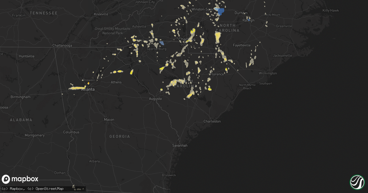
Hail Map in South Carolina on June 16, 2022
Get this storm
June 16 map
$229
one time, instant access
Download today. No call, no setup
Keep the $229
Bought the map and want the full workflow? Apply the entire $229 to a subscription within 7 days. None of it is wasted.
Every map, not just this one
This buys you this map. Subscription and you get every map we run, in the markets you choose from a few cities to whole states to nationwide. Plus real-time alerts the moment a storm fires.
Contact data
Name, contact info, occupancy, even credit band for addresses in the footprint. You go from where it hit to who to call.
Become the source they trust
Unlimited branding weather history reports on demand. You already have the documented answer ready for the property owner, and you are the one who showed up with it.
Property data and RoofTrace estimates
Pull up any address you have got, its value and the exact code rules for that jurisdiction, straight from One Click Code. Then RoofTrace estimates the squares, pitch, and roof value, priced the way you price.
Storm reports in South Carolina
South Carolina
| Date | Description |
|---|---|
| 06/16/20226:59 PM CDT | Tree reported down at the intersection of highway 35 and russellville road. Time estimated by radar. |
| 06/16/20226:35 PM CDT | Sc highway patrol reported trees down at cameron road and mccords ferry road. Time estimated by radar. |
| 06/16/20226:25 PM CDT | Sc highway patrol reported trees down in roadway with all lanes blocked. Time estimated by radar. |
| 06/16/20226:22 PM CDT | Sc highway patrol reported trees down and roadway blocked at wildlife road and wildlife circle. Time estimated. |
| 06/16/20226:18 PM CDT | Dispatch reports trees down along ranchero st at snipes pond rd. |
| 06/16/20226:05 PM CDT | Sc highway patrol reported trees down at lewis road and deejay lane. Time estimated. |
| 06/16/20226:04 PM CDT | The public reported several trees down in olanta and provided video of damage to a large-diameter tree that was split. |
| 06/16/20226:03 PM CDT | Sc highway patrol reported tree in the roadway on live oak rd. Time estimated by radar. |
| 06/16/20226:03 PM CDT | Tree down across north bethel road near the intersection of west camp branch road. |
| 06/16/20226:02 PM CDT | Sc highway patrol reports trees down on megan ct at strawberry ln. |
| 06/16/20226:00 PM CDT | Sc highway patrol reports trees down along i-95 sb at mm132. |
| 06/16/20225:52 PM CDT | Tree down on horrace matthews road near the intersection of poor farm road. |
| 06/16/20225:50 PM CDT | Sc highway patrol reported trees down and roadway blocked at trinity road and mcknight road. Time estimated. |
| 06/16/20225:46 PM CDT | Tree across southborough road near the intersection of century drive. |
| 06/16/20225:34 PM CDT | Tree in roadway on old creek rd and us1. 911 call center. |
| 06/16/20225:30 PM CDT | Tornado confirmed in darlington... Sc... Northeast of lamar. Additional information forthcoming with storm survey results. |
| 06/16/20225:30 PM CDT | Numerous trees and powerlines down across southeast chesterfield co. |
| 06/16/20225:26 PM CDT | Sc highway patrol reports trees down along i-77 near ft jackson. |
| 06/16/20225:26 PM CDT | County dispatch reported trees down along columbia highway at shiloh church rd. |
| 06/16/20225:24 PM CDT | Columbia fire reports multiple collapsed structures along downing st in columbia. |
| 06/16/20225:23 PM CDT | Tree down across us 15 near the railroad avenue cross section. |
| 06/16/20225:22 PM CDT | Corrects previous tstm wnd dmg report from 2 nw red bank. Sc highway patrol reported trees down and roadway blocked at wildlife road and wildlife circle. Time estimated |
| 06/16/20225:18 PM CDT | Sc highway patrol reported trees down along hwy 52 at belton rd. |
| 06/16/20225:16 PM CDT | Sc highway patrol reports trees down on surrey st at magrath st. |
| 06/16/20225:15 PM CDT | Sc highway patrol reported trees down at battleford road and emerald valley road. Time estimated. |
| 06/16/20225:14 PM CDT | Dispatch reports trees down along lakeshore dr. |
| 06/16/20225:10 PM CDT | Sc highway patrol reported tree in the roadway at the intersection of williamsburg dr. And coronado dr. Time estimated by radar. |
| 06/16/20225:10 PM CDT | Sc highway patrol reported tree in the roadway at the intersection of riverhill cir. And broad river rd. Time estimated by radar. |
| 06/16/20225:09 PM CDT | Sc highway patrol reported tree blocking the roadway at the intersection of burning tree dr. And st. Andrews rd. Time estimated by radar. |
| 06/16/20225:09 PM CDT | Sc highway patrol reported tree blocking the roadway at the intersection of browning rd. And zimalcrest dr. Time estimated by radar. |
| 06/16/20225:06 PM CDT | Dispatch reports numerous trees down along hwy 1 in lugoff which took down powerlines. |
| 06/16/20225:00 PM CDT | Sc highway patrol reported tree in the roadway at the intersection of old creek rd. And us 1. Time estimated by radar. |
| 06/16/20225:00 PM CDT | Sc highway patrol reported trees down at crane church and slab pile road. Time estimated by radar. |
| 06/16/20224:59 PM CDT | Dispatch reported numerous trees down along bethune rd near bethune. |
| 06/16/20224:50 PM CDT | Sc highway patrol reports trees down on veterans row and sessions rd. |
| 06/16/20224:40 PM CDT | Tree down on john j richards road at beaver creek. |
| 06/16/20224:33 PM CDT | Sc highway patrol reported tree in roadway at the intersection of craig farm rd. And montgomery rd. Time estimated by radar. |
| 06/16/20224:31 PM CDT | County dispatch reported trees on power lines along baltic circle. |
| 06/16/20224:28 PM CDT | Sc highway patrol reported trees down along cedar grove rd at hwy 1. |
| 06/16/20224:17 PM CDT | Tree down in the city of newberry. |
| 06/16/20224:10 PM CDT | Fairfield county dispatch reported large uprooted trees at the intersection of patrick and 321 in white oak. Time estimated by radar. |
| 06/16/20224:10 PM CDT | County dispatch reported trees and power lines down at multiple locations in the county with widespread power outages along collins rd due to lines down. |
| 06/16/20224:10 PM CDT | Fairfield county dispatch reported trees down along hwy 200 near i-77. |
| 06/16/20224:02 PM CDT | Large tree fell on traveling truck 1.5 miles north of harmony baptist church. |
| 06/16/20223:51 PM CDT | Trees and power lines down county wide. |
| 06/16/20223:50 PM CDT | Newberry county sheriff reported trees down along shingle mill rd at piester rd. |
| 06/16/20223:46 PM CDT | Tree down on piester road |
| 06/16/20223:30 PM CDT | Trees and power lines down county wide. |
| 06/16/20223:19 PM CDT | Trees down city of buffalo. |
| 06/16/20223:14 PM CDT | Trees down in mcconnells. |
| 06/16/20223:14 PM CDT | Trees down in sharon. |
| 06/16/20223:03 PM CDT | Trees down county wide... Some on houses. |
| 06/16/20223:03 PM CDT | Trees down in jonesville. |
| 06/16/20222:45 PM CDT | Trees down. |
| 06/16/20222:45 PM CDT | Trees down. S of downed trees around the city of polkton. Time estimated by |
| 06/16/20222:40 PM CDT | Multiple power lines down along highway 150 in gaffney. |
| 06/16/20222:28 PM CDT | Tree down. |
| 06/16/20222:18 PM CDT | Trees down at this location and 12 other locations around the northeast quadrant of spartanburg county. |
| 06/16/20221:40 PM CDT | Trees uprooted along townsend drive. |
| 06/16/20227:48 AM CDT | At 1248 PM EDT, a severe thunderstorm was located 9 miles northwest of Walhalla, or near Oconee State Park, and is nearly stationary. HAZARD...60 mph wind gusts and quarter size hail. SOURCE...Radar indicated. IMPACT...Minor hail damage to vehicles is expected. Expect wind damage to trees and power lines. Locations impacted include... Oconee State Park, Pine Mountain and Mountain Rest. |
| 06/16/20222:52 AM CDT | At 751 PM EDT, a severe thunderstorm was located near Brookdale, moving south at 25 mph. HAZARD...60 mph wind gusts and penny size hail. SOURCE...Radar indicated. IMPACT...Expect damage to trees and powerlines. Locations impacted include... Orangeburg, Brookdale, St. Matthews, Holly Hill, Branchville, Summerton, Bowman, Elloree, Santee State Park, Santee Cooper Regional Airport, Claflin College, South Carolina State University, Orangeburg County Airport, Edisto Gardens, Santee, Cameron, Eutawville, Rowesville, Vance and Cordova.This includes the following highways... Interstate 26 between mile markers 143 and 169. Interstate 95 between mile markers 85 and 117. |
| 06/16/20222:45 AM CDT | At 744 PM EDT, a severe thunderstorm was located near Holly Hill, moving south at 35 mph. HAZARD...60 mph wind gusts. SOURCE...Radar indicated. IMPACT...Expect damage to trees and powerlines. Locations impacted include: Moncks Corner, Saint George, Dorchester, Ridgeville, Saint Stephen, Harleyville, Bonneau, Reevesville, Smoaks, Cross, Northern Lake Moultrie, Old Santee Canal State Park, Eastern Lake Marion, Canadys and Pinopolis.This warning includes the following interstates: I-26 between mile markers 171 and 194. I-95 in South Carolina between mile markers 68 and 85. |
| 06/16/20222:32 AM CDT | At 732 PM EDT, a severe thunderstorm was located near Summerton, or 15 miles southwest of Manning, moving south at 40 mph. HAZARD...60 mph wind gusts and penny size hail. SOURCE...Radar indicated. IMPACT...Expect damage to trees and powerlines. Locations impacted include... Summerton, Elloree, Santee State Park, Santee Cooper Regional Airport, Santee, Eutawville, Vance, Poplar Creek Landing, Rimini, St. Paul, Stumphole Landing, Rocks Pond Campground and Marina, Eautaw Springs, Indian Bluff Recreation Park, Davis Station, Creston, Blounts Landing, Mill Creek Marina and Campground, Lone Star and Low Falls Landing.This includes the following highways... Interstate 26 between mile markers 161 and 164. Interstate 95 between mile markers 90 and 117. |
| 06/16/20221:59 AM CDT | At 659 PM EDT, a severe thunderstorm was located 7 miles east of Aiken Municipal Airport, or 11 miles northeast of Aiken, moving east at 20 mph. HAZARD...60 mph wind gusts and quarter size hail. SOURCE...Radar indicated. IMPACT...Hail damage to vehicles is expected. Expect wind damage to trees and powerlines. Locations impacted include... Aiken Municipal Airport, Wagener, Perry, Perry Airport, Thor and New Holland.This includes Interstate 20 in South Carolina between mile markers 19and 29. |
| 06/16/20221:56 AM CDT | At 656 PM EDT, a severe thunderstorm was located near Eastover, or 8 miles southwest of Shaw Air Base, moving southeast at 25 mph. HAZARD...60 mph wind gusts and penny size hail. SOURCE...Radar indicated. IMPACT...Expect damage to trees and powerlines. Locations impacted include... Columbia, Sumter, Forest Acres, McEntire Air Base, South Sumter, Shaw Air Base, St. Matthews, Eastover, Congaree National Park, Hopkins, Oakland, Horrel Hill, Mulberry, Sumter County Airport, Gadsden, Millwood, Poinsett State Park, Pinewood, Paxville and Cane Savannah.This includes the following highways... Interstate 26 between mile markers 131 and 137. Interstate 77 between mile markers 7 and 13. Interstate 95 between mile markers 117 and 118. |
| 06/16/20221:43 AM CDT | At 642 PM EDT, a severe thunderstorm was located near Woods Bay State Park, or 13 miles west of Lake City, moving south at 20 mph. HAZARD...60 mph wind gusts and penny size hail. SOURCE...Radar indicated. IMPACT...Expect damage to trees and powerlines. Locations impacted include... Manning, Alcolu, Woods Bay State Park, Elliott, Turbeville, Mayesville, Lynchburg, Brogdon, Foreston, East Sumter, St. Charles, Gable and Shiloh.This includes Interstate 95 between mile markers 118 and 146. |
| 06/16/20221:41 AM CDT | At 641 PM EDT, a severe thunderstorm was located over Timmonsville, or 10 miles southwest of Darlington, moving southeast at 25 mph. HAZARD...60 mph wind gusts and quarter size hail. SOURCE...Radar indicated. IMPACT...Minor hail damage to vehicles is possible. Expect wind damage to trees and power lines. Locations impacted include... Florence, Lake City, Timmonsville, Pamplico, Quinby, Mars Bluff, Cartersville, Florence Darlington Technical College Main Campus, Hebron, New Hope, Sardis, Hyman, Effingham, Francis Marion University, Friendfield, Claussen, Evergreen, Scranton, Coward and Olanta. |
| 06/16/20221:35 AM CDT | At 634 PM EDT, severe thunderstorms were located along a line extending from 6 miles west of Red Bank to Ridge Spring, moving northeast at 10 mph. HAZARD...60 mph wind gusts and penny size hail. SOURCE...Radar indicated. IMPACT...Expect damage to trees and powerlines. Locations impacted include... Gilbert, Summit, Camp Kinard, Steedman, Kneece, Samaria Fire Station and Cedar Pond Campground.This includes Interstate 20 in South Carolina between mile markers 30and 48. |
| 06/16/20221:27 AM CDT | At 627 PM EDT, a severe thunderstorm was located over Five Points, or over Columbia, moving east at 30 mph. HAZARD...60 mph wind gusts and penny size hail. SOURCE...Radar indicated. IMPACT...Expect damage to trees and powerlines. Locations impacted include... Columbia, Lexington, West Columbia, Cayce, Irmo, Forest Acres, Springdale, St. Andrews, Highway 6 at Lake Murray Dam, Red Bank, Dentsville, Oak Grove, South Congaree, Pine Ridge, Gaston, Arcadia Lakes, Columbia International University, Harbison State Forest, Riverbanks Zoo and SC State Farmer's Market.This includes the following highways... Interstate 126 between mile markers 0 and 3. Interstate 20 in South Carolina between mile markers 49 and 73. Interstate 26 between mile markers 100 and 124. Interstate 77 between mile markers 0 and 12, and between milemarkers 19 and 22. |
| 06/16/20221:26 AM CDT | At 625 PM EDT, a severe thunderstorm was located 9 miles south of Biscoe, or 13 miles southeast of Troy, moving south at 15 mph. There is also a north-south oriented line of strong storms from Candor to Diggs also capable of producing severe winds and quarter sized hail. HAZARD...60 mph wind gusts and quarter size hail. SOURCE...Radar indicated. IMPACT...Hail damage to vehicles is expected. Expect wind damage to roofs, siding, and trees. Locations impacted include... Rockingham, Hamlet, Hoffman, Ellerbe, Foxfire, Dobbins Heights, Gibson, Norman, Diggs and Laurel Hill. |
| 06/16/20221:20 AM CDT | At 620 PM EDT, a severe thunderstorm was located over Villages at Sandhill, or 7 miles northeast of Dentsville, moving east at 30 mph. HAZARD...60 mph wind gusts. SOURCE...Radar indicated. IMPACT...Expect damage to trees and powerlines. Locations impacted include... Columbia, Sumter, Forest Acres, Camden, McEntire Air Base, Dentsville, Shaw Air Base, Arcadia Lakes, Lugoff, Hopkins, Oakland, Villages at Sandhill, Elgin, Horrel Hill, Killian, Mulberry, Woodfield, Sesquicentennial State Park, Lake Carolina and Fort Jackson.This includes the following highways... Interstate 20 in South Carolina between mile markers 73 and 120. Interstate 77 between mile markers 7 and 24. |
| 06/16/20221:17 AM CDT | At 617 PM EDT, a severe thunderstorm was located 7 miles east of Carolina Sandhills Wildlife Refuge, or 13 miles north of Hartsville, moving east at 25 mph. HAZARD...60 mph wind gusts and quarter size hail. SOURCE...Radar indicated. IMPACT...Hail damage to vehicles is expected. Expect wind damage to trees and powerlines. Locations impacted include... Carolina Sandhills Wildlife Refuge, Cheraw State Park, Patrick, Cheraw Fish Hatchery, Alligator Fire Station, Middendorf and Bay Springs Fire Station. |
| 06/16/20221:08 AM CDT | At 608 PM EDT, severe thunderstorms were located along a line extending from near Cheraw Municipal Airport to near Cassatt, moving southeast at 20 mph. HAZARD...60 mph wind gusts and quarter size hail. SOURCE...Radar indicated. IMPACT...Minor hail damage to vehicles is possible. Expect wind damage to trees and power lines. Locations impacted include... Bennettsville, Hartsville, Darlington, Mccoll, Lamar, Clio, Mont Clare, Brownsville, Lydia, Darlington Raceway, Swift Creek, Oats, Chavistown, Floyd, Minturn, North Hartsville, Dovesville, Auburn, Wallace and Clyde. |
| 06/16/202212:59 AM CDT | At 559 PM EDT, a severe thunderstorm was located over Red Bank, moving south at 20 mph. HAZARD...60 mph wind gusts and penny size hail. SOURCE...Radar indicated. IMPACT...Expect damage to trees and powerlines. Locations impacted include... Lexington, Irmo, Highway 6 at Lake Murray Dam, Red Bank, Oak Grove, Dreher Island State Park, Pelion, Gilbert, Summit, Lexington County Airport At Pelion, Oswald Park, Shull Island, Bundrick Island, Putnam's Landing, Siesta Cove Marina, Murray, Rocky Point Recreation Area, Peachtree Rock, Edmund and Pine Island.This includes Interstate 20 in South Carolina between mile markers 41and 60. |
| 06/16/202212:55 AM CDT | At 554 PM EDT, severe thunderstorms were located along a line extending from near Westville to near Lugoff, moving southeast at 20 mph. HAZARD...60 mph wind gusts and quarter size hail. SOURCE...Radar indicated. IMPACT...Hail damage to vehicles is expected. Expect wind damage to trees and powerlines. Locations impacted include... Camden, Bishopville, Lake Wateree Dam, Lee State Park, Westville, Longtown, Cassatt, Liberty Hill, Goodale State Park, Lake Wateree State Park, Mcbee, Bethune, Lucknow, North Central High School, Dekalb, North Towne Square Shopping Center, Antioch, Midway Elementary School, Pine Grove Fire Station and Woodward Airfield.This includes Interstate 20 in South Carolina between mile markers115 and 126. |
| 06/16/202212:51 AM CDT | At 550 PM EDT, a severe thunderstorm was located near Edgefield County Airport, or 12 miles north of Aiken, moving west at 5 mph. HAZARD...60 mph wind gusts and quarter size hail. SOURCE...Radar indicated. IMPACT...Hail damage to vehicles is expected. Expect wind damage to trees and powerlines. Locations impacted include... Aiken, Edgefield, Johnston, Aiken Municipal Airport, Edgefield County Airport, Trenton, Strom Thurmond High School, Harmony, Vaucluse and Edgefield Federal Correction Institution.This includes Interstate 20 in South Carolina between mile markers 12and 24. |
| 06/16/202212:47 AM CDT | At 547 PM EDT, a severe thunderstorm was located over Oak Grove, moving southeast at 15 mph. HAZARD...60 mph wind gusts and penny size hail. SOURCE...Radar indicated. IMPACT...Expect damage to trees and powerlines. Locations impacted include... Columbia, West Columbia, Cayce, Irmo, Forest Acres, Springdale, St. Andrews, Oak Grove, Dentsville, South Congaree, Pine Ridge, Gaston, Arcadia Lakes, Columbia International University, Riverbanks Zoo, SC State Farmer's Market, Columbia Metro Airport, SC State Fair Grounds, West Columbia Riverwalk and Sandy Run.This includes the following highways... Interstate 126 between mile markers 0 and 3. Interstate 20 in South Carolina between mile markers 60 and 72. Interstate 26 between mile markers 103 and 125. Interstate 77 between mile markers 0 and 7. |
| 06/16/202212:36 AM CDT | At 535 PM EDT, a severe thunderstorm was located over Elgin, or 10 miles northeast of Dentsville, moving southeast at 15 mph. HAZARD...60 mph wind gusts and quarter size hail. SOURCE...Radar indicated. IMPACT...Hail damage to vehicles is expected. Expect wind damage to trees and powerlines. Locations impacted include... Camden, Lugoff, Lake Carolina, Elgin, Villages at Sandhill, Pine Grove Fire Station and North Towne Square Shopping Center.This includes Interstate 20 in South Carolina between mile markers 82and 99. |
| 06/16/202212:32 AM CDT | At 532 PM EDT, severe thunderstorms were located along a line extending from near Mineral Springs to near Liberty Hill, moving east at 35 mph. HAZARD...60 mph wind gusts and penny size hail. SOURCE...Radar indicated. IMPACT...Expect damage to trees and powerlines. Locations impacted include... Lancaster, Pageland, Kershaw, Chesterfield, Elgin, Heath Springs, USC Lancaster, Irwin, Carolina Sandhills Wildlife Refuge, Mt Pisgah, Buford, Jefferson, Ruby, Mount Croghan, Chesterfield Ruby Middle School, Arrowood Estates, Middendorf, Faith Christian School, Bear Creek Park and Central High School. |
| 06/16/202212:29 AM CDT | At 529 PM EDT, a severe thunderstorm was located 7 miles east of Batesburg-Leesville, moving south at 20 mph. HAZARD...60 mph wind gusts. SOURCE...Radar indicated. IMPACT...Expect damage to trees and powerlines. Locations impacted include... Lexington, Batesburg-Leesville, Highway 6 at Lake Murray Dam, Red Bank, Oak Grove, Gilbert, Summit, Cedar Grove Fire Station, South Shore Marina, Oswald Park, Fredonia, Shull Island, Bundrick Island, Siesta Cove Marina, Murray, Peachtree Rock, Edmund, Camp Kinard, Hollow Creek Public Park and Barr Lake.This includes Interstate 20 in South Carolina between mile markers 39and 59. |
| 06/16/202212:28 AM CDT | At 527 PM EDT, a severe thunderstorm was located over Monticello, or near VC Summer Nuclear Station, moving south at 20 mph. HAZARD...60 mph wind gusts and penny size hail. SOURCE...Radar indicated. IMPACT...Expect damage to trees and powerlines. Locations impacted include... Columbia, Irmo, Winnsboro, VC Summer Nuclear Station, Fairfield County Airport, Monticello, Ballentine, Killian, Blackstock, Harbison State Forest, Blythewood, Ridgeway, Lebanon Fire Station, Lake Murray Marina, Fairfield County Detention Center, Upper Richland Fire Station, Rion, Winnsboro Mills, Fairfield Elementary School and Smallwood.This includes the following highways... Interstate 26 between mile markers 95 and 102. Interstate 77 between mile markers 21 and 51. |
| 06/16/202212:20 AM CDT | At 519 PM EDT, a severe thunderstorm was located near Great Falls, or 12 miles south of Lancaster, moving east at 30 mph. HAZARD...60 mph wind gusts and quarter size hail. SOURCE...Radar indicated. IMPACT...Hail damage to vehicles is expected. Expect wind damage to trees and powerlines. Locations impacted include... Camden, Lake Wateree Dam, Westville, Liberty Hill, Lake Wateree State Park, Longtown, Ridgeway, Dekalb, North Towne Square Shopping Center, Woodward Airfield, Mitford and Lake Wateree near Highway 97. |
| 06/16/202212:13 AM CDT | At 513 PM EDT, a severe thunderstorm was located 7 miles southwest of Blair, or 8 miles northeast of Newberry, moving southeast at 15 mph. HAZARD...60 mph wind gusts and penny size hail. SOURCE...Radar indicated. IMPACT...Expect damage to trees and powerlines. Locations impacted include... Newberry, VC Summer Nuclear Station, Whitmire, Newberry County Airport, Blair, Newberry County Detention Center, US-176 and SC- 34 Crossroads, Henderson Island, Belfast Wildlife Management Area, Maybington Fire Station, Feasterville Fire Station, Bush River Fire Station and Enoree Ranger District Office.This includes Interstate 26 between mile markers 62 and 76. |
| 06/16/202212:08 AM CDT | At 507 PM EDT, a severe thunderstorm was located 5 miles south of Indian Land, or 4 miles north of Van Wyck, moving east at 20 mph. HAZARD...60 mph wind gusts and quarter size hail. SOURCE...Radar indicated. IMPACT...Minor hail damage to vehicles is expected. Expect wind damage to trees and power lines. Locations impacted include... Marshville, Sturdivants, Jaars and Trinity. |
| 06/16/202212:03 AM CDT | At 502 PM EDT, a severe thunderstorm was located over Newberry, moving southeast at 15 mph. HAZARD...60 mph wind gusts and quarter size hail. SOURCE...Radar indicated. IMPACT...Hail damage to vehicles is expected. Expect wind damage to trees and powerlines. Locations impacted include... Newberry, Prosperity, Jenkinsville, Newberry College, Dreher Island State Park, Chapin, Little Mountain, Pomaria, Silverstreet, Peak, Putnam's Landing, White Rock, Rocky Point Recreation Area, Hollywood Elementary School, Chappells Fire Station, Melvin Park, Lighthouse Marina, Stoney Hill, Newberry County Detention Center and Fairview Fire Station.This includes Interstate 26 between mile markers 76 and 95. |
| 06/15/202211:47 PM CDT | At 446 PM EDT, a severe thunderstorm was located near Blackstock, or 10 miles south of Chester, moving south at 20 mph. HAZARD...60 mph wind gusts. SOURCE...Radar indicated. IMPACT...Expect damage to trees and powerlines. Locations impacted include... Winnsboro, VC Summer Nuclear Station, Fairfield County Airport, Monticello, Blackstock, Ridgeway, Rion, Winnsboro Mills, Fairfield Elementary School, Lebanon Fire Station, White Oak and Fairfield County Detention Center.This includes Interstate 77 between mile markers 33 and 50. |
| 06/15/202211:45 PM CDT | At 445 PM EDT, a severe thunderstorm was located 7 miles west of Lancaster, or 4 miles north of Fort Lawn, moving east at 30 mph. HAZARD...60 mph wind gusts and quarter size hail. SOURCE...Radar indicated. IMPACT...Minor hail damage to vehicles is expected. Expect wind damage to trees and power lines. Locations impacted include... Rock Hill, Lesslie, Great Falls, Fort Lawn, Mcconnells, Richburg, Lowrys, Catawba, Blackstock and Edgemoor. |
| 06/15/202211:41 PM CDT | At 441 PM EDT, severe thunderstorms were located along a line extending from 7 miles southeast of Downtown Concord to 8 miles southeast of Uptown Charlotte to 8 miles northwest of Indian Land, moving southeast at 20 mph. HAZARD...60 mph wind gusts and quarter size hail. SOURCE...Radar indicated. IMPACT...Minor hail damage to vehicles is expected. Expect wind damage to trees and power lines. Locations impacted include... Monroe, South Charlotte, Southwest Charlotte, East Charlotte, Matthews, Mint Hill, Indian Trail, Weddington, Stallings and Unionville. |
| 06/15/202211:31 PM CDT | At 430 PM EDT, severe thunderstorms were located along a line extending from Southwest Charlotte to near Richburg, moving east at 25 mph. HAZARD...60 mph wind gusts and penny size hail. SOURCE...Radar indicated. IMPACT...Expect damage to trees and powerlines. Locations impacted include... Lancaster, Indian Land, Kershaw, Elgin, Heath Springs, Andrew Jackson State Park, USC Lancaster, Van Wyck, Irwin, Buford, Bell Town Fire Station, Arrowood Estates, Camp Creek Fire Station, Community of Almond Glen, Antioch, Kirk Air Base, Faith Christian School, Pleasant Hill, Unity Fire Station and Lancaster Mill. |
| 06/15/202211:27 PM CDT | At 427 PM EDT, a severe thunderstorm was located 6 miles southeast of Uptown Charlotte, or near Southpark Mall, moving south at 30 mph. HAZARD...60 mph wind gusts and quarter size hail. SOURCE...Radar indicated. IMPACT...Minor hail damage to vehicles is expected. Expect wind damage to trees and power lines. Locations impacted include... Uptown Charlotte, Central Charlotte, South Charlotte, Southwest Charlotte, East Charlotte, Matthews, Mint Hill, Pineville, Freedom Park and The Plaza. |
| 06/15/202211:26 PM CDT | At 426 PM EDT, a severe thunderstorm was located 8 miles southeast of Union, or 5 miles northwest of Carlisle, moving southeast at 10 mph. HAZARD...60 mph wind gusts and quarter size hail. SOURCE...Radar indicated. IMPACT...Minor hail damage to vehicles is expected. Expect wind damage to trees and power lines. Locations impacted include... Chester, Carlisle, Chester State Park, Leeds, Cornwell, Tuckertown and Santuc. |
| 06/15/202211:17 PM CDT | At 417 PM EDT, a severe thunderstorm was located near Whitmire, or 12 miles north of Newberry, moving southeast at 10 mph. HAZARD...60 mph wind gusts and penny size hail. SOURCE...Radar indicated. IMPACT...Expect damage to trees and powerlines. Locations impacted include... Newberry, VC Summer Nuclear Station, Whitmire, Newberry County Airport, Blair, Newberry County Detention Center, US-176 and SC- 34 Crossroads, Henderson Island, Belfast Wildlife Management Area, Maybington Fire Station, Feasterville Fire Station, Bush River Fire Station and Enoree Ranger District Office.This includes Interstate 26 between mile markers 62 and 76. |
| 06/15/202211:08 PM CDT | At 408 PM EDT, a severe thunderstorm was located 8 miles southeast of Gastonia, or near Steele Creek, moving southeast at 15 mph. HAZARD...60 mph wind gusts and quarter size hail. SOURCE...Radar indicated. IMPACT...Minor hail damage to vehicles is expected. Expect wind damage to trees and power lines. Locations impacted include... Southwest Charlotte, Fort Mill, Pineville, Cramerton, Steele Creek, Carowinds, Lake Wylie, Southpark Mall, Freedom Park and Central Charlotte. |
| 06/15/202210:37 PM CDT | At 337 PM EDT, a severe thunderstorm was located 7 miles northeast of Anderson, or near Williamston, moving east at 15 mph. HAZARD...60 mph wind gusts and quarter size hail. SOURCE...Radar indicated. IMPACT...Minor hail damage to vehicles is expected. Expect wind damage to trees and power lines. Locations impacted include... Belton, Williamston, West Pelzer, Fork Shoals, Broadway Lake, Anderson and Piedmont. |
| 06/15/202210:03 PM CDT | At 303 PM EDT, a severe thunderstorm was located near Easley, moving east at 10 mph. HAZARD...60 mph wind gusts and quarter size hail. SOURCE...Radar indicated. IMPACT...Minor hail damage to vehicles is expected. Expect wind damage to trees and power lines. Locations impacted include... Easley, West Greenville, Berea, Welcome, Cherrydale Point, Furman University, Dacusville, Liberty, Paris Mountain State Park and Greenville Downtown. |
| 06/15/20229:58 PM CDT | At 257 PM EDT, a severe thunderstorm was located 5 miles southwest of Easley, or near Liberty, and is nearly stationary. HAZARD...60 mph wind gusts and quarter size hail. SOURCE...Radar indicated. IMPACT...Minor hail damage to vehicles is expected. Expect wind damage to trees and power lines. Locations impacted include... Easley, Powdersville, Piedmont, Liberty and Norris. |
| 06/15/20229:22 PM CDT | At 222 PM EDT, a severe thunderstorm was located near Pickens, and is nearly stationary. HAZARD...60 mph wind gusts and quarter size hail. SOURCE...Radar indicated. IMPACT...Minor hail damage to vehicles is expected. Expect wind damage to trees and power lines. Locations impacted include... Pickens, Table Rock State Park, Jocassee Gorges, Sunset, Pumpkintown, Dacusville, Nine Times, Liberty and Easley. |
| 06/15/20229:01 PM CDT | At 200 PM EDT, a severe thunderstorm was located 9 miles southwest of Columbus, or 5 miles northeast of Tigerville, moving southeast at 10 mph. HAZARD...60 mph wind gusts and quarter size hail. SOURCE...Radar indicated. IMPACT...Minor hail damage to vehicles is expected. Expect wind damage to trees and power lines. Locations impacted include... Taylors, Landrum, Campobello, Tigerville, Lake Bowen, Lake Robinson, Pleasant Ridge State Park, North Saluda Reservoir, Glassy Mountain and Gowensville. |
| 06/15/20228:15 PM CDT | Tree in roadway at river road and trucklands road. Time estimated from radar. |
| 06/15/20228:15 PM CDT | At 115 PM EDT, a severe thunderstorm was located 11 miles east of Clayton, or 7 miles northwest of Oconee State Park, and is nearly stationary. HAZARD...60 mph wind gusts and quarter size hail. SOURCE...Radar indicated. IMPACT...Minor hail damage to vehicles is expected. Expect wind damage to trees and power lines. Locations impacted include... Highlands, Mountain City, Dillard, Sky Valley, Oconee State Park, Black Rock Mountain State Park, Mountain Rest, Scaly Mountain, Pine Mountain and Clayton. |
| 06/15/20228:08 PM CDT | Tree down in road at treeland drive and loblolly. |
| 06/15/20228:05 PM CDT | Schp reported tree down at bohicket rd and shadow pond rd. Likely due to thunderstorm outflow. Time estimated by radar. |
| 06/15/20227:53 PM CDT | Schp reported a tree down at penny creek dr and rogers ln. Likely due to thunderstorm outflow. Time estimated from radar. |
| 06/15/20227:48 PM CDT | Tree reported down on bates branch road at brewer road. Time estimated from radar. |
| 06/15/20227:46 PM CDT | Tree down at 401 n. Live oak road. |
| 06/15/20227:45 PM CDT | Tree down on powerlines at gravel hill road and harristown road. |
| 06/15/20227:32 PM CDT | Tree down at 401 n. Live oak road. |
| 06/15/20227:31 PM CDT | Sc highway patrol reports a tree down at the intersection of augusta highway and jefferies highway. Time estimated by radar. Damage due to thunderstorm outflow. |
| 06/15/20227:20 PM CDT | Tree down on powerlines at gravel hill road and harristown road. |
| 06/15/20227:19 PM CDT | Sc highway patrol reported a tree on homestead rd. Before the bowman town limit. Time estimated by radar. |
| 06/15/20227:00 PM CDT | Sc highway patrol reported tree down on i95 at mile marker 87sb. Time estimated. |
| 06/15/20227:00 PM CDT | Sc highway patrol reported trees down on i95 at mile marker 88sb. Time estimated. |
All States Impacted by Hail Map on June 16, 2022
Cities Impacted by Hail Map on June 16, 2022
- Fort Covington, NY
- Brushton, NY
- Oswego, NY
- Hannibal, NY
- Fine, NY
- Fulton, NY
- Clay, NY
- Brewerton, NY
- Trenton, MO
- Spickard, MO
- North Bend, PA
- Lock Haven, PA
- Chaumont, NY
- Bellwood, NE
- David City, NE
- Bethany, MO
- Ridgeway, MO
- Martinsville, MO
- Ransomville, NY
- Wilson, NY
- Canandaigua, NY
- Stanley, NY
- Bloomfield, IA
- Moulton, IA
- Verdon, NE
- Salem, NE
- Humboldt, NE
- Falls City, NE
- Dawson, NE
- Lacona, NY
- Sandy Creek, NY
- Pulaski, NY
- Chaffee, NY
- West Valley, NY
- East Concord, NY
- Bliss, NY
- Sardinia, NY
- Springville, NY
- Arcade, NY
- Delevan, NY
- Yorkshire, NY
- Saegertown, PA
- Cambridge Springs, PA
- Hastings, IA
- Johnstown, OH
- Massena, NY
- Gouverneur, NY
- Theresa, NY
- Antwerp, NY
- Fort Drum, NY
- Philadelphia, NY
- Watertown, NY
- Rodman, NY
- La Fargeville, NY
- Abie, NE
- Bruno, NE
- Linwood, NE
- Honeoye Falls, NY
- Victor, NY
- Frederick, IL
- Mount Sterling, IL
- Rushville, IL
- Browning, IL
- Timewell, IL
- Elkhart, IL
- Garden Grove, IA
- Allerton, IA
- Princeton, MO
- Waterford, PA
- Edinboro, PA
- Wattsburg, PA
- Conneaut, OH
- McKean, PA
- Albion, PA
- Girard, PA
- Cranesville, PA
- Union City, PA
- Kingsville, OH
- Erie, PA
- Springboro, PA
- Shortsville, NY
- Palmyra, NY
- Farmington, NY
- Wolbach, NE
- Corning, IA
- Hermon, NY
- Eagleville, MO
- Hatfield, MO
- Cape Vincent, NY
- Clayton, NY
- Pennellville, NY
- Memphis, NY
- Clyde, NY
- Central Square, NY
- Cato, NY
- Jordan, NY
- Red Creek, NY
- Martville, NY
- Savannah, NY
- Wolcott, NY
- Sterling, NY
- Phoenix, NY
- Weedsport, NY
- Port Byron, NY
- Lyons, NY
- Sodus, NY
- North Rose, NY
- Baldwinsville, NY
- Brewster, OH
- Navarre, OH
- Geneseo, NY
- Clifton Springs, NY
- Leicester, NY
- Manchester, NY
- Phelps, NY
- Conesus, NY
- Bloomfield, NY
- Honeoye, NY
- Silver Springs, NY
- Gainesville, NY
- Silver Lake, NY
- Mount Morris, NY
- Perry, NY
- Hemlock, NY
- Castile, NY
- Lima, NY
- Livonia, NY
- Hammond, NY
- De Peyster, NY
- Cattaraugus, NY
- East Otto, NY
- Snow Shoe, PA
- Moshannon, PA
- Drakesville, IA
- Syracuse, NY
- Liverpool, NY
- Conneautville, PA
- Greenville, PA
- Kinsman, OH
- Fowler, OH
- Burghill, OH
- Farmdale, OH
- Howard, OH
- Gambier, OH
- Gilman City, MO
- Kellerton, IA
- Lamoni, IA
- Landisburg, PA
- Sherman, NY
- Findley Lake, NY
- Clymer, NY
- Newark, NY
- Jamesville, NY
- Auburn, NY
- Copenhagen, NY
- Clarence, PA
- Pottersdale, PA
- James City, PA
- Weedville, PA
- Clarendon, PA
- Kersey, PA
- Bellefonte, PA
- Benezett, PA
- Tidioute, PA
- Centerville, PA
- Spartansburg, PA
- Driftwood, PA
- Grand Valley, PA
- Titusville, PA
- Sheffield, PA
- Saint Marys, PA
- Howard, PA
- Pittsfield, PA
- Ridgway, PA
- Johnsonburg, PA
- Sinnamahoning, PA
- Marienville, PA
- Kane, PA
- Tionesta, PA
- Karthaus, PA
- Kersey, CO
- Greeley, CO
- La Salle, CO
- Geneva, NY
- Fremont, IN
- Angola, IN
- Edon, OH
- Warren, OH
- Vienna, OH
- Emlenton, PA
- Masury, OH
- Jackson Center, PA
- Transfer, PA
- Petrolia, PA
- Stoneboro, PA
- Parker, PA
- Mercer, PA
- Eau Claire, PA
- Harrisville, PA
- Rimersburg, PA
- Hermitage, PA
- Fredonia, PA
- Fairmount City, PA
- Clintonville, PA
- Cortland, OH
- Hilliards, PA
- Clark, PA
- West Sunbury, PA
- Karns City, PA
- New Bethlehem, PA
- Boyers, PA
- Grove City, PA
- Sligo, PA
- Sharpsville, PA
- Polk, PA
- Bruin, PA
- Kennerdell, PA
- North Bloomfield, OH
- Chardon, OH
- Huntsburg, OH
- Middlefield, OH
- Novelty, OH
- Chesterland, OH
- Orwell, OH
- Newbury, OH
- Burton, OH
- Windsor, OH
- Gates Mills, OH
- Russell, NY
- Medina, NY
- Middleport, NY
- Richville, NY
- De Kalb Junction, NY
- Redwood, NY
- Grand River, IA
- Albany, MO
- New Hampton, MO
- McFall, MO
- Tingley, IA
- Ellston, IA
- Browning, MO
- Laredo, MO
- Chula, MO
- Humphreys, MO
- Franklin, PA
- Cooperstown, PA
- Eagle Rock, VA
- Clifton Forge, VA
- Mulberry Grove, IL
- Bingham, IL
- Ramsey, IL
- Fillmore, IL
- Coffeen, IL
- Galt, MO
- Renovo, PA
- Statesville, NC
- Glenwood, IA
- Malvern, IA
- Pacific Junction, IA
- Tecumseh, NE
- Rockport, IL
- Pittsfield, IL
- Pleasant Hill, IL
- Benton, IA
- Clearfield, IA
- Bedford, IA
- Blockton, IA
- Rutherfordton, NC
- Chesnee, SC
- Clarence, MO
- Lentner, MO
- Powersville, MO
- Seymour, IA
- Lucerne, MO
- Newtown, MO
- Lineville, IA
- Pollock, MO
- Harris, MO
- Mercer, MO
- Unionville, MO
- Milan, MO
- Corydon, IA
- Clinton, NC
- Richwoods, MO
- Lonedell, MO
- Sullivan, MO
- Hoxie, KS
- Bland, VA
- Alpharetta, GA
- Morrisonville, IL
- Nokomis, IL
- Clover, SC
- Belmont, NC
- Gastonia, NC
- Darlington, SC
- Long Island, VA
- Greencastle, PA
- Clear Spring, MD
- Hagerstown, MD
- Mercersburg, PA
- Pisgah Forest, NC
- High Point, NC
- Jamestown, NC
- Ashland, IL
- Liberty, IL
- Mendenhall, MS
- Salem, WV
- Vesuvius, VA
- Lincolnton, NC
- Maybeury, WV
- Pocahontas, VA
- Bluefield, VA
- Welch, WV
- Bramwell, WV
- Luray, MO
- Queen City, MO
- Gibbs, MO
- Kirksville, MO
- Shelbyville, MO
- Brashear, MO
- Milton, IA
- La Plata, MO
- Cantril, IA
- Baring, MO
- Memphis, MO
- Atlanta, MO
- Hurdland, MO
- Bethel, MO
- Knox City, MO
- Rutledge, MO
- Novinger, MO
- Greentop, MO
- Farmington, IA
- Keosauqua, IA
- Mount Sterling, IA
- Bonaparte, IA
- Novelty, MO
- Kahoka, MO
- Pulaski, IA
- Downing, MO
- Edina, MO
- Arbela, MO
- La Belle, MO
- Lancaster, MO
- Newark, MO
- Green Castle, MO
- Leonard, MO
- Roanoke, VA
- Salem, VA
- Mifflin, PA
- McAlisterville, PA
- McClure, PA
- Millerstown, PA
- Mifflintown, PA
- Shermans Dale, PA
- Port Royal, PA
- Newport, PA
- Oakland Mills, PA
- New Bloomfield, PA
- Duncannon, PA
- Lewistown, PA
- Thompsontown, PA
- Marianna, FL
- Grand Ridge, FL
- Oconee, IL
- Pana, IL
- Six Mile, SC
- Central, SC
- Aldie, VA
- Leesburg, VA
- Gretna, VA
- Chatham, VA
- Java, VA
- West Union, WV
- Bluford, IL
- Dix, IL
- Irvington, IL
- Centralia, IL
- Johnsonville, IL
- Keenes, IL
- Walnut Hill, IL
- Texico, IL
- Kell, IL
- Mount Vernon, IL
- Iuka, IL
- Pelham, NC
- Ruffin, NC
- Reidsville, NC
- Tarkio, MO
- Watson, MO
- Rock Port, MO
- Westboro, MO
- Winston, GA
- Whitesburg, GA
- Clio, SC
- Blenheim, SC
- Bennettsville, SC
- Bentonia, MS
- Benton, MS
- Rapidan, VA
- Reva, VA
- Boston, VA
- Culpeper, VA
- Mitchells, VA
- West, MS
- Sallis, MS
- Elba, AL
- Kinston, AL
- Samson, AL
- Quincy, FL
- Montpelier, VA
- Rockville, VA
- Northport, AL
- Purcellville, VA
- Scarbro, WV
- Mount Hope, WV
- Fayetteville, WV
- Kincaid, WV
- Maidens, VA
- Powhatan, VA
- Palmyra, VA
- Goochland, VA
- Crozier, VA
- Pratts, VA
- Louisa, VA
- Madison, VA
- Columbia, VA
- Barboursville, VA
- Sandy Hook, VA
- Keswick, VA
- Somerset, VA
- Rochelle, VA
- Aroda, VA
- Unionville, VA
- Troy, VA
- Gum Spring, VA
- Radiant, VA
- Ruckersville, VA
- Gordonsville, VA
- Mineral, VA
- Kents Store, VA
- Stanardsville, VA
- State Farm, VA
- Orange, VA
- Bumpass, VA
- Tiger, GA
- Lakemont, GA
- Hardy, VA
- Bessemer City, NC
- Fort Lupton, CO
- Hudson, CO
- Sylacauga, AL
- Talladega, AL
- Goodwater, AL
- Stockport, OH
- Waterford, OH
- Newport, VA
- Union Mills, NC
- Lake Lure, NC
- Tryon, NC
- Mill Spring, NC
- Thomasville, NC
- Winston Salem, NC
- Northfork, WV
- Kimball, WV
- Brookneal, VA
- Nathalie, VA
- Gladys, VA
- Ellerbe, NC
- Emerson, IA
- Red Oak, IA
- Old Fort, NC
- Marion, NC
- Macon, NC
- Warrenton, NC
- Campobello, SC
- Greer, SC
- Landrum, SC
- McBee, SC
- Bethune, SC
- Jefferson, SC
- Dwight, NE
- Browns Summit, NC
- Nashville, NC
- Chattahoochee, FL
- Bainbridge, GA
- Sneads, FL
- Coatsburg, IL
- Camp Point, IL
- Paloma, IL
- Quincy, IL
- Clayton, IL
- Fowler, IL
- Quinton, AL
- Dora, AL
- Cordova, AL
- Marion, SC
- Norwood, LA
- Kershaw, SC
- Covington, VA
- Marble Hill, MO
- Vinton, LA
- Greensboro, NC
- Summerfield, NC
- McLeansville, NC
- Eastover, SC
- Dalzell, SC
- Rembert, SC
- Weeping Water, NE
- Carlisle, SC
- Whitmire, SC
- Newberry, SC
- Union, SC
- Tuskegee, AL
- Camillus, NY
- Warners, NY
- Joanna, SC
- Kinards, SC
- Silverstreet, SC
- Hopkins, SC
- Randolph, AL
- Jemison, AL
- Brierfield, AL
- Norfolk, NY
- Chase Mills, NY
- Friend, NE
- Cordova, NE
- York, NE
- Waco, NE
- McCool Junction, NE
- Exeter, NE
- Beaver Crossing, NE
- Glenmont, OH
- Danville, OH
- Lewistown, MO
- Chesterhill, OH
- Marine, IL
- Alhambra, IL
- Rushville, OH
- Somerset, OH
- Thornville, OH
- Penokee, KS
- Hill City, KS
- Morland, KS
- Baylis, IL
- Versailles, IL
- Griggsville, IL
- Chambersburg, IL
- Orrick, MO
- Lamar, CO
- Gainesville, VA
- Haymarket, VA
- Jonesville, NC
- Hamptonville, NC
- Lerona, WV
- Peterstown, WV
- Pipestem, WV
- Halifax, VA
- Crystal Hill, VA
- Wilson, NC
- Lucama, NC
- McConnells, SC
- Chester, SC
- Trinity, NC
- New Castle, VA
- Elizabethtown, NC
- Garland, NC
- Pinewood, SC
- Summerton, SC
- Bishopville, SC
- Camden, SC
- Cassatt, SC
- Saluda, SC
- Ward, SC
- Picayune, MS
- Troy, AL
- Louisville, AL
- Clayton, AL
- Perkinston, MS
- Smithdale, MS
- Liberty, MS
- Orangeburg, SC
- Cordova, SC
- Warsaw, IL
- Basco, IL
- Golden, IL
- West Point, IL
- Bowen, IL
- Lewisberry, PA
- Etters, PA
- New Cumberland, PA
- Bremen, OH
- Ronceverte, WV
- Sinks Grove, WV
- Alderson, WV
- Estes Park, CO
- Heath, OH
- Granville, OH
- Newark, OH
- Camp Hill, PA
- Summerdale, PA
- Enola, PA
- Marysville, PA
- Mechanicsburg, PA
- Elliottsburg, PA
- Harrisburg, PA
- York Haven, PA
- Lemoyne, PA
- Nashport, OH
- Butler, OH
- Wheeler, IL
- Loveland, CO
- Berthoud, CO
- Webster Springs, WV
- Eskdale, WV
- Gallagher, WV
- Montgomery, WV
- Martinsburg, WV
- Hedgesville, WV
- Hamilton, VA
- Clay City, IL
- Flora, IL
- Hillsboro, IL
- Donnellson, IL
- Philadelphia, MO
- Monroe City, MO
- Crawley, WV
- Smoot, WV
- Rainelle, WV
- Highland, IL
- Pocahontas, IL
- Greenville, IL
- Carlyle, IL
- Breese, IL
- White Sulphur Springs, WV
- Ballard, WV
- Union, WV
- Greenville, WV
- Ripplemead, VA
- Lindside, WV
- Pembroke, VA
- Narrows, VA
- Martinsville, VA
- Patrick Springs, VA
- Bassett, VA
- Fieldale, VA
- Clinton, SC
- Laurens, SC
- Morganton, NC
- Mayesville, SC
- Gable, SC
- Hamer, SC
- Gibson, NC
- Hamlet, NC
- Laurinburg, NC
- Little Rock, SC
- Maxton, NC
- Rowland, NC
- Laurel Hill, NC
- Rockingham, NC
- McColl, SC
- Dillon, SC
- Monroe, NC
- Liberty Hill, SC
- Ridgeway, SC
- Heath Springs, SC
- Blackstock, SC
- Great Falls, SC
- Winnsboro, SC
- Maysville, GA
- Lamar, SC
- Timmonsville, SC
- Lawrenceville, GA
- Suwanee, GA
- Saint Francisville, LA
- Carriere, MS
- Mulga, AL
- Brundidge, AL
- Banks, AL
- Oakdale, LA
- Glenmora, LA
- Quaker City, OH
- Salesville, OH
- Milroy, PA
- Cook, NE
- Fredericktown, OH
- Cleveland, SC
- Marietta, SC
- Pickens, SC
- Evans, CO
- Villisca, IA
- Elliott, IA
- Green City, MO
- Rosebud, MO
- Owensville, MO
- Windsor, IL
- Strasburg, IL
- Neoga, IL
- Raleigh, NC
- Alexander, IL
- Jacksonville, IL
- Lemont, PA
- Huntingdon, PA
- Julian, PA
- Spring Mills, PA
- Centre Hall, PA
- University Park, PA
- State College, PA
- Boalsburg, PA
- Milesburg, PA
- Port Matilda, PA
- Humeston, IA
- Weldon, IA
- Decatur, IA
- Van Wert, IA
- Leon, IA
- Millersport, OH
- Pleasantville, OH
- Thurston, OH
- Baltimore, OH
- Lenox, IA
- Sharpsburg, IA
- Gravity, IA
- Lawndale, NC
- Cherryville, NC
- Udell, IA
- Unionville, IA
- Moravia, IA
- Centerville, IA
- Anabel, MO
- Pinnacle, NC
- Highland, KS
- Reedsville, PA
- Pilot Mountain, NC
- South Boston, VA
- Tribune, KS
- Ararat, NC
- Beardstown, IL
- Harrisburg, NC
- Landis, NC
- Concord, NC
- Charlotte, NC
- Kannapolis, NC
- China Grove, NC
- Matthews, NC
- Pennsboro, WV
- Perryville, MO
- Winchester, VA
- Hull, IL
- Sunset, SC
- Candor, NC
- Jackson Springs, NC
- Robbins, NC
- Seagrove, NC
- Eagle Springs, NC
- Star, NC
- Biscoe, NC
- Lashmeet, WV
- Matoaka, WV
- Beeson, WV
- Rock, WV
- Berkeley Springs, WV
- Lancaster, SC
- Mode, IL
- Stewardson, IL
- Shelbyville, IL
- Girard, IL
- Waggoner, IL
- Farmersville, IL
- Lugoff, SC
- Blythewood, SC
- Columbia, SC
- Elgin, SC
- Danielsville, GA
- Carnesville, GA
- Royston, GA
- Commerce, GA
- Harmony, NC
- Union Grove, NC
- Heflin, AL
- Munford, AL
- Oxford, AL
- Delta, AL
- Anniston, AL
- Alcolu, SC
- Dorchester, NE
- Crete, NE
- Columbus, NC
- Table Rock, NE
- The Plains, VA
- Middleburg, VA
- Rocky Gap, VA
- Bluefield, WV
- Princeton, WV
- Kennesaw, GA
- Marietta, GA
- Jane Lew, WV
- Glenville, WV
- Crawford, WV
- Orlando, WV
- French Creek, WV
- Camden, WV
- Tallmansville, WV
- Buckhannon, WV
- Rock Cave, WV
- Helvetia, WV
- Walkersville, WV
- Adrian, WV
- Horner, WV
- Weston, WV
- New Milton, WV
- Burnsville, WV
- Copen, WV
- Sand Fork, WV
- Linn, WV
- Alum Bridge, WV
- Pickens, WV
- Wytheville, VA
- Ceres, VA
- Ferrum, VA
- Valparaiso, NE
- Brainard, NE
- Ashland, NE
- Cottondale, FL
- Campbellton, FL
- Chipley, FL
- Graceville, FL
- Alford, FL
- Bonifay, FL
- Sebree, KY
- Slaughters, KY
- Calhoun, KY
- New Douglas, IL
- Livingston, IL
- Staunton, IL
- North Tazewell, VA
- Falls Mills, VA
- Bastian, VA
- Alvo, NE
- Murdock, NE
- Greenwood, NE
- Hosford, FL
- Daleville, VA
- Vinton, VA
- Troutville, VA
- Catawba, VA
- Cloverdale, VA
- Travelers Rest, SC
- Benwood, WV
- Mcmechen, WV
- Cameron, WV
- Glen Dale, WV
- Wheeling, WV
- Jacobsburg, OH
- Moundsville, WV
- Bellaire, OH
- Glen Easton, WV
- Shadyside, OH
- Marshville, NC
- Wingate, NC
- Hartsville, SC
- Hurt, VA
- Altavista, VA
- Lynch Station, VA
- Friedheim, MO
- Oak Ridge, MO
- Daisy, MO
- Elon, NC
- Gibsonville, NC
- Newton, NC
- Lyman, SC
- Inman, SC
- Atlanta, GA
- Birmingham, AL
- Docena, AL
- Adamsville, AL
- Vale, NC
- Hickory, NC
- Bristol, FL
- Vernon Hill, VA
- Greenwood, FL
- Brevard, NC
- Belton, SC
- Williamston, SC
- Chancellor, AL
- Stokesdale, NC
- Belews Creek, NC
- Coffee Springs, AL
- Panacea, FL
- Cowpens, SC
- Spartanburg, SC
- Boiling Springs, SC
- Chesterville, OH
- Cardington, OH
- Mount Gilead, OH
- Catawba, SC
- Fort Mill, SC
- Rock Hill, SC
- Edgemoor, SC
- Roebuck, SC
- Pauline, SC
- Gainesville, GA
- Sumter, SC
- Cleveland, GA
- Dallas, GA
- Hiram, GA
- Austell, GA
- Douglasville, GA
- Smyrna, GA
- Temple, GA
- Mableton, GA
- Lithia Springs, GA
- Villa Rica, GA
- Bremen, GA
- Powder Springs, GA
- Blountstown, FL
- Altha, FL
- Mount Vernon, OH
- Utica, OH
- Blacklick, OH
- Pataskala, OH
- Reynoldsburg, OH
- Ponce De Leon, FL
- Middlebourne, WV
- Hacker Valley, WV
- Diana, WV
- Moberly, MO
- Jacksonville, MO
- Holliday, MO
- Centralia, MO
- Madison, MO
- Clark, MO
- Cairo, MO
- Thompson, MO
- Paris, MO
- Shelbina, MO
- Sorento, IL
- Worden, IL
- Huntly, VA
- Front Royal, VA
- Bentonville, VA
- Flint Hill, VA
- Amissville, VA
- Jeffersonton, VA
- Hume, VA
- Marshall, VA
- Chester Gap, VA
- Linden, VA
- Yadkinville, NC
- Boonville, NC
- Frohna, MO
- Santee, SC
- Elloree, SC
- Asheboro, NC
- Claremont, NC
- Stony Point, NC
- Taylorsville, NC
- Faison, NC
- Flowery Branch, GA
- Ruby, SC
- Mount Croghan, SC
- Cumming, GA
- Cloudcroft, NM
- Kellyton, AL
- Alexander City, AL
- Weogufka, AL
- Equality, AL
- Rockford, AL
- Roanoke, LA
- Marksville, LA
- Conover, NC
- Dexter, NY
- Brownville, NY
- Seneca Falls, NY
- Cayuga, NY
- Waterloo, NY
- Cammal, PA
- Oakley, KS
- Boyce, VA
- Brownstown, IL
- Noble, IL
- Abingdon, VA
- Pittsville, VA
- Sandy Level, VA
- Wilkesboro, NC
- Blair, SC
- Lynchburg, SC
- Rosman, NC
- Buford, GA
- Selma, AL
- Tallahassee, FL
- Sopchoppy, FL
- Carrabelle, FL
- Brock, NE
- Talmage, NE
- Belmont, OH
- Sardis, OH
- Cambridge, OH
- Gnadenhutten, OH
- Summerfield, OH
- Powhatan Point, OH
- Adamsville, OH
- New Concord, OH
- Norwich, OH
- Beallsville, OH
- Cadiz, OH
- Barnesville, OH
- Tippecanoe, OH
- Blue Rock, OH
- Conesville, OH
- White Cottage, OH
- Roseville, OH
- Freeport, OH
- Mount Perry, OH
- Hebron, OH
- Wingett Run, OH
- Fresno, OH
- Zanesville, OH
- Coshocton, OH
- Flushing, OH
- Chandlersville, OH
- Warsaw, OH
- Hopewell, OH
- Byesville, OH
- Duncan Falls, OH
- Crooksville, OH
- Kimbolton, OH
- Piedmont, OH
- Newcomerstown, OH
- West Lafayette, OH
- Jerusalem, OH
- Bethesda, OH
- Caldwell, OH
- New Matamoras, OH
- Woodsfield, OH
- Mcconnelsville, OH
- Lore City, OH
- Jacksontown, OH
- Frazeysburg, OH
- Dresden, OH
- Trinway, OH
- Sarahsville, OH
- Philo, OH
- Lewisville, OH
- Lower Salem, OH
- Belle Valley, OH
- Glenford, OH
- Graysville, OH
- Senecaville, OH
- Sistersville, WV
- Cumberland, OH
- Stone Creek, OH
- Dexter City, OH
- Uhrichsville, OH
- Alledonia, OH
- Pleasant City, OH
- Kipling, OH
- Port Washington, OH
- Hiwassee, VA
- Osceola, IA
- Platteville, CO
- Williamsfield, OH
- Andover, OH
- Hartstown, PA
- Jamestown, PA
- Cochranton, PA
- Adamsville, PA
- Atlantic, PA
- Hadley, PA
- Stanberry, MO
- Ravenwood, MO
- Worth, MO
- Gentry, MO
- Herrick, IL
- Chilhowie, VA
- Denver, NC
- Woodburn, IA
- Petersburg, IL
- Mystic, IA
- Melrose, IA
- Philipsburg, PA
- Herndon, WV
- Benton, IL
- Whittington, IL
- Penhook, VA
- Callands, VA
- Uniontown, MO
- Luray, VA
- Woodville, VA
- Sperryville, VA
- Etlan, VA
- Syria, VA
- Wallace, SC
- New Berlin, IL
- Waverly, IL
- Thayer, IL
- Loami, IL
- Auburn, IL
- Glenarm, IL
- Modesto, IL
- Virden, IL
- Chatham, IL
- Pawnee, IL
- Divernon, IL
- Macon, MO
- Crouse, NC
- Batesburg, SC
- Cayce, SC
- West Columbia, SC
- Gilbert, SC
- Leesville, SC
- Pelion, SC
- Lexington, SC
- Jackson, NC
- Alton, VA
- Saint Joseph, MO
- Gold Hill, NC
- Salisbury, NC
- Ingraham, IL
- Louisville, IL
- Farina, IL
- Mason, IL
- Newton, IL
- Edgewood, IL
- Xenia, IL
- Dieterich, IL
- Rinard, IL
- Sandstone, WV
- Hinton, WV
- Pence Springs, WV
- Gore, VA
- Madison, NC
- Poplarville, MS
- Havana, FL
- Blairs, VA
- Sutherlin, VA
- Keeling, VA
- Banco, VA
- Cainsville, MO
- Blythedale, MO
- Williamsburg, WV
- Asbury, WV
- Renick, WV
- Frankford, WV
- Maxwelton, WV
- Lewisburg, WV
- Albemarle, NC
- New London, NC
- Saxe, VA
- Randolph, VA
- Phenix, VA
- Scottsburg, VA
- Clover, VA
- Mocksville, NC
- Durant, MS
- Max Meadows, VA
- Flowood, MS
- Madison, MS
- Brandon, MS
- Ridgeland, MS
- Canton, MS
- Stuart, VA
- Meadows Of Dan, VA
- Woolwine, VA
- Floyd, VA
- Lyons, CO
- Elliston, VA
- Fairmont, NC
- Hayesville, NC
- Bedford, VA
- Thaxton, VA
- Montvale, VA
- Roseboro, NC
- Lebanon, VA
- Kings Mountain, NC
- Altamont, IL
- Effingham, IL
- Shumway, IL
- Beecher City, IL
- Watson, IL
- Teutopolis, IL
- Bessemer, AL
- Dallas, WV
- Triadelphia, WV
- Gerald, MO
- New Haven, MO
- Council, NC
- Kelly, NC
- Whiteville, NC
- Clarkton, NC
- Rocky Mount, VA
- Boones Mill, VA
- Callaway, VA
- Bladenboro, NC
- Land O'Lakes, FL
- Vidor, TX
- Johnston, SC
- Ridge Spring, SC
- Trenton, SC
- Aiken, SC
- Clio, AL
- Brookhaven, MS
- Fair Bluff, NC
- Mize, MS
- Mount Olive, MS
- Highland Home, AL
- Pickrell, NE
- Hallam, NE
- Cortland, NE
- Wilber, NE
- Adams, NE
- Firth, NE
- Clatonia, NE
- Letohatchee, AL
- Roaring River, NC
- Ronda, NC
- North Wilkesboro, NC
- Dobson, NC
- Elkin, NC
- Jennings, LA
- Climax, NC
- Franklinville, NC
- Randleman, NC
- Magnolia, MS
- Summit, MS
- Mayodan, NC
- Pearl River, LA
- Auburn, NE
- Johnson, NE
- Sophia, NC
- Enoree, SC
- Wedgefield, SC
- Liberty, SC
- Easley, SC
- Pendleton, SC
- Salley, SC
- Wagener, SC
- Wilson, LA
- Jackson, LA
- Ethel, LA
- Ashland, OH
- Wooster, OH
- Jeromesville, OH
- Perrysville, OH
- Shreve, OH
- Dundee, OH
- Dover, OH
- Fredericksburg, OH
- Apple Creek, OH
- Leesville, OH
- Carrollton, OH
- Jewett, OH
- Beach City, OH
- Wilmot, OH
- Scio, OH
- Dillonvale, OH
- Bowerston, OH
- Sherrodsville, OH
- Dennison, OH
- Mineral City, OH
- Bolivar, OH
- Hopedale, OH
- Strasburg, OH
- Somerdale, OH
- New Philadelphia, OH
- Bloomingdale, OH
- Mendon, IL
- Payson, IL
- Rosamond, IL
- Pleasant Plains, IL
- Springfield, IL
- Mount Pulaski, IL
- Sigel, IL
- Bunker Hill, IL
- Check, VA
- Shawsville, VA
- Hillsville, VA
- Critz, VA
- Spencer, VA
- Pearisburg, VA
- Christiansburg, VA
- Radford, VA
- Pilot, VA
- Dublin, VA
- Claudville, VA
- Laurel Fork, VA
- Indian Valley, VA
- Dugspur, VA
- Pulaski, VA
- Sandy Ridge, NC
- Willis, VA
- Eggleston, VA
- Copper Hill, VA
- Riner, VA
- Westfield, NC
- Ararat, VA
- Lawsonville, NC
- Blacksburg, VA
- Pleasant Garden, NC
- Julian, NC
- Peachland, NC
- Polkton, NC
- Norwood, NC
- Oakboro, NC
- Locust, NC
- Sautee Nacoochee, GA
- Bowdon, GA
- Spring Hill, FL
- Centreville, MS
- Promise City, IA
- Millersburg, OH
- Killbuck, OH
- Grant City, MO
- New Market, IA
- Loraine, IL
- Tower Hill, IL
- Meadow Creek, WV
- Beaver, WV
- Meadow Bridge, WV
- Shady Spring, WV
- Huntsville, MO
- Higbee, MO
- Richmond, MO
- Rayville, MO
- Hardin, MO
- Hot Springs, VA
- Warm Springs, VA
- Bacova, VA
- Woodson, IL
- Murrayville, IL
- Franklin, IL
- Saint Marys, WV
- Miami, MO
- Dittmer, MO
- Wayne City, IL
- Durham, NC
- Robinson, KS
- Kernersville, NC
- Colfax, NC
- Sherrills Ford, NC
- Catawba, NC
- Burlington, NC
- Chesterfield, SC
- Danville, VA
- Dry Fork, VA
- Latta, SC
- Sellers, SC
- Ringgold, VA
- McConnellsburg, PA
- Norlina, NC
- Nodaway, IA
- Braxton, MS
- Mount Erie, IL
- Fletcher, MO
- Blackwell, MO
- Manning, SC
- Martell, NE
- Sprague, NE
- Roca, NE
- Lincoln, NE
- Denton, NE
- Virginia, IL
- Tallula, IL
- Camp Creek, WV
- Spanishburg, WV
- Flat Top, WV
- New Zion, SC
- Kingstree, SC
- Greensburg, LA
- West Blocton, AL
- Centreville, AL
- Spout Spring, VA
- Pamplin, VA
- Cullen, VA
- Red House, VA
- Charlotte Court House, VA
- Appomattox, VA
- Concord, VA
- Abita Springs, LA
- Bush, LA
- Covington, LA
- Louisburg, NC
- Castalia, NC
- Helen, GA
- Mount Airy, NC
- Gladstone, VA
- Waxhaw, NC
- Rockmart, GA
- Monetta, SC
- Kosciusko, MS
- Wesson, MS
- Nehawka, NE
- Avoca, NE
- Henderson, IA
- Stanton, IA
- Newport, OH
- Neffs, OH
- Reader, WV
- Marietta, OH
- Cameron, OH
- Saint Clairsville, OH
- Friendly, WV
- Beverly, OH
- Reno, OH
- Whipple, OH
- Macksburg, OH
- Clarington, OH
- Littleton, WV
- Plainfield, OH
- New Martinsville, WV
- Malta, OH
- Lowell, OH
- Buckeye Lake, OH
- Alma, WV
- New Lexington, OH
- Baltic, OH
- Coal Run, OH
- Proctor, WV
- Auxvasse, MO
- Kingdom City, MO
- Slatyfork, WV
- Valley Head, WV
- Monterville, WV
- Dallas, NC
- Iron Station, NC
- Stanley, NC
- Goodview, VA
- Moneta, VA
- Dewy Rose, GA
- Hartwell, GA
- Iva, SC
- Elberton, GA
- Cottonwood, AL
- Slocomb, AL
- Dothan, AL
- Mansfield, OH
- Hiawatha, KS
- Morrill, KS
- Mount Ayr, IA
- Craig, MO
- Rulo, NE
- Walhonding, OH
- Redding, IA
- Sheridan, MO
- Dawson, IL
- Buffalo, IL
- Williamsville, IL
- Sherman, IL
- Riverton, IL
- Cass, WV
- Marlinton, WV
- Oak Hill, WV
- Skipwith, VA
- Red Oak, VA
- Clarksville, VA
- Charles Town, WV
- Fairfax, MO
- Skidmore, MO
- Groveport, OH
- Carroll, OH
- Canal Winchester, OH
- Pickerington, OH
- Columbus, OH
- Grove City, OH
- Madison Heights, VA
- Lynchburg, VA
- Maben, WV
- Slab Fork, WV
- Flat Rock, IL
- Robinson, IL
- Sumner, IL
- Oblong, IL
- Ireland, WV
- Cameron, SC
- Saint Matthews, SC
- Bridgeton, MO
- Saint Louis, MO
- Saint Ann, MO
- Pageland, SC
- Marion, VA
- Sugar Grove, VA
- Attapulgus, GA
- Cedar Mountain, NC
- Zirconia, NC
- Harrells, NC
- Nebraska City, NE
- Hamburg, IA
- Goodman, MS
- Lake Toxaway, NC
- Green Sulphur Springs, WV
- Beckley, WV
- Goshen, AL
- Fairfield, VA
- Raphine, VA
- Ulysses, NE
- Surprise, NE
- Shubert, NE
- Milford, NE
- Clarks, NE
- Syracuse, NE
- Sterling, NE
- Davey, NE
- Columbus, NE
- Peru, NE
- Springfield, NE
- Manley, NE
- Brownville, NE
- Belgrade, NE
- Murray, NE
- Benedict, NE
- Garland, NE
- Wahoo, NE
- Burr, NE
- Eagle, NE
- Lorton, NE
- Stromsburg, NE
- Weston, NE
- Louisville, NE
- Plattsmouth, NE
- Nemaha, NE
- Palmyra, NE
- Elmwood, NE
- Julian, NE
- Goehner, NE
- Ceresco, NE
- Duncan, NE
- Fullerton, NE
- Raymond, NE
- Osceola, NE
- Stella, NE
- Utica, NE
- Pleasant Dale, NE
- Waverly, NE
- Ithaca, NE
- Shelby, NE
- Otoe, NE
- Polk, NE
- Seward, NE
- Rising City, NE
- Hickman, NE
- Dunbar, NE
- Genoa, NE
- Staplehurst, NE
- Walton, NE
- Monroe, NE
- Unadilla, NE
- Silver Creek, NE
- Gresham, NE
- Malcolm, NE
- Bennet, NE
- Bee, NE
- Junction City, OH
- Bogard, MO
- Troutman, NC
- Donalsonville, GA
- Spencer, NC
- Headland, AL
- Midland City, AL
- Newville, AL
- Clayton, GA
- Mountain Rest, SC
- Mooresboro, NC
- Lancaster, OH
- Ewing, MO
- Mendon, MO
- Olin, NC
- Hayesville, OH
- Loudonville, OH
- Holmesville, OH
- Rayland, OH
- Dellroy, OH
- Sugarcreek, OH
- Adena, OH
- Rochester, IL
- Craigsville, WV
- Fenwick, WV
- Nettie, WV
- Wolfcreek, WV
- Wayside, WV
- Virgilina, VA
- Briggsdale, CO
- Indian Trail, NC
- Fort Lawn, SC
- Lincoln, AL
- Eastaboga, AL
- Folsom, LA
- Tuckasegee, NC
- Lutz, FL
- Grand Chenier, LA
- Machias, NY
- Zoar, OH
- Layland, WV
- Mannsville, NY
- Gaffney, SC
- Wathena, KS
- Easton, MO
- Mound City, MO
- Fillmore, MO
- Forest City, MO
- Amazonia, MO
- Oregon, MO
- Troy, KS
- Savannah, MO
- Graham, NC
- Haw River, NC
- Efland, NC
- Chapel Hill, NC
- Mebane, NC
- Liberty, NC
- Whitsett, NC
- Palmyra, MO
- New London, MO
- Kinderhook, IL
- Emden, MO
- Hannibal, MO
- Hunnewell, MO
- Frankford, MO
- Barry, IL
- New Salem, IL
- Center, MO
- New Canton, IL
- Bath, IL
- Oakford, IL
- Chandlerville, IL
- East Saint Louis, IL
- Chesterfield, MO
- Caseyville, IL
- Fairview Heights, IL
- Lovejoy, IL
- Maryland Heights, MO
- Venice, IL
- Earth City, MO
- Granite City, IL
- Hazelwood, MO
- Belleville, IL
- O'Fallon, IL
- Collinsville, IL
- Madison, IL
- Taylor Springs, IL
- Butler, IL
- Saint Elmo, IL
- Litchfield, IL
- Irving, IL
- Parkersburg, IL
- West Salem, IL
- Kinmundy, IL
- Sailor Springs, IL
- Olney, IL
- Dundas, IL
- Sims, IL
- Geff, IL
- Ellery, IL
- Cisne, IL
- Golden Gate, IL
- Albion, IL
- Fairfield, IL
- Boydton, VA
- Buffalo Junction, VA
- Chase City, VA
- Wylliesburg, VA
- Smithfield, OH
- Locust Dale, VA
- Longmont, CO


