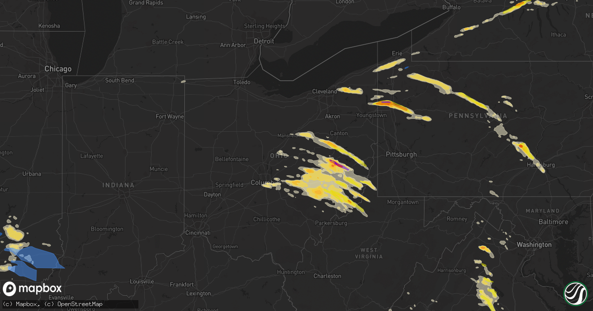
Hail Map in Ohio on June 16, 2022
Get this storm
June 16 map
$229
one time, instant access
Download today. No call, no setup
Keep the $229
Bought the map and want the full workflow? Apply the entire $229 to a subscription within 7 days. None of it is wasted.
Every map, not just this one
This buys you this map. Subscription and you get every map we run, in the markets you choose from a few cities to whole states to nationwide. Plus real-time alerts the moment a storm fires.
Contact data
Name, contact info, occupancy, even credit band for addresses in the footprint. You go from where it hit to who to call.
Become the source they trust
Unlimited branding weather history reports on demand. You already have the documented answer ready for the property owner, and you are the one who showed up with it.
Property data and RoofTrace estimates
Pull up any address you have got, its value and the exact code rules for that jurisdiction, straight from One Click Code. Then RoofTrace estimates the squares, pitch, and roof value, priced the way you price.
Storm reports in Ohio
Ohio
| Date | Description |
|---|---|
| 06/16/20226:38 PM CDT | Tree down. |
| 06/16/20226:32 PM CDT | A local report indicates 1.50 inch wind near 1 SE GRAYSVILLE |
| 06/16/20226:30 PM CDT | Range of sizes from dime to half dollar accompanied by very strong wind |
| 06/16/20226:18 PM CDT | A local report indicates 1.00 inch wind near STAFFORD |
| 06/16/20226:18 PM CDT | Damage to outbuilding observed from thunderstorm wind. |
| 06/16/20225:01 PM CDT | A local report indicates 1.00 inch wind near 1 SSE QUAKER CITY |
| 06/16/20224:55 PM CDT | Trees down on old national road |
| 06/16/20224:45 PM CDT | A local report indicates 1.00 inch wind near BETHESDA |
| 06/16/20224:36 PM CDT | A local report indicates 1.00 inch wind near BARNESVILLE |
| 06/16/20224:27 PM CDT | Report of tree down on old national road. Time estimated based on radar. |
| 06/16/20224:20 PM CDT | Trees down on mt hermon road and beeham run road both near cambridge via county dispatch |
| 06/16/20224:11 PM CDT | A local report indicates 1.00 inch wind near MOOREFIELD |
| 06/16/20224:00 PM CDT | A number of trees down. |
| 06/16/20224:00 PM CDT | A local report indicates 1.00 inch wind near WEST CHESTER |
| 06/16/20223:52 PM CDT | A local report indicates 1.50 inch wind near 3 NW WEST CHESTER |
| 06/16/20223:51 PM CDT | Tree damage along window road reported to ema by residents |
| 06/16/20223:39 PM CDT | Report of multiple trees and power lines down in the area. |
| 06/16/20223:36 PM CDT | A local report indicates 1.25 inch wind near JEWETT |
| 06/16/20223:33 PM CDT | Numerous trees and wires down in the ne portion of trumbull county. Time estimated from radar. |
| 06/16/20223:26 PM CDT | A local report indicates 1.50 inch wind near PORT WASHINGTON |
| 06/16/20223:26 PM CDT | Em passing along report of estimated baseball size hail. |
| 06/16/20223:17 PM CDT | Large tree limbs/branches down |
| 06/16/20223:16 PM CDT | Multiple trees and powerlines down in mesopotamia. Route 534 is closed south of route 87. Time estimated from radar. |
| 06/16/20223:16 PM CDT | Tree down across route 534 about a half mile north of mesopatamia. It also took down power lines. |
| 06/16/20223:12 PM CDT | Report of multiple trees and power lines down in the area. |
| 06/16/20223:04 PM CDT | A local report indicates 1.00 inch wind near SHERRODSVILLE |
| 06/16/20223:00 PM CDT | A local report indicates 1.00 inch wind near DOVER |
| 06/16/20222:53 PM CDT | Numerous trees and powerlines down in mt. Vernon and danville. A transformer was also on fire in mt. Vernon. Time estimated from radar. |
| 06/16/20222:45 PM CDT | Power lines down |
| 06/16/20222:45 PM CDT | Report of multiple trees down around dover. Damage not considered excessive. |
| 06/16/20222:38 PM CDT | One tree snapped in the jeffco lakes part of andover. Time estimated from radar. |
| 06/16/20222:38 PM CDT | One tree snapped in the jeffco lakes part of andover. Time estimated from radar. |
| 06/16/20222:37 PM CDT | Tree down across n. Crater ave. Near e. 7th street |
| 06/16/20222:35 PM CDT | A local report indicates 1.75 inch wind near STRASBURG |
| 06/16/20222:34 PM CDT | A local report indicates 1.25 inch wind near STRASBURG |
| 06/16/20222:33 PM CDT | Delayed report - quarter inch hail. |
| 06/16/20222:26 PM CDT | Report of wind damage to a church. |
| 06/16/20222:24 PM CDT | Numerous trees and powerlines down in the ne part of the county. |
| 06/16/20222:18 PM CDT | Estimated golf ball sized hail. Time estimated via radar. |
| 06/16/20221:55 PM CDT | Several trees and wires down in smithville... New pittsburg... And s of wooster. Time estimated from radar. |
| 06/16/20221:47 PM CDT | Numerous trees and wires down on butternut road in burton. Also a house fire on the burton square possibly related to lightning. Time estimated from radar. |
| 06/16/20221:47 PM CDT | A few trees down in the burton area. Time estimated from radar. |
| 06/16/20221:47 PM CDT | Numerous trees and wires down on butternut road in burton. Also a house fire on the burton square possibly related to lightning. Time estimate |
| 06/16/20221:42 PM CDT | Golf ball sized hail. |
| 06/16/20221:40 PM CDT | Quarter sized hail near aquilla rd and mayfield rd. |
| 06/16/20224:06 AM CDT | At 905 PM EDT, a severe thunderstorm was located near Caldwell, moving southeast at 20 mph. HAZARD...60 mph wind gusts and quarter size hail. SOURCE...Radar indicated. IMPACT...Hail damage to vehicles is expected. Expect wind damage to roofs, siding, and trees. Locations impacted include... Macksburg and Lower Salem. This includes Interstate 77 in Ohio between mile markers 9 and 17. |
| 06/16/20224:03 AM CDT | At 903 PM EDT, a severe thunderstorm was located near Caldwell, moving southeast at 35 mph. HAZARD...60 mph wind gusts and quarter size hail. SOURCE...Radar indicated. IMPACT...Minor hail damage to vehicles is possible. Expect wind damage to trees and power lines, resulting in some power outages. Locations impacted include... Caldwell, Dudley, Dexter City, and Harriettsville. |
| 06/16/20223:33 AM CDT | At 832 PM EDT, a severe thunderstorm was located near New Lexington, moving southeast at 30 mph. HAZARD...60 mph wind gusts and quarter size hail. SOURCE...Radar indicated. IMPACT...Hail damage to vehicles is expected. Expect wind damage to roofs, siding, and trees. Locations impacted include... New Lexington, Glouster, McConnelsville, Shawnee, Chesterhill, New Straitsville, Malta, Corning, Jacksonville, Trimble, Hemlock, Amesville, Rendville and Burr Oak State Park. |
| 06/16/20223:20 AM CDT | At 820 PM EDT, a severe thunderstorm was located over St. Marys, moving southeast at 35 mph. HAZARD...60 mph wind gusts and quarter size hail. SOURCE...Radar indicated. IMPACT...Hail damage to vehicles is expected. Expect wind damage to roofs, siding, and trees. Locations impacted include... Harrisville, St. Marys, Pennsboro, Belmont, North Bend State Park, Newport, Matamoras, Ellenboro, Cairo, Pullman, Friendly, Greenwood, Smithville, Maxwell, Schultz, Arvilla, Point Lookout, New Matamoras, Wick and Mountain.This includes Route 50 in West Virginia between mile markers 28 and51. |
| 06/16/20223:04 AM CDT | At 804 PM EDT, a severe thunderstorm was located near Bremen, or 7 miles west of Somerset, moving southeast at 35 mph. HAZARD...60 mph wind gusts and quarter size hail. SOURCE...Radar indicated. IMPACT...Hail damage to vehicles is expected. Expect wind damage to roofs, siding, and trees. Locations impacted include... New Lexington, Somerset, Shawnee, Perry State Forest, Crooksville, Junction City, Corning, Hemlock and Rendville. |
| 06/16/20223:01 AM CDT | At 801 PM EDT, a severe thunderstorm was located near Pleasantville, moving east at 45 mph. HAZARD...60 mph wind gusts and penny size hail. SOURCE...Radar indicated. IMPACT...Expect damage to trees and power lines. Locations impacted include... Lancaster, Bremen, Pleasantville, Rushville, West Rushville and North Berne. |
| 06/16/20222:43 AM CDT | At 742 PM EDT, severe thunderstorms were located along a line extending from near Caldwell to 8 miles northwest of McConnelsville, moving southeast at 25 mph. HAZARD...60 mph wind gusts and half dollar size hail. SOURCE...Radar indicated. IMPACT...Hail damage to vehicles is expected. Expect wind damage to roofs, siding, and trees. Locations impacted include... McConnelsville, Beverly, Malta, Stockport, Bristol, Macksburg, Lower Salem, Eagleport and Hackney.This includes Interstate 77 in Ohio between mile markers 11 and 17. |
| 06/16/20222:19 AM CDT | At 719 PM EDT, severe thunderstorms were located along a line extending from 10 miles southwest of Byesville to 7 miles east of Perry State Forest, moving east-southeast at 40 mph. HAZARD...60 mph wind gusts and quarter size hail. SOURCE...Radar indicated. IMPACT...Hail damage to vehicles is expected. Expect wind damage to roofs, siding, and trees. Locations impacted include... Bristol and Eagleport. |
| 06/16/20222:10 AM CDT | At 710 PM EDT, a severe thunderstorm was located near Woodsfield, moving southeast at 30 mph. HAZARD...60 mph wind gusts and half dollar size hail. SOURCE...Radar indicated. IMPACT...Minor hail damage to vehicles is possible. Expect wind damage to trees and power lines, resulting in some power outages. Locations impacted include... New Martinsville, Woodsfield, Pine Grove, Sardis, Beallsville, Clarington, Cameron, Wileyville, Proctor, Reader, Porters Falls, and Hannibal. |
| 06/16/20221:52 AM CDT | At 652 PM EDT, severe thunderstorms were located along a line extending from near South Zanesville to near Pleasantville, moving east at 25 mph. HAZARD...60 mph wind gusts and quarter size hail. SOURCE...Radar indicated. IMPACT...Hail damage to vehicles is expected. Expect wind damage to roofs, siding, and trees. Locations impacted include... Somerset, Perry State Forest, Crooksville, Junction City and Glenford. |
| 06/16/20221:33 AM CDT | At 632 PM EDT, a severe thunderstorm was located near Byesville, or near Cambridge, moving southeast at 40 mph. HAZARD...60 mph wind gusts and quarter size hail. SOURCE...Radar indicated. IMPACT...Minor hail damage to vehicles is possible. Expect wind damage to trees and power lines, resulting in some power outages. Locations impacted include... Cambridge, Caldwell, New Concord, Byesville, Pleasant City, Cumberland, Summerfield, Belle Valley, Sarahsville, Norwich, Wolf Run State Park, and Salt Fork State Park. |
| 06/16/202212:45 AM CDT | At 545 PM EDT, a severe thunderstorm was located near Barnesville, moving southeast at 35 mph. HAZARD...60 mph wind gusts and half dollar size hail. SOURCE...Radar indicated. IMPACT...Minor hail damage to vehicles is possible. Expect wind damage to trees and power lines, resulting in some power outages. Locations impacted include... Wheeling, Moundsville, Martins Ferry, St. Clairsville, Bellaire, Barnesville, Bethlehem, Triadelphia, Shadyside, McMechen, Powhatan Point, and Glen Dale. |
| 06/16/202212:43 AM CDT | At 542 PM EDT, a severe thunderstorm was located near Byesville, or near Cambridge, moving southeast at 35 mph. HAZARD...60 mph wind gusts and quarter size hail. SOURCE...Radar indicated. IMPACT...Minor hail damage to vehicles is possible. Expect wind damage to trees and power lines, resulting in some power outages. Locations impacted include... Cambridge, Barnesville, Woodsfield, Byesville, Quaker City, Senecaville, Beallsville, Lore City, Old Washington, Lewisville, Jerusalem, and Salesville. |
| 06/15/202211:58 PM CDT | At 458 PM EDT, a severe thunderstorm was located near Dresden, or 8 miles southwest of Coshocton, moving east at 30 mph. HAZARD...60 mph wind gusts and half dollar size hail. SOURCE...Radar indicated. IMPACT...Minor hail damage to vehicles is possible. Expect wind damage to trees and power lines, resulting in some power outages. Locations impacted include... Coshocton, Cambridge, New Concord, Byesville, Dresden, Antrim, Senecaville, Conesville, Lore City, Old Washington, Plainfield, and Otsego. |
| 06/15/202211:42 PM CDT | At 442 PM EDT, a severe thunderstorm was located near West Lafayette, or near Coshocton, moving east at 45 mph. HAZARD...60 mph wind gusts and quarter size hail. SOURCE...Radar indicated. IMPACT...Minor hail damage to vehicles is possible. Expect wind damage to trees and power lines, resulting in some power outages. Locations impacted include... Coshocton, Newcomerstown, West Lafayette, Dresden, Frazeysburg, Baltic, Port Washington, Conesville, Stone Creek, Plainfield, Otsego, and Chili. |
| 06/15/202211:34 PM CDT | At 433 PM EDT, a severe thunderstorm was located near Newcomerstown, or 9 miles southwest of Uhrichsville, moving southeast at 30 mph. HAZARD...Golf ball size hail and 60 mph wind gusts. SOURCE...Radar indicated. IMPACT...People and animals outdoors will be injured. Expect hail damage to roofs, siding, windows, and vehicles. Expect wind damage to trees and power lines, resulting in some power outages. Locations impacted include... Uhrichsville, Barnesville, Cadiz, Freeport, Newcomerstown, Dennison, Gnadenhutten, Bethesda, Antrim, Tuscarawas, Flushing, and Adena. |
| 06/15/202211:05 PM CDT | At 404 PM EDT, severe thunderstorms were located along a line extending from near Farmerstown to near Gambier, moving east at 40 mph. HAZARD...60 mph wind gusts and half dollar size hail. SOURCE...Radar indicated. IMPACT...Minor hail damage to vehicles is possible. Expect wind damage to trees and power lines, resulting in some power outages. Locations impacted include... Coshocton, Uhrichsville, Newcomerstown, West Lafayette, Dresden, Frazeysburg, Gnadenhutten, Tuscarawas, Baltic, Warsaw, Port Washington, and Conesville. |
| 06/15/202210:58 PM CDT | At 358 PM EDT, a severe thunderstorm was located near Middlefield, or 10 miles southeast of Chardon, moving east at 40 mph. HAZARD...Ping pong ball size hail and 60 mph wind gusts. SOURCE...Radar indicated. IMPACT...People and animals outdoors will be injured. Expect hail damage to roofs, siding, windows, and vehicles. Expect damage to trees and power lines. Locations impacted include... Cortland, Middlefield, North Bloomfield, Orwell, Burton, West Farmington, Bristolville, Huntsburg, Claridon, Mecca, Roaming Shores and Aquilla. |
| 06/15/202210:50 PM CDT | At 350 PM EDT, a severe thunderstorm was located over Centerburg, moving east at 40 mph. HAZARD...60 mph wind gusts and nickel size hail. SOURCE...Radar indicated. IMPACT...Expect damage to trees and power lines. Locations impacted include... Newark, Utica, Hanover, Hartford, St. Louisville, Fredonia, US Route 62 at State Route 661, Fallsburg and Purity. |
| 06/15/202210:46 PM CDT | At 346 PM EDT, a severe thunderstorm was located over Dover, moving east at 30 mph. HAZARD...Two inch hail and 60 mph wind gusts. SOURCE...Radar indicated. IMPACT...People and animals outdoors will be injured. Expect hail damage to roofs, siding, windows, and vehicles. Expect wind damage to trees and power lines, resulting in some power outages. Locations impacted include... New Philadelphia, Dover, Uhrichsville, Cadiz, Carrollton, Dennison, Bolivar, Scio, Midvale, Mineral City, Jewett, and Bergholz. |
| 06/15/202210:34 PM CDT | At 334 PM EDT, a severe thunderstorm was located over Glenmont, or 10 miles west of Millersburg, moving east at 25 mph. HAZARD...60 mph wind gusts and half dollar size hail. SOURCE...Radar indicated. IMPACT...Minor hail damage to vehicles is possible. Expect wind damage to trees and power lines, resulting in some power outages. Locations impacted include... New Philadelphia, Dover, Newcomerstown, West Lafayette, Sugarcreek, Baltic, Warsaw, Port Washington, Stone Creek, Nellie, Chili, and Walhonding. |
| 06/15/202210:19 PM CDT | At 319 PM EDT, a severe thunderstorm was located near Cortland, or 9 miles northwest of Sharpsville, moving east at 35 mph. HAZARD...Ping pong ball size hail and 60 mph wind gusts. SOURCE...Radar indicated. IMPACT...People and animals outdoors will be injured. Expect hail damage to roofs, siding, windows, and vehicles. Expect damage to trees and power lines. Locations impacted include... Cortland, Vienna Center, Girard, Vienna, Yankee Lake, Brookfield Center and West Hill. |
| 06/15/202210:18 PM CDT | At 318 PM EDT, a severe thunderstorm was located near Kinsman, or 17 miles north of Warren, moving east at 40 mph. HAZARD...60 mph wind gusts and quarter size hail. SOURCE...Radar indicated. IMPACT...Minor hail damage to vehicles is possible. Expect wind damage to trees and power lines, resulting in some power outages. Locations impacted include... Hermitage, Sharon, Grove City, Sharpsville, Greenville, Mercer, Stoneboro, Sandy Lake, Clark, Jamestown, Fredonia, and Jackson Center. |
| 06/15/202210:16 PM CDT | At 315 PM EDT, severe thunderstorms were located along a line extending from Nashville to near Waldo, moving east-southeast at 30 mph. HAZARD...60 mph wind gusts and quarter size hail. SOURCE...Radar indicated. IMPACT...Minor damage to vehicles is possible. Expect damage to trees and power lines. Locations impacted include... Mount Vernon, Millersburg, Berlin, Walnut Creek, Loudonville, Fredericktown, Gambier, Sugarcreek, Cardington, Centerburg, Ashley, Prospect, Danville, Killbuck, Waldo, Glenmont, Chesterville, Nashville, Sparta and Farmerstown. |
| 06/15/202210:07 PM CDT | At 307 PM EDT, a severe thunderstorm was located near Mount Eaton, or 10 miles southeast of Wooster, moving east at 40 mph. HAZARD...60 mph wind gusts and quarter size hail. SOURCE...Radar indicated. IMPACT...Minor hail damage to vehicles is possible. Expect wind damage to trees and power lines, resulting in some power outages. Locations impacted include... New Philadelphia, Dover, Strasburg, Malvern, Bolivar, Mineral City, Dellroy, Sherrodsville, Parral, Zoar, Atwood Lake, and Leesville Lake Park. |
| 06/15/202210:02 PM CDT | At 302 PM EDT, a severe thunderstorm was located near Holmesville, or 8 miles north of Millersburg, moving east at 45 mph. HAZARD...60 mph wind gusts and half dollar size hail. SOURCE...Radar indicated. IMPACT...People and animals outdoors will be injured. Expect hail damage to roofs, siding, windows, and vehicles. Expect damage to trees and power lines. Locations impacted include... Wooster, Massillon, Minerva, Brewster, Navarre, Shreve, Waynesburg, East Sparta, Holmesville, Wilmot, Mount Eaton, Winesburg, Apple Creek, Beach City, Fredericksburg, Robertsville and Mount Hope. |
| 06/15/20229:50 PM CDT | At 250 PM EDT, a severe thunderstorm was located near Middlefield, or 11 miles east of Chardon, moving east at 45 mph. HAZARD...Ping pong ball size hail and 60 mph wind gusts. SOURCE...Radar indicated. IMPACT...People and animals outdoors will be injured. Expect hail damage to roofs, siding, windows, and vehicles. Expect damage to trees and power lines. Locations impacted include... Cortland, Kinsman, North Bloomfield, Orwell, Andover, West Farmington, Mecca, Johnston, Hartsgrove, Roaming Shores, Pierpont, Cherry Valley, Rock Creek and Orangeville. |
| 06/15/20229:32 PM CDT | At 231 PM EDT, a severe thunderstorm was located near Chardon, moving east at 40 mph. HAZARD...60 mph wind gusts and quarter size hail. SOURCE...Radar indicated. IMPACT...Minor damage to vehicles is possible. Expect damage to trees and power lines. Locations impacted include... Chardon, Middlefield, Burton, Chesterland, Mayfield Heights, Willoughby Hills, Highland Heights, Kirtland, Pepper Pike, Huntsburg, Mayfield, Claridon, Gates Mills, Montville, Hunting Valley, Thompson, Kirtland Hills, Waite Hill and Aquilla. |
| 06/15/20229:29 PM CDT | At 229 PM EDT, a severe thunderstorm was located over Hayesville, or near Ashland, moving east at 40 mph. HAZARD...60 mph wind gusts and half dollar size hail. SOURCE...Radar indicated. IMPACT...People and animals outdoors will be injured. Expect hail damage to roofs, siding, windows, and vehicles. Expect damage to trees and power lines. Locations impacted include... Wooster, Ashland, Orrville, Rittman, Doylestown, Dalton, Shreve, Hayesville, Mount Eaton, Smithville, Apple Creek, Marshallville, Jeromesville, Fredericksburg, Congress, Mifflin, Rowsburg, Mohicanville and Reedsburg. |
| 06/15/20229:15 PM CDT | Multiple trees down across the area. |
| 06/15/20229:10 PM CDT | At 210 PM EDT, a severe thunderstorm was located near Conneaut, moving east at 45 mph. HAZARD...60 mph wind gusts and quarter size hail. SOURCE...Radar indicated. IMPACT...Minor damage to vehicles is possible. Expect damage to trees and power lines. Locations impacted include... Erie, Conneaut, Corry, Edinboro, North East, Union City, Girard, North Kingsville, Cambridge Springs, Waterford, Albion, Wattsburg, Canadohta Lake, Riceville, Northwest Harborcreek, Lincolnville, Pymatuning North, Harborcreek, Lawrence Park and Wesleyville. |
| 06/15/20228:54 PM CDT | At 154 PM EDT, a severe thunderstorm was located near Crestline, or 8 miles northwest of Mansfield, moving east at 45 mph. HAZARD...60 mph wind gusts and quarter size hail. SOURCE...Radar indicated. IMPACT...Minor damage to vehicles is possible. Expect damage to trees and power lines. Locations impacted include... Mansfield, Ashland, Galion, Shelby, Ontario, Crestline, Hayesville, Polk, Jeromesville, Bailey Lakes, North Robinson, Mifflin, Rowsburg, Nankin, Shenandoah, Olivesburg and Mohicanville. |
| 06/15/20228:50 PM CDT | Corrects previous tstm wnd dmg report from lower salem. Multiple trees down across the area. |
| 06/15/20227:01 PM CDT | Some trees down near thurston. Measured 43 mph wind with a hand-held anemometer. |
| 06/15/20227:01 PM CDT | Some trees down near thurston. Measured 43 mph wind with a hand-held anemometer. |
All States Impacted by Hail Map on June 16, 2022
Cities Impacted by Hail Map on June 16, 2022
- Fort Covington, NY
- Brushton, NY
- Oswego, NY
- Hannibal, NY
- Fine, NY
- Fulton, NY
- Clay, NY
- Brewerton, NY
- Trenton, MO
- Spickard, MO
- North Bend, PA
- Lock Haven, PA
- Chaumont, NY
- Bellwood, NE
- David City, NE
- Bethany, MO
- Ridgeway, MO
- Martinsville, MO
- Ransomville, NY
- Wilson, NY
- Canandaigua, NY
- Stanley, NY
- Bloomfield, IA
- Moulton, IA
- Verdon, NE
- Salem, NE
- Humboldt, NE
- Falls City, NE
- Dawson, NE
- Lacona, NY
- Sandy Creek, NY
- Pulaski, NY
- Chaffee, NY
- West Valley, NY
- East Concord, NY
- Bliss, NY
- Sardinia, NY
- Springville, NY
- Arcade, NY
- Delevan, NY
- Yorkshire, NY
- Saegertown, PA
- Cambridge Springs, PA
- Hastings, IA
- Johnstown, OH
- Massena, NY
- Gouverneur, NY
- Theresa, NY
- Antwerp, NY
- Fort Drum, NY
- Philadelphia, NY
- Watertown, NY
- Rodman, NY
- La Fargeville, NY
- Abie, NE
- Bruno, NE
- Linwood, NE
- Honeoye Falls, NY
- Victor, NY
- Frederick, IL
- Mount Sterling, IL
- Rushville, IL
- Browning, IL
- Timewell, IL
- Elkhart, IL
- Garden Grove, IA
- Allerton, IA
- Princeton, MO
- Waterford, PA
- Edinboro, PA
- Wattsburg, PA
- Conneaut, OH
- McKean, PA
- Albion, PA
- Girard, PA
- Cranesville, PA
- Union City, PA
- Kingsville, OH
- Erie, PA
- Springboro, PA
- Shortsville, NY
- Palmyra, NY
- Farmington, NY
- Wolbach, NE
- Corning, IA
- Hermon, NY
- Eagleville, MO
- Hatfield, MO
- Cape Vincent, NY
- Clayton, NY
- Pennellville, NY
- Memphis, NY
- Clyde, NY
- Central Square, NY
- Cato, NY
- Jordan, NY
- Red Creek, NY
- Martville, NY
- Savannah, NY
- Wolcott, NY
- Sterling, NY
- Phoenix, NY
- Weedsport, NY
- Port Byron, NY
- Lyons, NY
- Sodus, NY
- North Rose, NY
- Baldwinsville, NY
- Brewster, OH
- Navarre, OH
- Geneseo, NY
- Clifton Springs, NY
- Leicester, NY
- Manchester, NY
- Phelps, NY
- Conesus, NY
- Bloomfield, NY
- Honeoye, NY
- Silver Springs, NY
- Gainesville, NY
- Silver Lake, NY
- Mount Morris, NY
- Perry, NY
- Hemlock, NY
- Castile, NY
- Lima, NY
- Livonia, NY
- Hammond, NY
- De Peyster, NY
- Cattaraugus, NY
- East Otto, NY
- Snow Shoe, PA
- Moshannon, PA
- Drakesville, IA
- Syracuse, NY
- Liverpool, NY
- Conneautville, PA
- Greenville, PA
- Kinsman, OH
- Fowler, OH
- Burghill, OH
- Farmdale, OH
- Howard, OH
- Gambier, OH
- Gilman City, MO
- Kellerton, IA
- Lamoni, IA
- Landisburg, PA
- Sherman, NY
- Findley Lake, NY
- Clymer, NY
- Newark, NY
- Jamesville, NY
- Auburn, NY
- Copenhagen, NY
- Clarence, PA
- Pottersdale, PA
- James City, PA
- Weedville, PA
- Clarendon, PA
- Kersey, PA
- Bellefonte, PA
- Benezett, PA
- Tidioute, PA
- Centerville, PA
- Spartansburg, PA
- Driftwood, PA
- Grand Valley, PA
- Titusville, PA
- Sheffield, PA
- Saint Marys, PA
- Howard, PA
- Pittsfield, PA
- Ridgway, PA
- Johnsonburg, PA
- Sinnamahoning, PA
- Marienville, PA
- Kane, PA
- Tionesta, PA
- Karthaus, PA
- Kersey, CO
- Greeley, CO
- La Salle, CO
- Geneva, NY
- Fremont, IN
- Angola, IN
- Edon, OH
- Warren, OH
- Vienna, OH
- Emlenton, PA
- Masury, OH
- Jackson Center, PA
- Transfer, PA
- Petrolia, PA
- Stoneboro, PA
- Parker, PA
- Mercer, PA
- Eau Claire, PA
- Harrisville, PA
- Rimersburg, PA
- Hermitage, PA
- Fredonia, PA
- Fairmount City, PA
- Clintonville, PA
- Cortland, OH
- Hilliards, PA
- Clark, PA
- West Sunbury, PA
- Karns City, PA
- New Bethlehem, PA
- Boyers, PA
- Grove City, PA
- Sligo, PA
- Sharpsville, PA
- Polk, PA
- Bruin, PA
- Kennerdell, PA
- North Bloomfield, OH
- Chardon, OH
- Huntsburg, OH
- Middlefield, OH
- Novelty, OH
- Chesterland, OH
- Orwell, OH
- Newbury, OH
- Burton, OH
- Windsor, OH
- Gates Mills, OH
- Russell, NY
- Medina, NY
- Middleport, NY
- Richville, NY
- De Kalb Junction, NY
- Redwood, NY
- Grand River, IA
- Albany, MO
- New Hampton, MO
- McFall, MO
- Tingley, IA
- Ellston, IA
- Browning, MO
- Laredo, MO
- Chula, MO
- Humphreys, MO
- Franklin, PA
- Cooperstown, PA
- Eagle Rock, VA
- Clifton Forge, VA
- Mulberry Grove, IL
- Bingham, IL
- Ramsey, IL
- Fillmore, IL
- Coffeen, IL
- Galt, MO
- Renovo, PA
- Statesville, NC
- Glenwood, IA
- Malvern, IA
- Pacific Junction, IA
- Tecumseh, NE
- Rockport, IL
- Pittsfield, IL
- Pleasant Hill, IL
- Benton, IA
- Clearfield, IA
- Bedford, IA
- Blockton, IA
- Rutherfordton, NC
- Chesnee, SC
- Clarence, MO
- Lentner, MO
- Powersville, MO
- Seymour, IA
- Lucerne, MO
- Newtown, MO
- Lineville, IA
- Pollock, MO
- Harris, MO
- Mercer, MO
- Unionville, MO
- Milan, MO
- Corydon, IA
- Clinton, NC
- Richwoods, MO
- Lonedell, MO
- Sullivan, MO
- Hoxie, KS
- Bland, VA
- Alpharetta, GA
- Morrisonville, IL
- Nokomis, IL
- Clover, SC
- Belmont, NC
- Gastonia, NC
- Darlington, SC
- Long Island, VA
- Greencastle, PA
- Clear Spring, MD
- Hagerstown, MD
- Mercersburg, PA
- Pisgah Forest, NC
- High Point, NC
- Jamestown, NC
- Ashland, IL
- Liberty, IL
- Mendenhall, MS
- Salem, WV
- Vesuvius, VA
- Lincolnton, NC
- Maybeury, WV
- Pocahontas, VA
- Bluefield, VA
- Welch, WV
- Bramwell, WV
- Luray, MO
- Queen City, MO
- Gibbs, MO
- Kirksville, MO
- Shelbyville, MO
- Brashear, MO
- Milton, IA
- La Plata, MO
- Cantril, IA
- Baring, MO
- Memphis, MO
- Atlanta, MO
- Hurdland, MO
- Bethel, MO
- Knox City, MO
- Rutledge, MO
- Novinger, MO
- Greentop, MO
- Farmington, IA
- Keosauqua, IA
- Mount Sterling, IA
- Bonaparte, IA
- Novelty, MO
- Kahoka, MO
- Pulaski, IA
- Downing, MO
- Edina, MO
- Arbela, MO
- La Belle, MO
- Lancaster, MO
- Newark, MO
- Green Castle, MO
- Leonard, MO
- Roanoke, VA
- Salem, VA
- Mifflin, PA
- McAlisterville, PA
- McClure, PA
- Millerstown, PA
- Mifflintown, PA
- Shermans Dale, PA
- Port Royal, PA
- Newport, PA
- Oakland Mills, PA
- New Bloomfield, PA
- Duncannon, PA
- Lewistown, PA
- Thompsontown, PA
- Marianna, FL
- Grand Ridge, FL
- Oconee, IL
- Pana, IL
- Six Mile, SC
- Central, SC
- Aldie, VA
- Leesburg, VA
- Gretna, VA
- Chatham, VA
- Java, VA
- West Union, WV
- Bluford, IL
- Dix, IL
- Irvington, IL
- Centralia, IL
- Johnsonville, IL
- Keenes, IL
- Walnut Hill, IL
- Texico, IL
- Kell, IL
- Mount Vernon, IL
- Iuka, IL
- Pelham, NC
- Ruffin, NC
- Reidsville, NC
- Tarkio, MO
- Watson, MO
- Rock Port, MO
- Westboro, MO
- Winston, GA
- Whitesburg, GA
- Clio, SC
- Blenheim, SC
- Bennettsville, SC
- Bentonia, MS
- Benton, MS
- Rapidan, VA
- Reva, VA
- Boston, VA
- Culpeper, VA
- Mitchells, VA
- West, MS
- Sallis, MS
- Elba, AL
- Kinston, AL
- Samson, AL
- Quincy, FL
- Montpelier, VA
- Rockville, VA
- Northport, AL
- Purcellville, VA
- Scarbro, WV
- Mount Hope, WV
- Fayetteville, WV
- Kincaid, WV
- Maidens, VA
- Powhatan, VA
- Palmyra, VA
- Goochland, VA
- Crozier, VA
- Pratts, VA
- Louisa, VA
- Madison, VA
- Columbia, VA
- Barboursville, VA
- Sandy Hook, VA
- Keswick, VA
- Somerset, VA
- Rochelle, VA
- Aroda, VA
- Unionville, VA
- Troy, VA
- Gum Spring, VA
- Radiant, VA
- Ruckersville, VA
- Gordonsville, VA
- Mineral, VA
- Kents Store, VA
- Stanardsville, VA
- State Farm, VA
- Orange, VA
- Bumpass, VA
- Tiger, GA
- Lakemont, GA
- Hardy, VA
- Bessemer City, NC
- Fort Lupton, CO
- Hudson, CO
- Sylacauga, AL
- Talladega, AL
- Goodwater, AL
- Stockport, OH
- Waterford, OH
- Newport, VA
- Union Mills, NC
- Lake Lure, NC
- Tryon, NC
- Mill Spring, NC
- Thomasville, NC
- Winston Salem, NC
- Northfork, WV
- Kimball, WV
- Brookneal, VA
- Nathalie, VA
- Gladys, VA
- Ellerbe, NC
- Emerson, IA
- Red Oak, IA
- Old Fort, NC
- Marion, NC
- Macon, NC
- Warrenton, NC
- Campobello, SC
- Greer, SC
- Landrum, SC
- McBee, SC
- Bethune, SC
- Jefferson, SC
- Dwight, NE
- Browns Summit, NC
- Nashville, NC
- Chattahoochee, FL
- Bainbridge, GA
- Sneads, FL
- Coatsburg, IL
- Camp Point, IL
- Paloma, IL
- Quincy, IL
- Clayton, IL
- Fowler, IL
- Quinton, AL
- Dora, AL
- Cordova, AL
- Marion, SC
- Norwood, LA
- Kershaw, SC
- Covington, VA
- Marble Hill, MO
- Vinton, LA
- Greensboro, NC
- Summerfield, NC
- McLeansville, NC
- Eastover, SC
- Dalzell, SC
- Rembert, SC
- Weeping Water, NE
- Carlisle, SC
- Whitmire, SC
- Newberry, SC
- Union, SC
- Tuskegee, AL
- Camillus, NY
- Warners, NY
- Joanna, SC
- Kinards, SC
- Silverstreet, SC
- Hopkins, SC
- Randolph, AL
- Jemison, AL
- Brierfield, AL
- Norfolk, NY
- Chase Mills, NY
- Friend, NE
- Cordova, NE
- York, NE
- Waco, NE
- McCool Junction, NE
- Exeter, NE
- Beaver Crossing, NE
- Glenmont, OH
- Danville, OH
- Lewistown, MO
- Chesterhill, OH
- Marine, IL
- Alhambra, IL
- Rushville, OH
- Somerset, OH
- Thornville, OH
- Penokee, KS
- Hill City, KS
- Morland, KS
- Baylis, IL
- Versailles, IL
- Griggsville, IL
- Chambersburg, IL
- Orrick, MO
- Lamar, CO
- Gainesville, VA
- Haymarket, VA
- Jonesville, NC
- Hamptonville, NC
- Lerona, WV
- Peterstown, WV
- Pipestem, WV
- Halifax, VA
- Crystal Hill, VA
- Wilson, NC
- Lucama, NC
- McConnells, SC
- Chester, SC
- Trinity, NC
- New Castle, VA
- Elizabethtown, NC
- Garland, NC
- Pinewood, SC
- Summerton, SC
- Bishopville, SC
- Camden, SC
- Cassatt, SC
- Saluda, SC
- Ward, SC
- Picayune, MS
- Troy, AL
- Louisville, AL
- Clayton, AL
- Perkinston, MS
- Smithdale, MS
- Liberty, MS
- Orangeburg, SC
- Cordova, SC
- Warsaw, IL
- Basco, IL
- Golden, IL
- West Point, IL
- Bowen, IL
- Lewisberry, PA
- Etters, PA
- New Cumberland, PA
- Bremen, OH
- Ronceverte, WV
- Sinks Grove, WV
- Alderson, WV
- Estes Park, CO
- Heath, OH
- Granville, OH
- Newark, OH
- Camp Hill, PA
- Summerdale, PA
- Enola, PA
- Marysville, PA
- Mechanicsburg, PA
- Elliottsburg, PA
- Harrisburg, PA
- York Haven, PA
- Lemoyne, PA
- Nashport, OH
- Butler, OH
- Wheeler, IL
- Loveland, CO
- Berthoud, CO
- Webster Springs, WV
- Eskdale, WV
- Gallagher, WV
- Montgomery, WV
- Martinsburg, WV
- Hedgesville, WV
- Hamilton, VA
- Clay City, IL
- Flora, IL
- Hillsboro, IL
- Donnellson, IL
- Philadelphia, MO
- Monroe City, MO
- Crawley, WV
- Smoot, WV
- Rainelle, WV
- Highland, IL
- Pocahontas, IL
- Greenville, IL
- Carlyle, IL
- Breese, IL
- White Sulphur Springs, WV
- Ballard, WV
- Union, WV
- Greenville, WV
- Ripplemead, VA
- Lindside, WV
- Pembroke, VA
- Narrows, VA
- Martinsville, VA
- Patrick Springs, VA
- Bassett, VA
- Fieldale, VA
- Clinton, SC
- Laurens, SC
- Morganton, NC
- Mayesville, SC
- Gable, SC
- Hamer, SC
- Gibson, NC
- Hamlet, NC
- Laurinburg, NC
- Little Rock, SC
- Maxton, NC
- Rowland, NC
- Laurel Hill, NC
- Rockingham, NC
- McColl, SC
- Dillon, SC
- Monroe, NC
- Liberty Hill, SC
- Ridgeway, SC
- Heath Springs, SC
- Blackstock, SC
- Great Falls, SC
- Winnsboro, SC
- Maysville, GA
- Lamar, SC
- Timmonsville, SC
- Lawrenceville, GA
- Suwanee, GA
- Saint Francisville, LA
- Carriere, MS
- Mulga, AL
- Brundidge, AL
- Banks, AL
- Oakdale, LA
- Glenmora, LA
- Quaker City, OH
- Salesville, OH
- Milroy, PA
- Cook, NE
- Fredericktown, OH
- Cleveland, SC
- Marietta, SC
- Pickens, SC
- Evans, CO
- Villisca, IA
- Elliott, IA
- Green City, MO
- Rosebud, MO
- Owensville, MO
- Windsor, IL
- Strasburg, IL
- Neoga, IL
- Raleigh, NC
- Alexander, IL
- Jacksonville, IL
- Lemont, PA
- Huntingdon, PA
- Julian, PA
- Spring Mills, PA
- Centre Hall, PA
- University Park, PA
- State College, PA
- Boalsburg, PA
- Milesburg, PA
- Port Matilda, PA
- Humeston, IA
- Weldon, IA
- Decatur, IA
- Van Wert, IA
- Leon, IA
- Millersport, OH
- Pleasantville, OH
- Thurston, OH
- Baltimore, OH
- Lenox, IA
- Sharpsburg, IA
- Gravity, IA
- Lawndale, NC
- Cherryville, NC
- Udell, IA
- Unionville, IA
- Moravia, IA
- Centerville, IA
- Anabel, MO
- Pinnacle, NC
- Highland, KS
- Reedsville, PA
- Pilot Mountain, NC
- South Boston, VA
- Tribune, KS
- Ararat, NC
- Beardstown, IL
- Harrisburg, NC
- Landis, NC
- Concord, NC
- Charlotte, NC
- Kannapolis, NC
- China Grove, NC
- Matthews, NC
- Pennsboro, WV
- Perryville, MO
- Winchester, VA
- Hull, IL
- Sunset, SC
- Candor, NC
- Jackson Springs, NC
- Robbins, NC
- Seagrove, NC
- Eagle Springs, NC
- Star, NC
- Biscoe, NC
- Lashmeet, WV
- Matoaka, WV
- Beeson, WV
- Rock, WV
- Berkeley Springs, WV
- Lancaster, SC
- Mode, IL
- Stewardson, IL
- Shelbyville, IL
- Girard, IL
- Waggoner, IL
- Farmersville, IL
- Lugoff, SC
- Blythewood, SC
- Columbia, SC
- Elgin, SC
- Danielsville, GA
- Carnesville, GA
- Royston, GA
- Commerce, GA
- Harmony, NC
- Union Grove, NC
- Heflin, AL
- Munford, AL
- Oxford, AL
- Delta, AL
- Anniston, AL
- Alcolu, SC
- Dorchester, NE
- Crete, NE
- Columbus, NC
- Table Rock, NE
- The Plains, VA
- Middleburg, VA
- Rocky Gap, VA
- Bluefield, WV
- Princeton, WV
- Kennesaw, GA
- Marietta, GA
- Jane Lew, WV
- Glenville, WV
- Crawford, WV
- Orlando, WV
- French Creek, WV
- Camden, WV
- Tallmansville, WV
- Buckhannon, WV
- Rock Cave, WV
- Helvetia, WV
- Walkersville, WV
- Adrian, WV
- Horner, WV
- Weston, WV
- New Milton, WV
- Burnsville, WV
- Copen, WV
- Sand Fork, WV
- Linn, WV
- Alum Bridge, WV
- Pickens, WV
- Wytheville, VA
- Ceres, VA
- Ferrum, VA
- Valparaiso, NE
- Brainard, NE
- Ashland, NE
- Cottondale, FL
- Campbellton, FL
- Chipley, FL
- Graceville, FL
- Alford, FL
- Bonifay, FL
- Sebree, KY
- Slaughters, KY
- Calhoun, KY
- New Douglas, IL
- Livingston, IL
- Staunton, IL
- North Tazewell, VA
- Falls Mills, VA
- Bastian, VA
- Alvo, NE
- Murdock, NE
- Greenwood, NE
- Hosford, FL
- Daleville, VA
- Vinton, VA
- Troutville, VA
- Catawba, VA
- Cloverdale, VA
- Travelers Rest, SC
- Benwood, WV
- Mcmechen, WV
- Cameron, WV
- Glen Dale, WV
- Wheeling, WV
- Jacobsburg, OH
- Moundsville, WV
- Bellaire, OH
- Glen Easton, WV
- Shadyside, OH
- Marshville, NC
- Wingate, NC
- Hartsville, SC
- Hurt, VA
- Altavista, VA
- Lynch Station, VA
- Friedheim, MO
- Oak Ridge, MO
- Daisy, MO
- Elon, NC
- Gibsonville, NC
- Newton, NC
- Lyman, SC
- Inman, SC
- Atlanta, GA
- Birmingham, AL
- Docena, AL
- Adamsville, AL
- Vale, NC
- Hickory, NC
- Bristol, FL
- Vernon Hill, VA
- Greenwood, FL
- Brevard, NC
- Belton, SC
- Williamston, SC
- Chancellor, AL
- Stokesdale, NC
- Belews Creek, NC
- Coffee Springs, AL
- Panacea, FL
- Cowpens, SC
- Spartanburg, SC
- Boiling Springs, SC
- Chesterville, OH
- Cardington, OH
- Mount Gilead, OH
- Catawba, SC
- Fort Mill, SC
- Rock Hill, SC
- Edgemoor, SC
- Roebuck, SC
- Pauline, SC
- Gainesville, GA
- Sumter, SC
- Cleveland, GA
- Dallas, GA
- Hiram, GA
- Austell, GA
- Douglasville, GA
- Smyrna, GA
- Temple, GA
- Mableton, GA
- Lithia Springs, GA
- Villa Rica, GA
- Bremen, GA
- Powder Springs, GA
- Blountstown, FL
- Altha, FL
- Mount Vernon, OH
- Utica, OH
- Blacklick, OH
- Pataskala, OH
- Reynoldsburg, OH
- Ponce De Leon, FL
- Middlebourne, WV
- Hacker Valley, WV
- Diana, WV
- Moberly, MO
- Jacksonville, MO
- Holliday, MO
- Centralia, MO
- Madison, MO
- Clark, MO
- Cairo, MO
- Thompson, MO
- Paris, MO
- Shelbina, MO
- Sorento, IL
- Worden, IL
- Huntly, VA
- Front Royal, VA
- Bentonville, VA
- Flint Hill, VA
- Amissville, VA
- Jeffersonton, VA
- Hume, VA
- Marshall, VA
- Chester Gap, VA
- Linden, VA
- Yadkinville, NC
- Boonville, NC
- Frohna, MO
- Santee, SC
- Elloree, SC
- Asheboro, NC
- Claremont, NC
- Stony Point, NC
- Taylorsville, NC
- Faison, NC
- Flowery Branch, GA
- Ruby, SC
- Mount Croghan, SC
- Cumming, GA
- Cloudcroft, NM
- Kellyton, AL
- Alexander City, AL
- Weogufka, AL
- Equality, AL
- Rockford, AL
- Roanoke, LA
- Marksville, LA
- Conover, NC
- Dexter, NY
- Brownville, NY
- Seneca Falls, NY
- Cayuga, NY
- Waterloo, NY
- Cammal, PA
- Oakley, KS
- Boyce, VA
- Brownstown, IL
- Noble, IL
- Abingdon, VA
- Pittsville, VA
- Sandy Level, VA
- Wilkesboro, NC
- Blair, SC
- Lynchburg, SC
- Rosman, NC
- Buford, GA
- Selma, AL
- Tallahassee, FL
- Sopchoppy, FL
- Carrabelle, FL
- Brock, NE
- Talmage, NE
- Belmont, OH
- Sardis, OH
- Cambridge, OH
- Gnadenhutten, OH
- Summerfield, OH
- Powhatan Point, OH
- Adamsville, OH
- New Concord, OH
- Norwich, OH
- Beallsville, OH
- Cadiz, OH
- Barnesville, OH
- Tippecanoe, OH
- Blue Rock, OH
- Conesville, OH
- White Cottage, OH
- Roseville, OH
- Freeport, OH
- Mount Perry, OH
- Hebron, OH
- Wingett Run, OH
- Fresno, OH
- Zanesville, OH
- Coshocton, OH
- Flushing, OH
- Chandlersville, OH
- Warsaw, OH
- Hopewell, OH
- Byesville, OH
- Duncan Falls, OH
- Crooksville, OH
- Kimbolton, OH
- Piedmont, OH
- Newcomerstown, OH
- West Lafayette, OH
- Jerusalem, OH
- Bethesda, OH
- Caldwell, OH
- New Matamoras, OH
- Woodsfield, OH
- Mcconnelsville, OH
- Lore City, OH
- Jacksontown, OH
- Frazeysburg, OH
- Dresden, OH
- Trinway, OH
- Sarahsville, OH
- Philo, OH
- Lewisville, OH
- Lower Salem, OH
- Belle Valley, OH
- Glenford, OH
- Graysville, OH
- Senecaville, OH
- Sistersville, WV
- Cumberland, OH
- Stone Creek, OH
- Dexter City, OH
- Uhrichsville, OH
- Alledonia, OH
- Pleasant City, OH
- Kipling, OH
- Port Washington, OH
- Hiwassee, VA
- Osceola, IA
- Platteville, CO
- Williamsfield, OH
- Andover, OH
- Hartstown, PA
- Jamestown, PA
- Cochranton, PA
- Adamsville, PA
- Atlantic, PA
- Hadley, PA
- Stanberry, MO
- Ravenwood, MO
- Worth, MO
- Gentry, MO
- Herrick, IL
- Chilhowie, VA
- Denver, NC
- Woodburn, IA
- Petersburg, IL
- Mystic, IA
- Melrose, IA
- Philipsburg, PA
- Herndon, WV
- Benton, IL
- Whittington, IL
- Penhook, VA
- Callands, VA
- Uniontown, MO
- Luray, VA
- Woodville, VA
- Sperryville, VA
- Etlan, VA
- Syria, VA
- Wallace, SC
- New Berlin, IL
- Waverly, IL
- Thayer, IL
- Loami, IL
- Auburn, IL
- Glenarm, IL
- Modesto, IL
- Virden, IL
- Chatham, IL
- Pawnee, IL
- Divernon, IL
- Macon, MO
- Crouse, NC
- Batesburg, SC
- Cayce, SC
- West Columbia, SC
- Gilbert, SC
- Leesville, SC
- Pelion, SC
- Lexington, SC
- Jackson, NC
- Alton, VA
- Saint Joseph, MO
- Gold Hill, NC
- Salisbury, NC
- Ingraham, IL
- Louisville, IL
- Farina, IL
- Mason, IL
- Newton, IL
- Edgewood, IL
- Xenia, IL
- Dieterich, IL
- Rinard, IL
- Sandstone, WV
- Hinton, WV
- Pence Springs, WV
- Gore, VA
- Madison, NC
- Poplarville, MS
- Havana, FL
- Blairs, VA
- Sutherlin, VA
- Keeling, VA
- Banco, VA
- Cainsville, MO
- Blythedale, MO
- Williamsburg, WV
- Asbury, WV
- Renick, WV
- Frankford, WV
- Maxwelton, WV
- Lewisburg, WV
- Albemarle, NC
- New London, NC
- Saxe, VA
- Randolph, VA
- Phenix, VA
- Scottsburg, VA
- Clover, VA
- Mocksville, NC
- Durant, MS
- Max Meadows, VA
- Flowood, MS
- Madison, MS
- Brandon, MS
- Ridgeland, MS
- Canton, MS
- Stuart, VA
- Meadows Of Dan, VA
- Woolwine, VA
- Floyd, VA
- Lyons, CO
- Elliston, VA
- Fairmont, NC
- Hayesville, NC
- Bedford, VA
- Thaxton, VA
- Montvale, VA
- Roseboro, NC
- Lebanon, VA
- Kings Mountain, NC
- Altamont, IL
- Effingham, IL
- Shumway, IL
- Beecher City, IL
- Watson, IL
- Teutopolis, IL
- Bessemer, AL
- Dallas, WV
- Triadelphia, WV
- Gerald, MO
- New Haven, MO
- Council, NC
- Kelly, NC
- Whiteville, NC
- Clarkton, NC
- Rocky Mount, VA
- Boones Mill, VA
- Callaway, VA
- Bladenboro, NC
- Land O'Lakes, FL
- Vidor, TX
- Johnston, SC
- Ridge Spring, SC
- Trenton, SC
- Aiken, SC
- Clio, AL
- Brookhaven, MS
- Fair Bluff, NC
- Mize, MS
- Mount Olive, MS
- Highland Home, AL
- Pickrell, NE
- Hallam, NE
- Cortland, NE
- Wilber, NE
- Adams, NE
- Firth, NE
- Clatonia, NE
- Letohatchee, AL
- Roaring River, NC
- Ronda, NC
- North Wilkesboro, NC
- Dobson, NC
- Elkin, NC
- Jennings, LA
- Climax, NC
- Franklinville, NC
- Randleman, NC
- Magnolia, MS
- Summit, MS
- Mayodan, NC
- Pearl River, LA
- Auburn, NE
- Johnson, NE
- Sophia, NC
- Enoree, SC
- Wedgefield, SC
- Liberty, SC
- Easley, SC
- Pendleton, SC
- Salley, SC
- Wagener, SC
- Wilson, LA
- Jackson, LA
- Ethel, LA
- Ashland, OH
- Wooster, OH
- Jeromesville, OH
- Perrysville, OH
- Shreve, OH
- Dundee, OH
- Dover, OH
- Fredericksburg, OH
- Apple Creek, OH
- Leesville, OH
- Carrollton, OH
- Jewett, OH
- Beach City, OH
- Wilmot, OH
- Scio, OH
- Dillonvale, OH
- Bowerston, OH
- Sherrodsville, OH
- Dennison, OH
- Mineral City, OH
- Bolivar, OH
- Hopedale, OH
- Strasburg, OH
- Somerdale, OH
- New Philadelphia, OH
- Bloomingdale, OH
- Mendon, IL
- Payson, IL
- Rosamond, IL
- Pleasant Plains, IL
- Springfield, IL
- Mount Pulaski, IL
- Sigel, IL
- Bunker Hill, IL
- Check, VA
- Shawsville, VA
- Hillsville, VA
- Critz, VA
- Spencer, VA
- Pearisburg, VA
- Christiansburg, VA
- Radford, VA
- Pilot, VA
- Dublin, VA
- Claudville, VA
- Laurel Fork, VA
- Indian Valley, VA
- Dugspur, VA
- Pulaski, VA
- Sandy Ridge, NC
- Willis, VA
- Eggleston, VA
- Copper Hill, VA
- Riner, VA
- Westfield, NC
- Ararat, VA
- Lawsonville, NC
- Blacksburg, VA
- Pleasant Garden, NC
- Julian, NC
- Peachland, NC
- Polkton, NC
- Norwood, NC
- Oakboro, NC
- Locust, NC
- Sautee Nacoochee, GA
- Bowdon, GA
- Spring Hill, FL
- Centreville, MS
- Promise City, IA
- Millersburg, OH
- Killbuck, OH
- Grant City, MO
- New Market, IA
- Loraine, IL
- Tower Hill, IL
- Meadow Creek, WV
- Beaver, WV
- Meadow Bridge, WV
- Shady Spring, WV
- Huntsville, MO
- Higbee, MO
- Richmond, MO
- Rayville, MO
- Hardin, MO
- Hot Springs, VA
- Warm Springs, VA
- Bacova, VA
- Woodson, IL
- Murrayville, IL
- Franklin, IL
- Saint Marys, WV
- Miami, MO
- Dittmer, MO
- Wayne City, IL
- Durham, NC
- Robinson, KS
- Kernersville, NC
- Colfax, NC
- Sherrills Ford, NC
- Catawba, NC
- Burlington, NC
- Chesterfield, SC
- Danville, VA
- Dry Fork, VA
- Latta, SC
- Sellers, SC
- Ringgold, VA
- McConnellsburg, PA
- Norlina, NC
- Nodaway, IA
- Braxton, MS
- Mount Erie, IL
- Fletcher, MO
- Blackwell, MO
- Manning, SC
- Martell, NE
- Sprague, NE
- Roca, NE
- Lincoln, NE
- Denton, NE
- Virginia, IL
- Tallula, IL
- Camp Creek, WV
- Spanishburg, WV
- Flat Top, WV
- New Zion, SC
- Kingstree, SC
- Greensburg, LA
- West Blocton, AL
- Centreville, AL
- Spout Spring, VA
- Pamplin, VA
- Cullen, VA
- Red House, VA
- Charlotte Court House, VA
- Appomattox, VA
- Concord, VA
- Abita Springs, LA
- Bush, LA
- Covington, LA
- Louisburg, NC
- Castalia, NC
- Helen, GA
- Mount Airy, NC
- Gladstone, VA
- Waxhaw, NC
- Rockmart, GA
- Monetta, SC
- Kosciusko, MS
- Wesson, MS
- Nehawka, NE
- Avoca, NE
- Henderson, IA
- Stanton, IA
- Newport, OH
- Neffs, OH
- Reader, WV
- Marietta, OH
- Cameron, OH
- Saint Clairsville, OH
- Friendly, WV
- Beverly, OH
- Reno, OH
- Whipple, OH
- Macksburg, OH
- Clarington, OH
- Littleton, WV
- Plainfield, OH
- New Martinsville, WV
- Malta, OH
- Lowell, OH
- Buckeye Lake, OH
- Alma, WV
- New Lexington, OH
- Baltic, OH
- Coal Run, OH
- Proctor, WV
- Auxvasse, MO
- Kingdom City, MO
- Slatyfork, WV
- Valley Head, WV
- Monterville, WV
- Dallas, NC
- Iron Station, NC
- Stanley, NC
- Goodview, VA
- Moneta, VA
- Dewy Rose, GA
- Hartwell, GA
- Iva, SC
- Elberton, GA
- Cottonwood, AL
- Slocomb, AL
- Dothan, AL
- Mansfield, OH
- Hiawatha, KS
- Morrill, KS
- Mount Ayr, IA
- Craig, MO
- Rulo, NE
- Walhonding, OH
- Redding, IA
- Sheridan, MO
- Dawson, IL
- Buffalo, IL
- Williamsville, IL
- Sherman, IL
- Riverton, IL
- Cass, WV
- Marlinton, WV
- Oak Hill, WV
- Skipwith, VA
- Red Oak, VA
- Clarksville, VA
- Charles Town, WV
- Fairfax, MO
- Skidmore, MO
- Groveport, OH
- Carroll, OH
- Canal Winchester, OH
- Pickerington, OH
- Columbus, OH
- Grove City, OH
- Madison Heights, VA
- Lynchburg, VA
- Maben, WV
- Slab Fork, WV
- Flat Rock, IL
- Robinson, IL
- Sumner, IL
- Oblong, IL
- Ireland, WV
- Cameron, SC
- Saint Matthews, SC
- Bridgeton, MO
- Saint Louis, MO
- Saint Ann, MO
- Pageland, SC
- Marion, VA
- Sugar Grove, VA
- Attapulgus, GA
- Cedar Mountain, NC
- Zirconia, NC
- Harrells, NC
- Nebraska City, NE
- Hamburg, IA
- Goodman, MS
- Lake Toxaway, NC
- Green Sulphur Springs, WV
- Beckley, WV
- Goshen, AL
- Fairfield, VA
- Raphine, VA
- Ulysses, NE
- Surprise, NE
- Shubert, NE
- Milford, NE
- Clarks, NE
- Syracuse, NE
- Sterling, NE
- Davey, NE
- Columbus, NE
- Peru, NE
- Springfield, NE
- Manley, NE
- Brownville, NE
- Belgrade, NE
- Murray, NE
- Benedict, NE
- Garland, NE
- Wahoo, NE
- Burr, NE
- Eagle, NE
- Lorton, NE
- Stromsburg, NE
- Weston, NE
- Louisville, NE
- Plattsmouth, NE
- Nemaha, NE
- Palmyra, NE
- Elmwood, NE
- Julian, NE
- Goehner, NE
- Ceresco, NE
- Duncan, NE
- Fullerton, NE
- Raymond, NE
- Osceola, NE
- Stella, NE
- Utica, NE
- Pleasant Dale, NE
- Waverly, NE
- Ithaca, NE
- Shelby, NE
- Otoe, NE
- Polk, NE
- Seward, NE
- Rising City, NE
- Hickman, NE
- Dunbar, NE
- Genoa, NE
- Staplehurst, NE
- Walton, NE
- Monroe, NE
- Unadilla, NE
- Silver Creek, NE
- Gresham, NE
- Malcolm, NE
- Bennet, NE
- Bee, NE
- Junction City, OH
- Bogard, MO
- Troutman, NC
- Donalsonville, GA
- Spencer, NC
- Headland, AL
- Midland City, AL
- Newville, AL
- Clayton, GA
- Mountain Rest, SC
- Mooresboro, NC
- Lancaster, OH
- Ewing, MO
- Mendon, MO
- Olin, NC
- Hayesville, OH
- Loudonville, OH
- Holmesville, OH
- Rayland, OH
- Dellroy, OH
- Sugarcreek, OH
- Adena, OH
- Rochester, IL
- Craigsville, WV
- Fenwick, WV
- Nettie, WV
- Wolfcreek, WV
- Wayside, WV
- Virgilina, VA
- Briggsdale, CO
- Indian Trail, NC
- Fort Lawn, SC
- Lincoln, AL
- Eastaboga, AL
- Folsom, LA
- Tuckasegee, NC
- Lutz, FL
- Grand Chenier, LA
- Machias, NY
- Zoar, OH
- Layland, WV
- Mannsville, NY
- Gaffney, SC
- Wathena, KS
- Easton, MO
- Mound City, MO
- Fillmore, MO
- Forest City, MO
- Amazonia, MO
- Oregon, MO
- Troy, KS
- Savannah, MO
- Graham, NC
- Haw River, NC
- Efland, NC
- Chapel Hill, NC
- Mebane, NC
- Liberty, NC
- Whitsett, NC
- Palmyra, MO
- New London, MO
- Kinderhook, IL
- Emden, MO
- Hannibal, MO
- Hunnewell, MO
- Frankford, MO
- Barry, IL
- New Salem, IL
- Center, MO
- New Canton, IL
- Bath, IL
- Oakford, IL
- Chandlerville, IL
- East Saint Louis, IL
- Chesterfield, MO
- Caseyville, IL
- Fairview Heights, IL
- Lovejoy, IL
- Maryland Heights, MO
- Venice, IL
- Earth City, MO
- Granite City, IL
- Hazelwood, MO
- Belleville, IL
- O'Fallon, IL
- Collinsville, IL
- Madison, IL
- Taylor Springs, IL
- Butler, IL
- Saint Elmo, IL
- Litchfield, IL
- Irving, IL
- Parkersburg, IL
- West Salem, IL
- Kinmundy, IL
- Sailor Springs, IL
- Olney, IL
- Dundas, IL
- Sims, IL
- Geff, IL
- Ellery, IL
- Cisne, IL
- Golden Gate, IL
- Albion, IL
- Fairfield, IL
- Boydton, VA
- Buffalo Junction, VA
- Chase City, VA
- Wylliesburg, VA
- Smithfield, OH
- Locust Dale, VA
- Longmont, CO


