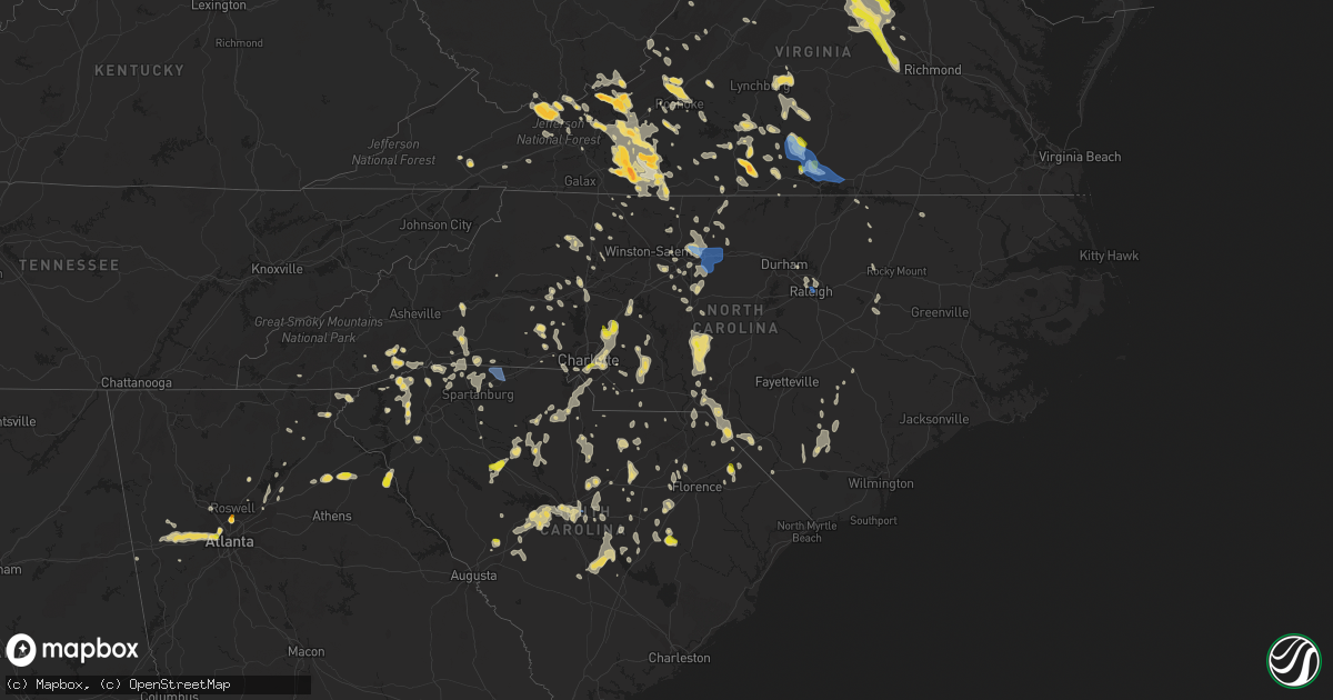
Hail Map in North Carolina on June 16, 2022
Get this storm
June 16 map
$229
one time, instant access
Download today. No call, no setup
Keep the $229
Bought the map and want the full workflow? Apply the entire $229 to a subscription within 7 days. None of it is wasted.
Every map, not just this one
This buys you this map. Subscription and you get every map we run, in the markets you choose from a few cities to whole states to nationwide. Plus real-time alerts the moment a storm fires.
Contact data
Name, contact info, occupancy, even credit band for addresses in the footprint. You go from where it hit to who to call.
Become the source they trust
Unlimited branding weather history reports on demand. You already have the documented answer ready for the property owner, and you are the one who showed up with it.
Property data and RoofTrace estimates
Pull up any address you have got, its value and the exact code rules for that jurisdiction, straight from One Click Code. Then RoofTrace estimates the squares, pitch, and roof value, priced the way you price.
Storm reports in North Carolina
North Carolina
| Date | Description |
|---|---|
| 06/16/20225:50 PM CDT | Numerous trees and power lines down throughout scotland county. |
| 06/16/20225:30 PM CDT | Numerous trees and power lines down throughout richmond county. |
| 06/16/20225:18 PM CDT | Tree down on nc highway 211 near the moore/montgomery county line. |
| 06/16/20225:14 PM CDT | Tree blocking road at cole rd and brewer rd. |
| 06/16/20225:11 PM CDT | Tree on road at w ewing st and w main st in candor. |
| 06/16/20225:08 PM CDT | Tree on road at ballpark rd and us highway 220 alt s. |
| 06/16/20225:08 PM CDT | Tree down blocking road at cabin creek rd and coy rd. |
| 06/16/20225:08 PM CDT | Tree and power pole down at cabin creek rd and post office rd. |
| 06/16/20225:05 PM CDT | Tree on road at sedberry rd and cedar creek rd. |
| 06/16/20225:05 PM CDT | Tree down at mccaskill rd. |
| 06/16/20225:05 PM CDT | Power pole on tree... Resulting in an electrical fire. |
| 06/16/20225:01 PM CDT | Several reports of trees down near the city of wadesboro. Time estimated by radar. |
| 06/16/20225:00 PM CDT | Power pole on tree... Resulting in an electrical fire. |
| 06/16/20225:00 PM CDT | Tree on road at sedberry rd and cedar creek rd. |
| 06/16/20224:52 PM CDT | Tree down at cross link rd and hadley rd. |
| 06/16/20224:52 PM CDT | Tree down at the 700 block of belmont dr in raleigh. |
| 06/16/20224:52 PM CDT | Tree down at s state st and i-40. |
| 06/16/20224:50 PM CDT | Power line down at the 2000 block of poole rd. |
| 06/16/20224:48 PM CDT | Tree down at lake wheeler rd and s saunders st in raleigh. |
| 06/16/20224:48 PM CDT | Tree down at the 1000 block of s person st in downtown raleigh. |
| 06/16/20224:48 PM CDT | Tree down at renfrow rd and parkland rd. |
| 06/16/20224:29 PM CDT | Report of a tree down in the city of ansonville blocking the roadway. Time estimated by radar. |
| 06/16/20224:28 PM CDT | Trees down county wide. |
| 06/16/20224:25 PM CDT | Tree down at spence farm rd and olde mckenzie dr in holly springs. |
| 06/16/20224:21 PM CDT | Several report349) 0000 w 7 wnw holly hill orangeburg sc 3336 8053 sc highway patrol reported trees down on i95 at mile marker 88sb. Time estimat |
| 06/16/20224:21 PM CDT | Several reports of downed trees around the city of polkton. Time estimated by radar. |
| 06/16/20224:13 PM CDT | Several reports of trees down around the city of peachland. Time estimated by radar. |
| 06/16/20224:12 PM CDT | Trees down county wide. |
| 06/16/20224:03 PM CDT | Tree across lincoln street in cramerton. |
| 06/16/20223:59 PM CDT | A tree fell on montgomery nc 3531 7976 tree on road at ballpark rd and us highway 220 alt s. |
| 06/16/20223:59 PM CDT | A tree fell on a car |
| 06/16/20223:53 PM CDT | Corrects previous tstm wnd dmg report from 1 se oakboro. Several trees down in the area of oakboro. Time estimated by radar. |
| 06/16/20223:53 PM CDT | Fallen trees caused power outages in downtown pittsboro as well as to the north and west. |
| 06/16/20223:49 PM CDT | Tree down on cedar forest rd. |
| 06/16/20223:45 PM CDT | Quarter size hail in cotswold area. |
| 06/16/20223:41 PM CDT | Multiple trees down on the southside of yadkinville nc. |
| 06/16/20223:37 PM CDT | Tree down on fishing creek rd. |
| 06/16/20223:37 PM CDT | Tree down near intersection of fishing creek rd and lw anderson rd. |
| 06/16/20223:36 PM CDT | Fallen trees causing power outages on randolph church rd and holder farm rd. |
| 06/16/20223:30 PM CDT | Fallen trees causing power outages on piney grove church rd. |
| 06/16/20223:30 PM CDT | Tree down on old 60 hwy near ronda nc. |
| 06/16/20223:14 PM CDT | Large tree down on house along hwy 16 south of newton. |
| 06/16/20223:04 PM CDT | Fallen trees caused power outages at robertson rd and rolling creek dr. |
| 06/16/20223:04 PM CDT | Fallen trees caused power outages at robertson rd and rolling creek dr. A car in the jordan lake area. |
| 06/16/20223:01 PM CDT | Emergency management confirmed trees and powerlines down county-wide. Some areas include mcleansville... Greensboro... Pleasant garden... And forest oaks. |
| 06/16/20222:55 PM CDT | Fallen trees causing power outages in downtown greensboro. |
| 06/16/20222:54 PM CDT | Tree down on nc hwy 86 near the caswell farmers market. |
| 06/16/20222:49 PM CDT | A local report indicates 1.00 inch wind near 1 SE KANNAPOLIS |
| 06/16/20222:48 PM CDT | Trees down. |
| 06/16/20222:44 PM CDT | Trees and power lines down. Widespread tree damage across southern rowan... Northern cabarrus... And central cabarrus counties. |
| 06/16/20222:43 PM CDT | One tree down due to thunderstorm winds near the intersection of spearmen road and cunningham mill road. |
| 06/16/20222:42 PM CDT | Multiple trees down reported throughout providence... Nc. |
| 06/16/20222:40 PM CDT | One tree down due to thunderstorm winds along church street extension. |
| 06/16/20222:40 PM CDT | One tree down due to thunderstorm winds along meadow branch road. |
| 06/16/20222:39 PM CDT | Multiple trees down due to thunderstorm winds along sandy cross road. |
| 06/16/20222:38 PM CDT | One tree down due to thunderstorm winds along the 100 block of woolen store road. |
| 06/16/20222:35 PM CDT | One tree down due to thunderstorm winds along wendy oak road. |
| 06/16/20222:34 PM CDT | Quarter sized hail near the intersection of nc hwy 268 and route 601. |
| 06/16/20222:30 PM CDT | Numerous reports of trees and power lines down throughout the county. Reports still coming in as of 4:15 pm. |
| 06/16/20222:28 PM CDT | One tree down due to thunderstorm winds at the intersection of new lebanon church road and nc highway 65. |
| 06/16/20222:26 PM CDT | One tree down due to thunderstorm winds along mccollum road. |
| 06/16/20222:20 PM CDT | Trees down in spencer and in east spencer. |
| 06/16/20222:19 PM CDT | A tree down blocking the road near the intersection of windswept drive and crossing ridge drive. Time estimated by radar. |
| 06/16/20222:14 PM CDT | One tree down due to thunderstorm winds along cheney loop road. |
| 06/16/20222:09 PM CDT | Partially rotten large oak tree blown down. |
| 06/16/20222:09 PM CDT | One tree down due to the thunderstorm winds along the 1700 block of ayersville road. |
| 06/16/20221:49 PM CDT | Tree down on nc hwy 770. Time estimated from radar. |
| 06/16/20221:47 PM CDT | Trees down from millspring to rutherford county line. |
| 06/16/20221:42 PM CDT | Multiple trees down in statesville... From photographs sent to office. |
| 06/16/20221:34 PM CDT | Tree down on king road. |
| 06/16/20221:30 PM CDT | Thunderstorm winds blew down a tree which took down powerlines on rockford road. |
| 06/16/20221:30 PM CDT | Tree down on hwy 704. Time estimated from radar. |
| 06/16/20221:26 PM CDT | 5 trees down. |
| 06/16/20221:26 PM CDT | 2 trees down. Time estimated from radar. |
| 06/16/202212:38 PM CDT | Trees down in pleasant gardens area. |
| 06/16/202212:38 PM CDT | Pleasant gardens area. |
| 06/16/202212:18 PM CDT | Reported on nix creek rd. In sugar hill area. |
| 06/16/20227:46 AM CDT | At 1246 PM EDT, a severe thunderstorm was located 8 miles north of Brevard, or 5 miles northwest of Etowah, and is nearly stationary. HAZARD...60 mph wind gusts and quarter size hail. SOURCE...Radar indicated. IMPACT...Minor hail damage to vehicles is expected. Expect wind damage to trees and power lines. Locations impacted include... Mills River, Etowah, Forge Mountain, Horse Shoe, North Transylvania, Penrose and Looking Glass. |
| 06/16/20227:46 AM CDT | At 1246 PM EDT, a severe thunderstorm was located near Fremont, or 17 miles north of Goldsboro, moving southeast at 15 mph. HAZARD...60 mph wind gusts and quarter size hail. SOURCE...Radar indicated. IMPACT...Hail damage to vehicles is expected. Expect wind damage to roofs, siding, and trees. Locations impacted include... Wilson, Fremont, Lucama, Stantonsburg, Black Creek, Pikeville, Saratoga, Eureka and Nahunta. |
| 06/16/20222:32 AM CDT | At 732 PM EDT, severe thunderstorms were located along a line extending from Fairmont to near Floydale, moving southeast at 15 mph. HAZARD...60 mph wind gusts and quarter size hail. SOURCE...Radar indicated. IMPACT...Minor hail damage to vehicles is possible. Expect wind damage to trees and power lines. Locations impacted include... Dillon, Pembroke, Fairmont, Latta, Rowland, Lake View, Clio, Sellers, Fork, Zion, Hamer, South Of The Border, Minturn, Elrod, Raemon, Barnesville, Floydale, Smithboro, Kemper and Purvis. |
| 06/16/20221:43 AM CDT | At 641 PM EDT, a severe thunderstorm was located near Hoffman, or 12 miles north of Laurinburg, moving south at 20 mph. HAZARD...60 mph wind gusts and nickel size hail. SOURCE...Radar indicated. IMPACT...Expect damage to roofs, siding, and trees. Locations impacted include... Laurinburg, Aberdeen, Maxton, Hoffman, Pinebluff, Wagram, East Laurinburg, Laurel Hill, Bowmore and Camp Mackall. |
| 06/16/20221:03 AM CDT | At 603 PM EDT, a severe thunderstorm was located over Biscoe, or near Troy, moving south at 15 mph. HAZARD...60 mph wind gusts and quarter size hail. SOURCE...Radar indicated. IMPACT...Hail damage to vehicles is expected. Expect wind damage to roofs, siding, and trees. Locations impacted include... Troy, Biscoe, Foxfire, Star, Candor, Norman, Seven Lakes and Eagle Springs. |
| 06/16/202212:44 AM CDT | At 544 PM EDT, a severe thunderstorm was located near Raleigh, moving southeast at 25 mph. HAZARD...60 mph wind gusts and penny size hail. SOURCE...Radar indicated. IMPACT...Expect damage to roofs, siding, and trees. Locations impacted include... Raleigh, Cary, Garner, Clayton, RDU International, Knightdale, Wendell, William B Umstead State Park, Flowers and Lake Benson. |
| 06/16/202212:39 AM CDT | At 539 PM EDT, a severe thunderstorm was located near Biscoe, or 12 miles east of Troy, and is nearly stationary. HAZARD...60 mph wind gusts and quarter size hail. SOURCE...Radar indicated. IMPACT...Hail damage to vehicles is expected. Expect wind damage to roofs, siding, and trees. Locations impacted include... Biscoe, Robbins, Star, Candor, Steeds, Highfalls, Eagle Springs and Seven Lakes. |
| 06/16/202212:33 AM CDT | At 533 PM EDT, a severe thunderstorm was located near Windy Gap, or 8 miles south of Ronda, moving southeast at 25 mph. HAZARD...60 mph wind gusts and quarter size hail. SOURCE...Radar indicated. IMPACT...Hail damage to vehicles is expected. Expect wind damage to roofs, siding, and trees. Locations impacted include... Windy Gap... Buck Shoals... Lone Hickory... and Brooks Crossroads. |
| 06/16/202212:08 AM CDT | At 507 PM EDT, a severe thunderstorm was located 10 miles north of Marshville, or 16 miles northeast of Monroe, moving south at 15 mph. HAZARD...60 mph wind gusts and nickel size hail. SOURCE...Radar indicated. IMPACT...Expect damage to roofs, siding, and trees. Locations impacted include... Wadesboro, Ansonville, Polkton, Norwood, Peachland, White Store and Lake Tillery. |
| 06/15/202211:54 PM CDT | At 454 PM EDT, a severe thunderstorm was located 11 miles southwest of Yadkinville, or near Harmony, moving southeast at 25 mph. HAZARD...60 mph wind gusts and quarter size hail. SOURCE...Radar indicated. IMPACT...Minor hail damage to vehicles is expected. Expect wind damage to trees and power lines. Locations impacted include... Mocksville, Bermuda Run, Harmony, Love Valley, Turnersburg, Olin, Cool Springs, Sheffield, Union Grove and Farmington. |
| 06/15/202211:50 PM CDT | At 450 PM EDT, a severe thunderstorm was located near Gastonia, moving east at 15 mph. HAZARD...60 mph wind gusts and quarter size hail. SOURCE...Radar indicated. IMPACT...Minor hail damage to vehicles is expected. Expect wind damage to trees and power lines. Locations impacted include... Gastonia, Mt Holly, Belmont, South Gastonia, Dallas, Stanley, Cramerton, Lowell, Ranlo and Mcadenville. |
| 06/15/202211:46 PM CDT | At 446 PM EDT, severe thunderstorms were located along a line extending from near Drakes Branch to Redoak to near Virgilina, moving southeast at 30 mph. HAZARD...60 mph wind gusts and quarter size hail. SOURCE...Radar indicated. IMPACT...Minor damage to vehicles is possible. Expect wind damage to trees and powerlines. Severe thunderstorms will be near... Clarksville, Kells Corner and Rehoboth around 505 PM EDT. Chase City around 510 PM EDT. Boydton around 515 PM EDT.Other locations impacted by these severe thunderstorms includeNelson, Wilburn, Spanish Grove, Beechwood, John H Kerr Dam, NorthView, Finchley, Finneywood, Skipwith and Fairview. |
| 06/15/202211:43 PM CDT | At 441 PM EDT, severe thunderstorms were located along a line extending from near Hillsborough to near Siler City to Asheboro, moving southeast at 25 mph. HAZARD...60 mph wind gusts and nickel size hail. SOURCE...Radar indicated. IMPACT...Expect damage to roofs, siding, and trees. Locations impacted include... Raleigh, Durham, Cary, Chapel Hill, Asheboro, Hillsborough, Randleman, Pittsboro, Siler City and North Carolina Zoo. |
| 06/15/202211:37 PM CDT | At 436 PM EDT, a severe thunderstorm was located over Wylliesburg, or near Redoak, moving east at 35 mph. HAZARD...60 mph wind gusts and quarter size hail. SOURCE...Radar indicated. IMPACT...Hail damage to vehicles is expected. Expect wind damage to roofs, siding, and trees. Locations impacted include... South Boston... Keysville... Charlotte Court House... Phenix... Virgilina... Redoak... and Red House. |
| 06/15/202211:27 PM CDT | At 425 PM EDT, a severe thunderstorm was located near Plyler, or near Albemarle, and is nearly stationary. A second severe thunderstorm was located northeast of Locust. HAZARD...60 mph wind gusts and nickel size hail. SOURCE...Radar indicated. IMPACT...Expect damage to roofs, siding, and trees. Locations impacted include... Albemarle, Plyler, Locust, Oakboro, Stanfield, Richfield, New London and Finger. |
| 06/15/202211:26 PM CDT | At 426 PM EDT, a severe thunderstorm was located near Swancreek, or near Ronda, moving southeast at 15 mph. HAZARD...60 mph wind gusts and quarter size hail. SOURCE...Radar indicated. IMPACT...Hail damage to vehicles is expected. Expect wind damage to roofs, siding, and trees. Locations impacted include... North Wilkesboro... Wilkesboro... Yadkinville... Jonesville... Ronda... Boomer... and Windy Gap. |
| 06/15/202211:21 PM CDT | At 421 PM EDT, a severe thunderstorm was located 9 miles west of Lincolnton, or 4 miles north of Cherryville, moving east at 15 mph. HAZARD...60 mph wind gusts and quarter size hail. SOURCE...Radar indicated. IMPACT...Minor hail damage to vehicles is expected. Expect wind damage to trees and power lines. Locations impacted include... Lincolnton, Cherryville, High Shoals, Waco, Boger City, Iron Station, Crouse, Fallston, Stanley and Belwood. |
| 06/15/202211:18 PM CDT | At 417 PM EDT, severe thunderstorms were located along a line extending from near Baynes to 9 miles south of McLeansville to near High Point, moving southeast at 20 mph. HAZARD...70 mph wind gusts and nickel size hail. SOURCE...Radar indicated. IMPACT...Expect considerable tree damage. Damage is likely to mobile homes, roofs, and outbuildings. Locations impacted include... High Point, Burlington, Asheboro, Graham, Randleman, Siler City, Mebane, Elon, Archdale and Trinity. |
| 06/15/202211:03 PM CDT | At 403 PM EDT, a severe thunderstorm was located over Hightowers, or near Jericho, moving southeast at 35 mph. HAZARD...60 mph wind gusts and quarter size hail. SOURCE...Radar indicated. IMPACT...Hail damage to vehicles is expected. Expect wind damage to roofs, siding, and trees. Locations impacted include... Reidsville... Yanceyville... Jericho... Prospect Hill... Camp Springs... Milton... and Quick. |
| 06/15/202210:55 PM CDT | At 354 PM EDT, severe thunderstorms were located along a line extending from near Elmo to near Camp Springs, moving southeast at 30 mph. HAZARD...60 mph wind gusts and penny size hail. SOURCE...Radar indicated. IMPACT...Expect damage to roofs, siding, and trees. Locations impacted include... Roxboro, Hillsborough, Mebane, Rougemont, Concord, Carr, Efland, Mayo Reservoir, Schley and Bethel Hill. |
| 06/15/202210:55 PM CDT | At 355 PM EDT, severe thunderstorms were located along a line extending from 8 miles north of Gaffney to 11 miles southeast of Spartanburg, moving southeast at 20 mph. HAZARD...60 mph wind gusts and nickel size hail. SOURCE...Radar indicated. IMPACT...Expect damage to trees and power lines. Locations impacted include... Gaffney, Union, Pacolet, Monarch Mill, Blacksburg, Buffalo, Jonesville, Pacolet Mills, Grover and Patterson Springs. |
| 06/15/202210:54 PM CDT | At 354 PM EDT, a severe thunderstorm was located 5 miles west of Downtown Concord, or near West Concord, moving southeast at 5 mph. HAZARD...60 mph wind gusts and quarter size hail. SOURCE...Radar indicated. IMPACT...Minor hail damage to vehicles is expected. Expect wind damage to trees and power lines. Locations impacted include... Downtown Concord, Northeast Charlotte, West Concord, Harrisburg, University City, Reedy Creek Park, Coddle Creek Reservoir, Charlotte Motor Speedway, Croft and Mint Hill. |
| 06/15/202210:45 PM CDT | At 344 PM EDT, a severe thunderstorm was located near Hickory, moving southeast at 15 mph. HAZARD...60 mph wind gusts and quarter size hail. SOURCE...Radar indicated. IMPACT...Minor hail damage to vehicles is expected. Expect wind damage to trees and power lines. Locations impacted include... Hickory, Statesville, St. Stephens, Conover, Claremont, Catawba, Lookout Shoals Lake, Bandys, Millersville and Scotts. |
| 06/15/202210:40 PM CDT | At 340 PM EDT, severe thunderstorms were located along a line extending from Yanceyville to near High Point, moving southeast at 20 mph. HAZARD...60 mph wind gusts and nickel size hail. SOURCE...Radar indicated. IMPACT...Expect damage to roofs, siding, and trees. Locations impacted include... Greensboro, High Point, Burlington, Graham, Mebane, Elon, McLeansville, Gibsonville, Pleasant Garden and Jamestown. |
| 06/15/202210:34 PM CDT | At 334 PM EDT, a severe thunderstorm was located over Crutchfield, or over Fairview, moving east at 20 mph. HAZARD...60 mph wind gusts and quarter size hail. SOURCE...Radar indicated. IMPACT...Hail damage to vehicles is expected. Expect wind damage to roofs, siding, and trees. Locations impacted include... Elkin... Fairview... Jonesville... Dobson... Pilot Mountain... Boonville... and East Bend. |
| 06/15/202210:32 PM CDT | At 332 PM EDT, a severe thunderstorm was located 5 miles southwest of Hickory, or near Mountain View, moving southeast at 20 mph. HAZARD...60 mph wind gusts and quarter size hail. SOURCE...Radar indicated. IMPACT...Minor hail damage to vehicles is expected. Expect wind damage to trees and power lines. Locations impacted include... Newton, Lincolnton, Maiden, Mountain View, Startown, Propst, Vale, Longview, Cooksville and Hickory. |
| 06/15/202210:27 PM CDT | At 327 PM EDT, a severe thunderstorm was located near Kannapolis, moving southeast at 5 mph. HAZARD...60 mph wind gusts and quarter size hail. SOURCE...Radar indicated. IMPACT...Minor hail damage to vehicles is expected. Expect wind damage to trees and power lines. Locations impacted include... Kannapolis, Downtown Concord, China Grove, Landis, Enochville, Mt Pleasant, West Concord and Coddle Creek Reservoir. |
| 06/15/202210:22 PM CDT | At 322 PM EDT, a severe thunderstorm was located 8 miles southeast of Lincolnton, or near Stanley, moving southeast at 15 mph. HAZARD...60 mph wind gusts and quarter size hail. SOURCE...Radar indicated. IMPACT...Minor hail damage to vehicles is expected. Expect wind damage to trees and power lines. Locations impacted include... Gastonia, Huntersville, Mt Holly, Belmont, Dallas, Stanley, Cramerton, Lowell, Ranlo and High Shoals. |
| 06/15/202210:21 PM CDT | At 321 PM EDT, a severe thunderstorm was located near Pine Hall, or near Walnut Cove, moving east at 10 mph. HAZARD...60 mph wind gusts and quarter size hail. SOURCE...Radar indicated. IMPACT...Hail damage to vehicles is expected. Expect wind damage to roofs, siding, and trees. Locations impacted include... Greensboro, Summerfield, Stokesdale, Colfax, Belews Creek and Belews Lake. |
| 06/15/202210:14 PM CDT | At 314 PM EDT, a severe thunderstorm was located 5 miles east of Salisbury, or near Spencer, and is nearly stationary. HAZARD...60 mph wind gusts and quarter size hail. SOURCE...Radar indicated. IMPACT...Minor hail damage to vehicles is expected. Expect wind damage to trees and power lines. Locations impacted include... Salisbury, Spencer, Granite Quarry, Rockwell, Faith, High Rock Lake, Gold Hill and High Rock. |
| 06/15/202210:13 PM CDT | At 313 PM EDT, severe thunderstorms were located along a line extending from 4 miles south of Rutherfordton to 13 miles west of Spartanburg, moving east at 20 mph. HAZARD...60 mph wind gusts and quarter size hail. SOURCE...Radar indicated. IMPACT...Minor hail damage to vehicles is expected. Expect wind damage to trees and power lines. Locations impacted include... Spartanburg, Forest City, Rutherfordton, Columbus, Boiling Springs SC, Spindale, Duncan, Lyman, Landrum and Cowpens. |
| 06/15/202210:00 PM CDT | At 300 PM EDT, a severe thunderstorm was located over Westover Hills, or near Danville, moving southeast at 65 mph. HAZARD...60 mph wind gusts and quarter size hail. SOURCE...Radar indicated. IMPACT...Hail damage to vehicles is expected. Expect wind damage to roofs, siding, and trees. Locations impacted include... Danville... Eden... Reidsville... Martinsville... Yanceyville... Bethel... and Chatham.This includes The following Location Danville Airport. |
| 06/15/20229:59 PM CDT | At 259 PM EDT, severe thunderstorms were located along a line extending from near Abbottsburg to near Rowan, moving south at 25 mph. HAZARD...Quarter size hail. SOURCE...Radar indicated. IMPACT...Minor damage to vehicles is possible. Locations impacted include... Whiteville, Elizabethtown, Rowan, Bladenboro, Lake Waccamaw, Sandyfield, Hallsboro, Redbug, Council, Riegelwood, Carvers, Abbottsburg, Lisbon, Lagoon, Elkton, Emerson, Kelly, Freeman, Delco and Brunswick. |
| 06/15/20229:45 PM CDT | At 244 PM EDT, a severe thunderstorm was located 7 miles southwest of Rutherfordton, moving south at 20 mph. HAZARD...60 mph wind gusts and half dollar size hail. SOURCE...Radar indicated. IMPACT...Minor hail damage to vehicles is expected. Expect wind damage to trees and power lines. The strongest winds moving ahead of the rain, so do not wait for the rain to begin to take shelter. Locations impacted include... Rutherfordton, Columbus, Tryon, Green Hill, Mill Spring, Green Creek, Lake Adger, Spindale and Lake Lure. |
| 06/15/20229:35 PM CDT | At 235 PM EDT, severe thunderstorms were located along a line extending from near Elizabethtown to near Harrells, moving south at 15 mph. HAZARD...Quarter size hail. SOURCE...Radar indicated. IMPACT...Minor damage to vehicles is possible. Locations impacted include... Elizabethtown, Lagoon, Lisbon, White Lake and Bladen County Hospital. |
| 06/15/20229:32 PM CDT | At 232 PM EDT, a severe thunderstorm was located near Statesville, moving southeast at 15 mph. HAZARD...60 mph wind gusts and quarter size hail. SOURCE...Radar indicated. IMPACT...Minor hail damage to vehicles is expected. Expect wind damage to trees and power lines. Locations impacted include... Statesville, Troutman, Stony Point, Hiddenite, Turnersburg, Olin, Scotts, Cool Springs, Cleveland and Cooleemee. |
| 06/15/20229:30 PM CDT | At 229 PM EDT, severe thunderstorms were located along a line extending from near Brevard to 20 miles southeast of Sylva, and are nearly stationary. Another storm was located along the Haywood Transylvania County border, drifting southeast near 5 mph. HAZARD...60 mph wind gusts and quarter size hail. SOURCE...Radar indicated. IMPACT...Minor hail damage to vehicles is expected. Expect wind damage to trees and power lines. Locations impacted include... Brevard, Rosman, Lake Toxaway, Graveyard Fields, Looking Glass, B.R. Parkway-Black Balsam To Mount Pisgah, Mount Pisgah, B.R. Parkway-Balsam Gap To Black Balsam Area, Black Balsam Area and Balsam Grove. |
| 06/15/20229:28 PM CDT | At 228 PM EDT, a severe thunderstorm was located near Lincolnton, moving southeast at 20 mph. HAZARD...60 mph wind gusts and quarter size hail. SOURCE...Radar indicated. IMPACT...Minor hail damage to vehicles is expected. Expect wind damage to trees and power lines. Locations impacted include... Lincolnton, Maiden, Westport, High Shoals, Boger City, Iron Station, Denver, Crouse, Dallas and Cherryville. |
| 06/15/20229:18 PM CDT | At 218 PM EDT, a severe thunderstorm was located over Callands, moving southeast at 40 mph. HAZARD...60 mph wind gusts and quarter size hail. SOURCE...Radar indicated. IMPACT...Hail damage to vehicles is expected. Expect wind damage to roofs, siding, and trees. Locations impacted include... Danville... Chatham... Blairs... Callands... Axton... Snow Creek... and Leatherwood.This includes The following Location Danville Airport. |
| 06/15/20229:06 PM CDT | At 206 PM EDT, a severe thunderstorm was located 10 miles northwest of Rutherfordton, or 7 miles east of Lake Lure, moving south at 5 mph. HAZARD...60 mph wind gusts and quarter size hail. SOURCE...Radar indicated. IMPACT...Minor hail damage to vehicles is expected. Expect wind damage to trees and power lines. Locations impacted include... Rutherfordton, Lake Lure, Shingle Hollow, Green Hill, Thermal City, Lake Adger, Union Mills, Mill Spring and Chimney Rock State Park. |
| 06/15/20229:01 PM CDT | At 200 PM EDT, severe thunderstorms were located along a line extending from near Bowdens to near Ammon, moving southeast at 20 mph. HAZARD...60 mph wind gusts and quarter size hail. SOURCE...Radar indicated. IMPACT...Hail damage to vehicles is expected. Expect wind damage to roofs, siding, and trees. Locations impacted include... Clinton, Harrells, Garland and Turkey. |
| 06/15/20228:43 PM CDT | At 143 PM EDT, a severe thunderstorm was located over Fairy Stone State Park, or near Bassett, moving southeast at 10 mph. HAZARD...60 mph wind gusts and quarter size hail. SOURCE...Radar indicated. IMPACT...Hail damage to vehicles is expected. Expect wind damage to roofs, siding, and trees. Locations impacted include... Martinsville... Bassett... Ridgeway... Villa Heights... Chatmoss... Collinsville... and Horse Pasture.This includes The following Locations The Martinsville Speedway andMartinsville Airport. |
| 06/15/20228:25 PM CDT | At 125 PM EDT, a severe thunderstorm was located near Brevard, and is nearly stationary. HAZARD...60 mph wind gusts and quarter size hail. SOURCE...Radar indicated. IMPACT...Minor hail damage to vehicles is expected. Expect wind damage to trees and power lines. Locations impacted include... Brevard, Jones Gap State Park, Dupont State Forest, Table Rock State Park, Caesars Head State Park, Pumpkintown, Penrose, Connestee, Crab Creek and Cleveland. |
| 06/15/20228:24 PM CDT | At 124 PM EDT, a severe thunderstorm was located near Critz, or 7 miles northeast of Stuart, moving southeast at 10 mph. HAZARD...60 mph wind gusts and quarter size hail. SOURCE...Radar indicated. IMPACT...Hail damage to vehicles is expected. Expect wind damage to roofs, siding, and trees. Locations impacted include... Stuart... Spencer... Sanville... Penns Store... Critz... Patrick Springs... and Horse Pasture. |
| 06/15/20228:12 PM CDT | At 111 PM EDT, a severe thunderstorm was located near Marion, moving southeast at 15 mph. HAZARD...60 mph wind gusts and quarter size hail. SOURCE...Radar indicated. IMPACT...Minor hail damage to vehicles is expected. Expect wind damage to trees and power lines. Locations impacted include... Marion, Old Fort, Lake James State Park, Lake James, Nebo, Sugar Hill, Pleasant Gardens, Glenwood, Fero and Dysartsville. |
All States Impacted by Hail Map on June 16, 2022
Cities Impacted by Hail Map on June 16, 2022
- Fort Covington, NY
- Brushton, NY
- Oswego, NY
- Hannibal, NY
- Fine, NY
- Fulton, NY
- Clay, NY
- Brewerton, NY
- Trenton, MO
- Spickard, MO
- North Bend, PA
- Lock Haven, PA
- Chaumont, NY
- Bellwood, NE
- David City, NE
- Bethany, MO
- Ridgeway, MO
- Martinsville, MO
- Ransomville, NY
- Wilson, NY
- Canandaigua, NY
- Stanley, NY
- Bloomfield, IA
- Moulton, IA
- Verdon, NE
- Salem, NE
- Humboldt, NE
- Falls City, NE
- Dawson, NE
- Lacona, NY
- Sandy Creek, NY
- Pulaski, NY
- Chaffee, NY
- West Valley, NY
- East Concord, NY
- Bliss, NY
- Sardinia, NY
- Springville, NY
- Arcade, NY
- Delevan, NY
- Yorkshire, NY
- Saegertown, PA
- Cambridge Springs, PA
- Hastings, IA
- Johnstown, OH
- Massena, NY
- Gouverneur, NY
- Theresa, NY
- Antwerp, NY
- Fort Drum, NY
- Philadelphia, NY
- Watertown, NY
- Rodman, NY
- La Fargeville, NY
- Abie, NE
- Bruno, NE
- Linwood, NE
- Honeoye Falls, NY
- Victor, NY
- Frederick, IL
- Mount Sterling, IL
- Rushville, IL
- Browning, IL
- Timewell, IL
- Elkhart, IL
- Garden Grove, IA
- Allerton, IA
- Princeton, MO
- Waterford, PA
- Edinboro, PA
- Wattsburg, PA
- Conneaut, OH
- McKean, PA
- Albion, PA
- Girard, PA
- Cranesville, PA
- Union City, PA
- Kingsville, OH
- Erie, PA
- Springboro, PA
- Shortsville, NY
- Palmyra, NY
- Farmington, NY
- Wolbach, NE
- Corning, IA
- Hermon, NY
- Eagleville, MO
- Hatfield, MO
- Cape Vincent, NY
- Clayton, NY
- Pennellville, NY
- Memphis, NY
- Clyde, NY
- Central Square, NY
- Cato, NY
- Jordan, NY
- Red Creek, NY
- Martville, NY
- Savannah, NY
- Wolcott, NY
- Sterling, NY
- Phoenix, NY
- Weedsport, NY
- Port Byron, NY
- Lyons, NY
- Sodus, NY
- North Rose, NY
- Baldwinsville, NY
- Brewster, OH
- Navarre, OH
- Geneseo, NY
- Clifton Springs, NY
- Leicester, NY
- Manchester, NY
- Phelps, NY
- Conesus, NY
- Bloomfield, NY
- Honeoye, NY
- Silver Springs, NY
- Gainesville, NY
- Silver Lake, NY
- Mount Morris, NY
- Perry, NY
- Hemlock, NY
- Castile, NY
- Lima, NY
- Livonia, NY
- Hammond, NY
- De Peyster, NY
- Cattaraugus, NY
- East Otto, NY
- Snow Shoe, PA
- Moshannon, PA
- Drakesville, IA
- Syracuse, NY
- Liverpool, NY
- Conneautville, PA
- Greenville, PA
- Kinsman, OH
- Fowler, OH
- Burghill, OH
- Farmdale, OH
- Howard, OH
- Gambier, OH
- Gilman City, MO
- Kellerton, IA
- Lamoni, IA
- Landisburg, PA
- Sherman, NY
- Findley Lake, NY
- Clymer, NY
- Newark, NY
- Jamesville, NY
- Auburn, NY
- Copenhagen, NY
- Clarence, PA
- Pottersdale, PA
- James City, PA
- Weedville, PA
- Clarendon, PA
- Kersey, PA
- Bellefonte, PA
- Benezett, PA
- Tidioute, PA
- Centerville, PA
- Spartansburg, PA
- Driftwood, PA
- Grand Valley, PA
- Titusville, PA
- Sheffield, PA
- Saint Marys, PA
- Howard, PA
- Pittsfield, PA
- Ridgway, PA
- Johnsonburg, PA
- Sinnamahoning, PA
- Marienville, PA
- Kane, PA
- Tionesta, PA
- Karthaus, PA
- Kersey, CO
- Greeley, CO
- La Salle, CO
- Geneva, NY
- Fremont, IN
- Angola, IN
- Edon, OH
- Warren, OH
- Vienna, OH
- Emlenton, PA
- Masury, OH
- Jackson Center, PA
- Transfer, PA
- Petrolia, PA
- Stoneboro, PA
- Parker, PA
- Mercer, PA
- Eau Claire, PA
- Harrisville, PA
- Rimersburg, PA
- Hermitage, PA
- Fredonia, PA
- Fairmount City, PA
- Clintonville, PA
- Cortland, OH
- Hilliards, PA
- Clark, PA
- West Sunbury, PA
- Karns City, PA
- New Bethlehem, PA
- Boyers, PA
- Grove City, PA
- Sligo, PA
- Sharpsville, PA
- Polk, PA
- Bruin, PA
- Kennerdell, PA
- North Bloomfield, OH
- Chardon, OH
- Huntsburg, OH
- Middlefield, OH
- Novelty, OH
- Chesterland, OH
- Orwell, OH
- Newbury, OH
- Burton, OH
- Windsor, OH
- Gates Mills, OH
- Russell, NY
- Medina, NY
- Middleport, NY
- Richville, NY
- De Kalb Junction, NY
- Redwood, NY
- Grand River, IA
- Albany, MO
- New Hampton, MO
- McFall, MO
- Tingley, IA
- Ellston, IA
- Browning, MO
- Laredo, MO
- Chula, MO
- Humphreys, MO
- Franklin, PA
- Cooperstown, PA
- Eagle Rock, VA
- Clifton Forge, VA
- Mulberry Grove, IL
- Bingham, IL
- Ramsey, IL
- Fillmore, IL
- Coffeen, IL
- Galt, MO
- Renovo, PA
- Statesville, NC
- Glenwood, IA
- Malvern, IA
- Pacific Junction, IA
- Tecumseh, NE
- Rockport, IL
- Pittsfield, IL
- Pleasant Hill, IL
- Benton, IA
- Clearfield, IA
- Bedford, IA
- Blockton, IA
- Rutherfordton, NC
- Chesnee, SC
- Clarence, MO
- Lentner, MO
- Powersville, MO
- Seymour, IA
- Lucerne, MO
- Newtown, MO
- Lineville, IA
- Pollock, MO
- Harris, MO
- Mercer, MO
- Unionville, MO
- Milan, MO
- Corydon, IA
- Clinton, NC
- Richwoods, MO
- Lonedell, MO
- Sullivan, MO
- Hoxie, KS
- Bland, VA
- Alpharetta, GA
- Morrisonville, IL
- Nokomis, IL
- Clover, SC
- Belmont, NC
- Gastonia, NC
- Darlington, SC
- Long Island, VA
- Greencastle, PA
- Clear Spring, MD
- Hagerstown, MD
- Mercersburg, PA
- Pisgah Forest, NC
- High Point, NC
- Jamestown, NC
- Ashland, IL
- Liberty, IL
- Mendenhall, MS
- Salem, WV
- Vesuvius, VA
- Lincolnton, NC
- Maybeury, WV
- Pocahontas, VA
- Bluefield, VA
- Welch, WV
- Bramwell, WV
- Luray, MO
- Queen City, MO
- Gibbs, MO
- Kirksville, MO
- Shelbyville, MO
- Brashear, MO
- Milton, IA
- La Plata, MO
- Cantril, IA
- Baring, MO
- Memphis, MO
- Atlanta, MO
- Hurdland, MO
- Bethel, MO
- Knox City, MO
- Rutledge, MO
- Novinger, MO
- Greentop, MO
- Farmington, IA
- Keosauqua, IA
- Mount Sterling, IA
- Bonaparte, IA
- Novelty, MO
- Kahoka, MO
- Pulaski, IA
- Downing, MO
- Edina, MO
- Arbela, MO
- La Belle, MO
- Lancaster, MO
- Newark, MO
- Green Castle, MO
- Leonard, MO
- Roanoke, VA
- Salem, VA
- Mifflin, PA
- McAlisterville, PA
- McClure, PA
- Millerstown, PA
- Mifflintown, PA
- Shermans Dale, PA
- Port Royal, PA
- Newport, PA
- Oakland Mills, PA
- New Bloomfield, PA
- Duncannon, PA
- Lewistown, PA
- Thompsontown, PA
- Marianna, FL
- Grand Ridge, FL
- Oconee, IL
- Pana, IL
- Six Mile, SC
- Central, SC
- Aldie, VA
- Leesburg, VA
- Gretna, VA
- Chatham, VA
- Java, VA
- West Union, WV
- Bluford, IL
- Dix, IL
- Irvington, IL
- Centralia, IL
- Johnsonville, IL
- Keenes, IL
- Walnut Hill, IL
- Texico, IL
- Kell, IL
- Mount Vernon, IL
- Iuka, IL
- Pelham, NC
- Ruffin, NC
- Reidsville, NC
- Tarkio, MO
- Watson, MO
- Rock Port, MO
- Westboro, MO
- Winston, GA
- Whitesburg, GA
- Clio, SC
- Blenheim, SC
- Bennettsville, SC
- Bentonia, MS
- Benton, MS
- Rapidan, VA
- Reva, VA
- Boston, VA
- Culpeper, VA
- Mitchells, VA
- West, MS
- Sallis, MS
- Elba, AL
- Kinston, AL
- Samson, AL
- Quincy, FL
- Montpelier, VA
- Rockville, VA
- Northport, AL
- Purcellville, VA
- Scarbro, WV
- Mount Hope, WV
- Fayetteville, WV
- Kincaid, WV
- Maidens, VA
- Powhatan, VA
- Palmyra, VA
- Goochland, VA
- Crozier, VA
- Pratts, VA
- Louisa, VA
- Madison, VA
- Columbia, VA
- Barboursville, VA
- Sandy Hook, VA
- Keswick, VA
- Somerset, VA
- Rochelle, VA
- Aroda, VA
- Unionville, VA
- Troy, VA
- Gum Spring, VA
- Radiant, VA
- Ruckersville, VA
- Gordonsville, VA
- Mineral, VA
- Kents Store, VA
- Stanardsville, VA
- State Farm, VA
- Orange, VA
- Bumpass, VA
- Tiger, GA
- Lakemont, GA
- Hardy, VA
- Bessemer City, NC
- Fort Lupton, CO
- Hudson, CO
- Sylacauga, AL
- Talladega, AL
- Goodwater, AL
- Stockport, OH
- Waterford, OH
- Newport, VA
- Union Mills, NC
- Lake Lure, NC
- Tryon, NC
- Mill Spring, NC
- Thomasville, NC
- Winston Salem, NC
- Northfork, WV
- Kimball, WV
- Brookneal, VA
- Nathalie, VA
- Gladys, VA
- Ellerbe, NC
- Emerson, IA
- Red Oak, IA
- Old Fort, NC
- Marion, NC
- Macon, NC
- Warrenton, NC
- Campobello, SC
- Greer, SC
- Landrum, SC
- McBee, SC
- Bethune, SC
- Jefferson, SC
- Dwight, NE
- Browns Summit, NC
- Nashville, NC
- Chattahoochee, FL
- Bainbridge, GA
- Sneads, FL
- Coatsburg, IL
- Camp Point, IL
- Paloma, IL
- Quincy, IL
- Clayton, IL
- Fowler, IL
- Quinton, AL
- Dora, AL
- Cordova, AL
- Marion, SC
- Norwood, LA
- Kershaw, SC
- Covington, VA
- Marble Hill, MO
- Vinton, LA
- Greensboro, NC
- Summerfield, NC
- McLeansville, NC
- Eastover, SC
- Dalzell, SC
- Rembert, SC
- Weeping Water, NE
- Carlisle, SC
- Whitmire, SC
- Newberry, SC
- Union, SC
- Tuskegee, AL
- Camillus, NY
- Warners, NY
- Joanna, SC
- Kinards, SC
- Silverstreet, SC
- Hopkins, SC
- Randolph, AL
- Jemison, AL
- Brierfield, AL
- Norfolk, NY
- Chase Mills, NY
- Friend, NE
- Cordova, NE
- York, NE
- Waco, NE
- McCool Junction, NE
- Exeter, NE
- Beaver Crossing, NE
- Glenmont, OH
- Danville, OH
- Lewistown, MO
- Chesterhill, OH
- Marine, IL
- Alhambra, IL
- Rushville, OH
- Somerset, OH
- Thornville, OH
- Penokee, KS
- Hill City, KS
- Morland, KS
- Baylis, IL
- Versailles, IL
- Griggsville, IL
- Chambersburg, IL
- Orrick, MO
- Lamar, CO
- Gainesville, VA
- Haymarket, VA
- Jonesville, NC
- Hamptonville, NC
- Lerona, WV
- Peterstown, WV
- Pipestem, WV
- Halifax, VA
- Crystal Hill, VA
- Wilson, NC
- Lucama, NC
- McConnells, SC
- Chester, SC
- Trinity, NC
- New Castle, VA
- Elizabethtown, NC
- Garland, NC
- Pinewood, SC
- Summerton, SC
- Bishopville, SC
- Camden, SC
- Cassatt, SC
- Saluda, SC
- Ward, SC
- Picayune, MS
- Troy, AL
- Louisville, AL
- Clayton, AL
- Perkinston, MS
- Smithdale, MS
- Liberty, MS
- Orangeburg, SC
- Cordova, SC
- Warsaw, IL
- Basco, IL
- Golden, IL
- West Point, IL
- Bowen, IL
- Lewisberry, PA
- Etters, PA
- New Cumberland, PA
- Bremen, OH
- Ronceverte, WV
- Sinks Grove, WV
- Alderson, WV
- Estes Park, CO
- Heath, OH
- Granville, OH
- Newark, OH
- Camp Hill, PA
- Summerdale, PA
- Enola, PA
- Marysville, PA
- Mechanicsburg, PA
- Elliottsburg, PA
- Harrisburg, PA
- York Haven, PA
- Lemoyne, PA
- Nashport, OH
- Butler, OH
- Wheeler, IL
- Loveland, CO
- Berthoud, CO
- Webster Springs, WV
- Eskdale, WV
- Gallagher, WV
- Montgomery, WV
- Martinsburg, WV
- Hedgesville, WV
- Hamilton, VA
- Clay City, IL
- Flora, IL
- Hillsboro, IL
- Donnellson, IL
- Philadelphia, MO
- Monroe City, MO
- Crawley, WV
- Smoot, WV
- Rainelle, WV
- Highland, IL
- Pocahontas, IL
- Greenville, IL
- Carlyle, IL
- Breese, IL
- White Sulphur Springs, WV
- Ballard, WV
- Union, WV
- Greenville, WV
- Ripplemead, VA
- Lindside, WV
- Pembroke, VA
- Narrows, VA
- Martinsville, VA
- Patrick Springs, VA
- Bassett, VA
- Fieldale, VA
- Clinton, SC
- Laurens, SC
- Morganton, NC
- Mayesville, SC
- Gable, SC
- Hamer, SC
- Gibson, NC
- Hamlet, NC
- Laurinburg, NC
- Little Rock, SC
- Maxton, NC
- Rowland, NC
- Laurel Hill, NC
- Rockingham, NC
- McColl, SC
- Dillon, SC
- Monroe, NC
- Liberty Hill, SC
- Ridgeway, SC
- Heath Springs, SC
- Blackstock, SC
- Great Falls, SC
- Winnsboro, SC
- Maysville, GA
- Lamar, SC
- Timmonsville, SC
- Lawrenceville, GA
- Suwanee, GA
- Saint Francisville, LA
- Carriere, MS
- Mulga, AL
- Brundidge, AL
- Banks, AL
- Oakdale, LA
- Glenmora, LA
- Quaker City, OH
- Salesville, OH
- Milroy, PA
- Cook, NE
- Fredericktown, OH
- Cleveland, SC
- Marietta, SC
- Pickens, SC
- Evans, CO
- Villisca, IA
- Elliott, IA
- Green City, MO
- Rosebud, MO
- Owensville, MO
- Windsor, IL
- Strasburg, IL
- Neoga, IL
- Raleigh, NC
- Alexander, IL
- Jacksonville, IL
- Lemont, PA
- Huntingdon, PA
- Julian, PA
- Spring Mills, PA
- Centre Hall, PA
- University Park, PA
- State College, PA
- Boalsburg, PA
- Milesburg, PA
- Port Matilda, PA
- Humeston, IA
- Weldon, IA
- Decatur, IA
- Van Wert, IA
- Leon, IA
- Millersport, OH
- Pleasantville, OH
- Thurston, OH
- Baltimore, OH
- Lenox, IA
- Sharpsburg, IA
- Gravity, IA
- Lawndale, NC
- Cherryville, NC
- Udell, IA
- Unionville, IA
- Moravia, IA
- Centerville, IA
- Anabel, MO
- Pinnacle, NC
- Highland, KS
- Reedsville, PA
- Pilot Mountain, NC
- South Boston, VA
- Tribune, KS
- Ararat, NC
- Beardstown, IL
- Harrisburg, NC
- Landis, NC
- Concord, NC
- Charlotte, NC
- Kannapolis, NC
- China Grove, NC
- Matthews, NC
- Pennsboro, WV
- Perryville, MO
- Winchester, VA
- Hull, IL
- Sunset, SC
- Candor, NC
- Jackson Springs, NC
- Robbins, NC
- Seagrove, NC
- Eagle Springs, NC
- Star, NC
- Biscoe, NC
- Lashmeet, WV
- Matoaka, WV
- Beeson, WV
- Rock, WV
- Berkeley Springs, WV
- Lancaster, SC
- Mode, IL
- Stewardson, IL
- Shelbyville, IL
- Girard, IL
- Waggoner, IL
- Farmersville, IL
- Lugoff, SC
- Blythewood, SC
- Columbia, SC
- Elgin, SC
- Danielsville, GA
- Carnesville, GA
- Royston, GA
- Commerce, GA
- Harmony, NC
- Union Grove, NC
- Heflin, AL
- Munford, AL
- Oxford, AL
- Delta, AL
- Anniston, AL
- Alcolu, SC
- Dorchester, NE
- Crete, NE
- Columbus, NC
- Table Rock, NE
- The Plains, VA
- Middleburg, VA
- Rocky Gap, VA
- Bluefield, WV
- Princeton, WV
- Kennesaw, GA
- Marietta, GA
- Jane Lew, WV
- Glenville, WV
- Crawford, WV
- Orlando, WV
- French Creek, WV
- Camden, WV
- Tallmansville, WV
- Buckhannon, WV
- Rock Cave, WV
- Helvetia, WV
- Walkersville, WV
- Adrian, WV
- Horner, WV
- Weston, WV
- New Milton, WV
- Burnsville, WV
- Copen, WV
- Sand Fork, WV
- Linn, WV
- Alum Bridge, WV
- Pickens, WV
- Wytheville, VA
- Ceres, VA
- Ferrum, VA
- Valparaiso, NE
- Brainard, NE
- Ashland, NE
- Cottondale, FL
- Campbellton, FL
- Chipley, FL
- Graceville, FL
- Alford, FL
- Bonifay, FL
- Sebree, KY
- Slaughters, KY
- Calhoun, KY
- New Douglas, IL
- Livingston, IL
- Staunton, IL
- North Tazewell, VA
- Falls Mills, VA
- Bastian, VA
- Alvo, NE
- Murdock, NE
- Greenwood, NE
- Hosford, FL
- Daleville, VA
- Vinton, VA
- Troutville, VA
- Catawba, VA
- Cloverdale, VA
- Travelers Rest, SC
- Benwood, WV
- Mcmechen, WV
- Cameron, WV
- Glen Dale, WV
- Wheeling, WV
- Jacobsburg, OH
- Moundsville, WV
- Bellaire, OH
- Glen Easton, WV
- Shadyside, OH
- Marshville, NC
- Wingate, NC
- Hartsville, SC
- Hurt, VA
- Altavista, VA
- Lynch Station, VA
- Friedheim, MO
- Oak Ridge, MO
- Daisy, MO
- Elon, NC
- Gibsonville, NC
- Newton, NC
- Lyman, SC
- Inman, SC
- Atlanta, GA
- Birmingham, AL
- Docena, AL
- Adamsville, AL
- Vale, NC
- Hickory, NC
- Bristol, FL
- Vernon Hill, VA
- Greenwood, FL
- Brevard, NC
- Belton, SC
- Williamston, SC
- Chancellor, AL
- Stokesdale, NC
- Belews Creek, NC
- Coffee Springs, AL
- Panacea, FL
- Cowpens, SC
- Spartanburg, SC
- Boiling Springs, SC
- Chesterville, OH
- Cardington, OH
- Mount Gilead, OH
- Catawba, SC
- Fort Mill, SC
- Rock Hill, SC
- Edgemoor, SC
- Roebuck, SC
- Pauline, SC
- Gainesville, GA
- Sumter, SC
- Cleveland, GA
- Dallas, GA
- Hiram, GA
- Austell, GA
- Douglasville, GA
- Smyrna, GA
- Temple, GA
- Mableton, GA
- Lithia Springs, GA
- Villa Rica, GA
- Bremen, GA
- Powder Springs, GA
- Blountstown, FL
- Altha, FL
- Mount Vernon, OH
- Utica, OH
- Blacklick, OH
- Pataskala, OH
- Reynoldsburg, OH
- Ponce De Leon, FL
- Middlebourne, WV
- Hacker Valley, WV
- Diana, WV
- Moberly, MO
- Jacksonville, MO
- Holliday, MO
- Centralia, MO
- Madison, MO
- Clark, MO
- Cairo, MO
- Thompson, MO
- Paris, MO
- Shelbina, MO
- Sorento, IL
- Worden, IL
- Huntly, VA
- Front Royal, VA
- Bentonville, VA
- Flint Hill, VA
- Amissville, VA
- Jeffersonton, VA
- Hume, VA
- Marshall, VA
- Chester Gap, VA
- Linden, VA
- Yadkinville, NC
- Boonville, NC
- Frohna, MO
- Santee, SC
- Elloree, SC
- Asheboro, NC
- Claremont, NC
- Stony Point, NC
- Taylorsville, NC
- Faison, NC
- Flowery Branch, GA
- Ruby, SC
- Mount Croghan, SC
- Cumming, GA
- Cloudcroft, NM
- Kellyton, AL
- Alexander City, AL
- Weogufka, AL
- Equality, AL
- Rockford, AL
- Roanoke, LA
- Marksville, LA
- Conover, NC
- Dexter, NY
- Brownville, NY
- Seneca Falls, NY
- Cayuga, NY
- Waterloo, NY
- Cammal, PA
- Oakley, KS
- Boyce, VA
- Brownstown, IL
- Noble, IL
- Abingdon, VA
- Pittsville, VA
- Sandy Level, VA
- Wilkesboro, NC
- Blair, SC
- Lynchburg, SC
- Rosman, NC
- Buford, GA
- Selma, AL
- Tallahassee, FL
- Sopchoppy, FL
- Carrabelle, FL
- Brock, NE
- Talmage, NE
- Belmont, OH
- Sardis, OH
- Cambridge, OH
- Gnadenhutten, OH
- Summerfield, OH
- Powhatan Point, OH
- Adamsville, OH
- New Concord, OH
- Norwich, OH
- Beallsville, OH
- Cadiz, OH
- Barnesville, OH
- Tippecanoe, OH
- Blue Rock, OH
- Conesville, OH
- White Cottage, OH
- Roseville, OH
- Freeport, OH
- Mount Perry, OH
- Hebron, OH
- Wingett Run, OH
- Fresno, OH
- Zanesville, OH
- Coshocton, OH
- Flushing, OH
- Chandlersville, OH
- Warsaw, OH
- Hopewell, OH
- Byesville, OH
- Duncan Falls, OH
- Crooksville, OH
- Kimbolton, OH
- Piedmont, OH
- Newcomerstown, OH
- West Lafayette, OH
- Jerusalem, OH
- Bethesda, OH
- Caldwell, OH
- New Matamoras, OH
- Woodsfield, OH
- Mcconnelsville, OH
- Lore City, OH
- Jacksontown, OH
- Frazeysburg, OH
- Dresden, OH
- Trinway, OH
- Sarahsville, OH
- Philo, OH
- Lewisville, OH
- Lower Salem, OH
- Belle Valley, OH
- Glenford, OH
- Graysville, OH
- Senecaville, OH
- Sistersville, WV
- Cumberland, OH
- Stone Creek, OH
- Dexter City, OH
- Uhrichsville, OH
- Alledonia, OH
- Pleasant City, OH
- Kipling, OH
- Port Washington, OH
- Hiwassee, VA
- Osceola, IA
- Platteville, CO
- Williamsfield, OH
- Andover, OH
- Hartstown, PA
- Jamestown, PA
- Cochranton, PA
- Adamsville, PA
- Atlantic, PA
- Hadley, PA
- Stanberry, MO
- Ravenwood, MO
- Worth, MO
- Gentry, MO
- Herrick, IL
- Chilhowie, VA
- Denver, NC
- Woodburn, IA
- Petersburg, IL
- Mystic, IA
- Melrose, IA
- Philipsburg, PA
- Herndon, WV
- Benton, IL
- Whittington, IL
- Penhook, VA
- Callands, VA
- Uniontown, MO
- Luray, VA
- Woodville, VA
- Sperryville, VA
- Etlan, VA
- Syria, VA
- Wallace, SC
- New Berlin, IL
- Waverly, IL
- Thayer, IL
- Loami, IL
- Auburn, IL
- Glenarm, IL
- Modesto, IL
- Virden, IL
- Chatham, IL
- Pawnee, IL
- Divernon, IL
- Macon, MO
- Crouse, NC
- Batesburg, SC
- Cayce, SC
- West Columbia, SC
- Gilbert, SC
- Leesville, SC
- Pelion, SC
- Lexington, SC
- Jackson, NC
- Alton, VA
- Saint Joseph, MO
- Gold Hill, NC
- Salisbury, NC
- Ingraham, IL
- Louisville, IL
- Farina, IL
- Mason, IL
- Newton, IL
- Edgewood, IL
- Xenia, IL
- Dieterich, IL
- Rinard, IL
- Sandstone, WV
- Hinton, WV
- Pence Springs, WV
- Gore, VA
- Madison, NC
- Poplarville, MS
- Havana, FL
- Blairs, VA
- Sutherlin, VA
- Keeling, VA
- Banco, VA
- Cainsville, MO
- Blythedale, MO
- Williamsburg, WV
- Asbury, WV
- Renick, WV
- Frankford, WV
- Maxwelton, WV
- Lewisburg, WV
- Albemarle, NC
- New London, NC
- Saxe, VA
- Randolph, VA
- Phenix, VA
- Scottsburg, VA
- Clover, VA
- Mocksville, NC
- Durant, MS
- Max Meadows, VA
- Flowood, MS
- Madison, MS
- Brandon, MS
- Ridgeland, MS
- Canton, MS
- Stuart, VA
- Meadows Of Dan, VA
- Woolwine, VA
- Floyd, VA
- Lyons, CO
- Elliston, VA
- Fairmont, NC
- Hayesville, NC
- Bedford, VA
- Thaxton, VA
- Montvale, VA
- Roseboro, NC
- Lebanon, VA
- Kings Mountain, NC
- Altamont, IL
- Effingham, IL
- Shumway, IL
- Beecher City, IL
- Watson, IL
- Teutopolis, IL
- Bessemer, AL
- Dallas, WV
- Triadelphia, WV
- Gerald, MO
- New Haven, MO
- Council, NC
- Kelly, NC
- Whiteville, NC
- Clarkton, NC
- Rocky Mount, VA
- Boones Mill, VA
- Callaway, VA
- Bladenboro, NC
- Land O'Lakes, FL
- Vidor, TX
- Johnston, SC
- Ridge Spring, SC
- Trenton, SC
- Aiken, SC
- Clio, AL
- Brookhaven, MS
- Fair Bluff, NC
- Mize, MS
- Mount Olive, MS
- Highland Home, AL
- Pickrell, NE
- Hallam, NE
- Cortland, NE
- Wilber, NE
- Adams, NE
- Firth, NE
- Clatonia, NE
- Letohatchee, AL
- Roaring River, NC
- Ronda, NC
- North Wilkesboro, NC
- Dobson, NC
- Elkin, NC
- Jennings, LA
- Climax, NC
- Franklinville, NC
- Randleman, NC
- Magnolia, MS
- Summit, MS
- Mayodan, NC
- Pearl River, LA
- Auburn, NE
- Johnson, NE
- Sophia, NC
- Enoree, SC
- Wedgefield, SC
- Liberty, SC
- Easley, SC
- Pendleton, SC
- Salley, SC
- Wagener, SC
- Wilson, LA
- Jackson, LA
- Ethel, LA
- Ashland, OH
- Wooster, OH
- Jeromesville, OH
- Perrysville, OH
- Shreve, OH
- Dundee, OH
- Dover, OH
- Fredericksburg, OH
- Apple Creek, OH
- Leesville, OH
- Carrollton, OH
- Jewett, OH
- Beach City, OH
- Wilmot, OH
- Scio, OH
- Dillonvale, OH
- Bowerston, OH
- Sherrodsville, OH
- Dennison, OH
- Mineral City, OH
- Bolivar, OH
- Hopedale, OH
- Strasburg, OH
- Somerdale, OH
- New Philadelphia, OH
- Bloomingdale, OH
- Mendon, IL
- Payson, IL
- Rosamond, IL
- Pleasant Plains, IL
- Springfield, IL
- Mount Pulaski, IL
- Sigel, IL
- Bunker Hill, IL
- Check, VA
- Shawsville, VA
- Hillsville, VA
- Critz, VA
- Spencer, VA
- Pearisburg, VA
- Christiansburg, VA
- Radford, VA
- Pilot, VA
- Dublin, VA
- Claudville, VA
- Laurel Fork, VA
- Indian Valley, VA
- Dugspur, VA
- Pulaski, VA
- Sandy Ridge, NC
- Willis, VA
- Eggleston, VA
- Copper Hill, VA
- Riner, VA
- Westfield, NC
- Ararat, VA
- Lawsonville, NC
- Blacksburg, VA
- Pleasant Garden, NC
- Julian, NC
- Peachland, NC
- Polkton, NC
- Norwood, NC
- Oakboro, NC
- Locust, NC
- Sautee Nacoochee, GA
- Bowdon, GA
- Spring Hill, FL
- Centreville, MS
- Promise City, IA
- Millersburg, OH
- Killbuck, OH
- Grant City, MO
- New Market, IA
- Loraine, IL
- Tower Hill, IL
- Meadow Creek, WV
- Beaver, WV
- Meadow Bridge, WV
- Shady Spring, WV
- Huntsville, MO
- Higbee, MO
- Richmond, MO
- Rayville, MO
- Hardin, MO
- Hot Springs, VA
- Warm Springs, VA
- Bacova, VA
- Woodson, IL
- Murrayville, IL
- Franklin, IL
- Saint Marys, WV
- Miami, MO
- Dittmer, MO
- Wayne City, IL
- Durham, NC
- Robinson, KS
- Kernersville, NC
- Colfax, NC
- Sherrills Ford, NC
- Catawba, NC
- Burlington, NC
- Chesterfield, SC
- Danville, VA
- Dry Fork, VA
- Latta, SC
- Sellers, SC
- Ringgold, VA
- McConnellsburg, PA
- Norlina, NC
- Nodaway, IA
- Braxton, MS
- Mount Erie, IL
- Fletcher, MO
- Blackwell, MO
- Manning, SC
- Martell, NE
- Sprague, NE
- Roca, NE
- Lincoln, NE
- Denton, NE
- Virginia, IL
- Tallula, IL
- Camp Creek, WV
- Spanishburg, WV
- Flat Top, WV
- New Zion, SC
- Kingstree, SC
- Greensburg, LA
- West Blocton, AL
- Centreville, AL
- Spout Spring, VA
- Pamplin, VA
- Cullen, VA
- Red House, VA
- Charlotte Court House, VA
- Appomattox, VA
- Concord, VA
- Abita Springs, LA
- Bush, LA
- Covington, LA
- Louisburg, NC
- Castalia, NC
- Helen, GA
- Mount Airy, NC
- Gladstone, VA
- Waxhaw, NC
- Rockmart, GA
- Monetta, SC
- Kosciusko, MS
- Wesson, MS
- Nehawka, NE
- Avoca, NE
- Henderson, IA
- Stanton, IA
- Newport, OH
- Neffs, OH
- Reader, WV
- Marietta, OH
- Cameron, OH
- Saint Clairsville, OH
- Friendly, WV
- Beverly, OH
- Reno, OH
- Whipple, OH
- Macksburg, OH
- Clarington, OH
- Littleton, WV
- Plainfield, OH
- New Martinsville, WV
- Malta, OH
- Lowell, OH
- Buckeye Lake, OH
- Alma, WV
- New Lexington, OH
- Baltic, OH
- Coal Run, OH
- Proctor, WV
- Auxvasse, MO
- Kingdom City, MO
- Slatyfork, WV
- Valley Head, WV
- Monterville, WV
- Dallas, NC
- Iron Station, NC
- Stanley, NC
- Goodview, VA
- Moneta, VA
- Dewy Rose, GA
- Hartwell, GA
- Iva, SC
- Elberton, GA
- Cottonwood, AL
- Slocomb, AL
- Dothan, AL
- Mansfield, OH
- Hiawatha, KS
- Morrill, KS
- Mount Ayr, IA
- Craig, MO
- Rulo, NE
- Walhonding, OH
- Redding, IA
- Sheridan, MO
- Dawson, IL
- Buffalo, IL
- Williamsville, IL
- Sherman, IL
- Riverton, IL
- Cass, WV
- Marlinton, WV
- Oak Hill, WV
- Skipwith, VA
- Red Oak, VA
- Clarksville, VA
- Charles Town, WV
- Fairfax, MO
- Skidmore, MO
- Groveport, OH
- Carroll, OH
- Canal Winchester, OH
- Pickerington, OH
- Columbus, OH
- Grove City, OH
- Madison Heights, VA
- Lynchburg, VA
- Maben, WV
- Slab Fork, WV
- Flat Rock, IL
- Robinson, IL
- Sumner, IL
- Oblong, IL
- Ireland, WV
- Cameron, SC
- Saint Matthews, SC
- Bridgeton, MO
- Saint Louis, MO
- Saint Ann, MO
- Pageland, SC
- Marion, VA
- Sugar Grove, VA
- Attapulgus, GA
- Cedar Mountain, NC
- Zirconia, NC
- Harrells, NC
- Nebraska City, NE
- Hamburg, IA
- Goodman, MS
- Lake Toxaway, NC
- Green Sulphur Springs, WV
- Beckley, WV
- Goshen, AL
- Fairfield, VA
- Raphine, VA
- Ulysses, NE
- Surprise, NE
- Shubert, NE
- Milford, NE
- Clarks, NE
- Syracuse, NE
- Sterling, NE
- Davey, NE
- Columbus, NE
- Peru, NE
- Springfield, NE
- Manley, NE
- Brownville, NE
- Belgrade, NE
- Murray, NE
- Benedict, NE
- Garland, NE
- Wahoo, NE
- Burr, NE
- Eagle, NE
- Lorton, NE
- Stromsburg, NE
- Weston, NE
- Louisville, NE
- Plattsmouth, NE
- Nemaha, NE
- Palmyra, NE
- Elmwood, NE
- Julian, NE
- Goehner, NE
- Ceresco, NE
- Duncan, NE
- Fullerton, NE
- Raymond, NE
- Osceola, NE
- Stella, NE
- Utica, NE
- Pleasant Dale, NE
- Waverly, NE
- Ithaca, NE
- Shelby, NE
- Otoe, NE
- Polk, NE
- Seward, NE
- Rising City, NE
- Hickman, NE
- Dunbar, NE
- Genoa, NE
- Staplehurst, NE
- Walton, NE
- Monroe, NE
- Unadilla, NE
- Silver Creek, NE
- Gresham, NE
- Malcolm, NE
- Bennet, NE
- Bee, NE
- Junction City, OH
- Bogard, MO
- Troutman, NC
- Donalsonville, GA
- Spencer, NC
- Headland, AL
- Midland City, AL
- Newville, AL
- Clayton, GA
- Mountain Rest, SC
- Mooresboro, NC
- Lancaster, OH
- Ewing, MO
- Mendon, MO
- Olin, NC
- Hayesville, OH
- Loudonville, OH
- Holmesville, OH
- Rayland, OH
- Dellroy, OH
- Sugarcreek, OH
- Adena, OH
- Rochester, IL
- Craigsville, WV
- Fenwick, WV
- Nettie, WV
- Wolfcreek, WV
- Wayside, WV
- Virgilina, VA
- Briggsdale, CO
- Indian Trail, NC
- Fort Lawn, SC
- Lincoln, AL
- Eastaboga, AL
- Folsom, LA
- Tuckasegee, NC
- Lutz, FL
- Grand Chenier, LA
- Machias, NY
- Zoar, OH
- Layland, WV
- Mannsville, NY
- Gaffney, SC
- Wathena, KS
- Easton, MO
- Mound City, MO
- Fillmore, MO
- Forest City, MO
- Amazonia, MO
- Oregon, MO
- Troy, KS
- Savannah, MO
- Graham, NC
- Haw River, NC
- Efland, NC
- Chapel Hill, NC
- Mebane, NC
- Liberty, NC
- Whitsett, NC
- Palmyra, MO
- New London, MO
- Kinderhook, IL
- Emden, MO
- Hannibal, MO
- Hunnewell, MO
- Frankford, MO
- Barry, IL
- New Salem, IL
- Center, MO
- New Canton, IL
- Bath, IL
- Oakford, IL
- Chandlerville, IL
- East Saint Louis, IL
- Chesterfield, MO
- Caseyville, IL
- Fairview Heights, IL
- Lovejoy, IL
- Maryland Heights, MO
- Venice, IL
- Earth City, MO
- Granite City, IL
- Hazelwood, MO
- Belleville, IL
- O'Fallon, IL
- Collinsville, IL
- Madison, IL
- Taylor Springs, IL
- Butler, IL
- Saint Elmo, IL
- Litchfield, IL
- Irving, IL
- Parkersburg, IL
- West Salem, IL
- Kinmundy, IL
- Sailor Springs, IL
- Olney, IL
- Dundas, IL
- Sims, IL
- Geff, IL
- Ellery, IL
- Cisne, IL
- Golden Gate, IL
- Albion, IL
- Fairfield, IL
- Boydton, VA
- Buffalo Junction, VA
- Chase City, VA
- Wylliesburg, VA
- Smithfield, OH
- Locust Dale, VA
- Longmont, CO


