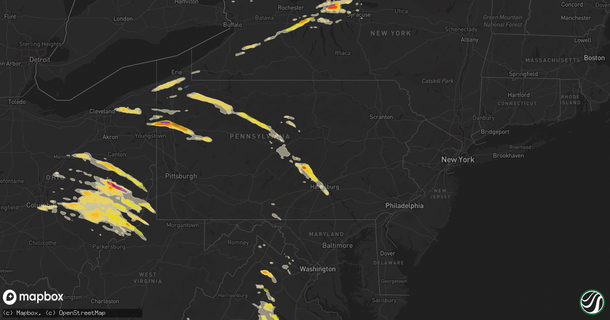
Hail Map in Pennsylvania on June 16, 2022
Get this storm
June 16 map
$229
one time, instant access
Download today. No call, no setup
Keep the $229
Bought the map and want the full workflow? Apply the entire $229 to a subscription within 7 days. None of it is wasted.
Every map, not just this one
This buys you this map. Subscription and you get every map we run, in the markets you choose from a few cities to whole states to nationwide. Plus real-time alerts the moment a storm fires.
Contact data
Name, contact info, occupancy, even credit band for addresses in the footprint. You go from where it hit to who to call.
Become the source they trust
Unlimited branding weather history reports on demand. You already have the documented answer ready for the property owner, and you are the one who showed up with it.
Property data and RoofTrace estimates
Pull up any address you have got, its value and the exact code rules for that jurisdiction, straight from One Click Code. Then RoofTrace estimates the squares, pitch, and roof value, priced the way you price.
Storm reports in Pennsylvania
Pennsylvania
| Date | Description |
|---|---|
| 06/16/20226:38 PM CDT | Report from mping: 3-inch tree limbs broken; power poles broken. |
| 06/16/20226:14 PM CDT | Trees down across route 144 in centre hall. |
| 06/16/20225:18 PM CDT | Powerlines down on hartline road. |
| 06/16/20224:42 PM CDT | Tree and wires down via county dispatch |
| 06/16/20224:35 PM CDT | Trees down on wires along route 555. |
| 06/16/20224:20 PM CDT | Widespread trees and wires down along route 255 north of weedville. |
| 06/16/20224:19 PM CDT | Trees down |
| 06/16/20224:16 PM CDT | Widespread trees and wires down in st. Marys. Tree down through house window on grant street. |
| 06/16/20224:12 PM CDT | Trees snapped or uprooted |
| 06/16/20224:03 PM CDT | A number of trees uprooted along sample road. |
| 06/16/20224:00 PM CDT | Trees down on wires on 241 spruce street. Ridgway borough. |
| 06/16/20223:59 PM CDT | Widespread trees down on wires throughout ridgway. |
| 06/16/20223:55 PM CDT | Trees snapped or uprooted |
| 06/16/20223:36 PM CDT | Trees down |
| 06/16/20223:32 PM CDT | Extensive tree damage reported along mckees rd. Reported no damage to structures. |
| 06/16/20223:31 PM CDT | Multiple trees down |
| 06/16/20223:31 PM CDT | Multiple trees down ny 4467 7453 multiple trees and powerlines down. |
| 06/16/20223:23 PM CDT | Multiple trees down in howe township |
| 06/16/20223:20 PM CDT | Two trees reported down in west hickory. The time was estimated by radar. |
| 06/16/20223:15 PM CDT | Power lines down |
| 06/16/20223:15 PM CDT | Trees and wires down across sheffield. |
| 06/16/20223:15 PM CDT | Multiple trees down throughout clintonville |
| 06/16/20223:15 PM CDT | A local report indicates 1.25 inch wind near 1 NE NECTARINE |
| 06/16/20223:00 PM CDT | A local report indicates 1.00 inch wind near TRANSFER |
| 06/16/20222:58 PM CDT | Widespread trees down across tidioute. |
| 06/16/20222:55 PM CDT | Numerous trees down in cochranton. |
| 06/16/20222:53 PM CDT | A local report indicates 1.75 inch wind near FREDONIA |
| 06/16/20222:53 PM CDT | Picture provided. |
| 06/16/20222:48 PM CDT | A local report indicates 1.75 inch wind near 2 W CLARK |
| 06/16/20222:46 PM CDT | A local report indicates 1.50 inch wind near 1 SE TRANSFER |
| 06/16/20222:46 PM CDT | Numerous trees down on wires around grand valley. |
| 06/16/20222:42 PM CDT | Roof blown off house. |
| 06/16/20222:42 PM CDT | Picture provided. |
| 06/16/20222:40 PM CDT | A local report indicates 1.75 inch wind near TRANSFER |
| 06/16/20222:30 PM CDT | Trees snapped or uprooted |
| 06/16/20222:30 PM CDT | Tree down on clay furnace rd just east of clark |
| 06/16/20222:28 PM CDT | A local report indicates 1.50 inch wind near TRANSFER |
| 06/16/20222:15 PM CDT | Extensive tree damage in union city. Large trees broken and uprooted all over seen on social media. Time estimated from radar. |
| 06/16/20224:59 AM CDT | At 959 PM EDT, a severe thunderstorm was located over Wormleysburg, moving southeast at 20 mph. HAZARD...60 mph wind gusts and quarter size hail. SOURCE...Radar indicated. IMPACT...Hail damage to vehicles is expected. Expect wind damage to roofs, siding, and trees. Locations impacted include... Harrisburg, York, Lower Allen, Weigelstown, Progress, Mechanicsburg, Middletown, Camp Hill, New Cumberland, Enola, Steelton and Lemoyne.This includes the following Interstates... The Pennsylvania Turnpike from mile markers 236 to 249. Interstate 81 from mile markers 64 to 68. Interstate 83 from mile markers 22 to 47. Interstate 283 from mile markers 0 to 2. |
| 06/16/20224:04 AM CDT | At 904 AM EDT, a severe thunderstorm was located over Strasburg, moving southeast at 35 mph. HAZARD...60 mph wind gusts and penny size hail. SOURCE...Radar indicated. IMPACT...Expect damage to roofs, siding, and trees. This severe thunderstorm will be near... Gap around 910 AM EDT.Other locations impacted by this severe thunderstorm includeChristiana, Buck, Gordonville, Bird-In-Hand and Refton. |
| 06/16/20223:59 AM CDT | At 858 PM EDT, a severe thunderstorm was located over Duncannon, moving southeast at 25 mph. HAZARD...60 mph wind gusts and half dollar size hail. SOURCE...Radar indicated. IMPACT...Hail damage to vehicles is expected. Expect wind damage to roofs, siding, and trees. Locations impacted include... Harrisburg, Carlisle, Lower Allen, Colonial Park, Progress, Mechanicsburg, Middletown, Camp Hill, New Cumberland, Enola, Steelton and Lemoyne.This includes the following Interstates... The Pennsylvania Turnpike between mile markers 224 and 239...andfrom mile markers 247 to 253. Interstate 81 from mile markers 48 to 68. Interstate 83 from mile markers 40 to 48. Interstate 283 from mile markers 0 to 2. |
| 06/16/20223:17 AM CDT | At 817 PM EDT, a severe thunderstorm was located over Mexico, moving southeast at 30 mph. HAZARD...Two inch hail and 60 mph wind gusts. SOURCE...Radar indicated. IMPACT...People and animals outdoors will be injured. Expect hail damage to roofs, siding, windows, and vehicles. Expect wind damage to roofs, siding, and trees. Locations impacted include... Marysville, Newport, Duncannon, New Bloomfield, Spruce Hill, Mexico, Loysville, Ickesburg, Walnut, Shermansdale, Rockville and Mifflintown. |
| 06/16/20222:26 AM CDT | At 726 PM EDT, a severe thunderstorm was located over Potters Mills, moving southeast at 30 mph. HAZARD...60 mph wind gusts and quarter size hail. SOURCE...Radar indicated. IMPACT...Hail damage to vehicles is expected. Expect wind damage to roofs, siding, and trees. Locations impacted include... Lewistown, Boalsburg, Pleasant Gap, Lemont, Burnham, Houserville, Milroy, Highland Park, Centre Hall, Yeagertown, McClure and Reedsville. |
| 06/16/20221:42 AM CDT | At 642 PM EDT, severe thunderstorms were located along a line extending from Bald Eagle State Park to Julian, moving southeast at 25 mph. HAZARD...60 mph wind gusts and penny size hail. SOURCE...Radar indicated. IMPACT...Expect damage to roofs, siding, and trees. Locations impacted include... Bellefonte, Woodward, Pleasant Gap, Lamar, Zion, Centre Hall, Milesburg, Millheim, Aaronsburg, Rebersburg, Spring Mills and Coburn.For those driving on Interstate 80, this includes areas between theMilesburg and Lamar exits, specifically from mile markers 158 to 171.This includes Interstate 99 from mile markers 77 to 85. |
| 06/16/20221:17 AM CDT | At 617 PM EDT, a severe thunderstorm was located over Snow Shoe, moving southeast at 40 mph. THIS IS A DESTRUCTIVE STORM FOR NORTHERN CENTRE COUNTY. HAZARD...80 mph wind gusts and quarter size hail. SOURCE...Radar indicated. IMPACT...Flying debris will be dangerous to those caught without shelter. Mobile homes will be heavily damaged. Expect considerable damage to roofs, windows, and vehicles. Extensive tree damage and power outages are likely. Locations impacted include... Bellefonte, Zion, Milesburg, Snow Shoe, Clarence, Moshannon, Julian and Unionville.For those driving on Interstate 80, this includes areas between theKylertown and Lamar exits, specifically from mile markers 143 to 163.This includes Interstate 99 from mile markers 83 to 85. |
| 06/16/20221:11 AM CDT | At 611 PM EDT, a severe thunderstorm was located over Cameron, or 12 miles southeast of Moundsville, moving southeast at 40 mph. HAZARD...60 mph wind gusts and quarter size hail. SOURCE...Radar indicated. IMPACT...Minor hail damage to vehicles is possible. Expect wind damage to trees and power lines, resulting in some power outages. Locations impacted include... Mannington, Cameron, Fairview, Hundred, Cassville, Rogersville, Grant Town, Farmington, Aleppo, Blacksville, Spraggs, and Mount Morris. |
| 06/16/20221:00 AM CDT | At 559 PM EDT, a severe thunderstorm was located near Keating, moving east at 40 mph. HAZARD...70 mph wind gusts and half dollar size hail. SOURCE...Radar indicated. IMPACT...Hail damage to vehicles is expected. Expect considerable tree damage. Wind damage is also likely to mobile homes, roofs, and outbuildings. Locations impacted include... Lock Haven, Keating, Lamar, Mill Hall, Dunnstown, Flemington, Castanea, Blanchard, Clarence, Pine Glen, Monument and Bald Eagle State Park.For those driving on Interstate 80, this includes areas between theBellefonte and Loganton exits, specifically from mile markers 163 to182.This includes the following highways... Route 220 from west of Lamar on I-80 to Lock Haven. State Road 120 from north of Lock Haven to Lock Haven. |
| 06/16/202212:54 AM CDT | At 553 PM EDT, a severe thunderstorm was located over Glen Union or about 10 miles east of Renovo, moving east at 40 mph. HAZARD...60 mph wind gusts and half dollar size hail. SOURCE...Radar indicated. IMPACT...Hail damage to vehicles is expected. Expect wind damage to roofs, siding, and trees. This severe thunderstorm will be near... Avis, McElhattan and Waterville around 610 PM EDT. Jersey Shore around 620 PM EDT.Other locations impacted by this severe thunderstorm includeSalladasburg.This includes the following highways... Route 220 from Avis to Jersey Shore. State Road 120 near Hyner View State Park. |
| 06/16/202212:39 AM CDT | At 538 PM EDT, a severe thunderstorm produccing widespread wind damage was located near Hicks Run, moving east at 40 mph. HAZARD...70 mph wind gusts and half dollar size hail. SOURCE...Radar indicated. IMPACT...Hail damage to vehicles is expected. Expect considerable tree damage. Wind damage is also likely to mobile homes, roofs, and outbuildings. Locations impacted include... Keating, Karthaus and Pine Glen. |
| 06/16/202212:17 AM CDT | At 517 PM EDT, a severe thunderstorm was located 9 miles west of Brockway, or 9 miles northeast of Brookville, moving east at 45 mph. HAZARD...60 mph wind gusts and quarter size hail. SOURCE...Radar indicated. IMPACT...Minor hail damage to vehicles is possible. Expect wind damage to trees and power lines, resulting in some power outages. Locations impacted include... Brockway. |
| 06/16/202212:08 AM CDT | At 508 PM EDT, a severe thunderstorm was located near New Bethlehem, or 7 miles east of Rimersburg, moving east at 40 mph. HAZARD...Ping pong ball size hail and 60 mph wind gusts. SOURCE...Radar indicated. IMPACT...People and animals outdoors will be injured. Expect hail damage to roofs, siding, windows, and vehicles. Expect wind damage to trees and power lines, resulting in some power outages. Locations impacted include... Punxsutawney, Brookville, Rimersburg, Reynoldsville, New Bethlehem, Sykesville, Falls Creek, Sligo, Big Run, Dayton, Summerville, and Rossiter. |
| 06/15/202211:56 PM CDT | At 456 PM EDT, a severe thunderstorm was located 8 miles southwest of Marienville, moving east at 45 mph. HAZARD...60 mph wind gusts and half dollar size hail. SOURCE...Radar indicated. IMPACT...Minor hail damage to vehicles is possible. Expect wind damage to trees and power lines, resulting in some power outages. Locations impacted include... Sigel, Fisher, Leeper, Clarington, Clear Creek State Park, and Cook Forest State Park. |
| 06/15/202211:53 PM CDT | At 453 PM EDT, a severe thunderstorm was located 8 miles east of Cadiz, moving southeast at 40 mph. HAZARD...Ping pong ball size hail and 60 mph wind gusts. SOURCE...Radar indicated. IMPACT...People and animals outdoors will be injured. Expect hail damage to roofs, siding, windows, and vehicles. Expect wind damage to trees and power lines, resulting in some power outages. Locations impacted include... Wheeling, Weirton, Steubenville, Martins Ferry, Cadiz, Warwood, Wellsburg, West Liberty, Triadelphia, Avella, Clearview, and Valley Grove. |
| 06/15/202211:27 PM CDT | At 427 PM EDT, a severe thunderstorm was located 14 miles northeast of Slippery Rock, or 14 miles east of Grove City, moving southeast at 45 mph. HAZARD...Ping pong ball size hail and 60 mph wind gusts. SOURCE...Radar indicated. IMPACT...People and animals outdoors will be injured. Expect hail damage to roofs, siding, windows, and vehicles. Expect wind damage to trees and power lines, resulting in some power outages. Locations impacted include... Clarion, Knox, Rimersburg, New Bethlehem, East Brady, Parker, Sligo, Emlenton, Strattanville, Bruin, Clintonville, and Limestone. |
| 06/15/202211:25 PM CDT | At 424 PM EDT, a severe thunderstorm was located over James City, moving east at 50 mph. HAZARD...70 mph wind gusts and half dollar size hail. SOURCE...Radar indicated. IMPACT...Hail damage to vehicles is expected. Expect considerable tree damage. Wind damage is also likely to mobile homes, roofs, and outbuildings. This severe thunderstorm will be near... James City around 430 PM EDT. Johnsonburg and Wilcox around 440 PM EDT. East Branch Dam around 450 PM EDT. Truman and Elk River around 500 PM EDT. Emporium around 510 PM EDT.Other locations impacted by this severe thunderstorm includeWeedville and Kersey.This includes the following highways... Route 219 from Brockport to north of Wilcox. State Road 66 from Russell City to James City. State Road 120 from Ridgway to Emporium. State Road 255 from north of Penfield to Johnsonburg. |
| 06/15/202211:18 PM CDT | At 417 PM EDT, a severe thunderstorm was located near Orwell, or 17 miles north of Warren, moving east at 45 mph. HAZARD...Golf ball size hail and 60 mph wind gusts. SOURCE...Radar indicated. IMPACT...People and animals outdoors will be injured. Expect hail damage to roofs, siding, windows, and vehicles. Expect damage to trees and power lines. Locations impacted include... Kinsman, Andover, Linesville, Harmonsburg, Adamsville, Pymatuning North, Pymatuning Central, Atlantic, Mecca, Johnston, Cherry Valley, Conneaut Lake, Jamestown, Conneaut Lakeshore, Geneva and Hartstown. |
| 06/15/202211:15 PM CDT | At 415 AM EDT, a severe thunderstorm was located near Hortonville, or 13 miles west of Liberty, moving east at 25 mph. HAZARD...60 mph wind gusts and quarter size hail. SOURCE...Radar indicated. IMPACT...Hail damage to vehicles is expected. Expect wind damage to roofs, siding, and trees. Locations impacted include... Fallsburg, Liberty, Neversink, South Fallsburg, Callicoon, Fremont, Woodridge, Jeffersonville, Parksville and Swan Lake. |
| 06/15/202210:57 PM CDT | At 357 PM EDT, a severe thunderstorm was located 10 miles northwest of Grove City, moving east at 45 mph. HAZARD...Two inch hail and 60 mph wind gusts. SOURCE...Radar indicated. IMPACT...People and animals outdoors will be injured. Expect hail damage to roofs, siding, windows, and vehicles. Expect wind damage to trees and power lines, resulting in some power outages. Locations impacted include... Franklin, Knox, Mercer, Stoneboro, Seneca, Polk, Sandy Lake, Emlenton, Clintonville, Fredonia, St. Petersburg, and Eau Claire. |
| 06/15/202210:55 PM CDT | At 355 PM EDT, a severe thunderstorm was located 10 miles northwest of Franklin, moving east at 45 mph. HAZARD...60 mph wind gusts and quarter size hail. SOURCE...Radar indicated. IMPACT...Minor hail damage to vehicles is possible. Expect wind damage to trees and power lines, resulting in some power outages. Locations impacted include... Oil City, Franklin, Marienville, Sugarcreek, Tionesta, Hasson Heights, Seneca, Rouseville, Cooperstown, Woodland Heights, Pleasantville, and Utica. |
| 06/15/202210:47 PM CDT | At 347 PM EDT, a severe thunderstorm was located over Grand Valley, moving east at 45 mph. HAZARD...70 mph wind gusts and quarter size hail. SOURCE...Radar indicated. IMPACT...Hail damage to vehicles is expected. Expect considerable tree damage. Wind damage is also likely to mobile homes, roofs, and outbuildings. Locations impacted include... Sheffield, Grand Valley, Chapman State Park, Tidioute and Clarendon. |
| 06/15/202210:36 PM CDT | At 335 PM EDT, severe thunderstorms were located along a line extending from Arcade to near Falconer, moving east at 45 mph. HAZARD...60 mph wind gusts and quarter size hail. SOURCE...Radar indicated. IMPACT...Minor damage to vehicles is possible. Expect wind damage to trees and power lines. Locations impacted include... Jamestown, Olean, Salamanca, Letchworth State Park, Allegany State Park, Springville, Perry, Mount Morris, Falconer and Ashford.This includes the following highways... Interstate 390 near exit 6. Interstate 86 between exits 8 and 31. |
| 06/15/202210:24 PM CDT | At 324 PM EDT, a severe thunderstorm was located near Claylick, or near Greencastle, moving southeast at 25 mph. HAZARD...60 mph wind gusts and quarter size hail. SOURCE...Radar indicated. IMPACT...Damaging winds will cause some trees and large branches to fall. This could injure those outdoors, as well as damage homes and vehicles. Roadways may become blocked by downed trees. Localized power outages are possible. Unsecured light objects may become projectiles. Locations impacted include... Hagerstown, Municipal Stadium, Robinwood, Fountainhead-Orchard Hills, Smithsburg, Paramount-Long Meadow, Wilson-Conococheague, Mount Aetna, Mount Lena, San Mar, Long Meadow, Wolfsville, Halfway, Maugansville, Myersville, Cavetown, Funkstown, Leitersburg, Sabillasville and Fort Ritchie. |
| 06/15/202210:14 PM CDT | At 314 PM EDT, a severe thunderstorm was located over Harmonsburg, or 9 miles west of Meadville, moving east at 45 mph. HAZARD...Ping pong ball size hail and 60 mph wind gusts. SOURCE...Radar indicated. IMPACT...People and animals outdoors will be injured. Expect hail damage to roofs, siding, windows, and vehicles. Expect damage to trees and power lines. Locations impacted include... Meadville, Titusville, Linesville, Adamsville, Pymatuning Central, Riceville, Harmonsburg, Lincolnville, Guys Mills, Pymatuning North, Atlantic, Canadohta Lake, Cochranton, Saegertown, Conneautville, Conneaut Lake, Jamestown, Hydetown, Blooming Valley and Townville. |
| 06/15/20229:46 PM CDT | At 246 PM EDT, severe thunderstorms were located along the I-90 ridge line northwest of Warren County, moving to the east at 35 mph. HAZARD...60 mph wind gusts. SOURCE...Radar indicated. IMPACT...Expect damage to roofs, siding, and trees. Locations impacted include... Columbus, Youngsville, Russell, Spring Creek, Lottsville, Enterprise, Garland, Grand Valley, Sugar Grove, Starbrick and Bear Lake.This includes the following highways... Route 6 from Columbus to Starbrick. Route 62 between south of Irvine and Starbrick...and from Warren tothe New York border. |
| 06/15/20229:25 PM CDT | A local report indicates 1.00 inch wind near 2 WSW MAYTOWN |
| 06/15/20229:15 PM CDT | A local report indicates 1.00 inch wind near 2 NNW VALLEY GREEN |
| 06/15/20229:10 PM CDT | At 209 PM EDT, a severe thunderstorm was located over Fort Littleton, moving east at 20 mph. HAZARD...60 mph wind gusts and quarter size hail. SOURCE...Radar indicated. IMPACT...Hail damage to vehicles is expected. Expect wind damage to roofs, siding, and trees. This severe thunderstorm will be near... Fort Loudon around 210 PM EDT. Fannettsburg and St. Thomas around 230 PM EDT. Willow Hill around 240 PM EDT. Upper Strasburg around 250 PM EDT. Chambersburg, Shippensburg and Roxbury around 300 PM EDT.Other locations impacted by this severe thunderstorm includeOrrstown.This includes the following Interstates... The Pennsylvania Turnpike between mile markers 175 and 184...betweenmile markers 187 and 194...and from mile markers 198 to 201. Interstate 81 from mile markers 14 to 24. |
| 06/15/20228:55 PM CDT | Wires down. |
| 06/15/20228:10 PM CDT | Tree down on bloomfield rd. |
| 06/15/20228:00 PM CDT | Tree down on municipal building road. |
| 06/15/20228:00 PM CDT | Trees down at buttonwood campground. |
| 06/15/20227:40 PM CDT | Damage on gill hill rd. Time based on radar. |
| 06/15/20227:25 PM CDT | Via twitter. |
| 06/15/20227:21 PM CDT | Considerable damage to church. Time based on radar. |
| 06/15/20227:19 PM CDT | Via twitter. |
| 06/15/20227:00 PM CDT | Old fort road |
All States Impacted by Hail Map on June 16, 2022
Cities Impacted by Hail Map on June 16, 2022
- Fort Covington, NY
- Brushton, NY
- Oswego, NY
- Hannibal, NY
- Fine, NY
- Fulton, NY
- Clay, NY
- Brewerton, NY
- Trenton, MO
- Spickard, MO
- North Bend, PA
- Lock Haven, PA
- Chaumont, NY
- Bellwood, NE
- David City, NE
- Bethany, MO
- Ridgeway, MO
- Martinsville, MO
- Ransomville, NY
- Wilson, NY
- Canandaigua, NY
- Stanley, NY
- Bloomfield, IA
- Moulton, IA
- Verdon, NE
- Salem, NE
- Humboldt, NE
- Falls City, NE
- Dawson, NE
- Lacona, NY
- Sandy Creek, NY
- Pulaski, NY
- Chaffee, NY
- West Valley, NY
- East Concord, NY
- Bliss, NY
- Sardinia, NY
- Springville, NY
- Arcade, NY
- Delevan, NY
- Yorkshire, NY
- Saegertown, PA
- Cambridge Springs, PA
- Hastings, IA
- Johnstown, OH
- Massena, NY
- Gouverneur, NY
- Theresa, NY
- Antwerp, NY
- Fort Drum, NY
- Philadelphia, NY
- Watertown, NY
- Rodman, NY
- La Fargeville, NY
- Abie, NE
- Bruno, NE
- Linwood, NE
- Honeoye Falls, NY
- Victor, NY
- Frederick, IL
- Mount Sterling, IL
- Rushville, IL
- Browning, IL
- Timewell, IL
- Elkhart, IL
- Garden Grove, IA
- Allerton, IA
- Princeton, MO
- Waterford, PA
- Edinboro, PA
- Wattsburg, PA
- Conneaut, OH
- McKean, PA
- Albion, PA
- Girard, PA
- Cranesville, PA
- Union City, PA
- Kingsville, OH
- Erie, PA
- Springboro, PA
- Shortsville, NY
- Palmyra, NY
- Farmington, NY
- Wolbach, NE
- Corning, IA
- Hermon, NY
- Eagleville, MO
- Hatfield, MO
- Cape Vincent, NY
- Clayton, NY
- Pennellville, NY
- Memphis, NY
- Clyde, NY
- Central Square, NY
- Cato, NY
- Jordan, NY
- Red Creek, NY
- Martville, NY
- Savannah, NY
- Wolcott, NY
- Sterling, NY
- Phoenix, NY
- Weedsport, NY
- Port Byron, NY
- Lyons, NY
- Sodus, NY
- North Rose, NY
- Baldwinsville, NY
- Brewster, OH
- Navarre, OH
- Geneseo, NY
- Clifton Springs, NY
- Leicester, NY
- Manchester, NY
- Phelps, NY
- Conesus, NY
- Bloomfield, NY
- Honeoye, NY
- Silver Springs, NY
- Gainesville, NY
- Silver Lake, NY
- Mount Morris, NY
- Perry, NY
- Hemlock, NY
- Castile, NY
- Lima, NY
- Livonia, NY
- Hammond, NY
- De Peyster, NY
- Cattaraugus, NY
- East Otto, NY
- Snow Shoe, PA
- Moshannon, PA
- Drakesville, IA
- Syracuse, NY
- Liverpool, NY
- Conneautville, PA
- Greenville, PA
- Kinsman, OH
- Fowler, OH
- Burghill, OH
- Farmdale, OH
- Howard, OH
- Gambier, OH
- Gilman City, MO
- Kellerton, IA
- Lamoni, IA
- Landisburg, PA
- Sherman, NY
- Findley Lake, NY
- Clymer, NY
- Newark, NY
- Jamesville, NY
- Auburn, NY
- Copenhagen, NY
- Clarence, PA
- Pottersdale, PA
- James City, PA
- Weedville, PA
- Clarendon, PA
- Kersey, PA
- Bellefonte, PA
- Benezett, PA
- Tidioute, PA
- Centerville, PA
- Spartansburg, PA
- Driftwood, PA
- Grand Valley, PA
- Titusville, PA
- Sheffield, PA
- Saint Marys, PA
- Howard, PA
- Pittsfield, PA
- Ridgway, PA
- Johnsonburg, PA
- Sinnamahoning, PA
- Marienville, PA
- Kane, PA
- Tionesta, PA
- Karthaus, PA
- Kersey, CO
- Greeley, CO
- La Salle, CO
- Geneva, NY
- Fremont, IN
- Angola, IN
- Edon, OH
- Warren, OH
- Vienna, OH
- Emlenton, PA
- Masury, OH
- Jackson Center, PA
- Transfer, PA
- Petrolia, PA
- Stoneboro, PA
- Parker, PA
- Mercer, PA
- Eau Claire, PA
- Harrisville, PA
- Rimersburg, PA
- Hermitage, PA
- Fredonia, PA
- Fairmount City, PA
- Clintonville, PA
- Cortland, OH
- Hilliards, PA
- Clark, PA
- West Sunbury, PA
- Karns City, PA
- New Bethlehem, PA
- Boyers, PA
- Grove City, PA
- Sligo, PA
- Sharpsville, PA
- Polk, PA
- Bruin, PA
- Kennerdell, PA
- North Bloomfield, OH
- Chardon, OH
- Huntsburg, OH
- Middlefield, OH
- Novelty, OH
- Chesterland, OH
- Orwell, OH
- Newbury, OH
- Burton, OH
- Windsor, OH
- Gates Mills, OH
- Russell, NY
- Medina, NY
- Middleport, NY
- Richville, NY
- De Kalb Junction, NY
- Redwood, NY
- Grand River, IA
- Albany, MO
- New Hampton, MO
- McFall, MO
- Tingley, IA
- Ellston, IA
- Browning, MO
- Laredo, MO
- Chula, MO
- Humphreys, MO
- Franklin, PA
- Cooperstown, PA
- Eagle Rock, VA
- Clifton Forge, VA
- Mulberry Grove, IL
- Bingham, IL
- Ramsey, IL
- Fillmore, IL
- Coffeen, IL
- Galt, MO
- Renovo, PA
- Statesville, NC
- Glenwood, IA
- Malvern, IA
- Pacific Junction, IA
- Tecumseh, NE
- Rockport, IL
- Pittsfield, IL
- Pleasant Hill, IL
- Benton, IA
- Clearfield, IA
- Bedford, IA
- Blockton, IA
- Rutherfordton, NC
- Chesnee, SC
- Clarence, MO
- Lentner, MO
- Powersville, MO
- Seymour, IA
- Lucerne, MO
- Newtown, MO
- Lineville, IA
- Pollock, MO
- Harris, MO
- Mercer, MO
- Unionville, MO
- Milan, MO
- Corydon, IA
- Clinton, NC
- Richwoods, MO
- Lonedell, MO
- Sullivan, MO
- Hoxie, KS
- Bland, VA
- Alpharetta, GA
- Morrisonville, IL
- Nokomis, IL
- Clover, SC
- Belmont, NC
- Gastonia, NC
- Darlington, SC
- Long Island, VA
- Greencastle, PA
- Clear Spring, MD
- Hagerstown, MD
- Mercersburg, PA
- Pisgah Forest, NC
- High Point, NC
- Jamestown, NC
- Ashland, IL
- Liberty, IL
- Mendenhall, MS
- Salem, WV
- Vesuvius, VA
- Lincolnton, NC
- Maybeury, WV
- Pocahontas, VA
- Bluefield, VA
- Welch, WV
- Bramwell, WV
- Luray, MO
- Queen City, MO
- Gibbs, MO
- Kirksville, MO
- Shelbyville, MO
- Brashear, MO
- Milton, IA
- La Plata, MO
- Cantril, IA
- Baring, MO
- Memphis, MO
- Atlanta, MO
- Hurdland, MO
- Bethel, MO
- Knox City, MO
- Rutledge, MO
- Novinger, MO
- Greentop, MO
- Farmington, IA
- Keosauqua, IA
- Mount Sterling, IA
- Bonaparte, IA
- Novelty, MO
- Kahoka, MO
- Pulaski, IA
- Downing, MO
- Edina, MO
- Arbela, MO
- La Belle, MO
- Lancaster, MO
- Newark, MO
- Green Castle, MO
- Leonard, MO
- Roanoke, VA
- Salem, VA
- Mifflin, PA
- McAlisterville, PA
- McClure, PA
- Millerstown, PA
- Mifflintown, PA
- Shermans Dale, PA
- Port Royal, PA
- Newport, PA
- Oakland Mills, PA
- New Bloomfield, PA
- Duncannon, PA
- Lewistown, PA
- Thompsontown, PA
- Marianna, FL
- Grand Ridge, FL
- Oconee, IL
- Pana, IL
- Six Mile, SC
- Central, SC
- Aldie, VA
- Leesburg, VA
- Gretna, VA
- Chatham, VA
- Java, VA
- West Union, WV
- Bluford, IL
- Dix, IL
- Irvington, IL
- Centralia, IL
- Johnsonville, IL
- Keenes, IL
- Walnut Hill, IL
- Texico, IL
- Kell, IL
- Mount Vernon, IL
- Iuka, IL
- Pelham, NC
- Ruffin, NC
- Reidsville, NC
- Tarkio, MO
- Watson, MO
- Rock Port, MO
- Westboro, MO
- Winston, GA
- Whitesburg, GA
- Clio, SC
- Blenheim, SC
- Bennettsville, SC
- Bentonia, MS
- Benton, MS
- Rapidan, VA
- Reva, VA
- Boston, VA
- Culpeper, VA
- Mitchells, VA
- West, MS
- Sallis, MS
- Elba, AL
- Kinston, AL
- Samson, AL
- Quincy, FL
- Montpelier, VA
- Rockville, VA
- Northport, AL
- Purcellville, VA
- Scarbro, WV
- Mount Hope, WV
- Fayetteville, WV
- Kincaid, WV
- Maidens, VA
- Powhatan, VA
- Palmyra, VA
- Goochland, VA
- Crozier, VA
- Pratts, VA
- Louisa, VA
- Madison, VA
- Columbia, VA
- Barboursville, VA
- Sandy Hook, VA
- Keswick, VA
- Somerset, VA
- Rochelle, VA
- Aroda, VA
- Unionville, VA
- Troy, VA
- Gum Spring, VA
- Radiant, VA
- Ruckersville, VA
- Gordonsville, VA
- Mineral, VA
- Kents Store, VA
- Stanardsville, VA
- State Farm, VA
- Orange, VA
- Bumpass, VA
- Tiger, GA
- Lakemont, GA
- Hardy, VA
- Bessemer City, NC
- Fort Lupton, CO
- Hudson, CO
- Sylacauga, AL
- Talladega, AL
- Goodwater, AL
- Stockport, OH
- Waterford, OH
- Newport, VA
- Union Mills, NC
- Lake Lure, NC
- Tryon, NC
- Mill Spring, NC
- Thomasville, NC
- Winston Salem, NC
- Northfork, WV
- Kimball, WV
- Brookneal, VA
- Nathalie, VA
- Gladys, VA
- Ellerbe, NC
- Emerson, IA
- Red Oak, IA
- Old Fort, NC
- Marion, NC
- Macon, NC
- Warrenton, NC
- Campobello, SC
- Greer, SC
- Landrum, SC
- McBee, SC
- Bethune, SC
- Jefferson, SC
- Dwight, NE
- Browns Summit, NC
- Nashville, NC
- Chattahoochee, FL
- Bainbridge, GA
- Sneads, FL
- Coatsburg, IL
- Camp Point, IL
- Paloma, IL
- Quincy, IL
- Clayton, IL
- Fowler, IL
- Quinton, AL
- Dora, AL
- Cordova, AL
- Marion, SC
- Norwood, LA
- Kershaw, SC
- Covington, VA
- Marble Hill, MO
- Vinton, LA
- Greensboro, NC
- Summerfield, NC
- McLeansville, NC
- Eastover, SC
- Dalzell, SC
- Rembert, SC
- Weeping Water, NE
- Carlisle, SC
- Whitmire, SC
- Newberry, SC
- Union, SC
- Tuskegee, AL
- Camillus, NY
- Warners, NY
- Joanna, SC
- Kinards, SC
- Silverstreet, SC
- Hopkins, SC
- Randolph, AL
- Jemison, AL
- Brierfield, AL
- Norfolk, NY
- Chase Mills, NY
- Friend, NE
- Cordova, NE
- York, NE
- Waco, NE
- McCool Junction, NE
- Exeter, NE
- Beaver Crossing, NE
- Glenmont, OH
- Danville, OH
- Lewistown, MO
- Chesterhill, OH
- Marine, IL
- Alhambra, IL
- Rushville, OH
- Somerset, OH
- Thornville, OH
- Penokee, KS
- Hill City, KS
- Morland, KS
- Baylis, IL
- Versailles, IL
- Griggsville, IL
- Chambersburg, IL
- Orrick, MO
- Lamar, CO
- Gainesville, VA
- Haymarket, VA
- Jonesville, NC
- Hamptonville, NC
- Lerona, WV
- Peterstown, WV
- Pipestem, WV
- Halifax, VA
- Crystal Hill, VA
- Wilson, NC
- Lucama, NC
- McConnells, SC
- Chester, SC
- Trinity, NC
- New Castle, VA
- Elizabethtown, NC
- Garland, NC
- Pinewood, SC
- Summerton, SC
- Bishopville, SC
- Camden, SC
- Cassatt, SC
- Saluda, SC
- Ward, SC
- Picayune, MS
- Troy, AL
- Louisville, AL
- Clayton, AL
- Perkinston, MS
- Smithdale, MS
- Liberty, MS
- Orangeburg, SC
- Cordova, SC
- Warsaw, IL
- Basco, IL
- Golden, IL
- West Point, IL
- Bowen, IL
- Lewisberry, PA
- Etters, PA
- New Cumberland, PA
- Bremen, OH
- Ronceverte, WV
- Sinks Grove, WV
- Alderson, WV
- Estes Park, CO
- Heath, OH
- Granville, OH
- Newark, OH
- Camp Hill, PA
- Summerdale, PA
- Enola, PA
- Marysville, PA
- Mechanicsburg, PA
- Elliottsburg, PA
- Harrisburg, PA
- York Haven, PA
- Lemoyne, PA
- Nashport, OH
- Butler, OH
- Wheeler, IL
- Loveland, CO
- Berthoud, CO
- Webster Springs, WV
- Eskdale, WV
- Gallagher, WV
- Montgomery, WV
- Martinsburg, WV
- Hedgesville, WV
- Hamilton, VA
- Clay City, IL
- Flora, IL
- Hillsboro, IL
- Donnellson, IL
- Philadelphia, MO
- Monroe City, MO
- Crawley, WV
- Smoot, WV
- Rainelle, WV
- Highland, IL
- Pocahontas, IL
- Greenville, IL
- Carlyle, IL
- Breese, IL
- White Sulphur Springs, WV
- Ballard, WV
- Union, WV
- Greenville, WV
- Ripplemead, VA
- Lindside, WV
- Pembroke, VA
- Narrows, VA
- Martinsville, VA
- Patrick Springs, VA
- Bassett, VA
- Fieldale, VA
- Clinton, SC
- Laurens, SC
- Morganton, NC
- Mayesville, SC
- Gable, SC
- Hamer, SC
- Gibson, NC
- Hamlet, NC
- Laurinburg, NC
- Little Rock, SC
- Maxton, NC
- Rowland, NC
- Laurel Hill, NC
- Rockingham, NC
- McColl, SC
- Dillon, SC
- Monroe, NC
- Liberty Hill, SC
- Ridgeway, SC
- Heath Springs, SC
- Blackstock, SC
- Great Falls, SC
- Winnsboro, SC
- Maysville, GA
- Lamar, SC
- Timmonsville, SC
- Lawrenceville, GA
- Suwanee, GA
- Saint Francisville, LA
- Carriere, MS
- Mulga, AL
- Brundidge, AL
- Banks, AL
- Oakdale, LA
- Glenmora, LA
- Quaker City, OH
- Salesville, OH
- Milroy, PA
- Cook, NE
- Fredericktown, OH
- Cleveland, SC
- Marietta, SC
- Pickens, SC
- Evans, CO
- Villisca, IA
- Elliott, IA
- Green City, MO
- Rosebud, MO
- Owensville, MO
- Windsor, IL
- Strasburg, IL
- Neoga, IL
- Raleigh, NC
- Alexander, IL
- Jacksonville, IL
- Lemont, PA
- Huntingdon, PA
- Julian, PA
- Spring Mills, PA
- Centre Hall, PA
- University Park, PA
- State College, PA
- Boalsburg, PA
- Milesburg, PA
- Port Matilda, PA
- Humeston, IA
- Weldon, IA
- Decatur, IA
- Van Wert, IA
- Leon, IA
- Millersport, OH
- Pleasantville, OH
- Thurston, OH
- Baltimore, OH
- Lenox, IA
- Sharpsburg, IA
- Gravity, IA
- Lawndale, NC
- Cherryville, NC
- Udell, IA
- Unionville, IA
- Moravia, IA
- Centerville, IA
- Anabel, MO
- Pinnacle, NC
- Highland, KS
- Reedsville, PA
- Pilot Mountain, NC
- South Boston, VA
- Tribune, KS
- Ararat, NC
- Beardstown, IL
- Harrisburg, NC
- Landis, NC
- Concord, NC
- Charlotte, NC
- Kannapolis, NC
- China Grove, NC
- Matthews, NC
- Pennsboro, WV
- Perryville, MO
- Winchester, VA
- Hull, IL
- Sunset, SC
- Candor, NC
- Jackson Springs, NC
- Robbins, NC
- Seagrove, NC
- Eagle Springs, NC
- Star, NC
- Biscoe, NC
- Lashmeet, WV
- Matoaka, WV
- Beeson, WV
- Rock, WV
- Berkeley Springs, WV
- Lancaster, SC
- Mode, IL
- Stewardson, IL
- Shelbyville, IL
- Girard, IL
- Waggoner, IL
- Farmersville, IL
- Lugoff, SC
- Blythewood, SC
- Columbia, SC
- Elgin, SC
- Danielsville, GA
- Carnesville, GA
- Royston, GA
- Commerce, GA
- Harmony, NC
- Union Grove, NC
- Heflin, AL
- Munford, AL
- Oxford, AL
- Delta, AL
- Anniston, AL
- Alcolu, SC
- Dorchester, NE
- Crete, NE
- Columbus, NC
- Table Rock, NE
- The Plains, VA
- Middleburg, VA
- Rocky Gap, VA
- Bluefield, WV
- Princeton, WV
- Kennesaw, GA
- Marietta, GA
- Jane Lew, WV
- Glenville, WV
- Crawford, WV
- Orlando, WV
- French Creek, WV
- Camden, WV
- Tallmansville, WV
- Buckhannon, WV
- Rock Cave, WV
- Helvetia, WV
- Walkersville, WV
- Adrian, WV
- Horner, WV
- Weston, WV
- New Milton, WV
- Burnsville, WV
- Copen, WV
- Sand Fork, WV
- Linn, WV
- Alum Bridge, WV
- Pickens, WV
- Wytheville, VA
- Ceres, VA
- Ferrum, VA
- Valparaiso, NE
- Brainard, NE
- Ashland, NE
- Cottondale, FL
- Campbellton, FL
- Chipley, FL
- Graceville, FL
- Alford, FL
- Bonifay, FL
- Sebree, KY
- Slaughters, KY
- Calhoun, KY
- New Douglas, IL
- Livingston, IL
- Staunton, IL
- North Tazewell, VA
- Falls Mills, VA
- Bastian, VA
- Alvo, NE
- Murdock, NE
- Greenwood, NE
- Hosford, FL
- Daleville, VA
- Vinton, VA
- Troutville, VA
- Catawba, VA
- Cloverdale, VA
- Travelers Rest, SC
- Benwood, WV
- Mcmechen, WV
- Cameron, WV
- Glen Dale, WV
- Wheeling, WV
- Jacobsburg, OH
- Moundsville, WV
- Bellaire, OH
- Glen Easton, WV
- Shadyside, OH
- Marshville, NC
- Wingate, NC
- Hartsville, SC
- Hurt, VA
- Altavista, VA
- Lynch Station, VA
- Friedheim, MO
- Oak Ridge, MO
- Daisy, MO
- Elon, NC
- Gibsonville, NC
- Newton, NC
- Lyman, SC
- Inman, SC
- Atlanta, GA
- Birmingham, AL
- Docena, AL
- Adamsville, AL
- Vale, NC
- Hickory, NC
- Bristol, FL
- Vernon Hill, VA
- Greenwood, FL
- Brevard, NC
- Belton, SC
- Williamston, SC
- Chancellor, AL
- Stokesdale, NC
- Belews Creek, NC
- Coffee Springs, AL
- Panacea, FL
- Cowpens, SC
- Spartanburg, SC
- Boiling Springs, SC
- Chesterville, OH
- Cardington, OH
- Mount Gilead, OH
- Catawba, SC
- Fort Mill, SC
- Rock Hill, SC
- Edgemoor, SC
- Roebuck, SC
- Pauline, SC
- Gainesville, GA
- Sumter, SC
- Cleveland, GA
- Dallas, GA
- Hiram, GA
- Austell, GA
- Douglasville, GA
- Smyrna, GA
- Temple, GA
- Mableton, GA
- Lithia Springs, GA
- Villa Rica, GA
- Bremen, GA
- Powder Springs, GA
- Blountstown, FL
- Altha, FL
- Mount Vernon, OH
- Utica, OH
- Blacklick, OH
- Pataskala, OH
- Reynoldsburg, OH
- Ponce De Leon, FL
- Middlebourne, WV
- Hacker Valley, WV
- Diana, WV
- Moberly, MO
- Jacksonville, MO
- Holliday, MO
- Centralia, MO
- Madison, MO
- Clark, MO
- Cairo, MO
- Thompson, MO
- Paris, MO
- Shelbina, MO
- Sorento, IL
- Worden, IL
- Huntly, VA
- Front Royal, VA
- Bentonville, VA
- Flint Hill, VA
- Amissville, VA
- Jeffersonton, VA
- Hume, VA
- Marshall, VA
- Chester Gap, VA
- Linden, VA
- Yadkinville, NC
- Boonville, NC
- Frohna, MO
- Santee, SC
- Elloree, SC
- Asheboro, NC
- Claremont, NC
- Stony Point, NC
- Taylorsville, NC
- Faison, NC
- Flowery Branch, GA
- Ruby, SC
- Mount Croghan, SC
- Cumming, GA
- Cloudcroft, NM
- Kellyton, AL
- Alexander City, AL
- Weogufka, AL
- Equality, AL
- Rockford, AL
- Roanoke, LA
- Marksville, LA
- Conover, NC
- Dexter, NY
- Brownville, NY
- Seneca Falls, NY
- Cayuga, NY
- Waterloo, NY
- Cammal, PA
- Oakley, KS
- Boyce, VA
- Brownstown, IL
- Noble, IL
- Abingdon, VA
- Pittsville, VA
- Sandy Level, VA
- Wilkesboro, NC
- Blair, SC
- Lynchburg, SC
- Rosman, NC
- Buford, GA
- Selma, AL
- Tallahassee, FL
- Sopchoppy, FL
- Carrabelle, FL
- Brock, NE
- Talmage, NE
- Belmont, OH
- Sardis, OH
- Cambridge, OH
- Gnadenhutten, OH
- Summerfield, OH
- Powhatan Point, OH
- Adamsville, OH
- New Concord, OH
- Norwich, OH
- Beallsville, OH
- Cadiz, OH
- Barnesville, OH
- Tippecanoe, OH
- Blue Rock, OH
- Conesville, OH
- White Cottage, OH
- Roseville, OH
- Freeport, OH
- Mount Perry, OH
- Hebron, OH
- Wingett Run, OH
- Fresno, OH
- Zanesville, OH
- Coshocton, OH
- Flushing, OH
- Chandlersville, OH
- Warsaw, OH
- Hopewell, OH
- Byesville, OH
- Duncan Falls, OH
- Crooksville, OH
- Kimbolton, OH
- Piedmont, OH
- Newcomerstown, OH
- West Lafayette, OH
- Jerusalem, OH
- Bethesda, OH
- Caldwell, OH
- New Matamoras, OH
- Woodsfield, OH
- Mcconnelsville, OH
- Lore City, OH
- Jacksontown, OH
- Frazeysburg, OH
- Dresden, OH
- Trinway, OH
- Sarahsville, OH
- Philo, OH
- Lewisville, OH
- Lower Salem, OH
- Belle Valley, OH
- Glenford, OH
- Graysville, OH
- Senecaville, OH
- Sistersville, WV
- Cumberland, OH
- Stone Creek, OH
- Dexter City, OH
- Uhrichsville, OH
- Alledonia, OH
- Pleasant City, OH
- Kipling, OH
- Port Washington, OH
- Hiwassee, VA
- Osceola, IA
- Platteville, CO
- Williamsfield, OH
- Andover, OH
- Hartstown, PA
- Jamestown, PA
- Cochranton, PA
- Adamsville, PA
- Atlantic, PA
- Hadley, PA
- Stanberry, MO
- Ravenwood, MO
- Worth, MO
- Gentry, MO
- Herrick, IL
- Chilhowie, VA
- Denver, NC
- Woodburn, IA
- Petersburg, IL
- Mystic, IA
- Melrose, IA
- Philipsburg, PA
- Herndon, WV
- Benton, IL
- Whittington, IL
- Penhook, VA
- Callands, VA
- Uniontown, MO
- Luray, VA
- Woodville, VA
- Sperryville, VA
- Etlan, VA
- Syria, VA
- Wallace, SC
- New Berlin, IL
- Waverly, IL
- Thayer, IL
- Loami, IL
- Auburn, IL
- Glenarm, IL
- Modesto, IL
- Virden, IL
- Chatham, IL
- Pawnee, IL
- Divernon, IL
- Macon, MO
- Crouse, NC
- Batesburg, SC
- Cayce, SC
- West Columbia, SC
- Gilbert, SC
- Leesville, SC
- Pelion, SC
- Lexington, SC
- Jackson, NC
- Alton, VA
- Saint Joseph, MO
- Gold Hill, NC
- Salisbury, NC
- Ingraham, IL
- Louisville, IL
- Farina, IL
- Mason, IL
- Newton, IL
- Edgewood, IL
- Xenia, IL
- Dieterich, IL
- Rinard, IL
- Sandstone, WV
- Hinton, WV
- Pence Springs, WV
- Gore, VA
- Madison, NC
- Poplarville, MS
- Havana, FL
- Blairs, VA
- Sutherlin, VA
- Keeling, VA
- Banco, VA
- Cainsville, MO
- Blythedale, MO
- Williamsburg, WV
- Asbury, WV
- Renick, WV
- Frankford, WV
- Maxwelton, WV
- Lewisburg, WV
- Albemarle, NC
- New London, NC
- Saxe, VA
- Randolph, VA
- Phenix, VA
- Scottsburg, VA
- Clover, VA
- Mocksville, NC
- Durant, MS
- Max Meadows, VA
- Flowood, MS
- Madison, MS
- Brandon, MS
- Ridgeland, MS
- Canton, MS
- Stuart, VA
- Meadows Of Dan, VA
- Woolwine, VA
- Floyd, VA
- Lyons, CO
- Elliston, VA
- Fairmont, NC
- Hayesville, NC
- Bedford, VA
- Thaxton, VA
- Montvale, VA
- Roseboro, NC
- Lebanon, VA
- Kings Mountain, NC
- Altamont, IL
- Effingham, IL
- Shumway, IL
- Beecher City, IL
- Watson, IL
- Teutopolis, IL
- Bessemer, AL
- Dallas, WV
- Triadelphia, WV
- Gerald, MO
- New Haven, MO
- Council, NC
- Kelly, NC
- Whiteville, NC
- Clarkton, NC
- Rocky Mount, VA
- Boones Mill, VA
- Callaway, VA
- Bladenboro, NC
- Land O'Lakes, FL
- Vidor, TX
- Johnston, SC
- Ridge Spring, SC
- Trenton, SC
- Aiken, SC
- Clio, AL
- Brookhaven, MS
- Fair Bluff, NC
- Mize, MS
- Mount Olive, MS
- Highland Home, AL
- Pickrell, NE
- Hallam, NE
- Cortland, NE
- Wilber, NE
- Adams, NE
- Firth, NE
- Clatonia, NE
- Letohatchee, AL
- Roaring River, NC
- Ronda, NC
- North Wilkesboro, NC
- Dobson, NC
- Elkin, NC
- Jennings, LA
- Climax, NC
- Franklinville, NC
- Randleman, NC
- Magnolia, MS
- Summit, MS
- Mayodan, NC
- Pearl River, LA
- Auburn, NE
- Johnson, NE
- Sophia, NC
- Enoree, SC
- Wedgefield, SC
- Liberty, SC
- Easley, SC
- Pendleton, SC
- Salley, SC
- Wagener, SC
- Wilson, LA
- Jackson, LA
- Ethel, LA
- Ashland, OH
- Wooster, OH
- Jeromesville, OH
- Perrysville, OH
- Shreve, OH
- Dundee, OH
- Dover, OH
- Fredericksburg, OH
- Apple Creek, OH
- Leesville, OH
- Carrollton, OH
- Jewett, OH
- Beach City, OH
- Wilmot, OH
- Scio, OH
- Dillonvale, OH
- Bowerston, OH
- Sherrodsville, OH
- Dennison, OH
- Mineral City, OH
- Bolivar, OH
- Hopedale, OH
- Strasburg, OH
- Somerdale, OH
- New Philadelphia, OH
- Bloomingdale, OH
- Mendon, IL
- Payson, IL
- Rosamond, IL
- Pleasant Plains, IL
- Springfield, IL
- Mount Pulaski, IL
- Sigel, IL
- Bunker Hill, IL
- Check, VA
- Shawsville, VA
- Hillsville, VA
- Critz, VA
- Spencer, VA
- Pearisburg, VA
- Christiansburg, VA
- Radford, VA
- Pilot, VA
- Dublin, VA
- Claudville, VA
- Laurel Fork, VA
- Indian Valley, VA
- Dugspur, VA
- Pulaski, VA
- Sandy Ridge, NC
- Willis, VA
- Eggleston, VA
- Copper Hill, VA
- Riner, VA
- Westfield, NC
- Ararat, VA
- Lawsonville, NC
- Blacksburg, VA
- Pleasant Garden, NC
- Julian, NC
- Peachland, NC
- Polkton, NC
- Norwood, NC
- Oakboro, NC
- Locust, NC
- Sautee Nacoochee, GA
- Bowdon, GA
- Spring Hill, FL
- Centreville, MS
- Promise City, IA
- Millersburg, OH
- Killbuck, OH
- Grant City, MO
- New Market, IA
- Loraine, IL
- Tower Hill, IL
- Meadow Creek, WV
- Beaver, WV
- Meadow Bridge, WV
- Shady Spring, WV
- Huntsville, MO
- Higbee, MO
- Richmond, MO
- Rayville, MO
- Hardin, MO
- Hot Springs, VA
- Warm Springs, VA
- Bacova, VA
- Woodson, IL
- Murrayville, IL
- Franklin, IL
- Saint Marys, WV
- Miami, MO
- Dittmer, MO
- Wayne City, IL
- Durham, NC
- Robinson, KS
- Kernersville, NC
- Colfax, NC
- Sherrills Ford, NC
- Catawba, NC
- Burlington, NC
- Chesterfield, SC
- Danville, VA
- Dry Fork, VA
- Latta, SC
- Sellers, SC
- Ringgold, VA
- McConnellsburg, PA
- Norlina, NC
- Nodaway, IA
- Braxton, MS
- Mount Erie, IL
- Fletcher, MO
- Blackwell, MO
- Manning, SC
- Martell, NE
- Sprague, NE
- Roca, NE
- Lincoln, NE
- Denton, NE
- Virginia, IL
- Tallula, IL
- Camp Creek, WV
- Spanishburg, WV
- Flat Top, WV
- New Zion, SC
- Kingstree, SC
- Greensburg, LA
- West Blocton, AL
- Centreville, AL
- Spout Spring, VA
- Pamplin, VA
- Cullen, VA
- Red House, VA
- Charlotte Court House, VA
- Appomattox, VA
- Concord, VA
- Abita Springs, LA
- Bush, LA
- Covington, LA
- Louisburg, NC
- Castalia, NC
- Helen, GA
- Mount Airy, NC
- Gladstone, VA
- Waxhaw, NC
- Rockmart, GA
- Monetta, SC
- Kosciusko, MS
- Wesson, MS
- Nehawka, NE
- Avoca, NE
- Henderson, IA
- Stanton, IA
- Newport, OH
- Neffs, OH
- Reader, WV
- Marietta, OH
- Cameron, OH
- Saint Clairsville, OH
- Friendly, WV
- Beverly, OH
- Reno, OH
- Whipple, OH
- Macksburg, OH
- Clarington, OH
- Littleton, WV
- Plainfield, OH
- New Martinsville, WV
- Malta, OH
- Lowell, OH
- Buckeye Lake, OH
- Alma, WV
- New Lexington, OH
- Baltic, OH
- Coal Run, OH
- Proctor, WV
- Auxvasse, MO
- Kingdom City, MO
- Slatyfork, WV
- Valley Head, WV
- Monterville, WV
- Dallas, NC
- Iron Station, NC
- Stanley, NC
- Goodview, VA
- Moneta, VA
- Dewy Rose, GA
- Hartwell, GA
- Iva, SC
- Elberton, GA
- Cottonwood, AL
- Slocomb, AL
- Dothan, AL
- Mansfield, OH
- Hiawatha, KS
- Morrill, KS
- Mount Ayr, IA
- Craig, MO
- Rulo, NE
- Walhonding, OH
- Redding, IA
- Sheridan, MO
- Dawson, IL
- Buffalo, IL
- Williamsville, IL
- Sherman, IL
- Riverton, IL
- Cass, WV
- Marlinton, WV
- Oak Hill, WV
- Skipwith, VA
- Red Oak, VA
- Clarksville, VA
- Charles Town, WV
- Fairfax, MO
- Skidmore, MO
- Groveport, OH
- Carroll, OH
- Canal Winchester, OH
- Pickerington, OH
- Columbus, OH
- Grove City, OH
- Madison Heights, VA
- Lynchburg, VA
- Maben, WV
- Slab Fork, WV
- Flat Rock, IL
- Robinson, IL
- Sumner, IL
- Oblong, IL
- Ireland, WV
- Cameron, SC
- Saint Matthews, SC
- Bridgeton, MO
- Saint Louis, MO
- Saint Ann, MO
- Pageland, SC
- Marion, VA
- Sugar Grove, VA
- Attapulgus, GA
- Cedar Mountain, NC
- Zirconia, NC
- Harrells, NC
- Nebraska City, NE
- Hamburg, IA
- Goodman, MS
- Lake Toxaway, NC
- Green Sulphur Springs, WV
- Beckley, WV
- Goshen, AL
- Fairfield, VA
- Raphine, VA
- Ulysses, NE
- Surprise, NE
- Shubert, NE
- Milford, NE
- Clarks, NE
- Syracuse, NE
- Sterling, NE
- Davey, NE
- Columbus, NE
- Peru, NE
- Springfield, NE
- Manley, NE
- Brownville, NE
- Belgrade, NE
- Murray, NE
- Benedict, NE
- Garland, NE
- Wahoo, NE
- Burr, NE
- Eagle, NE
- Lorton, NE
- Stromsburg, NE
- Weston, NE
- Louisville, NE
- Plattsmouth, NE
- Nemaha, NE
- Palmyra, NE
- Elmwood, NE
- Julian, NE
- Goehner, NE
- Ceresco, NE
- Duncan, NE
- Fullerton, NE
- Raymond, NE
- Osceola, NE
- Stella, NE
- Utica, NE
- Pleasant Dale, NE
- Waverly, NE
- Ithaca, NE
- Shelby, NE
- Otoe, NE
- Polk, NE
- Seward, NE
- Rising City, NE
- Hickman, NE
- Dunbar, NE
- Genoa, NE
- Staplehurst, NE
- Walton, NE
- Monroe, NE
- Unadilla, NE
- Silver Creek, NE
- Gresham, NE
- Malcolm, NE
- Bennet, NE
- Bee, NE
- Junction City, OH
- Bogard, MO
- Troutman, NC
- Donalsonville, GA
- Spencer, NC
- Headland, AL
- Midland City, AL
- Newville, AL
- Clayton, GA
- Mountain Rest, SC
- Mooresboro, NC
- Lancaster, OH
- Ewing, MO
- Mendon, MO
- Olin, NC
- Hayesville, OH
- Loudonville, OH
- Holmesville, OH
- Rayland, OH
- Dellroy, OH
- Sugarcreek, OH
- Adena, OH
- Rochester, IL
- Craigsville, WV
- Fenwick, WV
- Nettie, WV
- Wolfcreek, WV
- Wayside, WV
- Virgilina, VA
- Briggsdale, CO
- Indian Trail, NC
- Fort Lawn, SC
- Lincoln, AL
- Eastaboga, AL
- Folsom, LA
- Tuckasegee, NC
- Lutz, FL
- Grand Chenier, LA
- Machias, NY
- Zoar, OH
- Layland, WV
- Mannsville, NY
- Gaffney, SC
- Wathena, KS
- Easton, MO
- Mound City, MO
- Fillmore, MO
- Forest City, MO
- Amazonia, MO
- Oregon, MO
- Troy, KS
- Savannah, MO
- Graham, NC
- Haw River, NC
- Efland, NC
- Chapel Hill, NC
- Mebane, NC
- Liberty, NC
- Whitsett, NC
- Palmyra, MO
- New London, MO
- Kinderhook, IL
- Emden, MO
- Hannibal, MO
- Hunnewell, MO
- Frankford, MO
- Barry, IL
- New Salem, IL
- Center, MO
- New Canton, IL
- Bath, IL
- Oakford, IL
- Chandlerville, IL
- East Saint Louis, IL
- Chesterfield, MO
- Caseyville, IL
- Fairview Heights, IL
- Lovejoy, IL
- Maryland Heights, MO
- Venice, IL
- Earth City, MO
- Granite City, IL
- Hazelwood, MO
- Belleville, IL
- O'Fallon, IL
- Collinsville, IL
- Madison, IL
- Taylor Springs, IL
- Butler, IL
- Saint Elmo, IL
- Litchfield, IL
- Irving, IL
- Parkersburg, IL
- West Salem, IL
- Kinmundy, IL
- Sailor Springs, IL
- Olney, IL
- Dundas, IL
- Sims, IL
- Geff, IL
- Ellery, IL
- Cisne, IL
- Golden Gate, IL
- Albion, IL
- Fairfield, IL
- Boydton, VA
- Buffalo Junction, VA
- Chase City, VA
- Wylliesburg, VA
- Smithfield, OH
- Locust Dale, VA
- Longmont, CO


