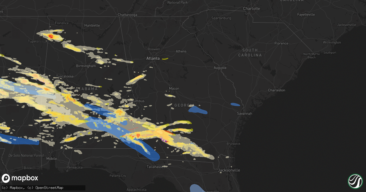
Hail Map in Georgia on June 14, 2023
Get this storm
June 14 map
$229
one time, instant access
Download today. No call, no setup
Keep the $229
Bought the map and want the full workflow? Apply the entire $229 to a subscription within 7 days. None of it is wasted.
Every map, not just this one
This buys you this map. Subscription and you get every map we run, in the markets you choose from a few cities to whole states to nationwide. Plus real-time alerts the moment a storm fires.
Contact data
Name, contact info, occupancy, even credit band for addresses in the footprint. You go from where it hit to who to call.
Become the source they trust
Unlimited branding weather history reports on demand. You already have the documented answer ready for the property owner, and you are the one who showed up with it.
Property data and RoofTrace estimates
Pull up any address you have got, its value and the exact code rules for that jurisdiction, straight from One Click Code. Then RoofTrace estimates the squares, pitch, and roof value, priced the way you price.
Storm reports in Georgia
Georgia
| Date | Description |
|---|---|
| 06/14/20236:49 PM CDT | Emergency manager reported a tree down on power lines near the intersection of sheftall and tietgen st. Time was estimated via radar data. |
| 06/14/20236:46 PM CDT | 2 trees down on sims brothers rd. |
| 06/14/20236:43 PM CDT | Report of a tree down with roof damage at the 100 block of henry ct. Extent of damage is unknown. |
| 06/14/20236:43 PM CDT | Tree down on red clay rd at us 301n. |
| 06/14/20236:43 PM CDT | Tree down at long st and sherry st in claxton. |
| 06/14/20236:42 PM CDT | Emergency manager reported a tree down along the 100 block of st matthews rd. Time was estimated via radar data. |
| 06/14/20236:41 PM CDT | Tree down on hugh brewton rd at hwy 280. |
| 06/14/20236:40 PM CDT | Multiple trees and power lines reported down near the intersection of pine st and nichols st. |
| 06/14/20236:39 PM CDT | Emergency manager reported a tree on power lines along hester rd near brittany ln. Time was estimated via radar data. |
| 06/14/20236:39 PM CDT | Tree down on hugh brewton rd north of bellville. |
| 06/14/20236:37 PM CDT | Tree down at 462 e c hunnicutt rd. |
| 06/14/20236:37 PM CDT | Power lines reported down on n main street at debbie drive. Time estimated from radar. |
| 06/14/20236:37 PM CDT | Tree down on n main st at debbie dr. |
| 06/14/20236:36 PM CDT | Tree and debris in roadway at kennedy bridge rd at hwy 129 s. |
| 06/14/20236:34 PM CDT | Emergency manager reported a tree down near little mccall rd and courthouse rd due to a possible tornado. Time was estimated via radar data. |
| 06/14/20236:34 PM CDT | Emergency manager reported a tree down along hwy 119 near forest rd possibly due to a tornado. Time was estimated via radar data. |
| 06/14/20236:30 PM CDT | Corrected report to change type to thunderstorm wind damage until survey can be completed. Possible tornado moving in vicinity of hwy 168 and cemetery rd damaging a hou |
| 06/14/20236:30 PM CDT | Emergency manager reports a tree down near the 300 block of 6th ave possibly due to a tornado. Time was estimated via radar data. |
| 06/14/20236:30 PM CDT | Possible tornado moving in vicinity of hwy 168 and cemetery rd damaging a house roof and a barn roof. Time of the event approximated via radar. |
| 06/14/20236:28 PM CDT | Emergency manager reported a tree down along hwy 17 near sunrise dr possibly due to a tornado. Time was estimated via radar data. |
| 06/14/20236:28 PM CDT | Emergency manager reported a tree down near 4th st ext and poplar st. Time was estimated via radar. |
| 06/14/20236:28 PM CDT | Emergency manager reported a tree down along the 500 block of w central blvd. Time was estimated via radar data. |
| 06/14/20236:28 PM CDT | Emergency manager relayed a report of a tree on top of a roof along the 500 block of magnolia st. Roof damage reported... But extent of damage is unknown. Time was esti |
| 06/14/20236:27 PM CDT | A national weather service damage survey team found that a tornado touchdown just northwest of guyton... Ga and travelled southeast across the northern portions of the |
| 06/14/20236:16 PM CDT | Report from mping: ping pong ball |
| 06/14/20236:16 PM CDT | Multiple trees down on s old river rd at shuman rd. |
| 06/14/20236:11 PM CDT | A tree was blown down on a house on ennis school rd. |
| 06/14/20236:11 PM CDT | Power lines reported down on stilson-leefield road at holloway road. Time estimated from radar. |
| 06/14/20236:10 PM CDT | A 911 call center reported a tree and power lines down along leefield rd near holloway rd. Time was estimated via radar data. |
| 06/14/20236:10 PM CDT | Multiple trees snapped off about 6 or 7 feet off the ground along brooklet-leefield rd. |
| 06/14/20236:08 PM CDT | A national weather service damage survey team found that a tornado briefly touched down near the intersection of clito road and brooklet-leefield road northeast of broo |
| 06/14/20236:07 PM CDT | Powerline down at intersection of ga highway 19 s and pinehill rd. |
| 06/14/20236:06 PM CDT | 911 call center reported a tree down near the intersection of clito rd and magnolia church rd. Time was estimated via radar data. |
| 06/14/20236:01 PM CDT | Tree down on beulah lane at emit grove rd. |
| 06/14/20236:00 PM CDT | Multiple trees downed in the vicinity of willacoochee. Timing approximated via radar. |
| 06/14/20236:00 PM CDT | Emergency manager reports power outage in willacoochee due to thunderstorm winds. |
| 06/14/20236:00 PM CDT | A local report indicates 1.75 inch wind near Adel |
| 06/14/20235:59 PM CDT | Power lines reported down along highway 67 at the garden district. Time estimated from radar. |
| 06/14/20235:58 PM CDT | A 911 call center reported a tree down along hwy 67 near stambuk lane. Time was estimated via radar data. |
| 06/14/20235:58 PM CDT | Tree reported down at highway 301 and randy lowery road. Time estimated from radar. |
| 06/14/20235:57 PM CDT | Softball sized hail reported by doerun city manager. |
| 06/14/20235:56 PM CDT | Tree down on a house at 175 n butler street. |
| 06/14/20235:55 PM CDT | Power lines reported down on n main street at debbie drive. Time estimated from radar. |
| 06/14/20235:54 PM CDT | A 911 call center reported a tree down near the intersection of s college st and w jones ave. Time was estimated via radar data. |
| 06/14/20235:45 PM CDT | Mesonet station uga09 camilla. |
| 06/14/20235:42 PM CDT | Powerline down on 100 block of lauren woods rd. |
| 06/14/20235:41 PM CDT | Power lines reported down along the 400 block of johnson street. Time estimated from radar. |
| 06/14/20235:41 PM CDT | A tree reported down at rocky ford rd and two chop rd. Time estimated from radar. |
| 06/14/20235:35 PM CDT | Report of a tornado at highway |
| 06/14/20235:35 PM CDT | Report of a tornado at highway 76 and weber. |
| 06/14/20235:32 PM CDT | Dozens of trees were downed along i-16 starting at the ga257 interchange... Closing the eastbound lane of i-16 for 20 minutes. No trees on structures but a few roads we |
| 06/14/20235:30 PM CDT | Tree limbs on sr 37 eastbound at powell dairy rd. All lanes closed. |
| 06/14/20235:15 PM CDT | Tree limbs on sr 50 at peavy rd. All lanes closed. |
| 06/14/20235:15 PM CDT | Large tree down across riverbend rd. Time is an estimate. |
| 06/14/20235:15 PM CDT | Multiple trees down along faith church rd. Time is an estimate. |
| 06/14/20235:05 PM CDT | Reports of numerous trees and powerlines down across terrell county. |
| 06/14/20235:00 PM CDT | Trees and powerlines down on home in the 1300 block of jp perry rd in northern colquitt county. |
| 06/14/20234:45 PM CDT | Reports of trees and powerlines down across randolph county. |
| 06/14/20234:43 PM CDT | Tree down along concord church rd near buck creek. |
| 06/14/20234:41 PM CDT | Tree down in a yard of the 600th block of hunter road. |
| 06/14/20234:40 PM CDT | Public reported a picture of a 3.75 inch hail stone next to a measuring tape. |
| 06/14/20234:37 PM CDT | Report from mping: half dollar |
| 06/14/20234:20 PM CDT | Report of golf ball sized hail south of irwinville. |
| 06/14/20234:20 PM CDT | Downed trees by the atkinson/coffee county line by the cross section of bent pine rd and us 441 south. |
| 06/14/20234:10 PM CDT | Trained spotter reports 1 inch hail. |
| 06/14/20234:00 PM CDT | Tree down in the roadway along rosemont church rd. |
| 06/14/20234:00 PM CDT | 2-3 inch hail stones falling on the albany marine corps logistic base. |
| 06/14/20234:00 PM CDT | Tree down on oak valley rd. |
| 06/14/20234:00 PM CDT | Report of golf ball sized hail in albany. |
| 06/14/20233:47 PM CDT | Tree down across intersection of old macon rd and pointe west dr. |
| 06/14/20233:45 PM CDT | Corrects time of previous hail report from 2 sse irwinville. Report of golf ball sized hail south of irwinville. |
| 06/14/20233:15 PM CDT | Tree down near the intersection of youngs mill rd and ringer rd. |
| 06/14/20233:08 PM CDT | Tree down in yard off of corinth rd. |
| 06/14/20233:00 PM CDT | Tree reported down near the intersection of tin bridges w hopson rd. |
| 06/14/20232:59 PM CDT | Tree down alongside poole rd. |
| 06/14/20232:57 PM CDT | Report from mping: quarter |
| 06/14/20232:49 PM CDT | Report from mping: quarter |
| 06/14/20232:45 PM CDT | Spotter reported a tornado west of highway 41 and north of ashburn. |
| 06/14/20232:20 PM CDT | Tree down on powerlines at intersection of hwy 155 and hwy 42. Lanes blocked. |
| 06/14/20232:14 PM CDT | Powerlines down on briarcliff rd. |
| 06/14/20232:11 PM CDT | Tree down at the intersection of oglesby bridge rd and hwy 212 sw. |
| 06/14/20232:11 PM CDT | Baseball sized hail reported on calvary road. |
| 06/14/20232:10 PM CDT | Henry county eoc reports winds up to 65 mph and several thousand without power throughout the county. |
| 06/14/20232:10 PM CDT | Report from mping: quarter |
| 06/14/20232:08 PM CDT | Corrects previous tstm wnd dmg report from 4 ene jenkinsburg. Tree down along buster brown rd. |
| 06/14/20232:08 PM CDT | Tree down on the road at the 4000 block of w mcintosh rd. |
| 06/14/20232:08 PM CDT | Tree down along wolf creek rd. |
| 06/14/20231:56 PM CDT | Tree down on house near the intersection of windsor pkwy and kingston ct. |
| 06/14/20231:54 PM CDT | Spotter reported tornado at this location. |
| 06/14/20231:46 PM CDT | Tree down along seavy st. |
| 06/14/20231:38 PM CDT | Tree down at the 600 block of seavy st. |
| 06/14/20231:37 PM CDT | Tree reported down on standing rock rd between hugh brown rd and toonerville rd. |
| 06/14/20231:36 PM CDT | Damage reported in the area of quail country road. |
| 06/14/20231:35 PM CDT | Social media picture of at least golf ball sized hail in grantville. |
| 06/14/20231:35 PM CDT | Tree down on donald lamb road. |
| 06/14/20231:35 PM CDT | 1 inch hail reported at intersection of seavy street and werner way. |
| 06/14/20231:30 PM CDT | Reports of trees down in lee county. |
| 06/14/20231:25 PM CDT | Public report with picture via social media of golf ball sized hail in hoganville. |
| 06/14/20231:25 PM CDT | Quarter sized hail reported by emergency manager in hogansville. |
| 06/14/20231:25 PM CDT | Approximately a dozen trees down across roadways within ellaville city limits. |
| 06/14/20231:19 PM CDT | Tree reported down near the intersection of w grantville rd and arnold st. |
| 06/14/20231:15 PM CDT | Quarter sized hail reported on hammett road near hwy 54. |
| 06/14/20231:15 PM CDT | Corrects previous tstm wnd dmg report from 2 wnw hogansville. 20+ reports of trees down along and near roads in the area of hwy 54 west of hogansville. |
| 06/14/20231:15 PM CDT | 1 inch hail reported by public near hwy 29 in grantville. |
| 06/14/20231:15 PM CDT | Tree down on hammett road near highway 54. |
| 06/14/20231:08 PM CDT | Tree down along buster brown rd. |
| 06/14/20231:05 PM CDT | A local report indicates 2.50 inch wind near Blakely |
| 06/14/20231:05 PM CDT | Hail estimated around golf ball size in blakely. |
| 06/14/202312:43 PM CDT | Corrects previous tstm wnd dmg report from 2 s concord. Tree down along concord church rd near buck creek. |
| 06/14/202312:22 PM CDT | Tree down on the road near the intersection of nutt dr and hunter rd. |
| 06/14/202312:20 PM CDT | Tree downed across chattsworth road near technology parkway. |
| 06/14/202310:16 AM CDT | Tree down at hwy 280 and ken white road. |
| 06/14/20239:23 AM CDT | Claxton sheriff reported 1 tree down on stewart st in claxton. |
| 06/14/20238:28 AM CDT | Tree down on i-16 eb between mile marker 69 and mile marker 70. |
| 06/14/20238:13 AM CDT | Multiple trees down across road at hwy 441 and old prison camp road. |
| 06/14/20238:10 AM CDT | Corrects previous tstm wnd dmg report from 3 sw helena. Tree down at hwy 280 and ken white road. |
| 06/14/20238:03 AM CDT | Downed trees in the area east off of highway 158 east of chatterton church rd due to winds. |
| 06/14/20237:52 AM CDT | Power lines down and transformer blown on woodleaf rd n. |
| 06/14/20237:47 AM CDT | Tree down on jim ross rd near the intersection with fair haven rd. |
| 06/14/20237:45 AM CDT | Tree down on jerry farmer rd near intersection with abbeville hwy. |
| 06/14/20237:44 AM CDT | Tree and power lines down on abbeville highway near piney grove church. |
| 06/14/20237:30 AM CDT | Tree down on hwy 41 near brantley road. |
| 06/14/20235:25 AM CDT | Large tree limbs were down on highway 253 near mile post 2.3 blocking the road. |
| 06/14/20235:00 AM CDT | Large tree limbs were down on highway 273 at highway 370 blocking the road. |
| 06/13/20239:39 PM CDT | Tree down on power line near the intersection of jodeco way and noahs ark rd. |
| 06/13/20238:50 PM CDT | 4 inch diameter tree branches down with numerous smaller branches down as well. |
| 06/13/20238:36 PM CDT | Trees and power lines down in brooks county. |
| 06/13/20238:17 PM CDT | Powerline down on the 400 block of turkey creek circle. |
| 06/13/20238:15 PM CDT | Reported power lines down... Trees down |
| 06/13/20238:13 PM CDT | Trees and power lines down in thomas county. |
| 06/13/20237:48 PM CDT | 1 tree down on old seabrook school rd. |
| 06/13/20237:40 PM CDT | Mesonet station tt665 bainbridge near the decatur county airport. |
| 06/13/20237:40 PM CDT | Trees down along river road. |
| 06/13/20237:39 PM CDT | City of bainbridge boat basin weatherstem gusted to 71 mph. |
| 06/13/20237:35 PM CDT | Awos station kbge bainbridge. |
| 06/13/20237:30 PM CDT | Several trees down on lewis frasier rd and slade rd. |
| 06/13/20237:27 PM CDT | 20+ reports of trees down along and near roads in the area of hwy 54 west of hogansville. |
| 06/13/20237:25 PM CDT | Trees and power lines reported down across miller county. |
| 06/13/20237:19 PM CDT | 1 tree down on griffin rd at arnall dr. |
| 06/13/20237:19 PM CDT | Ambient mesonet observation. 58mph gust. |
| 06/13/20237:15 PM CDT | Power pole reported inside a home in sw lowndes county. |
| 06/13/20237:10 PM CDT | Tree down in road at hwy 129 at old hwy 250. |
| 06/13/20237:05 PM CDT | Trees and powerlines reported down across lowndes county. |
| 06/13/20237:00 PM CDT | Got report from a storm spotter and confirmed by emer. Mgr of damage to a carport and a porch at a home located off of berry patch rd... Nw of homerville ap. Time is es |
| 06/13/20237:00 PM CDT | Report from mping: 3-inch tree limbs broken; power poles broken. |
All States Impacted by Hail Map on June 14, 2023
Cities Impacted by Hail Map on June 14, 2023
- Claremore, OK
- Pryor, OK
- Ward, AR
- Lonoke, AR
- Austin, AR
- Carlisle, AR
- Hickory Plains, AR
- Des Arc, AR
- Hazen, AR
- Biscoe, AR
- Salina, OK
- Locust Grove, OK
- Rose, OK
- Tahlequah, OK
- Oaks, OK
- Twin Oaks, OK
- Kansas, OK
- Colcord, OK
- Eastman, GA
- Cadwell, GA
- Chauncey, GA
- McRae Helena, GA
- Dublin, GA
- Alamo, GA
- Rentz, GA
- Glenwood, GA
- Proctor, OK
- Westville, OK
- Watts, OK
- Stilwell, OK
- Mount Vernon, GA
- Uvalda, GA
- Ailey, GA
- Lincoln, AR
- Summers, AR
- Canehill, AR
- Chelsea, OK
- Siloam Springs, AR
- Fayetteville, AR
- Prairie Grove, AR
- Farmington, AR
- Evansville, AR
- Morrow, AR
- West Fork, AR
- Vidalia, GA
- Winslow, AR
- Marietta, OK
- Kingston, OK
- Lebanon, OK
- Clarksdale, MS
- Alligator, MS
- Duncan, MS
- Golden, MS
- Belmont, MS
- Dennis, MS
- New Site, MS
- Red Bay, AL
- Vina, AL
- Tutwiler, MS
- Hodges, AL
- Russellville, AL
- Phil Campbell, AL
- Spruce Pine, AL
- Sumner, MS
- Charleston, MS
- Colbert, OK
- Calera, OK
- Hendrix, OK
- Durant, OK
- Bokchito, OK
- Hackleburg, AL
- Bear Creek, AL
- Haleyville, AL
- Cascilla, MS
- Abbeville, AL
- Morris, GA
- Grenada, MS
- Scobey, MS
- Ivanhoe, TX
- Telephone, TX
- Dodd City, TX
- Windom, TX
- Honey Grove, TX
- Bonham, TX
- Petty, TX
- Shorterville, AL
- Coffeeville, MS
- Fort Gaines, GA
- Clayton, AL
- Roxton, TX
- Brookston, TX
- Paris, TX
- Bogata, TX
- Deport, TX
- Pattonville, TX
- Clarksville, TX
- Mount Pleasant, TX
- Talco, TX
- Detroit, TX
- Blossom, TX
- Bagwell, TX
- Annona, TX
- Cookville, TX
- Avery, TX
- De Kalb, TX
- Carrollton, GA
- Waco, GA
- Blakely, GA
- Eufaula, AL
- Simms, TX
- Omaha, TX
- Georgetown, GA
- Naples, TX
- New Boston, TX
- Bluffton, GA
- Alton, MO
- Couch, MO
- Gatewood, MO
- Doniphan, MO
- Columbia, AL
- Marietta, TX
- Douglassville, TX
- Hughes Springs, TX
- Linden, TX
- Atlanta, TX
- Maud, TX
- Queen City, TX
- Texarkana, TX
- Bloomburg, TX
- Doddridge, AR
- Brooksville, MS
- Macon, MS
- Double Springs, AL
- Lynn, AL
- Nauvoo, AL
- Hogansville, GA
- Lagrange, GA
- Franklin, GA
- Arley, AL
- Houston, AL
- Jasper, AL
- Oneonta, AL
- Altoona, AL
- Grantville, GA
- Damascus, GA
- Arlington, GA
- Leary, GA
- Morgan, GA
- Newton, GA
- Albany, GA
- Ackerman, MS
- Beebe, AR
- Marietta, MS
- Sumner, TX
- Springville, AL
- Chouteau, OK
- Montgomery, AL
- Pike Road, AL
- Catoosa, OK
- Mount Judea, AR
- Pelsor, AR
- Phenix City, AL
- Smiths Station, AL
- Salem, AL
- Overbrook, OK
- Cusseta, AL
- Valley, AL
- De Valls Bluff, AR
- Opelika, AL
- Thayer, MO
- Troy, AL
- Deer, AR
- Marked Tree, AR
- Banks, AL
- Louisville, AL
- Headland, AL
- Conway, AR
- Elko, GA
- Unadilla, GA
- Holcomb, MS
- Cherokee, AL
- Eupora, MS
- Lyon, MS
- Crumrod, AR
- Lambert, MS
- Mellwood, AR
- Drew, MS
- Pinson, AL
- Gore Springs, MS
- Duck Hill, MS
- Midland City, AL
- Tallassee, AL
- Notasulga, AL
- Dadeville, AL
- Camp Hill, AL
- Waverly, AL
- Auburn, AL
- Hanceville, AL
- Madill, OK
- Shellman, GA
- Cleveland, AL
- Cullman, AL
- Hayden, AL
- Blountsville, AL
- Mathiston, MS
- Bellefontaine, MS
- Cuthbert, GA
- Tuscumbia, AL
- Harrell, AR
- Camden, AR
- Hampton, AR
- Cartwright, OK
- Remlap, AL
- Newville, AL
- Lanett, AL
- Calhoun City, MS
- Bowdon, GA
- Heflin, AL
- Muscadine, AL
- Fruithurst, AL
- Ranburne, AL
- Anniston, AL
- Vance, MS
- Fulton, MS
- Baldwyn, MS
- Clopton, AL
- Mead, OK
- Elaine, AR
- De Witt, AR
- Ethel, AR
- Casscoe, AR
- Roe, AR
- Stuttgart, AR
- Sturgis, MS
- Ozark, AL
- Dawson, GA
- Newton, AL
- Dothan, AL
- Fort Rucker, AL
- Scott, AR
- Koshkonong, MO
- Mantachie, MS
- Tremont, MS
- Booneville, MS
- Leighton, AL
- Walthall, MS
- Chester, AR
- Spavinaw, OK
- Eucha, OK
- Jay, OK
- Adair, OK
- Five Points, AL
- Bennington, OK
- Sulphur Bluff, TX
- Ravenna, TX
- Pottsboro, TX
- Aliceville, AL
- Bivins, TX
- Rodessa, LA
- Vivian, LA
- Hosston, LA
- Ida, LA
- Plain Dealing, LA
- Moreland, GA
- Bradley, AR
- Fouke, AR
- Springhill, LA
- Sarepta, LA
- Cotton Valley, LA
- Crane Hill, AL
- Bremen, AL
- Benton, LA
- Shongaloo, LA
- Minden, LA
- Eutaw, AL
- Boligee, AL
- Haynesville, LA
- Homer, LA
- Louisville, MS
- Durant, MS
- West, MS
- Sallis, MS
- Kosciusko, MS
- Conyers, GA
- Loganville, GA
- Oxford, GA
- Covington, GA
- Weogufka, AL
- Rockford, AL
- Pell City, AL
- Odenville, AL
- Riverside, AL
- Lincoln, AL
- Ragland, AL
- Hollandale, MS
- Baconton, GA
- Valdosta, GA
- Arcadia, LA
- Naylor, GA
- Stockton, GA
- Leesburg, GA
- Oakfield, GA
- Warwick, GA
- Ashburn, GA
- Sylvester, GA
- Shuqualak, MS
- Preston, MS
- Greensboro, AL
- Newbern, AL
- Uniontown, AL
- Marion Junction, AL
- Marion, AL
- Athens, LA
- Gibsland, LA
- Millbrook, AL
- Simsboro, LA
- Dubach, LA
- Scooba, MS
- Belzoni, MS
- Lexington, MS
- Pickens, MS
- Silver City, MS
- Tchula, MS
- Isola, MS
- Goodman, MS
- Quitman, LA
- Ruston, LA
- Fitzgerald, GA
- Abbeville, GA
- Rochelle, GA
- Rebecca, GA
- Selma, AL
- Emelle, AL
- Bienville, LA
- Grambling, LA
- Chatham, LA
- Eros, LA
- Rhine, GA
- Choudrant, LA
- Chula, GA
- Tifton, GA
- Sycamore, GA
- Ocilla, GA
- Jonesboro, LA
- Indianola, MS
- Leland, MS
- Inverness, MS
- Greenville, MS
- Itta Bena, MS
- Yazoo City, MS
- Cruger, MS
- Sardis, AL
- Epes, AL
- Gainesville, AL
- Grayson, LA
- Columbia, LA
- Benton, MS
- West Monroe, LA
- Vaughan, MS
- Camden, MS
- Philadelphia, MS
- Carthage, MS
- Union, MS
- McCool, MS
- Noxapater, MS
- Ethel, MS
- Kelly, LA
- Wray, GA
- Olla, LA
- Winnsboro, LA
- Sawyerville, AL
- Collinsville, MS
- De Kalb, MS
- Daleville, MS
- Harrisonburg, LA
- Enterprise, LA
- Fort Necessity, LA
- Forkland, AL
- Waldron, AR
- Ambrose, GA
- Douglas, GA
- Porterville, MS
- Lauderdale, MS
- York, AL
- Livingston, AL
- Jacksonville, GA
- Broxton, GA
- Sicily Island, LA
- Wisner, LA
- Gilbert, LA
- Sikes, LA
- Clayton, LA
- Ferriday, LA
- Saint Joseph, LA
- Poulan, GA
- Sumner, GA
- Ty Ty, GA
- Harvey, AR
- Hot Springs Village, AR
- Hot Springs National Park, AR
- Lonsdale, AR
- Waterproof, LA
- Hayneville, AL
- Autaugaville, AL
- Lowndesboro, AL
- Tyler, AL
- Hope Hull, AL
- Letohatchee, AL
- Ramer, AL
- Lapine, AL
- Mathews, AL
- Fitzpatrick, AL
- Grady, AL
- Union Springs, AL
- Malvern, AR
- Benton, AR
- Lorman, MS
- Doerun, GA
- Plainview, AR
- Natchez, MS
- Fayette, MS
- Port Gibson, MS
- Midway, AL
- Scurry, TX
- Doyline, LA
- Forest, MS
- Lake, MS
- Morton, MS
- Dubberly, LA
- Vicksburg, MS
- Kilgore, TX
- Sweet Water, AL
- Meridian, MS
- Pelahatchie, MS
- Rayville, LA
- Tyler, TX
- Newton, MS
- Catherine, AL
- Waskom, TX
- Orrville, AL
- Shreveport, LA
- Ward, AL
- Clinton, MS
- Lisman, AL
- Winona, TX
- Mabank, TX
- Greenwood, LA
- Ben Wheeler, TX
- Delhi, LA
- Elm Grove, LA
- Hickory, MS
- Eustace, TX
- Enterprise, MS
- Bossier City, LA
- Edwards, MS
- Monroe, LA
- Safford, AL
- Pennington, AL
- Brandon, MS
- Haughton, LA
- Jachin, AL
- Chunky, MS
- Linden, AL
- Lawrence, MS
- Thomaston, AL
- Longview, TX
- Ennis, TX
- Jackson, MS
- Marshall, TX
- Tallulah, LA
- Hallsville, TX
- Bolton, MS
- Kemp, TX
- Alberta, AL
- Canton, TX
- Flowood, MS
- Heflin, LA
- Calhoun, LA
- Midlothian, TX
- Parks, AR
- Traskwood, AR
- Silver Creek, MS
- Prentiss, MS
- Newhebron, MS
- Wills Point, TX
- Edgewood, TX
- Roxie, MS
- Sheridan, AR
- Moultrie, GA
- Norman Park, GA
- Omega, GA
- Sims, AR
- Story, AR
- Mount Ida, AR
- Bauxite, AR
- Waxahachie, TX
- Red Oak, TX
- Minter, AL
- Forest Home, AL
- Fort Deposit, AL
- Danville, AR
- Ola, AR
- Grand Saline, TX
- Fruitvale, TX
- Royal, AR
- Brookhaven, MS
- Union Church, MS
- Wesson, MS
- McCall Creek, MS
- Meadville, MS
- Pattison, MS
- Hazlehurst, MS
- Jessieville, AR
- Palmer, TX
- Georgiana, AL
- Honoraville, AL
- Greenville, AL
- Highland Home, AL
- Goshen, AL
- Luverne, AL
- Rutledge, AL
- Glenwood, AL
- Brantley, AL
- Dozier, AL
- Pearcy, AR
- Van, TX
- Camilla, GA
- Sale City, GA
- Hartsfield, GA
- Mountain Pine, AR
- Lindale, TX
- Sparks, GA
- Adel, GA
- Nashville, GA
- Brundidge, AL
- Elba, AL
- Ariton, AL
- Clio, AL
- Enterprise, AL
- Jack, AL
- New Brockton, AL
- Collins, MS
- Bonnerdale, AR
- Rice, TX
- Chatfield, TX
- Pittsview, AL
- Perry, GA
- Montezuma, GA
- Lafayette, AL
- Marion, LA
- Rosston, AR
- Rainbow City, AL
- Gadsden, AL
- Moody Afb, GA
- Lakeland, GA
- Chidester, AR
- Stephens, AR
- Shepherd, MT
- Bastrop, LA
- Goodwater, AL
- Bellamy, AL
- Jemison, AL
- Clanton, AL
- Thorsby, AL
- Holly Pond, AL
- Horton, AL
- Camden, AL
- Starkville, MS
- Hamilton, AL
- Prattville, AL
- Richland, GA
- Lumpkin, GA
- Weston, GA
- Parrott, GA
- Lake Park, GA
- Faunsdale, AL
- Dixie, GA
- Pavo, GA
- Little Rock, AR
- Talladega, AL
- Bryant, AR
- Lizella, GA
- Knoxville, GA
- Baileyton, AL
- Lenox, GA
- Luthersville, GA
- Lake Village, AR
- Monticello, AR
- Fountain Hill, AR
- Hamburg, AR
- Dermott, AR
- Montrose, AR
- Hermitage, AR
- Wilmar, AR
- Ashville, AL
- Hahira, GA
- Oxford, AL
- Munford, AL
- Sharpsburg, GA
- Millerville, AL
- Ashland, AL
- Bonaire, GA
- Fort Valley, GA
- Centerville, GA
- Byron, GA
- Warner Robins, GA
- Buena Vista, GA
- Edison, GA
- Taylor, AR
- Magnolia, AR
- Lewisville, AR
- Emerson, AR
- Quitman, GA
- Morven, GA
- Hope, AR
- Fulton, AR
- Pine Apple, AL
- Epps, LA
- Fayetteville, GA
- Enigma, GA
- Wellington, AL
- Jacksonville, AL
- Ohatchee, AL
- Piedmont, AL
- Jacksonville, FL
- Seale, AL
- Fort Mitchell, AL
- Fort Benning, GA
- Newnan, GA
- Parma, MO
- Coosada, AL
- Gallion, AL
- Gallant, AL
- Steele, AL
- Guntersville, AL
- Ozan, AR
- Lakehurst, NJ
- Moorhead, MS
- Mansfield, TX
- Attalla, AL
- Addison, AL
- Logan, AL
- Trafford, AL
- Warrior, AL
- Eastaboga, AL
- Locust Fork, AL
- Moody, AL
- Prescott, AR
- Alapaha, GA
- Demopolis, AL
- Ray City, GA
- Crawford, MS
- Greenville, GA
- Senoia, GA
- Eclectic, AL
- Wetumpka, AL
- West Point, GA
- Gay, GA
- Fort Pierce, FL
- Jonesboro, GA
- Hamilton, GA
- Shiloh, GA
- Hartford, AR
- Oak Ridge, LA
- Sondheimer, LA
- Boaz, AL
- Hensley, AR
- Barney, GA
- Tuskegee, AL
- Shorter, AL
- Weir, MS
- Sibley, LA
- Coleman, GA
- Hurtsboro, AL
- Hardaway, AL
- Ashford, AL
- Arabi, GA
- Willacoochee, GA
- Hatchechubbee, AL
- Cecil, AL
- Deatsville, AL
- Norman, AR
- White Hall, AR
- Jefferson, AR
- Pine Bluff, AR
- Sherrill, AR
- Brooklet, GA
- Guyton, GA
- Rincon, GA
- Springfield, GA
- Altheimer, AR
- Redfield, AR
- Powell, TX
- Kerens, TX
- Raymond, MS
- Dardanelle, AR
- Casa, AR
- Morrilton, AR
- Pottsville, AR
- Atkins, AR
- Skipperville, AL
- Webb, AL
- Cowarts, AL
- Solgohachia, AR
- Springfield, AR
- Bogue Chitto, MS
- Sontag, MS
- Ruth, MS
- Monticello, MS
- Jayess, MS
- Oak Vale, MS
- Columbia, MS
- Kokomo, MS
- Carson, MS
- Foxworth, MS
- Sumrall, MS
- Lumberton, MS
- Bassfield, MS
- Hattiesburg, MS
- Damascus, AR
- Hattieville, AR
- Center Ridge, AR
- Colquitt, GA
- Jakin, GA
- Pansey, AL
- Donalsonville, GA
- Gordon, AL
- Bascom, FL
- Cottonwood, AL
- Donaldson, AR
- Leola, AR
- Poyen, AR
- Grapevine, AR
- Rison, AR
- Prattsville, AR
- Brinson, GA
- Greenbrier, AR
- Quitman, AR
- Iron City, GA
- Whigham, GA
- Cairo, GA
- Climax, GA
- Bainbridge, GA
- Quincy, FL
- Attapulgus, GA
- Richton, MS
- Petal, MS
- Beaumont, MS
- Purvis, MS
- Leakesville, MS
- McLain, MS
- New Augusta, MS
- Neely, MS
- Pearl, MS
- Richland, MS
- Ridgeland, MS
- Gould, AR
- Gillett, AR
- Tichnor, AR
- Watson, AR
- Gunnison, MS
- Snow Lake, AR
- Timbo, AR
- Onia, AR
- Leslie, AR
- Fifty Six, AR
- Maynard, AR
- Success, AR
- Naylor, MO
- Corning, AR
- Star City, AR
- Grady, AR
- Tillar, AR
- Dumas, AR
- Pickens, AR
- Winchester, AR
- Knobel, AR
- Piggott, AR
- Rector, AR
- Marmaduke, AR
- Lafe, AR
- Thomasville, GA
- Havana, FL
- Tallahassee, FL
- Lucedale, MS
- State Line, MS
- Mena, AR
- Caddo Gap, AR
- Glenwood, AR
- Melbourne, AR
- Mountain View, AR
- McGehee, AR
- Banks, AR
- Warren, AR
- Amity, AR
- Arkansas City, AR
- Rohwer, AR
- Benoit, MS
- Kennett, MO
- Senath, MO
- Paragould, AR
- Brockwell, AR
- Guion, AR
- Violet Hill, AR
- Sage, AR
- Horseshoe Bend, AR
- Franklin, AR
- Evening Shade, AR
- Ash Flat, AR
- Arkadelphia, AR
- Madison, MS
- Hardy, AR
- Thornton, AR
- Canton, MS
- Decatur, MS
- Fordyce, AR
- New Edinburg, AR
- Springdale, AR
- Elkins, AR
- Hindsville, AR
- Wesley, AR
- Huntsville, AR
- Witter, AR
- Magnolia, AL
- Mashpee, MA
- Sandwich, MA
- Boyes, MT
- Livermore, CO
- Carthage, AR
- Grove Hill, AL
- Meredith, NH
- Center Harbor, NH
- New Hampton, NH
- Dixons Mills, AL
- Butler, AL
- Black, AL
- Hartford, AL
- Beech Grove, AR
- Walnut Ridge, AR
- Lowell, AR
- Cave Springs, AR
- Seminary, MS
- Ellisville, MS
- Lindsay, MT
- Satartia, MS
- Redwood, MS
- Atmore, AL
- Little River, AL
- Deer Park, AL
- Fruitdale, AL
- Cuttyhunk, MA
- Woods Hole, MA
- East Falmouth, MA
- Buzzards Bay, MA
- Falmouth, MA
- Jones, AL
- Repton, AL
- Range, AL
- Brewton, AL
- Clinton, AR
- Dennard, AR
- Delaplaine, AR
- Tie Siding, WY
- Du Pont, GA
- Fargo, GA
- Circle, MT
- Bismarck, AR
- Richey, MT
- Shaw, MS
- Toomsuba, MS
- North Palm Beach, FL
- Coolidge, GA
- Saint Paul, AR
- Boston, GA
- Cheyenne, WY
- Waynesboro, MS
- Rogers, AR
- Toxey, AL
- Silas, AL
- Pine Hill, AL
- Shubuta, MS
- Thomasville, AL
- Coffeeville, AL
- Lower Peach Tree, AL
- Gilbertown, AL
- Mount Olive, MS
- Town Creek, AL
- Frankville, AL
- Jackson, AL
- Millry, AL
- Guy, AR
- Needham, AL
- Dickinson, AL
- Coy, AL
- Whatley, AL
- Little Compton, RI
- New Bedford, MA
- North Dartmouth, MA
- South Dartmouth, MA
- Rochester, MA
- Westport, MA
- Acushnet, MA
- Daleville, AL
- Andalusia, AL
- Red Level, AL
- Chancellor, AL
- Stockton, AL
- Mount Vernon, AL
- Citronelle, AL
- McIntosh, AL
- Vinegar Bend, AL
- Soperton, GA
- Homerville, GA
- Witts Springs, AR
- Hilliard, FL
- Biggers, AR
- Warm Springs, AR
- Pollard, AR
- Arbyrd, MO
- Hornersville, MO
- Cardwell, MO
- Peach Orchard, AR
- Neelyville, MO
- Wagarville, AL
- Chatom, AL
- Tibbie, AL
- Palm Beach Gardens, FL
- Venus, TX
- Yorktown, AR
- Opp, AL
- Loxahatchee, FL
- Pinola, MS
- Barry, TX
- Blooming Grove, TX
- Greenwood, MS
- Carrollton, MS
- Eudora, AR
- Evergreen, AL
- Monticello, FL
- McKenzie, AL
- Moulton, AL
- Marshall, AR
- Statenville, GA
- Newellton, LA
- Perdido, AL
- Bay Minette, AL
- Lame Deer, MT
- North Little Rock, AR
- Alvarado, TX
- Mount Hope, AL
- West Yarmouth, MA
- South Yarmouth, MA
- Belcher, LA
- Mize, MS
- Taylorsville, MS
- Pettigrew, AR
- Doddsville, MS
- Cuba, AL
- Lamont, FL
- Castleberry, AL
- Terrell, TX
- Hermanville, MS
- Mendenhall, MS
- Magee, MS
- Sunflower, AL
- Ponca, AR
- Kingston, AR
- Shirley, AR
- Kingsland, GA
- Yulee, FL
- Campbell, AL
- Melvin, AL
- Tishomingo, MS
- Roberta, GA
- Pinetta, FL
- Sidon, MS
- McDavid, FL
- Saint Stephens, AL
- Saint Charles, AR
- Pocahontas, AR
- Ellenton, GA
- Funston, GA
- Berlin, GA
- Pencil Bluff, AR
- Saint George, GA
- Little Rock, MS
- Marion, MS
- Quitman, MS
- Beatrice, AL
- High Springs, FL
- Branford, FL
- Alachua, FL
- Williston, FL
- Newberry, FL
- Gainesville, FL
- Bell, FL
- Archer, FL
- Bronson, FL
- Chiefland, FL
- Old Town, FL
- Trenton, FL
- Micanopy, FL
- Meriden, WY
- Otter, MT
- Scotland, AR
- Scottsbluff, NE
- Arlington, AL
- Tilly, AR
- Hector, AR
- Walnut Grove, MS
- Flora, MS
- Lena, MS
- Byram, MS
- Bentonia, MS
- Conehatta, MS
- Bailey, MS
- Maben, MS
- Jay, FL
- Milton, FL
- Century, FL
- Eastham, MA
- Stewart, MS
- Kilmichael, MS
- French Camp, MS
- Enid, MS
- Flomaton, AL
- El Dorado, AR
- Schlater, MS
- Philipp, MS
- Sunflower, MS
- Vredenburgh, AL
- Portland, AR
- Bearden, AR
- Peterman, AL
- Sebastopol, MS
- Bonita, LA
- Uriah, AL
- Frisco City, AL
- Lake Providence, LA
- Transylvania, LA
- Mayersville, MS
- Rolling Fork, MS
- Valley Park, MS
- Titus, AL
- Gordo, AL
- Vaiden, MS
- Lenox, AL
- Brent, AL
- Knoxville, AL
- Louise, MS
- Spearsville, LA
- Jersey, AR
- Strong, AR
- Anguilla, MS
- Fosters, AL
- Ralph, AL
- Moundville, AL
- Akron, AL
- Danville, AL
- Decatur, AL
- Centreville, AL
- Huttig, AR
- Crossett, AR
- Mer Rouge, LA
- Buhl, AL
- Lawley, AL
- Mount Holly, AR
- Junction City, AR
- Monroeville, AL
- Carrollton, AL
- Booth, AL
- Tinsley, MS
- Elmore, AL
- Marbury, AL
- Parkdale, AR
- Billingsley, AL
- Saraland, AL
- Verbena, AL
- Tuscaloosa, AL
- Bishop, TX
- Oak Grove, LA
- Pioneer, LA
- Holly Grove, AR
- Marvell, AR
- Plantersville, AL


