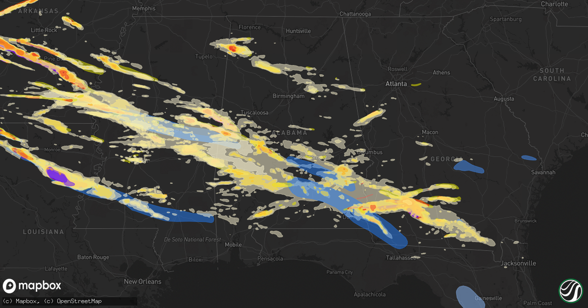
Hail Map in Alabama on June 14, 2023
Get this storm
June 14 map
$229
one time, instant access
Download today. No call, no setup
Keep the $229
Bought the map and want the full workflow? Apply the entire $229 to a subscription within 7 days. None of it is wasted.
Every map, not just this one
This buys you this map. Subscription and you get every map we run, in the markets you choose from a few cities to whole states to nationwide. Plus real-time alerts the moment a storm fires.
Contact data
Name, contact info, occupancy, even credit band for addresses in the footprint. You go from where it hit to who to call.
Become the source they trust
Unlimited branding weather history reports on demand. You already have the documented answer ready for the property owner, and you are the one who showed up with it.
Property data and RoofTrace estimates
Pull up any address you have got, its value and the exact code rules for that jurisdiction, straight from One Click Code. Then RoofTrace estimates the squares, pitch, and roof value, priced the way you price.
Storm reports in Alabama
Alabama
| Date | Description |
|---|---|
| 06/14/20236:54 PM CDT | Trees and powerlines reported down across geneva county. |
| 06/14/20236:45 PM CDT | Several trees and power lines down across the county. |
| 06/14/20236:43 PM CDT | Asos station kdhn dothan reported a wind gust of 66 mph. |
| 06/14/20236:30 PM CDT | Numerous trees and power lines down acro |
| 06/14/20236:30 PM CDT | Numerous trees and power lines down across dale county. |
| 06/14/20236:30 PM CDT | Trees reported down across henry county. |
| 06/14/20236:28 PM CDT | Numerous trees and power lines down across coffee county. |
| 06/14/20236:26 PM CDT | 911 call center reports numerous trees down around the river falls area and other surrounding locations. Time using radar. |
| 06/14/20236:22 PM CDT | A local report indicates 70 MPH wind near 1 ESE Hwy 231 Pea River |
| 06/14/20236:22 PM CDT | A few trees were blown down onto the roadway near lury walker road and spivey pitt road. |
| 06/14/20236:18 PM CDT | Numerous reports of widespread tree and power line damage from from river falls up through dozier between the hours of 6-7pm. Em and 911 center reports. Time using rada |
| 06/14/20236:15 PM CDT | A few trees were blown down. |
| 06/14/20236:05 PM CDT | Trees blocking both lanes near allan rd & trogdon ln in grove hill. Also multiple power outages in area. Time estimated using radar. |
| 06/14/20236:02 PM CDT | Bm relayed report of quarter hail in evergreen near i-65 corridor. |
| 06/14/20236:00 PM CDT | Multiple trees and power lines blown down in the southern part of the county. |
| 06/14/20235:51 PM CDT | Photo provided by em of very large healthy tree snapped partially on top of a house on s grove ave. Time estimated on radar. Em also reports widespread damage across th |
| 06/14/20235:50 PM CDT | Algo reports storm debris on al 10 @ n goshen rd blocking traffic in all directions. |
| 06/14/20235:48 PM CDT | Algo reports storm debris blocking roads in both directions @ 3rd ave. Time using radar. |
| 06/14/20235:40 PM CDT | A local report indicates 68 MPH wind near 1 WNW Cecil |
| 06/14/20235:38 PM CDT | Algo reports storm debris on us331 blocking both directions near sardis rd. Time using radar. |
| 06/14/20235:36 PM CDT | Police chief reported via social media that there are numerous trees down across greenville and many more within butler county outside of greenville limits. Photo provi |
| 06/14/20235:29 PM CDT | Report of tree blocking both lanes of tallahatta springs rd around the 10000 block. Time estimated using radar. |
| 06/14/20235:26 PM CDT | Report of tree down blocking road around 5000 block of tallahatta springs rd. Time estimated from radar. |
| 06/14/20235:25 PM CDT | Trees down on golson road in fort deposit per social media. Widespread power outages reported. |
| 06/14/20235:22 PM CDT | A local report indicates 60 MPH wind near Dannelly Field |
| 06/14/20234:50 PM CDT | Several trees were blown down in valley grand. |
| 06/14/20234:50 PM CDT | Trees were blown down onto power lines on cr 49. |
| 06/14/20234:40 PM CDT | Numerous trees were blown down across north and northeast pike county. |
| 06/14/20234:38 PM CDT | Several trees were blown down in southern bullock county. |
| 06/14/20234:35 PM CDT | Trees were blown down. |
| 06/14/20234:30 PM CDT | Trees were blown down in thomaston. |
| 06/14/20234:22 PM CDT | Numerous trees reported down on meriwether trail. |
| 06/14/20234:22 PM CDT | Numerous trees were blown down across southern montgomery county. |
| 06/14/20234:18 PM CDT | Numerous trees downed between downtown eufaula and the airport. |
| 06/14/20234:16 PM CDT | A few trees were uprooted and several large branches down. |
| 06/14/20234:15 PM CDT | Corrects previous hail report from coatopa. Several trees were blown down near al 28. |
| 06/14/20234:15 PM CDT | Several trees were blown down near al 28. |
| 06/14/20234:13 PM CDT | Numerous trees were blown down across central montgomery county. |
| 06/14/20234:12 PM CDT | Trees blown down around jefferson. |
| 06/14/20234:11 PM CDT | Several trees were blown down on hobbie road. |
| 06/14/20234:04 PM CDT | Trees were blown down on wasden road. |
| 06/14/20234:01 PM CDT | Trees down near highway 165 and terminal rd. |
| 06/14/20233:56 PM CDT | Several trees were blown down in southeastern bullock county. |
| 06/14/20233:48 PM CDT | Report from mping: quarter |
| 06/14/20233:35 PM CDT | A few trees were blown down near david drive. |
| 06/14/20233:30 PM CDT | A local report indicates 1.00 inch wind near Selma |
| 06/14/20233:20 PM CDT | Several trees were blown down along al 116. |
| 06/14/20233:20 PM CDT | A local report indicates 1.75 inch wind near 5 W Gainesville |
| 06/14/20233:18 PM CDT | Several trees were blown down and blocking us 80. |
| 06/14/20233:10 PM CDT | A local report indicates 72 MPH wind near 1 WNW Cecil |
| 06/14/20233:06 PM CDT | Several trees were blown down around montgomery. |
| 06/14/20233:03 PM CDT | Report from mping: quarter |
| 06/14/20232:56 PM CDT | Social media report of a tree on a house. |
| 06/14/20232:55 PM CDT | Trees down across road near beauregard. Time estimated by radar. |
| 06/14/20232:55 PM CDT | Trees down across sandhill rd. Time estimated by radar. |
| 06/14/20232:48 PM CDT | A local report indicates 2.00 inch wind near 5 NW Vaiden |
| 06/14/20232:30 PM CDT | Quarter-size hail in millbrook. |
| 06/14/20232:30 PM CDT | Several trees were blown down in greensboro and some were blocking roadways. |
| 06/14/20232:21 PM CDT | Tree down on power lines and roadway on joe gamble rd. |
| 06/14/20232:20 PM CDT | A local report indicates 1.00 inch wind near Pell City |
| 06/14/20232:12 PM CDT | A few trees were blown down. One home suffered significant damage from the fallen trees. |
| 06/14/20232:11 PM CDT | Trees down across roadways in pell city. |
| 06/14/20231:58 PM CDT | Tree and power line down on highway 23 near springville. |
| 06/14/20231:58 PM CDT | Tree blocking road on briar ridge circle. |
| 06/14/20231:45 PM CDT | Tree on a house on dewey heights rd. |
| 06/14/20231:36 PM CDT | Trees down on warrior trafford rd. |
| 06/14/20231:36 PM CDT | A local report indicates 1.25 inch wind near 1 WSW Cochrane |
| 06/14/20231:31 PM CDT | Trees and powerlines down on rock springs rd. |
| 06/14/20231:30 PM CDT | Rv overturned on hallmark rd. |
| 06/14/20231:29 PM CDT | Trees down along hwy 31. |
| 06/14/20231:28 PM CDT | Tree on vehicle on red valley lane. |
| 06/14/20231:24 PM CDT | Trees down on walston bridge rd. |
| 06/14/20231:24 PM CDT | Corrects previous location for tstm wnd dmg report from 2 s manchester. Trees down on walston bridge rd. |
| 06/14/20231:18 PM CDT | A local report indicates 1.25 inch wind near 5 W Liberty Hill |
| 06/14/202312:53 PM CDT | Tree down on cr 25. |
| 06/14/202312:52 PM CDT | A local report indicates 1.00 inch wind near 2 SE Pebble |
| 06/14/202312:45 PM CDT | Trees and power lines down on crawford cove rd. |
| 06/14/202312:43 PM CDT | A local report indicates 1.00 inch wind near 2 SE Altoona |
| 06/14/202312:35 PM CDT | Trees down on covered bridge circle. |
| 06/14/202312:30 PM CDT | A local report indicates 2.00 inch wind near 1 S Brooksville |
| 06/14/202312:25 PM CDT | A few trees down near hackleburg along hwy 43. Time estimated by radar. |
| 06/14/202312:25 PM CDT | A local report indicates 1.00 inch wind near 4 ESE Hendrix |
| 06/14/202312:24 PM CDT | Tennis ball to baseball sized hail reported in haleburg. |
| 06/14/202312:14 PM CDT | Corrected estimated time. Confirmed by tds from maxwell and fort rucker wsr-88d radars. Em reports damage on state dock rd and in the cyprus cove subdivision. |
| 06/14/202311:15 AM CDT | Confirmed by tds from maxwell and fort rucker wsr-88d radars. Em reports damage on state dock rd and in the cyprus cove subdivision. |
| 06/14/202310:40 AM CDT | Henry county emergency manager relayed a report from the forestry commission of an observed tornado on the ground. |
| 06/14/202310:29 AM CDT | Trees and power lines were blown down at the intersection of edgar chapel rd. And cook rd. Outside of phil campbell. |
| 06/14/202310:29 AM CDT | Trees and power lines were blown down along jack rd. Outside of phil campbell. |
| 06/14/202310:07 AM CDT | A law enforcement officer for colbert county... Al reported golf ball size hail at the white oak market along hwy. 157. |
| 06/14/202310:00 AM CDT | Public report of 3 inch diameter hail and 70-80 mph winds. |
| 06/14/20239:51 AM CDT | Trees and power lines were blown down along hwy. 19 outside of red bay. |
| 06/14/20234:20 AM CDT | Multiple reports of trees and power lines down this morning across henry county. |
| 06/14/20234:20 AM CDT | Multiple reports of trees and power lines down this morning across henry county. |
| 06/14/20234:02 AM CDT | Photos relayed on social media of quarter to ping pong sized hail near the goodway community. |
| 06/14/20233:48 AM CDT | Dispatch received a call of trees and powerlines down. |
| 06/14/20232:38 AM CDT | 911 call center reports damage found this morning a east helicon and shady grove rd. Time using radar. |
| 06/14/20232:20 AM CDT | 911 call center reports damage found on moseley mill rd near bowden rd. Time using radar. |
| 06/14/20232:00 AM CDT | Ema reports wind gust around 60mph. |
| 06/13/202310:40 PM CDT | A spotter reported that a large pine tree blew down around 1040 pm ct along with several branches down. |
| 06/13/202310:35 PM CDT | Trees down in the hartford area. |
| 06/13/202310:20 PM CDT | Several trees down in the geneva area. |
| 06/13/202310:14 PM CDT | Trees down in the samson area. |
| 06/13/20239:56 PM CDT | Trees reported down in florala by law enforcement. Time using radar. |
| 06/13/20239:00 PM CDT | Spotter reports winds estimated between 60-65mph. Time using radar. |
| 06/13/20238:41 PM CDT | Law enforcement reports tree down at intersection of 14th and hand ave. Time using radar. |
| 06/13/20238:41 PM CDT | Law enforcement reports tree blocking rd at intersection of jaycee and mcmeans. Time using radar. |
| 06/13/20238:26 PM CDT | 911 call center reports trees down along us331 in between onycha... Al and florala... Al. Time using radar. |
| 06/13/20238:11 PM CDT | Numerous reports of trees and power lines down stretching from deer park to fairford al. Time using radar. |
| 06/13/20238:05 PM CDT | 911 call center reports multiple trees down in epworth area. Time using radar. |
All States Impacted by Hail Map on June 14, 2023
Cities Impacted by Hail Map on June 14, 2023
- Claremore, OK
- Pryor, OK
- Ward, AR
- Lonoke, AR
- Austin, AR
- Carlisle, AR
- Hickory Plains, AR
- Des Arc, AR
- Hazen, AR
- Biscoe, AR
- Salina, OK
- Locust Grove, OK
- Rose, OK
- Tahlequah, OK
- Oaks, OK
- Twin Oaks, OK
- Kansas, OK
- Colcord, OK
- Eastman, GA
- Cadwell, GA
- Chauncey, GA
- McRae Helena, GA
- Dublin, GA
- Alamo, GA
- Rentz, GA
- Glenwood, GA
- Proctor, OK
- Westville, OK
- Watts, OK
- Stilwell, OK
- Mount Vernon, GA
- Uvalda, GA
- Ailey, GA
- Lincoln, AR
- Summers, AR
- Canehill, AR
- Chelsea, OK
- Siloam Springs, AR
- Fayetteville, AR
- Prairie Grove, AR
- Farmington, AR
- Evansville, AR
- Morrow, AR
- West Fork, AR
- Vidalia, GA
- Winslow, AR
- Marietta, OK
- Kingston, OK
- Lebanon, OK
- Clarksdale, MS
- Alligator, MS
- Duncan, MS
- Golden, MS
- Belmont, MS
- Dennis, MS
- New Site, MS
- Red Bay, AL
- Vina, AL
- Tutwiler, MS
- Hodges, AL
- Russellville, AL
- Phil Campbell, AL
- Spruce Pine, AL
- Sumner, MS
- Charleston, MS
- Colbert, OK
- Calera, OK
- Hendrix, OK
- Durant, OK
- Bokchito, OK
- Hackleburg, AL
- Bear Creek, AL
- Haleyville, AL
- Cascilla, MS
- Abbeville, AL
- Morris, GA
- Grenada, MS
- Scobey, MS
- Ivanhoe, TX
- Telephone, TX
- Dodd City, TX
- Windom, TX
- Honey Grove, TX
- Bonham, TX
- Petty, TX
- Shorterville, AL
- Coffeeville, MS
- Fort Gaines, GA
- Clayton, AL
- Roxton, TX
- Brookston, TX
- Paris, TX
- Bogata, TX
- Deport, TX
- Pattonville, TX
- Clarksville, TX
- Mount Pleasant, TX
- Talco, TX
- Detroit, TX
- Blossom, TX
- Bagwell, TX
- Annona, TX
- Cookville, TX
- Avery, TX
- De Kalb, TX
- Carrollton, GA
- Waco, GA
- Blakely, GA
- Eufaula, AL
- Simms, TX
- Omaha, TX
- Georgetown, GA
- Naples, TX
- New Boston, TX
- Bluffton, GA
- Alton, MO
- Couch, MO
- Gatewood, MO
- Doniphan, MO
- Columbia, AL
- Marietta, TX
- Douglassville, TX
- Hughes Springs, TX
- Linden, TX
- Atlanta, TX
- Maud, TX
- Queen City, TX
- Texarkana, TX
- Bloomburg, TX
- Doddridge, AR
- Brooksville, MS
- Macon, MS
- Double Springs, AL
- Lynn, AL
- Nauvoo, AL
- Hogansville, GA
- Lagrange, GA
- Franklin, GA
- Arley, AL
- Houston, AL
- Jasper, AL
- Oneonta, AL
- Altoona, AL
- Grantville, GA
- Damascus, GA
- Arlington, GA
- Leary, GA
- Morgan, GA
- Newton, GA
- Albany, GA
- Ackerman, MS
- Beebe, AR
- Marietta, MS
- Sumner, TX
- Springville, AL
- Chouteau, OK
- Montgomery, AL
- Pike Road, AL
- Catoosa, OK
- Mount Judea, AR
- Pelsor, AR
- Phenix City, AL
- Smiths Station, AL
- Salem, AL
- Overbrook, OK
- Cusseta, AL
- Valley, AL
- De Valls Bluff, AR
- Opelika, AL
- Thayer, MO
- Troy, AL
- Deer, AR
- Marked Tree, AR
- Banks, AL
- Louisville, AL
- Headland, AL
- Conway, AR
- Elko, GA
- Unadilla, GA
- Holcomb, MS
- Cherokee, AL
- Eupora, MS
- Lyon, MS
- Crumrod, AR
- Lambert, MS
- Mellwood, AR
- Drew, MS
- Pinson, AL
- Gore Springs, MS
- Duck Hill, MS
- Midland City, AL
- Tallassee, AL
- Notasulga, AL
- Dadeville, AL
- Camp Hill, AL
- Waverly, AL
- Auburn, AL
- Hanceville, AL
- Madill, OK
- Shellman, GA
- Cleveland, AL
- Cullman, AL
- Hayden, AL
- Blountsville, AL
- Mathiston, MS
- Bellefontaine, MS
- Cuthbert, GA
- Tuscumbia, AL
- Harrell, AR
- Camden, AR
- Hampton, AR
- Cartwright, OK
- Remlap, AL
- Newville, AL
- Lanett, AL
- Calhoun City, MS
- Bowdon, GA
- Heflin, AL
- Muscadine, AL
- Fruithurst, AL
- Ranburne, AL
- Anniston, AL
- Vance, MS
- Fulton, MS
- Baldwyn, MS
- Clopton, AL
- Mead, OK
- Elaine, AR
- De Witt, AR
- Ethel, AR
- Casscoe, AR
- Roe, AR
- Stuttgart, AR
- Sturgis, MS
- Ozark, AL
- Dawson, GA
- Newton, AL
- Dothan, AL
- Fort Rucker, AL
- Scott, AR
- Koshkonong, MO
- Mantachie, MS
- Tremont, MS
- Booneville, MS
- Leighton, AL
- Walthall, MS
- Chester, AR
- Spavinaw, OK
- Eucha, OK
- Jay, OK
- Adair, OK
- Five Points, AL
- Bennington, OK
- Sulphur Bluff, TX
- Ravenna, TX
- Pottsboro, TX
- Aliceville, AL
- Bivins, TX
- Rodessa, LA
- Vivian, LA
- Hosston, LA
- Ida, LA
- Plain Dealing, LA
- Moreland, GA
- Bradley, AR
- Fouke, AR
- Springhill, LA
- Sarepta, LA
- Cotton Valley, LA
- Crane Hill, AL
- Bremen, AL
- Benton, LA
- Shongaloo, LA
- Minden, LA
- Eutaw, AL
- Boligee, AL
- Haynesville, LA
- Homer, LA
- Louisville, MS
- Durant, MS
- West, MS
- Sallis, MS
- Kosciusko, MS
- Conyers, GA
- Loganville, GA
- Oxford, GA
- Covington, GA
- Weogufka, AL
- Rockford, AL
- Pell City, AL
- Odenville, AL
- Riverside, AL
- Lincoln, AL
- Ragland, AL
- Hollandale, MS
- Baconton, GA
- Valdosta, GA
- Arcadia, LA
- Naylor, GA
- Stockton, GA
- Leesburg, GA
- Oakfield, GA
- Warwick, GA
- Ashburn, GA
- Sylvester, GA
- Shuqualak, MS
- Preston, MS
- Greensboro, AL
- Newbern, AL
- Uniontown, AL
- Marion Junction, AL
- Marion, AL
- Athens, LA
- Gibsland, LA
- Millbrook, AL
- Simsboro, LA
- Dubach, LA
- Scooba, MS
- Belzoni, MS
- Lexington, MS
- Pickens, MS
- Silver City, MS
- Tchula, MS
- Isola, MS
- Goodman, MS
- Quitman, LA
- Ruston, LA
- Fitzgerald, GA
- Abbeville, GA
- Rochelle, GA
- Rebecca, GA
- Selma, AL
- Emelle, AL
- Bienville, LA
- Grambling, LA
- Chatham, LA
- Eros, LA
- Rhine, GA
- Choudrant, LA
- Chula, GA
- Tifton, GA
- Sycamore, GA
- Ocilla, GA
- Jonesboro, LA
- Indianola, MS
- Leland, MS
- Inverness, MS
- Greenville, MS
- Itta Bena, MS
- Yazoo City, MS
- Cruger, MS
- Sardis, AL
- Epes, AL
- Gainesville, AL
- Grayson, LA
- Columbia, LA
- Benton, MS
- West Monroe, LA
- Vaughan, MS
- Camden, MS
- Philadelphia, MS
- Carthage, MS
- Union, MS
- McCool, MS
- Noxapater, MS
- Ethel, MS
- Kelly, LA
- Wray, GA
- Olla, LA
- Winnsboro, LA
- Sawyerville, AL
- Collinsville, MS
- De Kalb, MS
- Daleville, MS
- Harrisonburg, LA
- Enterprise, LA
- Fort Necessity, LA
- Forkland, AL
- Waldron, AR
- Ambrose, GA
- Douglas, GA
- Porterville, MS
- Lauderdale, MS
- York, AL
- Livingston, AL
- Jacksonville, GA
- Broxton, GA
- Sicily Island, LA
- Wisner, LA
- Gilbert, LA
- Sikes, LA
- Clayton, LA
- Ferriday, LA
- Saint Joseph, LA
- Poulan, GA
- Sumner, GA
- Ty Ty, GA
- Harvey, AR
- Hot Springs Village, AR
- Hot Springs National Park, AR
- Lonsdale, AR
- Waterproof, LA
- Hayneville, AL
- Autaugaville, AL
- Lowndesboro, AL
- Tyler, AL
- Hope Hull, AL
- Letohatchee, AL
- Ramer, AL
- Lapine, AL
- Mathews, AL
- Fitzpatrick, AL
- Grady, AL
- Union Springs, AL
- Malvern, AR
- Benton, AR
- Lorman, MS
- Doerun, GA
- Plainview, AR
- Natchez, MS
- Fayette, MS
- Port Gibson, MS
- Midway, AL
- Scurry, TX
- Doyline, LA
- Forest, MS
- Lake, MS
- Morton, MS
- Dubberly, LA
- Vicksburg, MS
- Kilgore, TX
- Sweet Water, AL
- Meridian, MS
- Pelahatchie, MS
- Rayville, LA
- Tyler, TX
- Newton, MS
- Catherine, AL
- Waskom, TX
- Orrville, AL
- Shreveport, LA
- Ward, AL
- Clinton, MS
- Lisman, AL
- Winona, TX
- Mabank, TX
- Greenwood, LA
- Ben Wheeler, TX
- Delhi, LA
- Elm Grove, LA
- Hickory, MS
- Eustace, TX
- Enterprise, MS
- Bossier City, LA
- Edwards, MS
- Monroe, LA
- Safford, AL
- Pennington, AL
- Brandon, MS
- Haughton, LA
- Jachin, AL
- Chunky, MS
- Linden, AL
- Lawrence, MS
- Thomaston, AL
- Longview, TX
- Ennis, TX
- Jackson, MS
- Marshall, TX
- Tallulah, LA
- Hallsville, TX
- Bolton, MS
- Kemp, TX
- Alberta, AL
- Canton, TX
- Flowood, MS
- Heflin, LA
- Calhoun, LA
- Midlothian, TX
- Parks, AR
- Traskwood, AR
- Silver Creek, MS
- Prentiss, MS
- Newhebron, MS
- Wills Point, TX
- Edgewood, TX
- Roxie, MS
- Sheridan, AR
- Moultrie, GA
- Norman Park, GA
- Omega, GA
- Sims, AR
- Story, AR
- Mount Ida, AR
- Bauxite, AR
- Waxahachie, TX
- Red Oak, TX
- Minter, AL
- Forest Home, AL
- Fort Deposit, AL
- Danville, AR
- Ola, AR
- Grand Saline, TX
- Fruitvale, TX
- Royal, AR
- Brookhaven, MS
- Union Church, MS
- Wesson, MS
- McCall Creek, MS
- Meadville, MS
- Pattison, MS
- Hazlehurst, MS
- Jessieville, AR
- Palmer, TX
- Georgiana, AL
- Honoraville, AL
- Greenville, AL
- Highland Home, AL
- Goshen, AL
- Luverne, AL
- Rutledge, AL
- Glenwood, AL
- Brantley, AL
- Dozier, AL
- Pearcy, AR
- Van, TX
- Camilla, GA
- Sale City, GA
- Hartsfield, GA
- Mountain Pine, AR
- Lindale, TX
- Sparks, GA
- Adel, GA
- Nashville, GA
- Brundidge, AL
- Elba, AL
- Ariton, AL
- Clio, AL
- Enterprise, AL
- Jack, AL
- New Brockton, AL
- Collins, MS
- Bonnerdale, AR
- Rice, TX
- Chatfield, TX
- Pittsview, AL
- Perry, GA
- Montezuma, GA
- Lafayette, AL
- Marion, LA
- Rosston, AR
- Rainbow City, AL
- Gadsden, AL
- Moody Afb, GA
- Lakeland, GA
- Chidester, AR
- Stephens, AR
- Shepherd, MT
- Bastrop, LA
- Goodwater, AL
- Bellamy, AL
- Jemison, AL
- Clanton, AL
- Thorsby, AL
- Holly Pond, AL
- Horton, AL
- Camden, AL
- Starkville, MS
- Hamilton, AL
- Prattville, AL
- Richland, GA
- Lumpkin, GA
- Weston, GA
- Parrott, GA
- Lake Park, GA
- Faunsdale, AL
- Dixie, GA
- Pavo, GA
- Little Rock, AR
- Talladega, AL
- Bryant, AR
- Lizella, GA
- Knoxville, GA
- Baileyton, AL
- Lenox, GA
- Luthersville, GA
- Lake Village, AR
- Monticello, AR
- Fountain Hill, AR
- Hamburg, AR
- Dermott, AR
- Montrose, AR
- Hermitage, AR
- Wilmar, AR
- Ashville, AL
- Hahira, GA
- Oxford, AL
- Munford, AL
- Sharpsburg, GA
- Millerville, AL
- Ashland, AL
- Bonaire, GA
- Fort Valley, GA
- Centerville, GA
- Byron, GA
- Warner Robins, GA
- Buena Vista, GA
- Edison, GA
- Taylor, AR
- Magnolia, AR
- Lewisville, AR
- Emerson, AR
- Quitman, GA
- Morven, GA
- Hope, AR
- Fulton, AR
- Pine Apple, AL
- Epps, LA
- Fayetteville, GA
- Enigma, GA
- Wellington, AL
- Jacksonville, AL
- Ohatchee, AL
- Piedmont, AL
- Jacksonville, FL
- Seale, AL
- Fort Mitchell, AL
- Fort Benning, GA
- Newnan, GA
- Parma, MO
- Coosada, AL
- Gallion, AL
- Gallant, AL
- Steele, AL
- Guntersville, AL
- Ozan, AR
- Lakehurst, NJ
- Moorhead, MS
- Mansfield, TX
- Attalla, AL
- Addison, AL
- Logan, AL
- Trafford, AL
- Warrior, AL
- Eastaboga, AL
- Locust Fork, AL
- Moody, AL
- Prescott, AR
- Alapaha, GA
- Demopolis, AL
- Ray City, GA
- Crawford, MS
- Greenville, GA
- Senoia, GA
- Eclectic, AL
- Wetumpka, AL
- West Point, GA
- Gay, GA
- Fort Pierce, FL
- Jonesboro, GA
- Hamilton, GA
- Shiloh, GA
- Hartford, AR
- Oak Ridge, LA
- Sondheimer, LA
- Boaz, AL
- Hensley, AR
- Barney, GA
- Tuskegee, AL
- Shorter, AL
- Weir, MS
- Sibley, LA
- Coleman, GA
- Hurtsboro, AL
- Hardaway, AL
- Ashford, AL
- Arabi, GA
- Willacoochee, GA
- Hatchechubbee, AL
- Cecil, AL
- Deatsville, AL
- Norman, AR
- White Hall, AR
- Jefferson, AR
- Pine Bluff, AR
- Sherrill, AR
- Brooklet, GA
- Guyton, GA
- Rincon, GA
- Springfield, GA
- Altheimer, AR
- Redfield, AR
- Powell, TX
- Kerens, TX
- Raymond, MS
- Dardanelle, AR
- Casa, AR
- Morrilton, AR
- Pottsville, AR
- Atkins, AR
- Skipperville, AL
- Webb, AL
- Cowarts, AL
- Solgohachia, AR
- Springfield, AR
- Bogue Chitto, MS
- Sontag, MS
- Ruth, MS
- Monticello, MS
- Jayess, MS
- Oak Vale, MS
- Columbia, MS
- Kokomo, MS
- Carson, MS
- Foxworth, MS
- Sumrall, MS
- Lumberton, MS
- Bassfield, MS
- Hattiesburg, MS
- Damascus, AR
- Hattieville, AR
- Center Ridge, AR
- Colquitt, GA
- Jakin, GA
- Pansey, AL
- Donalsonville, GA
- Gordon, AL
- Bascom, FL
- Cottonwood, AL
- Donaldson, AR
- Leola, AR
- Poyen, AR
- Grapevine, AR
- Rison, AR
- Prattsville, AR
- Brinson, GA
- Greenbrier, AR
- Quitman, AR
- Iron City, GA
- Whigham, GA
- Cairo, GA
- Climax, GA
- Bainbridge, GA
- Quincy, FL
- Attapulgus, GA
- Richton, MS
- Petal, MS
- Beaumont, MS
- Purvis, MS
- Leakesville, MS
- McLain, MS
- New Augusta, MS
- Neely, MS
- Pearl, MS
- Richland, MS
- Ridgeland, MS
- Gould, AR
- Gillett, AR
- Tichnor, AR
- Watson, AR
- Gunnison, MS
- Snow Lake, AR
- Timbo, AR
- Onia, AR
- Leslie, AR
- Fifty Six, AR
- Maynard, AR
- Success, AR
- Naylor, MO
- Corning, AR
- Star City, AR
- Grady, AR
- Tillar, AR
- Dumas, AR
- Pickens, AR
- Winchester, AR
- Knobel, AR
- Piggott, AR
- Rector, AR
- Marmaduke, AR
- Lafe, AR
- Thomasville, GA
- Havana, FL
- Tallahassee, FL
- Lucedale, MS
- State Line, MS
- Mena, AR
- Caddo Gap, AR
- Glenwood, AR
- Melbourne, AR
- Mountain View, AR
- McGehee, AR
- Banks, AR
- Warren, AR
- Amity, AR
- Arkansas City, AR
- Rohwer, AR
- Benoit, MS
- Kennett, MO
- Senath, MO
- Paragould, AR
- Brockwell, AR
- Guion, AR
- Violet Hill, AR
- Sage, AR
- Horseshoe Bend, AR
- Franklin, AR
- Evening Shade, AR
- Ash Flat, AR
- Arkadelphia, AR
- Madison, MS
- Hardy, AR
- Thornton, AR
- Canton, MS
- Decatur, MS
- Fordyce, AR
- New Edinburg, AR
- Springdale, AR
- Elkins, AR
- Hindsville, AR
- Wesley, AR
- Huntsville, AR
- Witter, AR
- Magnolia, AL
- Mashpee, MA
- Sandwich, MA
- Boyes, MT
- Livermore, CO
- Carthage, AR
- Grove Hill, AL
- Meredith, NH
- Center Harbor, NH
- New Hampton, NH
- Dixons Mills, AL
- Butler, AL
- Black, AL
- Hartford, AL
- Beech Grove, AR
- Walnut Ridge, AR
- Lowell, AR
- Cave Springs, AR
- Seminary, MS
- Ellisville, MS
- Lindsay, MT
- Satartia, MS
- Redwood, MS
- Atmore, AL
- Little River, AL
- Deer Park, AL
- Fruitdale, AL
- Cuttyhunk, MA
- Woods Hole, MA
- East Falmouth, MA
- Buzzards Bay, MA
- Falmouth, MA
- Jones, AL
- Repton, AL
- Range, AL
- Brewton, AL
- Clinton, AR
- Dennard, AR
- Delaplaine, AR
- Tie Siding, WY
- Du Pont, GA
- Fargo, GA
- Circle, MT
- Bismarck, AR
- Richey, MT
- Shaw, MS
- Toomsuba, MS
- North Palm Beach, FL
- Coolidge, GA
- Saint Paul, AR
- Boston, GA
- Cheyenne, WY
- Waynesboro, MS
- Rogers, AR
- Toxey, AL
- Silas, AL
- Pine Hill, AL
- Shubuta, MS
- Thomasville, AL
- Coffeeville, AL
- Lower Peach Tree, AL
- Gilbertown, AL
- Mount Olive, MS
- Town Creek, AL
- Frankville, AL
- Jackson, AL
- Millry, AL
- Guy, AR
- Needham, AL
- Dickinson, AL
- Coy, AL
- Whatley, AL
- Little Compton, RI
- New Bedford, MA
- North Dartmouth, MA
- South Dartmouth, MA
- Rochester, MA
- Westport, MA
- Acushnet, MA
- Daleville, AL
- Andalusia, AL
- Red Level, AL
- Chancellor, AL
- Stockton, AL
- Mount Vernon, AL
- Citronelle, AL
- McIntosh, AL
- Vinegar Bend, AL
- Soperton, GA
- Homerville, GA
- Witts Springs, AR
- Hilliard, FL
- Biggers, AR
- Warm Springs, AR
- Pollard, AR
- Arbyrd, MO
- Hornersville, MO
- Cardwell, MO
- Peach Orchard, AR
- Neelyville, MO
- Wagarville, AL
- Chatom, AL
- Tibbie, AL
- Palm Beach Gardens, FL
- Venus, TX
- Yorktown, AR
- Opp, AL
- Loxahatchee, FL
- Pinola, MS
- Barry, TX
- Blooming Grove, TX
- Greenwood, MS
- Carrollton, MS
- Eudora, AR
- Evergreen, AL
- Monticello, FL
- McKenzie, AL
- Moulton, AL
- Marshall, AR
- Statenville, GA
- Newellton, LA
- Perdido, AL
- Bay Minette, AL
- Lame Deer, MT
- North Little Rock, AR
- Alvarado, TX
- Mount Hope, AL
- West Yarmouth, MA
- South Yarmouth, MA
- Belcher, LA
- Mize, MS
- Taylorsville, MS
- Pettigrew, AR
- Doddsville, MS
- Cuba, AL
- Lamont, FL
- Castleberry, AL
- Terrell, TX
- Hermanville, MS
- Mendenhall, MS
- Magee, MS
- Sunflower, AL
- Ponca, AR
- Kingston, AR
- Shirley, AR
- Kingsland, GA
- Yulee, FL
- Campbell, AL
- Melvin, AL
- Tishomingo, MS
- Roberta, GA
- Pinetta, FL
- Sidon, MS
- McDavid, FL
- Saint Stephens, AL
- Saint Charles, AR
- Pocahontas, AR
- Ellenton, GA
- Funston, GA
- Berlin, GA
- Pencil Bluff, AR
- Saint George, GA
- Little Rock, MS
- Marion, MS
- Quitman, MS
- Beatrice, AL
- High Springs, FL
- Branford, FL
- Alachua, FL
- Williston, FL
- Newberry, FL
- Gainesville, FL
- Bell, FL
- Archer, FL
- Bronson, FL
- Chiefland, FL
- Old Town, FL
- Trenton, FL
- Micanopy, FL
- Meriden, WY
- Otter, MT
- Scotland, AR
- Scottsbluff, NE
- Arlington, AL
- Tilly, AR
- Hector, AR
- Walnut Grove, MS
- Flora, MS
- Lena, MS
- Byram, MS
- Bentonia, MS
- Conehatta, MS
- Bailey, MS
- Maben, MS
- Jay, FL
- Milton, FL
- Century, FL
- Eastham, MA
- Stewart, MS
- Kilmichael, MS
- French Camp, MS
- Enid, MS
- Flomaton, AL
- El Dorado, AR
- Schlater, MS
- Philipp, MS
- Sunflower, MS
- Vredenburgh, AL
- Portland, AR
- Bearden, AR
- Peterman, AL
- Sebastopol, MS
- Bonita, LA
- Uriah, AL
- Frisco City, AL
- Lake Providence, LA
- Transylvania, LA
- Mayersville, MS
- Rolling Fork, MS
- Valley Park, MS
- Titus, AL
- Gordo, AL
- Vaiden, MS
- Lenox, AL
- Brent, AL
- Knoxville, AL
- Louise, MS
- Spearsville, LA
- Jersey, AR
- Strong, AR
- Anguilla, MS
- Fosters, AL
- Ralph, AL
- Moundville, AL
- Akron, AL
- Danville, AL
- Decatur, AL
- Centreville, AL
- Huttig, AR
- Crossett, AR
- Mer Rouge, LA
- Buhl, AL
- Lawley, AL
- Mount Holly, AR
- Junction City, AR
- Monroeville, AL
- Carrollton, AL
- Booth, AL
- Tinsley, MS
- Elmore, AL
- Marbury, AL
- Parkdale, AR
- Billingsley, AL
- Saraland, AL
- Verbena, AL
- Tuscaloosa, AL
- Bishop, TX
- Oak Grove, LA
- Pioneer, LA
- Holly Grove, AR
- Marvell, AR
- Plantersville, AL


