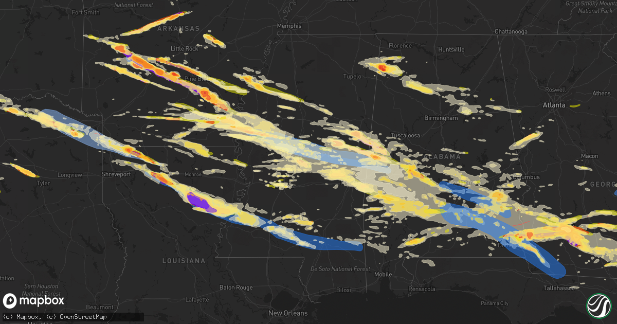
Hail Map in Mississippi on June 14, 2023
Get this storm
June 14 map
$229
one time, instant access
Download today. No call, no setup
Keep the $229
Bought the map and want the full workflow? Apply the entire $229 to a subscription within 7 days. None of it is wasted.
Every map, not just this one
This buys you this map. Subscription and you get every map we run, in the markets you choose from a few cities to whole states to nationwide. Plus real-time alerts the moment a storm fires.
Contact data
Name, contact info, occupancy, even credit band for addresses in the footprint. You go from where it hit to who to call.
Become the source they trust
Unlimited branding weather history reports on demand. You already have the documented answer ready for the property owner, and you are the one who showed up with it.
Property data and RoofTrace estimates
Pull up any address you have got, its value and the exact code rules for that jurisdiction, straight from One Click Code. Then RoofTrace estimates the squares, pitch, and roof value, priced the way you price.
Storm reports in Mississippi
Mississippi
| Date | Description |
|---|---|
| 06/14/20236:57 PM CDT | Tree down on highway 589 and j.m. Burge road. |
| 06/14/20236:57 PM CDT | Trees and powerlines down at the 1400 block of old highway 24. Powerline was down across a trailer... Which was unoccupied. |
| 06/14/20236:55 PM CDT | Tree down on highway 589 and scruggs road. |
| 06/14/20236:50 PM CDT | Tree down on higgins road and highway 42. |
| 06/14/20236:50 PM CDT | Multiple trees and powerlines down across southwest covington county. |
| 06/14/20236:47 PM CDT | Multiple trees downed in marion county. |
| 06/14/20236:43 PM CDT | Quarter size hail reported at midway road and highway 18. |
| 06/14/20236:38 PM CDT | Tree downed along jimmy williams rd. |
| 06/14/20236:38 PM CDT | Tree limbs and power lines were blown down in the bassfield area. |
| 06/14/20236:28 PM CDT | Tree limbs were blown down into the road near the intersection of mt. Zion road and us highway 84. |
| 06/14/20236:27 PM CDT | Tree limbs were blown down in the road on ms highway 42 outside of new hebron. |
| 06/14/20236:20 PM CDT | Trees and power lines were blown down along portions of ms highway 27 south. |
| 06/14/20236:17 PM CDT | A house in the 1100 block of carmel-new hope road was damaged... With possible major damage to the house. Additional trees and power lines were blown down in the surrou |
| 06/14/20236:16 PM CDT | Trees and power lines were blown down in the 500 block of lower brookhaven road... And the lines had caught fire. |
| 06/14/20236:12 PM CDT | Tree downed on house. |
| 06/14/20236:02 PM CDT | Branch fell through mobile home roof. |
| 06/14/20236:02 PM CDT | Trees down across hwy 51 near the lincoln/copiah line... Vehicles stranded between the downed trees. |
| 06/14/20236:00 PM CDT | Trees down around town... One tree on a truck... Driver not injured. Power is out in the area as well. |
| 06/14/20235:58 PM CDT | Report of multiple trees and power lines downed. |
| 06/14/20235:58 PM CDT | Report of multiple trees downed on hwy 28. |
| 06/14/20235:53 PM CDT | Multiple trees down across the w side of the county. |
| 06/14/20235:47 PM CDT | Ping pong size hail reported via twitter. |
| 06/14/20235:10 PM CDT | Trees were blown down along ms highway 33. |
| 06/14/20235:01 PM CDT | Trees were blown down along alcorn road and other parts of the county as well. |
| 06/14/20235:01 PM CDT | Hail up to the size of half dollars fell along neil magee road. |
| 06/14/20234:20 PM CDT | Tree fell on the house on midway road. Likely due to outflow winds. |
| 06/14/20234:13 PM CDT | Trees down in the area and other trees down around the county. |
| 06/14/20234:07 PM CDT | Tree fell on a residence in the area and other trees down around the county. |
| 06/14/20234:04 PM CDT | Measured 82 mph gust at knjw. |
| 06/14/20233:55 PM CDT | Corrects location of previous tstm wnd dmg report from bogue chitto. Trees and powerlines down across neshoba and kemper county. 25 reports of trees and 12 powerlines d |
| 06/14/20233:55 PM CDT | Trees and powerlines down across neshoba and kemper county. 25 reports of trees and 12 powerlines down... Combined between neshoba and kemper county. |
| 06/14/20233:55 PM CDT | Roof blown off an outbuilding in the coy community and large trees downed in the area. |
| 06/14/20233:54 PM CDT | Reports of trees down in the mars hill community. |
| 06/14/20233:51 PM CDT | Corn stalks flattened by high winds in the bond community. |
| 06/14/20233:45 PM CDT | Trees down across several county roads in the s part of the county. |
| 06/14/20233:40 PM CDT | Mars hill community. |
| 06/14/20233:40 PM CDT | Quarter hail... Mars hill community. |
| 06/14/20233:35 PM CDT | Numerous trees down along hwy 16... Road is blocked. |
| 06/14/20233:22 PM CDT | Reported trees downed. |
| 06/14/20233:20 PM CDT | Reports of numerous trees down on highway 35 south of kosciusko. |
| 06/14/20233:19 PM CDT | Trees downed on vehicle. |
| 06/14/20233:16 PM CDT | Reports of trees down on west jefferson street in the kosciusko city limits. |
| 06/14/20233:16 PM CDT | Reports of numerous trees down on highway 35 north of kosciusko. |
| 06/14/20233:04 PM CDT | Trees downed on i-55. |
| 06/14/20233:04 PM CDT | Power lines downed along s carol st. |
| 06/14/20233:03 PM CDT | Yazoo valley epa reported major utility damage in the lexington... Pickens... Vaughan and ebenezer areas. |
| 06/14/20233:00 PM CDT | Reports of trees down along interstate 55... With the interstate down to one lane. Main focus is between mile marker 150 to the southwest of durant to mile marker 164 j |
| 06/14/20232:58 PM CDT | Trees and powerlines downed. |
| 06/14/20232:58 PM CDT | Trees downed. |
| 06/14/20232:58 PM CDT | Tree downed on downed on powerline hitting a home and starting a fire. |
| 06/14/20232:33 PM CDT | Reports of trees down across the city of belzoni. |
| 06/14/20232:32 PM CDT | Multiple trees and powerlines were found down throughout belzoni. |
| 06/14/20232:31 PM CDT | Major damage to the roof of the jaketown museum. |
| 06/14/20232:31 PM CDT | Utility poles and lines downed around us 49w and w jackson st. |
| 06/14/20232:20 PM CDT | Report from along crystal ridge rd. Report via social media picture. |
| 06/14/20232:13 PM CDT | Along ms highway 397... Report via social media. |
| 06/14/20232:10 PM CDT | A few sheds damaged and blown down... Some corn crop damaged in the darlove area. |
| 06/14/20232:08 PM CDT | A few large sections of the corn crop was blown down off hwy 438 and then down off hwy 61. |
| 06/14/20232:07 PM CDT | Reported on smyth lake rd... Report via social media. |
| 06/14/20232:06 PM CDT | On brooksville rd. |
| 06/14/20231:20 PM CDT | A local report indicates 1.25 inch wind near 4 W Prairie Point |
| 06/14/20231:00 PM CDT | 5+in hail reported in brooksville. |
| 06/14/202312:56 PM CDT | A local report indicates 2.50 inch wind near Brooksville |
| 06/14/202312:56 PM CDT | Twitter user posted a video from porch showing ping pong ball sized hail. |
| 06/14/202312:13 PM CDT | Large trees down. Time estimated by radar. |
| 06/14/202311:02 AM CDT | A couple trees down around the golf course. |
| 06/14/202310:18 AM CDT | A vacant mobile home damaged by winds and debris. |
| 06/14/202310:15 AM CDT | A home in between webb and sumner had damage to their pickup truck as large branches and debris fell on the vehicle. |
| 06/14/202310:12 AM CDT | Power poles taken down in the city limits of sumner... A tree uprooted... And a mobile home lost its tin roof in the sumner area. Time is radar estimated. |
| 06/14/202310:00 AM CDT | Multiple trees down on jenkins road near town of sumner. Time is radar estimated. |
| 06/14/20239:40 AM CDT | Half dollar size hail reported in golden. |
| 06/14/20239:26 AM CDT | Powerlines down near the intersection of fava and palmer roads. Time is radar estimated. |
| 06/14/20239:26 AM CDT | Corrects previous tstm wnd dmg report from 5 se bobo. Powerlines down near the intersection of fava and palmer roads and reinhart road and new africa road. Time is rada |
| 06/14/20239:26 AM CDT | Powerlines down near the intersection of fava and palmer roads and reinhart road and new africa road. Time is radar estimated. |
| 06/14/20239:24 AM CDT | Corrects time of previous tstm wnd dmg report from 1 ssw alligator. A couple trees were blown down between duncan and alligator. |
| 06/14/20239:23 AM CDT | Local air service facility had water tank moved into a car. Unofficial anemometer reading of 81 mph. Power is also out in the area. |
| 06/14/20239:20 AM CDT | A local report indicates 1.75 inch wind near 1 NE Alligator |
| 06/14/20238:24 AM CDT | A couple trees down between duncan and alligator. |
| 06/14/20236:25 AM CDT | A local report indicates 1.00 inch wind near Camden |
| 06/14/20231:39 AM CDT | Reports of golf ball size hail in the city of isola. |
| 06/14/202312:59 AM CDT | Mping report of quarter size hail on the south side of greenville. |
| 06/13/202311:45 PM CDT | Reported near ms 494 and chunky duffee rd... Report via social media. |
| 06/13/202311:37 PM CDT | Report via social media. |
| 06/13/202311:27 PM CDT | A local report indicates 1.75 inch wind near Stratton |
| 06/13/20239:30 PM CDT | Second round of golf ball sized hail. Additional damage reported to cars and homes. |
| 06/13/20239:21 PM CDT | Hail up to half dollar size near hoy rd and n old canton. |
| 06/13/20239:16 PM CDT | A local report indicates 1.00 inch wind near 1 WNW Madison |
| 06/13/20238:45 PM CDT | A local report indicates 1.00 inch wind near 4 SE Isola |
| 06/13/20238:23 PM CDT | A local report indicates 1.75 inch wind near Arcola |
| 06/13/20238:20 PM CDT | A local report indicates 1.75 inch wind near 5 W Arcola |
| 06/13/20238:16 PM CDT | A local report indicates 1.25 inch wind near 1 SSE Clinton |
| 06/13/20238:12 PM CDT | A local report indicates 1.75 inch wind near 4 N Wayside |
| 06/13/20238:08 PM CDT | Corrects time of previous hail report from 1 nne jackson. Near state st and fortification st. |
| 06/13/20238:04 PM CDT | Social media picture of quarter size hail in west jackson. |
| 06/13/20237:55 PM CDT | Tree downed at darden rd and brodie rd. |
| 06/13/20237:50 PM CDT | At the stack. |
| 06/13/20237:31 PM CDT | Numerous trees reported down along wingate road. |
| 06/13/20237:26 PM CDT | Tree blocking hwy 42 close to buck creek rd. Time using radar. |
| 06/13/20237:15 PM CDT | Khbg asos measured a 55kt or 63mph gust at 715pm. |
| 06/13/20237:14 PM CDT | Tree down. |
| 06/13/20237:11 PM CDT | A large pine tree in downtown hattiesburg fell onto and collapsed a carport... Damaging two vehicles under it. Picture relayed via twitter. |
| 06/13/20237:11 PM CDT | Several trees down and a power line in the dixie community. Lott loop... Bonhomie rd and ira hudson rd. |
| 06/13/20237:08 PM CDT | Near state st and fortification st. |
| 06/13/20237:07 PM CDT | Multiple trees and powerlines down in areas of northern forrest county and the cities of hattiesburg and petal. |
| 06/13/20237:03 PM CDT | Tree downed on moselle seminary rd. |
All States Impacted by Hail Map on June 14, 2023
Cities Impacted by Hail Map on June 14, 2023
- Claremore, OK
- Pryor, OK
- Ward, AR
- Lonoke, AR
- Austin, AR
- Carlisle, AR
- Hickory Plains, AR
- Des Arc, AR
- Hazen, AR
- Biscoe, AR
- Salina, OK
- Locust Grove, OK
- Rose, OK
- Tahlequah, OK
- Oaks, OK
- Twin Oaks, OK
- Kansas, OK
- Colcord, OK
- Eastman, GA
- Cadwell, GA
- Chauncey, GA
- McRae Helena, GA
- Dublin, GA
- Alamo, GA
- Rentz, GA
- Glenwood, GA
- Proctor, OK
- Westville, OK
- Watts, OK
- Stilwell, OK
- Mount Vernon, GA
- Uvalda, GA
- Ailey, GA
- Lincoln, AR
- Summers, AR
- Canehill, AR
- Chelsea, OK
- Siloam Springs, AR
- Fayetteville, AR
- Prairie Grove, AR
- Farmington, AR
- Evansville, AR
- Morrow, AR
- West Fork, AR
- Vidalia, GA
- Winslow, AR
- Marietta, OK
- Kingston, OK
- Lebanon, OK
- Clarksdale, MS
- Alligator, MS
- Duncan, MS
- Golden, MS
- Belmont, MS
- Dennis, MS
- New Site, MS
- Red Bay, AL
- Vina, AL
- Tutwiler, MS
- Hodges, AL
- Russellville, AL
- Phil Campbell, AL
- Spruce Pine, AL
- Sumner, MS
- Charleston, MS
- Colbert, OK
- Calera, OK
- Hendrix, OK
- Durant, OK
- Bokchito, OK
- Hackleburg, AL
- Bear Creek, AL
- Haleyville, AL
- Cascilla, MS
- Abbeville, AL
- Morris, GA
- Grenada, MS
- Scobey, MS
- Ivanhoe, TX
- Telephone, TX
- Dodd City, TX
- Windom, TX
- Honey Grove, TX
- Bonham, TX
- Petty, TX
- Shorterville, AL
- Coffeeville, MS
- Fort Gaines, GA
- Clayton, AL
- Roxton, TX
- Brookston, TX
- Paris, TX
- Bogata, TX
- Deport, TX
- Pattonville, TX
- Clarksville, TX
- Mount Pleasant, TX
- Talco, TX
- Detroit, TX
- Blossom, TX
- Bagwell, TX
- Annona, TX
- Cookville, TX
- Avery, TX
- De Kalb, TX
- Carrollton, GA
- Waco, GA
- Blakely, GA
- Eufaula, AL
- Simms, TX
- Omaha, TX
- Georgetown, GA
- Naples, TX
- New Boston, TX
- Bluffton, GA
- Alton, MO
- Couch, MO
- Gatewood, MO
- Doniphan, MO
- Columbia, AL
- Marietta, TX
- Douglassville, TX
- Hughes Springs, TX
- Linden, TX
- Atlanta, TX
- Maud, TX
- Queen City, TX
- Texarkana, TX
- Bloomburg, TX
- Doddridge, AR
- Brooksville, MS
- Macon, MS
- Double Springs, AL
- Lynn, AL
- Nauvoo, AL
- Hogansville, GA
- Lagrange, GA
- Franklin, GA
- Arley, AL
- Houston, AL
- Jasper, AL
- Oneonta, AL
- Altoona, AL
- Grantville, GA
- Damascus, GA
- Arlington, GA
- Leary, GA
- Morgan, GA
- Newton, GA
- Albany, GA
- Ackerman, MS
- Beebe, AR
- Marietta, MS
- Sumner, TX
- Springville, AL
- Chouteau, OK
- Montgomery, AL
- Pike Road, AL
- Catoosa, OK
- Mount Judea, AR
- Pelsor, AR
- Phenix City, AL
- Smiths Station, AL
- Salem, AL
- Overbrook, OK
- Cusseta, AL
- Valley, AL
- De Valls Bluff, AR
- Opelika, AL
- Thayer, MO
- Troy, AL
- Deer, AR
- Marked Tree, AR
- Banks, AL
- Louisville, AL
- Headland, AL
- Conway, AR
- Elko, GA
- Unadilla, GA
- Holcomb, MS
- Cherokee, AL
- Eupora, MS
- Lyon, MS
- Crumrod, AR
- Lambert, MS
- Mellwood, AR
- Drew, MS
- Pinson, AL
- Gore Springs, MS
- Duck Hill, MS
- Midland City, AL
- Tallassee, AL
- Notasulga, AL
- Dadeville, AL
- Camp Hill, AL
- Waverly, AL
- Auburn, AL
- Hanceville, AL
- Madill, OK
- Shellman, GA
- Cleveland, AL
- Cullman, AL
- Hayden, AL
- Blountsville, AL
- Mathiston, MS
- Bellefontaine, MS
- Cuthbert, GA
- Tuscumbia, AL
- Harrell, AR
- Camden, AR
- Hampton, AR
- Cartwright, OK
- Remlap, AL
- Newville, AL
- Lanett, AL
- Calhoun City, MS
- Bowdon, GA
- Heflin, AL
- Muscadine, AL
- Fruithurst, AL
- Ranburne, AL
- Anniston, AL
- Vance, MS
- Fulton, MS
- Baldwyn, MS
- Clopton, AL
- Mead, OK
- Elaine, AR
- De Witt, AR
- Ethel, AR
- Casscoe, AR
- Roe, AR
- Stuttgart, AR
- Sturgis, MS
- Ozark, AL
- Dawson, GA
- Newton, AL
- Dothan, AL
- Fort Rucker, AL
- Scott, AR
- Koshkonong, MO
- Mantachie, MS
- Tremont, MS
- Booneville, MS
- Leighton, AL
- Walthall, MS
- Chester, AR
- Spavinaw, OK
- Eucha, OK
- Jay, OK
- Adair, OK
- Five Points, AL
- Bennington, OK
- Sulphur Bluff, TX
- Ravenna, TX
- Pottsboro, TX
- Aliceville, AL
- Bivins, TX
- Rodessa, LA
- Vivian, LA
- Hosston, LA
- Ida, LA
- Plain Dealing, LA
- Moreland, GA
- Bradley, AR
- Fouke, AR
- Springhill, LA
- Sarepta, LA
- Cotton Valley, LA
- Crane Hill, AL
- Bremen, AL
- Benton, LA
- Shongaloo, LA
- Minden, LA
- Eutaw, AL
- Boligee, AL
- Haynesville, LA
- Homer, LA
- Louisville, MS
- Durant, MS
- West, MS
- Sallis, MS
- Kosciusko, MS
- Conyers, GA
- Loganville, GA
- Oxford, GA
- Covington, GA
- Weogufka, AL
- Rockford, AL
- Pell City, AL
- Odenville, AL
- Riverside, AL
- Lincoln, AL
- Ragland, AL
- Hollandale, MS
- Baconton, GA
- Valdosta, GA
- Arcadia, LA
- Naylor, GA
- Stockton, GA
- Leesburg, GA
- Oakfield, GA
- Warwick, GA
- Ashburn, GA
- Sylvester, GA
- Shuqualak, MS
- Preston, MS
- Greensboro, AL
- Newbern, AL
- Uniontown, AL
- Marion Junction, AL
- Marion, AL
- Athens, LA
- Gibsland, LA
- Millbrook, AL
- Simsboro, LA
- Dubach, LA
- Scooba, MS
- Belzoni, MS
- Lexington, MS
- Pickens, MS
- Silver City, MS
- Tchula, MS
- Isola, MS
- Goodman, MS
- Quitman, LA
- Ruston, LA
- Fitzgerald, GA
- Abbeville, GA
- Rochelle, GA
- Rebecca, GA
- Selma, AL
- Emelle, AL
- Bienville, LA
- Grambling, LA
- Chatham, LA
- Eros, LA
- Rhine, GA
- Choudrant, LA
- Chula, GA
- Tifton, GA
- Sycamore, GA
- Ocilla, GA
- Jonesboro, LA
- Indianola, MS
- Leland, MS
- Inverness, MS
- Greenville, MS
- Itta Bena, MS
- Yazoo City, MS
- Cruger, MS
- Sardis, AL
- Epes, AL
- Gainesville, AL
- Grayson, LA
- Columbia, LA
- Benton, MS
- West Monroe, LA
- Vaughan, MS
- Camden, MS
- Philadelphia, MS
- Carthage, MS
- Union, MS
- McCool, MS
- Noxapater, MS
- Ethel, MS
- Kelly, LA
- Wray, GA
- Olla, LA
- Winnsboro, LA
- Sawyerville, AL
- Collinsville, MS
- De Kalb, MS
- Daleville, MS
- Harrisonburg, LA
- Enterprise, LA
- Fort Necessity, LA
- Forkland, AL
- Waldron, AR
- Ambrose, GA
- Douglas, GA
- Porterville, MS
- Lauderdale, MS
- York, AL
- Livingston, AL
- Jacksonville, GA
- Broxton, GA
- Sicily Island, LA
- Wisner, LA
- Gilbert, LA
- Sikes, LA
- Clayton, LA
- Ferriday, LA
- Saint Joseph, LA
- Poulan, GA
- Sumner, GA
- Ty Ty, GA
- Harvey, AR
- Hot Springs Village, AR
- Hot Springs National Park, AR
- Lonsdale, AR
- Waterproof, LA
- Hayneville, AL
- Autaugaville, AL
- Lowndesboro, AL
- Tyler, AL
- Hope Hull, AL
- Letohatchee, AL
- Ramer, AL
- Lapine, AL
- Mathews, AL
- Fitzpatrick, AL
- Grady, AL
- Union Springs, AL
- Malvern, AR
- Benton, AR
- Lorman, MS
- Doerun, GA
- Plainview, AR
- Natchez, MS
- Fayette, MS
- Port Gibson, MS
- Midway, AL
- Scurry, TX
- Doyline, LA
- Forest, MS
- Lake, MS
- Morton, MS
- Dubberly, LA
- Vicksburg, MS
- Kilgore, TX
- Sweet Water, AL
- Meridian, MS
- Pelahatchie, MS
- Rayville, LA
- Tyler, TX
- Newton, MS
- Catherine, AL
- Waskom, TX
- Orrville, AL
- Shreveport, LA
- Ward, AL
- Clinton, MS
- Lisman, AL
- Winona, TX
- Mabank, TX
- Greenwood, LA
- Ben Wheeler, TX
- Delhi, LA
- Elm Grove, LA
- Hickory, MS
- Eustace, TX
- Enterprise, MS
- Bossier City, LA
- Edwards, MS
- Monroe, LA
- Safford, AL
- Pennington, AL
- Brandon, MS
- Haughton, LA
- Jachin, AL
- Chunky, MS
- Linden, AL
- Lawrence, MS
- Thomaston, AL
- Longview, TX
- Ennis, TX
- Jackson, MS
- Marshall, TX
- Tallulah, LA
- Hallsville, TX
- Bolton, MS
- Kemp, TX
- Alberta, AL
- Canton, TX
- Flowood, MS
- Heflin, LA
- Calhoun, LA
- Midlothian, TX
- Parks, AR
- Traskwood, AR
- Silver Creek, MS
- Prentiss, MS
- Newhebron, MS
- Wills Point, TX
- Edgewood, TX
- Roxie, MS
- Sheridan, AR
- Moultrie, GA
- Norman Park, GA
- Omega, GA
- Sims, AR
- Story, AR
- Mount Ida, AR
- Bauxite, AR
- Waxahachie, TX
- Red Oak, TX
- Minter, AL
- Forest Home, AL
- Fort Deposit, AL
- Danville, AR
- Ola, AR
- Grand Saline, TX
- Fruitvale, TX
- Royal, AR
- Brookhaven, MS
- Union Church, MS
- Wesson, MS
- McCall Creek, MS
- Meadville, MS
- Pattison, MS
- Hazlehurst, MS
- Jessieville, AR
- Palmer, TX
- Georgiana, AL
- Honoraville, AL
- Greenville, AL
- Highland Home, AL
- Goshen, AL
- Luverne, AL
- Rutledge, AL
- Glenwood, AL
- Brantley, AL
- Dozier, AL
- Pearcy, AR
- Van, TX
- Camilla, GA
- Sale City, GA
- Hartsfield, GA
- Mountain Pine, AR
- Lindale, TX
- Sparks, GA
- Adel, GA
- Nashville, GA
- Brundidge, AL
- Elba, AL
- Ariton, AL
- Clio, AL
- Enterprise, AL
- Jack, AL
- New Brockton, AL
- Collins, MS
- Bonnerdale, AR
- Rice, TX
- Chatfield, TX
- Pittsview, AL
- Perry, GA
- Montezuma, GA
- Lafayette, AL
- Marion, LA
- Rosston, AR
- Rainbow City, AL
- Gadsden, AL
- Moody Afb, GA
- Lakeland, GA
- Chidester, AR
- Stephens, AR
- Shepherd, MT
- Bastrop, LA
- Goodwater, AL
- Bellamy, AL
- Jemison, AL
- Clanton, AL
- Thorsby, AL
- Holly Pond, AL
- Horton, AL
- Camden, AL
- Starkville, MS
- Hamilton, AL
- Prattville, AL
- Richland, GA
- Lumpkin, GA
- Weston, GA
- Parrott, GA
- Lake Park, GA
- Faunsdale, AL
- Dixie, GA
- Pavo, GA
- Little Rock, AR
- Talladega, AL
- Bryant, AR
- Lizella, GA
- Knoxville, GA
- Baileyton, AL
- Lenox, GA
- Luthersville, GA
- Lake Village, AR
- Monticello, AR
- Fountain Hill, AR
- Hamburg, AR
- Dermott, AR
- Montrose, AR
- Hermitage, AR
- Wilmar, AR
- Ashville, AL
- Hahira, GA
- Oxford, AL
- Munford, AL
- Sharpsburg, GA
- Millerville, AL
- Ashland, AL
- Bonaire, GA
- Fort Valley, GA
- Centerville, GA
- Byron, GA
- Warner Robins, GA
- Buena Vista, GA
- Edison, GA
- Taylor, AR
- Magnolia, AR
- Lewisville, AR
- Emerson, AR
- Quitman, GA
- Morven, GA
- Hope, AR
- Fulton, AR
- Pine Apple, AL
- Epps, LA
- Fayetteville, GA
- Enigma, GA
- Wellington, AL
- Jacksonville, AL
- Ohatchee, AL
- Piedmont, AL
- Jacksonville, FL
- Seale, AL
- Fort Mitchell, AL
- Fort Benning, GA
- Newnan, GA
- Parma, MO
- Coosada, AL
- Gallion, AL
- Gallant, AL
- Steele, AL
- Guntersville, AL
- Ozan, AR
- Lakehurst, NJ
- Moorhead, MS
- Mansfield, TX
- Attalla, AL
- Addison, AL
- Logan, AL
- Trafford, AL
- Warrior, AL
- Eastaboga, AL
- Locust Fork, AL
- Moody, AL
- Prescott, AR
- Alapaha, GA
- Demopolis, AL
- Ray City, GA
- Crawford, MS
- Greenville, GA
- Senoia, GA
- Eclectic, AL
- Wetumpka, AL
- West Point, GA
- Gay, GA
- Fort Pierce, FL
- Jonesboro, GA
- Hamilton, GA
- Shiloh, GA
- Hartford, AR
- Oak Ridge, LA
- Sondheimer, LA
- Boaz, AL
- Hensley, AR
- Barney, GA
- Tuskegee, AL
- Shorter, AL
- Weir, MS
- Sibley, LA
- Coleman, GA
- Hurtsboro, AL
- Hardaway, AL
- Ashford, AL
- Arabi, GA
- Willacoochee, GA
- Hatchechubbee, AL
- Cecil, AL
- Deatsville, AL
- Norman, AR
- White Hall, AR
- Jefferson, AR
- Pine Bluff, AR
- Sherrill, AR
- Brooklet, GA
- Guyton, GA
- Rincon, GA
- Springfield, GA
- Altheimer, AR
- Redfield, AR
- Powell, TX
- Kerens, TX
- Raymond, MS
- Dardanelle, AR
- Casa, AR
- Morrilton, AR
- Pottsville, AR
- Atkins, AR
- Skipperville, AL
- Webb, AL
- Cowarts, AL
- Solgohachia, AR
- Springfield, AR
- Bogue Chitto, MS
- Sontag, MS
- Ruth, MS
- Monticello, MS
- Jayess, MS
- Oak Vale, MS
- Columbia, MS
- Kokomo, MS
- Carson, MS
- Foxworth, MS
- Sumrall, MS
- Lumberton, MS
- Bassfield, MS
- Hattiesburg, MS
- Damascus, AR
- Hattieville, AR
- Center Ridge, AR
- Colquitt, GA
- Jakin, GA
- Pansey, AL
- Donalsonville, GA
- Gordon, AL
- Bascom, FL
- Cottonwood, AL
- Donaldson, AR
- Leola, AR
- Poyen, AR
- Grapevine, AR
- Rison, AR
- Prattsville, AR
- Brinson, GA
- Greenbrier, AR
- Quitman, AR
- Iron City, GA
- Whigham, GA
- Cairo, GA
- Climax, GA
- Bainbridge, GA
- Quincy, FL
- Attapulgus, GA
- Richton, MS
- Petal, MS
- Beaumont, MS
- Purvis, MS
- Leakesville, MS
- McLain, MS
- New Augusta, MS
- Neely, MS
- Pearl, MS
- Richland, MS
- Ridgeland, MS
- Gould, AR
- Gillett, AR
- Tichnor, AR
- Watson, AR
- Gunnison, MS
- Snow Lake, AR
- Timbo, AR
- Onia, AR
- Leslie, AR
- Fifty Six, AR
- Maynard, AR
- Success, AR
- Naylor, MO
- Corning, AR
- Star City, AR
- Grady, AR
- Tillar, AR
- Dumas, AR
- Pickens, AR
- Winchester, AR
- Knobel, AR
- Piggott, AR
- Rector, AR
- Marmaduke, AR
- Lafe, AR
- Thomasville, GA
- Havana, FL
- Tallahassee, FL
- Lucedale, MS
- State Line, MS
- Mena, AR
- Caddo Gap, AR
- Glenwood, AR
- Melbourne, AR
- Mountain View, AR
- McGehee, AR
- Banks, AR
- Warren, AR
- Amity, AR
- Arkansas City, AR
- Rohwer, AR
- Benoit, MS
- Kennett, MO
- Senath, MO
- Paragould, AR
- Brockwell, AR
- Guion, AR
- Violet Hill, AR
- Sage, AR
- Horseshoe Bend, AR
- Franklin, AR
- Evening Shade, AR
- Ash Flat, AR
- Arkadelphia, AR
- Madison, MS
- Hardy, AR
- Thornton, AR
- Canton, MS
- Decatur, MS
- Fordyce, AR
- New Edinburg, AR
- Springdale, AR
- Elkins, AR
- Hindsville, AR
- Wesley, AR
- Huntsville, AR
- Witter, AR
- Magnolia, AL
- Mashpee, MA
- Sandwich, MA
- Boyes, MT
- Livermore, CO
- Carthage, AR
- Grove Hill, AL
- Meredith, NH
- Center Harbor, NH
- New Hampton, NH
- Dixons Mills, AL
- Butler, AL
- Black, AL
- Hartford, AL
- Beech Grove, AR
- Walnut Ridge, AR
- Lowell, AR
- Cave Springs, AR
- Seminary, MS
- Ellisville, MS
- Lindsay, MT
- Satartia, MS
- Redwood, MS
- Atmore, AL
- Little River, AL
- Deer Park, AL
- Fruitdale, AL
- Cuttyhunk, MA
- Woods Hole, MA
- East Falmouth, MA
- Buzzards Bay, MA
- Falmouth, MA
- Jones, AL
- Repton, AL
- Range, AL
- Brewton, AL
- Clinton, AR
- Dennard, AR
- Delaplaine, AR
- Tie Siding, WY
- Du Pont, GA
- Fargo, GA
- Circle, MT
- Bismarck, AR
- Richey, MT
- Shaw, MS
- Toomsuba, MS
- North Palm Beach, FL
- Coolidge, GA
- Saint Paul, AR
- Boston, GA
- Cheyenne, WY
- Waynesboro, MS
- Rogers, AR
- Toxey, AL
- Silas, AL
- Pine Hill, AL
- Shubuta, MS
- Thomasville, AL
- Coffeeville, AL
- Lower Peach Tree, AL
- Gilbertown, AL
- Mount Olive, MS
- Town Creek, AL
- Frankville, AL
- Jackson, AL
- Millry, AL
- Guy, AR
- Needham, AL
- Dickinson, AL
- Coy, AL
- Whatley, AL
- Little Compton, RI
- New Bedford, MA
- North Dartmouth, MA
- South Dartmouth, MA
- Rochester, MA
- Westport, MA
- Acushnet, MA
- Daleville, AL
- Andalusia, AL
- Red Level, AL
- Chancellor, AL
- Stockton, AL
- Mount Vernon, AL
- Citronelle, AL
- McIntosh, AL
- Vinegar Bend, AL
- Soperton, GA
- Homerville, GA
- Witts Springs, AR
- Hilliard, FL
- Biggers, AR
- Warm Springs, AR
- Pollard, AR
- Arbyrd, MO
- Hornersville, MO
- Cardwell, MO
- Peach Orchard, AR
- Neelyville, MO
- Wagarville, AL
- Chatom, AL
- Tibbie, AL
- Palm Beach Gardens, FL
- Venus, TX
- Yorktown, AR
- Opp, AL
- Loxahatchee, FL
- Pinola, MS
- Barry, TX
- Blooming Grove, TX
- Greenwood, MS
- Carrollton, MS
- Eudora, AR
- Evergreen, AL
- Monticello, FL
- McKenzie, AL
- Moulton, AL
- Marshall, AR
- Statenville, GA
- Newellton, LA
- Perdido, AL
- Bay Minette, AL
- Lame Deer, MT
- North Little Rock, AR
- Alvarado, TX
- Mount Hope, AL
- West Yarmouth, MA
- South Yarmouth, MA
- Belcher, LA
- Mize, MS
- Taylorsville, MS
- Pettigrew, AR
- Doddsville, MS
- Cuba, AL
- Lamont, FL
- Castleberry, AL
- Terrell, TX
- Hermanville, MS
- Mendenhall, MS
- Magee, MS
- Sunflower, AL
- Ponca, AR
- Kingston, AR
- Shirley, AR
- Kingsland, GA
- Yulee, FL
- Campbell, AL
- Melvin, AL
- Tishomingo, MS
- Roberta, GA
- Pinetta, FL
- Sidon, MS
- McDavid, FL
- Saint Stephens, AL
- Saint Charles, AR
- Pocahontas, AR
- Ellenton, GA
- Funston, GA
- Berlin, GA
- Pencil Bluff, AR
- Saint George, GA
- Little Rock, MS
- Marion, MS
- Quitman, MS
- Beatrice, AL
- High Springs, FL
- Branford, FL
- Alachua, FL
- Williston, FL
- Newberry, FL
- Gainesville, FL
- Bell, FL
- Archer, FL
- Bronson, FL
- Chiefland, FL
- Old Town, FL
- Trenton, FL
- Micanopy, FL
- Meriden, WY
- Otter, MT
- Scotland, AR
- Scottsbluff, NE
- Arlington, AL
- Tilly, AR
- Hector, AR
- Walnut Grove, MS
- Flora, MS
- Lena, MS
- Byram, MS
- Bentonia, MS
- Conehatta, MS
- Bailey, MS
- Maben, MS
- Jay, FL
- Milton, FL
- Century, FL
- Eastham, MA
- Stewart, MS
- Kilmichael, MS
- French Camp, MS
- Enid, MS
- Flomaton, AL
- El Dorado, AR
- Schlater, MS
- Philipp, MS
- Sunflower, MS
- Vredenburgh, AL
- Portland, AR
- Bearden, AR
- Peterman, AL
- Sebastopol, MS
- Bonita, LA
- Uriah, AL
- Frisco City, AL
- Lake Providence, LA
- Transylvania, LA
- Mayersville, MS
- Rolling Fork, MS
- Valley Park, MS
- Titus, AL
- Gordo, AL
- Vaiden, MS
- Lenox, AL
- Brent, AL
- Knoxville, AL
- Louise, MS
- Spearsville, LA
- Jersey, AR
- Strong, AR
- Anguilla, MS
- Fosters, AL
- Ralph, AL
- Moundville, AL
- Akron, AL
- Danville, AL
- Decatur, AL
- Centreville, AL
- Huttig, AR
- Crossett, AR
- Mer Rouge, LA
- Buhl, AL
- Lawley, AL
- Mount Holly, AR
- Junction City, AR
- Monroeville, AL
- Carrollton, AL
- Booth, AL
- Tinsley, MS
- Elmore, AL
- Marbury, AL
- Parkdale, AR
- Billingsley, AL
- Saraland, AL
- Verbena, AL
- Tuscaloosa, AL
- Bishop, TX
- Oak Grove, LA
- Pioneer, LA
- Holly Grove, AR
- Marvell, AR
- Plantersville, AL


