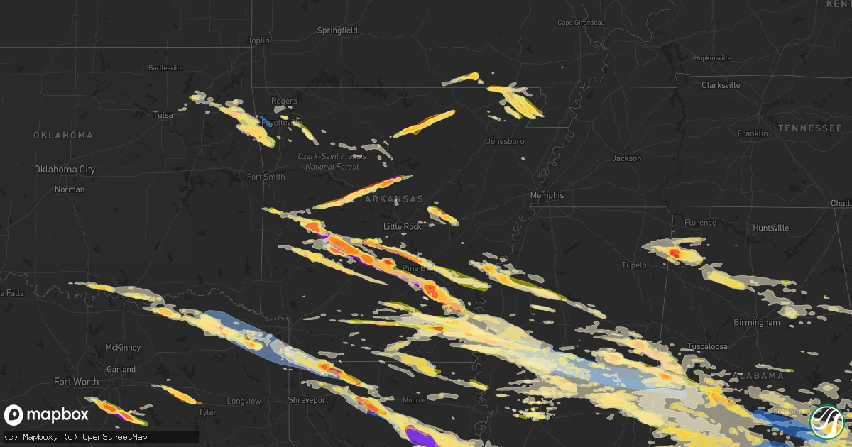
Hail Map in Arkansas on June 14, 2023
Get this storm
June 14 map
$229
one time, instant access
Download today. No call, no setup
Keep the $229
Bought the map and want the full workflow? Apply the entire $229 to a subscription within 7 days. None of it is wasted.
Every map, not just this one
This buys you this map. Subscription and you get every map we run, in the markets you choose from a few cities to whole states to nationwide. Plus real-time alerts the moment a storm fires.
Contact data
Name, contact info, occupancy, even credit band for addresses in the footprint. You go from where it hit to who to call.
Become the source they trust
Unlimited branding weather history reports on demand. You already have the documented answer ready for the property owner, and you are the one who showed up with it.
Property data and RoofTrace estimates
Pull up any address you have got, its value and the exact code rules for that jurisdiction, straight from One Click Code. Then RoofTrace estimates the squares, pitch, and roof value, priced the way you price.
Storm reports in Arkansas
Arkansas
| Date | Description |
|---|---|
| 06/14/20236:55 PM CDT | Baseball to softball sized hail reported by trained storm spotter 5 miles east of landers on country club rd in grant county. |
| 06/14/20236:52 PM CDT | Reports of quarter sized hail 6 miles south of sheridan. |
| 06/14/20236:50 PM CDT | Report from mping: ping pong ball |
| 06/14/20236:50 PM CDT | Report from mping: golf ball |
| 06/14/20236:49 PM CDT | Report from mping: ping pong ball |
| 06/14/20236:45 PM CDT | A local report indicates 2.50 inch wind near 1 N Springfield |
| 06/14/20236:38 PM CDT | Report from mping: half dollar |
| 06/14/20236:38 PM CDT | About 7 miles south of malvern baseball sized hail was reported with windows broken by the hail at the residence. |
| 06/14/20236:21 PM CDT | Report of quarter sized hail sent to the office via twitter. |
| 06/14/20236:20 PM CDT | Broadcast media shared a measured 3 inch hail stone from the malvern area when the supercell pass through approximately an hour ago. Exact location and time are estimat |
| 06/14/20236:16 PM CDT | Measured 1 inch hail in malvern. |
| 06/14/20236:12 PM CDT | Report from mping: golf ball |
| 06/14/20236:11 PM CDT | Tea cup sized hail was reported on lake shore and easy terrace |
| 06/14/20236:06 PM CDT | Tennis ball sized hail and 65 mph winds reported near red oak... Intersection of far shores and red oak roads. |
| 06/14/20236:05 PM CDT | A local report indicates 1.00 inch wind near Pine Bluff Arsenal |
| 06/14/20236:01 PM CDT | Report from mping: golf ball |
| 06/14/20236:00 PM CDT | Baseball to softball sized hail was reported at the crystal springs campground northwest of royal on lake ouachita. Significant damage to vehicles and campground equipm |
| 06/14/20235:55 PM CDT | Report from mping: baseball |
| 06/14/20235:55 PM CDT | Report from mping: tennis ball |
| 06/14/20235:55 PM CDT | Reported tennis ball sized hail in pearcy... On fair park and chariot streets. |
| 06/14/20235:51 PM CDT | Report from mping: quarter |
| 06/14/20235:50 PM CDT | Baseball sized hail reported to ham radio net control on brady mountain road. |
| 06/14/20235:50 PM CDT | Corrects previous hail report from pearcy. Additional social media pictures of baseball sized hail near pearcy. Time is estimated from radar. |
| 06/14/20235:50 PM CDT | Several hailstones 3-4 inches in diameter shown in pictures next to tape measure for reference. |
| 06/14/20235:42 PM CDT | *delayed report* social media pictures of potentially tennis ball sized hail near the mason township east of ola... No scale was provided in the pictures. Time is estim |
| 06/14/20235:42 PM CDT | *delayed report* social media pictures of potentially tennis ball sized hail near the mason township east of ola... No scale was provided in the pictures. Time is estim |
| 06/14/20235:33 PM CDT | The mount ida nws little rock cooperative weather observer reported many trees blown down at the intersection of 188 and 27n... And then all along lake ouachita in mont |
| 06/14/20235:33 PM CDT | Report from mping: half dollar |
| 06/14/20235:24 PM CDT | Trees also reportedly blown down in the area. |
| 06/14/20235:10 PM CDT | Numerous large hailstones shown in pictures via social media. |
| 06/14/20235:03 PM CDT | Shared with nws forecasters via cell phone picture. |
| 06/14/20235:02 PM CDT | Picture of golfball sized hail shared on twitter. |
| 06/14/20235:01 PM CDT | *delayed report* social media picture of half dollar sized hail taken from the haskell exit |
| 06/14/20234:58 PM CDT | Report from mping: quarter |
| 06/14/20234:57 PM CDT | Report from mping: quarter |
| 06/14/20234:45 PM CDT | Corrects the event time from the previous hail report from lonsdale. Picture of golfball sized hail shared on twitter. Time is estimated from radar data. |
| 06/14/20234:30 PM CDT | Picture of trees downed in waldron shared to the broadcast media from scott county emergency management. Time is estimated from radar. |
| 06/14/20232:39 PM CDT | A local report indicates 59 MPH wind near 2 S El Dorado |
| 06/14/20231:40 PM CDT | Several trees snapped from along a path from lake erling to near taylor... Arkansas. |
| 06/14/20231:24 PM CDT | Reports of trees down on county roads 47 and 57. |
| 06/14/20231:19 PM CDT | On i-49 between fouke ar and ida la. |
| 06/14/20231:18 PM CDT | Straight-line winds were confirmed from cass county... Tx across southern miller county... Ar to northern bossier parish... La. Trees were uprooted and snapped along a |
| 06/14/20231:15 PM CDT | Reports of powerlines down on main street. |
| 06/14/20231:15 PM CDT | Reports of power outages. |
| 06/14/20231:00 PM CDT | Reports of trees down along ar 160. |
| 06/14/20231:00 PM CDT | Reports of power outages. |
| 06/14/202312:55 PM CDT | Several trees down along miller county road 75... About a mile or so east of bloomburg... Tx. |
| 06/14/20239:14 AM CDT | Hail at least golfball size damaging windows and some vehicles. |
| 06/14/20238:55 AM CDT | Large tent blown down in northwest arkansas mall parking lot. |
| 06/14/20238:42 AM CDT | Large tree uprooted and lying on top of house. Pic via twitter... Time estimated from radar. |
| 06/14/20238:41 AM CDT | Tree blown down in back yard... Pic via twitter. Time estimated from radar. |
| 06/14/20238:41 AM CDT | Tree blown down...time estimated from radar. |
| 06/14/20238:40 AM CDT | Picture via twitter. Time estimated from radar. |
| 06/14/20238:40 AM CDT | Trees blown down in valley view estates in farmington. Time estimated from radar. |
| 06/14/20238:37 AM CDT | Pic and video via twitter. Time estimated from radar. Many golfball size with a few larger stones. |
| 06/14/20238:34 AM CDT | Picture via twitter. Time estimated from radar. |
| 06/14/20238:15 AM CDT | Tree uprooted. Picture relayed by broadcast media via twitter. Time estimated from radar. |
| 06/14/20238:15 AM CDT | Tree uprooted. Picture relayed by broadcast media via twitter. Time estimated from radar. |
| 06/13/20239:47 PM CDT | Public reports half dollar size hail. |
| 06/13/20239:30 PM CDT | A local report indicates 1.00 inch wind near Arkadelphia |
| 06/13/20239:10 PM CDT | *delayed report* numerous pictures of baseball to softball sized hail with in-picture scales from near terrell road in degray. Pictures were relayed from a broadcast me |
| 06/13/20239:04 PM CDT | Public report video on twitter of hail in marmaduke. |
| 06/13/20239:03 PM CDT | Video from public on twitter driving on highway 34 west of marmaduke. |
| 06/13/20238:35 PM CDT | Hail larger than quarter size fell at the intersection of highways 90 and 135. Time is radar estimated. |
| 06/13/20238:32 PM CDT | Report of two trees downed. |
| 06/13/20238:30 PM CDT | Report via social media from local broadcast media outlet. Several hail stones from near 1 inch to around 1.5 inches. |
| 06/13/20238:30 PM CDT | Public estimates quarter sized hail along county road 325. |
| 06/13/20238:30 PM CDT | The mount ida coop observer reported golf ball sized hail falling in the community of hopper at this time. |
| 06/13/20238:20 PM CDT | Public report of quarter sized hail along county road 110. |
| 06/13/20238:19 PM CDT | Corrects time from previous hail report from 1 e hopper. The mount ida coop observer reported golf ball sized hail falling in the community of hopper at this time. |
| 06/13/20238:16 PM CDT | Reported ping pong ball to golfball sized hail. Location estimated... Mobile spotter. |
| 06/13/20238:09 PM CDT | Public report of quarter sized hail. |
| 06/13/20238:09 PM CDT | Corrects previous hail report from rector. Public report of 1.5 inch hail... From kait. |
| 06/13/20238:05 PM CDT | A local report indicates 2.50 inch wind near TYRO |
| 06/13/20238:02 PM CDT | Corrects the time from previous hail report from garrett bridge. Reported ping pong ball to golfball sized hail. Location estimated... Mobile spotter. |
| 06/13/20237:58 PM CDT | Picture of hen egg sized hail shared with the office on twitter. Time estimated. |
| 06/13/20237:58 PM CDT | Broadcast media shared a picture of 3.5 inch diameter hail via twitter. Time is estimated. |
| 06/13/20237:50 PM CDT | A local report indicates 2.50 inch wind near 2 S Star City |
| 06/13/20237:50 PM CDT | Corrects time of previous hail report from star city. Picture of hen egg sized hail shared with the office on twitter. Time estimated. |
| 06/13/20237:50 PM CDT | Corrects time and size from previous hail report from star city. Broadcast media shared a picture of 4 inch diameter hail via twitter. Time is estimated from radar data |
| 06/13/20237:13 PM CDT | Public shared a picture of hail next to a quarter... Fairly easy to see that it is at least two quarters wide. Two inch hail measured in damascus. |
| 06/13/20237:06 PM CDT | Initially... A large amount of half-dollar sized hail was falling... Covering portions of highway 65. Hail was up to the size of golfballs at the time of the phone call |
All States Impacted by Hail Map on June 14, 2023
Cities Impacted by Hail Map on June 14, 2023
- Claremore, OK
- Pryor, OK
- Ward, AR
- Lonoke, AR
- Austin, AR
- Carlisle, AR
- Hickory Plains, AR
- Des Arc, AR
- Hazen, AR
- Biscoe, AR
- Salina, OK
- Locust Grove, OK
- Rose, OK
- Tahlequah, OK
- Oaks, OK
- Twin Oaks, OK
- Kansas, OK
- Colcord, OK
- Eastman, GA
- Cadwell, GA
- Chauncey, GA
- McRae Helena, GA
- Dublin, GA
- Alamo, GA
- Rentz, GA
- Glenwood, GA
- Proctor, OK
- Westville, OK
- Watts, OK
- Stilwell, OK
- Mount Vernon, GA
- Uvalda, GA
- Ailey, GA
- Lincoln, AR
- Summers, AR
- Canehill, AR
- Chelsea, OK
- Siloam Springs, AR
- Fayetteville, AR
- Prairie Grove, AR
- Farmington, AR
- Evansville, AR
- Morrow, AR
- West Fork, AR
- Vidalia, GA
- Winslow, AR
- Marietta, OK
- Kingston, OK
- Lebanon, OK
- Clarksdale, MS
- Alligator, MS
- Duncan, MS
- Golden, MS
- Belmont, MS
- Dennis, MS
- New Site, MS
- Red Bay, AL
- Vina, AL
- Tutwiler, MS
- Hodges, AL
- Russellville, AL
- Phil Campbell, AL
- Spruce Pine, AL
- Sumner, MS
- Charleston, MS
- Colbert, OK
- Calera, OK
- Hendrix, OK
- Durant, OK
- Bokchito, OK
- Hackleburg, AL
- Bear Creek, AL
- Haleyville, AL
- Cascilla, MS
- Abbeville, AL
- Morris, GA
- Grenada, MS
- Scobey, MS
- Ivanhoe, TX
- Telephone, TX
- Dodd City, TX
- Windom, TX
- Honey Grove, TX
- Bonham, TX
- Petty, TX
- Shorterville, AL
- Coffeeville, MS
- Fort Gaines, GA
- Clayton, AL
- Roxton, TX
- Brookston, TX
- Paris, TX
- Bogata, TX
- Deport, TX
- Pattonville, TX
- Clarksville, TX
- Mount Pleasant, TX
- Talco, TX
- Detroit, TX
- Blossom, TX
- Bagwell, TX
- Annona, TX
- Cookville, TX
- Avery, TX
- De Kalb, TX
- Carrollton, GA
- Waco, GA
- Blakely, GA
- Eufaula, AL
- Simms, TX
- Omaha, TX
- Georgetown, GA
- Naples, TX
- New Boston, TX
- Bluffton, GA
- Alton, MO
- Couch, MO
- Gatewood, MO
- Doniphan, MO
- Columbia, AL
- Marietta, TX
- Douglassville, TX
- Hughes Springs, TX
- Linden, TX
- Atlanta, TX
- Maud, TX
- Queen City, TX
- Texarkana, TX
- Bloomburg, TX
- Doddridge, AR
- Brooksville, MS
- Macon, MS
- Double Springs, AL
- Lynn, AL
- Nauvoo, AL
- Hogansville, GA
- Lagrange, GA
- Franklin, GA
- Arley, AL
- Houston, AL
- Jasper, AL
- Oneonta, AL
- Altoona, AL
- Grantville, GA
- Damascus, GA
- Arlington, GA
- Leary, GA
- Morgan, GA
- Newton, GA
- Albany, GA
- Ackerman, MS
- Beebe, AR
- Marietta, MS
- Sumner, TX
- Springville, AL
- Chouteau, OK
- Montgomery, AL
- Pike Road, AL
- Catoosa, OK
- Mount Judea, AR
- Pelsor, AR
- Phenix City, AL
- Smiths Station, AL
- Salem, AL
- Overbrook, OK
- Cusseta, AL
- Valley, AL
- De Valls Bluff, AR
- Opelika, AL
- Thayer, MO
- Troy, AL
- Deer, AR
- Marked Tree, AR
- Banks, AL
- Louisville, AL
- Headland, AL
- Conway, AR
- Elko, GA
- Unadilla, GA
- Holcomb, MS
- Cherokee, AL
- Eupora, MS
- Lyon, MS
- Crumrod, AR
- Lambert, MS
- Mellwood, AR
- Drew, MS
- Pinson, AL
- Gore Springs, MS
- Duck Hill, MS
- Midland City, AL
- Tallassee, AL
- Notasulga, AL
- Dadeville, AL
- Camp Hill, AL
- Waverly, AL
- Auburn, AL
- Hanceville, AL
- Madill, OK
- Shellman, GA
- Cleveland, AL
- Cullman, AL
- Hayden, AL
- Blountsville, AL
- Mathiston, MS
- Bellefontaine, MS
- Cuthbert, GA
- Tuscumbia, AL
- Harrell, AR
- Camden, AR
- Hampton, AR
- Cartwright, OK
- Remlap, AL
- Newville, AL
- Lanett, AL
- Calhoun City, MS
- Bowdon, GA
- Heflin, AL
- Muscadine, AL
- Fruithurst, AL
- Ranburne, AL
- Anniston, AL
- Vance, MS
- Fulton, MS
- Baldwyn, MS
- Clopton, AL
- Mead, OK
- Elaine, AR
- De Witt, AR
- Ethel, AR
- Casscoe, AR
- Roe, AR
- Stuttgart, AR
- Sturgis, MS
- Ozark, AL
- Dawson, GA
- Newton, AL
- Dothan, AL
- Fort Rucker, AL
- Scott, AR
- Koshkonong, MO
- Mantachie, MS
- Tremont, MS
- Booneville, MS
- Leighton, AL
- Walthall, MS
- Chester, AR
- Spavinaw, OK
- Eucha, OK
- Jay, OK
- Adair, OK
- Five Points, AL
- Bennington, OK
- Sulphur Bluff, TX
- Ravenna, TX
- Pottsboro, TX
- Aliceville, AL
- Bivins, TX
- Rodessa, LA
- Vivian, LA
- Hosston, LA
- Ida, LA
- Plain Dealing, LA
- Moreland, GA
- Bradley, AR
- Fouke, AR
- Springhill, LA
- Sarepta, LA
- Cotton Valley, LA
- Crane Hill, AL
- Bremen, AL
- Benton, LA
- Shongaloo, LA
- Minden, LA
- Eutaw, AL
- Boligee, AL
- Haynesville, LA
- Homer, LA
- Louisville, MS
- Durant, MS
- West, MS
- Sallis, MS
- Kosciusko, MS
- Conyers, GA
- Loganville, GA
- Oxford, GA
- Covington, GA
- Weogufka, AL
- Rockford, AL
- Pell City, AL
- Odenville, AL
- Riverside, AL
- Lincoln, AL
- Ragland, AL
- Hollandale, MS
- Baconton, GA
- Valdosta, GA
- Arcadia, LA
- Naylor, GA
- Stockton, GA
- Leesburg, GA
- Oakfield, GA
- Warwick, GA
- Ashburn, GA
- Sylvester, GA
- Shuqualak, MS
- Preston, MS
- Greensboro, AL
- Newbern, AL
- Uniontown, AL
- Marion Junction, AL
- Marion, AL
- Athens, LA
- Gibsland, LA
- Millbrook, AL
- Simsboro, LA
- Dubach, LA
- Scooba, MS
- Belzoni, MS
- Lexington, MS
- Pickens, MS
- Silver City, MS
- Tchula, MS
- Isola, MS
- Goodman, MS
- Quitman, LA
- Ruston, LA
- Fitzgerald, GA
- Abbeville, GA
- Rochelle, GA
- Rebecca, GA
- Selma, AL
- Emelle, AL
- Bienville, LA
- Grambling, LA
- Chatham, LA
- Eros, LA
- Rhine, GA
- Choudrant, LA
- Chula, GA
- Tifton, GA
- Sycamore, GA
- Ocilla, GA
- Jonesboro, LA
- Indianola, MS
- Leland, MS
- Inverness, MS
- Greenville, MS
- Itta Bena, MS
- Yazoo City, MS
- Cruger, MS
- Sardis, AL
- Epes, AL
- Gainesville, AL
- Grayson, LA
- Columbia, LA
- Benton, MS
- West Monroe, LA
- Vaughan, MS
- Camden, MS
- Philadelphia, MS
- Carthage, MS
- Union, MS
- McCool, MS
- Noxapater, MS
- Ethel, MS
- Kelly, LA
- Wray, GA
- Olla, LA
- Winnsboro, LA
- Sawyerville, AL
- Collinsville, MS
- De Kalb, MS
- Daleville, MS
- Harrisonburg, LA
- Enterprise, LA
- Fort Necessity, LA
- Forkland, AL
- Waldron, AR
- Ambrose, GA
- Douglas, GA
- Porterville, MS
- Lauderdale, MS
- York, AL
- Livingston, AL
- Jacksonville, GA
- Broxton, GA
- Sicily Island, LA
- Wisner, LA
- Gilbert, LA
- Sikes, LA
- Clayton, LA
- Ferriday, LA
- Saint Joseph, LA
- Poulan, GA
- Sumner, GA
- Ty Ty, GA
- Harvey, AR
- Hot Springs Village, AR
- Hot Springs National Park, AR
- Lonsdale, AR
- Waterproof, LA
- Hayneville, AL
- Autaugaville, AL
- Lowndesboro, AL
- Tyler, AL
- Hope Hull, AL
- Letohatchee, AL
- Ramer, AL
- Lapine, AL
- Mathews, AL
- Fitzpatrick, AL
- Grady, AL
- Union Springs, AL
- Malvern, AR
- Benton, AR
- Lorman, MS
- Doerun, GA
- Plainview, AR
- Natchez, MS
- Fayette, MS
- Port Gibson, MS
- Midway, AL
- Scurry, TX
- Doyline, LA
- Forest, MS
- Lake, MS
- Morton, MS
- Dubberly, LA
- Vicksburg, MS
- Kilgore, TX
- Sweet Water, AL
- Meridian, MS
- Pelahatchie, MS
- Rayville, LA
- Tyler, TX
- Newton, MS
- Catherine, AL
- Waskom, TX
- Orrville, AL
- Shreveport, LA
- Ward, AL
- Clinton, MS
- Lisman, AL
- Winona, TX
- Mabank, TX
- Greenwood, LA
- Ben Wheeler, TX
- Delhi, LA
- Elm Grove, LA
- Hickory, MS
- Eustace, TX
- Enterprise, MS
- Bossier City, LA
- Edwards, MS
- Monroe, LA
- Safford, AL
- Pennington, AL
- Brandon, MS
- Haughton, LA
- Jachin, AL
- Chunky, MS
- Linden, AL
- Lawrence, MS
- Thomaston, AL
- Longview, TX
- Ennis, TX
- Jackson, MS
- Marshall, TX
- Tallulah, LA
- Hallsville, TX
- Bolton, MS
- Kemp, TX
- Alberta, AL
- Canton, TX
- Flowood, MS
- Heflin, LA
- Calhoun, LA
- Midlothian, TX
- Parks, AR
- Traskwood, AR
- Silver Creek, MS
- Prentiss, MS
- Newhebron, MS
- Wills Point, TX
- Edgewood, TX
- Roxie, MS
- Sheridan, AR
- Moultrie, GA
- Norman Park, GA
- Omega, GA
- Sims, AR
- Story, AR
- Mount Ida, AR
- Bauxite, AR
- Waxahachie, TX
- Red Oak, TX
- Minter, AL
- Forest Home, AL
- Fort Deposit, AL
- Danville, AR
- Ola, AR
- Grand Saline, TX
- Fruitvale, TX
- Royal, AR
- Brookhaven, MS
- Union Church, MS
- Wesson, MS
- McCall Creek, MS
- Meadville, MS
- Pattison, MS
- Hazlehurst, MS
- Jessieville, AR
- Palmer, TX
- Georgiana, AL
- Honoraville, AL
- Greenville, AL
- Highland Home, AL
- Goshen, AL
- Luverne, AL
- Rutledge, AL
- Glenwood, AL
- Brantley, AL
- Dozier, AL
- Pearcy, AR
- Van, TX
- Camilla, GA
- Sale City, GA
- Hartsfield, GA
- Mountain Pine, AR
- Lindale, TX
- Sparks, GA
- Adel, GA
- Nashville, GA
- Brundidge, AL
- Elba, AL
- Ariton, AL
- Clio, AL
- Enterprise, AL
- Jack, AL
- New Brockton, AL
- Collins, MS
- Bonnerdale, AR
- Rice, TX
- Chatfield, TX
- Pittsview, AL
- Perry, GA
- Montezuma, GA
- Lafayette, AL
- Marion, LA
- Rosston, AR
- Rainbow City, AL
- Gadsden, AL
- Moody Afb, GA
- Lakeland, GA
- Chidester, AR
- Stephens, AR
- Shepherd, MT
- Bastrop, LA
- Goodwater, AL
- Bellamy, AL
- Jemison, AL
- Clanton, AL
- Thorsby, AL
- Holly Pond, AL
- Horton, AL
- Camden, AL
- Starkville, MS
- Hamilton, AL
- Prattville, AL
- Richland, GA
- Lumpkin, GA
- Weston, GA
- Parrott, GA
- Lake Park, GA
- Faunsdale, AL
- Dixie, GA
- Pavo, GA
- Little Rock, AR
- Talladega, AL
- Bryant, AR
- Lizella, GA
- Knoxville, GA
- Baileyton, AL
- Lenox, GA
- Luthersville, GA
- Lake Village, AR
- Monticello, AR
- Fountain Hill, AR
- Hamburg, AR
- Dermott, AR
- Montrose, AR
- Hermitage, AR
- Wilmar, AR
- Ashville, AL
- Hahira, GA
- Oxford, AL
- Munford, AL
- Sharpsburg, GA
- Millerville, AL
- Ashland, AL
- Bonaire, GA
- Fort Valley, GA
- Centerville, GA
- Byron, GA
- Warner Robins, GA
- Buena Vista, GA
- Edison, GA
- Taylor, AR
- Magnolia, AR
- Lewisville, AR
- Emerson, AR
- Quitman, GA
- Morven, GA
- Hope, AR
- Fulton, AR
- Pine Apple, AL
- Epps, LA
- Fayetteville, GA
- Enigma, GA
- Wellington, AL
- Jacksonville, AL
- Ohatchee, AL
- Piedmont, AL
- Jacksonville, FL
- Seale, AL
- Fort Mitchell, AL
- Fort Benning, GA
- Newnan, GA
- Parma, MO
- Coosada, AL
- Gallion, AL
- Gallant, AL
- Steele, AL
- Guntersville, AL
- Ozan, AR
- Lakehurst, NJ
- Moorhead, MS
- Mansfield, TX
- Attalla, AL
- Addison, AL
- Logan, AL
- Trafford, AL
- Warrior, AL
- Eastaboga, AL
- Locust Fork, AL
- Moody, AL
- Prescott, AR
- Alapaha, GA
- Demopolis, AL
- Ray City, GA
- Crawford, MS
- Greenville, GA
- Senoia, GA
- Eclectic, AL
- Wetumpka, AL
- West Point, GA
- Gay, GA
- Fort Pierce, FL
- Jonesboro, GA
- Hamilton, GA
- Shiloh, GA
- Hartford, AR
- Oak Ridge, LA
- Sondheimer, LA
- Boaz, AL
- Hensley, AR
- Barney, GA
- Tuskegee, AL
- Shorter, AL
- Weir, MS
- Sibley, LA
- Coleman, GA
- Hurtsboro, AL
- Hardaway, AL
- Ashford, AL
- Arabi, GA
- Willacoochee, GA
- Hatchechubbee, AL
- Cecil, AL
- Deatsville, AL
- Norman, AR
- White Hall, AR
- Jefferson, AR
- Pine Bluff, AR
- Sherrill, AR
- Brooklet, GA
- Guyton, GA
- Rincon, GA
- Springfield, GA
- Altheimer, AR
- Redfield, AR
- Powell, TX
- Kerens, TX
- Raymond, MS
- Dardanelle, AR
- Casa, AR
- Morrilton, AR
- Pottsville, AR
- Atkins, AR
- Skipperville, AL
- Webb, AL
- Cowarts, AL
- Solgohachia, AR
- Springfield, AR
- Bogue Chitto, MS
- Sontag, MS
- Ruth, MS
- Monticello, MS
- Jayess, MS
- Oak Vale, MS
- Columbia, MS
- Kokomo, MS
- Carson, MS
- Foxworth, MS
- Sumrall, MS
- Lumberton, MS
- Bassfield, MS
- Hattiesburg, MS
- Damascus, AR
- Hattieville, AR
- Center Ridge, AR
- Colquitt, GA
- Jakin, GA
- Pansey, AL
- Donalsonville, GA
- Gordon, AL
- Bascom, FL
- Cottonwood, AL
- Donaldson, AR
- Leola, AR
- Poyen, AR
- Grapevine, AR
- Rison, AR
- Prattsville, AR
- Brinson, GA
- Greenbrier, AR
- Quitman, AR
- Iron City, GA
- Whigham, GA
- Cairo, GA
- Climax, GA
- Bainbridge, GA
- Quincy, FL
- Attapulgus, GA
- Richton, MS
- Petal, MS
- Beaumont, MS
- Purvis, MS
- Leakesville, MS
- McLain, MS
- New Augusta, MS
- Neely, MS
- Pearl, MS
- Richland, MS
- Ridgeland, MS
- Gould, AR
- Gillett, AR
- Tichnor, AR
- Watson, AR
- Gunnison, MS
- Snow Lake, AR
- Timbo, AR
- Onia, AR
- Leslie, AR
- Fifty Six, AR
- Maynard, AR
- Success, AR
- Naylor, MO
- Corning, AR
- Star City, AR
- Grady, AR
- Tillar, AR
- Dumas, AR
- Pickens, AR
- Winchester, AR
- Knobel, AR
- Piggott, AR
- Rector, AR
- Marmaduke, AR
- Lafe, AR
- Thomasville, GA
- Havana, FL
- Tallahassee, FL
- Lucedale, MS
- State Line, MS
- Mena, AR
- Caddo Gap, AR
- Glenwood, AR
- Melbourne, AR
- Mountain View, AR
- McGehee, AR
- Banks, AR
- Warren, AR
- Amity, AR
- Arkansas City, AR
- Rohwer, AR
- Benoit, MS
- Kennett, MO
- Senath, MO
- Paragould, AR
- Brockwell, AR
- Guion, AR
- Violet Hill, AR
- Sage, AR
- Horseshoe Bend, AR
- Franklin, AR
- Evening Shade, AR
- Ash Flat, AR
- Arkadelphia, AR
- Madison, MS
- Hardy, AR
- Thornton, AR
- Canton, MS
- Decatur, MS
- Fordyce, AR
- New Edinburg, AR
- Springdale, AR
- Elkins, AR
- Hindsville, AR
- Wesley, AR
- Huntsville, AR
- Witter, AR
- Magnolia, AL
- Mashpee, MA
- Sandwich, MA
- Boyes, MT
- Livermore, CO
- Carthage, AR
- Grove Hill, AL
- Meredith, NH
- Center Harbor, NH
- New Hampton, NH
- Dixons Mills, AL
- Butler, AL
- Black, AL
- Hartford, AL
- Beech Grove, AR
- Walnut Ridge, AR
- Lowell, AR
- Cave Springs, AR
- Seminary, MS
- Ellisville, MS
- Lindsay, MT
- Satartia, MS
- Redwood, MS
- Atmore, AL
- Little River, AL
- Deer Park, AL
- Fruitdale, AL
- Cuttyhunk, MA
- Woods Hole, MA
- East Falmouth, MA
- Buzzards Bay, MA
- Falmouth, MA
- Jones, AL
- Repton, AL
- Range, AL
- Brewton, AL
- Clinton, AR
- Dennard, AR
- Delaplaine, AR
- Tie Siding, WY
- Du Pont, GA
- Fargo, GA
- Circle, MT
- Bismarck, AR
- Richey, MT
- Shaw, MS
- Toomsuba, MS
- North Palm Beach, FL
- Coolidge, GA
- Saint Paul, AR
- Boston, GA
- Cheyenne, WY
- Waynesboro, MS
- Rogers, AR
- Toxey, AL
- Silas, AL
- Pine Hill, AL
- Shubuta, MS
- Thomasville, AL
- Coffeeville, AL
- Lower Peach Tree, AL
- Gilbertown, AL
- Mount Olive, MS
- Town Creek, AL
- Frankville, AL
- Jackson, AL
- Millry, AL
- Guy, AR
- Needham, AL
- Dickinson, AL
- Coy, AL
- Whatley, AL
- Little Compton, RI
- New Bedford, MA
- North Dartmouth, MA
- South Dartmouth, MA
- Rochester, MA
- Westport, MA
- Acushnet, MA
- Daleville, AL
- Andalusia, AL
- Red Level, AL
- Chancellor, AL
- Stockton, AL
- Mount Vernon, AL
- Citronelle, AL
- McIntosh, AL
- Vinegar Bend, AL
- Soperton, GA
- Homerville, GA
- Witts Springs, AR
- Hilliard, FL
- Biggers, AR
- Warm Springs, AR
- Pollard, AR
- Arbyrd, MO
- Hornersville, MO
- Cardwell, MO
- Peach Orchard, AR
- Neelyville, MO
- Wagarville, AL
- Chatom, AL
- Tibbie, AL
- Palm Beach Gardens, FL
- Venus, TX
- Yorktown, AR
- Opp, AL
- Loxahatchee, FL
- Pinola, MS
- Barry, TX
- Blooming Grove, TX
- Greenwood, MS
- Carrollton, MS
- Eudora, AR
- Evergreen, AL
- Monticello, FL
- McKenzie, AL
- Moulton, AL
- Marshall, AR
- Statenville, GA
- Newellton, LA
- Perdido, AL
- Bay Minette, AL
- Lame Deer, MT
- North Little Rock, AR
- Alvarado, TX
- Mount Hope, AL
- West Yarmouth, MA
- South Yarmouth, MA
- Belcher, LA
- Mize, MS
- Taylorsville, MS
- Pettigrew, AR
- Doddsville, MS
- Cuba, AL
- Lamont, FL
- Castleberry, AL
- Terrell, TX
- Hermanville, MS
- Mendenhall, MS
- Magee, MS
- Sunflower, AL
- Ponca, AR
- Kingston, AR
- Shirley, AR
- Kingsland, GA
- Yulee, FL
- Campbell, AL
- Melvin, AL
- Tishomingo, MS
- Roberta, GA
- Pinetta, FL
- Sidon, MS
- McDavid, FL
- Saint Stephens, AL
- Saint Charles, AR
- Pocahontas, AR
- Ellenton, GA
- Funston, GA
- Berlin, GA
- Pencil Bluff, AR
- Saint George, GA
- Little Rock, MS
- Marion, MS
- Quitman, MS
- Beatrice, AL
- High Springs, FL
- Branford, FL
- Alachua, FL
- Williston, FL
- Newberry, FL
- Gainesville, FL
- Bell, FL
- Archer, FL
- Bronson, FL
- Chiefland, FL
- Old Town, FL
- Trenton, FL
- Micanopy, FL
- Meriden, WY
- Otter, MT
- Scotland, AR
- Scottsbluff, NE
- Arlington, AL
- Tilly, AR
- Hector, AR
- Walnut Grove, MS
- Flora, MS
- Lena, MS
- Byram, MS
- Bentonia, MS
- Conehatta, MS
- Bailey, MS
- Maben, MS
- Jay, FL
- Milton, FL
- Century, FL
- Eastham, MA
- Stewart, MS
- Kilmichael, MS
- French Camp, MS
- Enid, MS
- Flomaton, AL
- El Dorado, AR
- Schlater, MS
- Philipp, MS
- Sunflower, MS
- Vredenburgh, AL
- Portland, AR
- Bearden, AR
- Peterman, AL
- Sebastopol, MS
- Bonita, LA
- Uriah, AL
- Frisco City, AL
- Lake Providence, LA
- Transylvania, LA
- Mayersville, MS
- Rolling Fork, MS
- Valley Park, MS
- Titus, AL
- Gordo, AL
- Vaiden, MS
- Lenox, AL
- Brent, AL
- Knoxville, AL
- Louise, MS
- Spearsville, LA
- Jersey, AR
- Strong, AR
- Anguilla, MS
- Fosters, AL
- Ralph, AL
- Moundville, AL
- Akron, AL
- Danville, AL
- Decatur, AL
- Centreville, AL
- Huttig, AR
- Crossett, AR
- Mer Rouge, LA
- Buhl, AL
- Lawley, AL
- Mount Holly, AR
- Junction City, AR
- Monroeville, AL
- Carrollton, AL
- Booth, AL
- Tinsley, MS
- Elmore, AL
- Marbury, AL
- Parkdale, AR
- Billingsley, AL
- Saraland, AL
- Verbena, AL
- Tuscaloosa, AL
- Bishop, TX
- Oak Grove, LA
- Pioneer, LA
- Holly Grove, AR
- Marvell, AR
- Plantersville, AL


