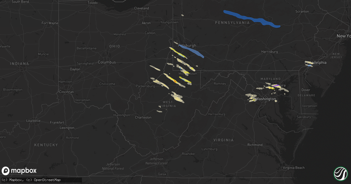
Hail Map in West Virginia on June 14, 2021
Get this storm
June 14 map
$229
one time, instant access
Download today. No call, no setup
Keep the $229
Bought the map and want the full workflow? Apply the entire $229 to a subscription within 7 days. None of it is wasted.
Every map, not just this one
This buys you this map. Subscription and you get every map we run, in the markets you choose from a few cities to whole states to nationwide. Plus real-time alerts the moment a storm fires.
Contact data
Name, contact info, occupancy, even credit band for addresses in the footprint. You go from where it hit to who to call.
Become the source they trust
Unlimited branding weather history reports on demand. You already have the documented answer ready for the property owner, and you are the one who showed up with it.
Property data and RoofTrace estimates
Pull up any address you have got, its value and the exact code rules for that jurisdiction, straight from One Click Code. Then RoofTrace estimates the squares, pitch, and roof value, priced the way you price.
Storm reports in West Virginia
West Virginia
| Date | Description |
|---|---|
| 06/14/20216:50 PM CDT | Several trees down in northern barbour county. Time estimated from radar. |
| 06/14/20216:43 PM CDT | Multiple trees down in the valley chapel area. Pictures provided via facebook. |
| 06/14/20216:37 PM CDT | Trees down on worthington drive |
| 06/14/20216:20 PM CDT | Tree down on windsor dr |
| 06/14/20216:17 PM CDT | Tree down in spelter |
| 06/14/20216:17 PM CDT | Multiple trees down on rock run rd |
| 06/14/20216:13 PM CDT | Multiple reports of lines down in west union. Time estimated from radar. |
| 06/14/20216:12 PM CDT | A local report indicates 1.00 inch wind near ROWLESBURG |
| 06/14/20216:08 PM CDT | Tree reported down on jones run rd |
| 06/14/20216:08 PM CDT | Multiple trees down on river road |
| 06/14/20216:00 PM CDT | Tree down across pruntytown pike. Time estimated from radar. |
| 06/14/20215:58 PM CDT | Tree in power lines along route 119... Locally known as victory avenue... Near mike moser lane. Road closed. Time estimated from radar. |
| 06/14/20215:57 PM CDT | Several trees down on doe run rd |
| 06/14/20215:56 PM CDT | Numerous trees and power lines reported throughout the town and surrounding area. |
| 06/14/20215:55 PM CDT | Tree down on willow lane |
| 06/14/20215:52 PM CDT | Numerous trees and power lines down. Much of the town is without power. |
| 06/14/20215:50 PM CDT | Widespread trees reported down in the fairmont area. |
| 06/14/20215:48 PM CDT | A local report indicates 1.00 inch wind near MORGANTOWN |
| 06/14/20215:46 PM CDT | A local report indicates 1.00 inch wind near TANGLEWOOD |
| 06/14/20215:40 PM CDT | A local report indicates 1.00 inch wind near SUNCREST LAKE |
| 06/14/20214:48 PM CDT | Large number of trees reported downed in and around the town. |
| 06/14/20214:46 PM CDT | Report of large branches and tree limbs down east of moundsville. |
| 06/14/20212:07 PM CDT | A local report indicates 1.00 inch wind near COLLIERS |
| 06/14/20214:54 AM CDT | At 954 PM EDT, a severe thunderstorm was located near Camden On Gauley, or 13 miles northeast of Summersville, moving southeast at 55 mph. HAZARD...60 mph wind gusts and quarter size hail. SOURCE...Radar indicated. IMPACT...Hail damage to vehicles is expected. Expect wind damage to roofs, siding, and trees. Locations impacted include... Richwood, Camden-On-gauley, Camden On Gauley, Craigsville, Cowen, Boggs, Calvin and Upper Glade. |
| 06/14/20214:26 AM CDT | At 926 PM EDT, a severe thunderstorm was located near Clay, moving southeast at 50 mph. HAZARD...60 mph wind gusts and quarter size hail. SOURCE...Radar indicated. IMPACT...Hail damage to vehicles is expected. Expect wind damage to roofs, siding, and trees. Locations impacted include... Summersville, Clay, Camden-On-gauley, Birch River, Craigsville, Big Otter, Camden On Gauley, Wallback, Harrison, Cowen, Widen, Nebo, Strange Creek, Canvas, Muddlety, Nettie, Calvin, Ivydale and Servia.This includes the following highways... Interstate 79 between mile markers 37 and 46. Route 19 between mile markers 37 and 60. |
| 06/14/20213:42 AM CDT | At 841 PM EDT, a severe thunderstorm was located near Rock Cave, or 9 miles southwest of Buckhannon, moving southeast at 50 mph. HAZARD...60 mph wind gusts and nickel size hail. SOURCE...Radar indicated. IMPACT...Expect damage to roofs, siding, and trees. Locations impacted include... Elkins, Buckhannon, Mill Creek, Dailey, Rock Cave, Mingo, Beverly, Womelsdorf (Coalton), Huttonsville, Alexander, Monterville, Lorentz, Glady, Helvetia, Pickens, Alton, Walkersville, Ellamore, Kanawha Head and Tallmansville.This includes Route 33 between mile markers 3 and 32. |
| 06/14/20213:16 AM CDT | At 816 PM EDT, a severe thunderstorm was located near Buckhannon, moving east at 25 mph. HAZARD...60 mph wind gusts and quarter size hail. SOURCE...Radar indicated. IMPACT...Hail damage to vehicles is expected. Expect wind damage to roofs, siding, and trees. Locations impacted include... Buckhannon, Audra State Park, Ellamore, Lorentz, Tallmansville, Overhill and Hodgesville.This includes Route 33 between mile markers 4 and 17. |
| 06/14/20212:58 AM CDT | At 758 PM EDT, a severe thunderstorm was located west of Parsons, moving southeast at 40 mph. HAZARD...Wind gusts to 60 mph. SOURCE...Radar. IMPACT...Expect damage to trees and power lines, resulting in some power outages. Locations impacted include... Parsons... Hendricks... Hambleton... Elk... Pifer Moutain... Davisville... Canaan Valley State Park... Saint George... Pheasant Run... Laneville... Red Creek... |
| 06/14/20212:43 AM CDT | At 743 PM EDT, a severe thunderstorm was located near Philippi, moving southeast at 45 mph. HAZARD...60 mph wind gusts and quarter size hail. SOURCE...Radar indicated. IMPACT...Hail damage to vehicles is expected. Expect wind damage to roofs, siding, and trees. Locations impacted include... Elkins, Grafton, Philippi, Belington, Junior, Montrose, Moatsville, Tygart Lake State Park, Kerens, Galloway and Nestorville.This includes Route 33 between mile markers 33 and 35. |
| 06/14/20212:41 AM CDT | At 741 PM EDT, a severe thunderstorm was located over Jackson Mill, or near Weston, moving southeast at 50 mph. HAZARD...60 mph wind gusts. SOURCE...Radar indicated. IMPACT...Expect damage to roofs, siding, and trees. Locations impacted include... Buckhannon, Weston, Stonewall Jackson, Jackson Mill, Rock Cave, Lost Creek, Jane Lew, Camden, Lorentz, Eden, Alton, Walkersville, Alum Bridge, Kanawha Head, Tallmansville, Overhill, Hodgesville, Horner and French Creek.This includes the following highways... Interstate 79 between mile markers 88 and 109. Route 33 between mile markers 1 and 17. |
| 06/14/20212:34 AM CDT | At 733 PM EDT, a severe thunderstorm was located near North Bend State Park, or near Harrisville, moving southeast at 50 mph. HAZARD...60 mph wind gusts and quarter size hail. SOURCE...Radar indicated. IMPACT...Hail damage to vehicles is expected. Expect wind damage to roofs, siding, and trees. Locations impacted include... Harrisville, Glenville, North Bend State Park, Cedar Creek State Park, Burnsville, Ellenboro, Cairo, Sand Fork, Pullman, Auburn, Smithville, Newberne, Alum Bridge, Big Springs, Berea, Tanner, Burnt House, Baldwin, Nutter Farm and Stouts Mills.This includes the following highways... Interstate 79 between mile markers 76 and 85. Route 50 in West Virginia between mile markers 26 and 37. |
| 06/14/20212:10 AM CDT | At 710 PM EDT, a severe thunderstorm was located over Lumberport, or near Clarksburg, moving southeast at 30 mph. HAZARD...60 mph wind gusts and quarter size hail. SOURCE...Radar indicated. IMPACT...Hail damage to vehicles is expected. Expect wind damage to roofs, siding, and trees. Locations impacted include... Clarksburg, Grafton, Philippi, Bridgeport, Shinnston, Stonewood, Nutter Fort, Lumberport, Anmoore, Flemington, Moatsville, Volga, Rosemont, Meadland, Tygart Lake State Park, Galloway, Meadowbrook and Despard.This includes the following highways... Interstate 79 between mile markers 115 and 128. Route 50 in West Virginia between mile markers 77 and 82. |
| 06/14/20211:57 AM CDT | At 657 PM EDT, a severe thunderstorm was located near Pennsboro, or 9 miles south of Middlebourne, moving southeast at 40 mph. HAZARD...60 mph wind gusts and quarter size hail. SOURCE...Radar indicated. IMPACT...Hail damage to vehicles is expected. Expect wind damage to roofs, siding, and trees. Locations impacted include... Clarksburg, Nutter Fort, Salem, Pennsboro, West Union, Jackson Mill, West Milford, Ellenboro, Alma, Wolf Summit, Alum Bridge, Mountain, Hebron, Center Point, Sedalia, Highland, Camden, Greenwood, Blandville and Avon.This includes Route 50 in West Virginia between mile markers 38 and80. |
| 06/14/20211:54 AM CDT | At 653 PM EDT, a severe thunderstorm was located near Winfield, or near Fairmont, moving east at 40 mph. HAZARD...60 mph wind gusts and quarter size hail. SOURCE...Radar indicated. IMPACT...Hail damage to vehicles is expected. Expect wind damage to roofs, siding, and trees. Locations impacted include... Grafton, Knottsville and Thornton. |
| 06/14/20211:39 AM CDT | At 639 PM EDT, a severe thunderstorm was located over Jacksonburg, or 13 miles west of Mannington, moving southeast at 30 mph. HAZARD...Wind gusts to 60 mph and quarter-size hail. SOURCE...Radar. IMPACT...Minor hail damage to vehicles is possible. Expect wind damage to trees and power lines, resulting in some power outages. Locations impacted include... Pine Grove... Jacksonburg... Smithfield... Big Run... Grangeville... Folsom... |
| 06/14/20211:39 AM CDT | At 639 PM EDT, a severe thunderstorm was located near Jacksonburg, or 13 miles west of Mannington, moving southeast at 40 mph. HAZARD...60 mph wind gusts and quarter size hail. SOURCE...Radar indicated. IMPACT...Hail damage to vehicles is expected. Expect wind damage to roofs, siding, and trees. Locations impacted include... Clarksburg, Bridgeport, Shinnston, Stonewood, Nutter Fort, Lumberport, Anmoore, Enterprise, Wolf Summit, Meadland, Wallace, McGee, Meadowbrook and Despard.This includes the following highways... Interstate 79 between mile markers 112 and 128. Route 50 in West Virginia between mile markers 72 and 82. |
| 06/14/202112:53 AM CDT | At 553 PM EDT, severe thunderstorms were located along a line extending from near Ursina to near Friendsville to 10 miles southwest of Farmington, moving southeast at 35 mph. HAZARD...60 mph wind gusts and quarter size hail. SOURCE...Radar indicated. IMPACT...Damaging winds will cause some trees and large branches to fall. This could injure those outdoors, as well as damage homes and vehicles. Roadways may become blocked by downed trees. Localized power outages are possible. Unsecured light objects may become projectiles. Locations impacted include... Mountain Lake Park, Oakland, Bittinger, Grantsville, Loch Lynn Heights, Friendsville, Deer Park, Accident, Merrill, Keysers Ridge, Jennings, Mineral Spring, Deep Creek Lake State Park, Swallow Falls State Park, McHenry, Selbysport, Big Run State Park, New Germany and McComas Beach. |
| 06/14/202112:18 AM CDT | At 518 PM EDT, a severe thunderstorm was located over Fairdale, or 12 miles east of Waynesburg, moving southeast at 35 mph. HAZARD...Wind gusts to 60 mph. SOURCE...Radar. IMPACT...Expect damage to trees and power lines, resulting in some power outages. Locations impacted include... Morgantown... Uniontown... Masontown... Farmington... Fairdale... Point Marion... Brookhaven... Fairchance... Isabella... Smithfield... Nemacolin... Bobtown...This includes Interstate 68 in West Virginia between mile markers 7and 13. |
| 06/13/20218:58 PM CDT | Trees down on cranberry ridge rd. Time estimated from radar. |
| 06/13/20218:30 PM CDT | Trees down near diana dr. Time estimated from radar. |
| 06/13/20218:00 PM CDT | Picture of one tree down across rt 4 |
| 06/13/20217:50 PM CDT | Tree across the road on route 72 north of parsons. |
| 06/13/20217:50 PM CDT | Picture provided via twitter |
| 06/13/20217:20 PM CDT | Multiple trees down |
| 06/13/20217:15 PM CDT | Tree across the road on route 72 north of parsons. |
| 06/13/20217:12 PM CDT | Tree down across 47 west |
| 06/13/20217:07 PM CDT | Tree down across buckhannon run road near county line. Dispatcher said the call came when the storm started. Time corroborated with radar. |
| 06/13/20217:01 PM CDT | Tree down across beech lick road. Time estimated from radar. |
All States Impacted by Hail Map on June 14, 2021
Cities Impacted by Hail Map on June 14, 2021
- Hamlin, TX
- McCaulley, TX
- Roscoe, TX
- Sylvester, TX
- Sweetwater, TX
- Rotan, TX
- Roby, TX
- Aladdin, WY
- Verbena, AL
- Prattville, AL
- Marbury, AL
- Raleigh, MS
- Moccasin, MT
- Montgomery, AL
- Crowley, TX
- Fort Worth, TX
- Dundalk, MD
- Curtis Bay, MD
- Sparrows Point, MD
- Catonsville, MD
- Baltimore, MD
- Brooklyn, MD
- Gwynn Oak, MD
- Halethorpe, MD
- Sheffield, TX
- Iraan, TX
- Fort Deposit, AL
- Franklin, GA
- Evant, TX
- Star, TX
- Goldthwaite, TX
- Port Lavaca, TX
- Custer, SD
- Wallis, TX
- Sealy, TX
- Roy, MT
- Saint Matthews, SC
- Swansea, SC
- Sonora, TX
- Waynesburg, PA
- Graysville, PA
- Claysville, PA
- West Finley, PA
- Prosperity, PA
- Nineveh, PA
- Sycamore, PA
- Amity, PA
- Mather, PA
- McClellandtown, PA
- Nemacolin, PA
- Ronco, PA
- Carmichaels, PA
- Greensboro, PA
- Clarksville, PA
- Jefferson, PA
- Masontown, PA
- Delanson, NY
- Esperance, NY
- Schoharie, NY
- Lewisville, OH
- Woodsfield, OH
- Horner, WV
- Rock Cave, WV
- Buckhannon, WV
- Adrian, WV
- Walkersville, WV
- Crawford, WV
- French Creek, WV
- Weston, WV
- San Saba, TX
- Lometa, TX
- Lancaster, SC
- Winnsboro, SC
- Great Falls, SC
- Blackstock, SC
- Richburg, SC
- Fort Lawn, SC
- Oral, SD
- Lowndesboro, AL
- Madison, NC
- Walnut Cove, NC
- Victoria, TX
- Bombay, NY
- Moira, NY
- Spraggs, PA
- Mount Morris, PA
- Union Grove, NC
- Harmony, NC
- Juliette, GA
- Forsyth, GA
- Miles, TX
- San Angelo, TX
- Chantilly, VA
- Aldie, VA
- Weston, OR
- Dayton, WA
- Pomeroy, WA
- Waitsburg, WA
- Walla Walla, WA
- Milton Freewater, OR
- Colliers, WV
- Follansbee, WV
- Columbia, MD
- Ellicott City, MD
- Newcastle, WY
- Christoval, TX
- Vancourt, TX
- Weimar, TX
- Hallettsville, TX
- Godley, TX
- Columbia, AL
- Abbeville, AL
- Avella, PA
- Washington, PA
- Lothian, MD
- Harwood, MD
- Saint John, WA
- Endicott, WA
- Brasher Falls, NY
- Roanoke, AL
- Wedowee, AL
- Woodland, AL
- Fort Stockton, TX
- Folsom, WV
- Lumberport, WV
- Jacksonburg, WV
- Wallace, WV
- Smithfield, WV
- Hamilton, TX
- Hico, TX
- Holbrook, PA
- Clarksburg, WV
- Reader, WV
- Pine Grove, WV
- Rushville, NE
- Hay Springs, NE
- Winnett, MT
- Sand Springs, MT
- Roundup, MT
- Mosby, MT
- Ingomar, MT
- Pelzer, SC
- Williamston, SC
- Meridian, TX
- Morgan, TX
- Pine Ridge, SD
- Oelrichs, SD
- Rapid City, SD
- Gainesville, VA
- Catharpin, VA
- Manassas, VA
- Centreville, VA
- Haymarket, VA
- Westford, NY
- Worcester, NY
- Cherry Valley, NY
- Schenevus, NY
- Richfield Springs, NY
- Springfield Center, NY
- Jordanville, NY
- Van Hornesville, NY
- Colton, WA
- Steubenville, OH
- Weirton, WV
- Burgettstown, PA
- Hot Springs, SD
- Cokeburg, PA
- Eighty Four, PA
- Scenery Hill, PA
- Medina, TX
- West Union, WV
- Pennsboro, WV
- Hill City, SD
- Dawsonville, GA
- Smithwick, SD
- Richland Springs, TX
- Headland, AL
- Joshua, TX
- Junction City, GA
- Butler, GA
- Mullin, TX
- Rochelle, TX
- Brookeville, MD
- Glenwood, MD
- Woodbine, MD
- Crawfordville, GA
- Union Point, GA
- Ozona, TX
- Dryden, TX
- Blacksburg, SC
- Kings Mountain, NC
- Cleburne, TX
- Farmington, WV
- Fairmont, WV
- Grafton, WV
- Independence, WV
- Tallmansville, WV
- Preston, GA
- Chadron, NE
- Comstock, TX
- Mohawk, NY
- Maryneal, TX
- Saint Marys, WV
- Newport, OH
- Iredell, TX
- Magee, MS
- Mendenhall, MS
- Baldwin, GA
- Cornelia, GA
- Mount Airy, GA
- Rockwood, TX
- Buffalo Gap, SD
- Barksdale, TX
- Ashburn, VA
- Hookstown, PA
- Clinton, PA
- Rio Vista, TX
- Alvarado, TX
- Grandview, TX
- Covington, TX
- Brandon, MS
- Pelahatchie, MS
- Dale, TX
- Lockhart, TX
- Red Rock, TX
- Morgantown, WV
- Maidsville, WV
- Osage, WV
- Granville, WV
- Pursglove, WV
- Montgomery Village, MD
- Boyds, MD
- Germantown, MD
- Gaithersburg, MD
- Dickerson, MD
- Camden, WV
- Bryan, TX
- Duck, WV
- Rosedale, WV
- Chloe, WV
- Thomaston, AL
- Catherine, AL
- Ernul, NC
- Media, PA
- Glenolden, PA
- Folcroft, PA
- West Chester, PA
- Glen Mills, PA
- Springfield, PA
- Holmes, PA
- Morton, PA
- Drexel Hill, PA
- Malvern, PA
- Clifton Heights, PA
- Broomall, PA
- Lansdowne, PA
- Sharon Hill, PA
- Havertown, PA
- Newtown Square, PA
- Philadelphia, PA
- Darby, PA
- Central, SC
- Loganville, GA
- Conyers, GA
- Oxford, GA
- Elgin, OR
- Autaugaville, AL
- Rock Hall, MD
- Decatur, GA
- Sterling, VA
- Lead, SD
- Sturgis, SD
- Whitewood, SD
- Deadwood, SD
- Spearfish, SD
- Social Circle, GA
- Mansfield, GA
- Bethany, WV
- Valley Grove, WV
- West Alexander, PA
- Laurel, MD
- Bowie, MD
- Selma, AL
- Covington, GA
- Elkridge, MD
- Wind Ridge, PA
- Vineland, NJ
- Bandera, TX
- Homer, GA
- Odenville, AL
- Woodstock, MD
- Marriottsville, MD
- Garwood, TX
- Cameron, WV
- Dallas, WV
- Moundsville, WV
- Lagrange, GA
- Cooperstown, NY
- East Springfield, NY
- Kingston, ID
- Roseboom, NY
- Jane Lew, WV
- Shorter, AL
- Marietta, OH
- New Matamoras, OH
- Reno, OH
- Whipple, OH
- Morton, MS
- Center Point, TX
- Cranfills Gap, TX
- Bruceton Mills, WV
- Farmington, PA
- Gibbon Glade, PA
- Lake Lynn, PA
- Smithfield, PA
- Easley, SC
- Liberty, SC
- Leakey, TX
- Rio Frio, TX
- Stoneboro, PA
- Mercer, PA
- Jackson Center, PA
- Kellogg, ID
- Ellsworth, NE
- Tallassee, AL
- Eclectic, AL
- Sylacauga, AL
- Friendly, WV
- Mocksville, NC
- Clarksville, MD
- Glen Easton, WV
- Millersville, MD
- Odenton, MD
- Gambrills, MD
- Meadville, MS
- Kerrville, TX
- Gilbertown, AL
- Colfax, WA
- Thornton, WA
- Middlebourne, WV
- New Milton, WV
- Dayton, MD
- Commerce, GA
- Carnesville, GA
- Brushton, NY
- Severn, MD
- Del Rio, TX
- Wadley, AL
- Daviston, AL
- Ellenboro, WV
- Bastrop, TX
- Arlington, TX
- Bingham, NE
- Jonesboro, TX
- Uniontown, AL
- Faunsdale, AL
- Sunset, SC
- Graham, AL
- Bowdon, GA
- Roopville, GA
- Billingsley, AL
- Conover, NC
- Stedman, NC
- Wade, NC
- Goliad, TX
- Adger, AL
- Gainesville, GA
- Howes Cave, NY
- Marianna, PA
- Gouldbusk, TX
- Littleton, WV
- Jacksons Gap, AL
- Bluffton, GA
- Cuba, AL
- Ilion, NY
- Fort Plain, NY
- West Winfield, NY
- Crum Lynne, PA
- Woodlyn, PA
- Chester, PA
- Brookhaven, PA
- Gibbstown, NJ
- Barrackville, WV
- Minter, AL
- Ohiopyle, PA
- Chalk Hill, PA
- Comfort, TX
- Imperial, PA
- Forest City, NC
- Mooresboro, NC
- Rutherfordton, NC
- Gillette, WY
- Hayneville, AL
- Cayce, SC
- West Columbia, SC
- Columbia, SC
- Hopkins, SC
- Gaston, SC
- Richland, NJ
- Buena, NJ
- Sutton, WV
- Central Bridge, NY
- Rock Hill, SC
- Hanover, MD
- Lincolnton, GA
- Cobleskill, NY
- Robert Lee, TX
- Clarkesville, GA
- Long Creek, SC
- McCall Creek, MS
- Saint Regis Falls, NY
- Trent, TX
- Lohn, TX
- Glen Burnie, MD
- Pasadena, MD
- Chestertown, MD
- Fort Howard, MD
- Musella, GA
- Macon, GA
- Wallowa, OR
- Stevensville, MD
- Blacksville, WV
- Fairview, WV
- Rogersville, PA
- Dilliner, PA
- Edgemoor, SC
- Catawba, SC
- Aliquippa, PA
- Cooksville, MD
- Sykesville, MD
- Newton, NC
- Claremont, NC
- Brevard, NC
- Rosman, NC
- Gillsville, GA
- Trenton, SC
- Aiken, SC
- Toxey, AL
- Elk, WA
- Newborn, GA
- Blum, TX
- Newhebron, MS
- Sikes, LA
- Osage, WY
- Temple, TX
- New Martinsville, WV
- Shinnston, WV
- Bridgeport, WV
- Meadowbrook, WV
- Porters Falls, WV
- Spelter, WV
- Flemington, WV
- Hepzibah, WV
- Philippi, WV
- Yadkinville, NC
- Booth, AL
- Wesson, MS
- Newville, AL
- Shorterville, AL
- Clarkston, WA
- Granbury, TX
- Salem, SC
- Tamassee, SC
- Walhalla, SC
- Clanton, AL
- Windsor Mill, MD
- Six Mile, SC
- Richmondville, NY
- Lamont, WA
- Hampton, GA
- Locust Grove, GA
- Glenelg, MD
- Eagle Lake, TX
- Cheney, WA
- Tunnelton, WV
- Newburg, WV
- Thornton, WV
- Goodwater, AL
- Toccoa, GA
- Palacios, TX
- Helvetia, WV
- Purcellville, VA
- Leesburg, VA
- Herndon, VA
- Clifton, VA
- Middleburg, VA
- Fairfax, VA
- Doole, TX
- Nordman, ID
- Grass Range, MT
- Atlanta, GA
- Fairburn, GA
- Ward, AL
- Summerfield, OH
- Senecaville, OH
- Columbus, TX
- Robstown, TX
- Chattaroy, WA
- Bronte, TX
- Fulshear, TX
- Coal Center, PA
- Bentleyville, PA
- Daisytown, PA
- Ellsworth, PA
- Hickory, PA
- Crystal Springs, MS
- Harrisville, MS
- Florence, MS
- Sloansville, NY
- Davenport, WA
- Newport, WA
- Thornton, PA
- Swedesboro, NJ
- Essington, PA
- Chester Heights, PA
- Wallingford, PA
- Ridley Park, PA
- Garnet Valley, PA
- Aston, PA
- Alum Bridge, WV
- Ivydale, WV
- Clay, WV
- Wallback, WV
- Hulett, WY
- Arvada, WY
- Recluse, WY
- Ormond Beach, FL
- Bunnell, FL
- Palm Coast, FL
- Flagler Beach, FL
- Linthicum Heights, MD
- Austwell, TX
- Tivoli, TX
- Seadrift, TX
- Canajoharie, NY
- Saint Marys, PA
- Northumberland, PA
- Driftwood, PA
- Allenwood, PA
- Bloomsburg, PA
- Kersey, PA
- New Columbia, PA
- Weedville, PA
- Mifflinburg, PA
- Williamsport, PA
- Riverside, PA
- Jersey Shore, PA
- Mill Hall, PA
- Benezett, PA
- Beech Creek, PA
- Loganton, PA
- Lock Haven, PA
- White Deer, PA
- Pottersdale, PA
- Watsontown, PA
- McEwensville, PA
- Danville, PA
- Sinnamahoning, PA
- Linden, PA
- Karthaus, PA
- Westport, PA
- Lewisburg, PA
- Renovo, PA
- Milton, PA
- Avis, PA
- Mount Pleasant, PA
- Buena Vista, PA
- Madison, PA
- Glassport, PA
- McDonald, PA
- Acme, PA
- Jones Mills, PA
- Coraopolis, PA
- Adamsburg, PA
- Elizabeth, PA
- Dravosburg, PA
- Stahlstown, PA
- Carnegie, PA
- West Newton, PA
- Yukon, PA
- West Mifflin, PA
- Arona, PA
- Irwin, PA
- Greenock, PA
- New Stanton, PA
- Bridgeville, PA
- Youngwood, PA
- Champion, PA
- Tarrs, PA
- Donegal, PA
- Bethel Park, PA
- Darragh, PA
- Oakdale, PA
- Rillton, PA
- Jeannette, PA
- Pittsburgh, PA
- Clairton, PA
- Presto, PA
- Herminie, PA
- Ruffs Dale, PA
- Hunker, PA
- Mckeesport, PA
- Greensburg, PA
- Swarthmore, PA
- Marcus Hook, PA
- Folsom, PA


