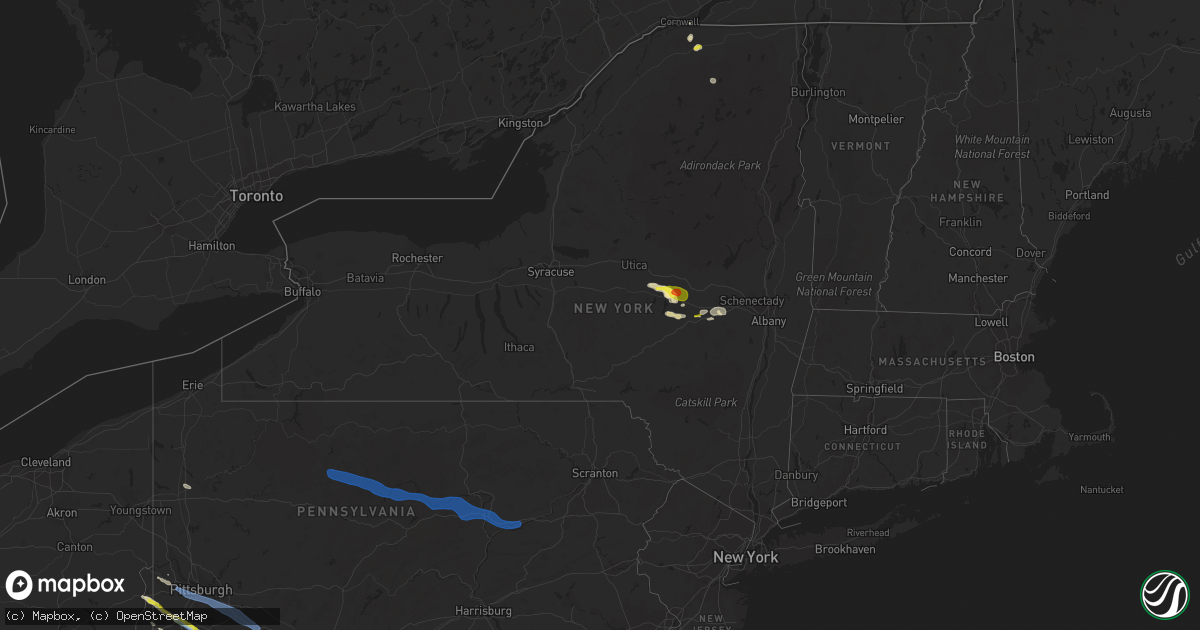
Hail Map in New York on June 14, 2021
Get this storm
June 14 map
$229
one time, instant access
Download today. No call, no setup
Keep the $229
Bought the map and want the full workflow? Apply the entire $229 to a subscription within 7 days. None of it is wasted.
Every map, not just this one
This buys you this map. Subscription and you get every map we run, in the markets you choose from a few cities to whole states to nationwide. Plus real-time alerts the moment a storm fires.
Contact data
Name, contact info, occupancy, even credit band for addresses in the footprint. You go from where it hit to who to call.
Become the source they trust
Unlimited branding weather history reports on demand. You already have the documented answer ready for the property owner, and you are the one who showed up with it.
Property data and RoofTrace estimates
Pull up any address you have got, its value and the exact code rules for that jurisdiction, straight from One Click Code. Then RoofTrace estimates the squares, pitch, and roof value, priced the way you price.
Storm reports in New York
New York
| Date | Description |
|---|---|
| 06/14/20213:50 PM CDT | Nickel to quarter size hail at the intersection of lowe road and route 10 |
| 06/14/20213:06 PM CDT | Quarter size hail reported in moira. |
| 06/14/20213:02 PM CDT | Dime to quarter size hail reported in brushton. |
| 06/14/20212:00 PM CDT | Quarter to golf ball size hail at the corner of gros road and jordan road. |
| 06/14/20217:18 AM CDT | At 1218 AM EDT, a severe thunderstorm was located over Camillus, or 7 miles south of Baldwinsville, moving east at 30 mph. HAZARD...60 mph wind gusts and quarter size hail. SOURCE...Radar indicated. IMPACT...Hail damage to vehicles is expected. Expect wind damage to roofs, siding, and trees. This severe thunderstorm will be near... New York State Fairgrounds around 1230 AM EDT. Syracuse, Liverpool and Galeville around 1235 AM EDT. Cicero around 1240 AM EDT. Manlius, Lyndon and Kirkville around 1245 AM EDT. |
| 06/14/20217:04 AM CDT | At 1203 AM EDT, severe thunderstorms were located along a line extending from near Dexter to near Adams, moving east at 40 mph. HAZARD...60 mph wind gusts and quarter size hail. SOURCE...Radar indicated. IMPACT...Minor damage to vehicles is possible. Expect wind damage to roofs, siding, and trees. Locations impacted include... Watertown, Fort Drum, Carthage, Lowville, West Carthage, Adams, Dexter, Glen Park, Herrings and Adams Center. This includes Interstate 81 between exits 39 and 49. |
| 06/14/20216:12 AM CDT | At 1111 AM EDT, a severe thunderstorm was located over Central Bridge, or 9 miles northeast of Cobleskill, moving east at 20 mph. HAZARD...60 mph wind gusts and quarter size hail. SOURCE...Radar indicated. IMPACT...Hail damage to vehicles is expected. Expect wind damage to roofs, siding, and trees. Locations impacted include... Schenectady, Rotterdam, Scotia, Guilderland, Glenville, Duanesburg, Altamont, Schoharie, Delanson, Rotterdam Junction, Central Bridge, Pattersonville-Rotterdam Junction, Knox, Princetown, Esperance, Duane, Hoffmans, Rockwell Corners, Harding Crossing and Gifford. |
| 06/14/20211:48 AM CDT | At 647 PM EDT, severe thunderstorms were located along a line extending from near Unionville to near Franklin to near Hopatcong to near Long Valley, moving east at 45 mph. HAZARD...60 mph wind gusts. SOURCE...Radar indicated. IMPACT...Damage to roofs, siding, trees, and power lines is possible. Locations impacted include... Morristown, Dover, Madison, Hopatcong, Florham Park, East Hanover, Lincoln Park, Kinnelon, Chatham, Boonton, Butler, Wharton, Rockaway, Morris Plains, Mount Arlington, Franklin, Mendham, Mountain Lakes, Stanhope and Riverdale.People at the Morris County Mega Site should seek safe shelterimmediately!This includes the following highways... Interstate 80 in New Jersey between mile markers 26 and 48. Interstate 287 in New Jersey between mile markers 26 and 54. |
| 06/14/202112:38 AM CDT | At 538 PM EDT, a severe thunderstorm was located over Thompsonville, or near Monticello, moving east at 20 mph. HAZARD...60 mph wind gusts and quarter size hail. SOURCE...Radar indicated. IMPACT...Hail damage to vehicles is expected. Expect wind damage to roofs, siding, and trees. Locations impacted include... Fallsburg, South Fallsburg, Woodridge, Phillipsport, Thompsonville, Rock Hill, Woodbourne, Spring Glen, Mountain Dale and Mt Vernon. |
| 06/14/202112:02 AM CDT | At 501 PM EDT, a severe thunderstorm was located over Roxbury, or 17 miles west of Hunter, moving east at 35 mph. HAZARD...60 mph wind gusts and quarter size hail. SOURCE...Radar indicated. IMPACT...Hail damage to vehicles is expected. Expect wind damage to roofs, siding, and trees. Locations impacted include... New Baltimore, Westerlo, Ravena, Coxsackie, Windham, Gilboa, Prattsville, Preston-Potter Hollow, Feura Bush, Preston Hollow, Selkirk, Coeymans, Cairo, Durham, Ashland, Jewett, Lexington, Conesville, Coeymans Hollow and West Settlement. |
| 06/13/202111:17 PM CDT | At 417 PM EDT, a severe thunderstorm was located near Middlefield, or 9 miles east of Cooperstown, moving east at 25 mph. HAZARD...Ping pong ball size hail and 60 mph wind gusts. SOURCE...Radar indicated. IMPACT...People and animals outdoors will be injured. Expect hail damage to roofs, siding, windows, and vehicles. Expect wind damage to roofs, siding, and trees. Locations impacted include... Cobleskill, Middleburgh, Summit, Schoharie, Richmondville, Sharon Springs, Livingstonville, Breakabeen, Central Bridge, North Blenheim, Preston-Potter Hollow, Carlisle, Sharon, Seward, Zeh Corners, Beekman Corners, West Richmondville, Huntersland, Warnerville and Gardnersville. |
| 06/13/202110:57 PM CDT | At 356 PM EDT, a severe thunderstorm was located over Brushton, moving northeast at 10 mph. HAZARD...60 mph wind gusts and quarter size hail. SOURCE...Radar indicated. IMPACT...Minor hail damage to vehicles is possible. Expect wind damage to trees and powerlines. Locations impacted include... Moira, Fort Covington, Bombay, Brushton, Westville Center, Fort Covington Center and South Bombay. |
| 06/13/202110:55 PM CDT | At 355 PM EDT, a severe thunderstorm was located over Bowerstown, or over Cooperstown, moving east at 15 mph. HAZARD...60 mph wind gusts and quarter size hail. SOURCE...Radar indicated. IMPACT...Hail damage to vehicles is expected. Expect wind damage to roofs, siding, and trees. Locations impacted include... Middlefield, Hartwick, Cooperstown, Westville, Westford, Cherry Valley, Milford, Bowerstown, Elk Creek and Oaksville. |
| 06/13/202110:30 PM CDT | At 330 PM EDT, a severe thunderstorm was located over Cherry Valley, or 10 miles northeast of Cooperstown, moving east at 20 mph. HAZARD...60 mph wind gusts and quarter size hail. SOURCE...Radar indicated. IMPACT...Hail damage to vehicles is expected. Expect wind damage to roofs, siding, and trees. Locations impacted include... Springfield, Cherry Valley, Glimmerglass State Park, East Springfield and Salt Springville. |
| 06/13/20219:53 PM CDT | At 252 PM EDT, a severe thunderstorm was located near Springfield, or 10 miles south of Little Falls, moving east at 35 mph. HAZARD...60 mph wind gusts and quarter size hail. SOURCE...Radar indicated. IMPACT...Hail damage to vehicles is expected. Expect wind damage to roofs, siding, and trees. Locations impacted include... Amsterdam, Gloversville, Johnstown, Canajoharie, Fonda, Fort Plain, St. Johnsville, Ephratah, Broadalbin, Hagaman, Fort Johnson, Ames, Tribes Hill, Perth, Glen, Charleston, Fultonville, Palatine Bridge, Nelliston and West Perth. |
| 06/13/20219:53 PM CDT | At 253 PM EDT, a severe thunderstorm was located over Oneida, moving east at 20 mph. HAZARD...60 mph wind gusts and penny size hail. SOURCE...Radar indicated. IMPACT...Expect damage to roofs, siding, and trees. Locations impacted include... Rome, Oneida, Lenox, Verona, Westmoreland, Sherrill, Stockbridge, Augusta, Vernon and Oneida Castle. |
| 06/13/20219:47 PM CDT | At 247 PM EDT, a severe thunderstorm was located over Springfield, or 11 miles south of Little Falls, moving east at 25 mph. HAZARD...60 mph wind gusts and penny size hail. SOURCE...Radar indicated. IMPACT...Expect damage to roofs, siding, and trees. Locations impacted include... Springfield, Cherry Valley, Salt Springville, Glimmerglass State Park and East Springfield. |
| 06/13/20219:18 PM CDT | At 218 PM EDT, a severe thunderstorm was located near Cedarville, or near Ilion, moving northeast at 30 mph. HAZARD...60 mph wind gusts and quarter size hail. SOURCE...Radar indicated. IMPACT...Hail damage to vehicles is expected. Expect wind damage to roofs, siding, and trees. Locations impacted include... Ilion, Herkimer, Little Falls, Mohawk, Frankfort, Dolgeville, St. Johnsville, Stratford, Jordanville, Caroga Lake, Caroga Lake Public Campground, Cedarville, Oppenheim, Elizabethtown, Ingham Mills, Spinnerville, South Ilion, Mindenville, Kelhi Corners and Chepachet. |
| 06/13/20218:41 PM CDT | At 141 AM EDT, severe thunderstorms were located along a line extending from near Boonville to near Waterville, moving east at 40 mph. HAZARD...60 mph wind gusts. SOURCE...Radar indicated. IMPACT...Expect damage to roofs, siding, and trees. Locations impacted include... Utica, Rome, Kirkland, Westmoreland, Trenton, Paris, Deerfield, Floyd, Whitesboro and New York Mills. |
| 06/13/20218:08 PM CDT | At 108 AM EDT, a severe thunderstorm was located over Canastota, or near Oneida, moving east at 40 mph. HAZARD...60 mph wind gusts and quarter size hail. SOURCE...Radar indicated. IMPACT...Hail damage to vehicles is expected. Expect wind damage to roofs, siding, and trees. Locations impacted include... Utica, Sullivan, Oneida, Kirkland, Lenox, Verona, Westmoreland, Chittenango, Canastota and Manlius. |
| 06/13/20218:00 PM CDT | At 100 AM EDT, severe thunderstorms were located along a line extending from 8 miles southwest of Highmarket to near Rome, moving east at 25 mph. HAZARD...60 mph wind gusts. SOURCE...Radar indicated. IMPACT...Expect damage to roofs, siding, and trees. Severe thunderstorms will be near... Delta Lake around 110 AM EDT. Rome around 115 AM EDT. Floyd and Oriskany around 120 AM EDT. Stittville around 130 AM EDT. Holland Patent around 135 AM EDT. Boonville around 140 AM EDT. Trenton, Forestport and Trenton Falls around 145 AM EDT. |
All States Impacted by Hail Map on June 14, 2021
Cities Impacted by Hail Map on June 14, 2021
- Hamlin, TX
- McCaulley, TX
- Roscoe, TX
- Sylvester, TX
- Sweetwater, TX
- Rotan, TX
- Roby, TX
- Aladdin, WY
- Verbena, AL
- Prattville, AL
- Marbury, AL
- Raleigh, MS
- Moccasin, MT
- Montgomery, AL
- Crowley, TX
- Fort Worth, TX
- Dundalk, MD
- Curtis Bay, MD
- Sparrows Point, MD
- Catonsville, MD
- Baltimore, MD
- Brooklyn, MD
- Gwynn Oak, MD
- Halethorpe, MD
- Sheffield, TX
- Iraan, TX
- Fort Deposit, AL
- Franklin, GA
- Evant, TX
- Star, TX
- Goldthwaite, TX
- Port Lavaca, TX
- Custer, SD
- Wallis, TX
- Sealy, TX
- Roy, MT
- Saint Matthews, SC
- Swansea, SC
- Sonora, TX
- Waynesburg, PA
- Graysville, PA
- Claysville, PA
- West Finley, PA
- Prosperity, PA
- Nineveh, PA
- Sycamore, PA
- Amity, PA
- Mather, PA
- McClellandtown, PA
- Nemacolin, PA
- Ronco, PA
- Carmichaels, PA
- Greensboro, PA
- Clarksville, PA
- Jefferson, PA
- Masontown, PA
- Delanson, NY
- Esperance, NY
- Schoharie, NY
- Lewisville, OH
- Woodsfield, OH
- Horner, WV
- Rock Cave, WV
- Buckhannon, WV
- Adrian, WV
- Walkersville, WV
- Crawford, WV
- French Creek, WV
- Weston, WV
- San Saba, TX
- Lometa, TX
- Lancaster, SC
- Winnsboro, SC
- Great Falls, SC
- Blackstock, SC
- Richburg, SC
- Fort Lawn, SC
- Oral, SD
- Lowndesboro, AL
- Madison, NC
- Walnut Cove, NC
- Victoria, TX
- Bombay, NY
- Moira, NY
- Spraggs, PA
- Mount Morris, PA
- Union Grove, NC
- Harmony, NC
- Juliette, GA
- Forsyth, GA
- Miles, TX
- San Angelo, TX
- Chantilly, VA
- Aldie, VA
- Weston, OR
- Dayton, WA
- Pomeroy, WA
- Waitsburg, WA
- Walla Walla, WA
- Milton Freewater, OR
- Colliers, WV
- Follansbee, WV
- Columbia, MD
- Ellicott City, MD
- Newcastle, WY
- Christoval, TX
- Vancourt, TX
- Weimar, TX
- Hallettsville, TX
- Godley, TX
- Columbia, AL
- Abbeville, AL
- Avella, PA
- Washington, PA
- Lothian, MD
- Harwood, MD
- Saint John, WA
- Endicott, WA
- Brasher Falls, NY
- Roanoke, AL
- Wedowee, AL
- Woodland, AL
- Fort Stockton, TX
- Folsom, WV
- Lumberport, WV
- Jacksonburg, WV
- Wallace, WV
- Smithfield, WV
- Hamilton, TX
- Hico, TX
- Holbrook, PA
- Clarksburg, WV
- Reader, WV
- Pine Grove, WV
- Rushville, NE
- Hay Springs, NE
- Winnett, MT
- Sand Springs, MT
- Roundup, MT
- Mosby, MT
- Ingomar, MT
- Pelzer, SC
- Williamston, SC
- Meridian, TX
- Morgan, TX
- Pine Ridge, SD
- Oelrichs, SD
- Rapid City, SD
- Gainesville, VA
- Catharpin, VA
- Manassas, VA
- Centreville, VA
- Haymarket, VA
- Westford, NY
- Worcester, NY
- Cherry Valley, NY
- Schenevus, NY
- Richfield Springs, NY
- Springfield Center, NY
- Jordanville, NY
- Van Hornesville, NY
- Colton, WA
- Steubenville, OH
- Weirton, WV
- Burgettstown, PA
- Hot Springs, SD
- Cokeburg, PA
- Eighty Four, PA
- Scenery Hill, PA
- Medina, TX
- West Union, WV
- Pennsboro, WV
- Hill City, SD
- Dawsonville, GA
- Smithwick, SD
- Richland Springs, TX
- Headland, AL
- Joshua, TX
- Junction City, GA
- Butler, GA
- Mullin, TX
- Rochelle, TX
- Brookeville, MD
- Glenwood, MD
- Woodbine, MD
- Crawfordville, GA
- Union Point, GA
- Ozona, TX
- Dryden, TX
- Blacksburg, SC
- Kings Mountain, NC
- Cleburne, TX
- Farmington, WV
- Fairmont, WV
- Grafton, WV
- Independence, WV
- Tallmansville, WV
- Preston, GA
- Chadron, NE
- Comstock, TX
- Mohawk, NY
- Maryneal, TX
- Saint Marys, WV
- Newport, OH
- Iredell, TX
- Magee, MS
- Mendenhall, MS
- Baldwin, GA
- Cornelia, GA
- Mount Airy, GA
- Rockwood, TX
- Buffalo Gap, SD
- Barksdale, TX
- Ashburn, VA
- Hookstown, PA
- Clinton, PA
- Rio Vista, TX
- Alvarado, TX
- Grandview, TX
- Covington, TX
- Brandon, MS
- Pelahatchie, MS
- Dale, TX
- Lockhart, TX
- Red Rock, TX
- Morgantown, WV
- Maidsville, WV
- Osage, WV
- Granville, WV
- Pursglove, WV
- Montgomery Village, MD
- Boyds, MD
- Germantown, MD
- Gaithersburg, MD
- Dickerson, MD
- Camden, WV
- Bryan, TX
- Duck, WV
- Rosedale, WV
- Chloe, WV
- Thomaston, AL
- Catherine, AL
- Ernul, NC
- Media, PA
- Glenolden, PA
- Folcroft, PA
- West Chester, PA
- Glen Mills, PA
- Springfield, PA
- Holmes, PA
- Morton, PA
- Drexel Hill, PA
- Malvern, PA
- Clifton Heights, PA
- Broomall, PA
- Lansdowne, PA
- Sharon Hill, PA
- Havertown, PA
- Newtown Square, PA
- Philadelphia, PA
- Darby, PA
- Central, SC
- Loganville, GA
- Conyers, GA
- Oxford, GA
- Elgin, OR
- Autaugaville, AL
- Rock Hall, MD
- Decatur, GA
- Sterling, VA
- Lead, SD
- Sturgis, SD
- Whitewood, SD
- Deadwood, SD
- Spearfish, SD
- Social Circle, GA
- Mansfield, GA
- Bethany, WV
- Valley Grove, WV
- West Alexander, PA
- Laurel, MD
- Bowie, MD
- Selma, AL
- Covington, GA
- Elkridge, MD
- Wind Ridge, PA
- Vineland, NJ
- Bandera, TX
- Homer, GA
- Odenville, AL
- Woodstock, MD
- Marriottsville, MD
- Garwood, TX
- Cameron, WV
- Dallas, WV
- Moundsville, WV
- Lagrange, GA
- Cooperstown, NY
- East Springfield, NY
- Kingston, ID
- Roseboom, NY
- Jane Lew, WV
- Shorter, AL
- Marietta, OH
- New Matamoras, OH
- Reno, OH
- Whipple, OH
- Morton, MS
- Center Point, TX
- Cranfills Gap, TX
- Bruceton Mills, WV
- Farmington, PA
- Gibbon Glade, PA
- Lake Lynn, PA
- Smithfield, PA
- Easley, SC
- Liberty, SC
- Leakey, TX
- Rio Frio, TX
- Stoneboro, PA
- Mercer, PA
- Jackson Center, PA
- Kellogg, ID
- Ellsworth, NE
- Tallassee, AL
- Eclectic, AL
- Sylacauga, AL
- Friendly, WV
- Mocksville, NC
- Clarksville, MD
- Glen Easton, WV
- Millersville, MD
- Odenton, MD
- Gambrills, MD
- Meadville, MS
- Kerrville, TX
- Gilbertown, AL
- Colfax, WA
- Thornton, WA
- Middlebourne, WV
- New Milton, WV
- Dayton, MD
- Commerce, GA
- Carnesville, GA
- Brushton, NY
- Severn, MD
- Del Rio, TX
- Wadley, AL
- Daviston, AL
- Ellenboro, WV
- Bastrop, TX
- Arlington, TX
- Bingham, NE
- Jonesboro, TX
- Uniontown, AL
- Faunsdale, AL
- Sunset, SC
- Graham, AL
- Bowdon, GA
- Roopville, GA
- Billingsley, AL
- Conover, NC
- Stedman, NC
- Wade, NC
- Goliad, TX
- Adger, AL
- Gainesville, GA
- Howes Cave, NY
- Marianna, PA
- Gouldbusk, TX
- Littleton, WV
- Jacksons Gap, AL
- Bluffton, GA
- Cuba, AL
- Ilion, NY
- Fort Plain, NY
- West Winfield, NY
- Crum Lynne, PA
- Woodlyn, PA
- Chester, PA
- Brookhaven, PA
- Gibbstown, NJ
- Barrackville, WV
- Minter, AL
- Ohiopyle, PA
- Chalk Hill, PA
- Comfort, TX
- Imperial, PA
- Forest City, NC
- Mooresboro, NC
- Rutherfordton, NC
- Gillette, WY
- Hayneville, AL
- Cayce, SC
- West Columbia, SC
- Columbia, SC
- Hopkins, SC
- Gaston, SC
- Richland, NJ
- Buena, NJ
- Sutton, WV
- Central Bridge, NY
- Rock Hill, SC
- Hanover, MD
- Lincolnton, GA
- Cobleskill, NY
- Robert Lee, TX
- Clarkesville, GA
- Long Creek, SC
- McCall Creek, MS
- Saint Regis Falls, NY
- Trent, TX
- Lohn, TX
- Glen Burnie, MD
- Pasadena, MD
- Chestertown, MD
- Fort Howard, MD
- Musella, GA
- Macon, GA
- Wallowa, OR
- Stevensville, MD
- Blacksville, WV
- Fairview, WV
- Rogersville, PA
- Dilliner, PA
- Edgemoor, SC
- Catawba, SC
- Aliquippa, PA
- Cooksville, MD
- Sykesville, MD
- Newton, NC
- Claremont, NC
- Brevard, NC
- Rosman, NC
- Gillsville, GA
- Trenton, SC
- Aiken, SC
- Toxey, AL
- Elk, WA
- Newborn, GA
- Blum, TX
- Newhebron, MS
- Sikes, LA
- Osage, WY
- Temple, TX
- New Martinsville, WV
- Shinnston, WV
- Bridgeport, WV
- Meadowbrook, WV
- Porters Falls, WV
- Spelter, WV
- Flemington, WV
- Hepzibah, WV
- Philippi, WV
- Yadkinville, NC
- Booth, AL
- Wesson, MS
- Newville, AL
- Shorterville, AL
- Clarkston, WA
- Granbury, TX
- Salem, SC
- Tamassee, SC
- Walhalla, SC
- Clanton, AL
- Windsor Mill, MD
- Six Mile, SC
- Richmondville, NY
- Lamont, WA
- Hampton, GA
- Locust Grove, GA
- Glenelg, MD
- Eagle Lake, TX
- Cheney, WA
- Tunnelton, WV
- Newburg, WV
- Thornton, WV
- Goodwater, AL
- Toccoa, GA
- Palacios, TX
- Helvetia, WV
- Purcellville, VA
- Leesburg, VA
- Herndon, VA
- Clifton, VA
- Middleburg, VA
- Fairfax, VA
- Doole, TX
- Nordman, ID
- Grass Range, MT
- Atlanta, GA
- Fairburn, GA
- Ward, AL
- Summerfield, OH
- Senecaville, OH
- Columbus, TX
- Robstown, TX
- Chattaroy, WA
- Bronte, TX
- Fulshear, TX
- Coal Center, PA
- Bentleyville, PA
- Daisytown, PA
- Ellsworth, PA
- Hickory, PA
- Crystal Springs, MS
- Harrisville, MS
- Florence, MS
- Sloansville, NY
- Davenport, WA
- Newport, WA
- Thornton, PA
- Swedesboro, NJ
- Essington, PA
- Chester Heights, PA
- Wallingford, PA
- Ridley Park, PA
- Garnet Valley, PA
- Aston, PA
- Alum Bridge, WV
- Ivydale, WV
- Clay, WV
- Wallback, WV
- Hulett, WY
- Arvada, WY
- Recluse, WY
- Ormond Beach, FL
- Bunnell, FL
- Palm Coast, FL
- Flagler Beach, FL
- Linthicum Heights, MD
- Austwell, TX
- Tivoli, TX
- Seadrift, TX
- Canajoharie, NY
- Saint Marys, PA
- Northumberland, PA
- Driftwood, PA
- Allenwood, PA
- Bloomsburg, PA
- Kersey, PA
- New Columbia, PA
- Weedville, PA
- Mifflinburg, PA
- Williamsport, PA
- Riverside, PA
- Jersey Shore, PA
- Mill Hall, PA
- Benezett, PA
- Beech Creek, PA
- Loganton, PA
- Lock Haven, PA
- White Deer, PA
- Pottersdale, PA
- Watsontown, PA
- McEwensville, PA
- Danville, PA
- Sinnamahoning, PA
- Linden, PA
- Karthaus, PA
- Westport, PA
- Lewisburg, PA
- Renovo, PA
- Milton, PA
- Avis, PA
- Mount Pleasant, PA
- Buena Vista, PA
- Madison, PA
- Glassport, PA
- McDonald, PA
- Acme, PA
- Jones Mills, PA
- Coraopolis, PA
- Adamsburg, PA
- Elizabeth, PA
- Dravosburg, PA
- Stahlstown, PA
- Carnegie, PA
- West Newton, PA
- Yukon, PA
- West Mifflin, PA
- Arona, PA
- Irwin, PA
- Greenock, PA
- New Stanton, PA
- Bridgeville, PA
- Youngwood, PA
- Champion, PA
- Tarrs, PA
- Donegal, PA
- Bethel Park, PA
- Darragh, PA
- Oakdale, PA
- Rillton, PA
- Jeannette, PA
- Pittsburgh, PA
- Clairton, PA
- Presto, PA
- Herminie, PA
- Ruffs Dale, PA
- Hunker, PA
- Mckeesport, PA
- Greensburg, PA
- Swarthmore, PA
- Marcus Hook, PA
- Folsom, PA


