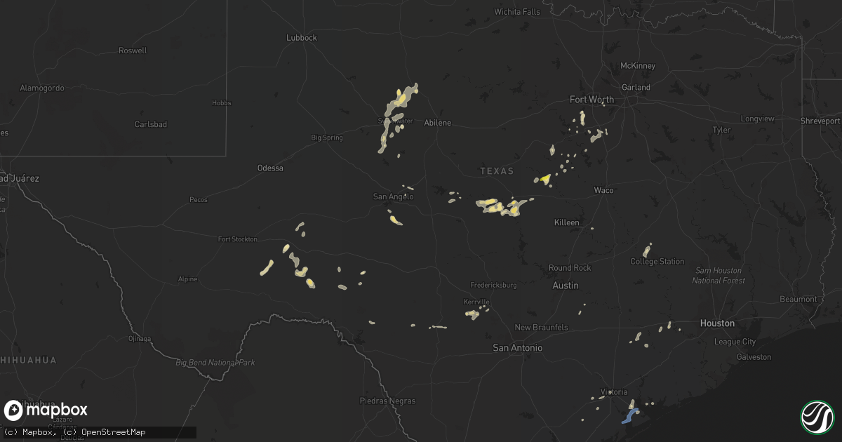
Hail Map in Texas on June 14, 2021
Get this storm
June 14 map
$229
one time, instant access
Download today. No call, no setup
Keep the $229
Bought the map and want the full workflow? Apply the entire $229 to a subscription within 7 days. None of it is wasted.
Every map, not just this one
This buys you this map. Subscription and you get every map we run, in the markets you choose from a few cities to whole states to nationwide. Plus real-time alerts the moment a storm fires.
Contact data
Name, contact info, occupancy, even credit band for addresses in the footprint. You go from where it hit to who to call.
Become the source they trust
Unlimited branding weather history reports on demand. You already have the documented answer ready for the property owner, and you are the one who showed up with it.
Property data and RoofTrace estimates
Pull up any address you have got, its value and the exact code rules for that jurisdiction, straight from One Click Code. Then RoofTrace estimates the squares, pitch, and roof value, priced the way you price.
Storm reports in Texas
Texas
| Date | Description |
|---|---|
| 06/14/20216:55 PM CDT | Damage to a carport at a residence on sherrill road; personal weather station at the residence also indicated a maximum wind gust around 65 mph. Time estimated via rada |
| 06/14/20216:54 PM CDT | Tree branches down. |
| 06/14/20216:49 PM CDT | Tree fell onto roof of garage. |
| 06/14/20216:26 PM CDT | Near west 2nd street and jackson street...roof and awning damage to several buildings. Other reports of trees down and roof damage around beeville as well. 626-700 pm c |
| 06/14/20216:02 PM CDT | Significant structural damage on side of building at the grace temple church in goliad. |
| 06/14/20215:48 PM CDT | 1-inch tree limbs broken; shingles blown off. |
| 06/14/20215:30 PM CDT | Several power poles down. |
| 06/14/20215:21 PM CDT | Fire department reports quarter size hail just out of hamilton on state highway 36. |
| 06/14/20215:16 PM CDT | Gusts estimated near 60 mph. |
| 06/14/20215:01 PM CDT | Mesonet station dw8849 port lavaca. |
| 06/14/20214:58 PM CDT | Multiple 3 to 6 inch tree limbs down... Heavy machinery in yard moved. |
| 06/14/20213:40 PM CDT | Wind turbine damaged. |
| 06/14/20213:18 PM CDT | Trees blown down. |
| 06/14/20218:15 AM CDT | Skywarn spotter reports multiple power poles and large trees down in sweetwater... Tx. |
| 06/14/20218:00 AM CDT | Delayed report from social media of a large tree that was mostly uprooted and knocked over. |
| 06/14/20217:19 AM CDT | At 1219 AM CDT, a severe thunderstorm was located near Marshall, and is nearly stationary. HAZARD...60 mph wind gusts. SOURCE...Radar indicated. IMPACT...Expect damage to roofs, siding, and trees. Locations impacted include... Marshall, Hallsville, Nesbitt and Darco. |
| 06/14/20213:51 AM CDT | At 849 PM CDT, a severe thunderstorm was located near Christoval, moving northwest at 25 mph. HAZARD...60 mph wind gusts and quarter size hail. SOURCE...Radar indicated. IMPACT...Hail damage to vehicles is expected. Expect wind damage to roofs, siding, and trees. This severe thunderstorm will be near... Christoval around 900 PM CDT. Knickerbocker and Tankersley around 920 PM CDT.Other locations impacted by this severe thunderstorm include Us-67 Near The Irion-Tom Green County Line. |
| 06/14/20213:28 AM CDT | At 828 AM CDT, a severe thunderstorm was located over Maryneal, moving south at 35 mph. HAZARD...60 mph wind gusts. SOURCE...Radar indicated. IMPACT...Expect damage to roofs, siding, and trees. This severe thunderstorm will be near... Sanco around 855 AM CDT. Robert Lee and E.V. Spence Reservoir Near Paint Creek Recreation Area around 905 AM CDT.Other locations impacted by this severe thunderstorm include TheIntersection Of Highway 208 And Ranch Road 2662, The Intersection OfHighway 158 And Ranch Road 2059, The Intersection Of Highway 70 AndRanch Road 53 and The Intersection Of Ranch Road 608 And Highway 147. |
| 06/14/20213:16 AM CDT | At 816 PM CDT, a severe thunderstorm was located 9 miles northwest of Bishop, or 10 miles northwest of Kingsville, moving southwest at 25 mph. HAZARD...60 mph wind gusts and nickel size hail. SOURCE...Radar indicated. IMPACT...Expect damage to roofs, siding, and trees. Locations impacted include... Kingsville, Premont, Bishop, Ben Bolt and Ricardo. This includes the following highways... US Highway 281 between mile markers 680 and 700. US Highway 77 between mile markers 690 and 700. |
| 06/14/20212:50 AM CDT | At 750 PM CDT, a severe thunderstorm was located over Banquete, or 9 miles west of Robstown, moving southwest at 10 mph. HAZARD...60 mph wind gusts and nickel size hail. SOURCE...Radar indicated. IMPACT...Expect damage to roofs, siding, and trees. Locations impacted include... Kingsville, Alice, Robstown, Driscoll, Bishop, Alice Acres, Banquete, Kingsville Naval Air Station, Agua Dulce, Lake Alice and North San Pedro.This includes the following highways... US Highway 281 between mile markers 672 and 678. US Highway 77 between mile markers 674 and 692. |
| 06/14/20212:31 AM CDT | At 731 AM CDT, a severe thunderstorm was located near Harriet, moving southwest at 45 mph. HAZARD...60 mph wind gusts. SOURCE...Radar indicated. IMPACT...Expect damage to roofs, siding, and trees. This severe thunderstorm will be near... Harriet around 735 AM CDT. Veribest around 740 AM CDT. San Angelo around 745 AM CDT. Goodfellow Air Force Base, O.c. Fisher Reservoir and San Angelo State Park around 750 AM CDT. Lake Nasworthy around 755 AM CDT. Twin Buttes Reservoir around 800 AM CDT. Tankersley around 805 AM CDT.Other locations impacted by this severe thunderstorm include Us-67 Near The Irion-Tom Green County Line. |
| 06/14/20212:21 AM CDT | At 720 PM CDT, a severe thunderstorm was located over Seguin, moving southwest at 35 mph. HAZARD...60 mph wind gusts. SOURCE...Radar indicated. IMPACT...Expect damage to roofs, siding, and trees. Locations impacted include... Seguin, Cibolo, McQueeney, Marion, Santa Clara, New Berlin, Zuehl, Geronimo, Nolte and Zipp. |
| 06/14/20211:48 AM CDT | At 648 PM CDT, a severe thunderstorm was located over Elm Grove, moving west at 5 mph. HAZARD...60 mph wind gusts and quarter size hail. SOURCE...Radar indicated. IMPACT...Hail damage to vehicles is expected. Expect wind damage to roofs, siding, and trees. Locations impacted include... Elm Grove, Winchell, Placid, Mercury, Hall, Milburn and Us- 190 Near The Mcculloch-San Saba County Line. |
| 06/14/20211:42 AM CDT | At 642 PM CDT, a severe thunderstorm was located near Luling, moving west at 20 mph. HAZARD...60 mph wind gusts and penny size hail. SOURCE...Radar indicated. IMPACT...Expect damage to roofs, siding, and trees. Locations impacted include... San Marcos, Seguin, Lockhart, Luling, Martindale, Kingsbury, Staples, Fentress, Zorn, Geronimo, Brownsboro, Joliet, Tilmon, Stairtown, McNeil, Redwood and McMahan. |
| 06/14/20211:32 AM CDT | At 632 PM CDT, a severe thunderstorm was located near Waldrip, moving west at 15 mph. HAZARD...60 mph wind gusts and quarter size hail. SOURCE...Radar indicated. IMPACT...Hail damage to vehicles is expected. Expect wind damage to roofs, siding, and trees. This severe thunderstorm will be near... Stacy around 655 PM CDT. Doole around 700 PM CDT. Salt Gap around 705 PM CDT.Other locations impacted by this severe thunderstorm include Fife. |
| 06/14/20211:21 AM CDT | At 620 PM CDT, a severe thunderstorm was located 9 miles west of Lometa, or 10 miles east of San Saba, moving southwest at 15 mph. Another cluster of severe thunderstorms was located near Richland Springs and Spring Creek, moving west at 15 mph. HAZARD...60 mph wind gusts and quarter size hail. SOURCE...Radar indicated. IMPACT...Hail damage to vehicles is expected. Expect wind damage to roofs, siding, and trees. Locations impacted include... San Saba, Richland Springs, Algerita, Skeeterville, Sloan, Harkeyville, Locker and Spring Creek. |
| 06/14/20211:16 AM CDT | At 615 PM CDT, a severe thunderstorm was located near Blanconia, or 13 miles northwest of Refugio, moving southwest at 20 mph. HAZARD...60 mph wind gusts and quarter size hail. SOURCE...Radar indicated. IMPACT...Hail damage to vehicles is expected. Expect wind damage to roofs, siding, and trees. Locations impacted include... Skidmore, Papalote and Blanconia. This includes US Highway 181 between mile markers 600 and 612. |
| 06/14/202112:39 AM CDT | At 539 PM CDT, a severe thunderstorm was located over Saxet Lakes, or near Victoria, moving southwest at 30 mph. HAZARD...60 mph wind gusts and quarter size hail. SOURCE...Radar indicated. IMPACT...Hail damage to vehicles is expected. Expect wind damage to roofs, siding, and trees. Locations impacted include... Victoria, McFaddin, Fannin, Victoria Riverside Park, Victoria Colony Creek Country Club, Coleto Creek Park, Victoria College, Saxet Lakes, Oak Village, Victoria Detar Hospital North, Ball Airport Area and Downtown Victoria.This includes the following highways... US Highway 183 near mile marker 650. US Highway 59 between mile markers 634 and 656. US Highway 77 between mile markers 576 and 608. US Highway 87 between mile markers 804 and 816. |
| 06/14/202112:37 AM CDT | At 537 PM CDT, a severe thunderstorm was located 8 miles northwest of Quintana, or 9 miles north of Refugio, moving southwest at 15 mph. HAZARD...60 mph wind gusts and quarter size hail. SOURCE...Radar indicated. IMPACT...Hail damage to vehicles is expected. Expect wind damage to roofs, siding, and trees. Locations impacted include... Refugio, Woodsboro and Blanconia. This includes the following highways... US Highway 183 between mile markers 656 and 668. US Highway 77 between mile markers 610 and 628. |
| 06/14/202112:09 AM CDT | At 508 PM CDT, a severe thunderstorm was located near Hamilton, moving southwest at 20 mph. HAZARD...60 mph wind gusts and quarter size hail. SOURCE...Radar indicated. IMPACT...Hail damage to vehicles is expected. Expect wind damage to roofs, siding, and trees. Locations impacted include... Hamilton and Evant. |
| 06/13/202111:56 PM CDT | At 455 PM CDT, a severe thunderstorm was located near Port Lavaca, moving southwest at 25 mph. HAZARD...60 mph wind gusts and quarter size hail. SOURCE...Radar indicated. IMPACT...Hail damage to vehicles is expected. Expect wind damage to roofs, siding, and trees. Locations impacted include... Port Lavaca, Seadrift, Green Lake, Tivoli, Aransas National Wildlife Refuge, Long Mott and Austwell.This includes US Highway 87 between mile markers 830 and 840. |
| 06/13/20219:00 PM CDT | The public estimated a wind gust around 60 mph. |
| 06/13/20218:18 PM CDT | County sheriffs office reported a large tree had fallen into the road and required a wrecker to remove it. |
| 06/13/20218:16 PM CDT | At 116 AM CDT, a severe thunderstorm was located over Gilmer, moving west at 10 mph. HAZARD...60 mph wind gusts and quarter size hail. SOURCE...Radar indicated. IMPACT...Hail damage to vehicles is expected. Expect wind damage to roofs, siding, and trees. Locations impacted include... Gilmer, East Mountain, Diana, Midway, Bettie and Lafayette. |
| 06/13/20218:03 PM CDT | Strong winds... Small tree limbs down reported by former nws employee. |
| 06/13/20217:43 PM CDT | Light poles swaying and lots of trash being blown around. Estimated by 2 people. |
| 06/13/20217:25 PM CDT | Delayed report. Social media photos of tree and minor roof damaging in neighborhood around lake placid. |
All States Impacted by Hail Map on June 14, 2021
Cities Impacted by Hail Map on June 14, 2021
- Hamlin, TX
- McCaulley, TX
- Roscoe, TX
- Sylvester, TX
- Sweetwater, TX
- Rotan, TX
- Roby, TX
- Aladdin, WY
- Verbena, AL
- Prattville, AL
- Marbury, AL
- Raleigh, MS
- Moccasin, MT
- Montgomery, AL
- Crowley, TX
- Fort Worth, TX
- Dundalk, MD
- Curtis Bay, MD
- Sparrows Point, MD
- Catonsville, MD
- Baltimore, MD
- Brooklyn, MD
- Gwynn Oak, MD
- Halethorpe, MD
- Sheffield, TX
- Iraan, TX
- Fort Deposit, AL
- Franklin, GA
- Evant, TX
- Star, TX
- Goldthwaite, TX
- Port Lavaca, TX
- Custer, SD
- Wallis, TX
- Sealy, TX
- Roy, MT
- Saint Matthews, SC
- Swansea, SC
- Sonora, TX
- Waynesburg, PA
- Graysville, PA
- Claysville, PA
- West Finley, PA
- Prosperity, PA
- Nineveh, PA
- Sycamore, PA
- Amity, PA
- Mather, PA
- McClellandtown, PA
- Nemacolin, PA
- Ronco, PA
- Carmichaels, PA
- Greensboro, PA
- Clarksville, PA
- Jefferson, PA
- Masontown, PA
- Delanson, NY
- Esperance, NY
- Schoharie, NY
- Lewisville, OH
- Woodsfield, OH
- Horner, WV
- Rock Cave, WV
- Buckhannon, WV
- Adrian, WV
- Walkersville, WV
- Crawford, WV
- French Creek, WV
- Weston, WV
- San Saba, TX
- Lometa, TX
- Lancaster, SC
- Winnsboro, SC
- Great Falls, SC
- Blackstock, SC
- Richburg, SC
- Fort Lawn, SC
- Oral, SD
- Lowndesboro, AL
- Madison, NC
- Walnut Cove, NC
- Victoria, TX
- Bombay, NY
- Moira, NY
- Spraggs, PA
- Mount Morris, PA
- Union Grove, NC
- Harmony, NC
- Juliette, GA
- Forsyth, GA
- Miles, TX
- San Angelo, TX
- Chantilly, VA
- Aldie, VA
- Weston, OR
- Dayton, WA
- Pomeroy, WA
- Waitsburg, WA
- Walla Walla, WA
- Milton Freewater, OR
- Colliers, WV
- Follansbee, WV
- Columbia, MD
- Ellicott City, MD
- Newcastle, WY
- Christoval, TX
- Vancourt, TX
- Weimar, TX
- Hallettsville, TX
- Godley, TX
- Columbia, AL
- Abbeville, AL
- Avella, PA
- Washington, PA
- Lothian, MD
- Harwood, MD
- Saint John, WA
- Endicott, WA
- Brasher Falls, NY
- Roanoke, AL
- Wedowee, AL
- Woodland, AL
- Fort Stockton, TX
- Folsom, WV
- Lumberport, WV
- Jacksonburg, WV
- Wallace, WV
- Smithfield, WV
- Hamilton, TX
- Hico, TX
- Holbrook, PA
- Clarksburg, WV
- Reader, WV
- Pine Grove, WV
- Rushville, NE
- Hay Springs, NE
- Winnett, MT
- Sand Springs, MT
- Roundup, MT
- Mosby, MT
- Ingomar, MT
- Pelzer, SC
- Williamston, SC
- Meridian, TX
- Morgan, TX
- Pine Ridge, SD
- Oelrichs, SD
- Rapid City, SD
- Gainesville, VA
- Catharpin, VA
- Manassas, VA
- Centreville, VA
- Haymarket, VA
- Westford, NY
- Worcester, NY
- Cherry Valley, NY
- Schenevus, NY
- Richfield Springs, NY
- Springfield Center, NY
- Jordanville, NY
- Van Hornesville, NY
- Colton, WA
- Steubenville, OH
- Weirton, WV
- Burgettstown, PA
- Hot Springs, SD
- Cokeburg, PA
- Eighty Four, PA
- Scenery Hill, PA
- Medina, TX
- West Union, WV
- Pennsboro, WV
- Hill City, SD
- Dawsonville, GA
- Smithwick, SD
- Richland Springs, TX
- Headland, AL
- Joshua, TX
- Junction City, GA
- Butler, GA
- Mullin, TX
- Rochelle, TX
- Brookeville, MD
- Glenwood, MD
- Woodbine, MD
- Crawfordville, GA
- Union Point, GA
- Ozona, TX
- Dryden, TX
- Blacksburg, SC
- Kings Mountain, NC
- Cleburne, TX
- Farmington, WV
- Fairmont, WV
- Grafton, WV
- Independence, WV
- Tallmansville, WV
- Preston, GA
- Chadron, NE
- Comstock, TX
- Mohawk, NY
- Maryneal, TX
- Saint Marys, WV
- Newport, OH
- Iredell, TX
- Magee, MS
- Mendenhall, MS
- Baldwin, GA
- Cornelia, GA
- Mount Airy, GA
- Rockwood, TX
- Buffalo Gap, SD
- Barksdale, TX
- Ashburn, VA
- Hookstown, PA
- Clinton, PA
- Rio Vista, TX
- Alvarado, TX
- Grandview, TX
- Covington, TX
- Brandon, MS
- Pelahatchie, MS
- Dale, TX
- Lockhart, TX
- Red Rock, TX
- Morgantown, WV
- Maidsville, WV
- Osage, WV
- Granville, WV
- Pursglove, WV
- Montgomery Village, MD
- Boyds, MD
- Germantown, MD
- Gaithersburg, MD
- Dickerson, MD
- Camden, WV
- Bryan, TX
- Duck, WV
- Rosedale, WV
- Chloe, WV
- Thomaston, AL
- Catherine, AL
- Ernul, NC
- Media, PA
- Glenolden, PA
- Folcroft, PA
- West Chester, PA
- Glen Mills, PA
- Springfield, PA
- Holmes, PA
- Morton, PA
- Drexel Hill, PA
- Malvern, PA
- Clifton Heights, PA
- Broomall, PA
- Lansdowne, PA
- Sharon Hill, PA
- Havertown, PA
- Newtown Square, PA
- Philadelphia, PA
- Darby, PA
- Central, SC
- Loganville, GA
- Conyers, GA
- Oxford, GA
- Elgin, OR
- Autaugaville, AL
- Rock Hall, MD
- Decatur, GA
- Sterling, VA
- Lead, SD
- Sturgis, SD
- Whitewood, SD
- Deadwood, SD
- Spearfish, SD
- Social Circle, GA
- Mansfield, GA
- Bethany, WV
- Valley Grove, WV
- West Alexander, PA
- Laurel, MD
- Bowie, MD
- Selma, AL
- Covington, GA
- Elkridge, MD
- Wind Ridge, PA
- Vineland, NJ
- Bandera, TX
- Homer, GA
- Odenville, AL
- Woodstock, MD
- Marriottsville, MD
- Garwood, TX
- Cameron, WV
- Dallas, WV
- Moundsville, WV
- Lagrange, GA
- Cooperstown, NY
- East Springfield, NY
- Kingston, ID
- Roseboom, NY
- Jane Lew, WV
- Shorter, AL
- Marietta, OH
- New Matamoras, OH
- Reno, OH
- Whipple, OH
- Morton, MS
- Center Point, TX
- Cranfills Gap, TX
- Bruceton Mills, WV
- Farmington, PA
- Gibbon Glade, PA
- Lake Lynn, PA
- Smithfield, PA
- Easley, SC
- Liberty, SC
- Leakey, TX
- Rio Frio, TX
- Stoneboro, PA
- Mercer, PA
- Jackson Center, PA
- Kellogg, ID
- Ellsworth, NE
- Tallassee, AL
- Eclectic, AL
- Sylacauga, AL
- Friendly, WV
- Mocksville, NC
- Clarksville, MD
- Glen Easton, WV
- Millersville, MD
- Odenton, MD
- Gambrills, MD
- Meadville, MS
- Kerrville, TX
- Gilbertown, AL
- Colfax, WA
- Thornton, WA
- Middlebourne, WV
- New Milton, WV
- Dayton, MD
- Commerce, GA
- Carnesville, GA
- Brushton, NY
- Severn, MD
- Del Rio, TX
- Wadley, AL
- Daviston, AL
- Ellenboro, WV
- Bastrop, TX
- Arlington, TX
- Bingham, NE
- Jonesboro, TX
- Uniontown, AL
- Faunsdale, AL
- Sunset, SC
- Graham, AL
- Bowdon, GA
- Roopville, GA
- Billingsley, AL
- Conover, NC
- Stedman, NC
- Wade, NC
- Goliad, TX
- Adger, AL
- Gainesville, GA
- Howes Cave, NY
- Marianna, PA
- Gouldbusk, TX
- Littleton, WV
- Jacksons Gap, AL
- Bluffton, GA
- Cuba, AL
- Ilion, NY
- Fort Plain, NY
- West Winfield, NY
- Crum Lynne, PA
- Woodlyn, PA
- Chester, PA
- Brookhaven, PA
- Gibbstown, NJ
- Barrackville, WV
- Minter, AL
- Ohiopyle, PA
- Chalk Hill, PA
- Comfort, TX
- Imperial, PA
- Forest City, NC
- Mooresboro, NC
- Rutherfordton, NC
- Gillette, WY
- Hayneville, AL
- Cayce, SC
- West Columbia, SC
- Columbia, SC
- Hopkins, SC
- Gaston, SC
- Richland, NJ
- Buena, NJ
- Sutton, WV
- Central Bridge, NY
- Rock Hill, SC
- Hanover, MD
- Lincolnton, GA
- Cobleskill, NY
- Robert Lee, TX
- Clarkesville, GA
- Long Creek, SC
- McCall Creek, MS
- Saint Regis Falls, NY
- Trent, TX
- Lohn, TX
- Glen Burnie, MD
- Pasadena, MD
- Chestertown, MD
- Fort Howard, MD
- Musella, GA
- Macon, GA
- Wallowa, OR
- Stevensville, MD
- Blacksville, WV
- Fairview, WV
- Rogersville, PA
- Dilliner, PA
- Edgemoor, SC
- Catawba, SC
- Aliquippa, PA
- Cooksville, MD
- Sykesville, MD
- Newton, NC
- Claremont, NC
- Brevard, NC
- Rosman, NC
- Gillsville, GA
- Trenton, SC
- Aiken, SC
- Toxey, AL
- Elk, WA
- Newborn, GA
- Blum, TX
- Newhebron, MS
- Sikes, LA
- Osage, WY
- Temple, TX
- New Martinsville, WV
- Shinnston, WV
- Bridgeport, WV
- Meadowbrook, WV
- Porters Falls, WV
- Spelter, WV
- Flemington, WV
- Hepzibah, WV
- Philippi, WV
- Yadkinville, NC
- Booth, AL
- Wesson, MS
- Newville, AL
- Shorterville, AL
- Clarkston, WA
- Granbury, TX
- Salem, SC
- Tamassee, SC
- Walhalla, SC
- Clanton, AL
- Windsor Mill, MD
- Six Mile, SC
- Richmondville, NY
- Lamont, WA
- Hampton, GA
- Locust Grove, GA
- Glenelg, MD
- Eagle Lake, TX
- Cheney, WA
- Tunnelton, WV
- Newburg, WV
- Thornton, WV
- Goodwater, AL
- Toccoa, GA
- Palacios, TX
- Helvetia, WV
- Purcellville, VA
- Leesburg, VA
- Herndon, VA
- Clifton, VA
- Middleburg, VA
- Fairfax, VA
- Doole, TX
- Nordman, ID
- Grass Range, MT
- Atlanta, GA
- Fairburn, GA
- Ward, AL
- Summerfield, OH
- Senecaville, OH
- Columbus, TX
- Robstown, TX
- Chattaroy, WA
- Bronte, TX
- Fulshear, TX
- Coal Center, PA
- Bentleyville, PA
- Daisytown, PA
- Ellsworth, PA
- Hickory, PA
- Crystal Springs, MS
- Harrisville, MS
- Florence, MS
- Sloansville, NY
- Davenport, WA
- Newport, WA
- Thornton, PA
- Swedesboro, NJ
- Essington, PA
- Chester Heights, PA
- Wallingford, PA
- Ridley Park, PA
- Garnet Valley, PA
- Aston, PA
- Alum Bridge, WV
- Ivydale, WV
- Clay, WV
- Wallback, WV
- Hulett, WY
- Arvada, WY
- Recluse, WY
- Ormond Beach, FL
- Bunnell, FL
- Palm Coast, FL
- Flagler Beach, FL
- Linthicum Heights, MD
- Austwell, TX
- Tivoli, TX
- Seadrift, TX
- Canajoharie, NY
- Saint Marys, PA
- Northumberland, PA
- Driftwood, PA
- Allenwood, PA
- Bloomsburg, PA
- Kersey, PA
- New Columbia, PA
- Weedville, PA
- Mifflinburg, PA
- Williamsport, PA
- Riverside, PA
- Jersey Shore, PA
- Mill Hall, PA
- Benezett, PA
- Beech Creek, PA
- Loganton, PA
- Lock Haven, PA
- White Deer, PA
- Pottersdale, PA
- Watsontown, PA
- McEwensville, PA
- Danville, PA
- Sinnamahoning, PA
- Linden, PA
- Karthaus, PA
- Westport, PA
- Lewisburg, PA
- Renovo, PA
- Milton, PA
- Avis, PA
- Mount Pleasant, PA
- Buena Vista, PA
- Madison, PA
- Glassport, PA
- McDonald, PA
- Acme, PA
- Jones Mills, PA
- Coraopolis, PA
- Adamsburg, PA
- Elizabeth, PA
- Dravosburg, PA
- Stahlstown, PA
- Carnegie, PA
- West Newton, PA
- Yukon, PA
- West Mifflin, PA
- Arona, PA
- Irwin, PA
- Greenock, PA
- New Stanton, PA
- Bridgeville, PA
- Youngwood, PA
- Champion, PA
- Tarrs, PA
- Donegal, PA
- Bethel Park, PA
- Darragh, PA
- Oakdale, PA
- Rillton, PA
- Jeannette, PA
- Pittsburgh, PA
- Clairton, PA
- Presto, PA
- Herminie, PA
- Ruffs Dale, PA
- Hunker, PA
- Mckeesport, PA
- Greensburg, PA
- Swarthmore, PA
- Marcus Hook, PA
- Folsom, PA


