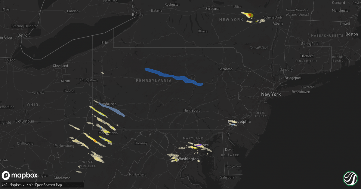
Hail Map in Pennsylvania on June 14, 2021
Get this storm
June 14 map
$229
one time, instant access
Download today. No call, no setup
Keep the $229
Bought the map and want the full workflow? Apply the entire $229 to a subscription within 7 days. None of it is wasted.
Every map, not just this one
This buys you this map. Subscription and you get every map we run, in the markets you choose from a few cities to whole states to nationwide. Plus real-time alerts the moment a storm fires.
Contact data
Name, contact info, occupancy, even credit band for addresses in the footprint. You go from where it hit to who to call.
Become the source they trust
Unlimited branding weather history reports on demand. You already have the documented answer ready for the property owner, and you are the one who showed up with it.
Property data and RoofTrace estimates
Pull up any address you have got, its value and the exact code rules for that jurisdiction, straight from One Click Code. Then RoofTrace estimates the squares, pitch, and roof value, priced the way you price.
Storm reports in Pennsylvania
Pennsylvania
| Date | Description |
|---|---|
| 06/14/20216:55 PM CDT | Downed tree on old kings highway. Time estimated from radar. |
| 06/14/20215:47 PM CDT | Downed trees and wires near apple lane. Time estimated from radar. |
| 06/14/20215:15 PM CDT | Multiple trees down. |
| 06/14/20215:00 PM CDT | Multiple trees down |
| 06/14/20214:48 PM CDT | Large number of trees reported downed in and around the town. |
| 06/14/20214:31 PM CDT | Numerous trees and power lines reported down in the town and surrounding area. |
| 06/14/20214:25 PM CDT | Numerous trees and wires down within the town and surrounding area. |
| 06/14/20214:20 PM CDT | A local report indicates 1.00 inch wind near CARMICHAELS |
| 06/14/20214:05 PM CDT | Report of wires down in the area of robinhood lakes. |
| 06/14/20213:56 PM CDT | Trees and wires down. Time estimated from radar. |
| 06/14/20213:35 PM CDT | Trees and wires down near craig road and miller road. Time estimated from radar. |
| 06/14/20213:24 PM CDT | Wires down on middletown rd. And beaver rd in hempfield twp. |
| 06/14/20213:23 PM CDT | Trees down college ave... Hawksworth rd. |
| 06/14/20213:22 PM CDT | A few reports of trees down on hunter highway |
| 06/14/20213:21 PM CDT | Trees down on wires. |
| 06/14/20213:10 PM CDT | Numerous trees and wires down within the town and surrounding area. |
| 06/14/20213:00 PM CDT | Tree down on power lines |
| 06/14/20213:00 PM CDT | Trees and wires down around mount pleasant township |
| 06/14/20213:00 PM CDT | Tree down on multi-residential bldg. |
| 06/14/20212:59 PM CDT | Tree took off roof of building at 1928 edgebrook ave. |
| 06/14/20212:58 PM CDT | Sporadic reports of trees down and trees on wires in north centre township in the vicinity of route 93. |
| 06/14/20212:57 PM CDT | Tree down struck residence at 2500 b street... Liberty boro. Damage unknown |
| 06/14/20212:56 PM CDT | Tree down through roof of residence. |
| 06/14/20212:55 PM CDT | Large tree down into residence. No significant structural damage. |
| 06/14/20212:50 PM CDT | Widespread reports of trees and power lines downed across mt. Pleasant twp and donegal twp. Mt. Pleasant fire dept calling for assistance from surrounding fire depts. |
| 06/14/20212:50 PM CDT | Trees down on interstate 79/interstate 70 junction |
| 06/14/20212:47 PM CDT | Tree down on roof of residence. |
| 06/14/20212:35 PM CDT | A local report indicates 1.00 inch wind near WASHINGTON |
| 06/14/20212:28 PM CDT | A local report indicates 60 MPH wind near 1 W WEST MIFFLIN |
| 06/14/20212:25 PM CDT | Several trees down at campground on route 18 |
| 06/14/20212:22 PM CDT | Tree down on multi-residential bldg. |
| 06/14/20212:21 PM CDT | Trees down on wires. |
| 06/14/20212:20 PM CDT | Bascom ave closed due to tree and wires on roadway. |
| 06/14/20212:15 PM CDT | Tree down on roof of residence. |
| 06/14/20212:15 PM CDT | Multiple trees down. |
| 06/14/20212:15 PM CDT | Tree down on vehicle blocking roadway. 228 e. Miller ave. |
| 06/14/20212:12 PM CDT | E. Wilcox st. Closed with wires on the road. |
| 06/14/20212:10 PM CDT | Tree down through roof of residence. |
| 06/14/20212:10 PM CDT | Large tree down into residence. No significant structural damage. |
| 06/14/20212:05 PM CDT | Tree took off roof of building at 1928 edgebrook ave. |
| 06/14/20212:00 PM CDT | Tree down struck residence at 2500 b street... Liberty boro. Damage unknown |
| 06/14/20211:54 PM CDT | Large tree branches down. |
| 06/14/20211:53 PM CDT | Sporadic trees down across nippenose valley. |
| 06/14/20211:50 PM CDT | Tree down with wires at 311 e. Garden rd. |
| 06/14/20211:48 PM CDT | Tree down on roof of a garage. |
| 06/14/20211:45 PM CDT | Trees and wires down on chesnut st. At ridge rd. |
| 06/14/20211:45 PM CDT | Multiple trees reported down around the area. |
| 06/14/20211:36 PM CDT | Tree down blocking both lanes of pine-loganton road in wayne towsnhip. |
| 06/14/20211:35 PM CDT | Several reports of trees down between lock haven and avis. |
| 06/14/20211:17 PM CDT | Multiple trees down in the vicinity of route 120 |
| 06/14/20211:00 PM CDT | Tree down blocking ridge road in noyes township. |
| 06/14/202112:28 PM CDT | Trees and wires down in the vicinity of driftwood. |
| 06/14/202111:50 AM CDT | Trees/wires down. |
| 06/14/20217:47 AM CDT | At 1247 PM EDT, severe thunderstorms were located along a line extending from near Elk River to near St. Marys to Brandy Camp to near Brockway, moving east at 40 mph. HAZARD...60 mph wind gusts. SOURCE...Radar indicated. IMPACT...Expect damage to roofs, siding, and trees. Locations impacted include... St. Marys, DuBois, Cameron, Penfield, Karthaus, Force, Benezette, Stevenson Dam, Brandy Camp, Hicks Run, Brockport, Parker Dam State Park, Lecontes Mills, S.B. Elliot State Park, Medix Run, Truman, Kersey, Weedville, Driftwood and Treasure Lake.For those driving on Interstate 80, this includes areas between theDubois and Clearfield exits, specifically from mile markers 97 to111. |
| 06/14/20217:45 AM CDT | At 1245 PM EDT, a severe thunderstorm was located 9 miles northwest of Kittanning, moving southeast at 30 mph. HAZARD...Wind gusts to 60 mph. SOURCE...Radar. IMPACT...Expect damage to trees and power lines, resulting in some power outages. Locations impacted include... Kittanning... West Kittanning... East Brady... West Hills... Applewold... Templeton... |
| 06/14/20217:37 AM CDT | At 1237 AM EDT, severe thunderstorms were located along a line extending from Loysville to Colonel Denning State Park to 7 miles east of Big Spring State Park, moving southeast at 20 mph. HAZARD...60 mph wind gusts. SOURCE...Radar indicated. IMPACT...Expect damage to roofs, siding, and trees. Severe thunderstorms will be near... Loysville around 1240 AM EDT. Bloserville around 1250 AM EDT. Newville, Plainfield and Shermansdale around 100 AM EDT. Carlisle, Mechanicsburg, Carlisle Springs, Schlusser, New Kingstown, Wertzville, Mount Holly Springs, Boiling Springs, Walnut Bottom and Hogestown around 110 AM EDT.Other locations impacted by these severe thunderstorms includeLandisburg and Penn State Dickinson School Of Law.This includes the following Interstates... The Pennsylvania Turnpike from mile markers 207 to 233. Interstate 81 from mile markers 31 to 61.This includes Route 11 from east of Shippensburg to west of CampHill. |
| 06/14/20216:17 AM CDT | At 1117 AM EDT, a severe thunderstorm was located 10 miles southeast of Greenville, or 13 miles northwest of Grove City, moving east at 30 mph. HAZARD...Wind gusts to 60 mph and quarter-size hail. SOURCE...Radar. IMPACT...Minor hail damage to vehicles is possible. Expect wind damage to trees and power lines, resulting in some power outages. Locations impacted include... Grove City... Stoneboro... Harrisville... Sandy Lake... Clintonville... Fredonia... Kennerdell... Jackson Center... Barkeyville... Cherry Valley... Maurice K Goddard State Park... This includes the following highways... Interstate 79 in Pennsylvania between mile markers 119 and 131. Interstate 80 in Pennsylvania between mile markers 21 and 40. |
| 06/14/20214:29 AM CDT | At 928 PM EDT, a severe thunderstorm was located over Paulsboro, or 7 miles west of Gloucester City, moving east at 25 mph. HAZARD...60 mph wind gusts and quarter size hail. SOURCE...Radar indicated. IMPACT...Minor damage to vehicles is possible. Wind damage to roofs, siding, trees, and power lines is possible. Locations impacted include... Philadelphia, Camden, Gloucester City, Cherry Hill, Evesham, Chester, Deptford, Voorhees, West Deptford, Glassboro, Lindenwold, Bellmawr, Yeadon, Woodbury, Pitman, Clayton, Berlin, Folcroft, Paulsboro and Magnolia.People at the Gloucester County Mega Site should seek safe shelterimmediately!This includes the following highways... New Jersey Turnpike between exits 2 and 3. Interstate 95 in Pennsylvania between mile markers 7 and 19. Interstate 76 in Pennsylvania between mile markers 348 and 351. Interstate 76 in New Jersey between mile markers 0 and 3. Interstate 295 in New Jersey between mile markers 11 and 35. Interstate 676 in New Jersey between mile markers 0 and 1. Atlantic City Expressway between mile markers 37 and 44. |
| 06/14/20214:11 AM CDT | At 911 PM EDT, severe thunderstorms were located along a line extending from near Imlaystown to Camden, moving east at 30 mph. HAZARD...70 mph wind gusts and quarter size hail. SOURCE...Radar indicated. IMPACT...Minor damage to vehicles is possible. Expect considerable tree damage. Wind damage is also likely to mobile homes, roofs, and outbuildings. Locations impacted include... Philadelphia, Toms River, Trenton, Camden, Long Branch, Gloucester City, Lakewood, Cherry Hill, Bensalem, Jackson, Howell, Evesham, Mount Laurel, Manalapan, Willingboro, Voorhees, Medford, Tinton Falls, Lindenwold and Lumberton.People at the Burlington County Mega Site should seek safe shelterimmediately!This includes the following highways... New Jersey Turnpike between exits 3 and 8A. Pennsylvania Turnpike between mile markers 355 and 359. Interstate 95 in Pennsylvania between mile markers 34 and 40. Interstate 76 in New Jersey between mile markers 0 and 3. Interstate 195 in New Jersey between mile markers 0 and 34. Interstate 295 in New Jersey between mile markers 22 and 64. Interstate 676 in New Jersey between mile markers 0 and 4. Garden State Parkway between mile markers 98 and 106. |
| 06/14/20213:34 AM CDT | At 833 PM EDT, a severe thunderstorm was located over Broomall, or 11 miles west of Philadelphia, moving east at 30 mph. HAZARD...70 mph wind gusts and quarter size hail. SOURCE...Radar indicated. IMPACT...Minor damage to vehicles is possible. Expect considerable tree damage. Wind damage is also likely to mobile homes, roofs, and outbuildings. Locations impacted include... Philadelphia, Camden, Gloucester City, Cherry Hill, Bensalem, Deptford, Voorhees, West Deptford, Lindenwold, Bellmawr, Yeadon, Woodbury, Riverside, Conshohocken, Berlin, Palmyra, Folcroft, Swarthmore, Paulsboro and Jenkintown.People at the Burlington County Mega Site should seek safe shelterimmediately!This includes the following highways... New Jersey Turnpike between exits 3 and 4. Pennsylvania Turnpike between mile markers 351 and 355. Interstate 95 in Pennsylvania between mile markers 7 and 38. Interstate 76 in Pennsylvania between mile markers 332 and 351. Interstate 76 in New Jersey between mile markers 0 and 3. Interstate 295 in New Jersey between mile markers 19 and 39. Interstate 676 in Pennsylvania between mile markers 0 and 1. Interstate 676 in New Jersey between mile markers 0 and 4. Interstate 476 in Pennsylvania between mile markers 1 and 16. Atlantic City Expressway near mile marker 44. |
| 06/14/20211:27 AM CDT | At 627 PM EDT, a severe thunderstorm was located over Cassville, or near Star City, moving southeast at 35 mph. HAZARD...Wind gusts to 60 mph. SOURCE...Radar. IMPACT...Expect damage to trees and power lines, resulting in some power outages. Locations impacted include... Morgantown... Westover... Star City... Granville... Cassville... Brookhaven... Rivesville... Masontown... Blacksville... Mount Morris... Booth... Everettville...This includes the following highways... Interstate 68 in West Virginia between mile markers 1 and 10. Interstate 79 in Pennsylvania between mile markers 0 and 5. Interstate 79 in West Virginia between mile markers 140 and 160. |
| 06/14/20211:02 AM CDT | At 601 PM EDT, a severe thunderstorm was located 9 miles southwest of Waynesburg, moving east southeast at 35 mph. HAZARD...Wind gusts to 60 mph. SOURCE...Radar. IMPACT...Expect damage to trees and power lines, resulting in some power outages. Locations impacted include... Morgantown... Star City... Granville... Cassville... Rogersville... Grant Town... Bobtown... Aleppo... Blacksville... Mount Morris... New Freeport... Spraggs...This includes the following highways... Interstate 79 in Pennsylvania between mile markers 0 and 11. Interstate 79 in West Virginia between mile markers 154 and 160. |
| 06/14/202112:45 AM CDT | At 545 PM EDT, a severe thunderstorm was located near Cameron, or near Moundsville, moving east at 30 mph. HAZARD...Wind gusts to 60 mph and quarter-size hail. SOURCE...Radar. IMPACT...Minor hail damage to vehicles is possible. Expect wind damage to trees and power lines, resulting in some power outages. Locations impacted include... Cameron... Aleppo... New Freeport... Rocklick... Lone Oak... Beelers Station... |
| 06/13/202111:50 PM CDT | At 450 PM EDT, a severe thunderstorm was located near Waymart, or near Carbondale, moving east at 30 mph. HAZARD...60 mph wind gusts and quarter size hail. SOURCE...Radar indicated. IMPACT...Hail damage to vehicles is expected. Expect wind damage to roofs, siding, and trees. Locations impacted include... Lackawaxen, Honesdale, South Canaan, Waymart, Hawley, Prompton, Bethany, Headley, Seelyville and Beach Lake. |
| 06/13/202111:47 PM CDT | At 447 PM EDT, a severe thunderstorm was located 8 miles northwest of Waynesburg, moving southeast at 25 mph. HAZARD...Quarter-size hail. SOURCE...Radar. IMPACT...Minor damage to vehicles is possible. Locations impacted include... Waynesburg... Jefferson Boro... Fairdale... Rogersville... Marianna... Carmichaels... Rices Landing... Clarksville... Amity... Nineveh...This includes Interstate 79 in Pennsylvania between mile markers 7and 26. |
| 06/13/202111:22 PM CDT | At 422 PM EDT, a severe thunderstorm was located near Osterhout, or near Tunkhannock, moving east at 25 mph. HAZARD...60 mph wind gusts and quarter size hail. SOURCE...Radar indicated. IMPACT...Hail damage to vehicles is expected. Expect wind damage to roofs, siding, and trees. Locations impacted include... Scranton, Falls, Carbondale, Archbald, Blakely, Dickson City, Olyphant, Clarks Summit, Jessup and Throop. |
| 06/13/202111:15 PM CDT | At 413 PM EDT, severe thunderstorms were located along a line extending from near East Berwick to Rock Glen to Locustdale, moving east at 40 mph. HAZARD...60 mph wind gusts and penny size hail. SOURCE...Radar indicated. IMPACT...Damage to roofs, siding, trees, and power lines is possible. Locations impacted include... Lehighton, Palmerton, Kutztown, Jim Thorpe, Hamburg, Slatington, Fleetwood, Nesquehoning, Weatherly, Walnutport, Lenhartsville, New Mahoning, Neffs, Lake Harmony, New Tripoli, Berlinsville, Albrightsville, Emerald, Kresgeville and Sun Valley.This includes the following highways... Northeast Extension between mile markers 63 and 97. Interstate 78 in Pennsylvania between mile markers 29 and 47. Interstate 80 in Pennsylvania between mile markers 277 and 289. |
| 06/13/202111:11 PM CDT | At 410 PM EDT, severe thunderstorms were located along a line extending from near Muhlenberg to near Aristes, moving east at 50 mph. HAZARD...60 mph wind gusts. SOURCE...Radar indicated. IMPACT...Expect damage to roofs, siding, and trees. Locations impacted include... Hazleton, Berwick, West Hazleton, Freeland, Dorrance, Conyngham, Nescopeck, Slocum, White Haven and Shickshinny. |
| 06/13/202111:10 PM CDT | At 410 PM EDT, severe thunderstorms were located along a line extending from near Rock Glen to near Brandonville to Lavelle, moving east at 40 mph. HAZARD...60 mph wind gusts. SOURCE...Radar indicated. IMPACT...Expect damage to roofs, siding, and trees. Locations impacted include... Tamaqua, Shenandoah, Mahanoy City, Frackville, Ashland, Mcadoo, Girardville, Hometown, Tuscarora, New Philadelphia, Oneida, Grier City-Park Crest, Lavelle, Altamont, Englewood, Delano, Nuremburg, Aristes, Fountain Springs and Sheppton.For those driving on Interstate 80, this includes areas between theMifflinville and Nescopek exits, specifically from mile markers 246to 247.This includes Interstate 81 from mile markers 120 to 139. |
| 06/13/202111:04 PM CDT | At 403 PM EDT, a severe thunderstorm was located over Northern Cambria, moving east at 40 mph. HAZARD...60 mph wind gusts and penny size hail. SOURCE...Radar indicated. IMPACT...Expect damage to roofs, siding, and trees. Locations impacted include... Ebensburg, Nanty-Glo, Northern Cambria, Patton, Cresson, Gallitzin, Loretto, Hastings, Carrolltown, Sankertown, Belsano, Horseshoe Curve, Prince Gallitzin State Park, Colver, Tunnelhill, Ashville, Chest Springs, Allegheny Portage Railroad National Historic Site, Penn State Altoona and Saint Francis University. |
| 06/13/202110:55 PM CDT | At 354 PM EDT, a severe thunderstorm was located over Mount Pleasant, or 8 miles south of Greensburg, moving southeast at 35 mph. HAZARD...Wind gusts to 60 mph. SOURCE...Radar. IMPACT...Expect damage to trees and power lines, resulting in some power outages. Locations impacted include... Greensburg... Jeannette... Mount Pleasant... Scottdale... Youngwood... Lawson Heights... New Stanton... Ligonier... Seven Springs... Calumet-Norvelt... Madison... Arona...This includes the following highways... Interstate 70 in Pennsylvania between mile markers 52 and 57. Pennsylvania Turnpike between mile markers 70 and 99. |
| 06/13/202110:52 PM CDT | At 352 PM EDT, a severe thunderstorm was located over Bentleyville, or 11 miles southeast of Washington, moving southeast at 20 mph. HAZARD...Wind gusts to 60 mph and quarter-size hail. SOURCE...Radar. IMPACT...Minor hail damage to vehicles is possible. Expect wind damage to trees and power lines, resulting in some power outages. Locations impacted include... California... Charleroi... Bentleyville... Brownsville... Fredericktown-Millsboro... Perryopolis... Fairdale... Speers... Isabella... Belle Vernon... Ellsworth... Lynnwood-Pricedale...This includes Interstate 70 in Pennsylvania between mile markers 29and 40. |
| 06/13/202110:42 PM CDT | At 342 PM EDT, a severe thunderstorm was located 8 miles northeast of Indiana, moving east at 55 mph. HAZARD...Wind gusts to 60 mph and quarter-size hail. SOURCE...Radar. IMPACT...Minor hail damage to vehicles is possible. Expect wind damage to trees and power lines, resulting in some power outages. Locations impacted include... Indiana... Clymer... Chevy Chase Heights... Ernest... Marion Center... Cherry Tree... Creekside... Plumville... Glen Campbell... Dixonville... Commodore... Rochester Mills... |
| 06/13/202110:29 PM CDT | At 329 PM EDT, a severe thunderstorm was located over White Oak, or near McKeesport, moving east at 35 mph. HAZARD...Wind gusts to 60 mph. SOURCE...Radar. IMPACT...Expect damage to trees and power lines, resulting in some power outages. Locations impacted include... Greensburg... McKeesport... Jeannette... West Mifflin... South Park Township... Jefferson Hills... North Versailles... White Oak... Clairton... Duquesne... Glassport... Irwin...This includes the following highways... Interstate 70 in Pennsylvania between mile markers 47 and 57. Pennsylvania Turnpike between mile markers 64 and 81. |
| 06/13/202110:26 PM CDT | At 326 PM EDT, a severe thunderstorm was located over Wolfdale, or near Washington, moving east at 45 mph. HAZARD...Wind gusts to 60 mph and quarter-size hail. SOURCE...Radar. IMPACT...Minor hail damage to vehicles is possible. Expect wind damage to trees and power lines, resulting in some power outages. Locations impacted include... Washington... Canonsburg... Wolfdale... McGovern... Bentleyville... East Washington... North Charleroi... Houston... Ellsworth... Eighty Four... Cokeburg... Hickory...This includes the following highways... Interstate 70 in Pennsylvania between mile markers 12 and 35. Interstate 79 in Pennsylvania between mile markers 24 and 45. |
| 06/13/202110:18 PM CDT | At 316 PM EDT, severe thunderstorms were located along a line extending from Montgomery to New Columbia to Mifflinburg, moving east at 35 mph. HAZARD...60 mph wind gusts. SOURCE...Radar indicated. IMPACT...Expect damage to roofs, siding, and trees. Locations impacted include... Bloomsburg, Berwick, Sunbury, Milton, Lewisburg, Danville, Montoursville, Northumberland, Mifflinburg, Winfield, Muncy, Watsontown, Elysburg, Riverside, Montgomery, Catawissa, Linntown, Mifflinville, Lightstreet and Almedia.For those driving on Interstate 80, this includes areas between theMile Run and Nescopek exits, specifically from mile markers 202 to247.This includes Interstate 180 from mile markers 1 to 14. |
| 06/13/202110:05 PM CDT | At 305 PM EDT, a severe thunderstorm was located over Scott Township, or over Mount Lebanon, moving east at 40 mph. HAZARD...Wind gusts to 60 mph. SOURCE...Radar. IMPACT...Expect damage to trees and power lines, resulting in some power outages. Locations impacted include... Pittsburgh... Mount Lebanon... Bethel Park... McMurray... McKeesport... Jeannette... Gastonville... West Mifflin... North Side Pittsburgh... Baldwin... Upper St. Clair... Scott Township...This includes the following highways... Pennsylvania Turnpike between mile markers 64 and 68. Interstate 79 in Pennsylvania between mile markers 51 and 62. Interstate 376 in Pennsylvania between mile markers 62 and 75. |
| 06/13/202110:01 PM CDT | At 301 PM EDT, a severe thunderstorm was located near Hooverson Heights, or near Weirton, moving east at 40 mph. HAZARD...Quarter-size hail. SOURCE...Radar. IMPACT...Minor damage to vehicles is possible. Locations impacted include... Weirton... Steubenville... Canonsburg... Wellsburg... Avella... Cecil-Bishop... Wintersville... Mingo Junction... Follansbee... Wolfdale... McGovern... Hooverson Heights...This includes Interstate 79 in Pennsylvania between mile markers 47and 49. |
| 06/13/20219:33 PM CDT | At 233 PM EDT, a severe thunderstorm was located near Imperial, or near Moon Township, moving southeast at 40 mph. HAZARD...Wind gusts to 60 mph. SOURCE...Radar. IMPACT...Expect damage to trees and power lines, resulting in some power outages. Locations impacted include... Pittsburgh... Mount Lebanon... Bethel Park... Moon Township... Upper St. Clair... Scott Township... Whitehall... Robinson Township... Cecil-Bishop... Dormont... Bellevue... Castle Shannon...This includes the following highways... Interstate 79 in Pennsylvania between mile markers 50 and 66. Interstate 376 in Pennsylvania between mile markers 48 and 68. |
| 06/13/20219:33 PM CDT | At 233 PM EDT, severe thunderstorms were located along a line extending from near Cammal to near McElhattan to Mackeyville, moving east at 35 mph. HAZARD...60 mph wind gusts. SOURCE...Radar indicated. IMPACT...Expect damage to roofs, siding, and trees. Locations impacted include... Williamsport, Lock Haven, Lewisburg, Montoursville, Jersey Shore, Carroll, Muncy, Mill Hall, Montgomery, Linntown, Avis, Dunnstown, Flemington, Duboistown, Castanea, New Columbia, McElhattan, Allenwood, Elimsport and Waterville.For those driving on Interstate 80, this includes areas between theLamar and Milton-Williamsport exits, specifically from mile markers177 to 210.This includes Interstate 180 near mile marker 10...and from milemarkers 15 to 29. |
| 06/13/20218:31 PM CDT | At 130 PM EDT, severe thunderstorms were located along a line extending from near Wharton to near Stevenson Dam to 8 miles north of Karthaus, moving east at 40 mph. HAZARD...60 mph wind gusts. SOURCE...Radar indicated. IMPACT...Expect damage to roofs, siding, and trees. Locations impacted include... Lock Haven, Keating, Avis, Dunnstown, Flemington, Renovo, Castanea, McElhattan, South Renovo, Westport, Glen Union, Hyner, Tamarack, Kettle Creek State Park and Lock Haven University. |
| 06/13/20218:12 PM CDT | At 111 AM EDT, a severe thunderstorm was located over Carlisle, moving southeast at 25 mph. HAZARD...60 mph wind gusts. SOURCE...Radar indicated. IMPACT...Expect damage to roofs, siding, and trees. Locations impacted include... Carlisle, Lower Allen, Mechanicsburg, Camp Hill, New Cumberland, Plainfield, Schlusser, Valley Green, Boiling Springs, Dillsburg, Mount Holly Springs, Shiremanstown, New Kingstown, Siddonsburg, Hogestown, Wertzville, Carlisle Springs, Goldsboro, Franklintown and Lewisberry.This includes the following Interstates... The Pennsylvania Turnpike from mile markers 219 to 245. Interstate 81 from mile markers 42 to 59. Interstate 83 from mile markers 29 to 40. |
| 06/13/20218:06 PM CDT | Downed trees and wires near smithbridge road. Time estimated from radar. |
| 06/13/20218:05 PM CDT | Report of a few trees down in the area of bridgewater road. Time estimated from radar. |
| 06/13/20218:02 PM CDT | An mping report of large tree limbs or power lines down. Time estimated from radar. |
| 06/13/20218:00 PM CDT | Wires down due to strong winds. Time estimated from radar. |
| 06/13/20217:55 PM CDT | Downed tree on byberry road. Time estimated from radar. |
| 06/13/20217:40 PM CDT | A local report indicates 1.00 inch wind near CLIFTON HEIGHTS |
| 06/13/20217:39 PM CDT | Downed tree limbs blocking haverford road near remington road. Time estimated from radar. |
| 06/13/20217:25 PM CDT | Trees and wires down on montgomery ave... Time estimated from radar. |
| 06/13/20217:25 PM CDT | Trees down causing a power outage. Time estimated from radar. |
| 06/13/20217:16 PM CDT | Downed tree limbs near depot street. Time estimated from radar. |
| 06/13/20217:12 PM CDT | Trees and wires down near route 202 in malvern... Time estimated from radar. |
| 06/13/20217:00 PM CDT | Downed tree on sugarsbridge road near alton pa. Time estimated from radar. |
All States Impacted by Hail Map on June 14, 2021
Cities Impacted by Hail Map on June 14, 2021
- Hamlin, TX
- McCaulley, TX
- Roscoe, TX
- Sylvester, TX
- Sweetwater, TX
- Rotan, TX
- Roby, TX
- Aladdin, WY
- Verbena, AL
- Prattville, AL
- Marbury, AL
- Raleigh, MS
- Moccasin, MT
- Montgomery, AL
- Crowley, TX
- Fort Worth, TX
- Dundalk, MD
- Curtis Bay, MD
- Sparrows Point, MD
- Catonsville, MD
- Baltimore, MD
- Brooklyn, MD
- Gwynn Oak, MD
- Halethorpe, MD
- Sheffield, TX
- Iraan, TX
- Fort Deposit, AL
- Franklin, GA
- Evant, TX
- Star, TX
- Goldthwaite, TX
- Port Lavaca, TX
- Custer, SD
- Wallis, TX
- Sealy, TX
- Roy, MT
- Saint Matthews, SC
- Swansea, SC
- Sonora, TX
- Waynesburg, PA
- Graysville, PA
- Claysville, PA
- West Finley, PA
- Prosperity, PA
- Nineveh, PA
- Sycamore, PA
- Amity, PA
- Mather, PA
- McClellandtown, PA
- Nemacolin, PA
- Ronco, PA
- Carmichaels, PA
- Greensboro, PA
- Clarksville, PA
- Jefferson, PA
- Masontown, PA
- Delanson, NY
- Esperance, NY
- Schoharie, NY
- Lewisville, OH
- Woodsfield, OH
- Horner, WV
- Rock Cave, WV
- Buckhannon, WV
- Adrian, WV
- Walkersville, WV
- Crawford, WV
- French Creek, WV
- Weston, WV
- San Saba, TX
- Lometa, TX
- Lancaster, SC
- Winnsboro, SC
- Great Falls, SC
- Blackstock, SC
- Richburg, SC
- Fort Lawn, SC
- Oral, SD
- Lowndesboro, AL
- Madison, NC
- Walnut Cove, NC
- Victoria, TX
- Bombay, NY
- Moira, NY
- Spraggs, PA
- Mount Morris, PA
- Union Grove, NC
- Harmony, NC
- Juliette, GA
- Forsyth, GA
- Miles, TX
- San Angelo, TX
- Chantilly, VA
- Aldie, VA
- Weston, OR
- Dayton, WA
- Pomeroy, WA
- Waitsburg, WA
- Walla Walla, WA
- Milton Freewater, OR
- Colliers, WV
- Follansbee, WV
- Columbia, MD
- Ellicott City, MD
- Newcastle, WY
- Christoval, TX
- Vancourt, TX
- Weimar, TX
- Hallettsville, TX
- Godley, TX
- Columbia, AL
- Abbeville, AL
- Avella, PA
- Washington, PA
- Lothian, MD
- Harwood, MD
- Saint John, WA
- Endicott, WA
- Brasher Falls, NY
- Roanoke, AL
- Wedowee, AL
- Woodland, AL
- Fort Stockton, TX
- Folsom, WV
- Lumberport, WV
- Jacksonburg, WV
- Wallace, WV
- Smithfield, WV
- Hamilton, TX
- Hico, TX
- Holbrook, PA
- Clarksburg, WV
- Reader, WV
- Pine Grove, WV
- Rushville, NE
- Hay Springs, NE
- Winnett, MT
- Sand Springs, MT
- Roundup, MT
- Mosby, MT
- Ingomar, MT
- Pelzer, SC
- Williamston, SC
- Meridian, TX
- Morgan, TX
- Pine Ridge, SD
- Oelrichs, SD
- Rapid City, SD
- Gainesville, VA
- Catharpin, VA
- Manassas, VA
- Centreville, VA
- Haymarket, VA
- Westford, NY
- Worcester, NY
- Cherry Valley, NY
- Schenevus, NY
- Richfield Springs, NY
- Springfield Center, NY
- Jordanville, NY
- Van Hornesville, NY
- Colton, WA
- Steubenville, OH
- Weirton, WV
- Burgettstown, PA
- Hot Springs, SD
- Cokeburg, PA
- Eighty Four, PA
- Scenery Hill, PA
- Medina, TX
- West Union, WV
- Pennsboro, WV
- Hill City, SD
- Dawsonville, GA
- Smithwick, SD
- Richland Springs, TX
- Headland, AL
- Joshua, TX
- Junction City, GA
- Butler, GA
- Mullin, TX
- Rochelle, TX
- Brookeville, MD
- Glenwood, MD
- Woodbine, MD
- Crawfordville, GA
- Union Point, GA
- Ozona, TX
- Dryden, TX
- Blacksburg, SC
- Kings Mountain, NC
- Cleburne, TX
- Farmington, WV
- Fairmont, WV
- Grafton, WV
- Independence, WV
- Tallmansville, WV
- Preston, GA
- Chadron, NE
- Comstock, TX
- Mohawk, NY
- Maryneal, TX
- Saint Marys, WV
- Newport, OH
- Iredell, TX
- Magee, MS
- Mendenhall, MS
- Baldwin, GA
- Cornelia, GA
- Mount Airy, GA
- Rockwood, TX
- Buffalo Gap, SD
- Barksdale, TX
- Ashburn, VA
- Hookstown, PA
- Clinton, PA
- Rio Vista, TX
- Alvarado, TX
- Grandview, TX
- Covington, TX
- Brandon, MS
- Pelahatchie, MS
- Dale, TX
- Lockhart, TX
- Red Rock, TX
- Morgantown, WV
- Maidsville, WV
- Osage, WV
- Granville, WV
- Pursglove, WV
- Montgomery Village, MD
- Boyds, MD
- Germantown, MD
- Gaithersburg, MD
- Dickerson, MD
- Camden, WV
- Bryan, TX
- Duck, WV
- Rosedale, WV
- Chloe, WV
- Thomaston, AL
- Catherine, AL
- Ernul, NC
- Media, PA
- Glenolden, PA
- Folcroft, PA
- West Chester, PA
- Glen Mills, PA
- Springfield, PA
- Holmes, PA
- Morton, PA
- Drexel Hill, PA
- Malvern, PA
- Clifton Heights, PA
- Broomall, PA
- Lansdowne, PA
- Sharon Hill, PA
- Havertown, PA
- Newtown Square, PA
- Philadelphia, PA
- Darby, PA
- Central, SC
- Loganville, GA
- Conyers, GA
- Oxford, GA
- Elgin, OR
- Autaugaville, AL
- Rock Hall, MD
- Decatur, GA
- Sterling, VA
- Lead, SD
- Sturgis, SD
- Whitewood, SD
- Deadwood, SD
- Spearfish, SD
- Social Circle, GA
- Mansfield, GA
- Bethany, WV
- Valley Grove, WV
- West Alexander, PA
- Laurel, MD
- Bowie, MD
- Selma, AL
- Covington, GA
- Elkridge, MD
- Wind Ridge, PA
- Vineland, NJ
- Bandera, TX
- Homer, GA
- Odenville, AL
- Woodstock, MD
- Marriottsville, MD
- Garwood, TX
- Cameron, WV
- Dallas, WV
- Moundsville, WV
- Lagrange, GA
- Cooperstown, NY
- East Springfield, NY
- Kingston, ID
- Roseboom, NY
- Jane Lew, WV
- Shorter, AL
- Marietta, OH
- New Matamoras, OH
- Reno, OH
- Whipple, OH
- Morton, MS
- Center Point, TX
- Cranfills Gap, TX
- Bruceton Mills, WV
- Farmington, PA
- Gibbon Glade, PA
- Lake Lynn, PA
- Smithfield, PA
- Easley, SC
- Liberty, SC
- Leakey, TX
- Rio Frio, TX
- Stoneboro, PA
- Mercer, PA
- Jackson Center, PA
- Kellogg, ID
- Ellsworth, NE
- Tallassee, AL
- Eclectic, AL
- Sylacauga, AL
- Friendly, WV
- Mocksville, NC
- Clarksville, MD
- Glen Easton, WV
- Millersville, MD
- Odenton, MD
- Gambrills, MD
- Meadville, MS
- Kerrville, TX
- Gilbertown, AL
- Colfax, WA
- Thornton, WA
- Middlebourne, WV
- New Milton, WV
- Dayton, MD
- Commerce, GA
- Carnesville, GA
- Brushton, NY
- Severn, MD
- Del Rio, TX
- Wadley, AL
- Daviston, AL
- Ellenboro, WV
- Bastrop, TX
- Arlington, TX
- Bingham, NE
- Jonesboro, TX
- Uniontown, AL
- Faunsdale, AL
- Sunset, SC
- Graham, AL
- Bowdon, GA
- Roopville, GA
- Billingsley, AL
- Conover, NC
- Stedman, NC
- Wade, NC
- Goliad, TX
- Adger, AL
- Gainesville, GA
- Howes Cave, NY
- Marianna, PA
- Gouldbusk, TX
- Littleton, WV
- Jacksons Gap, AL
- Bluffton, GA
- Cuba, AL
- Ilion, NY
- Fort Plain, NY
- West Winfield, NY
- Crum Lynne, PA
- Woodlyn, PA
- Chester, PA
- Brookhaven, PA
- Gibbstown, NJ
- Barrackville, WV
- Minter, AL
- Ohiopyle, PA
- Chalk Hill, PA
- Comfort, TX
- Imperial, PA
- Forest City, NC
- Mooresboro, NC
- Rutherfordton, NC
- Gillette, WY
- Hayneville, AL
- Cayce, SC
- West Columbia, SC
- Columbia, SC
- Hopkins, SC
- Gaston, SC
- Richland, NJ
- Buena, NJ
- Sutton, WV
- Central Bridge, NY
- Rock Hill, SC
- Hanover, MD
- Lincolnton, GA
- Cobleskill, NY
- Robert Lee, TX
- Clarkesville, GA
- Long Creek, SC
- McCall Creek, MS
- Saint Regis Falls, NY
- Trent, TX
- Lohn, TX
- Glen Burnie, MD
- Pasadena, MD
- Chestertown, MD
- Fort Howard, MD
- Musella, GA
- Macon, GA
- Wallowa, OR
- Stevensville, MD
- Blacksville, WV
- Fairview, WV
- Rogersville, PA
- Dilliner, PA
- Edgemoor, SC
- Catawba, SC
- Aliquippa, PA
- Cooksville, MD
- Sykesville, MD
- Newton, NC
- Claremont, NC
- Brevard, NC
- Rosman, NC
- Gillsville, GA
- Trenton, SC
- Aiken, SC
- Toxey, AL
- Elk, WA
- Newborn, GA
- Blum, TX
- Newhebron, MS
- Sikes, LA
- Osage, WY
- Temple, TX
- New Martinsville, WV
- Shinnston, WV
- Bridgeport, WV
- Meadowbrook, WV
- Porters Falls, WV
- Spelter, WV
- Flemington, WV
- Hepzibah, WV
- Philippi, WV
- Yadkinville, NC
- Booth, AL
- Wesson, MS
- Newville, AL
- Shorterville, AL
- Clarkston, WA
- Granbury, TX
- Salem, SC
- Tamassee, SC
- Walhalla, SC
- Clanton, AL
- Windsor Mill, MD
- Six Mile, SC
- Richmondville, NY
- Lamont, WA
- Hampton, GA
- Locust Grove, GA
- Glenelg, MD
- Eagle Lake, TX
- Cheney, WA
- Tunnelton, WV
- Newburg, WV
- Thornton, WV
- Goodwater, AL
- Toccoa, GA
- Palacios, TX
- Helvetia, WV
- Purcellville, VA
- Leesburg, VA
- Herndon, VA
- Clifton, VA
- Middleburg, VA
- Fairfax, VA
- Doole, TX
- Nordman, ID
- Grass Range, MT
- Atlanta, GA
- Fairburn, GA
- Ward, AL
- Summerfield, OH
- Senecaville, OH
- Columbus, TX
- Robstown, TX
- Chattaroy, WA
- Bronte, TX
- Fulshear, TX
- Coal Center, PA
- Bentleyville, PA
- Daisytown, PA
- Ellsworth, PA
- Hickory, PA
- Crystal Springs, MS
- Harrisville, MS
- Florence, MS
- Sloansville, NY
- Davenport, WA
- Newport, WA
- Thornton, PA
- Swedesboro, NJ
- Essington, PA
- Chester Heights, PA
- Wallingford, PA
- Ridley Park, PA
- Garnet Valley, PA
- Aston, PA
- Alum Bridge, WV
- Ivydale, WV
- Clay, WV
- Wallback, WV
- Hulett, WY
- Arvada, WY
- Recluse, WY
- Ormond Beach, FL
- Bunnell, FL
- Palm Coast, FL
- Flagler Beach, FL
- Linthicum Heights, MD
- Austwell, TX
- Tivoli, TX
- Seadrift, TX
- Canajoharie, NY
- Saint Marys, PA
- Northumberland, PA
- Driftwood, PA
- Allenwood, PA
- Bloomsburg, PA
- Kersey, PA
- New Columbia, PA
- Weedville, PA
- Mifflinburg, PA
- Williamsport, PA
- Riverside, PA
- Jersey Shore, PA
- Mill Hall, PA
- Benezett, PA
- Beech Creek, PA
- Loganton, PA
- Lock Haven, PA
- White Deer, PA
- Pottersdale, PA
- Watsontown, PA
- McEwensville, PA
- Danville, PA
- Sinnamahoning, PA
- Linden, PA
- Karthaus, PA
- Westport, PA
- Lewisburg, PA
- Renovo, PA
- Milton, PA
- Avis, PA
- Mount Pleasant, PA
- Buena Vista, PA
- Madison, PA
- Glassport, PA
- McDonald, PA
- Acme, PA
- Jones Mills, PA
- Coraopolis, PA
- Adamsburg, PA
- Elizabeth, PA
- Dravosburg, PA
- Stahlstown, PA
- Carnegie, PA
- West Newton, PA
- Yukon, PA
- West Mifflin, PA
- Arona, PA
- Irwin, PA
- Greenock, PA
- New Stanton, PA
- Bridgeville, PA
- Youngwood, PA
- Champion, PA
- Tarrs, PA
- Donegal, PA
- Bethel Park, PA
- Darragh, PA
- Oakdale, PA
- Rillton, PA
- Jeannette, PA
- Pittsburgh, PA
- Clairton, PA
- Presto, PA
- Herminie, PA
- Ruffs Dale, PA
- Hunker, PA
- Mckeesport, PA
- Greensburg, PA
- Swarthmore, PA
- Marcus Hook, PA
- Folsom, PA


