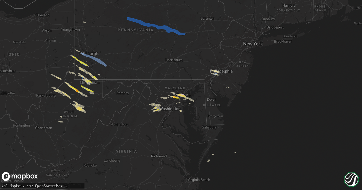
Hail Map on June 14, 2021
Get this storm
June 14 map
$229
one time, instant access
Download today. No call, no setup
Keep the $229
Bought the map and want the full workflow? Apply the entire $229 to a subscription within 7 days. None of it is wasted.
Every map, not just this one
This buys you this map. Subscription and you get every map we run, in the markets you choose from a few cities to whole states to nationwide. Plus real-time alerts the moment a storm fires.
Contact data
Name, contact info, occupancy, even credit band for addresses in the footprint. You go from where it hit to who to call.
Become the source they trust
Unlimited branding weather history reports on demand. You already have the documented answer ready for the property owner, and you are the one who showed up with it.
Property data and RoofTrace estimates
Pull up any address you have got, its value and the exact code rules for that jurisdiction, straight from One Click Code. Then RoofTrace estimates the squares, pitch, and roof value, priced the way you price.
States Impacted by Hail Map on June 14, 2021
Storm reports
Georgia
| Date | Description |
|---|---|
| 06/14/20214:15 PM CDT | The walton county emergency manager reported trees down around alcova drive and county line road in social circle. |
| 06/14/20214:15 PM CDT | The walton county emergency manager reported power lines down on vine circle in social circle. |
| 06/14/20214:10 PM CDT | The walton county emergency manager reported trees and power lines down along s. Broad street in monroe. One tree was down on a mobile home. |
| 06/14/20214:07 PM CDT | Golf ball sized hail was reported along center hill church rd. |
| 06/14/20214:07 PM CDT | Cedar lakes golf club reported hail from dime to quarter sized. |
| 06/14/20214:00 PM CDT | The walton county emergency manager reported trees down around s. Sharon church road and white road in loganville. |
| 06/14/20213:55 PM CDT | The walton county emergency manager reported power lines down on highway 81 in loganville. |
| 06/14/20213:55 PM CDT | The walton county emergency manager reported trees and power lines down along claude brewer road in loganville. |
| 06/14/20213:54 PM CDT | Approximatly five trees were reported down near the intersection england capel rd and county line rd. One tree was reported on a powerline. |
| 06/14/20213:33 PM CDT | A group of trees were reported down at 677 cemetery rd. Time estimated based on radar. |
| 06/14/20213:31 PM CDT | Multiple reports of trees downed in the community of preston. |
| 06/14/20213:15 PM CDT | Emergency management reporting structural damage to a warehouse on cobb st in jefferson. A awning made of sheet metal was torn off the side of the building and dmage to |
| 06/14/20212:52 PM CDT | A tree was reported down on a car on mitchell ave. |
| 06/14/20211:50 PM CDT | Multiple trees reported down along dean couch rd. |
| 06/14/20211:46 PM CDT | A tree was reported down on a home and powerline on w mountainside drive. |
| 06/14/20212:01 AM CDT | At 701 PM EDT, a severe thunderstorm was located over Lyneville, or near Crawfordville, moving southeast at 20 mph. HAZARD...60 mph wind gusts and quarter size hail. SOURCE...Radar indicated. IMPACT...Hail damage to vehicles is expected. Expect wind damage to roofs, siding, and trees. Locations impacted include... Crawfordville, Sharon, Ficklin, Barnett, Robinson, Lyneville, Raytown, Alexander Stephens Park, Sandy Cross, Carters Grove and Daniel Springs. |
| 06/14/20211:40 AM CDT | At 640 PM EDT, a severe thunderstorm was located near Lake Tobesofkee, or 11 miles south of Forsyth, moving south at 15 mph. HAZARD...60 mph wind gusts and quarter size hail. SOURCE...Radar indicated. IMPACT...Hail damage to vehicles is expected. Expect wind damage to roofs, siding, and trees. Locations impacted include... Macon, Roberta, Knoxville, Lizella, Lake Tobesofkee, Bolingbroke, Jack Brown Estates, Lee Pope, Sandy Point, Horns, Russellville and Musella. |
| 06/13/202111:52 PM CDT | At 452 PM EDT, a severe thunderstorm was located over Youth, or 10 miles west of Monroe, moving south at 15 mph. HAZARD...60 mph wind gusts and half dollar size hail. SOURCE...Radar indicated. IMPACT...Hail damage to vehicles is expected. Expect wind damage to roofs, siding, and trees. Locations impacted include... Conyers, Covington, Snellville, Loganville, Social Circle, Oxford, Porterdale, Walnut Grove, Newborn, Between, Jersey, Lakeview Estates, Georgia International Horse Park, Almon, Milstead, Youth, Starrsville, Big Haynes Creek Park, Brick Store and Rosebud. |
| 06/13/202111:15 PM CDT | At 414 PM EDT, a severe thunderstorm was located near Luella, or 7 miles southwest of McDonough, moving southeast at 15 mph. HAZARD...60 mph wind gusts and quarter size hail. SOURCE...Radar indicated. IMPACT...Hail damage to vehicles is expected. Expect wind damage to roofs, siding, and trees. Locations impacted include... Griffin, McDonough, Hampton, Locust Grove, Orchard Hill, Sunny Side, East Griffin, Highland Mills, Blacksville, Towalaga, Experiment, Walker Mill, McKibben, Luella and Atlanta Motor Speedway. |
| 06/13/202110:41 PM CDT | At 341 PM EDT, a severe thunderstorm was located 5 miles west of Carnesville, moving south at 10 mph. HAZARD...60 mph wind gusts and quarter size hail. SOURCE...Radar indicated. IMPACT...Minor hail damage to vehicles is expected. Expect wind damage to trees and power lines. Locations impacted include... Carnesville and Victoria Bryant State Park. |
| 06/13/202110:23 PM CDT | At 323 PM EDT, a severe thunderstorm was located near Hillcrest, or near Franklin, moving southeast at 25 mph. HAZARD...60 mph wind gusts and quarter size hail. SOURCE...Radar indicated. IMPACT...Hail damage to vehicles is expected. Expect wind damage to roofs, siding, and trees. Locations impacted include... LaGrange, Greenville, West Point, Hogansville, Warm Springs, Lone Oak, Corinth, Mountville, Cannonville, Louise, Odessadale, Stovall, Piedmont Heights, Harrisonville, Hillcrest, Big Springs, Wares Crossroads, Glenn, Saint Marks and Raleigh. |
Mississippi
| Date | Description |
|---|---|
| 06/14/20215:44 PM CDT | Couple trees downed along ms 28 west of magee. |
| 06/14/20211:12 AM CDT | At 612 PM CDT, a severe thunderstorm was located over Gwinville, or 12 miles south of Pinola, moving south at 10 mph. HAZARD...60 mph wind gusts. SOURCE...Radar indicated. IMPACT...Expect damage to roofs, siding, and trees. Locations impacted include... Monticello, Prentiss, Clem, Progress, Carson, New Hebron and Silver Creek. |
| 06/14/20211:09 AM CDT | At 609 PM CDT, a severe thunderstorm was located over Hopewell, or near Crystal Springs, moving south at 10 mph. HAZARD...60 mph wind gusts and penny size hail. SOURCE...Radar indicated. IMPACT...Expect damage to roofs, siding, and trees. This severe thunderstorm will be near... Crystal Springs and Hopewell around 625 PM CDT. |
| 06/14/202112:04 AM CDT | At 504 PM CDT, a severe thunderstorm was located near Raleigh, or 13 miles northeast of Magee, moving southwest at 15 mph. HAZARD...60 mph wind gusts and quarter size hail. SOURCE...Radar indicated. IMPACT...Hail damage to vehicles is expected. Expect wind damage to roofs, siding, and trees. Locations impacted include... Magee, Mendenhall, Raleigh, Sanatorium, Martinville, White Oak and Mize. |
Pennsylvania
| Date | Description |
|---|---|
| 06/14/20216:55 PM CDT | Downed tree on old kings highway. Time estimated from radar. |
| 06/14/20215:47 PM CDT | Downed trees and wires near apple lane. Time estimated from radar. |
| 06/14/20215:15 PM CDT | Multiple trees down. |
| 06/14/20215:00 PM CDT | Multiple trees down |
| 06/14/20214:48 PM CDT | Large number of trees reported downed in and around the town. |
| 06/14/20214:31 PM CDT | Numerous trees and power lines reported down in the town and surrounding area. |
| 06/14/20214:25 PM CDT | Numerous trees and wires down within the town and surrounding area. |
| 06/14/20214:20 PM CDT | A local report indicates 1.00 inch wind near CARMICHAELS |
| 06/14/20214:05 PM CDT | Report of wires down in the area of robinhood lakes. |
| 06/14/20213:56 PM CDT | Trees and wires down. Time estimated from radar. |
| 06/14/20213:35 PM CDT | Trees and wires down near craig road and miller road. Time estimated from radar. |
| 06/14/20213:24 PM CDT | Wires down on middletown rd. And beaver rd in hempfield twp. |
| 06/14/20213:23 PM CDT | Trees down college ave... Hawksworth rd. |
| 06/14/20213:22 PM CDT | A few reports of trees down on hunter highway |
| 06/14/20213:21 PM CDT | Trees down on wires. |
| 06/14/20213:10 PM CDT | Numerous trees and wires down within the town and surrounding area. |
| 06/14/20213:00 PM CDT | Tree down on multi-residential bldg. |
| 06/14/20213:00 PM CDT | Tree down on power lines |
| 06/14/20213:00 PM CDT | Trees and wires down around mount pleasant township |
| 06/14/20212:59 PM CDT | Tree took off roof of building at 1928 edgebrook ave. |
| 06/14/20212:58 PM CDT | Sporadic reports of trees down and trees on wires in north centre township in the vicinity of route 93. |
| 06/14/20212:57 PM CDT | Tree down struck residence at 2500 b street... Liberty boro. Damage unknown |
| 06/14/20212:56 PM CDT | Tree down through roof of residence. |
| 06/14/20212:55 PM CDT | Large tree down into residence. No significant structural damage. |
| 06/14/20212:50 PM CDT | Trees down on interstate 79/interstate 70 junction |
| 06/14/20212:50 PM CDT | Widespread reports of trees and power lines downed across mt. Pleasant twp and donegal twp. Mt. Pleasant fire dept calling for assistance from surrounding fire depts. |
| 06/14/20212:47 PM CDT | Tree down on roof of residence. |
| 06/14/20212:35 PM CDT | A local report indicates 1.00 inch wind near WASHINGTON |
| 06/14/20212:28 PM CDT | A local report indicates 60 MPH wind near 1 W WEST MIFFLIN |
| 06/14/20212:25 PM CDT | Several trees down at campground on route 18 |
| 06/14/20212:22 PM CDT | Tree down on multi-residential bldg. |
| 06/14/20212:21 PM CDT | Trees down on wires. |
| 06/14/20212:20 PM CDT | Bascom ave closed due to tree and wires on roadway. |
| 06/14/20212:15 PM CDT | Multiple trees down. |
| 06/14/20212:15 PM CDT | Tree down on vehicle blocking roadway. 228 e. Miller ave. |
| 06/14/20212:15 PM CDT | Tree down on roof of residence. |
| 06/14/20212:12 PM CDT | E. Wilcox st. Closed with wires on the road. |
| 06/14/20212:10 PM CDT | Tree down through roof of residence. |
| 06/14/20212:10 PM CDT | Large tree down into residence. No significant structural damage. |
| 06/14/20212:05 PM CDT | Tree took off roof of building at 1928 edgebrook ave. |
| 06/14/20212:00 PM CDT | Tree down struck residence at 2500 b street... Liberty boro. Damage unknown |
| 06/14/20211:54 PM CDT | Large tree branches down. |
| 06/14/20211:53 PM CDT | Sporadic trees down across nippenose valley. |
| 06/14/20211:50 PM CDT | Tree down with wires at 311 e. Garden rd. |
| 06/14/20211:48 PM CDT | Tree down on roof of a garage. |
| 06/14/20211:45 PM CDT | Multiple trees reported down around the area. |
| 06/14/20211:45 PM CDT | Trees and wires down on chesnut st. At ridge rd. |
| 06/14/20211:36 PM CDT | Tree down blocking both lanes of pine-loganton road in wayne towsnhip. |
| 06/14/20211:35 PM CDT | Several reports of trees down between lock haven and avis. |
| 06/14/20211:17 PM CDT | Multiple trees down in the vicinity of route 120 |
| 06/14/20211:00 PM CDT | Tree down blocking ridge road in noyes township. |
| 06/14/202112:28 PM CDT | Trees and wires down in the vicinity of driftwood. |
| 06/14/202111:50 AM CDT | Trees/wires down. |
| 06/14/20217:47 AM CDT | At 1247 PM EDT, severe thunderstorms were located along a line extending from near Elk River to near St. Marys to Brandy Camp to near Brockway, moving east at 40 mph. HAZARD...60 mph wind gusts. SOURCE...Radar indicated. IMPACT...Expect damage to roofs, siding, and trees. Locations impacted include... St. Marys, DuBois, Cameron, Penfield, Karthaus, Force, Benezette, Stevenson Dam, Brandy Camp, Hicks Run, Brockport, Parker Dam State Park, Lecontes Mills, S.B. Elliot State Park, Medix Run, Truman, Kersey, Weedville, Driftwood and Treasure Lake.For those driving on Interstate 80, this includes areas between theDubois and Clearfield exits, specifically from mile markers 97 to111. |
| 06/14/20217:45 AM CDT | At 1245 PM EDT, a severe thunderstorm was located 9 miles northwest of Kittanning, moving southeast at 30 mph. HAZARD...Wind gusts to 60 mph. SOURCE...Radar. IMPACT...Expect damage to trees and power lines, resulting in some power outages. Locations impacted include... Kittanning... West Kittanning... East Brady... West Hills... Applewold... Templeton... |
| 06/14/20217:37 AM CDT | At 1237 AM EDT, severe thunderstorms were located along a line extending from Loysville to Colonel Denning State Park to 7 miles east of Big Spring State Park, moving southeast at 20 mph. HAZARD...60 mph wind gusts. SOURCE...Radar indicated. IMPACT...Expect damage to roofs, siding, and trees. Severe thunderstorms will be near... Loysville around 1240 AM EDT. Bloserville around 1250 AM EDT. Newville, Plainfield and Shermansdale around 100 AM EDT. Carlisle, Mechanicsburg, Carlisle Springs, Schlusser, New Kingstown, Wertzville, Mount Holly Springs, Boiling Springs, Walnut Bottom and Hogestown around 110 AM EDT.Other locations impacted by these severe thunderstorms includeLandisburg and Penn State Dickinson School Of Law.This includes the following Interstates... The Pennsylvania Turnpike from mile markers 207 to 233. Interstate 81 from mile markers 31 to 61.This includes Route 11 from east of Shippensburg to west of CampHill. |
| 06/14/20216:17 AM CDT | At 1117 AM EDT, a severe thunderstorm was located 10 miles southeast of Greenville, or 13 miles northwest of Grove City, moving east at 30 mph. HAZARD...Wind gusts to 60 mph and quarter-size hail. SOURCE...Radar. IMPACT...Minor hail damage to vehicles is possible. Expect wind damage to trees and power lines, resulting in some power outages. Locations impacted include... Grove City... Stoneboro... Harrisville... Sandy Lake... Clintonville... Fredonia... Kennerdell... Jackson Center... Barkeyville... Cherry Valley... Maurice K Goddard State Park... This includes the following highways... Interstate 79 in Pennsylvania between mile markers 119 and 131. Interstate 80 in Pennsylvania between mile markers 21 and 40. |
| 06/14/20214:29 AM CDT | At 928 PM EDT, a severe thunderstorm was located over Paulsboro, or 7 miles west of Gloucester City, moving east at 25 mph. HAZARD...60 mph wind gusts and quarter size hail. SOURCE...Radar indicated. IMPACT...Minor damage to vehicles is possible. Wind damage to roofs, siding, trees, and power lines is possible. Locations impacted include... Philadelphia, Camden, Gloucester City, Cherry Hill, Evesham, Chester, Deptford, Voorhees, West Deptford, Glassboro, Lindenwold, Bellmawr, Yeadon, Woodbury, Pitman, Clayton, Berlin, Folcroft, Paulsboro and Magnolia.People at the Gloucester County Mega Site should seek safe shelterimmediately!This includes the following highways... New Jersey Turnpike between exits 2 and 3. Interstate 95 in Pennsylvania between mile markers 7 and 19. Interstate 76 in Pennsylvania between mile markers 348 and 351. Interstate 76 in New Jersey between mile markers 0 and 3. Interstate 295 in New Jersey between mile markers 11 and 35. Interstate 676 in New Jersey between mile markers 0 and 1. Atlantic City Expressway between mile markers 37 and 44. |
| 06/14/20214:11 AM CDT | At 911 PM EDT, severe thunderstorms were located along a line extending from near Imlaystown to Camden, moving east at 30 mph. HAZARD...70 mph wind gusts and quarter size hail. SOURCE...Radar indicated. IMPACT...Minor damage to vehicles is possible. Expect considerable tree damage. Wind damage is also likely to mobile homes, roofs, and outbuildings. Locations impacted include... Philadelphia, Toms River, Trenton, Camden, Long Branch, Gloucester City, Lakewood, Cherry Hill, Bensalem, Jackson, Howell, Evesham, Mount Laurel, Manalapan, Willingboro, Voorhees, Medford, Tinton Falls, Lindenwold and Lumberton.People at the Burlington County Mega Site should seek safe shelterimmediately!This includes the following highways... New Jersey Turnpike between exits 3 and 8A. Pennsylvania Turnpike between mile markers 355 and 359. Interstate 95 in Pennsylvania between mile markers 34 and 40. Interstate 76 in New Jersey between mile markers 0 and 3. Interstate 195 in New Jersey between mile markers 0 and 34. Interstate 295 in New Jersey between mile markers 22 and 64. Interstate 676 in New Jersey between mile markers 0 and 4. Garden State Parkway between mile markers 98 and 106. |
| 06/14/20213:34 AM CDT | At 833 PM EDT, a severe thunderstorm was located over Broomall, or 11 miles west of Philadelphia, moving east at 30 mph. HAZARD...70 mph wind gusts and quarter size hail. SOURCE...Radar indicated. IMPACT...Minor damage to vehicles is possible. Expect considerable tree damage. Wind damage is also likely to mobile homes, roofs, and outbuildings. Locations impacted include... Philadelphia, Camden, Gloucester City, Cherry Hill, Bensalem, Deptford, Voorhees, West Deptford, Lindenwold, Bellmawr, Yeadon, Woodbury, Riverside, Conshohocken, Berlin, Palmyra, Folcroft, Swarthmore, Paulsboro and Jenkintown.People at the Burlington County Mega Site should seek safe shelterimmediately!This includes the following highways... New Jersey Turnpike between exits 3 and 4. Pennsylvania Turnpike between mile markers 351 and 355. Interstate 95 in Pennsylvania between mile markers 7 and 38. Interstate 76 in Pennsylvania between mile markers 332 and 351. Interstate 76 in New Jersey between mile markers 0 and 3. Interstate 295 in New Jersey between mile markers 19 and 39. Interstate 676 in Pennsylvania between mile markers 0 and 1. Interstate 676 in New Jersey between mile markers 0 and 4. Interstate 476 in Pennsylvania between mile markers 1 and 16. Atlantic City Expressway near mile marker 44. |
| 06/14/20211:27 AM CDT | At 627 PM EDT, a severe thunderstorm was located over Cassville, or near Star City, moving southeast at 35 mph. HAZARD...Wind gusts to 60 mph. SOURCE...Radar. IMPACT...Expect damage to trees and power lines, resulting in some power outages. Locations impacted include... Morgantown... Westover... Star City... Granville... Cassville... Brookhaven... Rivesville... Masontown... Blacksville... Mount Morris... Booth... Everettville...This includes the following highways... Interstate 68 in West Virginia between mile markers 1 and 10. Interstate 79 in Pennsylvania between mile markers 0 and 5. Interstate 79 in West Virginia between mile markers 140 and 160. |
| 06/14/20211:02 AM CDT | At 601 PM EDT, a severe thunderstorm was located 9 miles southwest of Waynesburg, moving east southeast at 35 mph. HAZARD...Wind gusts to 60 mph. SOURCE...Radar. IMPACT...Expect damage to trees and power lines, resulting in some power outages. Locations impacted include... Morgantown... Star City... Granville... Cassville... Rogersville... Grant Town... Bobtown... Aleppo... Blacksville... Mount Morris... New Freeport... Spraggs...This includes the following highways... Interstate 79 in Pennsylvania between mile markers 0 and 11. Interstate 79 in West Virginia between mile markers 154 and 160. |
| 06/14/202112:45 AM CDT | At 545 PM EDT, a severe thunderstorm was located near Cameron, or near Moundsville, moving east at 30 mph. HAZARD...Wind gusts to 60 mph and quarter-size hail. SOURCE...Radar. IMPACT...Minor hail damage to vehicles is possible. Expect wind damage to trees and power lines, resulting in some power outages. Locations impacted include... Cameron... Aleppo... New Freeport... Rocklick... Lone Oak... Beelers Station... |
| 06/13/202111:50 PM CDT | At 450 PM EDT, a severe thunderstorm was located near Waymart, or near Carbondale, moving east at 30 mph. HAZARD...60 mph wind gusts and quarter size hail. SOURCE...Radar indicated. IMPACT...Hail damage to vehicles is expected. Expect wind damage to roofs, siding, and trees. Locations impacted include... Lackawaxen, Honesdale, South Canaan, Waymart, Hawley, Prompton, Bethany, Headley, Seelyville and Beach Lake. |
| 06/13/202111:47 PM CDT | At 447 PM EDT, a severe thunderstorm was located 8 miles northwest of Waynesburg, moving southeast at 25 mph. HAZARD...Quarter-size hail. SOURCE...Radar. IMPACT...Minor damage to vehicles is possible. Locations impacted include... Waynesburg... Jefferson Boro... Fairdale... Rogersville... Marianna... Carmichaels... Rices Landing... Clarksville... Amity... Nineveh...This includes Interstate 79 in Pennsylvania between mile markers 7and 26. |
| 06/13/202111:22 PM CDT | At 422 PM EDT, a severe thunderstorm was located near Osterhout, or near Tunkhannock, moving east at 25 mph. HAZARD...60 mph wind gusts and quarter size hail. SOURCE...Radar indicated. IMPACT...Hail damage to vehicles is expected. Expect wind damage to roofs, siding, and trees. Locations impacted include... Scranton, Falls, Carbondale, Archbald, Blakely, Dickson City, Olyphant, Clarks Summit, Jessup and Throop. |
| 06/13/202111:15 PM CDT | At 413 PM EDT, severe thunderstorms were located along a line extending from near East Berwick to Rock Glen to Locustdale, moving east at 40 mph. HAZARD...60 mph wind gusts and penny size hail. SOURCE...Radar indicated. IMPACT...Damage to roofs, siding, trees, and power lines is possible. Locations impacted include... Lehighton, Palmerton, Kutztown, Jim Thorpe, Hamburg, Slatington, Fleetwood, Nesquehoning, Weatherly, Walnutport, Lenhartsville, New Mahoning, Neffs, Lake Harmony, New Tripoli, Berlinsville, Albrightsville, Emerald, Kresgeville and Sun Valley.This includes the following highways... Northeast Extension between mile markers 63 and 97. Interstate 78 in Pennsylvania between mile markers 29 and 47. Interstate 80 in Pennsylvania between mile markers 277 and 289. |
| 06/13/202111:11 PM CDT | At 410 PM EDT, severe thunderstorms were located along a line extending from near Muhlenberg to near Aristes, moving east at 50 mph. HAZARD...60 mph wind gusts. SOURCE...Radar indicated. IMPACT...Expect damage to roofs, siding, and trees. Locations impacted include... Hazleton, Berwick, West Hazleton, Freeland, Dorrance, Conyngham, Nescopeck, Slocum, White Haven and Shickshinny. |
| 06/13/202111:10 PM CDT | At 410 PM EDT, severe thunderstorms were located along a line extending from near Rock Glen to near Brandonville to Lavelle, moving east at 40 mph. HAZARD...60 mph wind gusts. SOURCE...Radar indicated. IMPACT...Expect damage to roofs, siding, and trees. Locations impacted include... Tamaqua, Shenandoah, Mahanoy City, Frackville, Ashland, Mcadoo, Girardville, Hometown, Tuscarora, New Philadelphia, Oneida, Grier City-Park Crest, Lavelle, Altamont, Englewood, Delano, Nuremburg, Aristes, Fountain Springs and Sheppton.For those driving on Interstate 80, this includes areas between theMifflinville and Nescopek exits, specifically from mile markers 246to 247.This includes Interstate 81 from mile markers 120 to 139. |
| 06/13/202111:04 PM CDT | At 403 PM EDT, a severe thunderstorm was located over Northern Cambria, moving east at 40 mph. HAZARD...60 mph wind gusts and penny size hail. SOURCE...Radar indicated. IMPACT...Expect damage to roofs, siding, and trees. Locations impacted include... Ebensburg, Nanty-Glo, Northern Cambria, Patton, Cresson, Gallitzin, Loretto, Hastings, Carrolltown, Sankertown, Belsano, Horseshoe Curve, Prince Gallitzin State Park, Colver, Tunnelhill, Ashville, Chest Springs, Allegheny Portage Railroad National Historic Site, Penn State Altoona and Saint Francis University. |
| 06/13/202110:55 PM CDT | At 354 PM EDT, a severe thunderstorm was located over Mount Pleasant, or 8 miles south of Greensburg, moving southeast at 35 mph. HAZARD...Wind gusts to 60 mph. SOURCE...Radar. IMPACT...Expect damage to trees and power lines, resulting in some power outages. Locations impacted include... Greensburg... Jeannette... Mount Pleasant... Scottdale... Youngwood... Lawson Heights... New Stanton... Ligonier... Seven Springs... Calumet-Norvelt... Madison... Arona...This includes the following highways... Interstate 70 in Pennsylvania between mile markers 52 and 57. Pennsylvania Turnpike between mile markers 70 and 99. |
| 06/13/202110:52 PM CDT | At 352 PM EDT, a severe thunderstorm was located over Bentleyville, or 11 miles southeast of Washington, moving southeast at 20 mph. HAZARD...Wind gusts to 60 mph and quarter-size hail. SOURCE...Radar. IMPACT...Minor hail damage to vehicles is possible. Expect wind damage to trees and power lines, resulting in some power outages. Locations impacted include... California... Charleroi... Bentleyville... Brownsville... Fredericktown-Millsboro... Perryopolis... Fairdale... Speers... Isabella... Belle Vernon... Ellsworth... Lynnwood-Pricedale...This includes Interstate 70 in Pennsylvania between mile markers 29and 40. |
| 06/13/202110:42 PM CDT | At 342 PM EDT, a severe thunderstorm was located 8 miles northeast of Indiana, moving east at 55 mph. HAZARD...Wind gusts to 60 mph and quarter-size hail. SOURCE...Radar. IMPACT...Minor hail damage to vehicles is possible. Expect wind damage to trees and power lines, resulting in some power outages. Locations impacted include... Indiana... Clymer... Chevy Chase Heights... Ernest... Marion Center... Cherry Tree... Creekside... Plumville... Glen Campbell... Dixonville... Commodore... Rochester Mills... |
| 06/13/202110:29 PM CDT | At 329 PM EDT, a severe thunderstorm was located over White Oak, or near McKeesport, moving east at 35 mph. HAZARD...Wind gusts to 60 mph. SOURCE...Radar. IMPACT...Expect damage to trees and power lines, resulting in some power outages. Locations impacted include... Greensburg... McKeesport... Jeannette... West Mifflin... South Park Township... Jefferson Hills... North Versailles... White Oak... Clairton... Duquesne... Glassport... Irwin...This includes the following highways... Interstate 70 in Pennsylvania between mile markers 47 and 57. Pennsylvania Turnpike between mile markers 64 and 81. |
| 06/13/202110:26 PM CDT | At 326 PM EDT, a severe thunderstorm was located over Wolfdale, or near Washington, moving east at 45 mph. HAZARD...Wind gusts to 60 mph and quarter-size hail. SOURCE...Radar. IMPACT...Minor hail damage to vehicles is possible. Expect wind damage to trees and power lines, resulting in some power outages. Locations impacted include... Washington... Canonsburg... Wolfdale... McGovern... Bentleyville... East Washington... North Charleroi... Houston... Ellsworth... Eighty Four... Cokeburg... Hickory...This includes the following highways... Interstate 70 in Pennsylvania between mile markers 12 and 35. Interstate 79 in Pennsylvania between mile markers 24 and 45. |
| 06/13/202110:18 PM CDT | At 316 PM EDT, severe thunderstorms were located along a line extending from Montgomery to New Columbia to Mifflinburg, moving east at 35 mph. HAZARD...60 mph wind gusts. SOURCE...Radar indicated. IMPACT...Expect damage to roofs, siding, and trees. Locations impacted include... Bloomsburg, Berwick, Sunbury, Milton, Lewisburg, Danville, Montoursville, Northumberland, Mifflinburg, Winfield, Muncy, Watsontown, Elysburg, Riverside, Montgomery, Catawissa, Linntown, Mifflinville, Lightstreet and Almedia.For those driving on Interstate 80, this includes areas between theMile Run and Nescopek exits, specifically from mile markers 202 to247.This includes Interstate 180 from mile markers 1 to 14. |
| 06/13/202110:05 PM CDT | At 305 PM EDT, a severe thunderstorm was located over Scott Township, or over Mount Lebanon, moving east at 40 mph. HAZARD...Wind gusts to 60 mph. SOURCE...Radar. IMPACT...Expect damage to trees and power lines, resulting in some power outages. Locations impacted include... Pittsburgh... Mount Lebanon... Bethel Park... McMurray... McKeesport... Jeannette... Gastonville... West Mifflin... North Side Pittsburgh... Baldwin... Upper St. Clair... Scott Township...This includes the following highways... Pennsylvania Turnpike between mile markers 64 and 68. Interstate 79 in Pennsylvania between mile markers 51 and 62. Interstate 376 in Pennsylvania between mile markers 62 and 75. |
| 06/13/202110:01 PM CDT | At 301 PM EDT, a severe thunderstorm was located near Hooverson Heights, or near Weirton, moving east at 40 mph. HAZARD...Quarter-size hail. SOURCE...Radar. IMPACT...Minor damage to vehicles is possible. Locations impacted include... Weirton... Steubenville... Canonsburg... Wellsburg... Avella... Cecil-Bishop... Wintersville... Mingo Junction... Follansbee... Wolfdale... McGovern... Hooverson Heights...This includes Interstate 79 in Pennsylvania between mile markers 47and 49. |
| 06/13/20219:33 PM CDT | At 233 PM EDT, a severe thunderstorm was located near Imperial, or near Moon Township, moving southeast at 40 mph. HAZARD...Wind gusts to 60 mph. SOURCE...Radar. IMPACT...Expect damage to trees and power lines, resulting in some power outages. Locations impacted include... Pittsburgh... Mount Lebanon... Bethel Park... Moon Township... Upper St. Clair... Scott Township... Whitehall... Robinson Township... Cecil-Bishop... Dormont... Bellevue... Castle Shannon...This includes the following highways... Interstate 79 in Pennsylvania between mile markers 50 and 66. Interstate 376 in Pennsylvania between mile markers 48 and 68. |
| 06/13/20219:33 PM CDT | At 233 PM EDT, severe thunderstorms were located along a line extending from near Cammal to near McElhattan to Mackeyville, moving east at 35 mph. HAZARD...60 mph wind gusts. SOURCE...Radar indicated. IMPACT...Expect damage to roofs, siding, and trees. Locations impacted include... Williamsport, Lock Haven, Lewisburg, Montoursville, Jersey Shore, Carroll, Muncy, Mill Hall, Montgomery, Linntown, Avis, Dunnstown, Flemington, Duboistown, Castanea, New Columbia, McElhattan, Allenwood, Elimsport and Waterville.For those driving on Interstate 80, this includes areas between theLamar and Milton-Williamsport exits, specifically from mile markers177 to 210.This includes Interstate 180 near mile marker 10...and from milemarkers 15 to 29. |
| 06/13/20218:31 PM CDT | At 130 PM EDT, severe thunderstorms were located along a line extending from near Wharton to near Stevenson Dam to 8 miles north of Karthaus, moving east at 40 mph. HAZARD...60 mph wind gusts. SOURCE...Radar indicated. IMPACT...Expect damage to roofs, siding, and trees. Locations impacted include... Lock Haven, Keating, Avis, Dunnstown, Flemington, Renovo, Castanea, McElhattan, South Renovo, Westport, Glen Union, Hyner, Tamarack, Kettle Creek State Park and Lock Haven University. |
| 06/13/20218:12 PM CDT | At 111 AM EDT, a severe thunderstorm was located over Carlisle, moving southeast at 25 mph. HAZARD...60 mph wind gusts. SOURCE...Radar indicated. IMPACT...Expect damage to roofs, siding, and trees. Locations impacted include... Carlisle, Lower Allen, Mechanicsburg, Camp Hill, New Cumberland, Plainfield, Schlusser, Valley Green, Boiling Springs, Dillsburg, Mount Holly Springs, Shiremanstown, New Kingstown, Siddonsburg, Hogestown, Wertzville, Carlisle Springs, Goldsboro, Franklintown and Lewisberry.This includes the following Interstates... The Pennsylvania Turnpike from mile markers 219 to 245. Interstate 81 from mile markers 42 to 59. Interstate 83 from mile markers 29 to 40. |
| 06/13/20218:06 PM CDT | Downed trees and wires near smithbridge road. Time estimated from radar. |
| 06/13/20218:05 PM CDT | Report of a few trees down in the area of bridgewater road. Time estimated from radar. |
| 06/13/20218:02 PM CDT | An mping report of large tree limbs or power lines down. Time estimated from radar. |
| 06/13/20218:00 PM CDT | Wires down due to strong winds. Time estimated from radar. |
| 06/13/20217:55 PM CDT | Downed tree on byberry road. Time estimated from radar. |
| 06/13/20217:40 PM CDT | A local report indicates 1.00 inch wind near CLIFTON HEIGHTS |
| 06/13/20217:39 PM CDT | Downed tree limbs blocking haverford road near remington road. Time estimated from radar. |
| 06/13/20217:25 PM CDT | Trees and wires down on montgomery ave... Time estimated from radar. |
| 06/13/20217:25 PM CDT | Trees down causing a power outage. Time estimated from radar. |
| 06/13/20217:16 PM CDT | Downed tree limbs near depot street. Time estimated from radar. |
| 06/13/20217:12 PM CDT | Trees and wires down near route 202 in malvern... Time estimated from radar. |
| 06/13/20217:00 PM CDT | Downed tree on sugarsbridge road near alton pa. Time estimated from radar. |
Texas
| Date | Description |
|---|---|
| 06/14/20216:55 PM CDT | Damage to a carport at a residence on sherrill road; personal weather station at the residence also indicated a maximum wind gust around 65 mph. Time estimated via rada |
| 06/14/20216:54 PM CDT | Tree branches down. |
| 06/14/20216:49 PM CDT | Tree fell onto roof of garage. |
| 06/14/20216:26 PM CDT | Near west 2nd street and jackson street...roof and awning damage to several buildings. Other reports of trees down and roof damage around beeville as well. 626-700 pm c |
| 06/14/20216:02 PM CDT | Significant structural damage on side of building at the grace temple church in goliad. |
| 06/14/20215:48 PM CDT | 1-inch tree limbs broken; shingles blown off. |
| 06/14/20215:30 PM CDT | Several power poles down. |
| 06/14/20215:21 PM CDT | Fire department reports quarter size hail just out of hamilton on state highway 36. |
| 06/14/20215:16 PM CDT | Gusts estimated near 60 mph. |
| 06/14/20215:01 PM CDT | Mesonet station dw8849 port lavaca. |
| 06/14/20214:58 PM CDT | Multiple 3 to 6 inch tree limbs down... Heavy machinery in yard moved. |
| 06/14/20213:40 PM CDT | Wind turbine damaged. |
| 06/14/20213:18 PM CDT | Trees blown down. |
| 06/14/20218:15 AM CDT | Skywarn spotter reports multiple power poles and large trees down in sweetwater... Tx. |
| 06/14/20218:00 AM CDT | Delayed report from social media of a large tree that was mostly uprooted and knocked over. |
| 06/14/20217:19 AM CDT | At 1219 AM CDT, a severe thunderstorm was located near Marshall, and is nearly stationary. HAZARD...60 mph wind gusts. SOURCE...Radar indicated. IMPACT...Expect damage to roofs, siding, and trees. Locations impacted include... Marshall, Hallsville, Nesbitt and Darco. |
| 06/14/20213:51 AM CDT | At 849 PM CDT, a severe thunderstorm was located near Christoval, moving northwest at 25 mph. HAZARD...60 mph wind gusts and quarter size hail. SOURCE...Radar indicated. IMPACT...Hail damage to vehicles is expected. Expect wind damage to roofs, siding, and trees. This severe thunderstorm will be near... Christoval around 900 PM CDT. Knickerbocker and Tankersley around 920 PM CDT.Other locations impacted by this severe thunderstorm include Us-67 Near The Irion-Tom Green County Line. |
| 06/14/20213:28 AM CDT | At 828 AM CDT, a severe thunderstorm was located over Maryneal, moving south at 35 mph. HAZARD...60 mph wind gusts. SOURCE...Radar indicated. IMPACT...Expect damage to roofs, siding, and trees. This severe thunderstorm will be near... Sanco around 855 AM CDT. Robert Lee and E.V. Spence Reservoir Near Paint Creek Recreation Area around 905 AM CDT.Other locations impacted by this severe thunderstorm include TheIntersection Of Highway 208 And Ranch Road 2662, The Intersection OfHighway 158 And Ranch Road 2059, The Intersection Of Highway 70 AndRanch Road 53 and The Intersection Of Ranch Road 608 And Highway 147. |
| 06/14/20213:16 AM CDT | At 816 PM CDT, a severe thunderstorm was located 9 miles northwest of Bishop, or 10 miles northwest of Kingsville, moving southwest at 25 mph. HAZARD...60 mph wind gusts and nickel size hail. SOURCE...Radar indicated. IMPACT...Expect damage to roofs, siding, and trees. Locations impacted include... Kingsville, Premont, Bishop, Ben Bolt and Ricardo. This includes the following highways... US Highway 281 between mile markers 680 and 700. US Highway 77 between mile markers 690 and 700. |
| 06/14/20212:50 AM CDT | At 750 PM CDT, a severe thunderstorm was located over Banquete, or 9 miles west of Robstown, moving southwest at 10 mph. HAZARD...60 mph wind gusts and nickel size hail. SOURCE...Radar indicated. IMPACT...Expect damage to roofs, siding, and trees. Locations impacted include... Kingsville, Alice, Robstown, Driscoll, Bishop, Alice Acres, Banquete, Kingsville Naval Air Station, Agua Dulce, Lake Alice and North San Pedro.This includes the following highways... US Highway 281 between mile markers 672 and 678. US Highway 77 between mile markers 674 and 692. |
| 06/14/20212:31 AM CDT | At 731 AM CDT, a severe thunderstorm was located near Harriet, moving southwest at 45 mph. HAZARD...60 mph wind gusts. SOURCE...Radar indicated. IMPACT...Expect damage to roofs, siding, and trees. This severe thunderstorm will be near... Harriet around 735 AM CDT. Veribest around 740 AM CDT. San Angelo around 745 AM CDT. Goodfellow Air Force Base, O.c. Fisher Reservoir and San Angelo State Park around 750 AM CDT. Lake Nasworthy around 755 AM CDT. Twin Buttes Reservoir around 800 AM CDT. Tankersley around 805 AM CDT.Other locations impacted by this severe thunderstorm include Us-67 Near The Irion-Tom Green County Line. |
| 06/14/20212:21 AM CDT | At 720 PM CDT, a severe thunderstorm was located over Seguin, moving southwest at 35 mph. HAZARD...60 mph wind gusts. SOURCE...Radar indicated. IMPACT...Expect damage to roofs, siding, and trees. Locations impacted include... Seguin, Cibolo, McQueeney, Marion, Santa Clara, New Berlin, Zuehl, Geronimo, Nolte and Zipp. |
| 06/14/20211:48 AM CDT | At 648 PM CDT, a severe thunderstorm was located over Elm Grove, moving west at 5 mph. HAZARD...60 mph wind gusts and quarter size hail. SOURCE...Radar indicated. IMPACT...Hail damage to vehicles is expected. Expect wind damage to roofs, siding, and trees. Locations impacted include... Elm Grove, Winchell, Placid, Mercury, Hall, Milburn and Us- 190 Near The Mcculloch-San Saba County Line. |
| 06/14/20211:42 AM CDT | At 642 PM CDT, a severe thunderstorm was located near Luling, moving west at 20 mph. HAZARD...60 mph wind gusts and penny size hail. SOURCE...Radar indicated. IMPACT...Expect damage to roofs, siding, and trees. Locations impacted include... San Marcos, Seguin, Lockhart, Luling, Martindale, Kingsbury, Staples, Fentress, Zorn, Geronimo, Brownsboro, Joliet, Tilmon, Stairtown, McNeil, Redwood and McMahan. |
| 06/14/20211:32 AM CDT | At 632 PM CDT, a severe thunderstorm was located near Waldrip, moving west at 15 mph. HAZARD...60 mph wind gusts and quarter size hail. SOURCE...Radar indicated. IMPACT...Hail damage to vehicles is expected. Expect wind damage to roofs, siding, and trees. This severe thunderstorm will be near... Stacy around 655 PM CDT. Doole around 700 PM CDT. Salt Gap around 705 PM CDT.Other locations impacted by this severe thunderstorm include Fife. |
| 06/14/20211:21 AM CDT | At 620 PM CDT, a severe thunderstorm was located 9 miles west of Lometa, or 10 miles east of San Saba, moving southwest at 15 mph. Another cluster of severe thunderstorms was located near Richland Springs and Spring Creek, moving west at 15 mph. HAZARD...60 mph wind gusts and quarter size hail. SOURCE...Radar indicated. IMPACT...Hail damage to vehicles is expected. Expect wind damage to roofs, siding, and trees. Locations impacted include... San Saba, Richland Springs, Algerita, Skeeterville, Sloan, Harkeyville, Locker and Spring Creek. |
| 06/14/20211:16 AM CDT | At 615 PM CDT, a severe thunderstorm was located near Blanconia, or 13 miles northwest of Refugio, moving southwest at 20 mph. HAZARD...60 mph wind gusts and quarter size hail. SOURCE...Radar indicated. IMPACT...Hail damage to vehicles is expected. Expect wind damage to roofs, siding, and trees. Locations impacted include... Skidmore, Papalote and Blanconia. This includes US Highway 181 between mile markers 600 and 612. |
| 06/14/202112:39 AM CDT | At 539 PM CDT, a severe thunderstorm was located over Saxet Lakes, or near Victoria, moving southwest at 30 mph. HAZARD...60 mph wind gusts and quarter size hail. SOURCE...Radar indicated. IMPACT...Hail damage to vehicles is expected. Expect wind damage to roofs, siding, and trees. Locations impacted include... Victoria, McFaddin, Fannin, Victoria Riverside Park, Victoria Colony Creek Country Club, Coleto Creek Park, Victoria College, Saxet Lakes, Oak Village, Victoria Detar Hospital North, Ball Airport Area and Downtown Victoria.This includes the following highways... US Highway 183 near mile marker 650. US Highway 59 between mile markers 634 and 656. US Highway 77 between mile markers 576 and 608. US Highway 87 between mile markers 804 and 816. |
| 06/14/202112:37 AM CDT | At 537 PM CDT, a severe thunderstorm was located 8 miles northwest of Quintana, or 9 miles north of Refugio, moving southwest at 15 mph. HAZARD...60 mph wind gusts and quarter size hail. SOURCE...Radar indicated. IMPACT...Hail damage to vehicles is expected. Expect wind damage to roofs, siding, and trees. Locations impacted include... Refugio, Woodsboro and Blanconia. This includes the following highways... US Highway 183 between mile markers 656 and 668. US Highway 77 between mile markers 610 and 628. |
| 06/14/202112:09 AM CDT | At 508 PM CDT, a severe thunderstorm was located near Hamilton, moving southwest at 20 mph. HAZARD...60 mph wind gusts and quarter size hail. SOURCE...Radar indicated. IMPACT...Hail damage to vehicles is expected. Expect wind damage to roofs, siding, and trees. Locations impacted include... Hamilton and Evant. |
| 06/13/202111:56 PM CDT | At 455 PM CDT, a severe thunderstorm was located near Port Lavaca, moving southwest at 25 mph. HAZARD...60 mph wind gusts and quarter size hail. SOURCE...Radar indicated. IMPACT...Hail damage to vehicles is expected. Expect wind damage to roofs, siding, and trees. Locations impacted include... Port Lavaca, Seadrift, Green Lake, Tivoli, Aransas National Wildlife Refuge, Long Mott and Austwell.This includes US Highway 87 between mile markers 830 and 840. |
| 06/13/20219:00 PM CDT | The public estimated a wind gust around 60 mph. |
| 06/13/20218:18 PM CDT | County sheriffs office reported a large tree had fallen into the road and required a wrecker to remove it. |
| 06/13/20218:16 PM CDT | At 116 AM CDT, a severe thunderstorm was located over Gilmer, moving west at 10 mph. HAZARD...60 mph wind gusts and quarter size hail. SOURCE...Radar indicated. IMPACT...Hail damage to vehicles is expected. Expect wind damage to roofs, siding, and trees. Locations impacted include... Gilmer, East Mountain, Diana, Midway, Bettie and Lafayette. |
| 06/13/20218:03 PM CDT | Strong winds... Small tree limbs down reported by former nws employee. |
| 06/13/20217:43 PM CDT | Light poles swaying and lots of trash being blown around. Estimated by 2 people. |
| 06/13/20217:25 PM CDT | Delayed report. Social media photos of tree and minor roof damaging in neighborhood around lake placid. |
Virginia
| Date | Description |
|---|---|
| 06/14/20215:11 AM CDT | At 1011 PM EDT, a severe thunderstorm was located near South Riding, moving east at 35 mph. HAZARD...60 mph wind gusts. SOURCE...Radar indicated. IMPACT...Damaging winds will cause some trees and large branches to fall. This could injure those outdoors, as well as damage homes and vehicles. Roadways may become blocked by downed trees. Localized power outages are possible. Unsecured light objects may become projectiles. Locations impacted include... Arlington, Alexandria, Centreville, Annandale, Springfield, South Riding, Fairfax, Vienna, Groveton, Falls Church, Huntington, Mantua, Fort Belvoir, Burke, Oakton, Chantilly, Lincolnia, Franconia, Merrifield and Newington. |
| 06/14/20213:26 AM CDT | At 826 PM EDT, a severe thunderstorm was located over Haymarket, or 8 miles southwest of South Riding, moving east at 30 mph. HAZARD...60 mph wind gusts and quarter size hail. SOURCE...Radar indicated. IMPACT...Damaging winds will cause some trees and large branches to fall. This could injure those outdoors, as well as damage homes and vehicles. Roadways may become blocked by downed trees. Localized power outages are possible. Unsecured light objects may become projectiles. Locations impacted include... Centreville, Reston, Annandale, South Riding, Herndon, Fairfax, Vienna, Mantua, Dulles International Airport, Burke, Linton Hall, Oakton, Chantilly, Wolf Trap, Great Falls, Merrifield, Bull Run, Haymarket, Sudley and Manassas Park. |
| 06/13/20219:50 PM CDT | Tree down near the intersection of southampton drive and parliament drive. |
| 06/13/20219:37 PM CDT | Tree down at intersection of compton road and balmoral forest road. |
| 06/13/20219:12 PM CDT | Tree down on a house in the 4500 block of logmill road. |
| 06/13/20217:37 PM CDT | A local report indicates 1.25 inch wind near 1 NNW CENTREVILLE |
New York
| Date | Description |
|---|---|
| 06/14/20213:50 PM CDT | Nickel to quarter size hail at the intersection of lowe road and route 10 |
| 06/14/20213:06 PM CDT | Quarter size hail reported in moira. |
| 06/14/20213:02 PM CDT | Dime to quarter size hail reported in brushton. |
| 06/14/20212:00 PM CDT | Quarter to golf ball size hail at the corner of gros road and jordan road. |
| 06/14/20217:18 AM CDT | At 1218 AM EDT, a severe thunderstorm was located over Camillus, or 7 miles south of Baldwinsville, moving east at 30 mph. HAZARD...60 mph wind gusts and quarter size hail. SOURCE...Radar indicated. IMPACT...Hail damage to vehicles is expected. Expect wind damage to roofs, siding, and trees. This severe thunderstorm will be near... New York State Fairgrounds around 1230 AM EDT. Syracuse, Liverpool and Galeville around 1235 AM EDT. Cicero around 1240 AM EDT. Manlius, Lyndon and Kirkville around 1245 AM EDT. |
| 06/14/20217:04 AM CDT | At 1203 AM EDT, severe thunderstorms were located along a line extending from near Dexter to near Adams, moving east at 40 mph. HAZARD...60 mph wind gusts and quarter size hail. SOURCE...Radar indicated. IMPACT...Minor damage to vehicles is possible. Expect wind damage to roofs, siding, and trees. Locations impacted include... Watertown, Fort Drum, Carthage, Lowville, West Carthage, Adams, Dexter, Glen Park, Herrings and Adams Center. This includes Interstate 81 between exits 39 and 49. |
| 06/14/20216:12 AM CDT | At 1111 AM EDT, a severe thunderstorm was located over Central Bridge, or 9 miles northeast of Cobleskill, moving east at 20 mph. HAZARD...60 mph wind gusts and quarter size hail. SOURCE...Radar indicated. IMPACT...Hail damage to vehicles is expected. Expect wind damage to roofs, siding, and trees. Locations impacted include... Schenectady, Rotterdam, Scotia, Guilderland, Glenville, Duanesburg, Altamont, Schoharie, Delanson, Rotterdam Junction, Central Bridge, Pattersonville-Rotterdam Junction, Knox, Princetown, Esperance, Duane, Hoffmans, Rockwell Corners, Harding Crossing and Gifford. |
| 06/14/20211:48 AM CDT | At 647 PM EDT, severe thunderstorms were located along a line extending from near Unionville to near Franklin to near Hopatcong to near Long Valley, moving east at 45 mph. HAZARD...60 mph wind gusts. SOURCE...Radar indicated. IMPACT...Damage to roofs, siding, trees, and power lines is possible. Locations impacted include... Morristown, Dover, Madison, Hopatcong, Florham Park, East Hanover, Lincoln Park, Kinnelon, Chatham, Boonton, Butler, Wharton, Rockaway, Morris Plains, Mount Arlington, Franklin, Mendham, Mountain Lakes, Stanhope and Riverdale.People at the Morris County Mega Site should seek safe shelterimmediately!This includes the following highways... Interstate 80 in New Jersey between mile markers 26 and 48. Interstate 287 in New Jersey between mile markers 26 and 54. |
| 06/14/202112:38 AM CDT | At 538 PM EDT, a severe thunderstorm was located over Thompsonville, or near Monticello, moving east at 20 mph. HAZARD...60 mph wind gusts and quarter size hail. SOURCE...Radar indicated. IMPACT...Hail damage to vehicles is expected. Expect wind damage to roofs, siding, and trees. Locations impacted include... Fallsburg, South Fallsburg, Woodridge, Phillipsport, Thompsonville, Rock Hill, Woodbourne, Spring Glen, Mountain Dale and Mt Vernon. |
| 06/14/202112:02 AM CDT | At 501 PM EDT, a severe thunderstorm was located over Roxbury, or 17 miles west of Hunter, moving east at 35 mph. HAZARD...60 mph wind gusts and quarter size hail. SOURCE...Radar indicated. IMPACT...Hail damage to vehicles is expected. Expect wind damage to roofs, siding, and trees. Locations impacted include... New Baltimore, Westerlo, Ravena, Coxsackie, Windham, Gilboa, Prattsville, Preston-Potter Hollow, Feura Bush, Preston Hollow, Selkirk, Coeymans, Cairo, Durham, Ashland, Jewett, Lexington, Conesville, Coeymans Hollow and West Settlement. |
| 06/13/202111:17 PM CDT | At 417 PM EDT, a severe thunderstorm was located near Middlefield, or 9 miles east of Cooperstown, moving east at 25 mph. HAZARD...Ping pong ball size hail and 60 mph wind gusts. SOURCE...Radar indicated. IMPACT...People and animals outdoors will be injured. Expect hail damage to roofs, siding, windows, and vehicles. Expect wind damage to roofs, siding, and trees. Locations impacted include... Cobleskill, Middleburgh, Summit, Schoharie, Richmondville, Sharon Springs, Livingstonville, Breakabeen, Central Bridge, North Blenheim, Preston-Potter Hollow, Carlisle, Sharon, Seward, Zeh Corners, Beekman Corners, West Richmondville, Huntersland, Warnerville and Gardnersville. |
| 06/13/202110:57 PM CDT | At 356 PM EDT, a severe thunderstorm was located over Brushton, moving northeast at 10 mph. HAZARD...60 mph wind gusts and quarter size hail. SOURCE...Radar indicated. IMPACT...Minor hail damage to vehicles is possible. Expect wind damage to trees and powerlines. Locations impacted include... Moira, Fort Covington, Bombay, Brushton, Westville Center, Fort Covington Center and South Bombay. |
| 06/13/202110:55 PM CDT | At 355 PM EDT, a severe thunderstorm was located over Bowerstown, or over Cooperstown, moving east at 15 mph. HAZARD...60 mph wind gusts and quarter size hail. SOURCE...Radar indicated. IMPACT...Hail damage to vehicles is expected. Expect wind damage to roofs, siding, and trees. Locations impacted include... Middlefield, Hartwick, Cooperstown, Westville, Westford, Cherry Valley, Milford, Bowerstown, Elk Creek and Oaksville. |
| 06/13/202110:30 PM CDT | At 330 PM EDT, a severe thunderstorm was located over Cherry Valley, or 10 miles northeast of Cooperstown, moving east at 20 mph. HAZARD...60 mph wind gusts and quarter size hail. SOURCE...Radar indicated. IMPACT...Hail damage to vehicles is expected. Expect wind damage to roofs, siding, and trees. Locations impacted include... Springfield, Cherry Valley, Glimmerglass State Park, East Springfield and Salt Springville. |
| 06/13/20219:53 PM CDT | At 253 PM EDT, a severe thunderstorm was located over Oneida, moving east at 20 mph. HAZARD...60 mph wind gusts and penny size hail. SOURCE...Radar indicated. IMPACT...Expect damage to roofs, siding, and trees. Locations impacted include... Rome, Oneida, Lenox, Verona, Westmoreland, Sherrill, Stockbridge, Augusta, Vernon and Oneida Castle. |
| 06/13/20219:53 PM CDT | At 252 PM EDT, a severe thunderstorm was located near Springfield, or 10 miles south of Little Falls, moving east at 35 mph. HAZARD...60 mph wind gusts and quarter size hail. SOURCE...Radar indicated. IMPACT...Hail damage to vehicles is expected. Expect wind damage to roofs, siding, and trees. Locations impacted include... Amsterdam, Gloversville, Johnstown, Canajoharie, Fonda, Fort Plain, St. Johnsville, Ephratah, Broadalbin, Hagaman, Fort Johnson, Ames, Tribes Hill, Perth, Glen, Charleston, Fultonville, Palatine Bridge, Nelliston and West Perth. |
| 06/13/20219:47 PM CDT | At 247 PM EDT, a severe thunderstorm was located over Springfield, or 11 miles south of Little Falls, moving east at 25 mph. HAZARD...60 mph wind gusts and penny size hail. SOURCE...Radar indicated. IMPACT...Expect damage to roofs, siding, and trees. Locations impacted include... Springfield, Cherry Valley, Salt Springville, Glimmerglass State Park and East Springfield. |
| 06/13/20219:18 PM CDT | At 218 PM EDT, a severe thunderstorm was located near Cedarville, or near Ilion, moving northeast at 30 mph. HAZARD...60 mph wind gusts and quarter size hail. SOURCE...Radar indicated. IMPACT...Hail damage to vehicles is expected. Expect wind damage to roofs, siding, and trees. Locations impacted include... Ilion, Herkimer, Little Falls, Mohawk, Frankfort, Dolgeville, St. Johnsville, Stratford, Jordanville, Caroga Lake, Caroga Lake Public Campground, Cedarville, Oppenheim, Elizabethtown, Ingham Mills, Spinnerville, South Ilion, Mindenville, Kelhi Corners and Chepachet. |
| 06/13/20218:41 PM CDT | At 141 AM EDT, severe thunderstorms were located along a line extending from near Boonville to near Waterville, moving east at 40 mph. HAZARD...60 mph wind gusts. SOURCE...Radar indicated. IMPACT...Expect damage to roofs, siding, and trees. Locations impacted include... Utica, Rome, Kirkland, Westmoreland, Trenton, Paris, Deerfield, Floyd, Whitesboro and New York Mills. |
| 06/13/20218:08 PM CDT | At 108 AM EDT, a severe thunderstorm was located over Canastota, or near Oneida, moving east at 40 mph. HAZARD...60 mph wind gusts and quarter size hail. SOURCE...Radar indicated. IMPACT...Hail damage to vehicles is expected. Expect wind damage to roofs, siding, and trees. Locations impacted include... Utica, Sullivan, Oneida, Kirkland, Lenox, Verona, Westmoreland, Chittenango, Canastota and Manlius. |
| 06/13/20218:00 PM CDT | At 100 AM EDT, severe thunderstorms were located along a line extending from 8 miles southwest of Highmarket to near Rome, moving east at 25 mph. HAZARD...60 mph wind gusts. SOURCE...Radar indicated. IMPACT...Expect damage to roofs, siding, and trees. Severe thunderstorms will be near... Delta Lake around 110 AM EDT. Rome around 115 AM EDT. Floyd and Oriskany around 120 AM EDT. Stittville around 130 AM EDT. Holland Patent around 135 AM EDT. Boonville around 140 AM EDT. Trenton, Forestport and Trenton Falls around 145 AM EDT. |
Montana
| Date | Description |
|---|---|
| 06/14/20214:26 AM CDT | At 925 PM MDT, a severe thunderstorm was located 10 miles east of Flatwillow, or 16 miles southeast of Winnett, moving northeast at 25 mph. HAZARD...60 mph wind gusts and quarter size hail. SOURCE...Radar indicated. IMPACT...Hail damage to vehicles is expected. Expect wind damage to roofs, siding, and trees. Locations impacted include... Flatwillow, Mosby, Petrolia Lake and Cat Creek. |
| 06/14/20214:04 AM CDT | At 903 PM MDT, a severe thunderstorm was located 8 miles southeast of Flatwillow, or 18 miles south of Winnett, moving east at 15 mph. HAZARD...60 mph wind gusts and half dollar size hail. SOURCE...Radar indicated. IMPACT...Hail damage to vehicles is expected. Wind damage is possible to roofs, siding, and trees. Locations impacted include... Melstone. |
| 06/14/20213:26 AM CDT | At 825 PM MDT, a severe thunderstorm was located near Flatwillow, or near Winnett, moving northeast at 35 mph. HAZARD...60 mph wind gusts and quarter size hail. SOURCE...Radar indicated. IMPACT...Hail damage to vehicles is expected. Expect wind damage to roofs, siding, and trees. Locations impacted include... Winnett, Flatwillow, Mosby, Petrolia Lake and Cat Creek. |
| 06/13/202110:45 PM CDT | A local report indicates 79 MPH wind near 8 SE EAST GLACIER PARK |
Wyoming
| Date | Description |
|---|---|
| 06/14/20216:52 PM CDT | A local report indicates 1.00 inch wind near 18 W DWTN GILLETTE |
| 06/14/20211:10 AM CDT | At 610 PM MDT, a severe thunderstorm was located 3 miles northwest of Recluse, or 37 miles north of Gillette, moving east at 15 mph. HAZARD...Ping pong ball size hail and 60 mph wind gusts. SOURCE...Radar indicated. IMPACT...People and animals outdoors will be injured. Expect hail damage to roofs, siding, windows, and vehicles. Expect wind damage to roofs, siding, and trees. This severe thunderstorm will be near... Recluse around 620 PM MDT. |
| 06/14/202112:44 AM CDT | At 543 PM MDT, a severe thunderstorm was located 16 miles south of Echeta, or 17 miles west of Gillette, moving east at 10 mph. HAZARD...60 mph wind gusts and half dollar size hail. SOURCE...Radar indicated. IMPACT...Hail damage to vehicles is expected. Expect wind damage to roofs, siding, and trees. This severe thunderstorm will remain over mainly rural areas of west central Campbell County along Interstate 90 west of Gillette.This includes Interstate 90 in Wyoming between Mile Markers 97 and120. |
| 06/14/202112:27 AM CDT | At 527 PM MDT, a severe thunderstorm was located over Spotted Horse, or 35 miles northwest of Gillette, moving east at 15 mph. HAZARD...60 mph wind gusts and quarter size hail. SOURCE...Radar indicated. IMPACT...Hail damage to vehicles is expected. Expect wind damage to roofs, siding, and trees. This severe thunderstorm will be near... Spotted Horse around 535 PM MDT.Other locations in the path of this severe thunderstorm includeRecluse. |
| 06/14/202112:16 AM CDT | At 515 PM MDT, a severe thunderstorm was located 15 miles south of Echeta, or 17 miles west of Gillette, moving east at 15 mph. HAZARD...60 mph wind gusts and penny size hail. SOURCE...Radar indicated. IMPACT...Expect damage to roofs, siding, and trees. This severe thunderstorm will remain along Interstate 90 west of Gillette.This includes Interstate 90 in Wyoming between Mile Markers 101 and119. |
| 06/14/202112:09 AM CDT | A local report indicates 1.00 inch wind near 3 NNE NEWCASTLE |
| 06/13/202111:52 PM CDT | A local report indicates 60 MPH wind near 3 NNE NEWCASTLE |
| 06/13/20217:32 PM CDT | A local report indicates 1.50 inch wind near 3 NNE RECLUSE |
| 06/13/20217:15 PM CDT | A local report indicates 1.75 inch wind near 1 NNE RECLUSE |
| 06/13/20217:00 PM CDT | A local report indicates 1.25 inch wind near 18 W DWTN GILLETTE |
South Dakota
| Date | Description |
|---|---|
| 06/14/20217:30 AM CDT | At 1230 AM CDT, a severe thunderstorm was located near Murdo, moving east at 5 mph. HAZARD...60 mph wind gusts and quarter size hail. SOURCE...Radar indicated. IMPACT...Hail damage to vehicles is expected. Expect wind damage to roofs, siding, and trees. Locations impacted include... Draper. |
| 06/14/20217:23 AM CDT | At 1222 AM CDT, a severe thunderstorm was located near Draper, or 13 miles east of Murdo, moving southeast at 10 mph. HAZARD...60 mph wind gusts and quarter size hail. SOURCE...Radar indicated. IMPACT...Hail damage to vehicles is expected. Expect wind damage to roofs, siding, and trees. This severe thunderstorm will remain over mainly rural areas of southeastern Jones and west central Lyman Counties. |
| 06/14/20216:45 AM CDT | At 1145 PM MDT, a severe thunderstorm was located 5 miles north of Elk Mountain Lookout, or 8 miles east of Newcastle, moving southeast at 15 mph. HAZARD...60 mph wind gusts and quarter size hail. SOURCE...Radar indicated. IMPACT...Hail damage to vehicles is expected. Expect wind damage to roofs, siding, and trees. This severe thunderstorm will be near... Elk Mountain Lookout around 1200 AM MDT.Other locations in the path of this severe thunderstorm include JewelCave National Monument. |
| 06/14/20216:01 AM CDT | At 1101 PM MDT, a severe thunderstorm was located 4 miles east of Newcastle, moving southeast at 25 mph. HAZARD...60 mph wind gusts and half dollar size hail. SOURCE...Radar indicated. IMPACT...Hail damage to vehicles is expected. Expect wind damage to roofs, siding, and trees. Locations impacted include... Elk Mountain Lookout and Jewel Cave National Monument. |
| 06/14/20215:33 AM CDT | Tennis ball to baseball size hail. Time estimated from radar. |
| 06/14/20215:23 AM CDT | At 1022 PM MDT, a severe thunderstorm was located 6 miles northwest of Newcastle, moving southeast at 35 mph. HAZARD...Half dollar size hail. SOURCE...Radar indicated. IMPACT...Damage to vehicles is expected. This severe thunderstorm will be near... Newcastle around 1030 PM MDT. |
| 06/14/20214:25 AM CDT | A local report indicates 1.00 inch wind near 3 WSW SHERIDAN LAKE |
| 06/14/20213:49 AM CDT | A local report indicates 2.00 inch wind near 4 SE DEERFIELD |
| 06/14/20212:36 AM CDT | A local report indicates 1.00 inch wind near ORAL |
| 06/14/202112:53 AM CDT | A local report indicates 1.00 inch wind near 10 WNW JEWEL CAVE |
| 06/13/202110:53 PM CDT | At 352 AM CDT, a severe thunderstorm was located near Willow Lake, or 17 miles northwest of Lake Thompson State Recreation Area, moving southeast at 35 mph. HAZARD...Quarter size hail. SOURCE...Radar indicated. IMPACT...Damage to vehicles is expected. This severe thunderstorm will be near... De Smet around 405 AM CDT. Lake Preston around 420 AM CDT.Other locations impacted by this severe thunderstorm include Bancroftand Erwin. |
| 06/13/20218:35 PM CDT | At 135 AM CDT, severe thunderstorms were located along a line extending from near Huron to near Iroquois, moving southeast at 30 mph. HAZARD...Quarter size hail. SOURCE...Radar indicated. IMPACT...Damage to vehicles is expected. Severe thunderstorms will be near... Huron and Iroquois around 140 AM CDT. Cavour around 200 AM CDT.Other locations impacted by these severe thunderstorms includeBroadland. |
Florida
| Date | Description |
|---|---|
| 06/14/20212:42 PM CDT | Emergency manager reported trees down blocking road in sexton place in palm coast. |
| 06/14/20212:37 PM CDT | Emergency manager reported multiple trees down on 1800 block of old haw creek road near bunnell. |
| 06/14/202110:44 AM CDT | Several portable classrooms with flat roofs damaged along with good amount of tree and sign damge at indian ridge middle school. |
| 06/14/202110:43 AM CDT | Thunderstorm wind gust at broward county eoc-sunrise. |
| 06/14/202110:43 AM CDT | Metal roof shingles on the ground just southeast of pine island park. |
| 06/14/202110:43 AM CDT | 3 medium limbs snapped on older tree and small yard material moved around at the intersection of sw 16th place and sw 102 terrice. |
| 06/14/202110:43 AM CDT | Local broadcast media reports roof and awning damage to manufactured homes in the park city west community in davie. |
| 06/14/202110:40 AM CDT | Indian ridge middle school. Earth networks station dvnhr. Trees reported down in the vicinity as noted within nearby wind damage lsr from fox trail elementary school. |
| 06/14/202110:40 AM CDT | Wind damage reported along s nob hill rd near i-595. Relayed via social media with pictures of downed tree branches. |
| 06/14/202110:35 AM CDT | Corrects previous tstm wnd dmg report from 2 sw plantation. Multiple trees down near fox trail elementary. Canopy blown over. Time estimated. |
| 06/13/202110:07 PM CDT | At 307 PM EDT, a severe thunderstorm was located over Palm Coast, and is nearly stationary. HAZARD...60 mph wind gusts and penny size hail. SOURCE...Radar indicated. IMPACT...Expect damage to roofs, siding, and trees. Locations impacted include... Palm Coast, Flagler Beach, Bunnell, Beverly Beach and Espanola. |
Maryland
| Date | Description |
|---|---|
| 06/14/20216:51 AM CDT | At 1150 PM EDT, severe thunderstorms were located along a line extending from near Hazlettville to near Sandtown to near Ridgely, moving east at 30 mph. HAZARD...70 mph wind gusts and quarter size hail. SOURCE...Radar indicated. IMPACT...Minor damage to vehicles is possible. Expect considerable tree damage. Wind damage is also likely to mobile homes, roofs, and outbuildings. Locations impacted include... Dover, Georgetown, Milford, Denton, Harrington, Camden, Bridgeville, Greensboro, Ridgely, Cheswold, Ellendale, Bowers, Goldsboro, Woodside, Viola, Hartly, Rising Sun-Lebanon, Hazlettville, Dover Base Housing and Dover Speedway. |
| 06/14/20216:42 AM CDT | At 1142 PM EDT, severe thunderstorms were located along a line extending from near Rosenhayn to Newport Meadows to Green Spring, moving east at 20 mph. HAZARD...60 mph wind gusts and quarter size hail. SOURCE...Radar indicated. IMPACT...Minor damage to vehicles is possible. Wind damage to roofs, siding, trees, and power lines is possible. Locations impacted include... Vineland, Millville, Bridgeton, Middletown, Cumberland, Pleasantville, Smyrna, Absecon, Buena, Laurel Lake, Clayton, Weymouth, Estell Manor, Newfield, Greenwich, Shiloh, Newport, Woodland Beach, Hancocks Bridge and Dorothy.This includes the following highways... Garden State Parkway between mile markers 37 and 38. Atlantic City Expressway between mile markers 7 and 13. |
| 06/14/20216:23 AM CDT | At 1123 PM EDT, a severe thunderstorm was located near Rhode River, moving east at 30 mph. HAZARD...60 mph wind gusts and quarter size hail. SOURCE...Radar indicated. IMPACT...Damaging winds will cause some trees and large branches to fall. This could injure those outdoors, as well as damage homes and vehicles. Roadways may become blocked by downed trees. Localized power outages are possible. Unsecured light objects may become projectiles. Locations impacted include... Mayo, Shady Side, Deale, Rhode River, South River, Londontowne, Edgewater, Riva, Galesville, Highland Beach, Harwood, Hillsmere Shores, West River, Tracys Landing, Lothian, Davidsonville and Bay Ridge. |
| 06/14/20215:23 AM CDT | At 1023 PM EDT, a severe thunderstorm was located over Millers Island, moving east at 20 mph. HAZARD...Ping pong ball size hail and 60 mph wind gusts. SOURCE...Radar indicated. IMPACT...People and animals outdoors will be injured. Expect hail damage to roofs, siding, windows, and vehicles. Wind damage to roofs, siding, trees, and power lines is possible. Locations impacted include... Chestertown, Rock Hall, Newtown, Overton, Morgnec, Old Town, Kennedyville, Langford and Kingstown. |
| 06/14/20215:16 AM CDT | At 1016 PM EDT, a severe thunderstorm was located over Pumphrey, or over Baltimore-Washington Airport, moving east at 35 mph. HAZARD...60 mph wind gusts and quarter size hail. SOURCE...Radar indicated. IMPACT...Damaging winds will cause some trees and large branches to fall. This could injure those outdoors, as well as damage homes and vehicles. Roadways may become blocked by downed trees. Localized power outages are possible. Unsecured light objects may become projectiles. Locations impacted include... Baltimore, Severn, Riviera Beach, Baltimore-Washington Airport, North Point State Park, Sparrows Point, Fort Smallwood State Park, Pinehurst, Gibson Island, Sillery Bay, Bodkin Point, Millers Island, Dobbins Island, Glen Burnie, Dundalk, Severna Park, Pasadena, Arbutus, Lake Shore and Ferndale. |
| 06/14/20215:12 AM CDT | At 1012 PM EDT, a severe thunderstorm was located over Back River, moving east at 25 mph. HAZARD...60 mph wind gusts and half dollar size hail. SOURCE...Radar indicated. IMPACT...Damaging winds will cause some trees and large branches to fall. This could injure those outdoors, as well as damage homes and vehicles. Roadways may become blocked by downed trees. Localized power outages are possible. Unsecured light objects may become projectiles. Locations impacted include... Middle River, Riviera Beach, Fort Smallwood State Park, North Point State Park, Sparrows Point, Back River, Millers Island, Dundalk, Essex, Bowleys Quarters, Edgemere, Fort Howard and Martin State Airport. |
| 06/14/20214:56 AM CDT | At 956 PM EDT, a severe thunderstorm was located over Historic Ellicott City, moving east at 35 mph. HAZARD...60 mph wind gusts and quarter size hail. SOURCE...Radar indicated. IMPACT...Damaging winds will cause some trees and large branches to fall. This could injure those outdoors, as well as damage homes and vehicles. Roadways may become blocked by downed trees. Localized power outages are possible. Unsecured light objects may become projectiles. Locations impacted include... Baltimore, Columbia, Severn, Elkridge, Baltimore-Washington Airport, Historic Ellicott City, Glen Burnie, Ellicott City, Catonsville, Woodlawn, Arbutus, Ferndale, Brooklyn Park, Fort Meade, Savage-guilford, South Gate, Pumphrey, Scaggsville, Ilchester and Linthicum. |
| 06/14/20214:55 AM CDT | At 955 PM EDT, a severe thunderstorm was located over Broadlands, moving east at 25 mph. HAZARD...60 mph wind gusts and quarter size hail. SOURCE...Radar indicated. IMPACT...Damaging winds will cause some trees and large branches to fall. This could injure those outdoors, as well as damage homes and vehicles. Roadways may become blocked by downed trees. Localized power outages are possible. Unsecured light objects may become projectiles. Locations impacted include... Rockville, Reston, South Riding, Herndon, Vienna, Broadlands, Lansdowne, Lowes Island, Brambleton, Pimmit Hills, Dulles International Airport, Potomac, Ashburn, Oakton, Sterling, North Potomac, Tysons Corner, Wolf Trap, Great Falls and Merrifield. |
| 06/14/20214:29 AM CDT | At 929 PM EDT, severe thunderstorms were located along a line extending from Towson to near Baltimore to Catonsville, moving east at 45 mph. HAZARD...60 mph wind gusts and quarter size hail. SOURCE...Radar indicated. IMPACT...Damaging winds will cause some trees and large branches to fall. This could injure those outdoors, as well as damage homes and vehicles. Roadways may become blocked by downed trees. Localized power outages are possible. Unsecured light objects may become projectiles. Locations impacted include... Baltimore, Middle River, Riviera Beach, North Point State Park, Sparrows Point, Fort Smallwood State Park, Back River, Millers Island, Glen Burnie, Dundalk, Towson, Essex, Parkville, Carney, Perry Hall, Pasadena, Rosedale, Ferndale, Rossville and Brooklyn Park. |
| 06/14/20214:22 AM CDT | At 922 PM EDT, a severe thunderstorm was located over Boyds, or near Germantown, moving east at 30 mph. HAZARD...60 mph wind gusts and quarter size hail. SOURCE...Radar indicated. IMPACT...Damaging winds will cause some trees and large branches to fall. This could injure those outdoors, as well as damage homes and vehicles. Roadways may become blocked by downed trees. Localized power outages are possible. Unsecured light objects may become projectiles. Locations impacted include... Germantown, Rockville, Gaithersburg, Olney, Damascus, Poolesville, Aspen Hill, Montgomery Village, North Potomac, Redland, Colesville, Boyds, Rossmoor, Wheaton-Glenmont, Cloverly, Clarksburg, Glenmont, Burtonsville, Darnestown and Derwood. |
| 06/14/20214:02 AM CDT | At 902 PM EDT, a severe thunderstorm was located over Sykesville, or 12 miles northeast of Damascus, moving east at 25 mph. HAZARD...60 mph wind gusts and quarter size hail. SOURCE...Radar indicated. IMPACT...Damaging winds will cause some trees and large branches to fall. This could injure those outdoors, as well as damage homes and vehicles. Roadways may become blocked by downed trees. Localized power outages are possible. Unsecured light objects may become projectiles. Locations impacted include... Baltimore, Pikesville, Cockeysville, Historic Ellicott City, Ellicott City, Towson, Catonsville, Woodlawn, Randallstown, Owings Mills, Eldersburg, Milford Mill, Reisterstown, Lochearn, Arbutus, Mays Chapel, Timonium, Sykesville, Oakland and Gamber. |
| 06/14/20212:27 AM CDT | At 727 PM EDT, a severe thunderstorm was located 8 miles northwest of Thomas, moving southeast at 45 mph. HAZARD...Wind gusts to 60 mph. SOURCE...Radar. IMPACT...Expect damage to trees and power lines, resulting in some power outages. Locations impacted include... Parsons... Terra Alta... Davis... Thomas... Rowlesburg... Hendricks... Hambleton... Hannahsville... Elk... Canaan Valley State Park... Pheasant Run... Aurora... |
| 06/14/20211:51 AM CDT | At 651 PM EDT, severe thunderstorms were located along a line extending from Brookhaven to near Winfield, moving southeast at 45 mph. HAZARD...Wind gusts to 60 mph and quarter-size hail. SOURCE...Emergency management. IMPACT...Minor hail damage to vehicles is possible. Expect wind damage to trees and power lines, resulting in some power outages. Locations impacted include... Morgantown... Fairmont... Kingwood... Terra Alta... Rowlesburg... Pleasant Valley... Winfield... Monongah... Newburg... Brookhaven... Reedsville... Masontown...This includes the following highways... Interstate 68 in West Virginia between mile markers 1 and 7, and between mile markers 11 and 15. Interstate 79 in West Virginia between mile markers 132 and 150. |
| 06/14/202112:41 AM CDT | At 541 PM EDT, a severe thunderstorm was located 9 miles southwest of Farmington, or 10 miles south of Uniontown, moving southeast at 35 mph. HAZARD...Wind gusts to 60 mph and quarter-size hail. SOURCE...Radar. IMPACT...Minor hail damage to vehicles is possible. Expect wind damage to trees and power lines, resulting in some power outages. Locations impacted include... Kingwood... Terra Alta... Albright... Brandonville... Bruceton Mills... Valley Point... Laurel Run... Hazelton... Cranesville... Clifton Mills...This includes Interstate 68 in West Virginia between mile markers 15and 31. |
| 06/13/202111:04 PM CDT | Several reports of power lines down and numerous outages in portions of the easton area. Time estimated from radar. |
| 06/13/202111:02 PM CDT | Downed wires near maiden point court. Time estimated from radar. |
| 06/13/202110:13 PM CDT | Downed tree limbs on state highway 289 near johnsontown road. Time estimated from radar. |
| 06/13/202110:13 PM CDT | Several reports of power lines down and widespread power outages in the worton area. Time estimated from radar. |
| 06/13/20219:49 PM CDT | Downed limbs on state highway 20 at rock hall avenue. Time estimated from radar. |
| 06/13/20219:40 PM CDT | Tree blocking down the west/southbound side of lockridge drive. |
| 06/13/20219:18 PM CDT | A couple of trees down in the edgemere/north point state park area. |
| 06/13/20219:16 PM CDT | Multiple branches snapped off trees near the intersection of ruth ave and lodge farm road. |
| 06/13/20219:15 PM CDT | A local report indicates 1.00 inch wind near 2 ESE ROSEDALE |
| 06/13/20219:08 PM CDT | A local report indicates 1.00 inch wind near ELKRIDGE |
| 06/13/20219:06 PM CDT | Baltimore key bridge |
| 06/13/20219:05 PM CDT | Tree down onto structure near lincoln avenue and shady grove circle. |
| 06/13/20219:05 PM CDT | Tree down onto structure near lincoln avenue and shady grove circle. |
| 06/13/20219:03 PM CDT | A local report indicates 1.75 inch wind near 3 ENE COLUMBIA |
| 06/13/20218:55 PM CDT | A local report indicates 1.00 inch wind near 1 SSE BALTIMORE |
| 06/13/20218:43 PM CDT | Tree down on kessler road. |
| 06/13/20218:43 PM CDT | A local report indicates 1.00 inch wind near 2 N ARBUTUS |
| 06/13/20218:41 PM CDT | A local report indicates 1.00 inch wind near 2 ENE CATONSVILLE |
| 06/13/20218:38 PM CDT | Two trees down near joh ave and coolidge ave. |
| 06/13/20218:38 PM CDT | Trees down near residence on south beechfield avenue near ridge drive. |
Delaware
| Date | Description |
|---|---|
| 06/14/20216:54 AM CDT | At 1154 PM EDT, severe thunderstorms were located along a line extending from Griffin to Copperville to near Talbot, moving east at 35 mph. HAZARD...60 mph wind gusts and quarter size hail. SOURCE...Radar indicated. IMPACT...Minor damage to vehicles is possible. Wind damage to roofs, siding, trees, and power lines is possible. Locations impacted include... Easton, Talbot, Seaford, Denton, Romancoke, Federalsburg, Bridgeville, Trappe, St. Michaels, Preston, Oxford, Queen Anne, Smithville, Copperville, Agner, Choptank, Windyhill, Tanyard, Harmony and Tilghman Island. |
| 06/14/20216:12 AM CDT | At 1112 PM EDT, severe thunderstorms were located along a line extending from near Chestertown to near Old Town to Overton, moving east at 25 mph. HAZARD...70 mph wind gusts and quarter size hail. SOURCE...Radar indicated. IMPACT...Minor damage to vehicles is possible. Expect considerable tree damage. Wind damage is also likely to mobile homes, roofs, and outbuildings. Locations impacted include... Dover, Centerville, Chestertown, Denton, Centreville, Camden, Greensboro, Oakland, Ridgely, Cheswold, Church Hill, Millington, Sudlersville, Goldsboro, Queen Anne, Woodside, Viola, Hartly, Old Town and Starr. |
| 06/14/20216:03 AM CDT | At 1103 PM EDT, severe thunderstorms were located along a line extending from Overton to near Bowie, moving southeast at 30 mph. HAZARD...60 mph wind gusts and quarter size hail. SOURCE...Radar indicated. IMPACT...Minor damage to vehicles is possible. Wind damage to roofs, siding, trees, and power lines is possible. Locations impacted include... Easton, Talbot, Denton, Centreville, Romancoke, Ridgely, St. Michaels, Queen Anne, Grasonville, Starr, Tilghman Island, Stevensville, Skipton, Copperville, Jumptown, Chester, Matthews, Wye Mills, Griffin and Cordova. |
| 06/14/20213:55 AM CDT | At 855 PM EDT, a severe thunderstorm was located over Concordville, or near West Chester, moving east at 25 mph. HAZARD...60 mph wind gusts and quarter size hail. SOURCE...Radar indicated. IMPACT...Minor damage to vehicles is possible. Wind damage to roofs, siding, trees, and power lines is possible. Locations impacted include... Philadelphia, Chester, West Deptford, Yeadon, Westtown, Folcroft, Swarthmore, Paulsboro, National Park, East Lansdowne, Swedesboro, Arden, Darby Township, Cheyney, Elam, Chelsea, Gradyville, Chester Township, Gibbstown and Drexel Hill.This includes the following highways... New Jersey Turnpike near exit 2. Interstate 95 in Pennsylvania between mile markers 0 and 17. Interstate 95 in Delaware between mile markers 21 and 23. Interstate 76 in Pennsylvania between mile markers 346 and 350. Interstate 295 in New Jersey between mile markers 10 and 20. Interstate 476 in Pennsylvania between mile markers 0 and 6. |
| 06/13/202110:48 PM CDT | Downed tree and wires on gum bush road east of blackbird landing road. Time estimated from radar. |
| 06/13/202110:48 PM CDT | Downed wires near blackbird forest road. Time estimated from radar. |
| 06/13/20218:47 PM CDT | Downed wires near cedar road. Time estimated from radar. |
New Jersey
| Date | Description |
|---|---|
| 06/14/20216:14 PM CDT | Downed wires on mount kemble avenue. Time estimated from radar. |
| 06/14/20216:06 PM CDT | Report of wires down. Time estimated from radar. |
| 06/14/20215:50 PM CDT | Report of wires down near franklin. Time estimated from radar. |
| 06/14/20215:49 PM CDT | Downed trees and wires near turtleback road. Time estimated from radar. |
| 06/14/20215:35 PM CDT | Downed trees and wires near tranquility road. Time estimated from radar. |
| 06/14/20215:00 PM CDT | Downed trees and wires near stony brook road. Time estimated from radar. |
| 06/14/20216:21 AM CDT | At 1121 PM EDT, severe thunderstorms were located along a line extending from near Seaside Heights to near Beach Haven West to near Wading River, moving east at 30 mph. HAZARD...60 mph wind gusts. SOURCE...Radar indicated. IMPACT...Damage to roofs, siding, trees, and power lines is possible. Locations impacted include... Toms River, Barnegat, Hammonton, Brigantine, Absecon, Buena, Egg Harbor City, Tuckerton, Seaside Heights, Weymouth, Surf City, Port Republic, Elwood-Magnolia, Wading River, Pomona, Mays Landing, Brookville, Bass River State Forest, Batsto and Mizpah.This includes the following highways... Garden State Parkway between mile markers 39 and 77. Atlantic City Expressway between mile markers 9 and 29. |
| 06/14/20215:07 AM CDT | At 1006 PM EDT, severe thunderstorms were located along a line extending from Browns Mills to near Medford to Marlton Lakes to Turnersville, moving east at 20 mph. HAZARD...60 mph wind gusts and quarter size hail. SOURCE...Radar indicated. IMPACT...Minor damage to vehicles is possible. Wind damage to roofs, siding, trees, and power lines is possible. Locations impacted include... Toms River, Evesham, Medford, Glassboro, Lindenwold, Hammonton, Pitman, Clayton, Berlin, Tabernacle, Shamong, Presidential Lakes Estates, Lakehurst, Swedesboro, Chesilhurst, Newfield, Pemberton, Wrightstown, Atsion and Leisuretowne.People at the Gloucester County Mega Site should seek safe shelterimmediately!This includes the following highways... New Jersey Turnpike near exit 2. Garden State Parkway between mile markers 81 and 89. Atlantic City Expressway between mile markers 28 and 44. |
| 06/14/20214:58 AM CDT | At 958 PM EDT, a severe thunderstorm was located over Asbury Park, moving east at 30 mph. HAZARD...60 mph wind gusts and quarter size hail. SOURCE...Radar indicated. IMPACT...Minor damage to vehicles is possible. Wind damage to roofs, siding, trees, and power lines is possible. Locations impacted include... Long Branch, Asbury Park, Howell, Tinton Falls, Manasquan, Point Pleasant Beach, Farmingdale, Allenwood, Elberon, Collingwood Park, Freewood Acres, Ramtown, Lincroft, Point Pleasant, Eatontown, West Long Branch, Rumson, Little Silver, Oceanport and Neptune City.This includes the following highways... Interstate 195 in New Jersey between mile markers 27 and 34. Garden State Parkway between mile markers 95 and 109. |
| 06/14/20213:08 AM CDT | At 808 PM EDT, a severe thunderstorm was located over Richboro, or 11 miles west of Trenton, moving east at 35 mph. HAZARD...60 mph wind gusts and quarter size hail. SOURCE...Radar indicated. IMPACT...Minor damage to vehicles is possible. Wind damage to roofs, siding, trees, and power lines is possible. Locations impacted include... Trenton, Ewing, Princeton, Hightstown, Cranbury, Pennington, Yardley, Newtown, Hopewell, Allentown, Langhorne, Ivyland, Roosevelt, Rocky Hill, Washington Crossing, Skillman, Princeton Meadows, Windsor, Kingston and Plainsboro Center.This includes the following highways... New Jersey Turnpike between exits 8 and 8A. Pennsylvania Turnpike near mile marker 347. Interstate 195 in New Jersey between mile markers 0 and 14. Interstate 295 in New Jersey between mile markers 59 and 76. |
| 06/14/20212:55 AM CDT | At 754 PM EDT, a severe thunderstorm was located over Downingtown, or near West Chester, moving east at 20 mph. Other storms were developing northeast into lower Montgomery County and may also become severe. HAZARD...60 mph wind gusts and quarter size hail. SOURCE...Radar indicated. IMPACT...Minor damage to vehicles is possible. Wind damage to roofs, siding, trees, and power lines is possible. Locations impacted include... Philadelphia, West Chester, Norristown, Phoenixville, West Norriton, East Norriton, Coatesville, Yeadon, Westtown, Downingtown, Conshohocken, Hatboro, Ambler, Jenkintown, Narberth, Parkesburg, East Lansdowne, Rockledge, Abington and Bryn Athyn.This includes the following highways... Pennsylvania Turnpike between mile markers 309 and 350. Northeast Extension between mile markers 21 and 26. Interstate 95 in Pennsylvania between mile markers 22 and 33. Interstate 76 in Pennsylvania between mile markers 327 and 345. Interstate 676 in Pennsylvania between mile markers 0 and 1. Interstate 476 in Pennsylvania between mile markers 5 and 19. |
| 06/14/20212:02 AM CDT | At 701 PM EDT, a severe thunderstorm was located over Clearbrook Park, or 11 miles south of New Brunswick, moving east at 10 mph. HAZARD...60 mph wind gusts and quarter size hail. SOURCE...Radar indicated. IMPACT...Minor damage to vehicles is possible. Wind damage to roofs, siding, trees, and power lines is possible. Locations impacted include... Old Bridge, East Brunswick, Manalapan, Jamesburg, Hightstown, Cranbury, Roosevelt, Princeton Meadows, Yorketown, Brownville, Twin Rivers, Whittingham, Robertsville, Morganville, West Freehold, Clearbrook Park, Dayton, Freehold, Spotswood and Helmetta.This includes New Jersey Turnpike between exits 8A and 9. |
| 06/13/202110:21 PM CDT | Several reports of power lines down in the bass river area. Time estimated from radar. |
| 06/13/20219:49 PM CDT | Downed wires near marshall mill road. Time estimated from radar. |
| 06/13/20219:08 PM CDT | Downed wires near park avenue. Time estimated from radar. |
| 06/13/20218:57 PM CDT | Downed wires near deer run and breakneck road. Time estimated from radar. |
| 06/13/20218:44 PM CDT | Downed wires near broad street in swedesboro. Time estimated from radar. |
| 06/13/20218:20 PM CDT | An mping report of large tree limbs or power lines down. Time estimated from radar. |
| 06/13/20218:15 PM CDT | Wires down in florence on 6th avenue... Time estimated from radar. |
| 06/13/20218:15 PM CDT | Wires down at the pointe breeze apartment complex in bordentown... Time estimated from radar. |
| 06/13/20218:11 PM CDT | Downed trees and wires near windsor road. Time estimated from radar. |
| 06/13/20217:30 PM CDT | Downed wires report near 7th st in paulsboro. Time estimated from radar. |
Ohio
| Date | Description |
|---|---|
| 06/14/20215:30 PM CDT | Numerous trees and power lines reported down in the town and in the vicinity. |
| 06/14/20215:10 PM CDT | Numerous trees and power lines reported down in the town and in the vicinity. |
| 06/14/20212:38 PM CDT | Trees and wires down at 243 turnpike rd... 131 sewickley creek rd and 306 deer field drive. |
| 06/14/20211:16 AM CDT | At 616 PM EDT, a severe thunderstorm was located near New Martinsville, moving southeast at 20 mph. HAZARD...Wind gusts to 60 mph. SOURCE...Radar. IMPACT...Expect damage to trees and power lines, resulting in some power outages. Locations impacted include... New Martinsville... Paden City... Pine Grove... Jacksonburg... Sardis... Porters Falls... Wileyville... Big Run... Reader... |
| 06/14/20211:14 AM CDT | At 613 PM EDT, a severe thunderstorm was located 7 miles north of Belmont, or 7 miles northwest of St. Marys, moving southeast at 50 mph. HAZARD...60 mph wind gusts and quarter size hail. SOURCE...Radar indicated. IMPACT...Hail damage to vehicles is expected. Expect wind damage to roofs, siding, and trees. Locations impacted include... Harrisville, St. Marys, Pennsboro, Belmont, West Union, Newport, Ellenboro, Pullman, Greenwood, Maxwell, Arvilla, Point Lookout, Smithburg, Wick, Mountain, Hebron, Pike, Berea and Highland.This includes Route 50 in West Virginia between mile markers 34 and56. |
| 06/14/202112:47 AM CDT | At 547 PM EDT, a severe thunderstorm was located near Woodsfield, moving east at 30 mph. HAZARD...Wind gusts to 60 mph and quarter-size hail. SOURCE...Radar. IMPACT...Minor hail damage to vehicles is possible. Expect wind damage to trees and power lines, resulting in some power outages. Locations impacted include... New Martinsville... Woodsfield... Sardis... Clarington... Cameron... Proctor... Hannibal... Laings... |
Idaho
| Date | Description |
|---|---|
| 06/14/20216:45 AM CDT | Report via social media. |
| 06/14/20216:35 AM CDT | Corrects previous hail report from kellogg. Report via social media. |
Nebraska
| Date | Description |
|---|---|
| 06/14/20216:25 AM CDT | Estimated time of 525 am. |
| 06/14/20216:25 AM CDT | Estimated hail size... Hail was smaller than a golf ball but larger than a shooter marble. |
| 06/14/20216:20 AM CDT | Time estimated via radar. |
| 06/13/20218:02 PM CDT | At 102 AM MDT, a severe thunderstorm was located near Lisco, or 12 miles northwest of Oshkosh, moving southeast at 30 mph. HAZARD...60 mph wind gusts and half dollar size hail. SOURCE...Radar indicated. IMPACT...Hail damage to vehicles is expected. Expect wind damage to roofs, siding, and trees. Locations impacted include... Oshkosh, Lisco, Bluewater Battlefield State Historical Park, Intersection of Highway 27 and 9 Mile Road and Sugar Loaf Hill. |
Oregon
| Date | Description |
|---|---|
| 06/14/20213:30 AM CDT | Reported via social media |
Alabama
| Date | Description |
|---|---|
| 06/14/20211:40 AM CDT | At 639 PM CDT, a severe thunderstorm was located 7 miles southwest of Beechwood, or 9 miles south of Mosses, moving south at 10 mph. HAZARD...60 mph wind gusts and penny size hail. SOURCE...Radar indicated. IMPACT...Expect damage to roofs, siding, and trees. Locations impacted include... Clover Hill, Mount Willing and Fostoria. |
Colorado
| Date | Description |
|---|---|
| 06/14/202112:46 AM CDT | At 546 PM MDT, a severe thunderstorm was located near Raton, moving northwest at 25 mph. HAZARD...60 mph wind gusts and quarter size hail. SOURCE...Radar indicated. IMPACT...Hail damage to vehicles is expected. Expect wind damage to roofs, siding, and trees. Locations impacted include... Raton and Raton Crews Airport. This includes the following highways... Interstate 25 between Mile Markers 438 and 457. Highway 64 between Mile Markers 335 and 360. |
North Carolina
| Date | Description |
|---|---|
| 06/14/20216:36 PM CDT | 1 inch hail reported. |
| 06/14/20212:18 PM CDT | Minor damage to a home from a fallen tree. |
| 06/14/20212:15 PM CDT | Minor damage to a home from a falling tree. |
| 06/14/20212:05 PM CDT | Multiple trees down along highway 772 between sandy ridge and pine hall... Between 3:05 and 3:25 pm. One tree fell on a home near brown shingle mobile home park lane. L |
| 06/14/20212:03 PM CDT | Thunderstorm winds blew down multiple healthy trees at the intersection of sheppard mill road and delta church road and billy moorefield road. |
| 06/13/202111:37 PM CDT | At 437 PM EDT, a severe thunderstorm was located over Shacktown, or near Yadkinville, moving southeast at 10 mph. HAZARD...60 mph wind gusts and quarter size hail. SOURCE...Radar indicated. IMPACT...Hail damage to vehicles is expected. Expect wind damage to roofs, siding, and trees. Locations impacted include... Yadkinville... Courtney... Huntsville... and Shacktown. |
| 06/13/202111:04 PM CDT | At 404 PM EDT, a severe thunderstorm was located 7 miles southwest of Gastonia, or near Crowders Mountain State Park, moving southeast at 15 mph. HAZARD...60 mph wind gusts and quarter size hail. SOURCE...Radar indicated. IMPACT...Minor hail damage to vehicles is expected. Expect wind damage to trees and power lines. Locations impacted include... York, Kings Mountain, Bessemer City, South Gastonia, Clover, Newport, Kings Mountain State Park, Steele Creek, Crowders Mountain State Park and Lake Wylie. |
| 06/13/202111:00 PM CDT | At 400 PM EDT, a severe thunderstorm was located 10 miles south of Forest City, or near Chesnee, moving southeast at 10 mph. HAZARD...60 mph wind gusts and quarter size hail. SOURCE...Radar indicated. IMPACT...Minor hail damage to vehicles is expected. Expect wind damage to trees and power lines. Locations impacted include... Chesnee, Cowpens National Battlefield, Cliffside, Henrietta, Mayo and Harris. |
| 06/13/202110:01 PM CDT | At 300 PM EDT, a severe thunderstorm was located over Prestonville, or over Sandy Ridge, moving southeast at 20 mph. HAZARD...60 mph wind gusts. SOURCE...Radar indicated. IMPACT...Expect damage to roofs, siding, and trees. Locations impacted include... Mayodan... Madison... Sandy Ridge... Pine Hall... Intelligence... Ayersville... and Dillard. |
Washington
| Date | Description |
|---|---|
| 06/14/20215:20 AM CDT | Corrects previous hail report from pomeroy. |
| 06/14/20215:00 AM CDT | A local report indicates 1.50 inch wind near 5 WSW SAINT JOHN |
| 06/14/20215:00 AM CDT | A local report indicates 1.00 inch wind near ENDICOTT |
| 06/14/20214:30 AM CDT | Corrects previous hail report from 6 sw pomeroy. |
| 06/14/20214:00 AM CDT | Rfsm. |
| 06/14/20214:00 AM CDT | Corrects previous hail report from 5 wsw saint john. |
| 06/14/20213:55 AM CDT | Corrects previous hail report from 4 n endicott. |
| 06/14/20213:55 AM CDT | Corrects previous hail report from endicott. |
| 06/14/20213:30 AM CDT | Report via social media. Central ferry... Wa. |
| 06/14/20212:45 AM CDT | Report via social media. |
South Carolina
| Date | Description |
|---|---|
| 06/14/20213:52 PM CDT | Up to 1 inch hail reported ssw of earl. |
| 06/14/20212:34 PM CDT | Also winds of 35 to 40 kts. |
| 06/14/20214:27 AM CDT | At 927 PM EDT, severe thunderstorms were located along a line extending from near Congaree National Park to 9 miles southwest of Sandy Run, moving east at 15 mph. HAZARD...60 mph wind gusts and quarter size hail. SOURCE...Radar indicated. IMPACT...Hail damage to vehicles is expected. Expect wind damage to roofs, siding, and trees. Locations impacted include... Orangeburg, McEntire Air Base, Brookdale, St. Matthews, Eastover, Congaree National Park, Hopkins, Sandy Run, Gadsden, Swansea, Woodford, Fort Motte and Prince of Orange Mall.This includes Interstate 26 between mile markers 125 and 146. |
| 06/14/202112:00 AM CDT | At 459 PM EDT, a severe thunderstorm was located 7 miles northeast of Gaffney, or near Earl, moving southeast at 10 mph. HAZARD...60 mph wind gusts and quarter size hail. SOURCE...Radar indicated. IMPACT...Minor hail damage to vehicles is expected. Expect wind damage to trees and power lines. Locations impacted include... Blacksburg, Cherokee Falls, Kings Creek, Grover and Draytonville. |
| 06/13/202110:53 PM CDT | At 353 PM EDT, a severe thunderstorm was located 8 miles south of Greenville Downtown, or near Donaldson Center, moving south at 5 mph. HAZARD...60 mph wind gusts and quarter size hail. SOURCE...Radar indicated. IMPACT...Minor hail damage to vehicles is expected. Expect wind damage to trees and power lines. Locations impacted include... Mauldin, Simpsonville, Fountain Inn, Donaldson Center, Fork Shoals, Greenville Eastside and West Greenville. |
| 06/13/202110:48 PM CDT | At 348 PM EDT, a severe thunderstorm was located near Easley, moving south at 10 mph. HAZARD...60 mph wind gusts and half dollar size hail. SOURCE...Radar indicated. IMPACT...Minor hail damage to vehicles is expected. Expect wind damage to trees and power lines. Locations impacted include... Easley, Piedmont, Liberty and Powdersville. |
| 06/13/202110:31 PM CDT | At 331 PM EDT, a severe thunderstorm was located 7 miles southwest of Pickens, or over Six Mile, moving southeast at 10 mph. HAZARD...60 mph wind gusts and quarter size hail. SOURCE...Radar indicated. IMPACT...Minor hail damage to vehicles is expected. Expect wind damage to trees and power lines. Locations impacted include... Clemson, Central, Liberty, Norris and Six Mile. |
| 06/13/20219:22 PM CDT | At 222 PM EDT, a severe thunderstorm was located 12 miles north of Greenville Downtown, or near Slater-Marietta, moving south at 10 mph. HAZARD...60 mph wind gusts and quarter size hail. SOURCE...Radar indicated. IMPACT...Minor hail damage to vehicles is expected. Expect wind damage to trees and power lines. Locations impacted include... Travelers Rest, Slater-Marietta, Paris Mountain State Park, Tigerville, Furman University, Cleveland and Taylors. |
| 06/13/20218:30 PM CDT | Sc highway patrol reports trees down at the intersection of big beaver creek rd and old state rd. Time estimated from radar. |
| 06/13/20218:28 PM CDT | Calhoun county dispatch reports multiple trees fell downing power lines on old state rd between spanish moss dr and branham branch rd. |
| 06/13/20218:28 PM CDT | Emergency manager reported several trees down near old swamp road and highway 176. Time estimated by radar. |
West Virginia
| Date | Description |
|---|---|
| 06/14/20216:50 PM CDT | Several trees down in northern barbour county. Time estimated from radar. |
| 06/14/20216:43 PM CDT | Multiple trees down in the valley chapel area. Pictures provided via facebook. |
| 06/14/20216:37 PM CDT | Trees down on worthington drive |
| 06/14/20216:20 PM CDT | Tree down on windsor dr |
| 06/14/20216:17 PM CDT | Tree down in spelter |
| 06/14/20216:17 PM CDT | Multiple trees down on rock run rd |
| 06/14/20216:13 PM CDT | Multiple reports of lines down in west union. Time estimated from radar. |
| 06/14/20216:12 PM CDT | A local report indicates 1.00 inch wind near ROWLESBURG |
| 06/14/20216:08 PM CDT | Tree reported down on jones run rd |
| 06/14/20216:08 PM CDT | Multiple trees down on river road |
| 06/14/20216:00 PM CDT | Tree down across pruntytown pike. Time estimated from radar. |
| 06/14/20215:58 PM CDT | Tree in power lines along route 119... Locally known as victory avenue... Near mike moser lane. Road closed. Time estimated from radar. |
| 06/14/20215:57 PM CDT | Several trees down on doe run rd |
| 06/14/20215:56 PM CDT | Numerous trees and power lines reported throughout the town and surrounding area. |
| 06/14/20215:55 PM CDT | Tree down on willow lane |
| 06/14/20215:52 PM CDT | Numerous trees and power lines down. Much of the town is without power. |
| 06/14/20215:50 PM CDT | Widespread trees reported down in the fairmont area. |
| 06/14/20215:48 PM CDT | A local report indicates 1.00 inch wind near MORGANTOWN |
| 06/14/20215:46 PM CDT | A local report indicates 1.00 inch wind near TANGLEWOOD |
| 06/14/20215:40 PM CDT | A local report indicates 1.00 inch wind near SUNCREST LAKE |
| 06/14/20214:48 PM CDT | Large number of trees reported downed in and around the town. |
| 06/14/20214:46 PM CDT | Report of large branches and tree limbs down east of moundsville. |
| 06/14/20212:07 PM CDT | A local report indicates 1.00 inch wind near COLLIERS |
| 06/14/20214:54 AM CDT | At 954 PM EDT, a severe thunderstorm was located near Camden On Gauley, or 13 miles northeast of Summersville, moving southeast at 55 mph. HAZARD...60 mph wind gusts and quarter size hail. SOURCE...Radar indicated. IMPACT...Hail damage to vehicles is expected. Expect wind damage to roofs, siding, and trees. Locations impacted include... Richwood, Camden-On-gauley, Camden On Gauley, Craigsville, Cowen, Boggs, Calvin and Upper Glade. |
| 06/14/20214:26 AM CDT | At 926 PM EDT, a severe thunderstorm was located near Clay, moving southeast at 50 mph. HAZARD...60 mph wind gusts and quarter size hail. SOURCE...Radar indicated. IMPACT...Hail damage to vehicles is expected. Expect wind damage to roofs, siding, and trees. Locations impacted include... Summersville, Clay, Camden-On-gauley, Birch River, Craigsville, Big Otter, Camden On Gauley, Wallback, Harrison, Cowen, Widen, Nebo, Strange Creek, Canvas, Muddlety, Nettie, Calvin, Ivydale and Servia.This includes the following highways... Interstate 79 between mile markers 37 and 46. Route 19 between mile markers 37 and 60. |
| 06/14/20213:42 AM CDT | At 841 PM EDT, a severe thunderstorm was located near Rock Cave, or 9 miles southwest of Buckhannon, moving southeast at 50 mph. HAZARD...60 mph wind gusts and nickel size hail. SOURCE...Radar indicated. IMPACT...Expect damage to roofs, siding, and trees. Locations impacted include... Elkins, Buckhannon, Mill Creek, Dailey, Rock Cave, Mingo, Beverly, Womelsdorf (Coalton), Huttonsville, Alexander, Monterville, Lorentz, Glady, Helvetia, Pickens, Alton, Walkersville, Ellamore, Kanawha Head and Tallmansville.This includes Route 33 between mile markers 3 and 32. |
| 06/14/20213:16 AM CDT | At 816 PM EDT, a severe thunderstorm was located near Buckhannon, moving east at 25 mph. HAZARD...60 mph wind gusts and quarter size hail. SOURCE...Radar indicated. IMPACT...Hail damage to vehicles is expected. Expect wind damage to roofs, siding, and trees. Locations impacted include... Buckhannon, Audra State Park, Ellamore, Lorentz, Tallmansville, Overhill and Hodgesville.This includes Route 33 between mile markers 4 and 17. |
| 06/14/20212:58 AM CDT | At 758 PM EDT, a severe thunderstorm was located west of Parsons, moving southeast at 40 mph. HAZARD...Wind gusts to 60 mph. SOURCE...Radar. IMPACT...Expect damage to trees and power lines, resulting in some power outages. Locations impacted include... Parsons... Hendricks... Hambleton... Elk... Pifer Moutain... Davisville... Canaan Valley State Park... Saint George... Pheasant Run... Laneville... Red Creek... |
| 06/14/20212:43 AM CDT | At 743 PM EDT, a severe thunderstorm was located near Philippi, moving southeast at 45 mph. HAZARD...60 mph wind gusts and quarter size hail. SOURCE...Radar indicated. IMPACT...Hail damage to vehicles is expected. Expect wind damage to roofs, siding, and trees. Locations impacted include... Elkins, Grafton, Philippi, Belington, Junior, Montrose, Moatsville, Tygart Lake State Park, Kerens, Galloway and Nestorville.This includes Route 33 between mile markers 33 and 35. |
| 06/14/20212:41 AM CDT | At 741 PM EDT, a severe thunderstorm was located over Jackson Mill, or near Weston, moving southeast at 50 mph. HAZARD...60 mph wind gusts. SOURCE...Radar indicated. IMPACT...Expect damage to roofs, siding, and trees. Locations impacted include... Buckhannon, Weston, Stonewall Jackson, Jackson Mill, Rock Cave, Lost Creek, Jane Lew, Camden, Lorentz, Eden, Alton, Walkersville, Alum Bridge, Kanawha Head, Tallmansville, Overhill, Hodgesville, Horner and French Creek.This includes the following highways... Interstate 79 between mile markers 88 and 109. Route 33 between mile markers 1 and 17. |
| 06/14/20212:34 AM CDT | At 733 PM EDT, a severe thunderstorm was located near North Bend State Park, or near Harrisville, moving southeast at 50 mph. HAZARD...60 mph wind gusts and quarter size hail. SOURCE...Radar indicated. IMPACT...Hail damage to vehicles is expected. Expect wind damage to roofs, siding, and trees. Locations impacted include... Harrisville, Glenville, North Bend State Park, Cedar Creek State Park, Burnsville, Ellenboro, Cairo, Sand Fork, Pullman, Auburn, Smithville, Newberne, Alum Bridge, Big Springs, Berea, Tanner, Burnt House, Baldwin, Nutter Farm and Stouts Mills.This includes the following highways... Interstate 79 between mile markers 76 and 85. Route 50 in West Virginia between mile markers 26 and 37. |
| 06/14/20212:10 AM CDT | At 710 PM EDT, a severe thunderstorm was located over Lumberport, or near Clarksburg, moving southeast at 30 mph. HAZARD...60 mph wind gusts and quarter size hail. SOURCE...Radar indicated. IMPACT...Hail damage to vehicles is expected. Expect wind damage to roofs, siding, and trees. Locations impacted include... Clarksburg, Grafton, Philippi, Bridgeport, Shinnston, Stonewood, Nutter Fort, Lumberport, Anmoore, Flemington, Moatsville, Volga, Rosemont, Meadland, Tygart Lake State Park, Galloway, Meadowbrook and Despard.This includes the following highways... Interstate 79 between mile markers 115 and 128. Route 50 in West Virginia between mile markers 77 and 82. |
| 06/14/20211:57 AM CDT | At 657 PM EDT, a severe thunderstorm was located near Pennsboro, or 9 miles south of Middlebourne, moving southeast at 40 mph. HAZARD...60 mph wind gusts and quarter size hail. SOURCE...Radar indicated. IMPACT...Hail damage to vehicles is expected. Expect wind damage to roofs, siding, and trees. Locations impacted include... Clarksburg, Nutter Fort, Salem, Pennsboro, West Union, Jackson Mill, West Milford, Ellenboro, Alma, Wolf Summit, Alum Bridge, Mountain, Hebron, Center Point, Sedalia, Highland, Camden, Greenwood, Blandville and Avon.This includes Route 50 in West Virginia between mile markers 38 and80. |
| 06/14/20211:54 AM CDT | At 653 PM EDT, a severe thunderstorm was located near Winfield, or near Fairmont, moving east at 40 mph. HAZARD...60 mph wind gusts and quarter size hail. SOURCE...Radar indicated. IMPACT...Hail damage to vehicles is expected. Expect wind damage to roofs, siding, and trees. Locations impacted include... Grafton, Knottsville and Thornton. |
| 06/14/20211:39 AM CDT | At 639 PM EDT, a severe thunderstorm was located over Jacksonburg, or 13 miles west of Mannington, moving southeast at 30 mph. HAZARD...Wind gusts to 60 mph and quarter-size hail. SOURCE...Radar. IMPACT...Minor hail damage to vehicles is possible. Expect wind damage to trees and power lines, resulting in some power outages. Locations impacted include... Pine Grove... Jacksonburg... Smithfield... Big Run... Grangeville... Folsom... |
| 06/14/20211:39 AM CDT | At 639 PM EDT, a severe thunderstorm was located near Jacksonburg, or 13 miles west of Mannington, moving southeast at 40 mph. HAZARD...60 mph wind gusts and quarter size hail. SOURCE...Radar indicated. IMPACT...Hail damage to vehicles is expected. Expect wind damage to roofs, siding, and trees. Locations impacted include... Clarksburg, Bridgeport, Shinnston, Stonewood, Nutter Fort, Lumberport, Anmoore, Enterprise, Wolf Summit, Meadland, Wallace, McGee, Meadowbrook and Despard.This includes the following highways... Interstate 79 between mile markers 112 and 128. Route 50 in West Virginia between mile markers 72 and 82. |
| 06/14/202112:53 AM CDT | At 553 PM EDT, severe thunderstorms were located along a line extending from near Ursina to near Friendsville to 10 miles southwest of Farmington, moving southeast at 35 mph. HAZARD...60 mph wind gusts and quarter size hail. SOURCE...Radar indicated. IMPACT...Damaging winds will cause some trees and large branches to fall. This could injure those outdoors, as well as damage homes and vehicles. Roadways may become blocked by downed trees. Localized power outages are possible. Unsecured light objects may become projectiles. Locations impacted include... Mountain Lake Park, Oakland, Bittinger, Grantsville, Loch Lynn Heights, Friendsville, Deer Park, Accident, Merrill, Keysers Ridge, Jennings, Mineral Spring, Deep Creek Lake State Park, Swallow Falls State Park, McHenry, Selbysport, Big Run State Park, New Germany and McComas Beach. |
| 06/14/202112:18 AM CDT | At 518 PM EDT, a severe thunderstorm was located over Fairdale, or 12 miles east of Waynesburg, moving southeast at 35 mph. HAZARD...Wind gusts to 60 mph. SOURCE...Radar. IMPACT...Expect damage to trees and power lines, resulting in some power outages. Locations impacted include... Morgantown... Uniontown... Masontown... Farmington... Fairdale... Point Marion... Brookhaven... Fairchance... Isabella... Smithfield... Nemacolin... Bobtown...This includes Interstate 68 in West Virginia between mile markers 7and 13. |
| 06/13/20218:58 PM CDT | Trees down on cranberry ridge rd. Time estimated from radar. |
| 06/13/20218:30 PM CDT | Trees down near diana dr. Time estimated from radar. |
| 06/13/20218:00 PM CDT | Picture of one tree down across rt 4 |
| 06/13/20217:50 PM CDT | Tree across the road on route 72 north of parsons. |
| 06/13/20217:50 PM CDT | Picture provided via twitter |
| 06/13/20217:20 PM CDT | Multiple trees down |
| 06/13/20217:15 PM CDT | Tree across the road on route 72 north of parsons. |
| 06/13/20217:12 PM CDT | Tree down across 47 west |
| 06/13/20217:07 PM CDT | Tree down across buckhannon run road near county line. Dispatcher said the call came when the storm started. Time corroborated with radar. |
| 06/13/20217:01 PM CDT | Tree down across beech lick road. Time estimated from radar. |
District of Columbia
| Date | Description |
|---|---|
| 06/14/20215:30 AM CDT | At 1029 PM EDT, severe thunderstorms were located along a line extending from near Colesville to Pimmit Hills, moving east at 30 mph. HAZARD...60 mph wind gusts. SOURCE...Radar indicated. IMPACT...Damaging winds will cause some trees and large branches to fall. This could injure those outdoors, as well as damage homes and vehicles. Roadways may become blocked by downed trees. Localized power outages are possible. Unsecured light objects may become projectiles. Locations impacted include... Arlington, Rockville, Bethesda, Bowie, Severn, Olney, College Park, Crofton, Greenbelt, Langley Park, Beltsville, Forestville, Falls Church, Largo, Coral Hills, Bladensburg, Pimmit Hills, Mclean, Fedex Field and American Legion Bridge. |
Tennessee
| Date | Description |
|---|---|
| 06/13/20219:31 PM CDT | At 231 AM EDT, a severe thunderstorm was located over Louisville, or near Alcoa, moving south at 10 mph. HAZARD...60 mph wind gusts and nickel size hail. SOURCE...Radar indicated. IMPACT...Expect damage to roofs, siding, and trees. Locations impacted include... Knoxville, Maryville, Alcoa, Farragut, Louisville and Friendsville.This includes Interstate 40 in Tennessee between mile markers 376 and378. |
Cities Impacted by Hail Map on June 14, 2021
- Hamlin, TX
- McCaulley, TX
- Roscoe, TX
- Sylvester, TX
- Sweetwater, TX
- Rotan, TX
- Roby, TX
- Aladdin, WY
- Verbena, AL
- Prattville, AL
- Marbury, AL
- Raleigh, MS
- Moccasin, MT
- Montgomery, AL
- Crowley, TX
- Fort Worth, TX
- Dundalk, MD
- Curtis Bay, MD
- Sparrows Point, MD
- Catonsville, MD
- Baltimore, MD
- Brooklyn, MD
- Gwynn Oak, MD
- Halethorpe, MD
- Sheffield, TX
- Iraan, TX
- Fort Deposit, AL
- Franklin, GA
- Evant, TX
- Star, TX
- Goldthwaite, TX
- Port Lavaca, TX
- Custer, SD
- Wallis, TX
- Sealy, TX
- Roy, MT
- Saint Matthews, SC
- Swansea, SC
- Sonora, TX
- Waynesburg, PA
- Graysville, PA
- Claysville, PA
- West Finley, PA
- Prosperity, PA
- Nineveh, PA
- Sycamore, PA
- Amity, PA
- Mather, PA
- McClellandtown, PA
- Nemacolin, PA
- Ronco, PA
- Carmichaels, PA
- Greensboro, PA
- Clarksville, PA
- Jefferson, PA
- Masontown, PA
- Delanson, NY
- Esperance, NY
- Schoharie, NY
- Lewisville, OH
- Woodsfield, OH
- Horner, WV
- Rock Cave, WV
- Buckhannon, WV
- Adrian, WV
- Walkersville, WV
- Crawford, WV
- French Creek, WV
- Weston, WV
- San Saba, TX
- Lometa, TX
- Lancaster, SC
- Winnsboro, SC
- Great Falls, SC
- Blackstock, SC
- Richburg, SC
- Fort Lawn, SC
- Oral, SD
- Lowndesboro, AL
- Madison, NC
- Walnut Cove, NC
- Victoria, TX
- Bombay, NY
- Moira, NY
- Spraggs, PA
- Mount Morris, PA
- Union Grove, NC
- Harmony, NC
- Juliette, GA
- Forsyth, GA
- Miles, TX
- San Angelo, TX
- Chantilly, VA
- Aldie, VA
- Weston, OR
- Dayton, WA
- Pomeroy, WA
- Waitsburg, WA
- Walla Walla, WA
- Milton Freewater, OR
- Colliers, WV
- Follansbee, WV
- Columbia, MD
- Ellicott City, MD
- Newcastle, WY
- Christoval, TX
- Vancourt, TX
- Weimar, TX
- Hallettsville, TX
- Godley, TX
- Columbia, AL
- Abbeville, AL
- Avella, PA
- Washington, PA
- Lothian, MD
- Harwood, MD
- Saint John, WA
- Endicott, WA
- Brasher Falls, NY
- Roanoke, AL
- Wedowee, AL
- Woodland, AL
- Fort Stockton, TX
- Folsom, WV
- Lumberport, WV
- Jacksonburg, WV
- Wallace, WV
- Smithfield, WV
- Hamilton, TX
- Hico, TX
- Holbrook, PA
- Clarksburg, WV
- Reader, WV
- Pine Grove, WV
- Rushville, NE
- Hay Springs, NE
- Winnett, MT
- Sand Springs, MT
- Roundup, MT
- Mosby, MT
- Ingomar, MT
- Pelzer, SC
- Williamston, SC
- Meridian, TX
- Morgan, TX
- Pine Ridge, SD
- Oelrichs, SD
- Rapid City, SD
- Gainesville, VA
- Catharpin, VA
- Manassas, VA
- Centreville, VA
- Haymarket, VA
- Westford, NY
- Worcester, NY
- Cherry Valley, NY
- Schenevus, NY
- Richfield Springs, NY
- Springfield Center, NY
- Jordanville, NY
- Van Hornesville, NY
- Colton, WA
- Steubenville, OH
- Weirton, WV
- Burgettstown, PA
- Hot Springs, SD
- Cokeburg, PA
- Eighty Four, PA
- Scenery Hill, PA
- Medina, TX
- West Union, WV
- Pennsboro, WV
- Hill City, SD
- Dawsonville, GA
- Smithwick, SD
- Richland Springs, TX
- Headland, AL
- Joshua, TX
- Junction City, GA
- Butler, GA
- Mullin, TX
- Rochelle, TX
- Brookeville, MD
- Glenwood, MD
- Woodbine, MD
- Crawfordville, GA
- Union Point, GA
- Ozona, TX
- Dryden, TX
- Blacksburg, SC
- Kings Mountain, NC
- Cleburne, TX
- Farmington, WV
- Fairmont, WV
- Grafton, WV
- Independence, WV
- Tallmansville, WV
- Preston, GA
- Chadron, NE
- Comstock, TX
- Mohawk, NY
- Maryneal, TX
- Saint Marys, WV
- Newport, OH
- Iredell, TX
- Magee, MS
- Mendenhall, MS
- Baldwin, GA
- Cornelia, GA
- Mount Airy, GA
- Rockwood, TX
- Buffalo Gap, SD
- Barksdale, TX
- Ashburn, VA
- Hookstown, PA
- Clinton, PA
- Rio Vista, TX
- Alvarado, TX
- Grandview, TX
- Covington, TX
- Brandon, MS
- Pelahatchie, MS
- Dale, TX
- Lockhart, TX
- Red Rock, TX
- Morgantown, WV
- Maidsville, WV
- Osage, WV
- Granville, WV
- Pursglove, WV
- Montgomery Village, MD
- Boyds, MD
- Germantown, MD
- Gaithersburg, MD
- Dickerson, MD
- Camden, WV
- Bryan, TX
- Duck, WV
- Rosedale, WV
- Chloe, WV
- Thomaston, AL
- Catherine, AL
- Ernul, NC
- Media, PA
- Glenolden, PA
- Folcroft, PA
- West Chester, PA
- Glen Mills, PA
- Springfield, PA
- Holmes, PA
- Morton, PA
- Drexel Hill, PA
- Malvern, PA
- Clifton Heights, PA
- Broomall, PA
- Lansdowne, PA
- Sharon Hill, PA
- Havertown, PA
- Newtown Square, PA
- Philadelphia, PA
- Darby, PA
- Central, SC
- Loganville, GA
- Conyers, GA
- Oxford, GA
- Elgin, OR
- Autaugaville, AL
- Rock Hall, MD
- Decatur, GA
- Sterling, VA
- Lead, SD
- Sturgis, SD
- Whitewood, SD
- Deadwood, SD
- Spearfish, SD
- Social Circle, GA
- Mansfield, GA
- Bethany, WV
- Valley Grove, WV
- West Alexander, PA
- Laurel, MD
- Bowie, MD
- Selma, AL
- Covington, GA
- Elkridge, MD
- Wind Ridge, PA
- Vineland, NJ
- Bandera, TX
- Homer, GA
- Odenville, AL
- Woodstock, MD
- Marriottsville, MD
- Garwood, TX
- Cameron, WV
- Dallas, WV
- Moundsville, WV
- Lagrange, GA
- Cooperstown, NY
- East Springfield, NY
- Kingston, ID
- Roseboom, NY
- Jane Lew, WV
- Shorter, AL
- Marietta, OH
- New Matamoras, OH
- Reno, OH
- Whipple, OH
- Morton, MS
- Center Point, TX
- Cranfills Gap, TX
- Bruceton Mills, WV
- Farmington, PA
- Gibbon Glade, PA
- Lake Lynn, PA
- Smithfield, PA
- Easley, SC
- Liberty, SC
- Leakey, TX
- Rio Frio, TX
- Stoneboro, PA
- Mercer, PA
- Jackson Center, PA
- Kellogg, ID
- Ellsworth, NE
- Tallassee, AL
- Eclectic, AL
- Sylacauga, AL
- Friendly, WV
- Mocksville, NC
- Clarksville, MD
- Glen Easton, WV
- Millersville, MD
- Odenton, MD
- Gambrills, MD
- Meadville, MS
- Kerrville, TX
- Gilbertown, AL
- Colfax, WA
- Thornton, WA
- Middlebourne, WV
- New Milton, WV
- Dayton, MD
- Commerce, GA
- Carnesville, GA
- Brushton, NY
- Severn, MD
- Del Rio, TX
- Wadley, AL
- Daviston, AL
- Ellenboro, WV
- Bastrop, TX
- Arlington, TX
- Bingham, NE
- Jonesboro, TX
- Uniontown, AL
- Faunsdale, AL
- Sunset, SC
- Graham, AL
- Bowdon, GA
- Roopville, GA
- Billingsley, AL
- Conover, NC
- Stedman, NC
- Wade, NC
- Goliad, TX
- Adger, AL
- Gainesville, GA
- Howes Cave, NY
- Marianna, PA
- Gouldbusk, TX
- Littleton, WV
- Jacksons Gap, AL
- Bluffton, GA
- Cuba, AL
- Ilion, NY
- Fort Plain, NY
- West Winfield, NY
- Crum Lynne, PA
- Woodlyn, PA
- Chester, PA
- Brookhaven, PA
- Gibbstown, NJ
- Barrackville, WV
- Minter, AL
- Ohiopyle, PA
- Chalk Hill, PA
- Comfort, TX
- Imperial, PA
- Forest City, NC
- Mooresboro, NC
- Rutherfordton, NC
- Gillette, WY
- Hayneville, AL
- Cayce, SC
- West Columbia, SC
- Columbia, SC
- Hopkins, SC
- Gaston, SC
- Richland, NJ
- Buena, NJ
- Sutton, WV
- Central Bridge, NY
- Rock Hill, SC
- Hanover, MD
- Lincolnton, GA
- Cobleskill, NY
- Robert Lee, TX
- Clarkesville, GA
- Long Creek, SC
- McCall Creek, MS
- Saint Regis Falls, NY
- Trent, TX
- Lohn, TX
- Glen Burnie, MD
- Pasadena, MD
- Chestertown, MD
- Fort Howard, MD
- Musella, GA
- Macon, GA
- Wallowa, OR
- Stevensville, MD
- Blacksville, WV
- Fairview, WV
- Rogersville, PA
- Dilliner, PA
- Edgemoor, SC
- Catawba, SC
- Aliquippa, PA
- Cooksville, MD
- Sykesville, MD
- Newton, NC
- Claremont, NC
- Brevard, NC
- Rosman, NC
- Gillsville, GA
- Trenton, SC
- Aiken, SC
- Toxey, AL
- Elk, WA
- Newborn, GA
- Blum, TX
- Newhebron, MS
- Sikes, LA
- Osage, WY
- Temple, TX
- New Martinsville, WV
- Shinnston, WV
- Bridgeport, WV
- Meadowbrook, WV
- Porters Falls, WV
- Spelter, WV
- Flemington, WV
- Hepzibah, WV
- Philippi, WV
- Yadkinville, NC
- Booth, AL
- Wesson, MS
- Newville, AL
- Shorterville, AL
- Clarkston, WA
- Granbury, TX
- Salem, SC
- Tamassee, SC
- Walhalla, SC
- Clanton, AL
- Windsor Mill, MD
- Six Mile, SC
- Richmondville, NY
- Lamont, WA
- Hampton, GA
- Locust Grove, GA
- Glenelg, MD
- Eagle Lake, TX
- Cheney, WA
- Tunnelton, WV
- Newburg, WV
- Thornton, WV
- Goodwater, AL
- Toccoa, GA
- Palacios, TX
- Helvetia, WV
- Purcellville, VA
- Leesburg, VA
- Herndon, VA
- Clifton, VA
- Middleburg, VA
- Fairfax, VA
- Doole, TX
- Nordman, ID
- Grass Range, MT
- Atlanta, GA
- Fairburn, GA
- Ward, AL
- Summerfield, OH
- Senecaville, OH
- Columbus, TX
- Robstown, TX
- Chattaroy, WA
- Bronte, TX
- Fulshear, TX
- Coal Center, PA
- Bentleyville, PA
- Daisytown, PA
- Ellsworth, PA
- Hickory, PA
- Crystal Springs, MS
- Harrisville, MS
- Florence, MS
- Sloansville, NY
- Davenport, WA
- Newport, WA
- Thornton, PA
- Swedesboro, NJ
- Essington, PA
- Chester Heights, PA
- Wallingford, PA
- Ridley Park, PA
- Garnet Valley, PA
- Aston, PA
- Alum Bridge, WV
- Ivydale, WV
- Clay, WV
- Wallback, WV
- Hulett, WY
- Arvada, WY
- Recluse, WY
- Ormond Beach, FL
- Bunnell, FL
- Palm Coast, FL
- Flagler Beach, FL
- Linthicum Heights, MD
- Austwell, TX
- Tivoli, TX
- Seadrift, TX
- Canajoharie, NY
- Saint Marys, PA
- Northumberland, PA
- Driftwood, PA
- Allenwood, PA
- Bloomsburg, PA
- Kersey, PA
- New Columbia, PA
- Weedville, PA
- Mifflinburg, PA
- Williamsport, PA
- Riverside, PA
- Jersey Shore, PA
- Mill Hall, PA
- Benezett, PA
- Beech Creek, PA
- Loganton, PA
- Lock Haven, PA
- White Deer, PA
- Pottersdale, PA
- Watsontown, PA
- McEwensville, PA
- Danville, PA
- Sinnamahoning, PA
- Linden, PA
- Karthaus, PA
- Westport, PA
- Lewisburg, PA
- Renovo, PA
- Milton, PA
- Avis, PA
- Mount Pleasant, PA
- Buena Vista, PA
- Madison, PA
- Glassport, PA
- McDonald, PA
- Acme, PA
- Jones Mills, PA
- Coraopolis, PA
- Adamsburg, PA
- Elizabeth, PA
- Dravosburg, PA
- Stahlstown, PA
- Carnegie, PA
- West Newton, PA
- Yukon, PA
- West Mifflin, PA
- Arona, PA
- Irwin, PA
- Greenock, PA
- New Stanton, PA
- Bridgeville, PA
- Youngwood, PA
- Champion, PA
- Tarrs, PA
- Donegal, PA
- Bethel Park, PA
- Darragh, PA
- Oakdale, PA
- Rillton, PA
- Jeannette, PA
- Pittsburgh, PA
- Clairton, PA
- Presto, PA
- Herminie, PA
- Ruffs Dale, PA
- Hunker, PA
- Mckeesport, PA
- Greensburg, PA
- Swarthmore, PA
- Marcus Hook, PA
- Folsom, PA