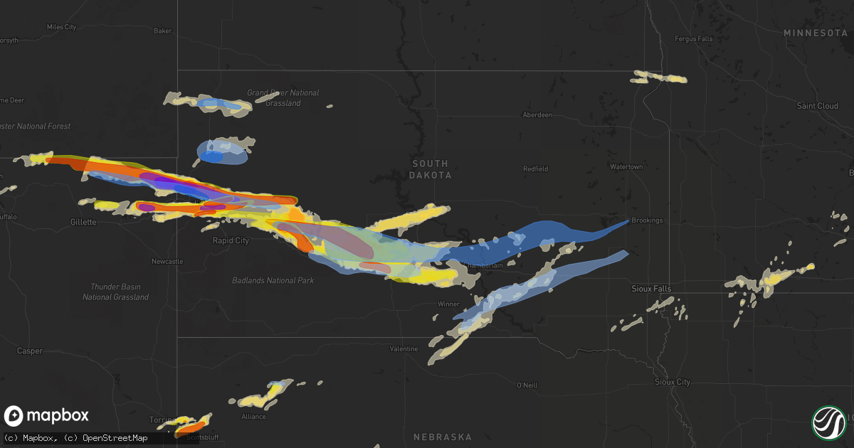
Hail Map in South Dakota on June 12, 2022
Get this storm
June 12 map
$229
one time, instant access
Download today. No call, no setup
Keep the $229
Bought the map and want the full workflow? Apply the entire $229 to a subscription within 7 days. None of it is wasted.
Every map, not just this one
This buys you this map. Subscription and you get every map we run, in the markets you choose from a few cities to whole states to nationwide. Plus real-time alerts the moment a storm fires.
Contact data
Name, contact info, occupancy, even credit band for addresses in the footprint. You go from where it hit to who to call.
Become the source they trust
Unlimited branding weather history reports on demand. You already have the documented answer ready for the property owner, and you are the one who showed up with it.
Property data and RoofTrace estimates
Pull up any address you have got, its value and the exact code rules for that jurisdiction, straight from One Click Code. Then RoofTrace estimates the squares, pitch, and roof value, priced the way you price.
Storm reports in South Dakota
South Dakota
| Date | Description |
|---|---|
| 06/12/20226:56 PM CDT | A local report indicates 1.75 inch wind near 3 NE WHITEWOOD |
| 06/12/20226:26 PM CDT | Also measured 70 mph wind gust. Large branches are down. |
| 06/12/20226:15 PM CDT | Wind gust measured via unl mobile mesonet in rfd |
| 06/12/20226:00 PM CDT | Large tree uprooted |
| 06/12/20226:00 PM CDT | Wind driven baseball to softball size hail. Winds estimated over 75 mph. |
| 06/12/20225:59 PM CDT | Report from belle fourche fire chief. Reports that hail is also getting bigger. |
| 06/12/20227:45 AM CDT | At 1245 AM CDT, severe thunderstorms were located along a line extending from 5 Mile Corner to near Earling Hill to 10 miles northwest of Ideal, moving east at 55 mph. HAZARD...60 mph wind gusts. SOURCE...Radar indicated. IMPACT...Expect damage to roofs, siding, and trees. Locations impacted include... Iona, Lake Francis Case, Oacoma and Dude Ranch. |
| 06/12/20226:53 AM CDT | At 1152 PM CDT, severe thunderstorms were located along a line extending from near Lower Brule to Reliance to near Hamill, moving east at 40 mph. HAZARD...70 mph wind gusts and ping pong ball size hail. SOURCE...Radar indicated. IMPACT...People and animals outdoors will be injured. Expect hail damage to roofs, siding, windows, and vehicles. Expect considerable tree damage. Wind damage is also likely to mobile homes, roofs, and outbuildings. Severe thunderstorms will be near... Lake Francis Case around 1200 AM CDT. Chamberlain around 1210 AM CDT.Other locations in the path of these severe thunderstorms includeKimball and Grass Ranch Colony. |
| 06/12/20226:50 AM CDT | At 1150 PM CDT, severe thunderstorms were located along a line extending from 7 miles east of Grey Goose to 11 miles north of 5 Mile Corner, moving east at 40 mph. HAZARD...60 mph wind gusts and penny size hail. SOURCE...Trained weather spotters. IMPACT...Expect damage to roofs, siding, and trees. Severe thunderstorms will be near... Canning around 1200 AM CDT. Blunt around 1205 AM CDT. Cedar Creek Rec Area around 1210 AM CDT.Other locations in the path of these severe thunderstorms include JoeCreek Rec Area, Harrold, West Bend Rec Area, Lower Brule andHolabird. |
| 06/12/20226:45 AM CDT | At 1144 PM CDT, severe thunderstorms were located along a line extending from near West Bend Rec Area to near Hamill, moving east at 50 mph. HAZARD...Two inch hail and 70 mph wind gusts. SOURCE...Radar indicated. IMPACT...People and animals outdoors will be injured. Expect hail damage to roofs, siding, windows, and vehicles. Expect considerable tree damage. Wind damage is also likely to mobile homes, roofs, and outbuildings. Locations impacted include... Iona and Pleasant Valley Country Church. |
| 06/12/20226:15 AM CDT | At 1114 PM CDT, a severe thunderstorm was located 11 miles north of Mosher, or 21 miles southwest of Presho, moving east at 40 mph. HAZARD...70 mph wind gusts and ping pong ball size hail. SOURCE...Radar indicated. IMPACT...People and animals outdoors will be injured. Expect hail damage to roofs, siding, windows, and vehicles. Expect considerable tree damage. Wind damage is also likely to mobile homes, roofs, and outbuildings. Locations impacted include... Ideal and Hamill. |
| 06/12/20226:03 AM CDT | At 1103 PM MDT, severe thunderstorms were located along a line extending from near Hoover to 3 miles southwest of Newell Lake, moving east at 55 mph. HAZARD...70 mph wind gusts. SOURCE...Radar indicated. IMPACT...Expect considerable tree damage. Damage is likely to mobile homes, roofs, and outbuildings. Severe thunderstorms will be near... Dears Ears Butte around 1110 PM MDT.Other locations in the path of these severe thunderstorms include MudButte, Maurine, Opal, Faith and Durkee Lake. |
| 06/12/20225:52 AM CDT | At 1052 PM CDT/952 PM MDT/, severe thunderstorms were located along a line extending from 12 miles south of Pierre to Mosher, moving east at 40 mph. THESE ARE DESTRUCTIVE STORMS. HAZARD...80 mph wind gusts and tennis ball size hail. SOURCE...Radar indicated. IMPACT...Flying debris will be dangerous to those caught without shelter. Mobile homes will be heavily damaged. Expect considerable damage to roofs, windows, and vehicles. Extensive tree damage and power outages are likely. Severe thunderstorms will be near... Rousseau around 1110 PM CDT.Other locations in the path of these severe thunderstorms includeCedar Creek Rec Area, Degrey Rec Area, Joe Creek Rec Area and WestBend Rec Area. |
| 06/12/20225:38 AM CDT | At 1038 PM MDT, severe thunderstorms were located along a line extending from 6 miles east of Ludlow to 9 miles east of Buffalo to 4 miles southwest of East Short Pines to 4 miles northwest of Antelope Butte, moving east at 65 mph. HAZARD...60 mph wind gusts and quarter size hail. SOURCE...Radar indicated. IMPACT...Hail damage to vehicles is expected. Expect wind damage to roofs, siding, and trees. Severe thunderstorms will be near... Ralph around 1045 PM MDT. Reva and Slim Buttes around 1050 PM MDT. Sorum and Haystack Buttes around 1055 PM MDT.Other locations in the path of these severe thunderstorms includePrairie City, Lodgepole, Hoover, Sheep Buttes, Bison, Zeona,Shadehill Reservoir and Owen Lake. |
| 06/12/20225:26 AM CDT | At 1024 PM CDT, a severe thunderstorm was located over Murdo, moving southeast at 40 mph. THIS IS A DESTRUCTIVE STORM FOR JONES COUNTY. HAZARD...80 mph wind gusts and baseball size hail. SOURCE...Trained weather spotters. At 1015pm, semis were blown over on I90 at 12 miles and 20 miles west of Murdo. IMPACT...Flying debris will be dangerous to those caught without shelter. Mobile homes will be heavily damaged. Expect considerable damage to roofs, windows, and vehicles. Extensive tree damage and power outages are likely. This severe thunderstorm will be near... Draper and Westover around 1035 PM CDT. |
| 06/12/20224:28 AM CDT | At 927 PM CDT/827 PM MDT/, a severe thunderstorm was located near Midland, or 22 miles east of Philip, moving east at 40 mph. HAZARD...Two inch hail and 70 mph wind gusts. SOURCE...Radar indicated. IMPACT...People and animals outdoors will be injured. Expect hail damage to roofs, siding, windows, and vehicles. Expect considerable tree damage. Wind damage is also likely to mobile homes, roofs, and outbuildings. This severe thunderstorm will be near... Capa around 945 PM CDT.Other locations in the path of this severe thunderstorm include Murdoand Draper. |
| 06/12/20224:15 AM CDT | At 914 PM MDT/1014 PM CDT/, a severe thunderstorm was located 9 miles west of Intersection of Highway 83 and White River, or 11 miles northwest of White River, moving east at 40 mph. HAZARD...Tennis ball size hail and 70 mph wind gusts. SOURCE...Radar indicated. IMPACT...People and animals outdoors will be injured. Expect hail damage to roofs, siding, windows, and vehicles. Expect considerable tree damage. Wind damage is also likely to mobile homes, roofs, and outbuildings. This severe thunderstorm will remain over mainly rural areas of central Mellette and eastern Jackson Counties, north of White River.This includes Interstate 90 in South Dakota between Mile Markers 172and 174. |
| 06/12/20224:10 AM CDT | At 909 PM CDT/809 PM MDT/, severe thunderstorms were located along a line extending from 9 miles southwest of Merriman to 8 miles northeast of Ashby, moving northeast at 40 mph. HAZARD...60 mph wind gusts and quarter size hail. SOURCE...Radar indicated. IMPACT...Hail damage to vehicles is expected. Expect wind damage to roofs, siding, and trees. Locations impacted include... Cody, Kilgore, Nenzel, Medicine Lake, Speckel Meir Lake, Eli, Steer Creek Campground, Mother Lake, Cody Lake, Marsh Flat, Round Lake, Hire, and Indian Hill.This includes the following highways... Highway 20 between mile markers 139 and 178. Highway 61 between mile markers 166 and 224. Highway 97 between mile markers 82 and 101. |
| 06/12/20223:14 AM CDT | At 814 PM MDT, a severe thunderstorm was located 4 miles southeast of Elm Springs, or 41 miles east of Rapid City, moving east at 35 mph. HAZARD...60 mph wind gusts and half dollar size hail. SOURCE...Radar indicated. IMPACT...Hail damage to vehicles is expected. Expect wind damage to roofs, siding, and trees. Locations impacted include... Creighton. |
| 06/12/20223:11 AM CDT | At 810 PM MDT/910 PM CDT/, severe thunderstorms were located along a line extending from 4 miles northeast of Ottumwa to 2 miles south of Nowlin to 7 miles southeast of Cactus Flat, moving southeast at 45 mph. HAZARD...Two inch hail and 60 mph wind gusts. SOURCE...Radar indicated. IMPACT...People and animals outdoors will be injured. Expect hail damage to roofs, siding, windows, and vehicles. Expect wind damage to roofs, siding, and trees. Severe thunderstorms will be near... Midland and Nowlin around 815 PM MDT. Intersection of Highway 73 and White River around 825 PM MDT.Other locations in the path of these severe thunderstorms includeNorris, Corn Creek, Black Pipe and Cedar Butte.This includes Interstate 90 in South Dakota between Mile Markers 113and 174. |
| 06/12/20222:31 AM CDT | Mesonet station 209 lowry |
| 06/12/20222:26 AM CDT | A local report indicates 58 MPH wind near 4 S ARLINGTON |
| 06/12/20222:17 AM CDT | At 716 PM MDT, severe thunderstorms were located along a line extending from 8 miles west of Union Center to 3 miles west of Nemo, moving east at 35 mph. HAZARD...Ping pong ball size hail and 60 mph wind gusts. SOURCE...Radar indicated. IMPACT...People and animals outdoors will be injured. Expect hail damage to roofs, siding, windows, and vehicles. Expect wind damage to roofs, siding, and trees. Severe thunderstorms will be near... Union Center and Tilford around 730 PM MDT. Black Hawk around 735 PM MDT.Other locations in the path of these severe thunderstorms includeEnning, White Owl, Ellsworth Air Force Base, northern Box Elder,Plainview, Viewfield and Curlew Lake.This includes Interstate 90 in South Dakota between Mile Markers 39and 53. |
| 06/12/20222:14 AM CDT | At 714 PM MDT, a severe thunderstorm was located 4 miles northwest of Grindstone, or 20 miles northwest of Philip, moving southeast at 40 mph. HAZARD...Two inch hail and 60 mph wind gusts. SOURCE...Radar indicated. IMPACT...People and animals outdoors will be injured. Expect hail damage to roofs, siding, windows, and vehicles. Expect wind damage to roofs, siding, and trees. This severe thunderstorm will be near... Grindstone Butte around 730 PM MDT.Other locations in the path of this severe thunderstorm includePhilip and Nowlin.This includes Interstate 90 in South Dakota between Mile Markers 87and 126, and between Mile Markers 136 and 160. |
| 06/12/20222:02 AM CDT | Mesonet station 178 trail city |
| 06/12/20221:58 AM CDT | At 657 PM MDT, a severe thunderstorm was located near Curlew Lake, or 24 miles northeast of Rapid City, moving east at 30 mph. HAZARD...Golf ball size hail and 60 mph wind gusts. SOURCE...Radar indicated. IMPACT...People and animals outdoors will be injured. Expect hail damage to roofs, siding, windows, and vehicles. Expect wind damage to roofs, siding, and trees. This severe thunderstorm will remain over mainly rural areas of south central Meade and east central Pennington Counties. |
| 06/12/20221:37 AM CDT | Mesonet station 205 mclaughlin |
| 06/12/20221:35 AM CDT | At 635 PM MDT, a severe thunderstorm was located 3 miles southwest of Elm Springs, or 35 miles northeast of Rapid City, moving east at 10 mph. HAZARD...Golf ball size hail and 60 mph wind gusts. SOURCE...Radar indicated. IMPACT...People and animals outdoors will be injured. Expect hail damage to roofs, siding, windows, and vehicles. Expect wind damage to roofs, siding, and trees. This severe thunderstorm will remain over mainly rural areas of southeastern Meade and northeastern Pennington Counties. |
| 06/12/20221:29 AM CDT | A local report indicates 58 MPH wind near 4 SSE MITCHELL |
| 06/12/20221:23 AM CDT | At 623 PM MDT, a severe thunderstorm was located over Apple Springs, or 5 miles west of Sturgis, moving east at 45 mph. HAZARD...Golf ball size hail and 70 mph wind gusts. SOURCE...Radar indicated. IMPACT...People and animals outdoors will be injured. Expect hail damage to roofs, siding, windows, and vehicles. Expect considerable tree damage. Wind damage is also likely to mobile homes, roofs, and outbuildings. This severe thunderstorm will be near... Sturgis and Fort Meade around 630 PM MDT. Bear Butte State Park around 635 PM MDT.This includes Interstate 90 in South Dakota between Mile Markers 14and 41. |
| 06/12/20221:21 AM CDT | Gas station canopy damaged. Time estimated from radar. |
| 06/12/20221:20 AM CDT | A local report indicates 75 MPH wind near LANE |
| 06/12/20221:15 AM CDT | A local report indicates 65 MPH wind near 6 E MOUNT VERNON |
| 06/12/20221:15 AM CDT | A local report indicates 64 MPH wind near LANE |
| 06/12/20221:11 AM CDT | At 610 PM MDT, a severe thunderstorm was located 8 miles north of Hereford, or 31 miles east of Sturgis, moving east at 40 mph. THIS IS A DESTRUCTIVE STORM FOR UNION CENTER AND AREAS NORTH OF HEREFORD. HAZARD...Baseball size hail and 70 mph wind gusts. SOURCE...Radar indicated. IMPACT...People and animals outdoors will be severely injured. Expect shattered windows, extensive damage to roofs, siding, and vehicles. This severe thunderstorm will be near... Union Center around 625 PM MDT. Enning around 630 PM MDT. |
| 06/12/20221:04 AM CDT | A local report indicates 77 MPH wind near 1 NNE FAITH |
| 06/12/202212:59 AM CDT | Personal weather station. |
| 06/12/202212:54 AM CDT | Metal roof panels blown off pole barn. Time estimated from radar. |
| 06/12/202212:50 AM CDT | At 550 PM MDT, a severe thunderstorm was located near Whitewood, or 5 miles northwest of Sturgis, moving east at 35 mph. HAZARD...Ping pong ball size hail and 60 mph wind gusts. SOURCE...Radar indicated. IMPACT...People and animals outdoors will be injured. Expect hail damage to roofs, siding, windows, and vehicles. Expect wind damage to roofs, siding, and trees. This severe thunderstorm will be near... Sturgis and Fort Meade around 555 PM MDT. Bear Butte State Park around 600 PM MDT.This includes Interstate 90 in South Dakota between Mile Markers 21and 35. |
| 06/12/202212:50 AM CDT | Tree branches 1.5 inches in diameter broken off. |
| 06/12/202212:47 AM CDT | At 546 PM MDT, a severe thunderstorm was located 6 miles north of Moskee, or 8 miles east of Sundance, moving east at 40 mph. HAZARD...Golf ball size hail and 70 mph wind gusts. SOURCE...Radar indicated. IMPACT...People and animals outdoors will be injured. Expect hail damage to roofs, siding, windows, and vehicles. Expect considerable tree damage. Wind damage is also likely to mobile homes, roofs, and outbuildings. This severe thunderstorm will be near... Moskee around 550 PM MDT. Cement Ridge Lookout around 555 PM MDT. Roughlock Falls and Iron Creek Lake around 605 PM MDT.Other locations in the path of this severe thunderstorm includeSavoy, O'Neil Pass, Cheyenne Crossing, Terry Peak, Lead, Deadwood,Central City, Brownsville, Galena and Roubaix Lake.This includes Interstate 90 in Wyoming between Mile Markers 180 and203. |
| 06/12/202212:11 AM CDT | A local report indicates 69 MPH wind near 14 W PLATTE |
| 06/12/202212:10 AM CDT | At 509 PM MDT, a severe thunderstorm was located near Fruitdale, or 7 miles east of Belle Fourche, moving east at 50 mph. THIS IS A DESTRUCTIVE STORM FOR FRUITDALE, NISLAND, AND VALE. HAZARD...Softball size hail and 70 mph wind gusts. SOURCE...Radar indicated. IMPACT...People and animals outdoors will be severely injured. Expect shattered windows, extensive damage to roofs, siding, and vehicles. This severe thunderstorm will be near... Nisland around 520 PM MDT. Newell around 525 PM MDT.Other locations in the path of this severe thunderstorm include Vale. |
| 06/12/202212:09 AM CDT | Personal weather station. |
| 06/12/202212:07 AM CDT | Asos station kpir pierre muni ap. |
| 06/12/202212:06 AM CDT | A local report indicates 59 MPH wind near DIXON |
| 06/12/202212:05 AM CDT | A local report indicates 64 MPH wind near 2 W OACOMA |
| 06/12/202212:01 AM CDT | Mesonet station 212 sd rwis agar. |
| 06/11/202211:59 PM CDT | Mesonet station 54 reliance |
| 06/11/202211:58 PM CDT | A local report indicates 59 MPH wind near 7 WSW HOOVER |
| 06/11/202211:56 PM CDT | Report from mping: 1-inch tree limbs broken; shingles blown off. |
| 06/11/202211:50 PM CDT | A local report indicates 73 MPH wind near 12 WSW CASTLE ROCK |
| 06/11/202211:45 PM CDT | A local report indicates 70 MPH wind near 10 W REVA |
| 06/11/202211:41 PM CDT | A local report indicates 84 MPH wind near 8 N REDIG |
| 06/11/202211:30 PM CDT | A local report indicates 1.50 inch wind near 16 N WITTEN |
| 06/11/202211:28 PM CDT | A local report indicates 77 MPH wind near 1 N BUFFALO |
| 06/11/202211:00 PM CDT | Small/large tree branches down. |
| 06/11/202210:30 PM CDT | Extensive wind damage to their area. |
| 06/11/202210:20 PM CDT | Semi tractor trailer blown over on interstate 90. |
| 06/11/202210:15 PM CDT | Semi tractor trailer blown over on interstate 90. |
| 06/11/202210:10 PM CDT | At 310 AM CDT, a severe thunderstorm was located near Westover, or 7 miles southwest of Murdo, moving east at 55 mph. HAZARD...60 mph wind gusts and quarter size hail. SOURCE...Radar indicated. IMPACT...Hail damage to vehicles is expected. Expect wind damage to roofs, siding, and trees. This severe thunderstorm will be near... Westover and Intersection of Highway 83 and White River around 315 AM CDT. |
| 06/11/20229:50 PM CDT | A local report indicates 60 MPH wind near 10 NNE QUINN |
| 06/11/20229:44 PM CDT | At 243 AM CDT, a severe thunderstorm was located 7 miles northwest of Keyapaha, or 22 miles southeast of Mission, moving east at 70 mph. HAZARD...70 mph wind gusts and half dollar size hail. SOURCE...Radar indicated. IMPACT...Hail damage to vehicles is expected. Expect considerable tree damage. Wind damage is also likely to mobile homes, roofs, and outbuildings. This severe thunderstorm will be near... Millboro and Clearfield around 255 AM CDT. Dog Ear Lake around 300 AM CDT.Other locations in the path of this severe thunderstorm includeWewela. |
| 06/11/20229:20 PM CDT | A local report indicates 67 MPH wind near 2 E COTTONWOOD |
| 06/11/20229:16 PM CDT | A local report indicates 61 MPH wind near 4 E CACTUS FLAT |
| 06/11/20229:03 PM CDT | A local report indicates 1.75 inch wind near 6 SSW ELM SPRINGS |
| 06/11/20228:58 PM CDT | At 158 AM CDT, a severe thunderstorm was located over Black Pipe, or 24 miles west of White River, moving east at 55 mph. HAZARD...60 mph wind gusts and quarter size hail. SOURCE...Radar indicated. IMPACT...Hail damage to vehicles is expected. Expect wind damage to roofs, siding, and trees. This severe thunderstorm will be near... Parmelee around 210 AM CDT.Other locations in the path of this severe thunderstorm includeSoldier Creek, Ring Thunder, Mission, Antelope, Haystack Butte,Okreek and Hidden Timber. |
| 06/11/20228:51 PM CDT | A local report indicates 64 MPH wind near 3 NW WASTA |
| 06/11/20228:50 PM CDT | Tornado reported by volunteer fire fighter |
| 06/11/20228:41 PM CDT | A local report indicates 58 MPH wind near 3 NW WASTA |
| 06/11/20228:33 PM CDT | A local report indicates 1.00 inch wind near 12 WSW HEREFORD |
| 06/11/20228:15 PM CDT | A local report indicates 1.00 inch wind near 6 SSW ELM SPRINGS |
| 06/11/20228:15 PM CDT | Minor soffit and gutter damage. |
| 06/11/20228:02 PM CDT | A local report indicates 1.00 inch wind near 1 SSW STURGIS |
| 06/11/20228:00 PM CDT | A local report indicates 1.50 inch wind near 5 E STURGIS |
| 06/11/20227:47 PM CDT | A local report indicates 1.25 inch wind near 7 NNE TILFORD |
| 06/11/20227:47 PM CDT | A local report indicates 1.25 inch wind near 5 NE TILFORD |
| 06/11/20227:45 PM CDT | Heavy damage to roofs and many broken windows. |
| 06/11/20227:45 PM CDT | A local report indicates 4.50 inch wind near 23 N WALL |
| 06/11/20227:45 PM CDT | Golf ball sized hail |
| 06/11/20227:44 PM CDT | A local report indicates 1.75 inch wind near 4 E STURGIS |
| 06/11/20227:42 PM CDT | A local report indicates 1.75 inch wind near 3 ENE STURGIS |
| 06/11/20227:40 PM CDT | A local report indicates 2.00 inch wind near 1 NW STURGIS |
| 06/11/20227:37 PM CDT | A local report indicates 1.50 inch wind near DEADWOOD |
| 06/11/20227:30 PM CDT | A local report indicates 1.25 inch wind near LEAD |
| 06/11/20227:05 PM CDT | A local report indicates 1.00 inch wind near 5 W DWTN SPEARFISH |
All States Impacted by Hail Map on June 12, 2022
Cities Impacted by Hail Map on June 12, 2022
- Prairie City, SD
- Hammond, MT
- Ekalaka, MT
- Reva, SD
- Camp Crook, SD
- Buffalo, SD
- Wessington Springs, SD
- Saint James, MN
- Drayton, ND
- Stephen, MN
- Sturgis, SD
- Piedmont, SD
- Thief River Falls, MN
- Mankato, MN
- Woonsocket, SD
- Moorcroft, WY
- Goodridge, MN
- Davenport, NE
- Rock Rapids, IA
- Alvord, IA
- Doon, IA
- Rock Valley, IA
- Franklin, VA
- Torrington, WY
- Canton, SD
- Arvada, WY
- Decker, MT
- Sheridan, WY
- Otter, MT
- Clearmont, WY
- Salyersville, KY
- Pine Bluffs, WY
- Carpenter, WY
- Burns, WY
- Larchwood, IA
- Inwood, IA
- Worthing, SD
- Harrisburg, SD
- Lennox, SD
- Yuma, CO
- Haxtun, CO
- Otis, CO
- Fleming, CO
- Hebron, NE
- Belleville, KS
- Chester, NE
- Odell, NE
- Diller, NE
- Beatrice, NE
- Garden City, KS
- Irwin, ID
- Swan Valley, ID
- Wilson, WY
- Saint Augustine, IL
- Abingdon, IL
- Berwick, IL
- Butterfield, MN
- Odin, MN
- Bridgeport, NE
- Broadwater, NE
- Cameron, IL
- Monmouth, IL
- Warren, MN
- Herman, MN
- Hankinson, ND
- New Effington, SD
- Sisseton, SD
- Norcross, MN
- Rosholt, SD
- Claire City, SD
- Wheaton, MN
- Mountain Lake, MN
- Middle River, MN
- Grygla, MN
- Newfolden, MN
- Strandquist, MN
- Burke, SD
- Gregory, SD
- Humboldt, TN
- Medina, TN
- Fort Thompson, SD
- Gordon, NE
- Gloucester, VA
- Ogallah, KS
- Wakeeney, KS
- Ellis, KS
- Palco, KS
- Plainville, KS
- Colome, SD
- Dallas, SD
- Quinter, KS
- Collyer, KS
- Utica, KS
- Fairmont, NC
- McIntosh, SD
- Kimball, SD
- Cleveland, MN
- Le Center, MN
- Round Lake, MN
- Leon, IA
- Decatur, IA
- Ellsworth, NE
- Alzada, MT
- Broadus, MT
- Milford, IA
- Belle Fourche, SD
- Lemmon, SD
- Lodgepole, SD
- Ormsby, MN
- Elysian, MN
- Madison Lake, MN
- Everly, IA
- Hartley, IA
- Deadwood, SD
- White Owl, SD
- Owanka, SD
- Witten, SD
- Wall, SD
- Hamill, SD
- Winner, SD
- Presho, SD
- Enning, SD
- New Underwood, SD
- Alva, WY
- Beulah, WY
- Pierre, SD
- Philip, SD
- Midland, SD
- Fort Meade, SD
- Okaton, SD
- Saint Onge, SD
- Reliance, SD
- Spearfish, SD
- Nisland, SD
- Whitewood, SD
- White River, SD
- Newell, SD
- Chamberlain, SD
- Quinn, SD
- Upton, WY
- Harrold, SD
- Belvidere, SD
- Rozet, WY
- Union Center, SD
- Wood, SD
- Blunt, SD
- Vale, SD
- Kennebec, SD
- Ideal, SD
- Gillette, WY
- Lead, SD
- Hulett, WY
- Fort Pierre, SD
- Howes, SD
- Draper, SD
- Vivian, SD
- Kadoka, SD
- Milesville, SD
- Lower Brule, SD
- Wasta, SD
- Aladdin, WY
- Sundance, WY
- Long Valley, SD
- Murdo, SD
- Weston, WY
- Lake Park, IA
- Liverpool, IL
- Forest City, IL
- Lewistown, IL
- Havana, IL
- Topeka, IL
- Canton, IL
- Manito, IL
- Spirit Lake, IA
- Okoboji, IA
- Arnolds Park, IA
- Mitchell, NE
- Harrison, NE
- Morrill, NE
- Veteran, WY
- Scottsbluff, NE
- Lyman, NE
- Alliance, NE
- Meadowlands, MN
- Centerville, SD
- Ogallala, NE
- Venango, NE
- Julesburg, CO
- Holyoke, CO
- Ovid, CO
- Amherst, CO
- Irene, SD
- Viborg, SD
- Avon, IL
- Roseville, IL
- Rushville, IL
- Plymouth, IL
- Camden, IL
- Littleton, IL
- White Lake, SD
- Red Oak, IA
- Essex, IA
- Bayard, NE
- Ahoskie, NC
- Concord, IL
- Jacksonville, IL
- Arenzville, IL
- Fedora, SD
- Saint Peter, MN
- Jackson, WY
- Kelly, WY
- Le Sueur, MN
- Industry, IL
- Vermont, IL
- Pawnee City, NE
- Burchard, NE
- Dighton, KS
- Arnold, NE
- Stapleton, NE
- North Platte, NE
- Brady, NE
- Pinetown, NC
- Pantego, NC
- Plymouth, NC
- Mount Vernon, SD
- Frederick, IL
- Hill City, KS
- Hardy, NE
- Superior, NE
- Banner, WY
- Weldon, IA
- Van Wert, IA
- Akron, CO
- Aulander, NC
- Woodland, NC
- Downs, KS
- Portis, KS
- Osborne, KS
- Lake View, SC
- Nichols, SC
- State Line, IN
- Veedersburg, IN
- Alvin, IL
- Potomac, IL
- Danville, IL
- Henning, IL
- Williamsport, IN
- Covington, IN
- Rossville, IL
- Bismarck, IL
- Gann Valley, SD
- Thomasboro, IL
- Dewey, IL
- Mahomet, IL
- Fisher, IL
- Champaign, IL
- Urbana, IL
- Paxton, NE
- Hays, KS
- Sterling, CO
- Versailles, OH
- Russia, OH
- Astoria, IL
- Nemo, SD
- Mapleton, MN
- Janesville, MN
- Pemberton, MN
- Fairmount, IL
- Dana, IN
- Catlin, IL
- Georgetown, IL
- Ridge Farm, IL
- Cayuga, IN
- Westville, IL
- Merriman, NE
- Winnebago, MN
- Granada, MN
- Truman, MN
- Fairmont, MN
- Willshire, OH
- Monroe, IN
- Decatur, IN
- Rockford, OH
- Geneva, NE
- Springview, NE
- Marston, NC
- Hoffman, NC
- Arlington, CO
- Volin, SD
- Suffolk, VA
- Tryon, NE
- Diagonal, IA
- Healy, KS
- Scott City, KS
- Stickney, SD
- Plankinton, SD
- Arthur, NE
- Jackson, TN
- Oakfield, TN
- Lewiston Woodville, NC
- Kelford, NC
- Scotland Neck, NC
- Bethel Springs, TN
- Gilead, NE
- Shickley, NE
- Belvidere, NE
- Friend, NE
- Daykin, NE
- Carleton, NE
- Fairbury, NE
- Strang, NE
- Milligan, NE
- Ohiowa, NE
- Tobias, NE
- Bruning, NE
- Alexandria, NE
- Republic, KS
- Williamsburg, VA
- Seaford, VA
- Yorktown, VA
- Poquoson, VA
- Newport News, VA
- Las Animas, CO
- Pinson, TN
- Beech Bluff, TN
- Henderson, TN
- Finger, TN
- Conway, NC
- Springfield, OH
- Lakefield, MN
- Worthington, MN
- Okabena, MN
- Mud Butte, SD
- Liberty, NE
- Centralia, KS
- Powhattan, KS
- Baileyville, KS
- Horton, KS
- Blue Springs, NE
- Oneida, KS
- Sabetha, KS
- Fairview, KS
- Oketo, KS
- Axtell, KS
- Wymore, NE
- Summerfield, KS
- Wetmore, KS
- Beattie, KS
- Seneca, KS
- Brewster, MN
- Trimont, MN
- Alpha, MN
- Dunnell, MN
- Sherburn, MN
- Welcome, MN
- Estherville, IA
- Jackson, MN
- Palmyra, IL
- Murrayville, IL
- Girard, IL
- Nilwood, IL
- Modesto, IL
- Waggoner, IL
- Woodson, IL
- Franklin, IL
- Carlinville, IL
- Raymond, IL
- Waverly, IL
- Agate, CO
- Gates, NC
- Dover, NC
- Gaylord, KS
- Lebanon, KS
- Seaboard, NC
- Pendleton, NC
- Margarettsville, NC
- Leoti, KS
- Wilkesville, OH
- Albany, OH
- Langsville, OH
- Vinton, OH
- Ray, OH
- McArthur, OH
- Hamden, OH
- Letcher, SD
- Artesian, SD
- Esbon, KS
- Fort Lee, VA
- Hopewell, VA
- Prince George, VA
- Hay Springs, NE
- Ocheyedan, IA
- Harris, IA
- Davis, SD
- Smith Center, KS
- Athol, KS
- Cedar, KS
- Creola, OH
- Williamston, NC
- Robersonville, NC
- Hemingford, NE
- Marshall, IN
- Bloomingdale, IN
- Kingman, IN
- Roper, NC
- Garysburg, NC
- Gaston, NC
- Mills, NE
- Mitchell, SD
- Herrick, SD
- Johnstown, NE
- Ainsworth, NE
- Platte, SD
- Russellville, IN
- Bainbridge, IN
- Greencastle, IN
- Alton, KS
- Richmond, VA
- Henrico, VA
- Bingham, NE
- Rushville, NE
- Hull, IA
- Carthage, IL
- Marysville, KS
- Lancaster, KS
- Everest, KS
- Barneston, NE
- Hiawatha, KS
- Columbia, VA
- Palmyra, VA
- Scottsville, VA
- New Canton, VA
- Jetersville, VA
- Bremo Bluff, VA
- Powhatan, VA
- Fork Union, VA
- Cartersville, VA
- Cumberland, VA
- Amelia Court House, VA
- Belhaven, NC
- Scranton, NC
- Woodburn, IA
- New Virginia, IA
- Osceola, IA
- Lillington, NC
- Saint Joseph, IL
- Muncie, IL
- Ogden, IL
- Fithian, IL
- Oakwood, IL
- Ransom, KS
- Syracuse, KS
- Kendall, KS
- Walshville, IL
- Sorento, IL
- Hillsboro, IL
- Litchfield, IL
- Greenville, IL
- Panama, IL
- Donnellson, IL
- Thayer, IA
- Holly, CO
- Shannon City, IA
- Lorimor, IA
- Tingley, IA
- Grand River, IA
- Murray, IA
- Ellston, IA
- Afton, IA
- Catharine, KS
- Washington, NC
- Manakin Sabot, VA
- Glen Allen, VA
- Jamesville, NC
- Lakin, KS
- Holcomb, KS
- Bridgewater, IA
- Fontanelle, IA
- Creswell, NC
- Courtland, KS
- Webber, KS
- Woodston, KS
- Burr Oak, KS
- Formoso, KS
- Stockton, KS
- Natoma, KS
- Cawker City, KS
- Mankato, KS
- Jewell, KS
- Kirwin, KS
- Windsor, VA
- Zuni, VA
- South Bloomingville, OH
- Bogue, KS
- Cimarron, KS
- Ingalls, KS
- Butler, IL
- Gillespie, IL
- Winchester, IL
- Sugar City, CO
- Crawfordsville, IN
- Alamo, IN
- Waynetown, IN
- Hobgood, NC
- Oak City, NC
- Roachdale, IN
- Rockville, IN
- Deerfield, KS
- Murfreesboro, NC
- Chesapeake, VA
- Virginia Beach, VA
- Beardstown, IL
- Kensington, KS
- Londonderry, OH
- Granada, CO
- Garden Grove, IA
- Kiowa, CO
- Petersburg, VA
- Disputanta, VA
- Elizabeth City, NC
- Homer, IL
- Colerain, NC
- Ludlow, SD
- Backus, MN
- Hackensack, MN
- Berne, IN
- Capitol, MT
- Blackstone, VA
- Devils Tower, WY
- Box Elder, SD
- Jansen, NE
- Plymouth, NE
- Virginia, NE
- Lewiston, NE
- Arlington, SD
- Alpena, SD
- Oacoma, SD
- Carthage, SD
- Oldham, SD
- Ramona, SD
- Pukwana, SD
- Cavour, SD
- Virgil, SD
- Howard, SD
- Iroquois, SD
- Wessington, SD
- Huron, SD
- Wanblee, SD
- Winfred, SD
- Harrison, SD
- Spencer, SD
- Wentworth, SD
- Fulton, SD
- Alexandria, SD
- Canova, SD
- Corsica, SD
- Salem, SD
- Madison, SD
- Recluse, WY
- Smithboro, IL
- Roodhouse, IL
- Keyesport, IL
- Mulberry Grove, IL
- Hillsdale, IN
- Kinston, NC
- Goff, KS
- Netawaka, KS
- Viking, MN
- Sutherland, NE


