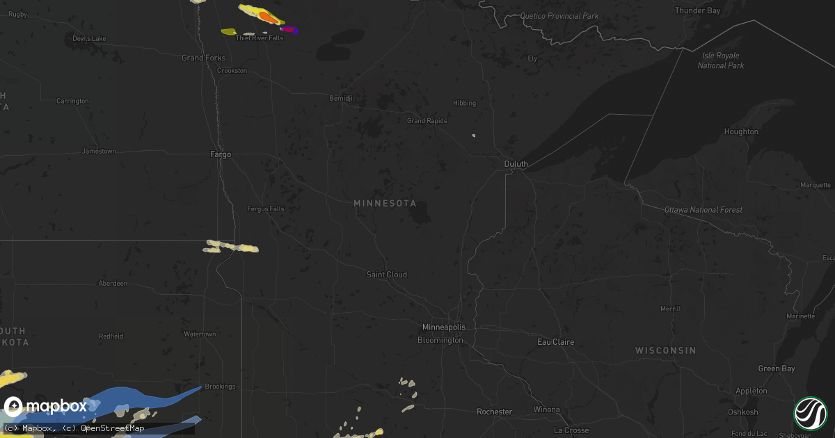
Hail Map in Minnesota on June 12, 2022
Get this storm
June 12 map
$229
one time, instant access
Download today. No call, no setup
Keep the $229
Bought the map and want the full workflow? Apply the entire $229 to a subscription within 7 days. None of it is wasted.
Every map, not just this one
This buys you this map. Subscription and you get every map we run, in the markets you choose from a few cities to whole states to nationwide. Plus real-time alerts the moment a storm fires.
Contact data
Name, contact info, occupancy, even credit band for addresses in the footprint. You go from where it hit to who to call.
Become the source they trust
Unlimited branding weather history reports on demand. You already have the documented answer ready for the property owner, and you are the one who showed up with it.
Property data and RoofTrace estimates
Pull up any address you have got, its value and the exact code rules for that jurisdiction, straight from One Click Code. Then RoofTrace estimates the squares, pitch, and roof value, priced the way you price.
Storm reports in Minnesota
Minnesota
| Date | Description |
|---|---|
| 06/12/20225:10 PM CDT | Report of a tornado from video through broadcast media from a spotter. |
| 06/12/20225:10 PM CDT | Corrects previous tornado report from 6 ene high landing. Report of a tornado from video through broadcast media from a spotter. |
| 06/12/20224:07 PM CDT | Quarter to ping pong sized hail reported by trained weather spotter. Hail was accumulating on ground. |
| 06/12/20224:07 PM CDT | Trained weather spotter reported 65mph wind gusts 7.5 miles northeast of holt. |
| 06/12/20223:53 PM CDT | Deputy reported golf ball sized hail at the cross roads of highway 32 and county road 28. |
| 06/12/202211:22 AM CDT | A local report indicates 1.00 inch wind near 5 SSW RADIUM |
| 06/12/20228:01 AM CDT | Corrects previous hail report from 5 ssw radium. Corrects previous hail report from 5 ssw radium. Corrects previous report due to error in time. |
| 06/12/20223:39 AM CDT | At 839 AM CDT, a severe thunderstorm was located over Carpenters Corner, or 12 miles west of Thief River Falls, moving east at 15 mph. HAZARD...60 mph wind gusts and quarter size hail. SOURCE...Radar indicated. IMPACT...Hail damage to vehicles is expected. Expect wind damage to roofs, siding, and trees. This severe thunderstorm will be near... Viking around 845 AM CDT.Other locations in the path of this severe thunderstorm includeRosewood, Dakota Junction and Thief River Falls. |
| 06/12/20222:58 AM CDT | At 758 AM CDT, a severe thunderstorm was located near Warren, or 24 miles west of Thief River Falls, moving east at 15 mph. HAZARD...60 mph wind gusts and quarter size hail. SOURCE...Radar indicated. IMPACT...Hail damage to vehicles is expected. Expect wind damage to roofs, siding, and trees. This severe thunderstorm will be near... Radium around 810 AM CDT.Other locations in the path of this severe thunderstorm includeCarpenters Corner and Viking. |
| 06/11/202211:59 PM CDT | At 459 PM CDT, a severe thunderstorm was located over northwestern Red Lake Nation, or 33 miles east of Thief River Falls, moving southeast at 25 mph. HAZARD...60 mph wind gusts and half dollar size hail. SOURCE...Radar indicated. IMPACT...Hail damage to vehicles is expected. Expect wind damage to roofs, siding, and trees. This severe thunderstorm will be near... Jelle around 500 PM CDT.Other locations in the path of this severe thunderstorm includesouthwestern Upper Red Lake. |
| 06/11/202211:09 PM CDT | At 408 PM CDT, a severe thunderstorm was located 9 miles east of Holt, or 16 miles northeast of Thief River Falls, moving east at 30 mph. At 407 PM CDT, trained weather spotters reported ping pong ball sized hail 7.5 miles northeast of Holt. HAZARD...Ping pong ball size hail and 60 mph wind gusts. SOURCE...Trained weather spotters. IMPACT...People and animals outdoors will be injured. Expect hail damage to roofs, siding, windows, and vehicles. Expect wind damage to roofs, siding, and trees. Locations impacted include... Espelie, Grygla and Carmel. |
| 06/11/202210:28 PM CDT | At 328 PM CDT, a severe thunderstorm was located near Newfolden, or 20 miles northwest of Thief River Falls, moving southeast at 30 mph. HAZARD...60 mph wind gusts and quarter size hail. SOURCE...Radar indicated. IMPACT...Hail damage to vehicles is expected. Expect wind damage to roofs, siding, and trees. This severe thunderstorm will be near... Newfolden around 335 PM CDT.Other locations in the path of this severe thunderstorm include Holt. |
| 06/11/202210:00 PM CDT | At 259 PM CDT, a severe thunderstorm was located near Long Point, or 36 miles northeast of Roseau, moving southeast at 25 mph. HAZARD...60 mph wind gusts and quarter size hail. SOURCE...Radar indicated. IMPACT...Hail damage to vehicles is expected. Expect wind damage to roofs, siding, and trees. This severe thunderstorm will be near... Long Point and Lude around 310 PM CDT. Birch Beach around 315 PM CDT.Other locations in the path of this severe thunderstorm includeWheelers Point. |
| 06/11/20229:14 PM CDT | At 213 PM CDT, a severe thunderstorm was located 13 miles north of Longworth, or 25 miles northeast of Roseau, moving east at 30 mph. HAZARD...70 mph wind gusts and half dollar size hail. SOURCE...Radar indicated. IMPACT...Hail damage to vehicles is expected. Expect considerable tree damage. Wind damage is also likely to mobile homes, roofs, and outbuildings. Locations impacted include... Long Point, Lude and Birch Beach, Lake of the Woods, Warroad. |
All States Impacted by Hail Map on June 12, 2022
Cities Impacted by Hail Map on June 12, 2022
- Prairie City, SD
- Hammond, MT
- Ekalaka, MT
- Reva, SD
- Camp Crook, SD
- Buffalo, SD
- Wessington Springs, SD
- Saint James, MN
- Drayton, ND
- Stephen, MN
- Sturgis, SD
- Piedmont, SD
- Thief River Falls, MN
- Mankato, MN
- Woonsocket, SD
- Moorcroft, WY
- Goodridge, MN
- Davenport, NE
- Rock Rapids, IA
- Alvord, IA
- Doon, IA
- Rock Valley, IA
- Franklin, VA
- Torrington, WY
- Canton, SD
- Arvada, WY
- Decker, MT
- Sheridan, WY
- Otter, MT
- Clearmont, WY
- Salyersville, KY
- Pine Bluffs, WY
- Carpenter, WY
- Burns, WY
- Larchwood, IA
- Inwood, IA
- Worthing, SD
- Harrisburg, SD
- Lennox, SD
- Yuma, CO
- Haxtun, CO
- Otis, CO
- Fleming, CO
- Hebron, NE
- Belleville, KS
- Chester, NE
- Odell, NE
- Diller, NE
- Beatrice, NE
- Garden City, KS
- Irwin, ID
- Swan Valley, ID
- Wilson, WY
- Saint Augustine, IL
- Abingdon, IL
- Berwick, IL
- Butterfield, MN
- Odin, MN
- Bridgeport, NE
- Broadwater, NE
- Cameron, IL
- Monmouth, IL
- Warren, MN
- Herman, MN
- Hankinson, ND
- New Effington, SD
- Sisseton, SD
- Norcross, MN
- Rosholt, SD
- Claire City, SD
- Wheaton, MN
- Mountain Lake, MN
- Middle River, MN
- Grygla, MN
- Newfolden, MN
- Strandquist, MN
- Burke, SD
- Gregory, SD
- Humboldt, TN
- Medina, TN
- Fort Thompson, SD
- Gordon, NE
- Gloucester, VA
- Ogallah, KS
- Wakeeney, KS
- Ellis, KS
- Palco, KS
- Plainville, KS
- Colome, SD
- Dallas, SD
- Quinter, KS
- Collyer, KS
- Utica, KS
- Fairmont, NC
- McIntosh, SD
- Kimball, SD
- Cleveland, MN
- Le Center, MN
- Round Lake, MN
- Leon, IA
- Decatur, IA
- Ellsworth, NE
- Alzada, MT
- Broadus, MT
- Milford, IA
- Belle Fourche, SD
- Lemmon, SD
- Lodgepole, SD
- Ormsby, MN
- Elysian, MN
- Madison Lake, MN
- Everly, IA
- Hartley, IA
- Deadwood, SD
- White Owl, SD
- Owanka, SD
- Witten, SD
- Wall, SD
- Hamill, SD
- Winner, SD
- Presho, SD
- Enning, SD
- New Underwood, SD
- Alva, WY
- Beulah, WY
- Pierre, SD
- Philip, SD
- Midland, SD
- Fort Meade, SD
- Okaton, SD
- Saint Onge, SD
- Reliance, SD
- Spearfish, SD
- Nisland, SD
- Whitewood, SD
- White River, SD
- Newell, SD
- Chamberlain, SD
- Quinn, SD
- Upton, WY
- Harrold, SD
- Belvidere, SD
- Rozet, WY
- Union Center, SD
- Wood, SD
- Blunt, SD
- Vale, SD
- Kennebec, SD
- Ideal, SD
- Gillette, WY
- Lead, SD
- Hulett, WY
- Fort Pierre, SD
- Howes, SD
- Draper, SD
- Vivian, SD
- Kadoka, SD
- Milesville, SD
- Lower Brule, SD
- Wasta, SD
- Aladdin, WY
- Sundance, WY
- Long Valley, SD
- Murdo, SD
- Weston, WY
- Lake Park, IA
- Liverpool, IL
- Forest City, IL
- Lewistown, IL
- Havana, IL
- Topeka, IL
- Canton, IL
- Manito, IL
- Spirit Lake, IA
- Okoboji, IA
- Arnolds Park, IA
- Mitchell, NE
- Harrison, NE
- Morrill, NE
- Veteran, WY
- Scottsbluff, NE
- Lyman, NE
- Alliance, NE
- Meadowlands, MN
- Centerville, SD
- Ogallala, NE
- Venango, NE
- Julesburg, CO
- Holyoke, CO
- Ovid, CO
- Amherst, CO
- Irene, SD
- Viborg, SD
- Avon, IL
- Roseville, IL
- Rushville, IL
- Plymouth, IL
- Camden, IL
- Littleton, IL
- White Lake, SD
- Red Oak, IA
- Essex, IA
- Bayard, NE
- Ahoskie, NC
- Concord, IL
- Jacksonville, IL
- Arenzville, IL
- Fedora, SD
- Saint Peter, MN
- Jackson, WY
- Kelly, WY
- Le Sueur, MN
- Industry, IL
- Vermont, IL
- Pawnee City, NE
- Burchard, NE
- Dighton, KS
- Arnold, NE
- Stapleton, NE
- North Platte, NE
- Brady, NE
- Pinetown, NC
- Pantego, NC
- Plymouth, NC
- Mount Vernon, SD
- Frederick, IL
- Hill City, KS
- Hardy, NE
- Superior, NE
- Banner, WY
- Weldon, IA
- Van Wert, IA
- Akron, CO
- Aulander, NC
- Woodland, NC
- Downs, KS
- Portis, KS
- Osborne, KS
- Lake View, SC
- Nichols, SC
- State Line, IN
- Veedersburg, IN
- Alvin, IL
- Potomac, IL
- Danville, IL
- Henning, IL
- Williamsport, IN
- Covington, IN
- Rossville, IL
- Bismarck, IL
- Gann Valley, SD
- Thomasboro, IL
- Dewey, IL
- Mahomet, IL
- Fisher, IL
- Champaign, IL
- Urbana, IL
- Paxton, NE
- Hays, KS
- Sterling, CO
- Versailles, OH
- Russia, OH
- Astoria, IL
- Nemo, SD
- Mapleton, MN
- Janesville, MN
- Pemberton, MN
- Fairmount, IL
- Dana, IN
- Catlin, IL
- Georgetown, IL
- Ridge Farm, IL
- Cayuga, IN
- Westville, IL
- Merriman, NE
- Winnebago, MN
- Granada, MN
- Truman, MN
- Fairmont, MN
- Willshire, OH
- Monroe, IN
- Decatur, IN
- Rockford, OH
- Geneva, NE
- Springview, NE
- Marston, NC
- Hoffman, NC
- Arlington, CO
- Volin, SD
- Suffolk, VA
- Tryon, NE
- Diagonal, IA
- Healy, KS
- Scott City, KS
- Stickney, SD
- Plankinton, SD
- Arthur, NE
- Jackson, TN
- Oakfield, TN
- Lewiston Woodville, NC
- Kelford, NC
- Scotland Neck, NC
- Bethel Springs, TN
- Gilead, NE
- Shickley, NE
- Belvidere, NE
- Friend, NE
- Daykin, NE
- Carleton, NE
- Fairbury, NE
- Strang, NE
- Milligan, NE
- Ohiowa, NE
- Tobias, NE
- Bruning, NE
- Alexandria, NE
- Republic, KS
- Williamsburg, VA
- Seaford, VA
- Yorktown, VA
- Poquoson, VA
- Newport News, VA
- Las Animas, CO
- Pinson, TN
- Beech Bluff, TN
- Henderson, TN
- Finger, TN
- Conway, NC
- Springfield, OH
- Lakefield, MN
- Worthington, MN
- Okabena, MN
- Mud Butte, SD
- Liberty, NE
- Centralia, KS
- Powhattan, KS
- Baileyville, KS
- Horton, KS
- Blue Springs, NE
- Oneida, KS
- Sabetha, KS
- Fairview, KS
- Oketo, KS
- Axtell, KS
- Wymore, NE
- Summerfield, KS
- Wetmore, KS
- Beattie, KS
- Seneca, KS
- Brewster, MN
- Trimont, MN
- Alpha, MN
- Dunnell, MN
- Sherburn, MN
- Welcome, MN
- Estherville, IA
- Jackson, MN
- Palmyra, IL
- Murrayville, IL
- Girard, IL
- Nilwood, IL
- Modesto, IL
- Waggoner, IL
- Woodson, IL
- Franklin, IL
- Carlinville, IL
- Raymond, IL
- Waverly, IL
- Agate, CO
- Gates, NC
- Dover, NC
- Gaylord, KS
- Lebanon, KS
- Seaboard, NC
- Pendleton, NC
- Margarettsville, NC
- Leoti, KS
- Wilkesville, OH
- Albany, OH
- Langsville, OH
- Vinton, OH
- Ray, OH
- McArthur, OH
- Hamden, OH
- Letcher, SD
- Artesian, SD
- Esbon, KS
- Fort Lee, VA
- Hopewell, VA
- Prince George, VA
- Hay Springs, NE
- Ocheyedan, IA
- Harris, IA
- Davis, SD
- Smith Center, KS
- Athol, KS
- Cedar, KS
- Creola, OH
- Williamston, NC
- Robersonville, NC
- Hemingford, NE
- Marshall, IN
- Bloomingdale, IN
- Kingman, IN
- Roper, NC
- Garysburg, NC
- Gaston, NC
- Mills, NE
- Mitchell, SD
- Herrick, SD
- Johnstown, NE
- Ainsworth, NE
- Platte, SD
- Russellville, IN
- Bainbridge, IN
- Greencastle, IN
- Alton, KS
- Richmond, VA
- Henrico, VA
- Bingham, NE
- Rushville, NE
- Hull, IA
- Carthage, IL
- Marysville, KS
- Lancaster, KS
- Everest, KS
- Barneston, NE
- Hiawatha, KS
- Columbia, VA
- Palmyra, VA
- Scottsville, VA
- New Canton, VA
- Jetersville, VA
- Bremo Bluff, VA
- Powhatan, VA
- Fork Union, VA
- Cartersville, VA
- Cumberland, VA
- Amelia Court House, VA
- Belhaven, NC
- Scranton, NC
- Woodburn, IA
- New Virginia, IA
- Osceola, IA
- Lillington, NC
- Saint Joseph, IL
- Muncie, IL
- Ogden, IL
- Fithian, IL
- Oakwood, IL
- Ransom, KS
- Syracuse, KS
- Kendall, KS
- Walshville, IL
- Sorento, IL
- Hillsboro, IL
- Litchfield, IL
- Greenville, IL
- Panama, IL
- Donnellson, IL
- Thayer, IA
- Holly, CO
- Shannon City, IA
- Lorimor, IA
- Tingley, IA
- Grand River, IA
- Murray, IA
- Ellston, IA
- Afton, IA
- Catharine, KS
- Washington, NC
- Manakin Sabot, VA
- Glen Allen, VA
- Jamesville, NC
- Lakin, KS
- Holcomb, KS
- Bridgewater, IA
- Fontanelle, IA
- Creswell, NC
- Courtland, KS
- Webber, KS
- Woodston, KS
- Burr Oak, KS
- Formoso, KS
- Stockton, KS
- Natoma, KS
- Cawker City, KS
- Mankato, KS
- Jewell, KS
- Kirwin, KS
- Windsor, VA
- Zuni, VA
- South Bloomingville, OH
- Bogue, KS
- Cimarron, KS
- Ingalls, KS
- Butler, IL
- Gillespie, IL
- Winchester, IL
- Sugar City, CO
- Crawfordsville, IN
- Alamo, IN
- Waynetown, IN
- Hobgood, NC
- Oak City, NC
- Roachdale, IN
- Rockville, IN
- Deerfield, KS
- Murfreesboro, NC
- Chesapeake, VA
- Virginia Beach, VA
- Beardstown, IL
- Kensington, KS
- Londonderry, OH
- Granada, CO
- Garden Grove, IA
- Kiowa, CO
- Petersburg, VA
- Disputanta, VA
- Elizabeth City, NC
- Homer, IL
- Colerain, NC
- Ludlow, SD
- Backus, MN
- Hackensack, MN
- Berne, IN
- Capitol, MT
- Blackstone, VA
- Devils Tower, WY
- Box Elder, SD
- Jansen, NE
- Plymouth, NE
- Virginia, NE
- Lewiston, NE
- Arlington, SD
- Alpena, SD
- Oacoma, SD
- Carthage, SD
- Oldham, SD
- Ramona, SD
- Pukwana, SD
- Cavour, SD
- Virgil, SD
- Howard, SD
- Iroquois, SD
- Wessington, SD
- Huron, SD
- Wanblee, SD
- Winfred, SD
- Harrison, SD
- Spencer, SD
- Wentworth, SD
- Fulton, SD
- Alexandria, SD
- Canova, SD
- Corsica, SD
- Salem, SD
- Madison, SD
- Recluse, WY
- Smithboro, IL
- Roodhouse, IL
- Keyesport, IL
- Mulberry Grove, IL
- Hillsdale, IN
- Kinston, NC
- Goff, KS
- Netawaka, KS
- Viking, MN
- Sutherland, NE


