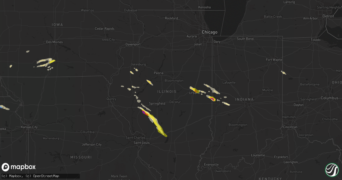
Hail Map in Illinois on June 12, 2022
Get this storm
June 12 map
$229
one time, instant access
Download today. No call, no setup
Keep the $229
Bought the map and want the full workflow? Apply the entire $229 to a subscription within 7 days. None of it is wasted.
Every map, not just this one
This buys you this map. Subscription and you get every map we run, in the markets you choose from a few cities to whole states to nationwide. Plus real-time alerts the moment a storm fires.
Contact data
Name, contact info, occupancy, even credit band for addresses in the footprint. You go from where it hit to who to call.
Become the source they trust
Unlimited branding weather history reports on demand. You already have the documented answer ready for the property owner, and you are the one who showed up with it.
Property data and RoofTrace estimates
Pull up any address you have got, its value and the exact code rules for that jurisdiction, straight from One Click Code. Then RoofTrace estimates the squares, pitch, and roof value, priced the way you price.
Storm reports in Illinois
Illinois
| Date | Description |
|---|---|
| 06/12/202210:45 AM CDT | A local report indicates 1.00 inch wind near LITCHFIELD |
| 06/12/202210:43 AM CDT | A local report indicates 1.00 inch wind near 2 W LITCHFIELD |
| 06/12/202210:30 AM CDT | Macoupin county sheriffs office reported trees down east of carlinville. Time estimated from radar. |
| 06/12/202210:29 AM CDT | Machine shed destroyed on dickey road... With debris blown approximately a 1/4 mile to the east/southeast. Winds estimated to be 60-70 mph. Time estimated from radar. |
| 06/12/202210:29 AM CDT | Corrects previous tstm wnd dmg report from 4 s atwater. Camper flipped over on route 108 near atwater road. Time estimated from radar. Facebook report. |
| 06/12/202210:29 AM CDT | Power poles down on barnett road between leefers and south atwater roads. Time estimated from radar. |
| 06/12/202210:28 AM CDT | Corrects previous tstm wnd dmg report from 4 sw atwater. Corrects previous tstm wnd dmg report from 4 sw atwater. Several trees uprooted/snapped near intersection of ki |
| 06/12/202210:28 AM CDT | Corrects previous tstm wnd dmg report from 4 sw atwater. Several trees uprooted/snapped near intersection of kirkland and sumter roads. Time estimated from radar. Faceb |
| 06/12/202210:28 AM CDT | Tree down blocking route 108 one mile east of standard city rd. |
| 06/12/202210:25 AM CDT | Twitter report sent at 10:25. |
| 06/12/202210:25 AM CDT | Corrects previous hail report from modesto. Twitter report sent at 10:25. |
| 06/12/202210:25 AM CDT | Pictures via twitter of multiple small to medium-size trees snapped. Noted that the tree damage was in a narrow area. |
| 06/12/202210:25 AM CDT | Camper flipped over on route 108 near atwater road. Time estimated from radar. Facebook report. |
| 06/12/202210:25 AM CDT | Via facebook picture--damage to car windshield. |
| 06/12/202210:24 AM CDT | Several trees uprooted/snapped near intersection of kirkland and sumter roads. Time estimated from radar. Facebook report. |
| 06/12/202210:12 AM CDT | Photo of oblong quarter-size hail sent to media partner. |
| 06/12/202210:00 AM CDT | Sheriffs office in macoupin county reported trees down in the otter lake area west of girard. |
| 06/12/20229:30 AM CDT | Report of trees down. |
| 06/12/20229:30 AM CDT | Nearby crops beaten down... Skylight knocked out. Relayed via weather channel storm chaser. |
| 06/12/20229:30 AM CDT | Wind estimate based off of remote tree damage assessment from pictures and video. |
| 06/12/20228:50 AM CDT | 6 inch limb down. Time estimated from radar. |
| 06/12/20228:09 AM CDT | Pine tree snapped half way up... Time estimated from radar. |
| 06/12/20228:08 AM CDT | Part of barn roof blown off. Report relayed by broadcast media. Time of the event is estimated using radar. |
| 06/12/20227:55 AM CDT | Quarter size hail just north of town. |
| 06/12/20227:40 AM CDT | Tree damage on leverett road. |
| 06/12/20227:40 AM CDT | Damage to grain elevator. Winds estimated at 60mph. Corner of leverett road and county road 1350. |
| 06/12/20227:40 AM CDT | A local report indicates 1.50 inch wind near 1 N URBANA |
| 06/12/20227:40 AM CDT | Outbuilding destroyed. |
| 06/12/20227:09 AM CDT | Delayed report. Time estimated from radar. Also report of crop and tree damage. |
| 06/12/20226:14 AM CDT | At 1113 AM CDT, a severe thunderstorm was located over Reno, moving southeast at 35 mph. HAZARD...60 mph wind gusts and quarter size hail. SOURCE...Radar indicated. IMPACT...Hail damage to vehicles is expected. Expect wind damage to roofs, siding, and trees. This severe thunderstorm will be near... Greenville and Pocahontas around 1125 AM CDT.Other locations in the path of this severe thunderstorm includeBeaver Creek and Tamalco.This includes Interstate 70 in Illinois between exits 36 and 45. |
| 06/12/20225:43 AM CDT | At 1043 AM CDT, a severe thunderstorm was located over Litchfield, moving southeast at 35 mph. HAZARD...Ping pong ball size hail and 60 mph wind gusts. SOURCE...Radar indicated. IMPACT...People and animals outdoors will be injured. Expect hail damage to roofs, siding, windows, and vehicles. Expect wind damage to roofs, siding, and trees. This severe thunderstorm will be near... Taylor Springs around 1055 AM CDT.Other locations in the path of this severe thunderstorm includeSorento, Reno and Woburn.This includes Interstate 55 in Illinois between exits 41 and 52. This also includes Lake Lou Yaeger. |
| 06/12/20225:17 AM CDT | At 1016 AM EDT, a severe thunderstorm was located near Georgetown, or 12 miles southeast of Danville, moving southeast at 15 mph. HAZARD...60 mph wind gusts and quarter size hail. SOURCE...Radar indicated. IMPACT...Hail damage to vehicles is expected. Expect wind damage to roofs, siding, and trees. This severe thunderstorm will be near... Perrysville around 1025 AM EDT. Cayuga around 1030 AM EDT.Other locations in the path of this severe thunderstorm include Lodi,Newport, Montezuma and Kingman. |
| 06/12/20225:14 AM CDT | At 1014 AM CDT, a severe thunderstorm was located near Girard, moving southeast at 25 mph. HAZARD...Ping pong ball size hail and 60 mph wind gusts. SOURCE...Radar indicated. IMPACT...People and animals outdoors will be injured. Expect hail damage to roofs, siding, windows, and vehicles. Expect wind damage to roofs, siding, and trees. Locations impacted include... Raymond and Litchfield.This includes Interstate 55 in Illinois between exits 52 and 63. This also includes Lake Lou Yaeger. |
| 06/12/20224:25 AM CDT | At 925 AM CDT, a severe thunderstorm was located near Franklin, moving southeast at 35 mph. HAZARD...Ping pong ball size hail and 60 mph wind gusts. SOURCE...Radar indicated. IMPACT...People and animals outdoors will be injured. Expect hail damage to roofs, siding, windows, and vehicles. Expect wind damage to roofs, siding, and trees. Locations impacted include... Virden and Girard. |
| 06/12/20224:23 AM CDT | At 923 AM CDT, a severe thunderstorm was located near Woodson, or 8 miles southeast of Jacksonville, moving east at 35 mph. HAZARD...60 mph wind gusts and quarter size hail. SOURCE...Radar indicated. IMPACT...Hail damage to vehicles is expected. Expect wind damage to roofs, siding, and trees. This severe thunderstorm will be near... Franklin around 930 AM CDT. Waverly around 940 AM CDT. Auburn around 1000 AM CDT.Other locations impacted by this severe thunderstorm includeNortonville and Lowder. |
| 06/12/20223:55 AM CDT | At 855 AM CDT, a severe thunderstorm was located near Arenzville, or 7 miles southwest of Virginia, moving southeast at 30 mph. HAZARD...60 mph wind gusts and quarter size hail. SOURCE...Radar indicated. IMPACT...Hail damage to vehicles is expected. Expect wind damage to roofs, siding, and trees. This severe thunderstorm will be near... Literberry around 900 AM CDT. Jacksonville around 910 AM CDT. Alexander around 925 AM CDT. Franklin around 930 AM CDT.Other locations impacted by this severe thunderstorm includeNortonville, Sinclair, South Jacksonville, Jacksonville MunicipalAirport, Berlin, Concord and Lake Jacksonville.This includes Interstate 72 between mile markers 61 and 85. |
| 06/12/20222:31 AM CDT | At 730 AM CDT, a severe thunderstorm was located near Thomasboro, or near Champaign, moving southeast at 25 mph. HAZARD...60 mph wind gusts and quarter size hail. SOURCE...Radar indicated. IMPACT...Hail damage to vehicles is expected. Expect wind damage to roofs, siding, and trees. This severe thunderstorm will be near... Urbana around 735 AM CDT.Other locations in the path of this severe thunderstorm include St.Joseph, Sidney, Ogden and Homer.This includes the following highways... Interstate 57 between mile markers 239 and 247. Interstate 74 between mile markers 182 and 197. |
| 06/11/20228:13 PM CDT | At 113 AM CDT, a severe thunderstorm was located over Osco, or near Cambridge, moving southeast at 25 mph. HAZARD...60 mph wind gusts and quarter size hail. SOURCE...Radar indicated. IMPACT...Hail damage to vehicles is expected. Expect wind damage to roofs, siding, and trees. This severe thunderstorm will be near... Cambridge and Henry County Fairgrounds around 125 AM CDT. Ulah around 130 AM CDT.Other locations in the path of this severe thunderstorm includeBishop Hill, German Corner, Nekoma, Galva, Kewanee and KewaneeMunicipal Airport. |
All States Impacted by Hail Map on June 12, 2022
Cities Impacted by Hail Map on June 12, 2022
- Prairie City, SD
- Hammond, MT
- Ekalaka, MT
- Reva, SD
- Camp Crook, SD
- Buffalo, SD
- Wessington Springs, SD
- Saint James, MN
- Drayton, ND
- Stephen, MN
- Sturgis, SD
- Piedmont, SD
- Thief River Falls, MN
- Mankato, MN
- Woonsocket, SD
- Moorcroft, WY
- Goodridge, MN
- Davenport, NE
- Rock Rapids, IA
- Alvord, IA
- Doon, IA
- Rock Valley, IA
- Franklin, VA
- Torrington, WY
- Canton, SD
- Arvada, WY
- Decker, MT
- Sheridan, WY
- Otter, MT
- Clearmont, WY
- Salyersville, KY
- Pine Bluffs, WY
- Carpenter, WY
- Burns, WY
- Larchwood, IA
- Inwood, IA
- Worthing, SD
- Harrisburg, SD
- Lennox, SD
- Yuma, CO
- Haxtun, CO
- Otis, CO
- Fleming, CO
- Hebron, NE
- Belleville, KS
- Chester, NE
- Odell, NE
- Diller, NE
- Beatrice, NE
- Garden City, KS
- Irwin, ID
- Swan Valley, ID
- Wilson, WY
- Saint Augustine, IL
- Abingdon, IL
- Berwick, IL
- Butterfield, MN
- Odin, MN
- Bridgeport, NE
- Broadwater, NE
- Cameron, IL
- Monmouth, IL
- Warren, MN
- Herman, MN
- Hankinson, ND
- New Effington, SD
- Sisseton, SD
- Norcross, MN
- Rosholt, SD
- Claire City, SD
- Wheaton, MN
- Mountain Lake, MN
- Middle River, MN
- Grygla, MN
- Newfolden, MN
- Strandquist, MN
- Burke, SD
- Gregory, SD
- Humboldt, TN
- Medina, TN
- Fort Thompson, SD
- Gordon, NE
- Gloucester, VA
- Ogallah, KS
- Wakeeney, KS
- Ellis, KS
- Palco, KS
- Plainville, KS
- Colome, SD
- Dallas, SD
- Quinter, KS
- Collyer, KS
- Utica, KS
- Fairmont, NC
- McIntosh, SD
- Kimball, SD
- Cleveland, MN
- Le Center, MN
- Round Lake, MN
- Leon, IA
- Decatur, IA
- Ellsworth, NE
- Alzada, MT
- Broadus, MT
- Milford, IA
- Belle Fourche, SD
- Lemmon, SD
- Lodgepole, SD
- Ormsby, MN
- Elysian, MN
- Madison Lake, MN
- Everly, IA
- Hartley, IA
- Deadwood, SD
- White Owl, SD
- Owanka, SD
- Witten, SD
- Wall, SD
- Hamill, SD
- Winner, SD
- Presho, SD
- Enning, SD
- New Underwood, SD
- Alva, WY
- Beulah, WY
- Pierre, SD
- Philip, SD
- Midland, SD
- Fort Meade, SD
- Okaton, SD
- Saint Onge, SD
- Reliance, SD
- Spearfish, SD
- Nisland, SD
- Whitewood, SD
- White River, SD
- Newell, SD
- Chamberlain, SD
- Quinn, SD
- Upton, WY
- Harrold, SD
- Belvidere, SD
- Rozet, WY
- Union Center, SD
- Wood, SD
- Blunt, SD
- Vale, SD
- Kennebec, SD
- Ideal, SD
- Gillette, WY
- Lead, SD
- Hulett, WY
- Fort Pierre, SD
- Howes, SD
- Draper, SD
- Vivian, SD
- Kadoka, SD
- Milesville, SD
- Lower Brule, SD
- Wasta, SD
- Aladdin, WY
- Sundance, WY
- Long Valley, SD
- Murdo, SD
- Weston, WY
- Lake Park, IA
- Liverpool, IL
- Forest City, IL
- Lewistown, IL
- Havana, IL
- Topeka, IL
- Canton, IL
- Manito, IL
- Spirit Lake, IA
- Okoboji, IA
- Arnolds Park, IA
- Mitchell, NE
- Harrison, NE
- Morrill, NE
- Veteran, WY
- Scottsbluff, NE
- Lyman, NE
- Alliance, NE
- Meadowlands, MN
- Centerville, SD
- Ogallala, NE
- Venango, NE
- Julesburg, CO
- Holyoke, CO
- Ovid, CO
- Amherst, CO
- Irene, SD
- Viborg, SD
- Avon, IL
- Roseville, IL
- Rushville, IL
- Plymouth, IL
- Camden, IL
- Littleton, IL
- White Lake, SD
- Red Oak, IA
- Essex, IA
- Bayard, NE
- Ahoskie, NC
- Concord, IL
- Jacksonville, IL
- Arenzville, IL
- Fedora, SD
- Saint Peter, MN
- Jackson, WY
- Kelly, WY
- Le Sueur, MN
- Industry, IL
- Vermont, IL
- Pawnee City, NE
- Burchard, NE
- Dighton, KS
- Arnold, NE
- Stapleton, NE
- North Platte, NE
- Brady, NE
- Pinetown, NC
- Pantego, NC
- Plymouth, NC
- Mount Vernon, SD
- Frederick, IL
- Hill City, KS
- Hardy, NE
- Superior, NE
- Banner, WY
- Weldon, IA
- Van Wert, IA
- Akron, CO
- Aulander, NC
- Woodland, NC
- Downs, KS
- Portis, KS
- Osborne, KS
- Lake View, SC
- Nichols, SC
- State Line, IN
- Veedersburg, IN
- Alvin, IL
- Potomac, IL
- Danville, IL
- Henning, IL
- Williamsport, IN
- Covington, IN
- Rossville, IL
- Bismarck, IL
- Gann Valley, SD
- Thomasboro, IL
- Dewey, IL
- Mahomet, IL
- Fisher, IL
- Champaign, IL
- Urbana, IL
- Paxton, NE
- Hays, KS
- Sterling, CO
- Versailles, OH
- Russia, OH
- Astoria, IL
- Nemo, SD
- Mapleton, MN
- Janesville, MN
- Pemberton, MN
- Fairmount, IL
- Dana, IN
- Catlin, IL
- Georgetown, IL
- Ridge Farm, IL
- Cayuga, IN
- Westville, IL
- Merriman, NE
- Winnebago, MN
- Granada, MN
- Truman, MN
- Fairmont, MN
- Willshire, OH
- Monroe, IN
- Decatur, IN
- Rockford, OH
- Geneva, NE
- Springview, NE
- Marston, NC
- Hoffman, NC
- Arlington, CO
- Volin, SD
- Suffolk, VA
- Tryon, NE
- Diagonal, IA
- Healy, KS
- Scott City, KS
- Stickney, SD
- Plankinton, SD
- Arthur, NE
- Jackson, TN
- Oakfield, TN
- Lewiston Woodville, NC
- Kelford, NC
- Scotland Neck, NC
- Bethel Springs, TN
- Gilead, NE
- Shickley, NE
- Belvidere, NE
- Friend, NE
- Daykin, NE
- Carleton, NE
- Fairbury, NE
- Strang, NE
- Milligan, NE
- Ohiowa, NE
- Tobias, NE
- Bruning, NE
- Alexandria, NE
- Republic, KS
- Williamsburg, VA
- Seaford, VA
- Yorktown, VA
- Poquoson, VA
- Newport News, VA
- Las Animas, CO
- Pinson, TN
- Beech Bluff, TN
- Henderson, TN
- Finger, TN
- Conway, NC
- Springfield, OH
- Lakefield, MN
- Worthington, MN
- Okabena, MN
- Mud Butte, SD
- Liberty, NE
- Centralia, KS
- Powhattan, KS
- Baileyville, KS
- Horton, KS
- Blue Springs, NE
- Oneida, KS
- Sabetha, KS
- Fairview, KS
- Oketo, KS
- Axtell, KS
- Wymore, NE
- Summerfield, KS
- Wetmore, KS
- Beattie, KS
- Seneca, KS
- Brewster, MN
- Trimont, MN
- Alpha, MN
- Dunnell, MN
- Sherburn, MN
- Welcome, MN
- Estherville, IA
- Jackson, MN
- Palmyra, IL
- Murrayville, IL
- Girard, IL
- Nilwood, IL
- Modesto, IL
- Waggoner, IL
- Woodson, IL
- Franklin, IL
- Carlinville, IL
- Raymond, IL
- Waverly, IL
- Agate, CO
- Gates, NC
- Dover, NC
- Gaylord, KS
- Lebanon, KS
- Seaboard, NC
- Pendleton, NC
- Margarettsville, NC
- Leoti, KS
- Wilkesville, OH
- Albany, OH
- Langsville, OH
- Vinton, OH
- Ray, OH
- McArthur, OH
- Hamden, OH
- Letcher, SD
- Artesian, SD
- Esbon, KS
- Fort Lee, VA
- Hopewell, VA
- Prince George, VA
- Hay Springs, NE
- Ocheyedan, IA
- Harris, IA
- Davis, SD
- Smith Center, KS
- Athol, KS
- Cedar, KS
- Creola, OH
- Williamston, NC
- Robersonville, NC
- Hemingford, NE
- Marshall, IN
- Bloomingdale, IN
- Kingman, IN
- Roper, NC
- Garysburg, NC
- Gaston, NC
- Mills, NE
- Mitchell, SD
- Herrick, SD
- Johnstown, NE
- Ainsworth, NE
- Platte, SD
- Russellville, IN
- Bainbridge, IN
- Greencastle, IN
- Alton, KS
- Richmond, VA
- Henrico, VA
- Bingham, NE
- Rushville, NE
- Hull, IA
- Carthage, IL
- Marysville, KS
- Lancaster, KS
- Everest, KS
- Barneston, NE
- Hiawatha, KS
- Columbia, VA
- Palmyra, VA
- Scottsville, VA
- New Canton, VA
- Jetersville, VA
- Bremo Bluff, VA
- Powhatan, VA
- Fork Union, VA
- Cartersville, VA
- Cumberland, VA
- Amelia Court House, VA
- Belhaven, NC
- Scranton, NC
- Woodburn, IA
- New Virginia, IA
- Osceola, IA
- Lillington, NC
- Saint Joseph, IL
- Muncie, IL
- Ogden, IL
- Fithian, IL
- Oakwood, IL
- Ransom, KS
- Syracuse, KS
- Kendall, KS
- Walshville, IL
- Sorento, IL
- Hillsboro, IL
- Litchfield, IL
- Greenville, IL
- Panama, IL
- Donnellson, IL
- Thayer, IA
- Holly, CO
- Shannon City, IA
- Lorimor, IA
- Tingley, IA
- Grand River, IA
- Murray, IA
- Ellston, IA
- Afton, IA
- Catharine, KS
- Washington, NC
- Manakin Sabot, VA
- Glen Allen, VA
- Jamesville, NC
- Lakin, KS
- Holcomb, KS
- Bridgewater, IA
- Fontanelle, IA
- Creswell, NC
- Courtland, KS
- Webber, KS
- Woodston, KS
- Burr Oak, KS
- Formoso, KS
- Stockton, KS
- Natoma, KS
- Cawker City, KS
- Mankato, KS
- Jewell, KS
- Kirwin, KS
- Windsor, VA
- Zuni, VA
- South Bloomingville, OH
- Bogue, KS
- Cimarron, KS
- Ingalls, KS
- Butler, IL
- Gillespie, IL
- Winchester, IL
- Sugar City, CO
- Crawfordsville, IN
- Alamo, IN
- Waynetown, IN
- Hobgood, NC
- Oak City, NC
- Roachdale, IN
- Rockville, IN
- Deerfield, KS
- Murfreesboro, NC
- Chesapeake, VA
- Virginia Beach, VA
- Beardstown, IL
- Kensington, KS
- Londonderry, OH
- Granada, CO
- Garden Grove, IA
- Kiowa, CO
- Petersburg, VA
- Disputanta, VA
- Elizabeth City, NC
- Homer, IL
- Colerain, NC
- Ludlow, SD
- Backus, MN
- Hackensack, MN
- Berne, IN
- Capitol, MT
- Blackstone, VA
- Devils Tower, WY
- Box Elder, SD
- Jansen, NE
- Plymouth, NE
- Virginia, NE
- Lewiston, NE
- Arlington, SD
- Alpena, SD
- Oacoma, SD
- Carthage, SD
- Oldham, SD
- Ramona, SD
- Pukwana, SD
- Cavour, SD
- Virgil, SD
- Howard, SD
- Iroquois, SD
- Wessington, SD
- Huron, SD
- Wanblee, SD
- Winfred, SD
- Harrison, SD
- Spencer, SD
- Wentworth, SD
- Fulton, SD
- Alexandria, SD
- Canova, SD
- Corsica, SD
- Salem, SD
- Madison, SD
- Recluse, WY
- Smithboro, IL
- Roodhouse, IL
- Keyesport, IL
- Mulberry Grove, IL
- Hillsdale, IN
- Kinston, NC
- Goff, KS
- Netawaka, KS
- Viking, MN
- Sutherland, NE


