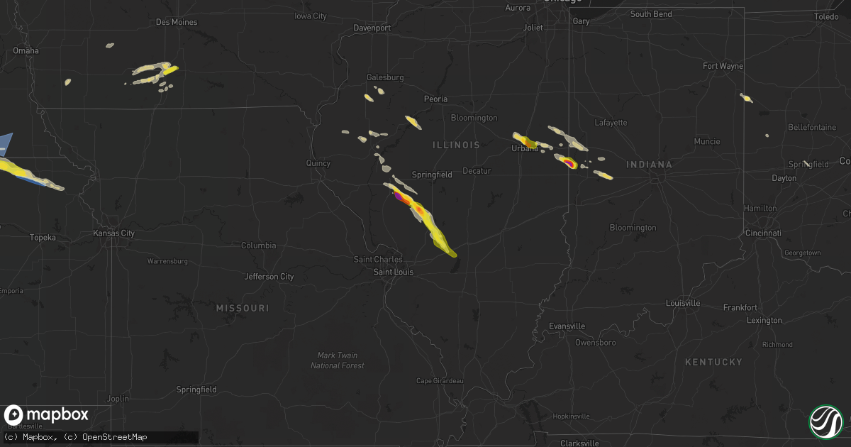
Hail Map on June 12, 2022
Get this storm
June 12 map
$229
one time, instant access
Download today. No call, no setup
Keep the $229
Bought the map and want the full workflow? Apply the entire $229 to a subscription within 7 days. None of it is wasted.
Every map, not just this one
This buys you this map. Subscription and you get every map we run, in the markets you choose from a few cities to whole states to nationwide. Plus real-time alerts the moment a storm fires.
Contact data
Name, contact info, occupancy, even credit band for addresses in the footprint. You go from where it hit to who to call.
Become the source they trust
Unlimited branding weather history reports on demand. You already have the documented answer ready for the property owner, and you are the one who showed up with it.
Property data and RoofTrace estimates
Pull up any address you have got, its value and the exact code rules for that jurisdiction, straight from One Click Code. Then RoofTrace estimates the squares, pitch, and roof value, priced the way you price.
States Impacted by Hail Map on June 12, 2022
Storm reports
Oklahoma
| Date | Description |
|---|---|
| 06/12/20227:13 AM CDT | At 1213 AM CDT, a severe thunderstorm was located 5 miles north of New Alluwe, moving southeast at 40 mph. HAZARD...60 mph wind gusts and quarter size hail. SOURCE...Radar indicated. IMPACT...Hail damage to vehicles is expected. Expect wind damage to roofs, siding, and trees. Locations in or near the path include... Chelsea... Big Cabin... New Alluwe... White Oak...This includes Interstate 44 between mile markers 264 and 281. |
Iowa
| Date | Description |
|---|---|
| 06/12/20227:09 AM CDT | At 1209 AM CDT, a severe thunderstorm was located over Donahue, or 8 miles northwest of Davenport, moving southeast at 40 mph. HAZARD...60 mph wind gusts and quarter size hail. SOURCE...Trained weather spotters. IMPACT...Hail damage to vehicles is expected. Expect wind damage to roofs, siding, and trees. This severe thunderstorm will be near... Davenport, Eldridge, Davenport Municipal Airport, Park View and Scott County Park around 1215 AM CDT. Mississippi Valley Fairgrounds around 1220 AM CDT. Rock Island, Bettendorf and Credit Island around 1225 AM CDT.Other locations in the path of this severe thunderstorm includeMoline, East Moline, Hampton, Riverdale, Panorama Park, CampbellsIsland, Rock Island Arsenal, Pleasant Valley, Illiniwek ForestPreserve, Fishermans Corner, Silvis, Rapids City, Carbon Cliff,Silvis Heights, Rock Island County Fairgrounds, Moline Quad-CityAirport, Indian Bluff Golf Course and Coal Valley. |
North Dakota
| Date | Description |
|---|---|
| 06/11/20228:59 PM CDT | At 159 PM CDT, a severe thunderstorm was located near Robbin, or 15 miles northeast of Grafton, moving east at 20 mph. HAZARD...60 mph wind gusts and quarter size hail. SOURCE...Radar indicated. IMPACT...Hail damage to vehicles is expected. Expect wind damage to roofs, siding, and trees. Locations impacted include... Donaldson and Stephen. |
Ohio
| Date | Description |
|---|---|
| 06/12/20226:27 PM CDT | Several reports of trees down in pike and german townships. Time estimated from radar. |
| 06/12/20224:05 PM CDT | A few trees were blown down along state route 56 near new plymouth. |
| 06/12/20224:02 PM CDT | Report of a tree down on state route 707 and now road. Time estimated from radar. |
| 06/12/20223:24 PM CDT | Tree down. |
| 06/12/20223:12 PM CDT | Trees down along sr 160 and sr 124 near wilkesville. |
| 06/12/20222:40 PM CDT | Several trees down along wolf hill rd. |
| 06/12/20222:05 AM CDT | At 704 PM EDT, a severe thunderstorm was located near St. Paris, moving southeast at 20 mph. HAZARD...60 mph wind gusts and quarter size hail. SOURCE...Radar indicated. IMPACT...Minor hail damage to vehicles is possible. Expect wind damage to trees and power lines. Locations impacted include... Springfield, Urbana, New Carlisle, St. Paris, Christiansburg, North Hampton, Fletcher, Tremont City, Casstown, Thackery, Westville, Haven View, Millerstown, Terre Haute, Lawrenceville, Dialton and Buck Creek State Park. |
| 06/11/202211:48 PM CDT | At 448 PM EDT, a severe thunderstorm was located near Hocking Hills State Park, or near Lake Hope State Park, moving southeast at 30 mph. HAZARD...60 mph wind gusts and quarter size hail. SOURCE...Radar indicated. IMPACT...Hail damage to vehicles is expected. Expect wind damage to roofs, siding, and trees. Locations impacted include... Athens, Albany, Lake Hope State Park, Zaleski, Creola and The Plains. |
| 06/11/202211:16 PM CDT | At 414 PM EDT, a severe thunderstorm was located 9 miles east of Wellston, moving southeast at 25 mph. THIS IS A DESTRUCTIVE STORM FOR WILKESVILLE and SALEM CENTER. HAZARD...80 mph wind gusts and golf ball size hail. SOURCE...Radar indicated. IMPACT...Flying debris will be dangerous to those caught without shelter. Mobile homes will be heavily damaged. Expect considerable damage to roofs, windows, and vehicles. Extensive tree damage and power outages are likely. Locations impacted include... Point Pleasant, Gallipolis, Pomeroy, Rio Grande, Rutland, New Haven, Mason, Middleport, Syracuse, Hartford City, Vinton, Wilkesville, Cheshire, Adamsville, Radcliffe, Lakin, Dyesville, Salem Center, Harrisonville and Dexter. |
| 06/11/202210:46 PM CDT | At 346 PM EDT, a severe thunderstorm was located near Mcarthur, moving southeast at 20 mph. HAZARD...60 mph wind gusts and quarter size hail. SOURCE...Radar indicated. IMPACT...Hail damage to vehicles is expected. Expect wind damage to roofs, siding, and trees. Locations impacted include... Wellston, Mcarthur, Hamden, Wilkesville, Dyesville, Salem Center, Radcliffe and Carpenter. |
| 06/11/202210:32 PM CDT | At 332 PM EDT, a severe thunderstorm was located over Mcarthur, moving southeast at 20 mph. HAZARD...60 mph wind gusts and quarter size hail. SOURCE...Radar indicated. IMPACT...Hail damage to vehicles is expected. Expect wind damage to roofs, siding, and trees. Locations impacted include... Wellston, Mcarthur, Hamden, Zaleski, Wilkesville, Dyesville, Allensville, Salem Center, Radcliffe and Carpenter. |
Idaho
| Date | Description |
|---|---|
| 06/12/20223:00 PM CDT | Large tree partially was uprooted and fell on house near east 2nd avenue in mountain home. Numerous small branches down with diameters of 1 to 2 inches. Porta potty blo |
| 06/11/20227:42 PM CDT | Mesonet station pcki1 pole creek. |
Nebraska
| Date | Description |
|---|---|
| 06/12/20226:14 PM CDT | Hail ended at 530 pm. |
| 06/12/20225:45 PM CDT | Wind damage to trees and a building on spring creek road in mitchell. Social media post. |
| 06/12/20225:31 PM CDT | Spotter estimated wind gusts of 50 to 60 mph. |
| 06/12/20225:17 PM CDT | A local report indicates 1.50 inch wind near 5 N MORRILL |
| 06/12/20227:39 AM CDT | At 1239 AM CDT, severe thunderstorms were located along a line extending from 13 miles southwest of Earling Hill to 7 miles northeast of Mosher to 2 miles south of Haystack Butte, moving east at 65 mph. HAZARD...70 mph wind gusts and quarter size hail. SOURCE...Radar indicated. IMPACT...Hail damage to vehicles is expected. Expect considerable tree damage. Wind damage is also likely to mobile homes, roofs, and outbuildings. Severe thunderstorms will be near... Witten around 1245 AM CDT. Ideal around 1250 AM CDT. Winner and Ideal South Housing around 1255 AM CDT.Other locations in the path of these severe thunderstorms includeKeyapaha, Hamill, Clearfield, Millboro, Dog Ear Lake and Wewela. |
| 06/12/20227:15 AM CDT | Mesonet report from earlier. |
| 06/12/20227:15 AM CDT | From a personal weather station. |
| 06/12/20227:10 AM CDT | Mesonet report from earlier. |
| 06/12/20226:54 AM CDT | At 1154 PM CDT, a severe thunderstorm was located near Portis, or 29 miles west of Beloit, moving east at 50 mph. HAZARD...60 mph wind gusts and half dollar size hail. SOURCE...Radar indicated. IMPACT...Hail damage to vehicles is expected. Expect wind damage to roofs, siding, and trees. This severe thunderstorm will be near... Ionia around 1210 AM CDT.Other locations in the path of this severe thunderstorm includeMankato, Jewell, Montrose, Formoso and Lovewell State Park. |
| 06/12/20226:40 AM CDT | At 1139 PM CDT, severe thunderstorms were located along a line extending from 6 miles north of Colome to near Wewela to Springview, moving east at 45 mph. HAZARD...60 mph wind gusts and quarter size hail. SOURCE...Radar indicated. IMPACT...Hail damage to vehicles is expected. Expect wind damage to roofs, siding, and trees. Severe thunderstorms will be near... Dallas around 1155 PM CDT.Other locations in the path of these severe thunderstorms includeGregory, Burke, Herrick, St. Charles, Bonesteel, Platte, Pickstownand Geddes. |
| 06/12/20226:35 AM CDT | At 1134 PM CDT, a severe thunderstorm was located 8 miles southeast of Norden, or 10 miles west of Springview, moving northeast at 45 mph. HAZARD...60 mph wind gusts and quarter size hail. SOURCE...Radar indicated. IMPACT...Hail damage to vehicles is expected. Expect wind damage to roofs, siding, and trees. Locations impacted include... Springview, Norden, Burton, Nets Peak, Thomas Creek State Wildlife Management Area, Bobcat State Wildlife Management Area, Mills, Meadville and North River Trail.This includes the following highways... Highway 183 between mile markers 207 and 225. Highway 12 between mile markers 27 and 78. |
| 06/12/20226:27 AM CDT | At 1127 PM CDT/1027 PM MDT/, a severe thunderstorm was located 8 miles southeast of Arthur, moving northeast at 40 mph. HAZARD...60 mph wind gusts and quarter size hail. SOURCE...Radar indicated. IMPACT...Hail damage to vehicles is expected. Expect wind damage to roofs, siding, and trees. Locations impacted include... Arthur, Bucktail Lake, Sand Beach Lake, Lena, Sand Puddin Lake, Three Mile Lake, Flatts, Big Lamunyon Flats, Bucktail, McKeag and Calora.This includes the following highways... Highway 61 between mile markers 112 and 127. Highway 92 between mile markers 165 and 186. |
| 06/12/20226:24 AM CDT | At 1124 PM CDT, severe thunderstorms were located along a line extending from 9 miles southeast of Franklin to Bellaire to Osborne, moving east at 55 mph. HAZARD...60 mph wind gusts and quarter size hail. SOURCE...Radar indicated. IMPACT...Hail damage to vehicles is expected. Expect wind damage to roofs, siding, and trees. Severe thunderstorms will be near... Lebanon around 1130 PM CDT. Downs around 1135 PM CDT. Cawker City and Esbon around 1140 PM CDT.Other locations in the path of these severe thunderstorms includeGlen Elder, Burr Oak, Mankato, Beloit, Guide Rock, Randall, Bostwickand Montrose. |
| 06/12/20225:56 AM CDT | At 1055 PM CDT, a severe thunderstorm was located 6 miles northwest of Keyapaha, or 22 miles southwest of Winner, moving northeast at 40 mph. HAZARD...60 mph wind gusts and quarter size hail. SOURCE...Radar indicated. IMPACT...Hail damage to vehicles is expected. Expect wind damage to roofs, siding, and trees. This severe thunderstorm will be near... Clearfield around 1105 PM CDT. Dog Ear Lake around 1115 PM CDT.Other locations in the path of this severe thunderstorm includeWinner, Colome and Ideal South Housing. |
| 06/12/20225:09 AM CDT | At 1008 PM MDT, a severe thunderstorm was located near Brule, or 11 miles southwest of Ogallala, moving northeast at 50 mph. HAZARD...60 mph wind gusts and quarter size hail. SOURCE...Radar indicated. IMPACT...Hail damage to vehicles is expected. Expect wind damage to roofs, siding, and trees. Locations impacted include... Ogallala, Paxton, Brule, Sarben, Lemoyne, Keystone, Roscoe, Kingsley Dam, Nevens, Broganville, Lake View Campground, Big Bald Hill and Wild Horse Spring.This includes the following highways... Highway 61 between mile markers 71 and 106. Highway 92 between mile markers 131 and 138. Interstate 80 in Nebraska between mile markers 112 and 149. |
| 06/12/20224:36 AM CDT | At 936 PM MDT, a severe thunderstorm was located near Venango, or 15 miles southeast of Julesburg, moving northeast at 45 mph. HAZARD...60 mph wind gusts and quarter size hail. SOURCE...Radar indicated. IMPACT...Hail damage to vehicles is expected. Expect wind damage to roofs, siding, and trees. Locations impacted include... Grant, Brule, Venango, Brandon and Wild Horse Spring. This includes the following highways... Highway 61 between mile markers 63 and 86. Interstate 80 in Nebraska between mile markers 114 and 125. |
| 06/12/20224:23 AM CDT | At 923 PM MDT, a severe thunderstorm was located near Sixteen-Mile Corner, or 11 miles north of Holyoke, moving northeast at 50 mph. HAZARD...60 mph wind gusts and quarter size hail. SOURCE...Radar indicated. IMPACT...Expect damage to roofs, siding, and trees. Hail damage to vehicles is expected. This severe thunderstorm will remain over mainly rural areas of northeastern Phillips and Sedgwick Counties. |
| 06/12/20222:35 AM CDT | At 734 PM MDT, severe thunderstorms were located along a line extending from 13 miles south of Gordon to 14 miles northeast of Antioch, moving east at 30 mph. HAZARD...70 mph wind gusts and ping pong ball size hail. SOURCE...Radar indicated. IMPACT...People and animals outdoors will be injured. Expect hail damage to roofs, siding, windows, and vehicles. Expect considerable tree damage. Wind damage is also likely to mobile homes, roofs, and outbuildings. Locations impacted include... Intersection of Highway 61 and Shadbolt Road, Diamond Lake, Big Hill, Billys Lake, Morgan Lake and Argo Hill.This includes the following highways... Highway 250 between mile markers 14 and 23. Highway 61 between mile markers 202 and 216. |
| 06/12/20222:31 AM CDT | At 731 PM MDT, a severe thunderstorm was located over Ellsworth, or 31 miles east of Alliance, moving northeast at 40 mph. HAZARD...60 mph wind gusts and quarter size hail. SOURCE...Radar indicated. IMPACT...Hail damage to vehicles is expected. Expect wind damage to roofs, siding, and trees. Locations impacted include... Ellsworth, Watson Lake, Bingham, Patterson Lake, Big Hill, Dipping Vat Meadow, Wolf Hill, Finnegan Lake, Kennedy Lake, Intersection of Highway 61 and Survey Valley Road and Mother Lake.This includes the following highways... Highway 2 between mile markers 112 and 133. Highway 61 between mile markers 176 and 183. |
| 06/12/20222:15 AM CDT | At 715 AM CDT, a severe thunderstorm was located near Bruning, or 33 miles north of Belleville, moving east at 35 mph. HAZARD...60 mph wind gusts and half dollar size hail. SOURCE...Radar indicated. IMPACT...Hail damage to vehicles is expected. Expect wind damage to roofs, siding, and trees. This severe thunderstorm will be near... Alexandria around 725 AM CDT. |
| 06/12/20221:59 AM CDT | At 659 PM MDT, a severe thunderstorm was located 7 miles northwest of Crescent Lake National Wildlife Refuge, or 27 miles southeast of Alliance, moving northeast at 35 mph. HAZARD...70 mph wind gusts and quarter size hail. SOURCE...Radar indicated. IMPACT...Hail damage to vehicles is expected. Expect considerable tree damage. Wind damage is also likely to mobile homes, roofs, and outbuildings. Locations impacted include... Crescent Lake National Wildlife Refuge, Mumper, Bingham, Finnegan Lake, Jerry Lake, Kincaid Lake and Wild Horse Flats.This includes Highway 2 between mile markers 120 and 132. |
| 06/12/20221:49 AM CDT | At 648 PM MDT, severe thunderstorms were located along a line extending from near Antioch to 11 miles southwest of Ellsworth to 6 miles east of The Intersection Of Highway 385 And 92, moving northeast at 35 mph. HAZARD...70 mph wind gusts and half dollar size hail. SOURCE...Radar indicated. IMPACT...Hail damage to vehicles is expected. Expect considerable tree damage. Wind damage is also likely to mobile homes, roofs, and outbuildings. Locations impacted include... Ellsworth, Antioch, Watson Lake, Patterson Lake, Kennedy Lake, Snow Lake, Richardson Lake, Miles Lake, Wickson Lake, Diamond Lake, Lakeside, Wolf Hill, Herman Lake, Krause Lake, Tralnor Lake and Argo Hill.This includes the following highways... Highway 250 between mile markers 1 and 20. Highway 2 between mile markers 96 and 120. |
| 06/12/20221:47 AM CDT | At 647 PM MDT, severe thunderstorms were located along a line extending from 12 miles south of Rushville to near Berea, moving northeast at 30 mph. HAZARD...Ping pong ball size hail and 60 mph wind gusts. SOURCE...Radar indicated. IMPACT...People and animals outdoors will be injured. Expect hail damage to roofs, siding, windows, and vehicles. Expect wind damage to roofs, siding, and trees. Locations impacted include... Lone Butte, Highway 27 crossing the Niobrara River, Smith Lake State Wildlife Management Area, Highway 250 crossing the Niobrara River, Walgren Lake State Recreation Area and Intersection of Highway 27 and Mills Road.This includes Highway 250 between mile markers 21 and 46. |
| 06/12/20221:33 AM CDT | At 633 AM CDT, a severe thunderstorm was located near Edgar, or 29 miles southeast of Hastings, moving east at 35 mph. HAZARD...60 mph wind gusts and half dollar size hail. SOURCE...Radar indicated. IMPACT...Hail damage to vehicles is expected. Expect wind damage to roofs, siding, and trees. This severe thunderstorm will be near... Davenport around 645 AM CDT. Shickley around 650 AM CDT.Other locations in the path of this severe thunderstorm includeCarleton, Strang, Bruning, Belvidere and Alexandria. |
| 06/12/20221:06 AM CDT | At 606 PM MDT, a severe thunderstorm was located near Northport, or 31 miles south of Alliance, moving northeast at 35 mph. HAZARD...60 mph wind gusts and quarter size hail. SOURCE...Radar indicated. IMPACT...Hail damage to vehicles is expected. Expect wind damage to roofs, siding, and trees. Locations impacted include... Bridgeport, Bridgeport State Recreation Area, Northport and The Intersection Of Highway 385 And 92. |
| 06/12/202212:44 AM CDT | At 544 AM CDT, a severe thunderstorm was located near Hansen, or near Hastings, moving east at 45 mph. HAZARD...Quarter size hail. SOURCE...Radar indicated. IMPACT...Damage to vehicles is expected. This severe thunderstorm will be near... Hastings and Hansen around 550 AM CDT. Trumbull around 555 AM CDT.Other locations in the path of this severe thunderstorm includeInland, Harvard, Clay Center, Saronville and Sutton. |
| 06/12/202212:15 AM CDT | Report received on social media. Time estimated based on time of report and radar. |
| 06/12/202212:15 AM CDT | Facebook... Time estimated from radar. |
| 06/12/202212:09 AM CDT | At 509 AM CDT, severe thunderstorms were located along a line extending from near Odessa to 8 miles northwest of Gibbon to near Shelton, moving east at 50 mph. HAZARD...Half dollar size hail. SOURCE...Radar indicated. IMPACT...Damage to vehicles is expected. Severe thunderstorms will be near... Shelton around 525 AM CDT.Other locations in the path of these severe thunderstorms includeGibbon, Wood River, Alda and Doniphan.This includes Interstate 80 between mile markers 266 and 317. |
| 06/12/202212:01 AM CDT | A local report indicates 58 MPH wind near 1 N NELSON |
| 06/11/202211:30 PM CDT | At 429 PM MDT, a severe thunderstorm was located over Stegall, or 15 miles southeast of Torrington, moving east at 20 mph. HAZARD...Ping pong ball size hail and 60 mph wind gusts. SOURCE...Radar indicated. IMPACT...People and animals outdoors will be injured. Expect hail damage to roofs, siding, windows, and vehicles. Expect wind damage to roofs, siding, and trees. Locations impacted include... Scottsbluff, Gering, Mitchell, Terrytown, Morrill, Lyman, Lake Minatare Campground, Stegall, Scotts Bluff National Monument, Hubbard Hill, Scottsbluff Airport, Lake Minatare, Lake Alice and Henry.This replaces the Severe Thunderstorm Warning which was previously in effect for the warned area. |
| 06/11/202211:08 PM CDT | At 407 PM MDT, a severe thunderstorm was located over Pine Bluffs, or 24 miles west of Kimball, moving east at 20 mph. HAZARD...Ping pong ball size hail and 60 mph wind gusts. SOURCE...Radar indicated. IMPACT...People and animals outdoors will be injured. Expect hail damage to roofs, siding, windows, and vehicles. Expect wind damage to roofs, siding, and trees. Locations impacted include... Pine Bluffs, Albin, Oliver Campground, Oliver Reservoir and Bushnell.This includes the following highways... Interstate 80 in Wyoming between mile markers 394 and 402. Interstate 80 in Nebraska between mile markers 1 and 13. |
| 06/11/20228:26 PM CDT | Estimated thunderstorm wind gust of 60 plus miles per hour |
| 06/11/20228:10 PM CDT | A local report indicates 60 MPH wind near 21 SE HAY SPRINGS |
| 06/11/20227:36 PM CDT | 63 knot gust from the southeast. |
Kansas
| Date | Description |
|---|---|
| 06/12/20226:55 PM CDT | Johnson city airport awos. |
| 06/12/20229:12 AM CDT | Mostly pea to half inch hail with a few around quarter size. |
| 06/12/20225:58 AM CDT | At 1058 PM CDT, severe thunderstorms were located along a line extending from near Woodston to 9 miles north of Natoma, moving northeast at 50 mph. HAZARD...60 mph wind gusts and quarter size hail. SOURCE...Radar indicated. IMPACT...Hail damage to vehicles is expected. Expect wind damage to roofs, siding, and trees. Severe thunderstorms will be near... Kirwin and Alton around 1110 PM CDT.Other locations in the path of these severe thunderstorms includeGaylord and Cedar. |
| 06/12/20225:27 AM CDT | At 1027 PM CDT, severe thunderstorms were located along a line extending from 9 miles north of Bogue to near Damar to 10 miles south of Zurich, moving northeast at 45 mph. HAZARD...60 mph wind gusts and quarter size hail. SOURCE...Radar indicated. IMPACT...Hail damage to vehicles is expected. Expect wind damage to roofs, siding, and trees. Severe thunderstorms will be near... Webster State Park around 1035 PM CDT. Plainville around 1040 PM CDT. Stockton, Logan and Codell around 1045 PM CDT.Other locations in the path of these severe thunderstorms includeWoodston, Speed, Phillipsburg, Kirwin and Glade. |
| 06/12/20225:23 AM CDT | At 1023 PM CDT, a severe thunderstorm was located 5 miles west of Palco, or 12 miles southeast of Hill City, moving northeast at 55 mph. HAZARD...60 mph wind gusts and quarter size hail. SOURCE...Radar indicated. IMPACT...Hail damage to vehicles is expected. Expect wind damage to roofs, siding, and trees. This severe thunderstorm will be near... Nicodemus around 1035 PM CDT. |
| 06/12/20225:03 AM CDT | At 1003 PM CDT, a severe thunderstorm was located near Ogallah, moving northeast at 50 mph. HAZARD...60 mph wind gusts and quarter size hail. SOURCE...Radar indicated. IMPACT...Hail damage to vehicles is expected. Expect wind damage to roofs, siding, and trees. This severe thunderstorm will be near... Palco around 1020 PM CDT.Other locations in the path of this severe thunderstorm include Damarand Zurich. |
| 06/12/20224:46 AM CDT | At 945 PM CDT, a severe thunderstorm was located 11 miles west of Trego Center, moving northeast at 55 mph. HAZARD...60 mph wind gusts and quarter size hail. SOURCE...Radar indicated. IMPACT...Hail damage to vehicles is expected. Expect wind damage to roofs, siding, and trees. This severe thunderstorm will remain over mainly rural areas of southeastern Sheridan, northeastern Gove and Graham Counties, including the following locations... Saint Peter, Studley and Penokee.This includes Interstate 70 in Kansas between mile markers 95 and112. |
| 06/12/20224:42 AM CDT | At 941 PM CDT, severe thunderstorms were located along a line extending from near Park to near Brownell, moving northeast at 25 mph. HAZARD...60 mph wind gusts and penny size hail. SOURCE...Radar indicated. IMPACT...Expect damage to roofs, siding, and trees. Severe thunderstorms will be near... Brownell around 955 PM CDT.Other locations in the path of these severe thunderstorms includeCedar Bluff. |
| 06/12/20224:36 AM CDT | At 935 AM CDT, a severe thunderstorm was located over Kickapoo Reservation, or near Horton, moving east at 45 mph. HAZARD...60 mph wind gusts and quarter size hail. SOURCE...Radar indicated. IMPACT...Hail damage to vehicles is expected. Expect wind damage to roofs, siding, and trees. Locations impacted include... Atchison, Effingham, Lancaster, Muscotah, Denton, Farmington, Huron and Arrington. |
| 06/12/20224:30 AM CDT | At 930 AM CDT, a severe thunderstorm was located 5 miles northwest of Kickapoo Reservation, moving southeast at 50 mph. HAZARD...60 mph wind gusts and quarter size hail. SOURCE...Radar indicated. IMPACT...Hail damage to vehicles is expected. Expect wind damage to roofs, siding, and trees. Locations impacted include... Hiawatha, Horton, Everest, Robinson, Whiting, Netawaka, Powhattan, Willis and Kickapoo Reservation. |
| 06/12/20224:29 AM CDT | At 928 PM CDT, severe thunderstorms were located along a line extending from 11 miles north of Pendennis to 7 miles west of Ness City, moving northeast at 20 mph. HAZARD...60 mph wind gusts and nickel size hail. SOURCE...Radar indicated. IMPACT...Expect damage to roofs, siding, and trees. These severe thunderstorms will remain over mainly rural areas of northwestern Ness, southwestern Trego and northeastern Lane Counties. |
| 06/12/20224:17 AM CDT | At 916 PM CDT, a severe thunderstorm was located 7 miles north of Healy, moving northeast at 40 mph. HAZARD...60 mph wind gusts and quarter size hail. SOURCE...Radar indicated. IMPACT...Hail damage to vehicles is expected. Expect wind damage to roofs, siding, and trees. This severe thunderstorm will remain over mainly rural areas of Gove County.This includes Interstate 70 in Kansas between mile markers 94 and 98. |
| 06/12/20224:10 AM CDT | At 910 AM CDT, a severe thunderstorm was located near Seneca, moving east at 40 mph. HAZARD...60 mph wind gusts and quarter size hail. SOURCE...Radar indicated. IMPACT...Hail damage to vehicles is expected. Expect wind damage to roofs, siding, and trees. Locations impacted include... Hiawatha, Sabetha, Seneca, Fairview, Morrill, Bern, Powhattan, Oneida, Hamlin, Kickapoo Reservation and Woodlawn. |
| 06/12/20223:49 AM CDT | At 849 PM CDT, severe thunderstorms were located along a line extending from near Scott State Lake to 15 miles northwest of Kalvesta, moving northeast at 25 mph. HAZARD...70 mph wind gusts and half dollar size hail. SOURCE...Radar indicated. IMPACT...Hail damage to vehicles is expected. Expect considerable tree damage. Wind damage is also likely to mobile homes, roofs, and outbuildings. Locations impacted include... Alamota and Beeler. |
| 06/12/20223:44 AM CDT | At 844 PM CDT, a severe thunderstorm was located 8 miles west of Scott State Lake, moving northeast at 30 mph. HAZARD...60 mph wind gusts and quarter size hail. SOURCE...Radar indicated. IMPACT...Hail damage to vehicles is expected. Expect wind damage to roofs, siding, and trees. This severe thunderstorm will remain over mainly rural areas of northeastern Wichita, southeastern Logan and southwestern Gove Counties, including the following locations... The Monument Rocks. |
| 06/12/20223:40 AM CDT | At 840 AM CDT, a severe thunderstorm was located 4 miles south of Summerfield, moving east at 45 mph. HAZARD...60 mph wind gusts and penny size hail. SOURCE...Radar indicated. IMPACT...Expect damage to roofs, siding, and trees. Locations impacted include... Seneca, Axtell, Beattie, Bern, Summerfield and Baileyville. |
| 06/12/20223:36 AM CDT | At 836 PM CDT, severe thunderstorms were located along a line extending from 15 miles northwest of Kalvesta to near Howell, moving northeast at 20 mph. HAZARD...60 mph wind gusts and quarter size hail. SOURCE...Radar indicated. IMPACT...Hail damage to vehicles is expected. Expect wind damage to roofs, siding, and trees. These severe thunderstorms will remain over mainly rural areas of northwestern Ford, northeastern Finney, southwestern Ness, western Hodgeman, southeastern Lane and northeastern Gray Counties. |
| 06/12/20223:26 AM CDT | At 826 PM CDT, severe thunderstorms were located along a line extending from 6 miles west of Modoc to 6 miles northeast of Garden City, moving northeast at 30 mph. HAZARD...70 mph wind gusts and half dollar size hail. SOURCE...Radar indicated. IMPACT...Hail damage to vehicles is expected. Expect considerable tree damage. Wind damage is also likely to mobile homes, roofs, and outbuildings. Severe thunderstorms will be near... Modoc around 835 PM CDT.Other locations in the path of these severe thunderstorms includeScott State Lake. |
| 06/12/20223:18 AM CDT | At 818 PM CDT, a severe thunderstorm was located over Leoti, moving northeast at 50 mph. HAZARD...60 mph wind gusts and quarter size hail. SOURCE...Radar indicated. IMPACT...Hail damage to vehicles is expected. Expect wind damage to roofs, siding, and trees. This severe thunderstorm will remain over mainly rural areas of Wichita and southwestern Logan Counties, including the following locations... Marienthal and Selkirk. |
| 06/12/20223:12 AM CDT | At 812 AM CDT, a severe thunderstorm was located near Wymore, moving east at 45 mph. HAZARD...60 mph wind gusts and quarter size hail. SOURCE...Radar indicated. IMPACT...Hail damage to vehicles is expected. Expect wind damage to roofs, siding, and trees. Locations impacted include... Summerfield and Oketo. |
| 06/12/20223:06 AM CDT | At 806 PM CDT, severe thunderstorms were located along a line extending from near Garden City to near Montezuma, moving northeast at 25 mph. HAZARD...60 mph wind gusts and penny size hail. SOURCE...Radar indicated. IMPACT...Expect damage to roofs, siding, and trees. These severe thunderstorms will remain over mainly rural areas of central Finney, Gray and northeastern Haskell Counties. |
| 06/12/20222:55 AM CDT | At 755 AM CDT, a severe thunderstorm was located 3 miles east of Diller, or 13 miles southwest of Beatrice, moving east at 40 mph. HAZARD...60 mph wind gusts and nickel size hail. SOURCE...Emergency management. IMPACT...Expect damage to roofs, siding, and trees. Locations impacted include... Beatrice, Pawnee City, Wymore, Blue Springs, Odell, Table Rock, Diller, Pickrell, Summerfield, Du Bois, Filley, Barneston, Burchard, Liberty, Lewiston, Steele City, Virginia, Holmesville, Steinauer and Homestead National Historical Park. |
| 06/12/20222:42 AM CDT | At 741 PM CDT/641 PM MDT/, a severe thunderstorm was located 7 miles northeast of Kendall, moving northeast at 30 mph. HAZARD...70 mph wind gusts and nickel size hail. SOURCE...Radar indicated. IMPACT...Expect considerable tree damage. Damage is likely to mobile homes, roofs, and outbuildings. Locations impacted include... Lakin and Deerfield. |
| 06/12/20222:38 AM CDT | At 737 PM CDT, a severe thunderstorm was located near Sublette, moving east at 30 mph. HAZARD...70 mph wind gusts and nickel size hail. SOURCE...Radar indicated. IMPACT...Expect considerable tree damage. Damage is likely to mobile homes, roofs, and outbuildings. This severe thunderstorm will be near... Tice around 750 PM CDT.Other locations in the path of this severe thunderstorm includeCopeland and Montezuma. |
| 06/12/20222:10 AM CDT | At 710 AM CDT, a severe thunderstorm was located near Belvidere, or 19 miles northwest of Fairbury, moving east at 40 mph. HAZARD...60 mph wind gusts and quarter size hail. SOURCE...Radar indicated. IMPACT...Hail damage to vehicles is expected. Expect wind damage to roofs, siding, and trees. This severe thunderstorm will be near... Daykin around 720 AM CDT.Other locations in the path of this severe thunderstorm includeFairbury, Endicott, Jansen, Steele City, Harbine, Diller and Odell. |
| 06/12/20222:03 AM CDT | At 702 PM CDT, a severe thunderstorm was located near Big Bow, moving east at 60 mph. HAZARD...70 mph wind gusts. Areas of blowing dust are likely. SOURCE...Automated equipment. The Johnson Airport measured a gust of 70 mph at 655 pm CDT. IMPACT...Expect considerable tree damage. Damage is likely to mobile homes, roofs, and outbuildings. This severe thunderstorm will be near... Hickok around 715 PM CDT. |
| 06/12/20221:56 AM CDT | At 656 PM CDT/556 PM MDT/, a severe thunderstorm was located near Syracuse, moving northeast at 35 mph. HAZARD...70 mph wind gusts and quarter size hail. Areas of blowing dust are likely. SOURCE...Radar indicated. IMPACT...Hail damage to vehicles is expected. Expect considerable tree damage. Wind damage is also likely to mobile homes, roofs, and outbuildings. This severe thunderstorm will be near... Syracuse around 605 PM MDT.Other locations in the path of this severe thunderstorm includeKendall. |
| 06/12/20221:08 AM CDT | At 607 PM CDT/507 PM MDT/, severe thunderstorms were located along a line extending from near Holly to 11 miles northwest of The Saunders Elevator, moving east at 35 mph. HAZARD...60 mph wind gusts. SOURCE...Radar indicated. IMPACT...Expect damage to roofs, siding, and trees. Severe thunderstorms will be near... Coolidge around 520 PM MDT.Other locations in the path of these severe thunderstorms includeManter, Johnson City and Syracuse. |
| 06/12/202212:01 AM CDT | Power pole caught on fire from arcing power lines. |
| 06/11/202211:32 PM CDT | Report via facebook. Time est from radar. |
| 06/11/202211:32 PM CDT | Report received via facebook of quarter size hail on the northeast side of lebanon. |
| 06/11/202211:30 PM CDT | Two to eight inch diameter tree branches down. Additionally... Observer reported dime sized hail with the storm. |
| 06/11/202211:30 PM CDT | Received report and photos via facebook of roof damage to a grocery store in lebanon. Also included was a report of tree damage and some livestock shed damage at a farm |
| 06/11/202211:27 PM CDT | Report via facebook. Time est from radar. |
| 06/11/202211:23 PM CDT | At 423 PM MDT, a severe thunderstorm was located 16 miles northeast of Two Buttes Reservoir, or 20 miles southeast of Lamar, moving northeast at 25 mph. HAZARD...60 mph wind gusts and penny size hail. SOURCE...Radar indicated. IMPACT...Expect damage to roofs, siding, and trees. Locations impacted include... Holly, Granada, Hartman and Bristol. |
| 06/11/20229:40 PM CDT | A local report indicates 58 MPH wind near 3 ENE GOVE |
| 06/11/20229:24 PM CDT | Corrects previous tstm wnd gst report from 9 nnw the monument rocks. Delayed report... Report on social media of measured 63 mph gust east of russel springs and south o |
| 06/11/20229:17 PM CDT | Delayed report... Report on social media of measured 63 mph gust east of russel springs and south of oakley. Video with post showed near zero visibility in blowing dust |
| 06/11/20229:10 PM CDT | Kansas mesonet. Wind gust of 50 mph at 2m elevation... 59 mph at 10m elevation. |
| 06/11/20228:32 PM CDT | Truck and camper blown over just south of the scott finney county line. Relayed by scott county sheriffs office. |
| 06/11/20228:30 PM CDT | Truck blown off road east of ingalls... Reported by public on social media |
| 06/11/20227:15 PM CDT | A local report indicates 70 MPH wind near SYRACUSE |
South Dakota
| Date | Description |
|---|---|
| 06/12/20226:56 PM CDT | A local report indicates 1.75 inch wind near 3 NE WHITEWOOD |
| 06/12/20226:26 PM CDT | Also measured 70 mph wind gust. Large branches are down. |
| 06/12/20226:15 PM CDT | Wind gust measured via unl mobile mesonet in rfd |
| 06/12/20226:00 PM CDT | Large tree uprooted |
| 06/12/20226:00 PM CDT | Wind driven baseball to softball size hail. Winds estimated over 75 mph. |
| 06/12/20225:59 PM CDT | Report from belle fourche fire chief. Reports that hail is also getting bigger. |
| 06/12/20227:45 AM CDT | At 1245 AM CDT, severe thunderstorms were located along a line extending from 5 Mile Corner to near Earling Hill to 10 miles northwest of Ideal, moving east at 55 mph. HAZARD...60 mph wind gusts. SOURCE...Radar indicated. IMPACT...Expect damage to roofs, siding, and trees. Locations impacted include... Iona, Lake Francis Case, Oacoma and Dude Ranch. |
| 06/12/20226:53 AM CDT | At 1152 PM CDT, severe thunderstorms were located along a line extending from near Lower Brule to Reliance to near Hamill, moving east at 40 mph. HAZARD...70 mph wind gusts and ping pong ball size hail. SOURCE...Radar indicated. IMPACT...People and animals outdoors will be injured. Expect hail damage to roofs, siding, windows, and vehicles. Expect considerable tree damage. Wind damage is also likely to mobile homes, roofs, and outbuildings. Severe thunderstorms will be near... Lake Francis Case around 1200 AM CDT. Chamberlain around 1210 AM CDT.Other locations in the path of these severe thunderstorms includeKimball and Grass Ranch Colony. |
| 06/12/20226:50 AM CDT | At 1150 PM CDT, severe thunderstorms were located along a line extending from 7 miles east of Grey Goose to 11 miles north of 5 Mile Corner, moving east at 40 mph. HAZARD...60 mph wind gusts and penny size hail. SOURCE...Trained weather spotters. IMPACT...Expect damage to roofs, siding, and trees. Severe thunderstorms will be near... Canning around 1200 AM CDT. Blunt around 1205 AM CDT. Cedar Creek Rec Area around 1210 AM CDT.Other locations in the path of these severe thunderstorms include JoeCreek Rec Area, Harrold, West Bend Rec Area, Lower Brule andHolabird. |
| 06/12/20226:45 AM CDT | At 1144 PM CDT, severe thunderstorms were located along a line extending from near West Bend Rec Area to near Hamill, moving east at 50 mph. HAZARD...Two inch hail and 70 mph wind gusts. SOURCE...Radar indicated. IMPACT...People and animals outdoors will be injured. Expect hail damage to roofs, siding, windows, and vehicles. Expect considerable tree damage. Wind damage is also likely to mobile homes, roofs, and outbuildings. Locations impacted include... Iona and Pleasant Valley Country Church. |
| 06/12/20226:15 AM CDT | At 1114 PM CDT, a severe thunderstorm was located 11 miles north of Mosher, or 21 miles southwest of Presho, moving east at 40 mph. HAZARD...70 mph wind gusts and ping pong ball size hail. SOURCE...Radar indicated. IMPACT...People and animals outdoors will be injured. Expect hail damage to roofs, siding, windows, and vehicles. Expect considerable tree damage. Wind damage is also likely to mobile homes, roofs, and outbuildings. Locations impacted include... Ideal and Hamill. |
| 06/12/20226:03 AM CDT | At 1103 PM MDT, severe thunderstorms were located along a line extending from near Hoover to 3 miles southwest of Newell Lake, moving east at 55 mph. HAZARD...70 mph wind gusts. SOURCE...Radar indicated. IMPACT...Expect considerable tree damage. Damage is likely to mobile homes, roofs, and outbuildings. Severe thunderstorms will be near... Dears Ears Butte around 1110 PM MDT.Other locations in the path of these severe thunderstorms include MudButte, Maurine, Opal, Faith and Durkee Lake. |
| 06/12/20225:52 AM CDT | At 1052 PM CDT/952 PM MDT/, severe thunderstorms were located along a line extending from 12 miles south of Pierre to Mosher, moving east at 40 mph. THESE ARE DESTRUCTIVE STORMS. HAZARD...80 mph wind gusts and tennis ball size hail. SOURCE...Radar indicated. IMPACT...Flying debris will be dangerous to those caught without shelter. Mobile homes will be heavily damaged. Expect considerable damage to roofs, windows, and vehicles. Extensive tree damage and power outages are likely. Severe thunderstorms will be near... Rousseau around 1110 PM CDT.Other locations in the path of these severe thunderstorms includeCedar Creek Rec Area, Degrey Rec Area, Joe Creek Rec Area and WestBend Rec Area. |
| 06/12/20225:38 AM CDT | At 1038 PM MDT, severe thunderstorms were located along a line extending from 6 miles east of Ludlow to 9 miles east of Buffalo to 4 miles southwest of East Short Pines to 4 miles northwest of Antelope Butte, moving east at 65 mph. HAZARD...60 mph wind gusts and quarter size hail. SOURCE...Radar indicated. IMPACT...Hail damage to vehicles is expected. Expect wind damage to roofs, siding, and trees. Severe thunderstorms will be near... Ralph around 1045 PM MDT. Reva and Slim Buttes around 1050 PM MDT. Sorum and Haystack Buttes around 1055 PM MDT.Other locations in the path of these severe thunderstorms includePrairie City, Lodgepole, Hoover, Sheep Buttes, Bison, Zeona,Shadehill Reservoir and Owen Lake. |
| 06/12/20225:26 AM CDT | At 1024 PM CDT, a severe thunderstorm was located over Murdo, moving southeast at 40 mph. THIS IS A DESTRUCTIVE STORM FOR JONES COUNTY. HAZARD...80 mph wind gusts and baseball size hail. SOURCE...Trained weather spotters. At 1015pm, semis were blown over on I90 at 12 miles and 20 miles west of Murdo. IMPACT...Flying debris will be dangerous to those caught without shelter. Mobile homes will be heavily damaged. Expect considerable damage to roofs, windows, and vehicles. Extensive tree damage and power outages are likely. This severe thunderstorm will be near... Draper and Westover around 1035 PM CDT. |
| 06/12/20224:28 AM CDT | At 927 PM CDT/827 PM MDT/, a severe thunderstorm was located near Midland, or 22 miles east of Philip, moving east at 40 mph. HAZARD...Two inch hail and 70 mph wind gusts. SOURCE...Radar indicated. IMPACT...People and animals outdoors will be injured. Expect hail damage to roofs, siding, windows, and vehicles. Expect considerable tree damage. Wind damage is also likely to mobile homes, roofs, and outbuildings. This severe thunderstorm will be near... Capa around 945 PM CDT.Other locations in the path of this severe thunderstorm include Murdoand Draper. |
| 06/12/20224:15 AM CDT | At 914 PM MDT/1014 PM CDT/, a severe thunderstorm was located 9 miles west of Intersection of Highway 83 and White River, or 11 miles northwest of White River, moving east at 40 mph. HAZARD...Tennis ball size hail and 70 mph wind gusts. SOURCE...Radar indicated. IMPACT...People and animals outdoors will be injured. Expect hail damage to roofs, siding, windows, and vehicles. Expect considerable tree damage. Wind damage is also likely to mobile homes, roofs, and outbuildings. This severe thunderstorm will remain over mainly rural areas of central Mellette and eastern Jackson Counties, north of White River.This includes Interstate 90 in South Dakota between Mile Markers 172and 174. |
| 06/12/20224:10 AM CDT | At 909 PM CDT/809 PM MDT/, severe thunderstorms were located along a line extending from 9 miles southwest of Merriman to 8 miles northeast of Ashby, moving northeast at 40 mph. HAZARD...60 mph wind gusts and quarter size hail. SOURCE...Radar indicated. IMPACT...Hail damage to vehicles is expected. Expect wind damage to roofs, siding, and trees. Locations impacted include... Cody, Kilgore, Nenzel, Medicine Lake, Speckel Meir Lake, Eli, Steer Creek Campground, Mother Lake, Cody Lake, Marsh Flat, Round Lake, Hire, and Indian Hill.This includes the following highways... Highway 20 between mile markers 139 and 178. Highway 61 between mile markers 166 and 224. Highway 97 between mile markers 82 and 101. |
| 06/12/20223:14 AM CDT | At 814 PM MDT, a severe thunderstorm was located 4 miles southeast of Elm Springs, or 41 miles east of Rapid City, moving east at 35 mph. HAZARD...60 mph wind gusts and half dollar size hail. SOURCE...Radar indicated. IMPACT...Hail damage to vehicles is expected. Expect wind damage to roofs, siding, and trees. Locations impacted include... Creighton. |
| 06/12/20223:11 AM CDT | At 810 PM MDT/910 PM CDT/, severe thunderstorms were located along a line extending from 4 miles northeast of Ottumwa to 2 miles south of Nowlin to 7 miles southeast of Cactus Flat, moving southeast at 45 mph. HAZARD...Two inch hail and 60 mph wind gusts. SOURCE...Radar indicated. IMPACT...People and animals outdoors will be injured. Expect hail damage to roofs, siding, windows, and vehicles. Expect wind damage to roofs, siding, and trees. Severe thunderstorms will be near... Midland and Nowlin around 815 PM MDT. Intersection of Highway 73 and White River around 825 PM MDT.Other locations in the path of these severe thunderstorms includeNorris, Corn Creek, Black Pipe and Cedar Butte.This includes Interstate 90 in South Dakota between Mile Markers 113and 174. |
| 06/12/20222:31 AM CDT | Mesonet station 209 lowry |
| 06/12/20222:26 AM CDT | A local report indicates 58 MPH wind near 4 S ARLINGTON |
| 06/12/20222:17 AM CDT | At 716 PM MDT, severe thunderstorms were located along a line extending from 8 miles west of Union Center to 3 miles west of Nemo, moving east at 35 mph. HAZARD...Ping pong ball size hail and 60 mph wind gusts. SOURCE...Radar indicated. IMPACT...People and animals outdoors will be injured. Expect hail damage to roofs, siding, windows, and vehicles. Expect wind damage to roofs, siding, and trees. Severe thunderstorms will be near... Union Center and Tilford around 730 PM MDT. Black Hawk around 735 PM MDT.Other locations in the path of these severe thunderstorms includeEnning, White Owl, Ellsworth Air Force Base, northern Box Elder,Plainview, Viewfield and Curlew Lake.This includes Interstate 90 in South Dakota between Mile Markers 39and 53. |
| 06/12/20222:14 AM CDT | At 714 PM MDT, a severe thunderstorm was located 4 miles northwest of Grindstone, or 20 miles northwest of Philip, moving southeast at 40 mph. HAZARD...Two inch hail and 60 mph wind gusts. SOURCE...Radar indicated. IMPACT...People and animals outdoors will be injured. Expect hail damage to roofs, siding, windows, and vehicles. Expect wind damage to roofs, siding, and trees. This severe thunderstorm will be near... Grindstone Butte around 730 PM MDT.Other locations in the path of this severe thunderstorm includePhilip and Nowlin.This includes Interstate 90 in South Dakota between Mile Markers 87and 126, and between Mile Markers 136 and 160. |
| 06/12/20222:02 AM CDT | Mesonet station 178 trail city |
| 06/12/20221:58 AM CDT | At 657 PM MDT, a severe thunderstorm was located near Curlew Lake, or 24 miles northeast of Rapid City, moving east at 30 mph. HAZARD...Golf ball size hail and 60 mph wind gusts. SOURCE...Radar indicated. IMPACT...People and animals outdoors will be injured. Expect hail damage to roofs, siding, windows, and vehicles. Expect wind damage to roofs, siding, and trees. This severe thunderstorm will remain over mainly rural areas of south central Meade and east central Pennington Counties. |
| 06/12/20221:37 AM CDT | Mesonet station 205 mclaughlin |
| 06/12/20221:35 AM CDT | At 635 PM MDT, a severe thunderstorm was located 3 miles southwest of Elm Springs, or 35 miles northeast of Rapid City, moving east at 10 mph. HAZARD...Golf ball size hail and 60 mph wind gusts. SOURCE...Radar indicated. IMPACT...People and animals outdoors will be injured. Expect hail damage to roofs, siding, windows, and vehicles. Expect wind damage to roofs, siding, and trees. This severe thunderstorm will remain over mainly rural areas of southeastern Meade and northeastern Pennington Counties. |
| 06/12/20221:29 AM CDT | A local report indicates 58 MPH wind near 4 SSE MITCHELL |
| 06/12/20221:23 AM CDT | At 623 PM MDT, a severe thunderstorm was located over Apple Springs, or 5 miles west of Sturgis, moving east at 45 mph. HAZARD...Golf ball size hail and 70 mph wind gusts. SOURCE...Radar indicated. IMPACT...People and animals outdoors will be injured. Expect hail damage to roofs, siding, windows, and vehicles. Expect considerable tree damage. Wind damage is also likely to mobile homes, roofs, and outbuildings. This severe thunderstorm will be near... Sturgis and Fort Meade around 630 PM MDT. Bear Butte State Park around 635 PM MDT.This includes Interstate 90 in South Dakota between Mile Markers 14and 41. |
| 06/12/20221:21 AM CDT | Gas station canopy damaged. Time estimated from radar. |
| 06/12/20221:20 AM CDT | A local report indicates 75 MPH wind near LANE |
| 06/12/20221:15 AM CDT | A local report indicates 64 MPH wind near LANE |
| 06/12/20221:15 AM CDT | A local report indicates 65 MPH wind near 6 E MOUNT VERNON |
| 06/12/20221:11 AM CDT | At 610 PM MDT, a severe thunderstorm was located 8 miles north of Hereford, or 31 miles east of Sturgis, moving east at 40 mph. THIS IS A DESTRUCTIVE STORM FOR UNION CENTER AND AREAS NORTH OF HEREFORD. HAZARD...Baseball size hail and 70 mph wind gusts. SOURCE...Radar indicated. IMPACT...People and animals outdoors will be severely injured. Expect shattered windows, extensive damage to roofs, siding, and vehicles. This severe thunderstorm will be near... Union Center around 625 PM MDT. Enning around 630 PM MDT. |
| 06/12/20221:04 AM CDT | A local report indicates 77 MPH wind near 1 NNE FAITH |
| 06/12/202212:59 AM CDT | Personal weather station. |
| 06/12/202212:54 AM CDT | Metal roof panels blown off pole barn. Time estimated from radar. |
| 06/12/202212:50 AM CDT | At 550 PM MDT, a severe thunderstorm was located near Whitewood, or 5 miles northwest of Sturgis, moving east at 35 mph. HAZARD...Ping pong ball size hail and 60 mph wind gusts. SOURCE...Radar indicated. IMPACT...People and animals outdoors will be injured. Expect hail damage to roofs, siding, windows, and vehicles. Expect wind damage to roofs, siding, and trees. This severe thunderstorm will be near... Sturgis and Fort Meade around 555 PM MDT. Bear Butte State Park around 600 PM MDT.This includes Interstate 90 in South Dakota between Mile Markers 21and 35. |
| 06/12/202212:50 AM CDT | Tree branches 1.5 inches in diameter broken off. |
| 06/12/202212:47 AM CDT | At 546 PM MDT, a severe thunderstorm was located 6 miles north of Moskee, or 8 miles east of Sundance, moving east at 40 mph. HAZARD...Golf ball size hail and 70 mph wind gusts. SOURCE...Radar indicated. IMPACT...People and animals outdoors will be injured. Expect hail damage to roofs, siding, windows, and vehicles. Expect considerable tree damage. Wind damage is also likely to mobile homes, roofs, and outbuildings. This severe thunderstorm will be near... Moskee around 550 PM MDT. Cement Ridge Lookout around 555 PM MDT. Roughlock Falls and Iron Creek Lake around 605 PM MDT.Other locations in the path of this severe thunderstorm includeSavoy, O'Neil Pass, Cheyenne Crossing, Terry Peak, Lead, Deadwood,Central City, Brownsville, Galena and Roubaix Lake.This includes Interstate 90 in Wyoming between Mile Markers 180 and203. |
| 06/12/202212:11 AM CDT | A local report indicates 69 MPH wind near 14 W PLATTE |
| 06/12/202212:10 AM CDT | At 509 PM MDT, a severe thunderstorm was located near Fruitdale, or 7 miles east of Belle Fourche, moving east at 50 mph. THIS IS A DESTRUCTIVE STORM FOR FRUITDALE, NISLAND, AND VALE. HAZARD...Softball size hail and 70 mph wind gusts. SOURCE...Radar indicated. IMPACT...People and animals outdoors will be severely injured. Expect shattered windows, extensive damage to roofs, siding, and vehicles. This severe thunderstorm will be near... Nisland around 520 PM MDT. Newell around 525 PM MDT.Other locations in the path of this severe thunderstorm include Vale. |
| 06/12/202212:09 AM CDT | Personal weather station. |
| 06/12/202212:07 AM CDT | Asos station kpir pierre muni ap. |
| 06/12/202212:06 AM CDT | A local report indicates 59 MPH wind near DIXON |
| 06/12/202212:05 AM CDT | A local report indicates 64 MPH wind near 2 W OACOMA |
| 06/12/202212:01 AM CDT | Mesonet station 212 sd rwis agar. |
| 06/11/202211:59 PM CDT | Mesonet station 54 reliance |
| 06/11/202211:58 PM CDT | A local report indicates 59 MPH wind near 7 WSW HOOVER |
| 06/11/202211:56 PM CDT | Report from mping: 1-inch tree limbs broken; shingles blown off. |
| 06/11/202211:50 PM CDT | A local report indicates 73 MPH wind near 12 WSW CASTLE ROCK |
| 06/11/202211:45 PM CDT | A local report indicates 70 MPH wind near 10 W REVA |
| 06/11/202211:41 PM CDT | A local report indicates 84 MPH wind near 8 N REDIG |
| 06/11/202211:30 PM CDT | A local report indicates 1.50 inch wind near 16 N WITTEN |
| 06/11/202211:28 PM CDT | A local report indicates 77 MPH wind near 1 N BUFFALO |
| 06/11/202211:00 PM CDT | Small/large tree branches down. |
| 06/11/202210:30 PM CDT | Extensive wind damage to their area. |
| 06/11/202210:20 PM CDT | Semi tractor trailer blown over on interstate 90. |
| 06/11/202210:15 PM CDT | Semi tractor trailer blown over on interstate 90. |
| 06/11/202210:10 PM CDT | At 310 AM CDT, a severe thunderstorm was located near Westover, or 7 miles southwest of Murdo, moving east at 55 mph. HAZARD...60 mph wind gusts and quarter size hail. SOURCE...Radar indicated. IMPACT...Hail damage to vehicles is expected. Expect wind damage to roofs, siding, and trees. This severe thunderstorm will be near... Westover and Intersection of Highway 83 and White River around 315 AM CDT. |
| 06/11/20229:50 PM CDT | A local report indicates 60 MPH wind near 10 NNE QUINN |
| 06/11/20229:44 PM CDT | At 243 AM CDT, a severe thunderstorm was located 7 miles northwest of Keyapaha, or 22 miles southeast of Mission, moving east at 70 mph. HAZARD...70 mph wind gusts and half dollar size hail. SOURCE...Radar indicated. IMPACT...Hail damage to vehicles is expected. Expect considerable tree damage. Wind damage is also likely to mobile homes, roofs, and outbuildings. This severe thunderstorm will be near... Millboro and Clearfield around 255 AM CDT. Dog Ear Lake around 300 AM CDT.Other locations in the path of this severe thunderstorm includeWewela. |
| 06/11/20229:20 PM CDT | A local report indicates 67 MPH wind near 2 E COTTONWOOD |
| 06/11/20229:16 PM CDT | A local report indicates 61 MPH wind near 4 E CACTUS FLAT |
| 06/11/20229:03 PM CDT | A local report indicates 1.75 inch wind near 6 SSW ELM SPRINGS |
| 06/11/20228:58 PM CDT | At 158 AM CDT, a severe thunderstorm was located over Black Pipe, or 24 miles west of White River, moving east at 55 mph. HAZARD...60 mph wind gusts and quarter size hail. SOURCE...Radar indicated. IMPACT...Hail damage to vehicles is expected. Expect wind damage to roofs, siding, and trees. This severe thunderstorm will be near... Parmelee around 210 AM CDT.Other locations in the path of this severe thunderstorm includeSoldier Creek, Ring Thunder, Mission, Antelope, Haystack Butte,Okreek and Hidden Timber. |
| 06/11/20228:51 PM CDT | A local report indicates 64 MPH wind near 3 NW WASTA |
| 06/11/20228:50 PM CDT | Tornado reported by volunteer fire fighter |
| 06/11/20228:41 PM CDT | A local report indicates 58 MPH wind near 3 NW WASTA |
| 06/11/20228:33 PM CDT | A local report indicates 1.00 inch wind near 12 WSW HEREFORD |
| 06/11/20228:15 PM CDT | A local report indicates 1.00 inch wind near 6 SSW ELM SPRINGS |
| 06/11/20228:15 PM CDT | Minor soffit and gutter damage. |
| 06/11/20228:02 PM CDT | A local report indicates 1.00 inch wind near 1 SSW STURGIS |
| 06/11/20228:00 PM CDT | A local report indicates 1.50 inch wind near 5 E STURGIS |
| 06/11/20227:47 PM CDT | A local report indicates 1.25 inch wind near 5 NE TILFORD |
| 06/11/20227:47 PM CDT | A local report indicates 1.25 inch wind near 7 NNE TILFORD |
| 06/11/20227:45 PM CDT | Golf ball sized hail |
| 06/11/20227:45 PM CDT | Heavy damage to roofs and many broken windows. |
| 06/11/20227:45 PM CDT | A local report indicates 4.50 inch wind near 23 N WALL |
| 06/11/20227:44 PM CDT | A local report indicates 1.75 inch wind near 4 E STURGIS |
| 06/11/20227:42 PM CDT | A local report indicates 1.75 inch wind near 3 ENE STURGIS |
| 06/11/20227:40 PM CDT | A local report indicates 2.00 inch wind near 1 NW STURGIS |
| 06/11/20227:37 PM CDT | A local report indicates 1.50 inch wind near DEADWOOD |
| 06/11/20227:30 PM CDT | A local report indicates 1.25 inch wind near LEAD |
| 06/11/20227:05 PM CDT | A local report indicates 1.00 inch wind near 5 W DWTN SPEARFISH |
Minnesota
| Date | Description |
|---|---|
| 06/12/20225:10 PM CDT | Corrects previous tornado report from 6 ene high landing. Report of a tornado from video through broadcast media from a spotter. |
| 06/12/20225:10 PM CDT | Report of a tornado from video through broadcast media from a spotter. |
| 06/12/20224:07 PM CDT | Trained weather spotter reported 65mph wind gusts 7.5 miles northeast of holt. |
| 06/12/20224:07 PM CDT | Quarter to ping pong sized hail reported by trained weather spotter. Hail was accumulating on ground. |
| 06/12/20223:53 PM CDT | Deputy reported golf ball sized hail at the cross roads of highway 32 and county road 28. |
| 06/12/202211:22 AM CDT | A local report indicates 1.00 inch wind near 5 SSW RADIUM |
| 06/12/20228:01 AM CDT | Corrects previous hail report from 5 ssw radium. Corrects previous hail report from 5 ssw radium. Corrects previous report due to error in time. |
| 06/12/20223:39 AM CDT | At 839 AM CDT, a severe thunderstorm was located over Carpenters Corner, or 12 miles west of Thief River Falls, moving east at 15 mph. HAZARD...60 mph wind gusts and quarter size hail. SOURCE...Radar indicated. IMPACT...Hail damage to vehicles is expected. Expect wind damage to roofs, siding, and trees. This severe thunderstorm will be near... Viking around 845 AM CDT.Other locations in the path of this severe thunderstorm includeRosewood, Dakota Junction and Thief River Falls. |
| 06/12/20222:58 AM CDT | At 758 AM CDT, a severe thunderstorm was located near Warren, or 24 miles west of Thief River Falls, moving east at 15 mph. HAZARD...60 mph wind gusts and quarter size hail. SOURCE...Radar indicated. IMPACT...Hail damage to vehicles is expected. Expect wind damage to roofs, siding, and trees. This severe thunderstorm will be near... Radium around 810 AM CDT.Other locations in the path of this severe thunderstorm includeCarpenters Corner and Viking. |
| 06/11/202211:59 PM CDT | At 459 PM CDT, a severe thunderstorm was located over northwestern Red Lake Nation, or 33 miles east of Thief River Falls, moving southeast at 25 mph. HAZARD...60 mph wind gusts and half dollar size hail. SOURCE...Radar indicated. IMPACT...Hail damage to vehicles is expected. Expect wind damage to roofs, siding, and trees. This severe thunderstorm will be near... Jelle around 500 PM CDT.Other locations in the path of this severe thunderstorm includesouthwestern Upper Red Lake. |
| 06/11/202211:09 PM CDT | At 408 PM CDT, a severe thunderstorm was located 9 miles east of Holt, or 16 miles northeast of Thief River Falls, moving east at 30 mph. At 407 PM CDT, trained weather spotters reported ping pong ball sized hail 7.5 miles northeast of Holt. HAZARD...Ping pong ball size hail and 60 mph wind gusts. SOURCE...Trained weather spotters. IMPACT...People and animals outdoors will be injured. Expect hail damage to roofs, siding, windows, and vehicles. Expect wind damage to roofs, siding, and trees. Locations impacted include... Espelie, Grygla and Carmel. |
| 06/11/202210:28 PM CDT | At 328 PM CDT, a severe thunderstorm was located near Newfolden, or 20 miles northwest of Thief River Falls, moving southeast at 30 mph. HAZARD...60 mph wind gusts and quarter size hail. SOURCE...Radar indicated. IMPACT...Hail damage to vehicles is expected. Expect wind damage to roofs, siding, and trees. This severe thunderstorm will be near... Newfolden around 335 PM CDT.Other locations in the path of this severe thunderstorm include Holt. |
| 06/11/202210:00 PM CDT | At 259 PM CDT, a severe thunderstorm was located near Long Point, or 36 miles northeast of Roseau, moving southeast at 25 mph. HAZARD...60 mph wind gusts and quarter size hail. SOURCE...Radar indicated. IMPACT...Hail damage to vehicles is expected. Expect wind damage to roofs, siding, and trees. This severe thunderstorm will be near... Long Point and Lude around 310 PM CDT. Birch Beach around 315 PM CDT.Other locations in the path of this severe thunderstorm includeWheelers Point. |
| 06/11/20229:14 PM CDT | At 213 PM CDT, a severe thunderstorm was located 13 miles north of Longworth, or 25 miles northeast of Roseau, moving east at 30 mph. HAZARD...70 mph wind gusts and half dollar size hail. SOURCE...Radar indicated. IMPACT...Hail damage to vehicles is expected. Expect considerable tree damage. Wind damage is also likely to mobile homes, roofs, and outbuildings. Locations impacted include... Long Point, Lude and Birch Beach, Lake of the Woods, Warroad. |
Colorado
| Date | Description |
|---|---|
| 06/12/20225:06 PM CDT | A local report indicates 1.00 inch wind near 8 NW BURDETT |
| 06/12/20223:09 PM CDT | A local report indicates a tornado near 3 NNW DENVER INTL AIRPO |
| 06/12/20227:36 AM CDT | At 1236 PM MDT, a severe thunderstorm was located near Kiowa, or 33 miles northeast of Colorado Springs, moving northeast at 20 mph. HAZARD...60 mph wind gusts and penny size hail. SOURCE...Radar indicated. IMPACT...Expect damage to roofs, siding, and trees. This severe thunderstorm will be near... Kiowa around 1245 PM MDT. |
| 06/12/20227:16 AM CDT | At 1216 AM MDT, severe thunderstorms were located along a line extending from 10 miles northwest of Ruleton to 4 miles southeast of Kanorado to 13 miles northwest of Weskan, moving east at 40 mph. HAZARD...60 mph wind gusts and quarter size hail. SOURCE...Radar indicated. IMPACT...Hail damage to vehicles is expected. Expect wind damage to roofs, siding, and trees. Severe thunderstorms will be near... Ruleton around 1225 AM MDT. Goodland around 1235 AM MDT.This includes the following highways... Interstate 70 in Kansas between mile markers 0 and 35. Interstate 70 in Colorado between mile markers 443 and 450. |
| 06/12/20223:54 AM CDT | At 853 PM MDT, a severe thunderstorm was located 4 miles west of Highland Center, or 20 miles west of Holyoke, moving northeast at 40 mph. HAZARD...60 mph wind gusts and quarter size hail. SOURCE...Radar indicated. IMPACT...Expect damage to roofs, siding, and trees. Hail damage to vehicles is expected. This severe thunderstorm will be near... Haxtun and Paoli around 905 PM MDT.Other locations in the path of this severe thunderstorm includeFairfield and Marks Butte. |
| 06/12/20222:19 AM CDT | At 719 PM MDT, a severe thunderstorm was located 4 miles south of Midway, or 8 miles west of Akron, moving northeast at 10 mph. HAZARD...60 mph wind gusts and quarter size hail. SOURCE...Radar indicated. IMPACT...Expect damage to roofs, siding, and trees. Hail damage to vehicles is expected. This severe thunderstorm will be near... Midway around 730 PM MDT. |
| 06/12/202212:26 AM CDT | At 526 PM MDT, a severe thunderstorm was located 18 miles northeast of Two Buttes, or 20 miles southwest of Coolidge, moving northeast at 25 mph. HAZARD...60 mph wind gusts and penny size hail. SOURCE...Radar indicated. IMPACT...Expect damage to roofs, siding, and trees. This severe thunderstorm will remain over mainly rural areas of southeastern Prowers and northeastern Baca Counties. |
| 06/12/202212:05 AM CDT | At 504 PM MDT, a severe thunderstorm was located 11 miles south of Las Animas, or 19 miles east of North La Junta, moving northeast at 25 mph. HAZARD...60 mph wind gusts and penny size hail. SOURCE...Radar indicated. IMPACT...Expect damage to roofs, siding, and trees. Locations impacted include... John Martin Reservoir and Hasty. |
| 06/11/202211:59 PM CDT | At 459 PM MDT, a severe thunderstorm was located 6 miles west of St Petersburg, or 14 miles east of Sterling, moving northeast at 20 mph. HAZARD...60 mph wind gusts and quarter size hail. SOURCE...Radar indicated. IMPACT...Expect damage to roofs, siding, and trees. Hail damage to vehicles is expected. Locations impacted include... Fleming and St Petersburg. |
| 06/11/202211:42 PM CDT | At 441 PM MDT, a severe thunderstorm was located 9 miles east of Sugar City, or 18 miles north of La Junta, moving northeast at 30 mph. HAZARD...60 mph wind gusts. SOURCE...Radar indicated. IMPACT...Expect damage to roofs, siding, and trees. Locations impacted include... Cheraw, Haswell, Blue Lake and Arlington. |
| 06/11/202211:11 PM CDT | At 409 PM MDT, a severe thunderstorm was located 7 miles northwest of Burdett, or 14 miles south of Sterling, moving north at 20 mph. HAZARD...60 mph wind gusts and quarter size hail. SOURCE...Public. IMPACT...Expect damage to roofs, siding, and trees. Hail damage to vehicles is expected. This severe thunderstorm will remain over mainly rural areas of southeastern Logan County, including the following locations... Reiradon Hill. |
| 06/11/202211:06 PM CDT | At 406 PM MDT, a severe thunderstorm was located over North La Junta, moving northeast at 30 mph. HAZARD...60 mph wind gusts. SOURCE...Radar indicated. IMPACT...Expect damage to roofs, siding, and trees. Locations impacted include... La Junta, North La Junta, Rocky Ford, Swink and Cheraw. |
| 06/11/202210:40 PM CDT | At 339 PM MDT, a severe thunderstorm was located 9 miles north of Platner, or 9 miles northeast of Akron, moving north at 30 mph. HAZARD...60 mph wind gusts and quarter size hail. SOURCE...Radar indicated. IMPACT...Expect damage to roofs, siding, and trees. Hail damage to vehicles is expected. This severe thunderstorm will be near... Burdett around 355 PM MDT. |
| 06/11/202210:35 PM CDT | At 335 PM MDT, a severe thunderstorm was located near Burns, or 25 miles east of Cheyenne, moving east at 20 mph. HAZARD...Ping pong ball size hail and 60 mph wind gusts. SOURCE...Radar indicated. IMPACT...People and animals outdoors will be injured. Expect hail damage to roofs, siding, windows, and vehicles. Expect wind damage to roofs, siding, and trees. Locations impacted include... Pine Bluffs, Burns, Carpenter and Hillsdale. This includes Interstate 80 in Wyoming between mile markers 380 and402. |
| 06/11/202210:21 PM CDT | At 320 PM MDT, a severe thunderstorm was located 13 miles west of Two Buttes Reservoir, or 20 miles northwest of Springfield, moving northeast at 20 mph. Other thunderstorms continue to develop in the warning area. HAZARD...60 mph wind gusts. SOURCE...Radar indicated. IMPACT...Expect damage to roofs, siding, and trees. Locations impacted include... Lamar, Two Buttes Reservoir, John Martin Reservoir and Caddoa. |
| 06/11/20229:30 PM CDT | At 230 PM MDT, a severe thunderstorm was located over Agate, or 20 miles northwest of Limon, moving northeast at 20 mph. HAZARD...60 mph wind gusts and penny size hail. SOURCE...Radar indicated. IMPACT...Expect damage to roofs, siding, and trees. This severe thunderstorm will be near... Agate around 235 PM MDT.Other locations in the path of this severe thunderstorm includeCottonwood Valley. |
| 06/11/20228:50 PM CDT | At 149 PM MDT, a severe thunderstorm was located 13 miles north of Simla, or 24 miles west of Limon, moving north at 10 mph. HAZARD...60 mph wind gusts and quarter size hail. SOURCE...Radar indicated. IMPACT...Expect damage to roofs, siding, and trees. Hail damage to vehicles is expected. Locations impacted include... Agate and rural areas of north central Elbert County. |
Illinois
| Date | Description |
|---|---|
| 06/12/202210:45 AM CDT | A local report indicates 1.00 inch wind near LITCHFIELD |
| 06/12/202210:43 AM CDT | A local report indicates 1.00 inch wind near 2 W LITCHFIELD |
| 06/12/202210:30 AM CDT | Macoupin county sheriffs office reported trees down east of carlinville. Time estimated from radar. |
| 06/12/202210:29 AM CDT | Corrects previous tstm wnd dmg report from 4 s atwater. Camper flipped over on route 108 near atwater road. Time estimated from radar. Facebook report. |
| 06/12/202210:29 AM CDT | Machine shed destroyed on dickey road... With debris blown approximately a 1/4 mile to the east/southeast. Winds estimated to be 60-70 mph. Time estimated from radar. |
| 06/12/202210:29 AM CDT | Power poles down on barnett road between leefers and south atwater roads. Time estimated from radar. |
| 06/12/202210:28 AM CDT | Corrects previous tstm wnd dmg report from 4 sw atwater. Several trees uprooted/snapped near intersection of kirkland and sumter roads. Time estimated from radar. Faceb |
| 06/12/202210:28 AM CDT | Tree down blocking route 108 one mile east of standard city rd. |
| 06/12/202210:28 AM CDT | Corrects previous tstm wnd dmg report from 4 sw atwater. Corrects previous tstm wnd dmg report from 4 sw atwater. Several trees uprooted/snapped near intersection of ki |
| 06/12/202210:25 AM CDT | Pictures via twitter of multiple small to medium-size trees snapped. Noted that the tree damage was in a narrow area. |
| 06/12/202210:25 AM CDT | Via facebook picture--damage to car windshield. |
| 06/12/202210:25 AM CDT | Twitter report sent at 10:25. |
| 06/12/202210:25 AM CDT | Camper flipped over on route 108 near atwater road. Time estimated from radar. Facebook report. |
| 06/12/202210:25 AM CDT | Corrects previous hail report from modesto. Twitter report sent at 10:25. |
| 06/12/202210:24 AM CDT | Several trees uprooted/snapped near intersection of kirkland and sumter roads. Time estimated from radar. Facebook report. |
| 06/12/202210:12 AM CDT | Photo of oblong quarter-size hail sent to media partner. |
| 06/12/202210:00 AM CDT | Sheriffs office in macoupin county reported trees down in the otter lake area west of girard. |
| 06/12/20229:30 AM CDT | Nearby crops beaten down... Skylight knocked out. Relayed via weather channel storm chaser. |
| 06/12/20229:30 AM CDT | Report of trees down. |
| 06/12/20229:30 AM CDT | Wind estimate based off of remote tree damage assessment from pictures and video. |
| 06/12/20228:50 AM CDT | 6 inch limb down. Time estimated from radar. |
| 06/12/20228:09 AM CDT | Pine tree snapped half way up... Time estimated from radar. |
| 06/12/20228:08 AM CDT | Part of barn roof blown off. Report relayed by broadcast media. Time of the event is estimated using radar. |
| 06/12/20227:55 AM CDT | Quarter size hail just north of town. |
| 06/12/20227:40 AM CDT | Tree damage on leverett road. |
| 06/12/20227:40 AM CDT | A local report indicates 1.50 inch wind near 1 N URBANA |
| 06/12/20227:40 AM CDT | Damage to grain elevator. Winds estimated at 60mph. Corner of leverett road and county road 1350. |
| 06/12/20227:40 AM CDT | Outbuilding destroyed. |
| 06/12/20227:09 AM CDT | Delayed report. Time estimated from radar. Also report of crop and tree damage. |
| 06/12/20226:14 AM CDT | At 1113 AM CDT, a severe thunderstorm was located over Reno, moving southeast at 35 mph. HAZARD...60 mph wind gusts and quarter size hail. SOURCE...Radar indicated. IMPACT...Hail damage to vehicles is expected. Expect wind damage to roofs, siding, and trees. This severe thunderstorm will be near... Greenville and Pocahontas around 1125 AM CDT.Other locations in the path of this severe thunderstorm includeBeaver Creek and Tamalco.This includes Interstate 70 in Illinois between exits 36 and 45. |
| 06/12/20225:43 AM CDT | At 1043 AM CDT, a severe thunderstorm was located over Litchfield, moving southeast at 35 mph. HAZARD...Ping pong ball size hail and 60 mph wind gusts. SOURCE...Radar indicated. IMPACT...People and animals outdoors will be injured. Expect hail damage to roofs, siding, windows, and vehicles. Expect wind damage to roofs, siding, and trees. This severe thunderstorm will be near... Taylor Springs around 1055 AM CDT.Other locations in the path of this severe thunderstorm includeSorento, Reno and Woburn.This includes Interstate 55 in Illinois between exits 41 and 52. This also includes Lake Lou Yaeger. |
| 06/12/20225:17 AM CDT | At 1016 AM EDT, a severe thunderstorm was located near Georgetown, or 12 miles southeast of Danville, moving southeast at 15 mph. HAZARD...60 mph wind gusts and quarter size hail. SOURCE...Radar indicated. IMPACT...Hail damage to vehicles is expected. Expect wind damage to roofs, siding, and trees. This severe thunderstorm will be near... Perrysville around 1025 AM EDT. Cayuga around 1030 AM EDT.Other locations in the path of this severe thunderstorm include Lodi,Newport, Montezuma and Kingman. |
| 06/12/20225:14 AM CDT | At 1014 AM CDT, a severe thunderstorm was located near Girard, moving southeast at 25 mph. HAZARD...Ping pong ball size hail and 60 mph wind gusts. SOURCE...Radar indicated. IMPACT...People and animals outdoors will be injured. Expect hail damage to roofs, siding, windows, and vehicles. Expect wind damage to roofs, siding, and trees. Locations impacted include... Raymond and Litchfield.This includes Interstate 55 in Illinois between exits 52 and 63. This also includes Lake Lou Yaeger. |
| 06/12/20224:25 AM CDT | At 925 AM CDT, a severe thunderstorm was located near Franklin, moving southeast at 35 mph. HAZARD...Ping pong ball size hail and 60 mph wind gusts. SOURCE...Radar indicated. IMPACT...People and animals outdoors will be injured. Expect hail damage to roofs, siding, windows, and vehicles. Expect wind damage to roofs, siding, and trees. Locations impacted include... Virden and Girard. |
| 06/12/20224:23 AM CDT | At 923 AM CDT, a severe thunderstorm was located near Woodson, or 8 miles southeast of Jacksonville, moving east at 35 mph. HAZARD...60 mph wind gusts and quarter size hail. SOURCE...Radar indicated. IMPACT...Hail damage to vehicles is expected. Expect wind damage to roofs, siding, and trees. This severe thunderstorm will be near... Franklin around 930 AM CDT. Waverly around 940 AM CDT. Auburn around 1000 AM CDT.Other locations impacted by this severe thunderstorm includeNortonville and Lowder. |
| 06/12/20223:55 AM CDT | At 855 AM CDT, a severe thunderstorm was located near Arenzville, or 7 miles southwest of Virginia, moving southeast at 30 mph. HAZARD...60 mph wind gusts and quarter size hail. SOURCE...Radar indicated. IMPACT...Hail damage to vehicles is expected. Expect wind damage to roofs, siding, and trees. This severe thunderstorm will be near... Literberry around 900 AM CDT. Jacksonville around 910 AM CDT. Alexander around 925 AM CDT. Franklin around 930 AM CDT.Other locations impacted by this severe thunderstorm includeNortonville, Sinclair, South Jacksonville, Jacksonville MunicipalAirport, Berlin, Concord and Lake Jacksonville.This includes Interstate 72 between mile markers 61 and 85. |
| 06/12/20222:31 AM CDT | At 730 AM CDT, a severe thunderstorm was located near Thomasboro, or near Champaign, moving southeast at 25 mph. HAZARD...60 mph wind gusts and quarter size hail. SOURCE...Radar indicated. IMPACT...Hail damage to vehicles is expected. Expect wind damage to roofs, siding, and trees. This severe thunderstorm will be near... Urbana around 735 AM CDT.Other locations in the path of this severe thunderstorm include St.Joseph, Sidney, Ogden and Homer.This includes the following highways... Interstate 57 between mile markers 239 and 247. Interstate 74 between mile markers 182 and 197. |
| 06/11/20228:13 PM CDT | At 113 AM CDT, a severe thunderstorm was located over Osco, or near Cambridge, moving southeast at 25 mph. HAZARD...60 mph wind gusts and quarter size hail. SOURCE...Radar indicated. IMPACT...Hail damage to vehicles is expected. Expect wind damage to roofs, siding, and trees. This severe thunderstorm will be near... Cambridge and Henry County Fairgrounds around 125 AM CDT. Ulah around 130 AM CDT.Other locations in the path of this severe thunderstorm includeBishop Hill, German Corner, Nekoma, Galva, Kewanee and KewaneeMunicipal Airport. |
Texas
| Date | Description |
|---|---|
| 06/12/20226:11 PM CDT | Corrects previous non-tstm wnd gst report from 9 nne sunray. No lightning in vicinity. |
| 06/11/20228:55 PM CDT | Corrects previous tstm wnd gst report from 2 n borger. |
| 06/11/20228:49 PM CDT | A local report indicates 62 MPH wind near 2 NW HEREFORD |
| 06/11/20228:29 PM CDT | A local report indicates 59 MPH wind near 3 N BORGER |
| 06/11/20228:01 PM CDT | Corrects previous non-tstm wnd gst report from 3 se dumas. No lightning in vicinity. |
| 06/11/20227:10 PM CDT | Corrects previous non-tstm wnd gst report from 2 n texline. No lightning in vicinity. |
California
| Date | Description |
|---|---|
| 06/12/20226:42 AM CDT | At 1141 AM PDT, a severe thunderstorm was located near Blossom, or near Red Bluff, moving east at 25 mph. HAZARD...Quarter size hail. SOURCE...Radar indicated. IMPACT...Damage to vehicles is expected. Locations impacted include... Red Bluff, Blossom and Dairyville. |
New York
| Date | Description |
|---|---|
| 06/11/202211:29 PM CDT | At 429 PM EDT, a severe thunderstorm was located over Sodus, or 16 miles east of Webster, moving east at 20 mph. HAZARD...60 mph wind gusts and quarter size hail. SOURCE...Radar indicated. IMPACT...Minor damage to vehicles is possible. Expect wind damage to trees and power lines. Locations impacted include... Williamson, Marion, Clyde, Sodus, Chimney Bluffs State Park, Rose, Huron, Savannah, Wolcott and Sodus Point. |
Montana
| Date | Description |
|---|---|
| 06/11/20229:48 PM CDT | At 247 PM MDT, a severe thunderstorm was located 17 miles northwest of Spotted Horse, or 46 miles southwest of Broadus, moving east at 55 mph. HAZARD...Golf ball size hail and 60 mph wind gusts. SOURCE...Radar indicated. IMPACT...People and animals outdoors will be injured. Expect hail damage to roofs, siding, windows, and vehicles. Expect wind damage to roofs, siding, and trees. Locations impacted include... Rockypoint and Lightning Flat. |
Indiana
| Date | Description |
|---|---|
| 06/12/202211:08 AM CDT | Late reports of several trees downed along us highway 231 between fincastle and county road 900 north. Numerous branches and limbs downed onto highway. Time estimated f |
| 06/12/20229:35 AM CDT | A local report indicates 2.00 inch wind near CAYUGA |
| 06/11/202211:46 PM CDT | At 445 PM EDT, a severe thunderstorm was located near Rockford, moving southeast at 30 mph. HAZARD...60 mph wind gusts and quarter size hail. SOURCE...Radar indicated. IMPACT...Minor hail damage to vehicles is possible. Expect wind damage to trees and power lines. Locations impacted include... Celina, Coldwater, Rockford, Wabash, Mendon, Montezuma, Chattanooga, Neptune and Tama. |
Missouri
| Date | Description |
|---|---|
| 06/12/20224:59 AM CDT | At 959 AM CDT, a severe thunderstorm was located near Lancaster, or 9 miles east of Horton, moving east at 40 mph. HAZARD...60 mph wind gusts and quarter size hail. SOURCE...Radar indicated. IMPACT...Hail damage to vehicles is expected. Expect wind damage to roofs, siding, and trees. Locations impacted include... Atchison, Effingham, Rushville, Lancaster, Muscotah, Denton, Lewis And Clark Village, Doniphan, De Kalb, Severance, Farmington, Huron, Iatan, Bean Lake, Lewis And Clark Vi, Bendena, Lowemont, Cummings and Potter. |
Virginia
| Date | Description |
|---|---|
| 06/12/20226:50 PM CDT | Multiple reports of trees down near clinton. |
| 06/12/20226:08 PM CDT | Numerous trees down. |
| 06/12/20225:53 PM CDT | Multiple trees down around bremo bluff. |
| 06/12/202211:40 AM CDT | Trees down in the north river area. |
| 06/12/202211:18 AM CDT | Tree down across brockwell road. |
| 06/12/202211:03 AM CDT | Tree down near courthouse rd and prince george drive. |
| 06/12/202210:30 AM CDT | Numerous trees down throughout the county. Time estimated by radar. |
| 06/12/202210:00 AM CDT | Trees down on powerlines on the north side of richmond. |
| 06/12/20229:55 AM CDT | Numerous trees down across the central part of henrico county. |
| 06/12/20229:50 AM CDT | Trees down in the area of three chopt road and cary street. |
| 06/12/20227:46 AM CDT | At 1246 PM EDT, a severe thunderstorm was located 8 miles southeast of Marion Station, or 11 miles southwest of Pocomoke City, moving east at 30 mph. HAZARD...60 mph wind gusts and penny size hail. SOURCE...Radar indicated. IMPACT...Expect damage to trees and powerlines. This severe thunderstorm will remain over mainly rural areas of southeastern Somerset, southern Worcester and northern Accomack Counties, including the following locations... Horntown, Hallwood, Mappsville, Byrdtown, Hopewell, Greenbackville, Rehobeth, Saxis, Wallops Island and Temperanceville. |
| 06/12/20227:30 AM CDT | At 1229 PM EDT, severe thunderstorms were located along a line extending from near Hartfield to near Gloucester Courthouse to Queens Lake, moving east at 30 mph. HAZARD...60 mph wind gusts and penny size hail. SOURCE...Radar indicated. IMPACT...Expect damage to trees and powerlines. Severe thunderstorms will be near... Hayes around 1235 PM EDT. Virginia Institute For Marine Sciences, Gloucester Point, Wicomico and Blakes around 1245 PM EDT. Mathews, Achilles and Mobjack around 1250 PM EDT. Seaford and Gwynn around 1255 PM EDT. Bavon around 100 PM EDT.Other locations impacted by these severe thunderstorms includeLackey, Ruff, Beulah, Moon, Laban, Camp Peary, Glass, Naxera, Harcumand Cash. |
| 06/12/20227:00 AM CDT | At 1200 PM EDT, a severe thunderstorm was located over Prince George, or over Fort Lee, moving southeast at 15 mph. HAZARD...60 mph wind gusts and quarter size hail. SOURCE...Radar indicated. IMPACT...Minor damage to vehicles is possible. Expect wind damage to trees and powerlines. This severe thunderstorm will be near... Garysville around 1220 PM EDT. Disputanta around 1225 PM EDT. Burrowsville around 1235 PM EDT. Waverly and Cabin Point around 1245 PM EDT.Other locations impacted by this severe thunderstorm include TaylorsCorner, Carsley, Birchett Estate, Spring Grove, Brandon, Jordan PointCountry Club, Petersburg National Battlefield, Barham, New Bohemiaand Richard Bland College. |
| 06/12/20226:46 AM CDT | At 1146 AM EDT, severe thunderstorms were located along a line extending from New Kent to near Holdcroft to near Charles City, moving east at 40 mph. HAZARD...60 mph wind gusts and penny size hail. SOURCE...Radar indicated. IMPACT...Expect damage to trees and powerlines. Severe thunderstorms will be near... Holdcroft around 1150 AM EDT. Toano, Rustic and Barhamsville around 1200 PM EDT. Claremont and Norge around 1205 PM EDT. Williamsburg and College Of William And Mary around 1210 PM EDT. Surry, Queens Lake and York Terrace around 1215 PM EDT. Jamestown and Scotland around 1220 PM EDT. Gloucester Courthouse, Kings Point and Carver Gardens around 1225 PM EDT. Gloucester Point, Hayes, Busch Gardens and Grove around 1230 PM EDT.Other locations impacted by these severe thunderstorms includeEltham, Chickahominy Shore, Croaker, Chippokes State Park, CampPeary, Lanexa, Ewell, Poolesville, Warren Mill and Allmondsville. |
| 06/12/20226:10 AM CDT | At 1110 AM EDT, severe thunderstorms were located along a line extending from near Mechanicsville to Bellwood, moving east at 30 mph. HAZARD...60 mph wind gusts and nickel size hail. SOURCE...Radar indicated. IMPACT...Expect damage to trees and powerlines. Severe thunderstorms will be near... Bottoms Bridge around 1125 AM EDT. Tunstall around 1130 AM EDT. Roxbury around 1135 AM EDT. Talleysville and Jordans Point around 1140 AM EDT. Adkins Store and Providence Forge around 1145 AM EDT. New Kent and Charles City around 1150 AM EDT. Ruthville around 1155 AM EDT.Other locations impacted by these severe thunderstorms includeWayside, Richmond Heights, Mountcastle, Elko, Cohoke, Sandston,Glendale, Westwood, Richmond International and Colonial Downs. |
| 06/12/20225:38 AM CDT | At 1038 AM EDT, severe thunderstorms were located along a line extending from near Glen Allen to near Tuckahoe to near Sabot, moving east at 30 mph. HAZARD...60 mph wind gusts. SOURCE...Radar indicated. IMPACT...Expect damage to trees and powerlines. Severe thunderstorms will be near... Ashland, Randolph Macon College, Glen Allen and Laurel around 1045 AM EDT. Richmond and Lakeside around 1050 AM EDT. Hanover around 1055 AM EDT. Bon Air, Mechanicsville and East Highland Park around 1100 AM EDT. University Of Richmond and Studley around 1105 AM EDT. Downtown Richmond around 1110 AM EDT. Virginia Commonwealth University, Virginia Union University and Bensley around 1115 AM EDT. Manquin around 1120 AM EDT.Other locations impacted by these severe thunderstorms includeEnfield, Central Garage, Richmond Heights, Hanover Airport,Midlothian, Elmont, Etna Mills, Short Pump, Montrose and Subletts. |
| 06/12/20223:59 AM CDT | At 858 PM EDT, severe thunderstorms were located along a line extending from near Spainville to 6 miles south of Amelia Courthouse, moving south to southeast at 15 to 20 mph. HAZARD...60 mph wind gusts and quarter size hail. SOURCE...Radar indicated. IMPACT...Minor damage to vehicles is possible. Expect wind damage to trees and powerlines. Severe thunderstorms will be near... Spainville around 915 PM EDT. Blackstone and Wilsons around 925 PM EDT. Fort Pickett around 940 PM EDT.Other locations impacted by these severe thunderstorms includeWellville, North Wellville, Dominy Corner, Hebron, Earls, Clay Store,Blackstone Airport, Denaro, Pattersons Store and Darvills. |
| 06/12/20223:41 AM CDT | At 841 PM EDT, a severe thunderstorm was located 8 miles west of Boswells Tavern, or 8 miles east of Charlottesville, moving southeast at 20 mph. HAZARD...60 mph wind gusts and quarter size hail. SOURCE...Radar indicated. IMPACT...Damaging winds will cause some trees and large branches to fall. This could injure those outdoors, as well as damage homes and vehicles. Roadways may become blocked by downed trees. Localized power outages are possible. Unsecured light objects may become projectiles. Locations impacted include... Campbell, Cobham, Stony Point and Cismont. |
| 06/12/20223:14 AM CDT | At 814 PM EDT, severe thunderstorms were located along a line extending from near Amelia Courthouse to near Morven, moving southeast at 20 mph. HAZARD...60 mph wind gusts and quarter size hail. SOURCE...Radar indicated. IMPACT...Minor damage to vehicles is possible. Expect wind damage to trees and powerlines. Severe thunderstorms will be near... Amelia Courthouse and Chula around 830 PM EDT. Scotts Fork around 840 PM EDT. Mannboro around 855 PM EDT. Blackstone, Spainville and Wilsons around 900 PM EDT.Other locations impacted by these severe thunderstorms includeWellville, North Wellville, Maplewood, Earls, Ammon, Lodore,Truxillo, Clay Store, Giles Mill and Denaro. |
| 06/12/20223:02 AM CDT | At 801 PM EDT, a severe thunderstorm was located near Free Union, or 10 miles north of Charlottesville, moving southeast at 20 mph. HAZARD...60 mph wind gusts and quarter size hail. SOURCE...Radar indicated. IMPACT...Damaging winds will cause some trees and large branches to fall. This could injure those outdoors, as well as damage homes and vehicles. Roadways may become blocked by downed trees. Localized power outages are possible. Unsecured light objects may become projectiles. Locations impacted include... Campbell, Hollymead, Cobham, Cismont, Boyd Tavern, Keswick, Stony Point, Advance Mills, Earlysville, Amicus and Carrsbrook. |
| 06/12/20222:19 AM CDT | At 718 PM EDT, a severe thunderstorm was located near Lakeside Village, or near Cartersville, moving southeast at 20 mph. HAZARD...60 mph wind gusts and quarter size hail. SOURCE...Radar indicated. IMPACT...Minor damage to vehicles is possible. Expect wind damage to trees and powerlines. This severe thunderstorm will be near... Trenholm around 735 PM EDT. Sunnyside around 740 PM EDT. Ballsville and Tobaccoville around 745 PM EDT. Powhatan, Macon and Morven around 755 PM EDT.Other locations impacted by this severe thunderstorm include GoodwinsStore, Hatchers, Ashby, Oak Forest, Rodophil, Giles Mill, Clinton,Tamworth, Paineville and Whiteville. |
| 06/12/20221:46 AM CDT | At 646 PM EDT, a severe thunderstorm was located over Fork Union, moving southeast at 20 mph. HAZARD...60 mph wind gusts and quarter size hail. SOURCE...Radar indicated. IMPACT...Minor damage to vehicles is possible. Expect wind damage to trees and powerlines. This severe thunderstorm will be near... Fork Union around 650 PM EDT. Duncan around 710 PM EDT. Lakeside Village around 720 PM EDT. Cartersville around 725 PM EDT.Other locations impacted by this severe thunderstorm include Dixie,Trents Mill, Cohasset, Whiteville, Shores, Carysbrook, CentralPlains, Bremo Bluff and Trenton Mills. |
| 06/11/20228:35 PM CDT | At 135 PM EDT, a severe thunderstorm was located near Ocean View, moving southeast at 30 mph. HAZARD...60 mph wind gusts. SOURCE...Radar indicated. IMPACT...Expect damage to trees and powerlines. This severe thunderstorm will be near... Kempsville around 145 PM EDT. Virginia Beach around 155 PM EDT.Other locations impacted by this severe thunderstorm include RudeeHeights, Princess Anne Plaza, Sigma, Sandbridge Beach, Oceana NAS,Macons Corner, Pungo, Bayside, Oceana and Wards Corner. |
| 06/11/20228:05 PM CDT | Multiple trees down just north of the intersection of namozine and w creek road. Time estimated. |
| 06/11/20227:43 PM CDT | Multiple trees and power lines down between jettersville and amelia courthouse. |
North Carolina
| Date | Description |
|---|---|
| 06/12/20226:34 PM CDT | Delayed report. Firefighter reported a significant amount of quarter size hail in addition to strong winds. Time estimated based on nearby reports. |
| 06/12/20226:34 PM CDT | Numerous trees down... Including several trees down on homes. |
| 06/12/20226:13 PM CDT | Trees down and damage to a barn. Caller said the roof was ripped off the barn. Pea size hail occurred as well. Time estimated based off radar. |
| 06/12/20224:04 PM CDT | Trees down on griffintown road and power out in woodland. |
| 06/12/20223:41 PM CDT | Possible tornado relayed through 911 center. Tree blown over and minor damage to vinyl siding at residence. |
| 06/12/20223:18 PM CDT | Corrects previous tstm wnd dmg report from belhaven. Reported trees down in the city of belhaven. |
| 06/12/20223:18 PM CDT | Corrects previous tstm wnd dmg report from belhaven. Corrects previous tstm wnd dmg report from belhaven. Reported trees down in the city of belhaven. |
| 06/12/20223:00 PM CDT | Large branches snapped off trees. Time estimated by radar. |
| 06/12/20222:30 PM CDT | Corrects previous hail report from 4 s jamesville. Hail slightly larger than a quarter was reported by the public at inner banks beagles and german shorthair pointers. |
| 06/12/20222:18 PM CDT | Reported trees down in the city of belhaven. |
| 06/12/20221:30 PM CDT | Hail slightly larger than a quarter was reported by the public at inner banks beagles and german shorthair pointers. |
| 06/12/20223:26 AM CDT | At 826 PM EDT, a severe thunderstorm was located near Rhems, or 10 miles west of New Bern, moving southeast at 20 mph. HAZARD...60 mph wind gusts and penny size hail. SOURCE...Radar indicated. IMPACT...Expect damage to roofs, siding, and trees. Locations impacted include... New Bern, Trent Woods, River Bend, Maysville, Tuscarora, Belgrade, Rhems, Croatan, Riverdale, Catfish Lake, Neuse Forest, Pollocksville and Trenton. |
| 06/12/20223:03 AM CDT | At 803 PM EDT, a severe thunderstorm was located near Tuscarora, or 15 miles west of New Bern, moving southeast at 20 mph. HAZARD...60 mph wind gusts and penny size hail. SOURCE...Radar indicated. IMPACT...Expect damage to roofs, siding, and trees. Locations impacted include... New Bern, River Bend, Tuscarora, Rhems, Pollocksville and Trenton. |
| 06/12/20222:25 AM CDT | At 725 PM EDT, a severe thunderstorm was located near Grifton, or 9 miles south of Ayden, moving southeast at 15 mph. HAZARD...60 mph wind gusts and quarter size hail. SOURCE...Radar indicated. IMPACT...Hail damage to vehicles is expected. Expect wind damage to roofs, siding, and trees. Locations impacted include... Grifton, Askins, Fort Barnwell, Jasper, Tuscarora, Dover, Cove City and Gardnerville. |
| 06/12/20221:28 AM CDT | At 627 PM EDT, a severe thunderstorm was located over Cayton, or 14 miles north of New Bern, moving southeast at 10 mph. HAZARD...60 mph wind gusts and quarter size hail. SOURCE...Radar indicated. IMPACT...Hail damage to vehicles is expected. Expect wind damage to roofs, siding, and trees. Locations impacted include... New Bern, Blounts Creek, Askins, Cayton, Olympia, Edward, Grantsboro, Cox Crossroads, Ernul, Fairfield Harbour, Alliance, Bridgeton and Vandemere. |
| 06/12/202212:07 AM CDT | At 507 PM EDT, a severe thunderstorm was located over Lillington, moving east at 15 mph. HAZARD...60 mph wind gusts and quarter size hail. SOURCE...Radar indicated. IMPACT...Hail damage to vehicles is expected. Expect wind damage to roofs, siding, and trees. Locations impacted include... Lillington, Dunn, Angier, Benson, Erwin, Coats and Buies Creek. |
| 06/11/202211:59 PM CDT | At 459 PM EDT, severe thunderstorms were located along a line extending from Chowan University to near Woodland, moving southeast at 20 mph. HAZARD...60 mph wind gusts and penny size hail. SOURCE...Radar indicated. IMPACT...Expect damage to trees and powerlines. Severe thunderstorms will be near... Woodland around 510 PM EDT. Winton around 525 PM EDT. Cofield and Roxobel around 530 PM EDT. Ahoskie and Aulander around 540 PM EDT. Lewiston Woodville and Powellsville around 545 PM EDT.Other locations impacted by these severe thunderstorms includeEagletown, Milwaukee, Tunis, Kelford, Earleys, Menola, Newsome Store,Chowan Beach, Mapleton and Republican. |
| 06/11/202211:29 PM CDT | At 429 PM EDT, severe thunderstorms were located along a line extending from near Killkenny to near Fairfield to near Leechville, moving southeast at 20 mph. HAZARD...60 mph wind gusts and quarter size hail. SOURCE...Radar indicated. IMPACT...Hail damage to vehicles is expected. Expect wind damage to roofs, siding, and trees. Locations impacted include... Sladesville, Killkenny, Gull Rock, Kilkenny, Swindell Fork, Scranton, Fairfield, New Holland, Nebraska, Rose Bay, Lake Landing, Middletown, Fort Landing, Lake Mattamuskeet and Swan Quarter Ferry Terminal. |
| 06/11/202211:01 PM CDT | At 401 PM EDT, severe thunderstorms were located along a line extending from near Phelps Lake to near Pungo, moving southeast at 20 mph. HAZARD...60 mph wind gusts and half dollar size hail. SOURCE...Radar indicated. IMPACT...Hail damage to vehicles is expected. Expect wind damage to roofs, siding, and trees. Locations impacted include... Belhaven, Sladesville, Killkenny, Ponzer, Gum Neck, Kilkenny, Scranton, Fairfield, Pungo, Pike Road, Leechville, Rose Bay, Wenona, Phelps Lake, Pungo Lake, Alligator Lake and Pantego. |
| 06/11/202210:27 PM CDT | At 327 PM EDT, a severe thunderstorm was located near Hinson, or 9 miles southwest of Plymouth, moving east at 25 mph. HAZARD...60 mph wind gusts and half dollar size hail. SOURCE...Radar indicated. IMPACT...Hail damage to vehicles is expected. Expect wind damage to roofs, siding, and trees. Locations impacted include... Plymouth, Belhaven, Ponzer, Pungo, Pike Road, Wenona, Hinson, Terra Ceia, Phelps Lake, Pungo Lake, Long Acre VFD, Jamesville and Pantego. |
| 06/11/20229:48 PM CDT | At 248 PM EDT, severe thunderstorms were located along a line extending from near Morgans Corner to near Chapanoke to near Belvidere, moving southeast at 15 mph. HAZARD...60 mph wind gusts and quarter size hail. SOURCE...Radar indicated. IMPACT...Minor damage to vehicles is possible. Expect wind damage to trees and powerlines. Severe thunderstorms will be near... Elizabeth City around 300 PM EDT. Chapanoke around 310 PM EDT. Camden around 315 PM EDT. Elizabeth City State University around 320 PM EDT. Whitehall Shores around 325 PM EDT. Weeksville, Nixonton, Indiantown, Shiloh and Old Trap around 330 PM EDT.Other locations impacted by these severe thunderstorms include BobWhite Fork, Poplar Branch, Parkville, Glen Cove, Nicanor, Gregory,Pasquotank, Jacocks, Spences Corner and Goose Creek. |
| 06/11/20229:16 PM CDT | At 216 PM EDT, a severe thunderstorm was located 7 miles south of Woodley, or 24 miles east of Plymouth, moving east at 15 mph. HAZARD...60 mph wind gusts and quarter size hail. SOURCE...Radar indicated. IMPACT...Hail damage to vehicles is expected. Expect wind damage to roofs, siding, and trees. Locations impacted include... Gum Neck, Kilkenny, Killkenny, Fort Landing and Frying Pan Landing. |
Wyoming
| Date | Description |
|---|---|
| 06/12/20226:40 PM CDT | A local report indicates 1.25 inch wind near 1 ENE SUNDANCE |
| 06/12/20225:40 PM CDT | Mostly golf ball size hail... But a few baseballs |
| 06/12/20225:37 PM CDT | A local report indicates 1.00 inch wind near 11 SSE WESTON |
| 06/12/20225:24 PM CDT | A local report indicates 66 MPH wind near 5 NNW DWTN GILLETTE |
| 06/12/20225:22 PM CDT | Local emergency manager forwarded a social media post showing a large pine tree snapped near the base and lying across a road in the town of jackson... Wy. Diameter of |
| 06/12/20225:20 PM CDT | Report of large hail denting vehicle hood while driving over teton pass. Estimating at least 1 inch diameter hail based on report of damage. |
| 06/12/20225:20 PM CDT | A local report indicates 1.00 inch wind near 4 W WILSON |
| 06/12/20225:13 PM CDT | A local report indicates 1.75 inch wind near 5 N HULETT |
| 06/12/20224:56 PM CDT | Downed power pole at i-80 milepost 386 blocking traffic. |
| 06/12/20224:55 PM CDT | Received photo via facebook. Time estimated based on radar. |
| 06/12/20224:37 PM CDT | Pea to quarter size. |
| 06/12/20224:00 PM CDT | Wind gusts to 41 mph. |
| 06/11/202211:58 PM CDT | At 458 PM MDT, a severe thunderstorm was located over Carlile, or 21 miles west of Sundance, moving east at 45 mph. HAZARD...70 mph wind gusts and quarter size hail. SOURCE...Radar indicated. IMPACT...Hail damage to vehicles is expected. Expect considerable tree damage. Wind damage is also likely to mobile homes, roofs, and outbuildings. This severe thunderstorm will be near... Devils Tower Junction around 505 PM MDT.Other locations in the path of this severe thunderstorm includeWarren Peak, Sundance and Cement Ridge Lookout.This includes Interstate 90 in Wyoming between Mile Markers 175 and206. |
| 06/11/202211:53 PM CDT | At 452 PM MDT, a severe thunderstorm was located 8 miles south of Buffalo Valley Ranch, or 10 miles southeast of Moran Junction, moving northeast at 50 mph. HAZARD...60 mph wind gusts and quarter size hail. SOURCE...Radar indicated. IMPACT...Hail damage to vehicles is expected. Expect wind damage to roofs, siding, and trees. This severe thunderstorm will be near... Togwotee Pass around 510 PM MDT. |
| 06/11/202211:41 PM CDT | At 440 PM MDT, a severe thunderstorm was located 5 miles northeast of Aladdin, or 13 miles west of Belle Fourche, moving east at 50 mph. HAZARD...Golf ball size hail and 60 mph wind gusts. SOURCE...Radar indicated. IMPACT...People and animals outdoors will be injured. Expect hail damage to roofs, siding, windows, and vehicles. Expect wind damage to roofs, siding, and trees. This severe thunderstorm will be near... Belle Fourche around 455 PM MDT.Other locations in the path of this severe thunderstorm include SaintOnge, Fruitdale, Nisland, Newell and Vale.This includes Interstate 90 in South Dakota near Mile Marker 4, andbetween Mile Markers 20 and 21, and near Mile Marker 23. |
| 06/11/202211:36 PM CDT | At 435 PM MDT, a severe thunderstorm was located 11 miles southwest of Oshoto, or 22 miles northeast of Gillette, moving east at 50 mph. HAZARD...70 mph wind gusts and quarter size hail. SOURCE...Radar indicated. IMPACT...Hail damage to vehicles is expected. Expect considerable tree damage. Wind damage is also likely to mobile homes, roofs, and outbuildings. This severe thunderstorm will be near... Oshoto around 450 PM MDT. Carlile around 455 PM MDT.Other locations in the path of this severe thunderstorm includeDevils Tower National Monument. |
| 06/11/202211:16 PM CDT | At 415 PM MDT, a severe thunderstorm was located over Teton Pass, or 8 miles northwest of Jackson, moving northeast at 50 mph. HAZARD...60 mph wind gusts and quarter size hail. SOURCE...Radar indicated. IMPACT...Hail damage to vehicles is expected. Expect wind damage to roofs, siding, and trees. This severe thunderstorm will be near... Rendezvous Peak around 420 PM MDT. Teton Village around 425 PM MDT. Phelps Lake around 430 PM MDT. Moose and Kelly around 435 PM MDT.Other locations in the path of this severe thunderstorm includeBuffalo Valley Ranch. |
| 06/11/202210:42 PM CDT | At 341 PM MDT, a severe thunderstorm was located over Rockypoint, or 41 miles south of Broadus, moving east at 45 mph. THIS IS A DESTRUCTIVE STORM FOR ROCKYPOINT. HAZARD...Baseball size hail and 60 mph wind gusts. SOURCE...Radar indicated. IMPACT...People and animals outdoors will be severely injured. Expect shattered windows, extensive damage to roofs, siding, and vehicles. This severe thunderstorm will be near... Lightning Flat around 345 PM MDT. |
| 06/11/202210:38 PM CDT | At 337 PM MDT, a severe thunderstorm was located over Torrington, moving northeast at 30 mph. HAZARD...Golf ball size hail and 60 mph wind gusts. SOURCE...Radar indicated. IMPACT...People and animals outdoors will be injured. Expect hail damage to roofs, siding, windows, and vehicles. Expect wind damage to roofs, siding, and trees. Locations impacted include... Torrington, Morrill, Huntley and Henry. |
| 06/11/202210:15 PM CDT | At 314 PM MDT, a severe thunderstorm was located 9 miles northeast of Fort Phil Kearny Historical Site, or 18 miles southeast of Sheridan, moving east at 50 mph. HAZARD...60 mph wind gusts and quarter size hail. SOURCE...Radar indicated. IMPACT...Hail damage to vehicles is expected. Expect wind damage to roofs, siding, and trees. Locations impacted include... Clearmont, Leiter, Arvada and Ucross. |
| 06/11/202210:13 PM CDT | At 311 PM MDT, a severe thunderstorm was located 13 miles southwest of Biddle, or 31 miles south of Broadus, moving east at 50 mph. HAZARD...Ping pong ball size hail and 60 mph wind gusts. SOURCE...Radar indicated. IMPACT...People and animals outdoors will be injured. Expect hail damage to roofs, siding, windows, and vehicles. Expect wind damage to roofs, siding, and trees. Locations impacted include... Alzada, Biddle, Belle Creek and Ridge. This replaces the warning previously in effect for this area. |
| 06/11/20229:34 PM CDT | At 233 PM MDT, a severe thunderstorm was located 30 miles northwest of Spotted Horse, or 32 miles northeast of Sheridan, moving east at 55 mph. HAZARD...Ping pong ball size hail and 60 mph wind gusts, along with heavy rain. SOURCE...Radar indicated. IMPACT...People and animals outdoors will be injured. Expect hail damage to roofs, siding, windows, and vehicles. Expect wind damage to roofs, siding, and trees. Locations impacted include... Moorhead. |
Tennessee
| Date | Description |
|---|---|
| 06/12/20222:25 PM CDT | Quarter-sized hail fell along old jacks creek road near the intersection with plainview road. |
| 06/11/20229:20 PM CDT | At 220 PM CDT, a severe thunderstorm was located near Henderson, moving southeast at 30 mph. HAZARD...Half dollar size hail. SOURCE...Radar indicated. IMPACT...Damage to vehicles is expected. Locations impacted include... Henderson, Selmer, Adamsville, Jacks Creek, Morris Chapel, McNairy, Crump, Bethel Springs, Eastview, Finger, Stantonville, Enville, Forty Forks, Hickory Flats, Mount Vinson, New Lawton, Martin Camp, Good Hope, Old Lawton and Gilchrist. |
Cities Impacted by Hail Map on June 12, 2022
- Prairie City, SD
- Hammond, MT
- Ekalaka, MT
- Reva, SD
- Camp Crook, SD
- Buffalo, SD
- Wessington Springs, SD
- Saint James, MN
- Drayton, ND
- Stephen, MN
- Sturgis, SD
- Piedmont, SD
- Thief River Falls, MN
- Mankato, MN
- Woonsocket, SD
- Moorcroft, WY
- Goodridge, MN
- Davenport, NE
- Rock Rapids, IA
- Alvord, IA
- Doon, IA
- Rock Valley, IA
- Franklin, VA
- Torrington, WY
- Canton, SD
- Arvada, WY
- Decker, MT
- Sheridan, WY
- Otter, MT
- Clearmont, WY
- Salyersville, KY
- Pine Bluffs, WY
- Carpenter, WY
- Burns, WY
- Larchwood, IA
- Inwood, IA
- Worthing, SD
- Harrisburg, SD
- Lennox, SD
- Yuma, CO
- Haxtun, CO
- Otis, CO
- Fleming, CO
- Hebron, NE
- Belleville, KS
- Chester, NE
- Odell, NE
- Diller, NE
- Beatrice, NE
- Garden City, KS
- Irwin, ID
- Swan Valley, ID
- Wilson, WY
- Saint Augustine, IL
- Abingdon, IL
- Berwick, IL
- Butterfield, MN
- Odin, MN
- Bridgeport, NE
- Broadwater, NE
- Cameron, IL
- Monmouth, IL
- Warren, MN
- Herman, MN
- Hankinson, ND
- New Effington, SD
- Sisseton, SD
- Norcross, MN
- Rosholt, SD
- Claire City, SD
- Wheaton, MN
- Mountain Lake, MN
- Middle River, MN
- Grygla, MN
- Newfolden, MN
- Strandquist, MN
- Burke, SD
- Gregory, SD
- Humboldt, TN
- Medina, TN
- Fort Thompson, SD
- Gordon, NE
- Gloucester, VA
- Ogallah, KS
- Wakeeney, KS
- Ellis, KS
- Palco, KS
- Plainville, KS
- Colome, SD
- Dallas, SD
- Quinter, KS
- Collyer, KS
- Utica, KS
- Fairmont, NC
- McIntosh, SD
- Kimball, SD
- Cleveland, MN
- Le Center, MN
- Round Lake, MN
- Leon, IA
- Decatur, IA
- Ellsworth, NE
- Alzada, MT
- Broadus, MT
- Milford, IA
- Belle Fourche, SD
- Lemmon, SD
- Lodgepole, SD
- Ormsby, MN
- Elysian, MN
- Madison Lake, MN
- Everly, IA
- Hartley, IA
- Deadwood, SD
- White Owl, SD
- Owanka, SD
- Witten, SD
- Wall, SD
- Hamill, SD
- Winner, SD
- Presho, SD
- Enning, SD
- New Underwood, SD
- Alva, WY
- Beulah, WY
- Pierre, SD
- Philip, SD
- Midland, SD
- Fort Meade, SD
- Okaton, SD
- Saint Onge, SD
- Reliance, SD
- Spearfish, SD
- Nisland, SD
- Whitewood, SD
- White River, SD
- Newell, SD
- Chamberlain, SD
- Quinn, SD
- Upton, WY
- Harrold, SD
- Belvidere, SD
- Rozet, WY
- Union Center, SD
- Wood, SD
- Blunt, SD
- Vale, SD
- Kennebec, SD
- Ideal, SD
- Gillette, WY
- Lead, SD
- Hulett, WY
- Fort Pierre, SD
- Howes, SD
- Draper, SD
- Vivian, SD
- Kadoka, SD
- Milesville, SD
- Lower Brule, SD
- Wasta, SD
- Aladdin, WY
- Sundance, WY
- Long Valley, SD
- Murdo, SD
- Weston, WY
- Lake Park, IA
- Liverpool, IL
- Forest City, IL
- Lewistown, IL
- Havana, IL
- Topeka, IL
- Canton, IL
- Manito, IL
- Spirit Lake, IA
- Okoboji, IA
- Arnolds Park, IA
- Mitchell, NE
- Harrison, NE
- Morrill, NE
- Veteran, WY
- Scottsbluff, NE
- Lyman, NE
- Alliance, NE
- Meadowlands, MN
- Centerville, SD
- Ogallala, NE
- Venango, NE
- Julesburg, CO
- Holyoke, CO
- Ovid, CO
- Amherst, CO
- Irene, SD
- Viborg, SD
- Avon, IL
- Roseville, IL
- Rushville, IL
- Plymouth, IL
- Camden, IL
- Littleton, IL
- White Lake, SD
- Red Oak, IA
- Essex, IA
- Bayard, NE
- Ahoskie, NC
- Concord, IL
- Jacksonville, IL
- Arenzville, IL
- Fedora, SD
- Saint Peter, MN
- Jackson, WY
- Kelly, WY
- Le Sueur, MN
- Industry, IL
- Vermont, IL
- Pawnee City, NE
- Burchard, NE
- Dighton, KS
- Arnold, NE
- Stapleton, NE
- North Platte, NE
- Brady, NE
- Pinetown, NC
- Pantego, NC
- Plymouth, NC
- Mount Vernon, SD
- Frederick, IL
- Hill City, KS
- Hardy, NE
- Superior, NE
- Banner, WY
- Weldon, IA
- Van Wert, IA
- Akron, CO
- Aulander, NC
- Woodland, NC
- Downs, KS
- Portis, KS
- Osborne, KS
- Lake View, SC
- Nichols, SC
- State Line, IN
- Veedersburg, IN
- Alvin, IL
- Potomac, IL
- Danville, IL
- Henning, IL
- Williamsport, IN
- Covington, IN
- Rossville, IL
- Bismarck, IL
- Gann Valley, SD
- Thomasboro, IL
- Dewey, IL
- Mahomet, IL
- Fisher, IL
- Champaign, IL
- Urbana, IL
- Paxton, NE
- Hays, KS
- Sterling, CO
- Versailles, OH
- Russia, OH
- Astoria, IL
- Nemo, SD
- Mapleton, MN
- Janesville, MN
- Pemberton, MN
- Fairmount, IL
- Dana, IN
- Catlin, IL
- Georgetown, IL
- Ridge Farm, IL
- Cayuga, IN
- Westville, IL
- Merriman, NE
- Winnebago, MN
- Granada, MN
- Truman, MN
- Fairmont, MN
- Willshire, OH
- Monroe, IN
- Decatur, IN
- Rockford, OH
- Geneva, NE
- Springview, NE
- Marston, NC
- Hoffman, NC
- Arlington, CO
- Volin, SD
- Suffolk, VA
- Tryon, NE
- Diagonal, IA
- Healy, KS
- Scott City, KS
- Stickney, SD
- Plankinton, SD
- Arthur, NE
- Jackson, TN
- Oakfield, TN
- Lewiston Woodville, NC
- Kelford, NC
- Scotland Neck, NC
- Bethel Springs, TN
- Gilead, NE
- Shickley, NE
- Belvidere, NE
- Friend, NE
- Daykin, NE
- Carleton, NE
- Fairbury, NE
- Strang, NE
- Milligan, NE
- Ohiowa, NE
- Tobias, NE
- Bruning, NE
- Alexandria, NE
- Republic, KS
- Williamsburg, VA
- Seaford, VA
- Yorktown, VA
- Poquoson, VA
- Newport News, VA
- Las Animas, CO
- Pinson, TN
- Beech Bluff, TN
- Henderson, TN
- Finger, TN
- Conway, NC
- Springfield, OH
- Lakefield, MN
- Worthington, MN
- Okabena, MN
- Mud Butte, SD
- Liberty, NE
- Centralia, KS
- Powhattan, KS
- Baileyville, KS
- Horton, KS
- Blue Springs, NE
- Oneida, KS
- Sabetha, KS
- Fairview, KS
- Oketo, KS
- Axtell, KS
- Wymore, NE
- Summerfield, KS
- Wetmore, KS
- Beattie, KS
- Seneca, KS
- Brewster, MN
- Trimont, MN
- Alpha, MN
- Dunnell, MN
- Sherburn, MN
- Welcome, MN
- Estherville, IA
- Jackson, MN
- Palmyra, IL
- Murrayville, IL
- Girard, IL
- Nilwood, IL
- Modesto, IL
- Waggoner, IL
- Woodson, IL
- Franklin, IL
- Carlinville, IL
- Raymond, IL
- Waverly, IL
- Agate, CO
- Gates, NC
- Dover, NC
- Gaylord, KS
- Lebanon, KS
- Seaboard, NC
- Pendleton, NC
- Margarettsville, NC
- Leoti, KS
- Wilkesville, OH
- Albany, OH
- Langsville, OH
- Vinton, OH
- Ray, OH
- McArthur, OH
- Hamden, OH
- Letcher, SD
- Artesian, SD
- Esbon, KS
- Fort Lee, VA
- Hopewell, VA
- Prince George, VA
- Hay Springs, NE
- Ocheyedan, IA
- Harris, IA
- Davis, SD
- Smith Center, KS
- Athol, KS
- Cedar, KS
- Creola, OH
- Williamston, NC
- Robersonville, NC
- Hemingford, NE
- Marshall, IN
- Bloomingdale, IN
- Kingman, IN
- Roper, NC
- Garysburg, NC
- Gaston, NC
- Mills, NE
- Mitchell, SD
- Herrick, SD
- Johnstown, NE
- Ainsworth, NE
- Platte, SD
- Russellville, IN
- Bainbridge, IN
- Greencastle, IN
- Alton, KS
- Richmond, VA
- Henrico, VA
- Bingham, NE
- Rushville, NE
- Hull, IA
- Carthage, IL
- Marysville, KS
- Lancaster, KS
- Everest, KS
- Barneston, NE
- Hiawatha, KS
- Columbia, VA
- Palmyra, VA
- Scottsville, VA
- New Canton, VA
- Jetersville, VA
- Bremo Bluff, VA
- Powhatan, VA
- Fork Union, VA
- Cartersville, VA
- Cumberland, VA
- Amelia Court House, VA
- Belhaven, NC
- Scranton, NC
- Woodburn, IA
- New Virginia, IA
- Osceola, IA
- Lillington, NC
- Saint Joseph, IL
- Muncie, IL
- Ogden, IL
- Fithian, IL
- Oakwood, IL
- Ransom, KS
- Syracuse, KS
- Kendall, KS
- Walshville, IL
- Sorento, IL
- Hillsboro, IL
- Litchfield, IL
- Greenville, IL
- Panama, IL
- Donnellson, IL
- Thayer, IA
- Holly, CO
- Shannon City, IA
- Lorimor, IA
- Tingley, IA
- Grand River, IA
- Murray, IA
- Ellston, IA
- Afton, IA
- Catharine, KS
- Washington, NC
- Manakin Sabot, VA
- Glen Allen, VA
- Jamesville, NC
- Lakin, KS
- Holcomb, KS
- Bridgewater, IA
- Fontanelle, IA
- Creswell, NC
- Courtland, KS
- Webber, KS
- Woodston, KS
- Burr Oak, KS
- Formoso, KS
- Stockton, KS
- Natoma, KS
- Cawker City, KS
- Mankato, KS
- Jewell, KS
- Kirwin, KS
- Windsor, VA
- Zuni, VA
- South Bloomingville, OH
- Bogue, KS
- Cimarron, KS
- Ingalls, KS
- Butler, IL
- Gillespie, IL
- Winchester, IL
- Sugar City, CO
- Crawfordsville, IN
- Alamo, IN
- Waynetown, IN
- Hobgood, NC
- Oak City, NC
- Roachdale, IN
- Rockville, IN
- Deerfield, KS
- Murfreesboro, NC
- Chesapeake, VA
- Virginia Beach, VA
- Beardstown, IL
- Kensington, KS
- Londonderry, OH
- Granada, CO
- Garden Grove, IA
- Kiowa, CO
- Petersburg, VA
- Disputanta, VA
- Elizabeth City, NC
- Homer, IL
- Colerain, NC
- Ludlow, SD
- Backus, MN
- Hackensack, MN
- Berne, IN
- Capitol, MT
- Blackstone, VA
- Devils Tower, WY
- Box Elder, SD
- Jansen, NE
- Plymouth, NE
- Virginia, NE
- Lewiston, NE
- Arlington, SD
- Alpena, SD
- Oacoma, SD
- Carthage, SD
- Oldham, SD
- Ramona, SD
- Pukwana, SD
- Cavour, SD
- Virgil, SD
- Howard, SD
- Iroquois, SD
- Wessington, SD
- Huron, SD
- Wanblee, SD
- Winfred, SD
- Harrison, SD
- Spencer, SD
- Wentworth, SD
- Fulton, SD
- Alexandria, SD
- Canova, SD
- Corsica, SD
- Salem, SD
- Madison, SD
- Recluse, WY
- Smithboro, IL
- Roodhouse, IL
- Keyesport, IL
- Mulberry Grove, IL
- Hillsdale, IN
- Kinston, NC
- Goff, KS
- Netawaka, KS
- Viking, MN
- Sutherland, NE