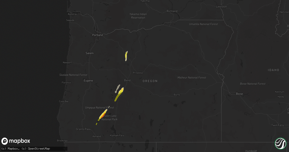
Hail Map in Oregon on June 11, 2020
Get this storm
June 11 map
$229
one time, instant access
Download today. No call, no setup
Keep the $229
Bought the map and want the full workflow? Apply the entire $229 to a subscription within 7 days. None of it is wasted.
Every map, not just this one
This buys you this map. Subscription and you get every map we run, in the markets you choose from a few cities to whole states to nationwide. Plus real-time alerts the moment a storm fires.
Contact data
Name, contact info, occupancy, even credit band for addresses in the footprint. You go from where it hit to who to call.
Become the source they trust
Unlimited branding weather history reports on demand. You already have the documented answer ready for the property owner, and you are the one who showed up with it.
Property data and RoofTrace estimates
Pull up any address you have got, its value and the exact code rules for that jurisdiction, straight from One Click Code. Then RoofTrace estimates the squares, pitch, and roof value, priced the way you price.
Storm reports in Oregon
Oregon
| Date | Description |
|---|---|
| 06/11/20203:37 AM CDT | At 836 PM PDT, a severe thunderstorm was located near Crescent, or 16 miles southwest of La Pine, moving northeast at 35 mph. HAZARD...60 mph wind gusts and half dollar size hail. SOURCE...Radar indicated. IMPACT...Hail damage to vehicles is expected. Expect wind damage to roofs, siding, and trees. Locations impacted include... Bend, La Pine, Three Rivers and Sunriver. |
| 06/11/20203:03 AM CDT | At 802 PM PDT, a severe thunderstorm was located near Digit Point Campground At Miller Lake, or 28 miles north of Crater Lake, moving northeast at 25 mph. HAZARD...60 mph wind gusts and quarter size hail. SOURCE...Radar indicated. IMPACT...Hail damage to vehicles is expected. Expect wind damage to roofs, siding, and trees. Locations impacted include... East Lemolo Campground, Odell Lake, Crescent Lake, Crescent, Digit Point Campground At Miller Lake and Gilchrist.This includes the following highways... US 97 in Oregon between mile markers 173 and 191. Highway 31 in Oregon between mile markers 3 and 6. Highway 58 in Oregon between mile markers 66 and 84. |
| 06/11/20202:07 AM CDT | At 707 PM PDT, a severe thunderstorm was located near Fish Lake Snow Park, or 25 miles northeast of Ashland, moving northeast at 35 mph. HAZARD...60 mph wind gusts and quarter size hail. SOURCE...Radar indicated. IMPACT...Hail damage to vehicles is expected. Expect wind damage to roofs, siding, and trees. Locations impacted include... Fort Klamath.This includes the following highways... Lake of the Woods Highway 140 in Oregon between mile markers 28 and29. Highway 62 in Oregon between mile markers 88 and 95. |
| 06/11/20201:58 AM CDT | At 658 PM PDT, a severe thunderstorm was located over Rogue Gorge, or 15 miles west of Crater Lake, moving northeast at 40 mph. HAZARD...60 mph wind gusts and quarter size hail. SOURCE...Radar indicated. IMPACT...Hail damage to vehicles is expected. Expect wind damage to roofs, siding, and trees. Locations impacted include... East Lemolo Campground, Highway 138 Diamond Lake Summit, Union Creek, Diamond Lake, Thousand Springs Sno-Park, Broken Arrow Campground, Clearwater Falls Recreation Site, Thielsen View Campground, Whitehorse Falls Recreation Site, Rogue Gorge and Natural Bridge Campground.This includes the following highways... Highway 230 in Oregon between mile markers 1 and 23. Highway 138 in Oregon between mile markers 63 and 85. Highway 62 in Oregon between mile markers 51 and 64. |
| 06/11/20201:23 AM CDT | At 623 PM PDT, a severe thunderstorm was located over Rogue Elk Park, or 22 miles north of Medford, moving north at 35 mph. HAZARD...60 mph wind gusts and quarter size hail. SOURCE...Radar indicated. IMPACT...Hail damage to vehicles is expected. Expect wind damage to roofs, siding, and trees. Locations impacted include... Shady Cove, Union Creek, Lost Creek Lake, Rogue Gorge, Casey State Park, Joseph Stewart State Park, Rogue Elk Park, Natural Bridge Campground and Trail.This includes the following highways... Highway 230 in Oregon between mile markers 1 and 2. Highway 62 in Oregon between mile markers 18 and 41, and betweenmile markers 49 and 59. |
| 06/11/202012:13 AM CDT | At 512 PM PDT, a severe thunderstorm was located over southeastern Warm Springs Reservation, or 13 miles northwest of Madras, moving north at 25 mph. HAZARD...60 mph wind gusts and quarter size hail. SOURCE...Radar indicated. IMPACT...Hail damage to vehicles is expected. Expect wind damage to roofs, siding, and trees. Locations impacted include... Madras, Maupin, Warm Springs Reservation, Wapinitia, Gateway, Pine Grove, Wamic, South Junction, Warm Springs, Simnasho and Tygh Valley. |
| 06/10/202011:15 PM CDT | Time estimated from radar. |
| 06/10/202011:10 PM CDT | Hail ranged from quarter sized to half dollar sized. Reports via local broadcast media. |
| 06/10/20207:22 PM CDT | Warm springs police department received reports of a large hail storm along highway 26. Received a report of hail at least a quarter size from the public. |
All States Impacted by Hail Map on June 11, 2020
Cities Impacted by Hail Map on June 11, 2020
- Guymon, OK
- Goodwell, OK
- Grafton, ND
- Glasston, ND
- Cavalier, ND
- Neche, ND
- Bathgate, ND
- Hamilton, ND
- Plains, KS
- Kismet, KS
- Prospect, OR
- Argyle, MN
- Bend, OR
- La Pine, OR
- Saint Thomas, ND
- Drayton, ND
- Minto, ND
- Trail, OR
- Sarasota, FL
- Venice, FL
- Warm Springs, OR
- Maupin, OR
- Dodge City, KS
- Ford, KS
- Wright, KS
- Satanta, KS
- Stephen, MN
- Ruskin, FL
- Idleyld Park, OR
- Ashland, OR
- Pratt, KS
- Cunningham, KS
- Medford, OR
- Central Point, OR
- Alamogordo, NM
- Chemult, OR
- Las Cruces, NM
- Rotonda West, FL
- North Port, FL
- Shady Cove, OR
- Spearville, KS
- Greenleaf, WI
- Mishicot, WI
- Maribel, WI
- Denmark, WI
- De Pere, WI
- Two Rivers, WI
- Muskego, WI
- Franklin, WI
- Big Bend, WI
- Wales, WI
- Mukwonago, WI
- North Prairie, WI
- New Berlin, WI
- Waukesha, WI
- Eagle Point, OR
- Crescent, OR


