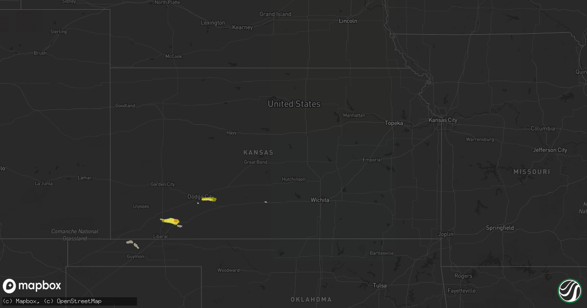
Hail Map in Kansas on June 11, 2020
Get this storm
June 11 map
$229
one time, instant access
Download today. No call, no setup
Keep the $229
Bought the map and want the full workflow? Apply the entire $229 to a subscription within 7 days. None of it is wasted.
Every map, not just this one
This buys you this map. Subscription and you get every map we run, in the markets you choose from a few cities to whole states to nationwide. Plus real-time alerts the moment a storm fires.
Contact data
Name, contact info, occupancy, even credit band for addresses in the footprint. You go from where it hit to who to call.
Become the source they trust
Unlimited branding weather history reports on demand. You already have the documented answer ready for the property owner, and you are the one who showed up with it.
Property data and RoofTrace estimates
Pull up any address you have got, its value and the exact code rules for that jurisdiction, straight from One Click Code. Then RoofTrace estimates the squares, pitch, and roof value, priced the way you price.
Storm reports in Kansas
Kansas
| Date | Description |
|---|---|
| 06/11/20205:55 PM CDT | A local report indicates 1.00 inch wind near 3 SE FT. DODGE |
| 06/11/20201:08 AM CDT | At 608 PM CDT, a severe thunderstorm was located 6 miles north of Optima, or 12 miles north of Guymon, moving east at 20 mph. HAZARD...60 mph wind gusts and quarter size hail. SOURCE...Radar indicated. IMPACT...Minor damage to roofs, siding, and trees is possible. Hail damage to vehicles is expected. Locations impacted include... Hooker, Tyrone, Optima, Eva, Hough, Baker, Adams and Turpin. |
| 06/11/202012:57 AM CDT | At 557 PM CDT, a severe thunderstorm was located near Ford, moving east at 25 mph. HAZARD...Quarter size hail. SOURCE...Radar indicated. IMPACT...Damage to vehicles is expected. Locations impacted include... Ford, Windhorst and Ft. Dodge. |
| 06/11/202012:21 AM CDT | At 520 PM CDT, a severe thunderstorm was located 6 miles northwest of Hooker, or 18 miles south of Hugoton, moving east at 30 mph. HAZARD...60 mph wind gusts and quarter size hail. SOURCE...Radar indicated. IMPACT...Minor damage to roofs, siding, and trees is possible. Hail damage to vehicles is expected. Locations impacted include... Hooker, Tyrone, Optima, Baker, Adams, Boyd and Turpin. |
| 06/11/202012:02 AM CDT | At 502 PM CDT, a severe thunderstorm was located near Plains, or 7 miles north of Kismet, moving east at 30 mph. HAZARD...Half dollar size hail. SOURCE...Radar indicated. IMPACT...Damage to vehicles is expected. Locations impacted include... Meade, Missler and Plains. |
All States Impacted by Hail Map on June 11, 2020
Cities Impacted by Hail Map on June 11, 2020
- Guymon, OK
- Goodwell, OK
- Grafton, ND
- Glasston, ND
- Cavalier, ND
- Neche, ND
- Bathgate, ND
- Hamilton, ND
- Plains, KS
- Kismet, KS
- Prospect, OR
- Argyle, MN
- Bend, OR
- La Pine, OR
- Saint Thomas, ND
- Drayton, ND
- Minto, ND
- Trail, OR
- Sarasota, FL
- Venice, FL
- Warm Springs, OR
- Maupin, OR
- Dodge City, KS
- Ford, KS
- Wright, KS
- Satanta, KS
- Stephen, MN
- Ruskin, FL
- Idleyld Park, OR
- Ashland, OR
- Pratt, KS
- Cunningham, KS
- Medford, OR
- Central Point, OR
- Alamogordo, NM
- Chemult, OR
- Las Cruces, NM
- Rotonda West, FL
- North Port, FL
- Shady Cove, OR
- Spearville, KS
- Greenleaf, WI
- Mishicot, WI
- Maribel, WI
- Denmark, WI
- De Pere, WI
- Two Rivers, WI
- Muskego, WI
- Franklin, WI
- Big Bend, WI
- Wales, WI
- Mukwonago, WI
- North Prairie, WI
- New Berlin, WI
- Waukesha, WI
- Eagle Point, OR
- Crescent, OR


