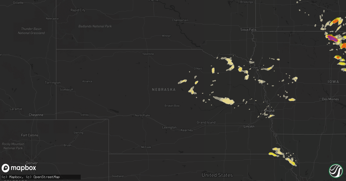
Hail Map in Nebraska on June 9, 2018
Get this storm
June 9 map
$229
one time, instant access
Download today. No call, no setup
Keep the $229
Bought the map and want the full workflow? Apply the entire $229 to a subscription within 7 days. None of it is wasted.
Every map, not just this one
This buys you this map. Subscription and you get every map we run, in the markets you choose from a few cities to whole states to nationwide. Plus real-time alerts the moment a storm fires.
Contact data
Name, contact info, occupancy, even credit band for addresses in the footprint. You go from where it hit to who to call.
Become the source they trust
Unlimited branding weather history reports on demand. You already have the documented answer ready for the property owner, and you are the one who showed up with it.
Property data and RoofTrace estimates
Pull up any address you have got, its value and the exact code rules for that jurisdiction, straight from One Click Code. Then RoofTrace estimates the squares, pitch, and roof value, priced the way you price.
Storm reports in Nebraska
Nebraska
| Date | Description |
|---|---|
| 06/09/201810:07 AM CDT | A local report indicates 70 MPH wind near 5 SSE CRESTON |
| 06/09/20187:55 AM CDT | At 1255 AM CDT, severe thunderstorms were located along a line extending from 6 miles northwest of Elgin to 8 miles west of Petersburg to Spalding to near North Loup, moving southeast at 45 mph. HAZARD...60 mph wind gusts. SOURCE...Radar indicated. IMPACT...Expect damage to roofs, siding, and trees. Locations impacted include... Albion, Battle Creek, Newman Grove, St. Edward, Elgin, Cedar Rapids, Petersburg, Oakdale, Meadow Grove, Lindsay, Tilden, Primrose, Cornlea, Loretto and The Highway 14 And 56 Junction. |
| 06/09/20187:39 AM CDT | At 1237 AM CDT, severe thunderstorms were located along a line extending from near Arnold to near Sargent, moving south at 45 mph. HAZARD...60 mph wind gusts. SOURCE...Radar indicated. IMPACT...Expect damage to roofs, siding, and trees. Locations impacted include... Broken Bow, Arnold, Callaway, Sargent, Ansley, Merna, Mason City, Oconto, Anselmo, Comstock, Berwyn, Victoria Springs State Recreation Area, Weissert, Westerville, Lillian, Walworth, Lodi, Buckeye, Finchville and Round Valley.This includes the following highways... Highway 183 between mile markers 73 and 121. Highway 2 between mile markers 253 and 307. Highway 92 between mile markers 248 and 308. |
| 06/09/20187:38 AM CDT | At 1238 AM CDT, a severe thunderstorm was located 11 miles northwest of Bartlett, or 26 miles northeast of Burwell, moving east at 35 mph. HAZARD...60 mph wind gusts and half dollar size hail. SOURCE...Radar indicated. IMPACT...Hail damage to vehicles is expected. Expect wind damage to roofs, siding, and trees. Locations impacted include... Burwell, Bartlett, Ericson, Knievels Corner, Cumminsville, Four Corners, Pibel Lake State Recreation Area, Buffalo Flats, Goose Lake State Wildlife Management Area and Gables.This includes Highway 281 between mile markers 132 and 160. |
| 06/09/20187:37 AM CDT | At 1236 AM CDT, severe thunderstorms were located along a line extending from 7 miles north of Spalding to near Ord to 6 miles southeast of Weissert, moving south at 45 mph. HAZARD...60 mph wind gusts along thunderstorm outflow SOURCE...Radar indicated. In addition, at 1231 AM CDT, the Ord airport measured a 64 MPH gust. IMPACT...Expect damage to roofs, siding, and trees. Locations impacted include... Ord, Greeley, Spalding, Scotia, Arcadia, North Loup, Elyria and Fort Hartsuff State Park. |
| 06/09/20185:50 AM CDT | At 1049 PM CDT, a severe thunderstorm was located just southwest of Kearney, moving east at 15 mph. HAZARD...60 mph wind gusts and quarter size hail. SOURCE...Radar indicated. IMPACT...Hail damage to vehicles is expected. Expect wind damage to roofs, siding, and trees. Locations impacted include... Mainly rural areas just south of Kearney. This includes Interstate 80 between mile markers 267 and 282. |
| 06/09/20183:05 AM CDT | At 805 PM CDT, a severe thunderstorm was located over Hamlin, moving southeast at 20 mph. HAZARD...60 mph wind gusts and nickel size hail. SOURCE...Radar indicated. IMPACT...Expect damage to roofs, siding, and trees. Locations impacted include... Hiawatha, Robinson, Reserve and Hamlin. |
| 06/09/20182:44 AM CDT | At 743 PM CDT, a severe thunderstorm was located near Morrill, moving southeast at 20 mph. HAZARD...60 mph wind gusts and quarter size hail. SOURCE...Radar indicated. IMPACT...Hail damage to vehicles is expected. Expect wind damage to roofs, siding, and trees. Locations impacted include... Hiawatha, Sabetha, Robinson, Morrill, Reserve and Hamlin. |
| 06/09/20182:09 AM CDT | At 708 PM CDT, a severe thunderstorm was located near Reserve, moving southeast at 20 mph. HAZARD...60 mph wind gusts and quarter size hail. SOURCE...Trained weather spotters reported 60 mph wind gusts in Falls City at 705 pm CDT. IMPACT...Hail damage to vehicles is expected. Expect wind damage to roofs, siding, and trees. Locations impacted include... Hiawatha, Robinson and Reserve. |
| 06/09/20181:41 AM CDT | At 641 PM CDT, a severe thunderstorm was located 5 miles east of Bern, moving east at 20 mph. HAZARD...60 mph wind gusts and quarter size hail. SOURCE...Radar indicated. IMPACT...Hail damage to vehicles is expected. Expect wind damage to roofs, siding, and trees. Locations impacted include... Sabetha, Morrill, Bern, Reserve and Hamlin. |
| 06/08/201811:15 PM CDT | At 415 AM CDT, severe thunderstorms were located along a line extending from 3 miles northwest of Minden to 9 miles northeast of Union, moving east at 40 mph. HAZARD...60 mph wind gusts. SOURCE...Radar indicated. IMPACT...Expect damage to roofs, siding, and trees. Locations impacted include... Red Oak, Glenwood, Shenandoah, Oakland, Avoca, Malvern, Treynor, Underwood, Carson, Essex, Walnut, Stanton, Shelby, Minden, Pacific Junction, Emerson, Elliott, Persia, Macedonia and Tabor.This includes the following highways... Interstate 29 between mile markers 20 and 29. Interstate 80 in Iowa between mile markers 14 and 48. |
| 06/08/201810:00 PM CDT | At 300 AM CDT, severe thunderstorms were located along a line extending from near Howells to near Brainard, moving east at 40 mph. HAZARD...60 mph wind gusts. SOURCE...Radar indicated. IMPACT...Expect damage to roofs, siding, and trees. Locations impacted include... Fremont, Wahoo, North Bend, Scribner, Hooper, Cedar Bluffs, Mead, Nickerson, Inglewood, Weston, Prague, Snyder, Uehling, Morse Bluff, Malmo, Colon, Winslow, Rogers, Linwood and Abie. |
| 06/08/20189:53 PM CDT | At 253 AM CDT, severe thunderstorms were located along a line extending from 4 miles west of Brainard to 5 miles east of Beaver Crossing to 3 miles northwest of Bruning, moving east at 40 mph. HAZARD...60 mph wind gusts. SOURCE...Radar indicated. IMPACT...Expect damage to roofs, siding, and trees. Locations impacted include... Lincoln, Seward, Crete, Milford, Wilber, Friend, Dorchester, Valparaiso, Beaver Crossing, Western, Garland, Pleasant Dale, Bee, Ceresco, Malcolm, Denton, Raymond, Daykin, Davey and Goehner.This includes Interstate 80 in Nebraska between mile markers 373 and405. |
| 06/08/20189:45 PM CDT | At 244 AM CDT, a severe thunderstorm was located 6 miles south of Stanton, or 16 miles southeast of Norfolk, moving east at 35 mph. HAZARD...60 mph wind gusts and quarter size hail. SOURCE...Radar indicated. IMPACT...Hail damage to vehicles is expected. Expect wind damage to roofs, siding, and trees. Locations impacted include... West Point, Stanton, Wisner, Beemer, The Highway 15 And 32 Junction, The Highway 9 And 51 Junction, 10 Miles West Of West Point and 8 Miles South Of Stanton. |
| 06/08/20189:38 PM CDT | At 237 AM CDT, severe thunderstorms were located along a line extending from 5 miles east of Platte Center to Shelby to near Henderson, moving east at 30 mph. HAZARD...60 mph wind gusts and quarter size hail. SOURCE...Radar indicated. IMPACT...Hail damage to vehicles is expected. Expect wind damage to roofs, siding, and trees. Locations impacted include... Columbus, Schuyler, David City, Utica, Bellwood, Beaver Crossing, Rising City, Brainard, Staplehurst, Dwight, Ulysses, Cordova, Octavia, Bruno, Richland, Garrison, Surprise, College View Trailer Park, Camp Pawnee and Shell Creek Elementary School.This includes Interstate 80 in Nebraska between mile markers 366 and371. |
| 06/08/20189:33 PM CDT | At 233 AM CDT, severe thunderstorms were located along a line extending from near Glenvil to near Campbell to 6 miles east of Oxford, moving southeast at 45 mph. HAZARD...60 mph wind gusts. SOURCE...Radar indicated. In addition, at 223 AM CDT, Hastings airport gusted to 62 MPH. IMPACT...Expect damage to roofs, siding, and trees. Locations impacted include... Alma, Franklin, Blue Hill, Oxford, Orleans, Hildreth, Wilcox, Campbell, Bladen, Roseland, Stamford, Republican City, Upland, Naponee, Bloomington, Ayr, Huntley, Ragan, Cowles and Rosemont. |
| 06/08/20189:31 PM CDT | At 230 AM CDT, severe thunderstorm outflow winds were located along a line extending from near Shelby to near Lushton to Glenvil, moving southeast at 60 mph. HAZARD...60 mph wind gusts. SOURCE...Radar indicated. In addition, at 223 AM CDT, Hastings airport gusted to 62 MPH. IMPACT...Expect damage to roofs, siding, and trees. Locations impacted include... York, Geneva, Sutton, Harvard, Henderson, Clay Center, Exeter, Fairmont, Edgar, McCool Junction, Fairfield, Shickley, Glenvil, Lawrence, Davenport, Milligan, Bruning, Bradshaw, Waco and Benedict.This includes Interstate 80 between mile markers 338 and 365. |
| 06/08/20189:13 PM CDT | At 213 AM CDT, a severe thunderstorm was located 6 miles southwest of Madison, or 19 miles south of Norfolk, moving east at 40 mph. HAZARD...60 mph wind gusts and quarter size hail. SOURCE...Radar indicated. IMPACT...Hail damage to vehicles is expected. Expect wind damage to roofs, siding, and trees. Locations impacted include... Madison, Clarkson, Leigh, Creston, Humphrey, Tarnov, Cornlea, Maple Creek Recreation Area, Camp Luther and 8 Miles South Of Stanton. |
| 06/08/20189:06 PM CDT | At 205 AM CDT, severe thunderstorm outflow winds were located along a line extending from near Kenesaw to 7 miles north of Minden to near Bertrand, moving south at 50 mph. HAZARD...60 mph wind gusts. SOURCE...Radar indicated. In addition, at 159 AM CDT, Kearney airport gusted to 59 MPH. IMPACT...Expect damage to roofs, siding, and trees. Locations impacted include... Kearney, Holdrege, Minden, Axtell, Loomis, Hildreth, Wilcox, Funk, Upland, Atlanta, Heartwell, Norman and Ragan.This includes Interstate 80 between mile markers 264 and 288. |
| 06/08/20189:04 PM CDT | At 204 AM CDT, a severe thunderstorm was located 4 miles southwest of Battle Creek, or 13 miles southwest of Norfolk, moving east at 25 mph. HAZARD...60 mph wind gusts. SOURCE...Radar indicated. IMPACT...Expect damage to roofs, siding, and trees. Locations impacted include... Norfolk, Battle Creek, Meadow Grove and Hadar. |
| 06/08/20188:59 PM CDT | At 158 AM CDT, severe thunderstorm outflow winds were located along a line extending from near Clarks to near Phillips to near Kenesaw, moving southeast at 60 mph. HAZARD...60 mph wind gusts or higher. SOURCE...Radar indicated. In addition, at 154 AM CDT, Grand Island airport gusted to 74 MPH. IMPACT...Expect damage to roofs, siding, and trees. Locations impacted include... Grand Island, Hastings, York, Aurora, Central City, Wood River, Harvard, Henderson, Kenesaw, Doniphan, Juniata, Alda, Hampton, Clarks, Giltner, Polk, Glenvil, Phillips, Chapman and Bradshaw.This includes Interstate 80 between mile markers 293 and 346. |
| 06/08/20188:47 PM CDT | At 147 AM CDT, a severe thunderstorm was located near Newman Grove, or 28 miles southwest of Norfolk, moving east at 40 mph. HAZARD...60 mph wind gusts. SOURCE...Radar indicated. IMPACT...Expect damage to roofs, siding, and trees. Locations impacted include... Madison, Newman Grove, Lindsay, Humphrey and Cornlea. |
| 06/08/20188:43 PM CDT | At 143 AM MDT, a severe thunderstorm was located about 3 miles northeast of Hyannis, or 31 miles west of Mullen, moving east at 30 mph. HAZARD...60 mph wind gusts and half dollar size hail. SOURCE...Radar indicated. IMPACT...Hail damage to vehicles is expected. Expect wind damage to roofs, siding, and trees. Locations impacted include... Whitman and Duluth. This includes the following highways... Highway 2 between mile markers 148 and 164. Highway 61 near mile marker 165. |
| 06/08/20188:29 PM CDT | At 129 AM MDT, a severe thunderstorm was located 12 miles east of Whitman, or 13 miles west of Mullen, moving east at 20 mph. HAZARD...60 mph wind gusts and quarter size hail. SOURCE...Radar indicated. IMPACT...Hail damage to vehicles is expected. Expect wind damage to roofs, siding, and trees. Locations impacted include... Mullen, Hecla and Weir. This includes the following highways... Highway 2 between mile markers 166 and 186. Highway 97 between mile markers 58 and 74. |
| 06/08/20188:00 PM CDT | At 1259 AM CDT, severe thunderstorm outflow winds were located along a line extending from near Spalding to near Sherman Reservoir Dam to near Oconto, moving south at 45 mph. HAZARD...60 mph wind gusts. SOURCE...Radar indicated. In addition, at 1231 AM CDT, the Ord airport gusted to 64 MPH. IMPACT...Expect damage to roofs, siding, and trees. Locations impacted include... Lexington, Ord, Cozad, Gothenburg, Greeley, St. Paul, Ravenna, Fullerton, Loup City, Spalding, Palmer, Pleasanton, Scotia, Arcadia, Dannebrog, North Loup, Wolbach, Litchfield, Sumner and Elba.This includes Interstate 80 between mile markers 209 and 231. |
| 06/08/20187:09 PM CDT | A local report indicates 68 MPH wind near 1 NNE FALLS CITY |
| 06/08/20187:00 PM CDT | Pea size hail. |
All States Impacted by Hail Map on June 9, 2018
Cities Impacted by Hail Map on June 9, 2018
- Spring Grove, MN
- Decorah, IA
- Mabel, MN
- Winchester, VA
- Clear Brook, VA
- Stephens City, VA
- White Post, VA
- Pierson, IA
- Anthon, IA
- Correctionville, IA
- Moville, IA
- Mosquero, NM
- Moselle, MS
- Ellisville, MS
- Ellendale, MN
- Clarks Grove, MN
- Hartland, MN
- Albert Lea, MN
- Alden, MN
- Oneonta, AL
- Norway, IA
- Marengo, IA
- Blairstown, IA
- Watkins, IA
- Falls City, NE
- Geneva, IA
- Hampton, IA
- Fertile, IA
- Clear Lake, IA
- Hanlontown, IA
- Manly, IA
- Mason City, IA
- Preston, IA
- Atkinson, IL
- Cambridge, IL
- Kewanee, IL
- Chenoa, IL
- Pontiac, IL
- Edinburg, VA
- Shorterville, AL
- Abbeville, AL
- Newville, AL
- Mount Auburn, IA
- Vinton, IA
- Ottawa, KS
- Prosperity, SC
- Little Mountain, SC
- Chapin, SC
- Moores Hill, IN
- Aurora, IN
- Iowa City, IA
- Keswick, IA
- Barnes City, IA
- What Cheer, IA
- Gibson, IA
- Lawton, IA
- Papillion, NE
- Omaha, NE
- Springfield, NE
- La Vista, NE
- Chatsworth, IL
- Roberts, IL
- Thawville, IL
- Alexander, IA
- Latimer, IA
- Coulter, IA
- Dupo, IL
- Columbia, IL
- East Carondelet, IL
- Washington, IA
- Iowa Falls, IA
- Ackley, IA
- Sidell, IL
- Indianola, IL
- Fairmount, IL
- Offutt Afb, NE
- Bellevue, NE
- Montour, IA
- Toledo, IA
- Garwin, IA
- Bixby, MO
- Montevallo, AL
- Easton, MN
- Delavan, MN
- Georgetown, MN
- Argusville, ND
- Carroll, IA
- Breda, IA
- Cedar Rapids, IA
- Humboldt, IL
- Charleston, IL
- Mattoon, IL
- Sheffield, IA
- Dougherty, IA
- Creighton, NE
- Royal, NE
- Winnetoon, NE
- Brunswick, NE
- Charter Oak, IA
- Gillette, WY
- Dana, IL
- Benson, IL
- Minonk, IL
- Chinook, MT
- Harlem, MT
- Salem, NE
- Morrill, KS
- Dawson, NE
- Sabetha, KS
- Odell, IL
- Dwight, IL
- Emington, IL
- Homer, IL
- Saint Joseph, IL
- Sidney, IL
- Heathsville, VA
- Kilmarnock, VA
- Cologne, MN
- Chaska, MN
- Carver, MN
- Morton, MS
- Amana, IA
- Avon, SD
- Hall, MT
- Philipsburg, MT
- Drummond, MT
- Corvallis, MT
- Rudd, IA
- Marble Rock, IA
- Greene, IA
- Charles City, IA
- Nora Springs, IA
- Rockford, IA
- Tinnie, NM
- Salem, IL
- Odin, IL
- Wellman, IA
- Curryville, MO
- Vandalia, MO
- Salem, MO
- Tallahassee, FL
- Keystone Heights, FL
- Brayton, IA
- Atlantic, IA
- Walnut, IA
- Audubon, IA
- Marne, IA
- Kimballton, IA
- Harlan, IA
- Elk Horn, IA
- Exira, IA
- Keystone, IA
- Van Horne, IA
- Elberon, IA
- Buckatunna, MS
- Glenville, MN
- Tripp, SD
- Scotland, SD
- Craig, MO
- Sullivan, IN
- Merom, IN
- Marshfield, MO
- Seymour, MO
- Laurel Hill, FL
- Crestview, FL
- South English, IA
- Webster, IA
- North English, IA
- Monticello, IL
- Wellsburg, IA
- Thurston, NE
- Pender, NE
- Emerson, NE
- Wakefield, NE
- Tipton, IA
- Wadena, IA
- Fayette, IA
- Rochester, IL
- Pecos, TX
- Kensett, IA
- Moccasin, MT
- Stanford, MT
- Wells, MN
- Denton, MT
- Winifred, MT
- French Lick, IN
- Paoli, IN
- Verdigre, NE
- Odebolt, IA
- Scotia, NE
- Gladstone, VA
- Arlington, IA
- Volga, IA
- Alzada, MT
- Belle Fourche, SD
- Niobrara, NE
- Otter, MT
- Tappahannock, VA
- Covington, IN
- Onawa, IA
- Whiting, IA
- Griggsville, IL
- Hammond, MT
- Harmony, MN
- Cresco, IA
- Shipman, IL
- Brighton, IL
- Vienna, MD
- Waynesville, OH
- Roodhouse, IL
- Greenfield, IL
- Frost, MN
- Bricelyn, MN
- Astoria, IL
- Rushville, IL
- Laurel, NE
- Dixon, NE
- North Henderson, IL
- Rio, IL
- Dysart, IA
- Parnell, IA
- Saint Louis, MO
- Chambers, NE
- Georgetown, IL
- Ridge Farm, IL
- Mobile, AL
- Monroe, NE
- Columbus, NE
- Platte Center, NE
- Genoa, NE
- Palestine, IL
- Jordan, MN
- Strafford, MO
- Humboldt, NE
- Hiawatha, KS
- Bern, KS
- Centralia, IL
- Sandoval, IL
- Hoyleton, IL
- Gurdon, AR
- Emmons, MN
- Northwood, IA
- Hayward, MN
- Shellsburg, IA
- Urbana, IA
- Dodge, NE
- Rogers, NE
- Weems, VA
- Lancaster, VA
- Hillsboro, ND
- Parkersburg, IA
- Homestead, IA
- Eldora, IA
- Forest City, IA
- Leland, IA
- La Porte City, IA
- Jesup, IA
- Alamo, TN
- Hollandale, MN
- Crofton, NE
- Kingsley, IA
- Bronson, IA
- Troy, KS
- Hettick, IL
- Elk Point, SD
- Jefferson, SD
- Conchas Dam, NM
- Ohatchee, AL
- Hoopeston, IL
- Rankin, IL
- Wellington, IL
- Bismarck, MO
- Doe Run, MO
- Ironton, MO
- Plymouth, IL
- Macomb, IL
- Littleton, IL
- Industry, IL
- Bluffs, IL
- Chapin, IL
- Arenzville, IL
- Versailles, IL
- Jacksonville, IL
- Meredosia, IL
- Beardstown, IL
- Mount Sterling, IL
- Chambersburg, IL
- Downs, IL
- Bloomington, IL
- Mason, IL
- Watson, IL
- Edgewood, IL
- Hutsonville, IL
- Robinson, IL
- Allen, NE
- Hartington, NE
- Augusta, WV
- Delray, WV
- Cissna Park, IL
- Milford, IL
- Upland, IN
- Hartford City, IN
- Montpelier, IN
- Grundy Center, IA
- Frisco City, AL
- Middletown, VA
- Birmingham, AL
- Bessemer, AL
- Golden Gate, IL
- Coffee Creek, MT
- Janesville, IA
- Waterloo, IA
- Cedar Falls, IA
- Waverly, IA
- New Hartford, IA
- Granite City, IL
- Bird Island, MN
- Morton, MN
- Franklin, MN
- Cherokee, IA
- Lake Mills, IA
- Thompson, IA
- Belle Plaine, MN
- Henderson, MN
- Le Sueur, MN
- West Union, IA
- Walthill, NE
- Marion Junction, AL
- Buena Vista, GA
- Bloomfield, NE
- Fordyce, NE
- Lloyd, MT
- Muncie, IN
- Blakely, GA
- Ryan, IA
- Manchester, IA
- Fort Washington, MD
- Accokeek, MD
- Waterloo, IL
- Valmeyer, IL
- Fults, IL
- Headland, AL
- Ozark, AL
- Yazoo City, MS
- Joice, IA
- Amelia, NE
- Vermont, IL
- Browning, IL
- Independence, IA
- Millville, NJ
- Bridgeton, NJ
- Cambridge, MD
- Rhodesdale, MD
- Goose Lake, IA
- Bryant, IA
- Charlotte, IA
- Gladbrook, IA
- Reinbeck, IA
- Neligh, NE
- Tuskegee, AL
- Chelsea, IA
- Clutier, IA
- Stockport, IA
- Lockridge, IA
- Clifton, VA
- Prairie, MS
- Lakeland, GA
- Naylor, GA
- Altona, IL
- Galva, IL
- Bishop Hill, IL
- Semmes, AL
- Wathena, KS
- Bonne Terre, MO
- Fairfield, IA
- Greeley, NE
- Osawatomie, KS
- Seaford, DE
- Bethel, DE
- Atkins, IA
- Palo, IA
- Vining, IA
- Belle Plaine, IA
- Luzerne, IA
- Newhall, IA
- Walford, IA
- Fairfax, IA
- South Amana, IA
- Swisher, IA
- Hiawatha, IA
- Ladora, IA
- North Liberty, IA
- Middle Amana, IA
- Victor, IA
- Oxford, IA
- Gaston, IN
- Atwood, IL
- Arthur, IL
- Lovington, IL
- Highland, KS
- Bendena, KS
- Hogeland, MT
- Monroe, VA
- Madison Heights, VA
- Thomson, IL
- Chadwick, IL
- Morrison, IL
- Milledgeville, IL
- Fulton, IL
- Albion, NE
- Primrose, NE
- Gardner, ND
- Strawberry Point, IA
- Waterbury, NE
- Hubbard, NE
- Jackson, NE
- Tama, IA
- Carlyle, IL
- England, AR
- Enterprise, AL
- Rowley, IA
- Le Center, MN
- Woodbine, IA
- Albany, IL
- Hillsdale, IL
- Camden, AL
- Alberta, AL
- Catherine, AL
- Pine Hill, AL
- Bryant, IN
- Pennville, IN
- Dunkirk, IN
- Osage, IA
- Stanley, IA
- Hays, MT
- Adair, IL
- Upper Marlboro, MD
- Aladdin, WY
- Ericson, NE
- Ord, NE
- Burwell, NE
- Martinsville, IL
- Casey, IL
- Big Sandy, MT
- Pacific Junction, IA
- Council Bluffs, IA
- Glenwood, IA
- Prattville, AL
- Concord, IL
- Holt, FL
- La Fayette, IL
- Claude, TX
- Capitol, MT
- Hulett, WY
- Dike, IA
- Dozier, AL
- Perry, IL
- Winchester, IL
- Ambrose, GA
- Broxton, GA
- Ponca, NE
- Westfield, IA
- Alpha, IL
- Mineral, VA
- Troy, AL
- Jack, AL
- Temple Hills, MD
- Suitland, MD
- Mechanicsburg, OH
- Wickliffe, KY
- Charleston, MO
- Moss Point, MS
- Bunker, MO
- Warwick, GA
- Sylvester, GA
- Lime Springs, IA
- Chester, IA
- Princeton, IL
- Buda, IL
- Sheffield, IL
- Tiskilwa, IL
- Wyanet, IL
- Bowen, IL
- Augusta, IL
- Huntsville, IL
- Patoka, IL
- Bartelso, IL
- Hoffman, IL
- Kell, IL
- Williamsport, IN
- Middletown, IN
- Winthrop, IA
- Quasqueton, IA
- Hazleton, IA
- Masonville, IA
- Fairbank, IA
- Rantoul, IL
- Mount Pleasant, IA
- Concord, NE
- Riceville, IA
- Sterling, IL
- Gretna, NE
- Marion, IN
- Saraland, AL
- Chunchula, AL
- Bellwood, NE
- Randolph, NE
- Coleridge, NE
- Perry, MO
- Eminence, MO
- Carlisle, IN
- Guernsey, IA
- Verdon, NE
- Sacred Heart, MN
- Olivia, MN
- Grinnell, IA
- Gilman, IA
- Remsen, IA
- Marcus, IA
- Stonington, IL
- New Madison, OH
- Arcanum, OH
- Oregon, MO
- Five Points, AL
- Roanoke, AL
- Shirley, IL
- McLean, IL
- Columbus, GA
- Mclean, NE
- Rockwell, IA
- Monmouth, IL
- Theodore, AL
- Irvington, AL
- Grand Bay, AL
- Fredericksburg, IA
- New Hampton, IA
- Sumner, IA
- Frederika, IA
- Tripoli, IA
- Nashua, IA
- Ionia, IA
- Floyd, IA
- Prince Frederick, MD
- Huntingtown, MD
- Humphrey, NE
- Alexandria, VA
- Park Hills, MO
- Irondale, MO
- Aplington, IA
- Wabash, IN
- Taylorville, IL
- Paola, KS
- Opp, AL
- Walnut, IL
- Tampico, IL
- Hamilton, GA
- Saint Joseph, MO
- Paxton, IL
- Mount Olive, IL
- Klemme, IA
- Swaledale, IA
- Thornton, IA
- Seaton, IL
- Aledo, IL
- Alexis, IL
- Viola, IL
- Traer, IA
- Blomkest, MN
- Milton, FL
- Steamboat Rock, IA
- Tyndall, SD
- Dieterich, IL
- Irwin, IA
- Defiance, IA
- Le Roy, IL
- White Cloud, KS
- Robinson, KS
- Rulo, NE
- Lindsay, NE
- Saint Edward, NE
- Amherst, VA
- Alma, GA
- Mankato, MN
- Janesville, MN
- Saint Clair, MN
- Elma, IA
- Westgate, IA
- Saint Ansgar, IA
- Plymouth, IA
- Plainfield, IA
- Ventura, IA
- Allison, IA
- Garner, IA
- Scarville, IA
- Grafton, IA
- Bristow, IA
- Clarksville, IA
- Little Cedar, IA
- Plattsmouth, NE
- Lonoke, AR
- Olin, IA
- Anamosa, IA
- Assumption, IL
- Moweaqua, IL
- De Soto, MO
- Saint Olaf, IA
- Louisville, NE
- Hillsdale, IN
- Dana, IN
- Dunkerton, IA
- Streator, IL
- Greenville, OH
- Cairo, IL
- Rison, AR
- Smithville, GA
- Marianna, FL
- Altha, FL
- Mapleton, MN
- Darfur, MN
- The Plains, VA
- Red Bud, IL
- Cullom, IL
- Rolla, MO
- Eight Mile, AL
- Geneva, MN
- Blooming Prairie, MN
- Saunemin, IL
- Fairbury, IL
- Forrest, IL
- Farmington, MO
- Altoona, AL
- Portland, IN
- Aurora, IA
- Brandon, IA
- Coggon, IA
- Walker, IA
- Normal, IL
- Cut Bank, MT
- Erie, IL
- Ellsworth, IL
- Hot Springs National Park, AR
- New Sharon, IA
- Deep River, IA
- Clinton, MD
- District Heights, MD
- Columbus Junction, IA
- New Brockton, AL
- Maynard, MN
- Montevideo, MN
- West Liberty, IA
- Atalissa, IA
- Sleepy Eye, MN
- Greenville, AL
- Solon, IA
- Mount Vernon, IA
- Lisbon, IA
- Mechanicsville, IA
- Flanagan, IL
- Dugspur, VA
- Knoxville, IL
- Gilson, IL
- Federalsburg, MD
- Denton, MD
- Patoka, IN
- Decker, IN
- Hingham, MT
- Atkinson, NE
- Saint James, MN
- De Witt, IA
- Clinton, IA
- Valdosta, GA
- Adel, GA
- Hahira, GA
- Ray City, GA
- Georgetown, DE
- Dewey, IL
- Mount Erie, IL
- Albion, IL
- West Salem, IL
- Black, MO
- Birch Tree, MO
- Holland, IA
- Fort Benton, MT
- Chesterfield, IL
- Palmyra, IL
- Petal, MS
- Ovett, MS
- Magnet, NE
- Fieldon, IL
- Macy, NE
- Strawn, IL
- Fertile, MN
- Springfield, MN
- Denison, IA
- Lafayette, AL
- Cataula, GA
- Table Grove, IL
- Colchester, IL
- Camden, IL
- Wilmer, AL
- Argenta, IL
- Arabi, GA
- Philo, IL
- Urbana, IL
- Bainbridge, OH
- Hardin, IL
- Andrews Air Force Base, MD
- Brandywine, MD
- Capitol Heights, MD
- Blue Earth, MN
- Winnebago, MN
- Moscow, IA
- Halls, TN
- Mark, IL
- Granville, IL
- Keota, IA
- Sigourney, IA
- Harper, IA
- Kingman, IN
- Hudson, IA
- Flat Rock, IL
- Annapolis, IL
- West York, IL
- Lynchburg, VA
- Marbury, AL
- Soldier, IA
- Wataga, IL
- Galesburg, IL
- Herculaneum, MO
- Festus, MO
- Pevely, MO
- Wagarville, AL
- Forest Home, AL
- West Branch, IA
- Woodford, VA
- Spotsylvania, VA
- O'Fallon, MO
- Lexington, MS
- Rantoul, KS
- Delaplane, VA
- Okolona, MS
- Kalispell, MT
- Auburn, IA
- Muscatine, IA
- Vancleave, MS
- Gildford, MT
- Decatur, NE
- Alvin, IL
- Henning, IL
- Rossville, IL
- Potomac, IL
- Williamsburg, IA
- Riverside, IA
- Kalona, IA
- Clarence, IA
- Hills, IA
- Stanwood, IA
- Bath, IL
- Clayton, DE
- Dover, DE
- Smyrna, DE
- Jefferson, NC
- Laurel Springs, NC
- High View, WV
- Gore, VA
- Glenwood, GA
- Alamo, GA
- Clearwater, NE
- Elgin, NE
- Bismarck, IL
- Danville, IL
- Solano, NM
- Americus, GA
- Honoraville, AL
- Warsaw, VA
- Bradford, IA
- Alden, IA
- Champaign, IL
- Waynesboro, MS
- Loma, MT
- Midland, GA
- Hope, ND
- Vail, IA
- Bowman, ND
- Austin, MN
- Lawler, IA
- Buckley, IL
- Forest City, MO
- Owings, MD
- Immokalee, FL
- Champlain, VA
- Callao, VA
- Dunnsville, VA
- Farnham, VA
- Leadwood, MO
- Summerdale, AL
- Ewing, NE
- Monticello, FL
- Felda, FL
- Durant, IA
- Bennett, IA
- Wilton, IA
- New Liberty, IA
- Eaton, IN
- Bard, NM
- Hedrick, IA
- Kempton, IL
- Ashkum, IL
- Crescent, IA
- Pomaria, SC
- Chrisman, IL
- Solomons, MD
- Irvine, KY
- Romney, WV
- Box Elder, MT
- Salem, IA
- North Bend, NE
- De Soto, IL
- Carterville, IL
- Live Oak, FL
- McAlpin, FL
- Woodlawn, VA
- Buffalo, SD
- Arcola, IL
- Tuscola, IL
- Hartshorn, MO
- Cuero, TX
- Sioux City, IA
- Sergeant Bluff, IA
- Oelwein, IA
- Rutland, IL
- Sibley, IL
- Melvin, IL
- Piper City, IL
- Graymont, IL
- Heyworth, IL
- Cuthbert, GA
- Twin Valley, MN
- Farmer City, IL
- Maroa, IL
- Nicholls, GA
- Ely, IA
- Brandon, MS
- Hooper, NE
- Blountsville, AL
- Lewisville, MN
- Atchison, KS
- Wellborn, FL
- Malcom, IA
- Brooklyn, IA
- Oneida, IL
- Woodhull, IL
- Toulon, IL
- Wyoming, IL
- Mineral Point, MO
- Shellman, GA
- Choteau, MT
- Ashland, NE
- Bunker Hill, IL
- Gillespie, IL
- Rutledge, AL
- Thomasboro, IL
- Helena, AL
- Bowling Green, MO
- Bement, IL
- Hattiesburg, MS
- Portsmouth, IA
- Geneseo, IL
- Du Bois, NE
- West Alton, MO
- Toledo, IL
- Lone Tree, IA
- Enterprise, MS
- Quitman, MS
- Summersville, MO
- Williamsfield, IL
- Dahinda, IL
- East Saint Louis, IL
- Arnold, MO
- Imperial, MO
- French Village, MO
- Valles Mines, MO
- Rose Hill, MS
- Wausa, NE
- Osmond, NE
- Le Mars, IA
- Saucier, MS
- Jay, FL
- Spalding, NE
- Hennepin, IL
- West Terre Haute, IN
- New Athens, IL
- Mahomet, IL
- Fisher, IL
- Naples, FL
- Lenox, MO
- Edgar Springs, MO
- Licking, MO
- Richland, GA
- Bloomfield, IN
- Bridgeville, DE
- Preston, MD
- Laurel, DE
- Annawan, IL
- Bowling Green, VA
- Tibbie, AL
- Greenville, FL
- Prinsburg, MN
- Cedar Rapids, NE
- Williams, IN
- Wall Lake, IA
- Florissant, MO
- Mentor, MN
- Sweet Grass, MT
- Sunburst, MT
- Mount Union, IA
- Hammond, IL
- Cerro Gordo, IL
- Carmi, IL
- Elberta, AL
- Yellow Spring, WV
- Victoria, IL
- New London, IA
- Florala, AL
- Granite Falls, MN
- Millsboro, DE
- Clara City, MN
- Renville, MN
- Mechanicsburg, IL
- Moody Afb, GA
- Toluca, IL
- Danforth, IL
- McRae Helena, GA
- Cornell, IL
- Louin, MS
- Borup, MN
- Buckingham, IA
- Malmo, NE
- Colon, NE
- Plainview, NE
- Hidalgo, IL
- Prophetstown, IL
- Star Tannery, VA
- Allerton, IL
- Metcalf, IL
- Hume, IL
- Saint Helena, NE
- El Paso, IL
- Wetumpka, AL
- Martelle, IA
- Springville, IA
- Westside, IA
- Arcadia, IA
- Thomasville, AL
- Magee, MS
- Raleigh, MS
- Elgin, IA
- McNabb, IL
- Towanda, IL
- Gifford, IL
- Grafton, IL
- Letts, IA
- Conesville, IA
- Hartly, DE
- Camden Wyoming, DE
- Balmorhea, TX
- Blair, NE
- Belgrade, NE
- Edinburg, IL
- Maurice, LA
- New Prague, MN
- Greenup, IL
- Nashville, GA
- McIntire, IA
- Nickerson, NE
- Carthage, IL
- Trilla, IL
- Lerna, IL
- Anniston, AL
- Wellington, AL
- Newcastle, NE
- Beaman, IA
- Winnebago, NE
- Petersburg, NE
- Schuyler, NE
- Britt, IA
- Goodell, IA
- Hillview, IL
- Patterson, IL
- Galax, VA
- Dante, SD
- Wagner, SD
- Wolbach, NE
- Pawnee, IL
- Riverton, IL
- Springfield, IL
- Labelle, FL
- Alva, FL
- Eldridge, IA
- Le Claire, IA
- Davenport, IA
- Bettendorf, IA
- Broadus, MT
- Lake City, MN
- Zumbro Falls, MN
- Freeborn, MN
- New Richland, MN


