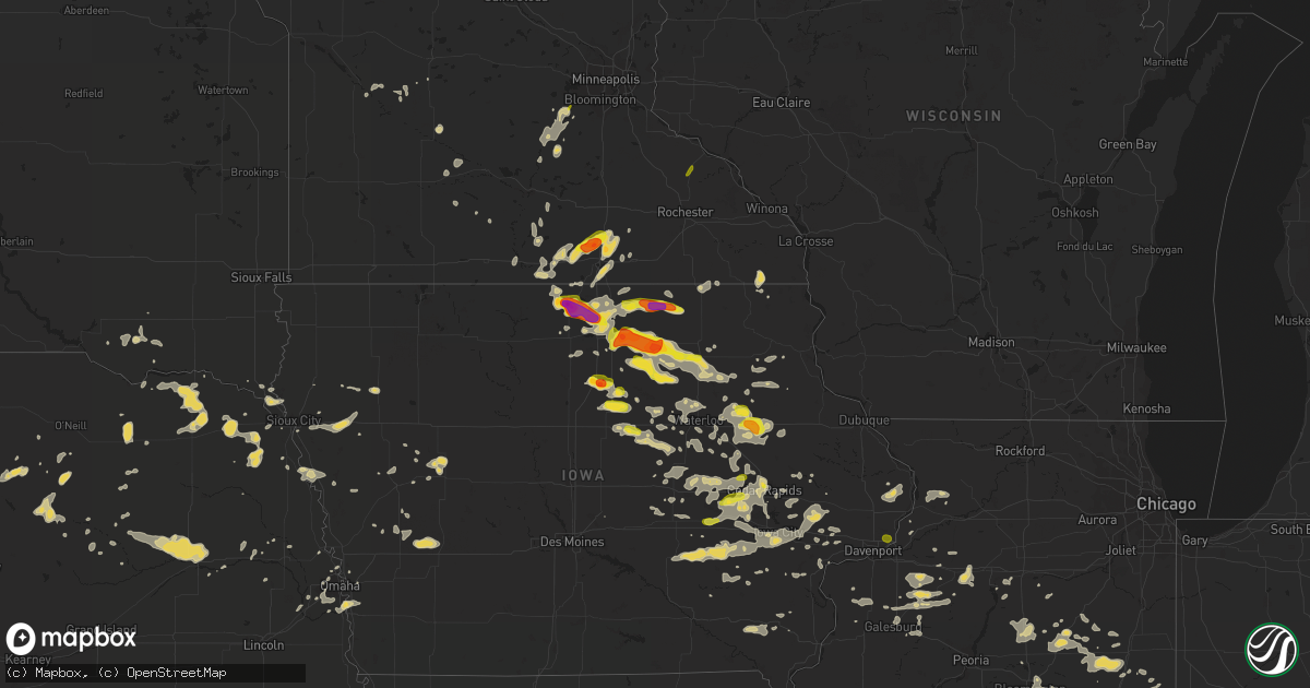
Hail Map on June 9, 2018
Get this storm
June 9 map
$229
one time, instant access
Download today. No call, no setup
Keep the $229
Bought the map and want the full workflow? Apply the entire $229 to a subscription within 7 days. None of it is wasted.
Every map, not just this one
This buys you this map. Subscription and you get every map we run, in the markets you choose from a few cities to whole states to nationwide. Plus real-time alerts the moment a storm fires.
Contact data
Name, contact info, occupancy, even credit band for addresses in the footprint. You go from where it hit to who to call.
Become the source they trust
Unlimited branding weather history reports on demand. You already have the documented answer ready for the property owner, and you are the one who showed up with it.
Property data and RoofTrace estimates
Pull up any address you have got, its value and the exact code rules for that jurisdiction, straight from One Click Code. Then RoofTrace estimates the squares, pitch, and roof value, priced the way you price.
States Impacted by Hail Map on June 9, 2018
Storm reports
Nebraska
| Date | Description |
|---|---|
| 06/09/201810:07 AM CDT | A local report indicates 70 MPH wind near 5 SSE CRESTON |
| 06/09/20187:55 AM CDT | At 1255 AM CDT, severe thunderstorms were located along a line extending from 6 miles northwest of Elgin to 8 miles west of Petersburg to Spalding to near North Loup, moving southeast at 45 mph. HAZARD...60 mph wind gusts. SOURCE...Radar indicated. IMPACT...Expect damage to roofs, siding, and trees. Locations impacted include... Albion, Battle Creek, Newman Grove, St. Edward, Elgin, Cedar Rapids, Petersburg, Oakdale, Meadow Grove, Lindsay, Tilden, Primrose, Cornlea, Loretto and The Highway 14 And 56 Junction. |
| 06/09/20187:39 AM CDT | At 1237 AM CDT, severe thunderstorms were located along a line extending from near Arnold to near Sargent, moving south at 45 mph. HAZARD...60 mph wind gusts. SOURCE...Radar indicated. IMPACT...Expect damage to roofs, siding, and trees. Locations impacted include... Broken Bow, Arnold, Callaway, Sargent, Ansley, Merna, Mason City, Oconto, Anselmo, Comstock, Berwyn, Victoria Springs State Recreation Area, Weissert, Westerville, Lillian, Walworth, Lodi, Buckeye, Finchville and Round Valley.This includes the following highways... Highway 183 between mile markers 73 and 121. Highway 2 between mile markers 253 and 307. Highway 92 between mile markers 248 and 308. |
| 06/09/20187:38 AM CDT | At 1238 AM CDT, a severe thunderstorm was located 11 miles northwest of Bartlett, or 26 miles northeast of Burwell, moving east at 35 mph. HAZARD...60 mph wind gusts and half dollar size hail. SOURCE...Radar indicated. IMPACT...Hail damage to vehicles is expected. Expect wind damage to roofs, siding, and trees. Locations impacted include... Burwell, Bartlett, Ericson, Knievels Corner, Cumminsville, Four Corners, Pibel Lake State Recreation Area, Buffalo Flats, Goose Lake State Wildlife Management Area and Gables.This includes Highway 281 between mile markers 132 and 160. |
| 06/09/20187:37 AM CDT | At 1236 AM CDT, severe thunderstorms were located along a line extending from 7 miles north of Spalding to near Ord to 6 miles southeast of Weissert, moving south at 45 mph. HAZARD...60 mph wind gusts along thunderstorm outflow SOURCE...Radar indicated. In addition, at 1231 AM CDT, the Ord airport measured a 64 MPH gust. IMPACT...Expect damage to roofs, siding, and trees. Locations impacted include... Ord, Greeley, Spalding, Scotia, Arcadia, North Loup, Elyria and Fort Hartsuff State Park. |
| 06/09/20185:50 AM CDT | At 1049 PM CDT, a severe thunderstorm was located just southwest of Kearney, moving east at 15 mph. HAZARD...60 mph wind gusts and quarter size hail. SOURCE...Radar indicated. IMPACT...Hail damage to vehicles is expected. Expect wind damage to roofs, siding, and trees. Locations impacted include... Mainly rural areas just south of Kearney. This includes Interstate 80 between mile markers 267 and 282. |
| 06/09/20183:05 AM CDT | At 805 PM CDT, a severe thunderstorm was located over Hamlin, moving southeast at 20 mph. HAZARD...60 mph wind gusts and nickel size hail. SOURCE...Radar indicated. IMPACT...Expect damage to roofs, siding, and trees. Locations impacted include... Hiawatha, Robinson, Reserve and Hamlin. |
| 06/09/20182:44 AM CDT | At 743 PM CDT, a severe thunderstorm was located near Morrill, moving southeast at 20 mph. HAZARD...60 mph wind gusts and quarter size hail. SOURCE...Radar indicated. IMPACT...Hail damage to vehicles is expected. Expect wind damage to roofs, siding, and trees. Locations impacted include... Hiawatha, Sabetha, Robinson, Morrill, Reserve and Hamlin. |
| 06/09/20182:09 AM CDT | At 708 PM CDT, a severe thunderstorm was located near Reserve, moving southeast at 20 mph. HAZARD...60 mph wind gusts and quarter size hail. SOURCE...Trained weather spotters reported 60 mph wind gusts in Falls City at 705 pm CDT. IMPACT...Hail damage to vehicles is expected. Expect wind damage to roofs, siding, and trees. Locations impacted include... Hiawatha, Robinson and Reserve. |
| 06/09/20181:41 AM CDT | At 641 PM CDT, a severe thunderstorm was located 5 miles east of Bern, moving east at 20 mph. HAZARD...60 mph wind gusts and quarter size hail. SOURCE...Radar indicated. IMPACT...Hail damage to vehicles is expected. Expect wind damage to roofs, siding, and trees. Locations impacted include... Sabetha, Morrill, Bern, Reserve and Hamlin. |
| 06/08/201811:15 PM CDT | At 415 AM CDT, severe thunderstorms were located along a line extending from 3 miles northwest of Minden to 9 miles northeast of Union, moving east at 40 mph. HAZARD...60 mph wind gusts. SOURCE...Radar indicated. IMPACT...Expect damage to roofs, siding, and trees. Locations impacted include... Red Oak, Glenwood, Shenandoah, Oakland, Avoca, Malvern, Treynor, Underwood, Carson, Essex, Walnut, Stanton, Shelby, Minden, Pacific Junction, Emerson, Elliott, Persia, Macedonia and Tabor.This includes the following highways... Interstate 29 between mile markers 20 and 29. Interstate 80 in Iowa between mile markers 14 and 48. |
| 06/08/201810:00 PM CDT | At 300 AM CDT, severe thunderstorms were located along a line extending from near Howells to near Brainard, moving east at 40 mph. HAZARD...60 mph wind gusts. SOURCE...Radar indicated. IMPACT...Expect damage to roofs, siding, and trees. Locations impacted include... Fremont, Wahoo, North Bend, Scribner, Hooper, Cedar Bluffs, Mead, Nickerson, Inglewood, Weston, Prague, Snyder, Uehling, Morse Bluff, Malmo, Colon, Winslow, Rogers, Linwood and Abie. |
| 06/08/20189:53 PM CDT | At 253 AM CDT, severe thunderstorms were located along a line extending from 4 miles west of Brainard to 5 miles east of Beaver Crossing to 3 miles northwest of Bruning, moving east at 40 mph. HAZARD...60 mph wind gusts. SOURCE...Radar indicated. IMPACT...Expect damage to roofs, siding, and trees. Locations impacted include... Lincoln, Seward, Crete, Milford, Wilber, Friend, Dorchester, Valparaiso, Beaver Crossing, Western, Garland, Pleasant Dale, Bee, Ceresco, Malcolm, Denton, Raymond, Daykin, Davey and Goehner.This includes Interstate 80 in Nebraska between mile markers 373 and405. |
| 06/08/20189:45 PM CDT | At 244 AM CDT, a severe thunderstorm was located 6 miles south of Stanton, or 16 miles southeast of Norfolk, moving east at 35 mph. HAZARD...60 mph wind gusts and quarter size hail. SOURCE...Radar indicated. IMPACT...Hail damage to vehicles is expected. Expect wind damage to roofs, siding, and trees. Locations impacted include... West Point, Stanton, Wisner, Beemer, The Highway 15 And 32 Junction, The Highway 9 And 51 Junction, 10 Miles West Of West Point and 8 Miles South Of Stanton. |
| 06/08/20189:38 PM CDT | At 237 AM CDT, severe thunderstorms were located along a line extending from 5 miles east of Platte Center to Shelby to near Henderson, moving east at 30 mph. HAZARD...60 mph wind gusts and quarter size hail. SOURCE...Radar indicated. IMPACT...Hail damage to vehicles is expected. Expect wind damage to roofs, siding, and trees. Locations impacted include... Columbus, Schuyler, David City, Utica, Bellwood, Beaver Crossing, Rising City, Brainard, Staplehurst, Dwight, Ulysses, Cordova, Octavia, Bruno, Richland, Garrison, Surprise, College View Trailer Park, Camp Pawnee and Shell Creek Elementary School.This includes Interstate 80 in Nebraska between mile markers 366 and371. |
| 06/08/20189:33 PM CDT | At 233 AM CDT, severe thunderstorms were located along a line extending from near Glenvil to near Campbell to 6 miles east of Oxford, moving southeast at 45 mph. HAZARD...60 mph wind gusts. SOURCE...Radar indicated. In addition, at 223 AM CDT, Hastings airport gusted to 62 MPH. IMPACT...Expect damage to roofs, siding, and trees. Locations impacted include... Alma, Franklin, Blue Hill, Oxford, Orleans, Hildreth, Wilcox, Campbell, Bladen, Roseland, Stamford, Republican City, Upland, Naponee, Bloomington, Ayr, Huntley, Ragan, Cowles and Rosemont. |
| 06/08/20189:31 PM CDT | At 230 AM CDT, severe thunderstorm outflow winds were located along a line extending from near Shelby to near Lushton to Glenvil, moving southeast at 60 mph. HAZARD...60 mph wind gusts. SOURCE...Radar indicated. In addition, at 223 AM CDT, Hastings airport gusted to 62 MPH. IMPACT...Expect damage to roofs, siding, and trees. Locations impacted include... York, Geneva, Sutton, Harvard, Henderson, Clay Center, Exeter, Fairmont, Edgar, McCool Junction, Fairfield, Shickley, Glenvil, Lawrence, Davenport, Milligan, Bruning, Bradshaw, Waco and Benedict.This includes Interstate 80 between mile markers 338 and 365. |
| 06/08/20189:13 PM CDT | At 213 AM CDT, a severe thunderstorm was located 6 miles southwest of Madison, or 19 miles south of Norfolk, moving east at 40 mph. HAZARD...60 mph wind gusts and quarter size hail. SOURCE...Radar indicated. IMPACT...Hail damage to vehicles is expected. Expect wind damage to roofs, siding, and trees. Locations impacted include... Madison, Clarkson, Leigh, Creston, Humphrey, Tarnov, Cornlea, Maple Creek Recreation Area, Camp Luther and 8 Miles South Of Stanton. |
| 06/08/20189:06 PM CDT | At 205 AM CDT, severe thunderstorm outflow winds were located along a line extending from near Kenesaw to 7 miles north of Minden to near Bertrand, moving south at 50 mph. HAZARD...60 mph wind gusts. SOURCE...Radar indicated. In addition, at 159 AM CDT, Kearney airport gusted to 59 MPH. IMPACT...Expect damage to roofs, siding, and trees. Locations impacted include... Kearney, Holdrege, Minden, Axtell, Loomis, Hildreth, Wilcox, Funk, Upland, Atlanta, Heartwell, Norman and Ragan.This includes Interstate 80 between mile markers 264 and 288. |
| 06/08/20189:04 PM CDT | At 204 AM CDT, a severe thunderstorm was located 4 miles southwest of Battle Creek, or 13 miles southwest of Norfolk, moving east at 25 mph. HAZARD...60 mph wind gusts. SOURCE...Radar indicated. IMPACT...Expect damage to roofs, siding, and trees. Locations impacted include... Norfolk, Battle Creek, Meadow Grove and Hadar. |
| 06/08/20188:59 PM CDT | At 158 AM CDT, severe thunderstorm outflow winds were located along a line extending from near Clarks to near Phillips to near Kenesaw, moving southeast at 60 mph. HAZARD...60 mph wind gusts or higher. SOURCE...Radar indicated. In addition, at 154 AM CDT, Grand Island airport gusted to 74 MPH. IMPACT...Expect damage to roofs, siding, and trees. Locations impacted include... Grand Island, Hastings, York, Aurora, Central City, Wood River, Harvard, Henderson, Kenesaw, Doniphan, Juniata, Alda, Hampton, Clarks, Giltner, Polk, Glenvil, Phillips, Chapman and Bradshaw.This includes Interstate 80 between mile markers 293 and 346. |
| 06/08/20188:47 PM CDT | At 147 AM CDT, a severe thunderstorm was located near Newman Grove, or 28 miles southwest of Norfolk, moving east at 40 mph. HAZARD...60 mph wind gusts. SOURCE...Radar indicated. IMPACT...Expect damage to roofs, siding, and trees. Locations impacted include... Madison, Newman Grove, Lindsay, Humphrey and Cornlea. |
| 06/08/20188:43 PM CDT | At 143 AM MDT, a severe thunderstorm was located about 3 miles northeast of Hyannis, or 31 miles west of Mullen, moving east at 30 mph. HAZARD...60 mph wind gusts and half dollar size hail. SOURCE...Radar indicated. IMPACT...Hail damage to vehicles is expected. Expect wind damage to roofs, siding, and trees. Locations impacted include... Whitman and Duluth. This includes the following highways... Highway 2 between mile markers 148 and 164. Highway 61 near mile marker 165. |
| 06/08/20188:29 PM CDT | At 129 AM MDT, a severe thunderstorm was located 12 miles east of Whitman, or 13 miles west of Mullen, moving east at 20 mph. HAZARD...60 mph wind gusts and quarter size hail. SOURCE...Radar indicated. IMPACT...Hail damage to vehicles is expected. Expect wind damage to roofs, siding, and trees. Locations impacted include... Mullen, Hecla and Weir. This includes the following highways... Highway 2 between mile markers 166 and 186. Highway 97 between mile markers 58 and 74. |
| 06/08/20188:00 PM CDT | At 1259 AM CDT, severe thunderstorm outflow winds were located along a line extending from near Spalding to near Sherman Reservoir Dam to near Oconto, moving south at 45 mph. HAZARD...60 mph wind gusts. SOURCE...Radar indicated. In addition, at 1231 AM CDT, the Ord airport gusted to 64 MPH. IMPACT...Expect damage to roofs, siding, and trees. Locations impacted include... Lexington, Ord, Cozad, Gothenburg, Greeley, St. Paul, Ravenna, Fullerton, Loup City, Spalding, Palmer, Pleasanton, Scotia, Arcadia, Dannebrog, North Loup, Wolbach, Litchfield, Sumner and Elba.This includes Interstate 80 between mile markers 209 and 231. |
| 06/08/20187:09 PM CDT | A local report indicates 68 MPH wind near 1 NNE FALLS CITY |
| 06/08/20187:00 PM CDT | Pea size hail. |
Washington
| Date | Description |
|---|---|
| 06/09/20186:00 PM CDT | The public reported some minor wind damage around a baseball field at harmony sports complex. 1 injury resulted. |
Texas
| Date | Description |
|---|---|
| 06/09/20183:00 PM CDT | Sheriff's office reporting numerous trees down off of gordy road |
| 06/09/20182:10 AM CDT | At 709 PM CDT, a severe thunderstorm was located over Saragosa, or 22 miles southeast of Toyah, moving northwest at 15 mph. HAZARD...60 mph wind gusts and half dollar size hail. SOURCE...Radar indicated. IMPACT...Hail damage to vehicles is expected. Expect wind damage to roofs, siding, and trees. Locations impacted include... Saragosa and Verhalen. This includes the following highways... Interstate 10 between mile markers 209 and 221. Interstate 20 between mile markers 9 and 11. |
| 06/08/20189:58 PM CDT | At 258 PM CDT, a severe thunderstorm was located over Pine Forest, or over Vidor, moving east at 5 mph. HAZARD...60 mph wind gusts and quarter size hail. SOURCE...Radar indicated. IMPACT...Hail damage to vehicles is expected. Expect wind damage to roofs, siding, and trees. Locations impacted include... Beaumont, Vidor, Rose City and Pine Forest. |
| 06/08/20189:56 PM CDT | At 255 PM CDT, a severe thunderstorm was located over Kemah Boardwalk, or over Seabrook, moving northeast at 15 mph. HAZARD...60 mph wind gusts. SOURCE...Radar indicated. IMPACT...Expect damage to roofs, siding, and trees. Locations impacted include... Southeastern Pasadena, northeastern League City, La Porte, Seabrook, Kemah, Nassau Bay, Taylor Lake Village, El Lago, Shoreacres, Clear Lake Shores, San Leon and Bacliff. |
Wisconsin
| Date | Description |
|---|---|
| 06/09/20185:36 AM CDT | At 1036 PM CDT, severe thunderstorms were located along a line extending from Greeley to Worthington to near Monticello, moving east at 35 mph. HAZARD...60 mph wind gusts and quarter size hail. SOURCE...Radar indicated. IMPACT...Hail damage to vehicles is expected. Expect wind damage to roofs, siding, and trees. Locations impacted include... Dubuque, Asbury, Dyersville, Cascade, Epworth, Farley, Peosta, Edgewood, Earlville, New Vienna, Colesburg, Worthington, Holy Cross, Greeley, Luxemburg, Rickardsville, Sherrill, Delaware, Centralia and Sageville. |
| 06/09/20182:28 AM CDT | At 728 PM CDT, severe thunderstorms were located along a line extending from 10 miles southwest of New Albin to 8 miles west of Lansing to near Waukon, moving east at 35 mph. HAZARD...60 mph wind gusts. SOURCE...Radar indicated. IMPACT...Expect damage to roofs, siding, and trees. Severe thunderstorms will be near... Lansing around 745 PM CDT. Harpers Ferry around 750 PM CDT. Other locations impacted by these severe thunderstorms includeHardin, Waterville, Hanover, County Roads A 52 And X 52 and Volney.This warning extends the previous warning. |
| 06/09/20182:02 AM CDT | At 702 PM CDT, severe thunderstorms were located along a line extending from near West Union to Fayette to near Fairbank, moving east at 20 mph. HAZARD...60 mph wind gusts. SOURCE...Radar indicated. IMPACT...Expect damage to roofs, siding, and trees. Severe thunderstorms will be near... Volga around 815 PM CDT. Elkader, Postville, Farmersburg, Monona and Strawberry Point around 830 PM CDT. Other locations impacted by these severe thunderstorms include Luana,North Buena Vista, St. Olaf, Garber and Osterdock. |
| 06/09/20181:45 AM CDT | At 645 PM CDT, severe thunderstorms were located along a line extending from near Ridgeway to near Calmar to near Ossian, moving northeast at 35 mph. HAZARD...60 mph wind gusts. SOURCE...Radar indicated. IMPACT...Expect damage to roofs, siding, and trees. Severe thunderstorms will be near... Postville around 700 PM CDT. Waukon around 720 PM CDT. Lansing around 730 PM CDT. Other locations impacted by these severe thunderstorms includeHardin, Waterville, Hanover, County Roads A 52 And X 52 and Volney. |
Kansas
| Date | Description |
|---|---|
| 06/09/20182:56 AM CDT | At 755 PM CDT, a severe thunderstorm was located near Troy, moving southeast at 30 mph. HAZARD...70 mph wind gusts and quarter size hail. SOURCE...Radar indicated. At 754 PM CDT a tree and powerpole were reported down in Oregon, MO. IMPACT...Hail damage to vehicles is expected. Expect considerable tree damage. Wind damage is also likely to mobile homes, roofs, and outbuildings. Locations impacted include... St. Joseph, Savannah, Wathena, Elwood, Highland, Troy, Country Club Villa, Country Club, Amazonia, Denton, Severance, Leona, St. Joseph Airport, Bendena and Fanning.This includes the following highways... Interstate 29 between mile markers 53 and 71. Interstate 229 between mile markers 7 and 14. |
| 06/09/20182:29 AM CDT | At 726 PM CDT, a severe thunderstorm was located 6 miles north of Sabetha, moving east at 20 mph. HAZARD...60 mph wind gusts and quarter size hail. SOURCE...Radar indicated. IMPACT...Hail damage to vehicles is expected. Expect wind damage to roofs, siding, and trees. Locations impacted include... Sabetha, Morrill and Hamlin. |
| 06/09/20181:49 AM CDT | At 649 PM CDT, a severe thunderstorm was located 7 miles northeast of Bern, or 9 miles north of Sabetha, moving east at 10 mph. HAZARD...60 mph wind gusts and quarter size hail. SOURCE...Radar indicated. IMPACT...Hail damage to vehicles is expected. Expect wind damage to roofs, siding, and trees. Locations impacted include... Falls City, Humboldt, Verdon, Stella, Shubert, Rulo, Dawson, Salem, Preston, Barada, The Highway 75 And 8 Junction and Camp Cornhusker. |
| 06/08/201810:03 PM CDT | At 302 AM CDT, severe thunderstorm outflow was located along a line extending from near Lawrence to Riverton to near Harlan County Dam, moving southeast at 30 mph. HAZARD...60 mph wind gusts. SOURCE...Radar indicated. In addition, at 242 AM CDT, an off duty NWS employee estimated 60 MPH winds two miles north of Pauline in Adams County. IMPACT...Expect damage to roofs, siding, and trees. Locations impacted include... Phillipsburg, Smith Center, Red Cloud, Franklin, Kensington, Agra, Guide Rock, Lebanon, Burr Oak, Republican City, Naponee, Bloomington, Esbon, Glade, Riverton, Athol, Cowles, Inavale, Bellaire and Harlan County Dam. |
| 06/08/201810:00 PM CDT | At 259 AM CDT, severe thunderstorm outflow winds were located along a line extending from near Lawrence to near Davenport to near Friend, moving south at 45 mph. HAZARD...60 mph wind gusts. SOURCE...Radar indicated. In addition, airports at Hastings, Aurora and York have all gusted to at least 59 MPH during the past hour. IMPACT...Expect damage to roofs, siding, and trees. Locations impacted include... Geneva, Superior, Hebron, Mankato, Deshler, Exeter, Edgar, Nelson, Shickley, Davenport, Milligan, Bruning, Chester, Alexandria, Hardy, Ruskin, Ohiowa, Carleton, Byron and Oak. |
| 06/08/20188:15 PM CDT | Estimated winds of 40 to 50 mph with gusts of 60 to 70 mph. Pea-sized hail. |
Illinois
| Date | Description |
|---|---|
| 06/09/201812:47 PM CDT | Delayed report from a spotter near cartter il. A 1-3 foot diameter tree in a neighbor's front yard was knocked down by the winds. Several tree limbs were also down in t |
| 06/09/201812:30 PM CDT | Tree knocked down a power pole. Delayed report. Time estimated from radar. |
| 06/09/201812:12 PM CDT | Gutters and siding damaged. |
| 06/09/201812:00 PM CDT | Report of a power pole down. |
| 06/09/201811:48 AM CDT | Large trees reported down around city. |
| 06/09/201811:45 AM CDT | Hail up to quarter size... Most was smaller. |
| 06/09/201811:36 AM CDT | Delayed report. Multiple tree limbs down. Partial tree fallen on a house. Some power lines also down. |
| 06/09/201811:36 AM CDT | A local report indicates 1.00 inch wind near 2 ESE COLUMBIA |
| 06/09/201811:27 AM CDT | A local report indicates 1.00 inch wind near 1 ESE EAST CARONDELET |
| 06/09/201811:20 AM CDT | Numerous trees reported down throughout city. |
| 06/09/201811:15 AM CDT | Corrects previous tstm wnd dmg report from 2 ese columbia. Delayed report. Multiple tree limbs down. Partial tree fallen on a house. Some power lines also down. |
| 06/09/20187:42 AM CDT | At 1242 PM CDT, a severe thunderstorm was located near Salem, moving southeast at 20 mph. HAZARD...60 mph wind gusts and quarter size hail. SOURCE...Radar indicated. IMPACT...Hail damage to vehicles is expected. Expect wind damage to roofs, siding, and trees. Locations impacted include... Salem, Helm, Iuka, Cartter and Selmaville. This includes Interstate 57 in Illinois near exit 116. |
| 06/09/20187:41 AM CDT | At 1240 PM CDT, a severe thunderstorm was located near Kilbourne, or 13 miles northeast of Virginia, moving east at 35 mph. HAZARD...60 mph wind gusts and nickel size hail. SOURCE...Radar indicated. IMPACT...Expect damage to roofs, siding, and trees. Locations impacted include... Springfield, Sherman, Petersburg, Athens, Ashland, Pleasant Plains, Greenview, Tallula, Kilbourne, Oakford, Cantrall, Newmansville, Atterberry, Salisbury, Lincolns New Salem and Sweetwater. |
| 06/09/20187:15 AM CDT | At 1215 PM CDT, a severe thunderstorm was located near Wamac, moving east at 25 mph. HAZARD...60 mph wind gusts and quarter size hail. SOURCE...Radar indicated. IMPACT...Hail damage to vehicles is expected. Expect wind damage to roofs, siding, and trees. Locations impacted include... Centralia, Sandoval, Wamac, Central City, Irvington, Ashley, Shattuc, Hoyleton, Hoffman, Junction City, Richview, Kell, New Minden, Walnut Hill and Huegely.This includes the following highways... Interstate 57 in Illinois near exit 109. Interstate 64 in Illinois near exit 61. |
| 06/09/20186:56 AM CDT | At 1156 AM CDT, a severe thunderstorm was located over Rushville, moving east at 25 mph. HAZARD...60 mph wind gusts and quarter size hail. SOURCE...Radar indicated. IMPACT...Hail damage to vehicles is expected. Expect wind damage to roofs, siding, and trees. Locations impacted include... Beardstown, Havana, Rushville, Virginia, Astoria, Bluff Springs, Vermont, Chandlerville, Bath, Browning, La Grange, Philadelphia, Frederick, Bluff City, Ray, Snicarte and Marbletown. |
| 06/09/20186:45 AM CDT | At 1145 AM CDT, a severe thunderstorm was located over Industry, or 11 miles south of Macomb, moving southeast at 30 mph. HAZARD...Quarter size hail. SOURCE...Radar indicated. IMPACT...Damage to vehicles is expected. Locations impacted include... Industry, Pennington Point and Doddsville. |
| 06/09/20186:34 AM CDT | At 1134 PM CDT, a severe thunderstorm was located near Bennett, or 10 miles east of Tipton, moving east at 45 mph. HAZARD...60 mph wind gusts. SOURCE...Radar indicated. IMPACT...Expect damage to roofs, siding, and trees. Locations impacted include... Davenport, Bettendorf, Clinton, Eldridge, DeWitt, Camanche, Le Claire, Princeton, Long Grove, Lowden, Wheatland, Cordova, Grand Mound, Calamus, Bennett, Donahue, McCausland, Low Moor, Dixon and Maysville.This includes the following highways... Interstate 74 in Iowa near mile marker 1. Interstate 80 in Iowa between mile markers 291 and 306. |
| 06/09/20185:32 AM CDT | At 1032 AM CDT, a severe thunderstorm was located near Assumption, or 7 miles east of Taylorville, moving southeast at 35 mph. HAZARD...60 mph wind gusts and quarter size hail. SOURCE...Radar indicated. IMPACT...Hail damage to vehicles is expected. Expect wind damage to roofs, siding, and trees. Locations impacted include... Taylorville, Shelbyville, Pana, Moweaqua, Assumption, Stewardson, Findlay, Cowden, Tower Hill, Westervelt, Strasburg, Clarksburg, Owaneco, Mode and Eagle Creek State Park. |
| 06/09/20183:24 AM CDT | Report of small limbs and leaf debris around county. Time estimated by radar. |
| 06/09/20182:48 AM CDT | Report of a tree down. Time estimated by radar. |
| 06/09/20182:42 AM CDT | Report of a tree down. Time estimated by radar. |
| 06/09/20182:39 AM CDT | Report of a tree down on route 29 south of sparland. Time estimated by radar. |
| 06/09/20182:21 AM CDT | Trees down across route 29. Time estimated by radar. |
| 06/09/20182:19 AM CDT | Reports of trees down... Along with numerous small limbs. Time estimated by radar. |
| 06/09/20182:08 AM CDT | Report of a tree down. Time estimated by radar. |
| 06/09/20182:05 AM CDT | Limb down on power line. Time estimated by radar. |
| 06/09/201812:51 AM CDT | Large tree limb down. Public report from social media. |
| 06/09/201812:38 AM CDT | Power lines down. Time estimated by radar. |
| 06/09/201812:02 AM CDT | At 502 AM CDT, a severe thunderstorm was located near Hooppole, or 14 miles south of Morrison, moving southeast at 40 mph. HAZARD...60 mph wind gusts and penny size hail. SOURCE...Radar indicated. IMPACT...Expect damage to roofs, siding, and trees. Locations impacted include... Princeton, Walnut, Wyanet, Atkinson, Sheffield, Annawan, Tampico, Buda, Hooppole, Deer Grove, Neponset, Yorktown, Malden, Manlius, Mineral, Dover, Hollowayville, New Bedford, Coal Hollow and Kasbeer.This includes the following highways... Interstate 80 in Illinois between mile markers 28 and 63. Interstate 88 near mile marker 38. Interstate 180 between mile markers 10 and 13. |
| 06/08/20189:24 PM CDT | At 224 PM CDT, a severe thunderstorm was located 9 miles west of Mount Vernon, moving east at 20 mph. HAZARD...60 mph wind gusts and penny size hail. SOURCE...Radar indicated. IMPACT...Expect damage to roofs, siding, and trees. Locations impacted include... Mount Vernon and Maunie. |
| 06/08/20189:14 PM CDT | At 214 PM CDT, a severe thunderstorm was located over Wickliffe, moving east at 20 mph. HAZARD...60 mph wind gusts and quarter size hail. SOURCE...Radar indicated. IMPACT...Hail damage to vehicles is expected. Expect wind damage to roofs, siding, and trees. Locations impacted include... Wickliffe, Barlow and Blandville. |
| 06/08/20189:06 PM CDT | At 205 AM CDT, a severe thunderstorm was located near German Valley, or 7 miles north of Mount Morris, moving east at 30 mph. HAZARD...Half dollar size hail. SOURCE...Radar indicated. IMPACT...Damage to vehicles is expected. This severe thunderstorm will be near, Byron around 220 AM CDT. Other locations impacted by this severe thunderstorm include Adelineand Leaf River. |
| 06/08/20188:13 PM CDT | At 113 PM CDT, a severe thunderstorm was located near Winchester, moving southeast at 25 mph. HAZARD...60 mph wind gusts and half dollar size hail. SOURCE...Radar indicated. IMPACT...Hail damage to vehicles is expected. Expect wind damage to roofs, siding, and trees. Locations impacted include... Winchester, Manchester, Alsey, Exeter and Glasgow. This includes Interstate 72 between mile markers 48 and 53. |
Iowa
| Date | Description |
|---|---|
| 06/09/20186:40 PM CDT | Small tree down |
| 06/09/20186:10 PM CDT | Via kwwl. |
| 06/09/20185:59 PM CDT | A local report indicates 65 MPH wind near 4 SW BOYD |
| 06/09/20185:59 PM CDT | A local report indicates 1.00 inch wind near 4 SW BOYD |
| 06/09/20185:38 PM CDT | Power out in charles city. |
| 06/09/20185:35 PM CDT | Awos station ccy... Charles city airport. |
| 06/09/20185:30 PM CDT | 60mph+ winds damage antenna and had large branches broke off at isu ag research farm. |
| 06/09/20185:29 PM CDT | A local report indicates 60 MPH wind near NASHUA |
| 06/09/20185:22 PM CDT | Power lines down across west-central floyd county. |
| 06/09/20185:18 PM CDT | A local report indicates 60 MPH wind near 2 S CHARLES CITY |
| 06/09/20185:03 PM CDT | A local report indicates 1.00 inch wind near 3 W CHARLES CITY |
| 06/09/20185:00 PM CDT | A local report indicates 80 MPH wind near 4 W FLOYD |
| 06/09/20184:55 PM CDT | A local report indicates 60 MPH wind near 3 W CHARLES CITY |
| 06/09/20184:55 PM CDT | Nickel to golf ball sized hail. |
| 06/09/20184:53 PM CDT | Hay racks blown across farm and through fence. Power out. Report via photo on social media. |
| 06/09/20184:50 PM CDT | Report via social media. |
| 06/09/20184:37 PM CDT | A local report indicates 70 MPH wind near 1 W RUDD |
| 06/09/20184:36 PM CDT | A local report indicates 75 MPH wind near ROCKFORD |
| 06/09/20184:32 PM CDT | A local report indicates 75 MPH wind near 2 W ROCKFORD |
| 06/09/20184:30 PM CDT | Trees and limbs down... Light pole down on outbuilding... And bleachers blown through fence at rockville high school baseball/softball complex. Time estimated from rada |
| 06/09/20184:30 PM CDT | Farm outbuilding destroyed with debris scattered through across street and through a field. Time estimated from radar. Report via photos on social media. |
| 06/09/20184:30 PM CDT | Numerous trees down. Time estimated from radar. Report via social media photos. |
| 06/09/20184:27 PM CDT | A local report indicates 1.75 inch wind near 2 S NORA SPRINGS |
| 06/09/20183:54 PM CDT | A local report indicates 71 MPH wind near 3 NE CLEAR LAKE |
| 06/09/20183:44 PM CDT | Via social media. |
| 06/09/20183:36 PM CDT | Via live streaming by severe studios. |
| 06/09/20183:11 PM CDT | Brief rope tornado reported by storm chaser who was 4 ene of forest city. |
| 06/09/20183:00 PM CDT | A local report indicates 2.00 inch wind near LELAND |
| 06/09/20182:55 PM CDT | A local report indicates 2.50 inch wind near 2 NNW LELAND |
| 06/09/20181:05 PM CDT | A local report indicates 1.00 inch wind near 4 N OSAGE |
| 06/09/20188:45 AM CDT | Mix of pea to quarter sized hail. |
| 06/09/20187:16 AM CDT | At 1216 AM CDT, a severe thunderstorm was located near Illinois City, or 12 miles east of Muscatine, moving northeast at 5 mph. HAZARD...60 mph wind gusts and half dollar size hail. SOURCE...Radar indicated. IMPACT...Hail damage to vehicles is expected. Expect wind damage to roofs, siding, and trees. Locations impacted include... Andalusia, Reynolds, Taylor Ridge, Illinois City, Edgington, Loud Thunder Forest Preserve and Loud Thunder Scout Camp. |
| 06/09/20186:16 AM CDT | At 1116 PM CDT, a severe thunderstorm was located over Stanwood, moving east at 40 mph. HAZARD...60 mph wind gusts. SOURCE...Radar indicated. IMPACT...Expect damage to roofs, siding, and trees. Locations impacted include... Mechanicsville, Stanwood, Lowden, Wheatland, Olin, Grand Mound, Delmar, Oxford Junction, Lost Nation, Calamus, Welton, Toronto, Clarence, Massillon Park, Oxford Mills, Big Rock, Elwood, Sherman Park and Walnut Grove Park. |
| 06/09/20185:56 AM CDT | At 1056 PM CDT, a severe thunderstorm was located near Millersburg, or 13 miles north of Sigourney, moving east at 35 mph. HAZARD...Quarter size hail. SOURCE...Radar indicated. IMPACT...Damage to vehicles is expected. Locations impacted include... Wellman, North English, Keswick, South English, Parnell, Millersburg, Kinross, Webster and Holbrook. |
| 06/09/20185:42 AM CDT | At 1041 PM CDT, severe thunderstorms were located along a line extending from near Prairieburg to Robins to near Atkins, moving east at 35 mph. HAZARD...60 mph wind gusts. SOURCE...Radar indicated. IMPACT...Expect damage to roofs, siding, and trees. Locations impacted include... Cedar Rapids, Anamosa, Marion, Hiawatha, Mount Vernon, Monticello, Robins, Center Point, Lisbon, Fairfax, Ely, Atkins, Central City, Springville, Palo, Shellsburg, Olin, Alburnett, Coggon and Wyoming.This includes Interstate 380 between mile markers 13 and 36. |
| 06/09/20184:45 AM CDT | At 944 PM CDT, severe thunderstorms were located along a line extending from near Hazleton to near Quasqueton to near Dysart, moving east at 40 mph. HAZARD...70 mph wind gusts and half dollar size hail. SOURCE...Radar indicated. IMPACT...Hail damage to vehicles is expected. Expect considerable tree damage. Wind damage is also likely to mobile homes, roofs, and outbuildings. Locations impacted include... Independence, Manchester, Dyersville, Monticello, Center Point, Urbana, Central City, Winthrop, Earlville, Walker, Alburnett, Coggon, Hopkinton, Quasqueton, Delhi, Ryan, Brandon, Rowley, Prairieburg and Dundee.This includes Interstate 380 between mile markers 36 and 55. |
| 06/09/20184:44 AM CDT | At 944 PM CDT, a severe thunderstorm was located over Ladora, or 8 miles southwest of Marengo, moving east at 30 mph. HAZARD...60 mph wind gusts and quarter size hail. SOURCE...Radar indicated. IMPACT...Hail damage to vehicles is expected. Expect wind damage to roofs, siding, and trees. Locations impacted include... Marengo, Williamsburg, Victor, Ladora, Amana, Conroy, Middle Amana, South Amana, Homestead, West Amana, Upper South Amana, East Amana, Genoa Bluff, High Amana and Iowa County Fairgrounds.This includes Interstate 80 in Iowa between mile markers 205 and 229. |
| 06/09/20184:20 AM CDT | At 919 PM CDT, severe thunderstorms were located along a line extending from Shellsburg to near Marengo, moving east at 25 mph. HAZARD...60 mph wind gusts and quarter size hail. SOURCE...Radar indicated. IMPACT...Hail damage to vehicles is expected. Expect wind damage to roofs, siding, and trees. Locations impacted include... Cedar Rapids, Vinton, Marion, Hiawatha, Mount Vernon, Robins, Center Point, Lisbon, Fairfax, Ely, Atkins, Walford, Central City, Springville, Palo, Shellsburg, Newhall, Blairstown, Van Horne and Alburnett.This includes Interstate 380 between mile markers 12 and 37. |
| 06/09/20184:13 AM CDT | At 913 PM CDT, a severe thunderstorm was located 8 miles northeast of Eldora, moving east at 25 mph. HAZARD...Quarter size hail. SOURCE...Radar indicated. IMPACT...Damage to vehicles is expected. Locations impacted include... Grundy Center, Wellsburg and Holland. |
| 06/09/20184:10 AM CDT | At 909 PM CDT, severe thunderstorms were located along a line extending from near Fairbank to near Jesup to 7 miles south of Crossroads Mall, moving southeast at 25 mph. HAZARD...60 mph wind gusts and quarter size hail. SOURCE...Radar indicated. IMPACT...Hail damage to vehicles is expected. Expect wind damage to roofs, siding, and trees. Locations impacted include... Independence, Jesup, Fairbank, Hazleton, Brandon, Rowley, Aurora, Stanley, Lime Creek County Park, Wapsipinicon Golf Course, Fontana County Park, Littleton, Buchanan County Fairgrounds, Otterville, Spencers Grove, Independence Airport, Jakway Park, Fontana Park, Cheney and Minne Estema Park.This includes Interstate 380 between mile markers 44 and 55. |
| 06/09/20183:51 AM CDT | At 851 PM CDT, severe thunderstorms were located along a line extending from near Denver to Waterloo to near Dike, moving southeast at 30 mph. HAZARD...60 mph wind gusts and quarter size hail. SOURCE...Radar indicated. IMPACT...Hail damage to vehicles is expected. Expect wind damage to roofs, siding, and trees. Locations impacted include... Waterloo, Cedar Falls, Evansdale, Jesup, La Porte City, Hudson, Dysart, Dike, Elk Run Heights, Crossroads Mall, Waterloo Municipal Airport, Uni-Dome And McLeod Center, Janesville, Washburn, Dunkerton, Raymond, Gilbertville and George Wyth State Park.This includes Interstate 380 between mile markers 56 and 73. |
| 06/09/20183:47 AM CDT | At 847 AM CDT, severe thunderstorms were located along a line extending from Center Point to near Marion to near Lake Macbride State Park, moving northeast at 10 mph. HAZARD...Quarter size hail. SOURCE...Trained weather spotters. IMPACT...Damage to vehicles is expected. Locations impacted include... Cedar Rapids, Marion, Hiawatha, Mount Vernon, Robins, Center Point, Lisbon, Solon, Ely, Central City, Springville, Palo, Swisher, Walker, Alburnett, Coggon, Shueyville, Bertram, Prairieburg and Toddville.This includes Interstate 380 between mile markers 8 and 39. |
| 06/09/20183:44 AM CDT | At 844 PM CDT, severe thunderstorms were located along a line extending from Lamont to near Winthrop to near Quasqueton, moving east at 20 mph. HAZARD...Ping pong ball size hail and 60 mph wind gusts. SOURCE...Radar indicated. IMPACT...People and animals outdoors will be injured. Expect hail damage to roofs, siding, windows, and vehicles. Expect wind damage to roofs, siding, and trees. Locations impacted include... Independence, Manchester, Edgewood, Winthrop, Earlville, Quasqueton, Lamont, Delhi, Colesburg, Ryan, Rowley, Greeley, Aurora, Dundee, Delaware, Masonville, Stanley, Oneida, Manchester Airport and Monti. |
| 06/09/20182:51 AM CDT | At 750 PM CDT, a severe thunderstorm was located near Jesup, or 11 miles northwest of Independence, moving east at 20 mph. HAZARD...60 mph wind gusts and quarter size hail. SOURCE...Radar indicated. IMPACT...Hail damage to vehicles is expected. Expect wind damage to roofs, siding, and trees. Locations impacted include... Independence, Jesup, Fairbank, Winthrop, Hazleton, Lamont, Aurora, Stanley, Winthrop Golf Course, Wapsipinicon Golf Course, Fontana County Park, Littleton, Buchanan County Fairgrounds, Otterville, Jakway Park and Fontana Park. |
| 06/09/20182:46 AM CDT | At 745 PM CDT, a severe thunderstorm was located near Iowa Falls, moving east at 25 mph. HAZARD...60 mph wind gusts and quarter size hail. SOURCE...Radar indicated. IMPACT...Hail damage to vehicles is expected. Expect wind damage to roofs, siding, and trees. Locations impacted include... Parkersburg, Ackley, Aplington and Bradford. |
| 06/09/20182:30 AM CDT | At 730 PM CDT, a severe thunderstorm was located near Denver, or 7 miles northeast of Waterloo, moving east at 25 mph. HAZARD...60 mph wind gusts and quarter size hail. SOURCE...Radar indicated. IMPACT...Hail damage to vehicles is expected. Expect wind damage to roofs, siding, and trees. Locations impacted include... Waterloo, Jesup and Dunkerton. |
| 06/09/20182:21 AM CDT | At 721 PM CDT, a severe thunderstorm was located near Hampton, moving east at 25 mph. HAZARD...60 mph wind gusts and half dollar size hail. SOURCE...Radar indicated. IMPACT...Hail damage to vehicles is expected. Expect wind damage to roofs, siding, and trees. Locations impacted include... Hampton, Allison, Dumont, Geneva, Bristow, Hansell and Allison Municipal Airport. |
| 06/09/20181:58 AM CDT | At 658 PM CDT, a severe thunderstorm was located 8 miles northwest of Hampton, moving east at 25 mph. HAZARD...Half dollar size hail. SOURCE...Radar indicated. IMPACT...Damage to vehicles is expected. Locations impacted include... Hampton, Sheffield, Latimer, Coulter, Hansell, Chapin, Hampton Municipal Airport and Beeds Lake State Park.This includes Interstate 35 between mile markers 164 and 175. |
| 06/09/20181:20 AM CDT | At 619 PM CDT, severe thunderstorms were located along a line extending from near Protivin to near Lawler to near Waucoma, moving northeast at 30 mph. HAZARD...60 mph wind gusts. SOURCE...Radar indicated. IMPACT...Expect damage to roofs, siding, and trees. Severe thunderstorms will be near... Fort Atkinson and Spillville around 635 PM CDT. Calmar around 640 PM CDT. Ossian around 655 PM CDT. Decorah around 700 PM CDT. Other locations impacted by these severe thunderstorms includeCastalia, Jackson Junction, State Road 9 And 245th Street, Festinaand Frankville. |
| 06/09/20181:09 AM CDT | At 608 PM CDT, a severe thunderstorm was located near Nashua, or 11 miles northwest of Waverly, moving southeast at 25 mph. HAZARD...60 mph wind gusts and quarter size hail. SOURCE...Radar indicated. IMPACT...Hail damage to vehicles is expected. Expect wind damage to roofs, siding, and trees. Locations impacted include... Waverly, Sumner, Denver, Tripoli, Janesville, Readlyn, Plainfield, Frederika and Waverly Municipal Airport. |
| 06/09/20181:07 AM CDT | At 606 PM CDT, a severe thunderstorm was located over Fredericksburg, or 8 miles southeast of New Hampton, moving east at 25 mph. Another cluster of storms was moving in from Bremer County as well. HAZARD...70 mph wind gusts. SOURCE...Emergency management. IMPACT...Expect considerable tree damage. Damage is likely to mobile homes, roofs, and outbuildings. This severe thunderstorm will be near... Waucoma around 625 PM CDT. Hawkeye around 640 PM CDT. West Union and Fayette around 655 PM CDT. Clermont around 715 PM CDT. Elgin around 720 PM CDT. Other locations impacted by this severe thunderstorm include Wadena,Westgate, St. Lucas, Randalia and Donnan. |
| 06/09/201812:58 AM CDT | At 557 PM CDT, a severe thunderstorm was located near New Hampton, moving east at 25 mph. Another severe thunderstorm was tracking across southern Floyd County, north of Greene Iowa. HAZARD...70 mph wind gusts. SOURCE...Radar indicated. IMPACT...Expect considerable tree damage. Damage is likely to mobile homes, roofs, and outbuildings. This severe thunderstorm will be near... Fredericksburg around 605 PM CDT. Lawler around 610 PM CDT. Other locations impacted by this severe thunderstorm includeChickasaw, North Washington, Bassett, Bradford and New HamptonAirport.People attending Heartland Days should seek safe shelter immediately!This warning extends the previous severe thunderstorm warning. |
| 06/09/201812:39 AM CDT | At 539 PM CDT, a severe thunderstorm was located near Greene, or 11 miles northwest of Allison, moving east at 20 mph. HAZARD...60 mph wind gusts and half dollar size hail. SOURCE...Radar indicated. IMPACT...Hail damage to vehicles is expected. Expect wind damage to roofs, siding, and trees. Locations impacted include... Clarksville and Greene. |
| 06/09/201812:10 AM CDT | Downed limb. |
| 06/08/201811:41 PM CDT | At 440 PM CDT, a severe thunderstorm was located over Floyd, or near Charles City, moving east at 35 mph. HAZARD...Golf ball size hail and 70 mph wind gusts. SOURCE...Trained weather spotters. IMPACT...People and animals outdoors will be injured. Expect hail damage to roofs, siding, windows, and vehicles. Expect considerable tree damage. Wind damage is also likely to mobile homes, roofs, and outbuildings. This severe thunderstorm will be near... Charles City around 445 PM CDT. Nashua around 500 PM CDT. Ionia around 505 PM CDT. New Hampton around 515 PM CDT. Jerico around 520 PM CDT. Fredericksburg around 525 PM CDT. Lawler and Protivin around 530 PM CDT. Other locations impacted by this severe thunderstorm includeChickasaw, Alta Vista, North Washington, Colwell and Bassett.People attending Heartland Days should seek safe shelter immediately!This warning extends the previous Severe Thunderstorm Warning for Floyd County. |
| 06/08/201811:28 PM CDT | At 427 AM CDT, severe thunderstorms were located along a line extending from near Argo Fay to near Donahue, moving southeast at 40 mph. HAZARD...60 mph wind gusts and nickel size hail. SOURCE...Radar indicated. IMPACT...Expect damage to roofs, siding, and trees. Locations impacted include... Davenport, Moline, Rock Island, Bettendorf, Clinton, East Moline, Sterling, Morrison, Silvis, Eldridge, DeWitt, Colona, Camanche, Le Claire, Coal Valley, Fulton, Savanna, Prophetstown, Hampton and Port Byron.This includes the following highways... Interstate 74 in Iowa between mile markers 1 and 5. Interstate 80 in Iowa between mile markers 292 and 306. Interstate 80 in Illinois between mile markers 1 and 12. Interstate 74 in Illinois between mile markers 1 and 15. Interstate 88 between mile markers 1 and 37. Interstate 280 between mile markers 17 and 18. |
| 06/08/201811:09 PM CDT | Multiple trees snapped off about halfway up along highway 13 north of manchester. Time estimated from radar. |
| 06/08/201810:57 PM CDT | At 356 PM CDT, a severe thunderstorm was located near Rockwell, or 7 miles south of Mason City, moving east at 20 mph. HAZARD...Half dollar size hail. SOURCE...Radar indicated. IMPACT...Damage to vehicles is expected. Locations impacted include... Mason City, Nora Springs, Rockwell, Mason City Municipal Airport, Clear Lake, Ventura, Plymouth, Fertile, Rock Falls, Burchinal, Portland and Clear Lake State Park.This includes Interstate 35 between mile markers 184 and 202. |
| 06/08/201810:51 PM CDT | At 350 PM CDT, a severe thunderstorm was located near Nora Springs, or 8 miles east of Mason City, moving east at 35 mph. HAZARD...Ping pong ball size hail and 60 mph wind gusts. SOURCE...Radar indicated. IMPACT...People and animals outdoors will be injured. Expect hail damage to roofs, siding, windows, and vehicles. Expect wind damage to roofs, siding, and trees. There have been tornado reports in north central Iowa earlier this afternoon from this same storm as well. This severe thunderstorm will be near... Rockford around 400 PM CDT. Rudd and Marble Rock around 405 PM CDT. Osage around 410 PM CDT. Charles City and Floyd around 420 PM CDT. Other locations impacted by this severe thunderstorm include Colwell,Orchard, County Roads B 60 And T 18, Rock Creek and Howards WoodRecreational Area. |
| 06/08/201810:46 PM CDT | Relayed by local broadcast media. |
| 06/08/201810:09 PM CDT | Multiple trees snapped off about halfway up along highway 13 north of manchester. Time estimated from radar. |
| 06/08/201810:00 PM CDT | A local report indicates 65 MPH wind near 2 SW MASONVILLE |
| 06/08/20189:52 PM CDT | At 251 PM CDT, a severe thunderstorm was located 7 miles north of Forest City, moving east at 15 mph. HAZARD...Quarter size hail. SOURCE...Radar indicated. IMPACT...Damage to vehicles is expected. Locations impacted include... Lake Mills, Rice Lake, Leland, Joice, Lake Mills Municipal Airport and Rice Lake State Park. |
| 06/08/20189:50 PM CDT | A local report indicates 60 MPH wind near WINTHROP |
| 06/08/20189:36 PM CDT | An ef-1 tornado touched down southeast of winthrop... Ia. A house was damaged. Garage door failed and roof came off in the wind. Some tree damage was also noted. The du |
| 06/08/20189:34 PM CDT | Relayed a report of thunderstorm wind damage in watkin. Tree limbs down. Time estimated using radar. |
| 06/08/20189:24 PM CDT | Relayed by benton county em. |
| 06/08/20189:20 PM CDT | Roof blown off of a home. Relayed by the em. Time estimated from radar. |
| 06/08/20189:20 PM CDT | Estimated wind gust of 70 mph and quarter hail.... |
| 06/08/20189:18 PM CDT | A local report indicates 1.00 inch wind near 1 NE INDEPENDENCE |
| 06/08/20189:02 PM CDT | A local report indicates 1.00 inch wind near 1 ESE INDEPENDENCE |
| 06/08/20188:35 PM CDT | Trees at about a 45 degree angle... No tree damage visibile. |
| 06/08/20188:10 PM CDT | At 110 PM CDT, a severe thunderstorm was located near Riceville, or 10 miles northeast of Osage, moving east at 15 mph. HAZARD...60 mph wind gusts and quarter size hail. SOURCE...Radar indicated. IMPACT...Hail damage to vehicles is expected. Expect wind damage to roofs, siding, and trees. This severe thunderstorm will be near... Riceville around 125 PM CDT. Elma around 140 PM CDT. Lime Springs around 215 PM CDT. Other locations impacted by this severe thunderstorm include Chester,Lylahs Marsh County Park, Saratoga, Davis Corners and County B 17 AndBell Avenue. |
| 06/08/20188:00 PM CDT | Mostly pea to nickel hail with a few to the size of quarters. |
| 06/08/20187:28 PM CDT | Nickle to quarter sized hail - via social media. |
| 06/08/20187:27 PM CDT | Large branches and power lines down |
| 06/08/20187:14 PM CDT | Trees down. Time estimated from radar. |
| 06/08/20187:14 PM CDT | Reports of power lines and branches down |
| 06/08/20187:11 PM CDT | A local report indicates 1.75 inch wind near 2 NE LATIMER |
| 06/08/20187:00 PM CDT | Trees and power lines down. Time estimate from radar. |
Missouri
| Date | Description |
|---|---|
| 06/09/20183:41 PM CDT | Late report. Localized wind damage to property. Large tree uprooted and fell on portion of home sustaining minor damage... Vehicle damaged as well. One side of house ha |
| 06/09/20182:35 PM CDT | Also penny size hail. |
| 06/09/201811:35 AM CDT | Tree blown on to house. |
| 06/09/201811:22 AM CDT | Tree blown on to house. Corrected time. |
| 06/09/201811:22 AM CDT | Large tree limbs blown down. One fell onto an unoccupied car damaging it on loran avenue. |
| 06/09/201811:15 AM CDT | Multiple tents and canopies blown over at church event. |
| 06/09/20187:49 AM CDT | At 1248 PM CDT, a severe thunderstorm was located near Hardin, moving east at 10 mph. HAZARD...60 mph wind gusts and quarter size hail. SOURCE...Radar indicated. IMPACT...Hail damage to vehicles is expected. Expect wind damage to roofs, siding, and trees. Locations impacted include... Hardin, Grafton, Old Kane, Kane, Fieldon, Batchtown, Otterville and Nutwood. |
| 06/09/20186:25 AM CDT | At 1125 AM CDT, a severe thunderstorm was located over Lemay, moving east at 15 mph. HAZARD...60 mph wind gusts and quarter size hail. SOURCE...Radar indicated. IMPACT...Hail damage to vehicles is expected. Expect wind damage to roofs, siding, and trees. Locations impacted include... St. Louis, Belleville, University City, East St. Louis, Webster Groves, Arnold, Fairview Heights, Clayton, Cahokia, Crestwood, Waterloo, Columbia, Richmond Heights, Sunset Hills, Brentwood, Maplewood, Shrewsbury, Centreville, Dupo and Millstadt.This also includes Scott Joplin Historic Site. |
| 06/09/20185:51 AM CDT | At 1050 AM CDT, a severe thunderstorm was located over Arnold, moving southeast at 30 mph. HAZARD...60 mph wind gusts and quarter size hail. SOURCE...Radar indicated. IMPACT...Hail damage to vehicles is expected. Expect wind damage to roofs, siding, and trees. Locations impacted include... Arnold, Waterloo, Columbia, Barnhart, Mehlville, Oakville, Antonia, Smithton, Green Park, Valmeyer, Fountain, New Design, Concord, Imperial, Sappington, Barr, Maeystown, Kimmswick, Madonnaville and Floraville.This includes Interstate 55 in Missouri between exits 185 and 191. This also includes Mastodon Historic Site. |
| 06/09/20183:43 AM CDT | At 843 PM CDT, a severe thunderstorm was located near Agency, or 8 miles west of Gower, moving southeast at 30 mph. HAZARD...70 mph wind gusts and penny size hail. SOURCE...Radar indicated. IMPACT...Expect considerable tree damage. Damage is likely to mobile homes, roofs, and outbuildings. Locations impacted include... Agency, Edgerton, Dearborn, Camden Point, De Kalb, Ridgely and Faucett.This includes Interstate 29 between mile markers 22 and 40. |
| 06/09/20183:12 AM CDT | At 812 PM CDT, a severe thunderstorm was located over Wathena, moving southeast at 30 mph. HAZARD...70 mph wind gusts and quarter size hail. SOURCE...Radar indicated. IMPACT...Hail damage to vehicles is expected. Expect considerable tree damage. Wind damage is also likely to mobile homes, roofs, and outbuildings. Locations impacted include... St. Joseph, Wathena, Elwood, Country Club Villa, Country Club, Agency, Easton, De Kalb, St. Joseph Airport and Faucett.This includes the following highways... Interstate 29 between mile markers 34 and 51. Interstate 229 between mile markers 0 and 12. |
| 06/09/20181:04 AM CDT | At 604 AM CDT, a severe thunderstorm was located 10 miles southeast of Salem, moving east at 15 mph. HAZARD...60 mph wind gusts and quarter size hail. SOURCE...Radar indicated. IMPACT...Hail damage to vehicles is expected. Expect wind damage to roofs, siding, and trees. Locations impacted include... Bunker... Turtle... Stone Hill... Howes Mill... Gladden... |
| 06/08/20189:21 PM CDT | At 221 PM CDT, a severe thunderstorm was located near Strafford, moving northeast at 10 mph. HAZARD...60 mph wind gusts and quarter size hail. SOURCE...Radar indicated. IMPACT...Hail damage to vehicles is expected. Expect wind damage to roofs, siding, and trees. Locations impacted include... Marshfield... Strafford... Northview... This includes Interstate 44 between mile markers 87 and 97. |
| 06/08/20188:25 PM CDT | Delayed report. Several gusts to 60 mph with 2-4 inch diameter tree limbs broken. |
| 06/08/20187:43 PM CDT | Tree and power line down. |
Delaware
| Date | Description |
|---|---|
| 06/09/20182:25 PM CDT | Spotter reports large tree limbs down |
| 06/09/20181:46 PM CDT | Large tree down on thomas street in seaford |
| 06/08/20189:24 PM CDT | At 223 PM EDT, a severe thunderstorm was located over Agner, or 10 miles north of Hurlock, moving east at 15 mph. HAZARD...60 mph wind gusts and quarter size hail. SOURCE...Radar indicated. IMPACT...Minor damage to vehicles is possible. Wind damage to roofs, siding, trees, and power lines is possible. Locations impacted include... Seaford, Denton, Bridgeville, Agner, Smithville, Andrewsville and Greenwood. |
Colorado
| Date | Description |
|---|---|
| 06/09/201812:17 AM CDT | At 517 PM MDT, a severe thunderstorm was located 10 miles southeast of Kim, or 38 miles southwest of Springfield, moving northeast at 15 mph. HAZARD...60 mph wind gusts and quarter size hail. SOURCE...Radar indicated. IMPACT...Hail damage to vehicles is expected. Expect wind damage to roofs, siding, and trees. This severe thunderstorm will remain over mainly rural areas of southwestern Baca and eastern Las Animas Counties. |
| 06/08/20189:20 PM CDT | At 219 PM MDT, a severe thunderstorm was located over Vilas, or 7 miles southeast of Springfield, moving east at 20 mph. HAZARD...60 mph wind gusts and quarter size hail. SOURCE...Radar indicated. IMPACT...Hail damage to vehicles is expected. Expect wind damage to roofs, siding, and trees. Locations impacted include... Vilas. |
Alabama
| Date | Description |
|---|---|
| 06/09/20186:50 PM CDT | Trees and power lines down near s shawdee road and nature trail road. |
| 06/09/20186:45 PM CDT | Multiple trees and power lines down on mountain gap road between chesterfield drive and brandywine drive; and near greenleaf circle and greenleaf drive intersection. |
| 06/09/20184:26 PM CDT | Multiple trees down in the county. |
| 06/09/20183:22 PM CDT | Tree down. |
| 06/09/20183:22 PM CDT | Tree down. |
| 06/09/20183:13 PM CDT | Tree down over the roadway near the corner of old shell rd near ridgelawn dr. E. Time estimated by radar. |
| 06/09/20183:07 PM CDT | Broadcast media relayed picture of roughly half dollar size hail at the corner of hillcrest and airport blvd. Time estimated from radar data |
| 06/09/20183:07 PM CDT | One inch hail reported at the university of south alabama from numerous pictures and video on social media. |
| 06/09/20182:55 PM CDT | Tree down. |
| 06/09/20182:41 PM CDT | Tree and powerline down. |
| 06/09/20184:16 AM CDT | At 915 PM CDT, a severe thunderstorm was located near Ohatchee, or 8 miles northwest of Saks, moving southeast at 15 mph. HAZARD...60 mph wind gusts. SOURCE...Radar indicated. IMPACT...Expect damage to roofs, siding, and trees. Locations impacted include... Anniston, Fort McClellan, Saks, West End-Cobb Town, Glencoe, Weaver, Ragland, Ohatchee, Blue Mountain, Alexandria, Neely Henry Lake, Southside, Neely Henry Dam, Sulphur Springs and Wellington. |
| 06/09/201812:09 AM CDT | At 509 PM CDT, a severe thunderstorm was located over Greenville, moving west at 5 to 10 mph. HAZARD...60 mph wind gusts and quarter size hail. SOURCE...Radar indicated. IMPACT...Hail damage to vehicles is expected. Expect wind damage to roofs, siding, and trees. Locations impacted include... Greenville. |
| 06/08/201811:22 PM CDT | At 422 PM CDT, a severe thunderstorm was located near New Brockton, or near Elba, and is nearly stationary. HAZARD...60 mph wind gusts and penny size hail. SOURCE...Radar indicated. IMPACT...Expect damage to roofs, siding, and trees. Locations impacted include... Elba, Enterprise, Fort Rucker, New Brockton, Kinston, Perry Store, Curtis, Carl Folsom A/p, Lucile, Ino, Turner Crossroads, Central City, Clintonville, Goodman, Camp Alaflo Bsa, Basin, Enterprise Municipal A/P, Woodland Grove Church, Alberton and Richburg. |
| 06/08/201810:59 PM CDT | At 358 PM CDT, a severe thunderstorm was located near Davisville, or 7 miles southeast of Tuskegee, and is nearly stationary. HAZARD...60 mph wind gusts and penny size hail. SOURCE...Radar indicated. IMPACT...Expect damage to roofs, siding, and trees. Locations impacted include... Tuskegee, Davisville, Warriorstand and Fort Davis. |
| 06/08/201810:53 PM CDT | At 353 PM CDT, a severe thunderstorm was located 11 miles south of Antioch, or 11 miles southwest of Brundidge, and is nearly stationary. HAZARD...60 mph wind gusts and penny size hail. SOURCE...Radar indicated. IMPACT...Expect damage to roofs, siding, and trees. Locations impacted include... Fort Rucker, Lee, Java, Chestnut Grove, Mixons Crossroads, Victoria, Frisco, Eanon, Lowry Mill, Wilkinstown, Camp Humming Hills, Wise Mill, Roeton, Clowers Crossroads, Arcus, Bluff Spring, Jack and Zoar. |
| 06/08/201810:44 PM CDT | At 344 PM CDT, a severe thunderstorm was located 5 miles south of Opp, moving northeast at 15 mph. HAZARD...60 mph wind gusts and quarter size hail. SOURCE...Radar indicated. IMPACT...Hail damage to vehicles is expected. Expect wind damage to roofs, siding, and trees. Locations impacted include... Opp. |
| 06/08/201810:09 PM CDT | At 308 PM CDT, a severe thunderstorm was located 7 miles east of Ozark, and is nearly stationary. HAZARD...60 mph wind gusts and penny size hail. SOURCE...Radar indicated. IMPACT...Expect damage to roofs, siding, and trees. Locations impacted include... Ozark, Fort Rucker, Newton, Pinckard, Bells Crossroads, Hunt Field, Waterford, Dill, Mabson, Snells Crossroads, Ewell, Dale County Lake, Marley Hill, Skipperville, Echo, Dean Church Road, Bagwells Crossroads, Kelly, Barefield Crossroads and Beamon. |
| 06/08/20189:50 PM CDT | At 250 PM CDT, a severe thunderstorm was located near Mobile Regional Airport, or 4 miles northwest of Tillmans Corner, moving southeast at 20 mph. HAZARD...60 mph wind gusts and nickel size hail. SOURCE...Radar indicated. IMPACT...Expect damage to roofs, siding, and trees. Locations impacted include... Midtown Mobile, Tillmans Corner, Tanner Williams and Mobile Regional Airport. |
| 06/08/20189:41 PM CDT | At 240 PM CDT, a severe thunderstorm was located near Abbeville, moving southeast at 10 mph. HAZARD...60 mph wind gusts and penny size hail. SOURCE...Radar indicated. IMPACT...Expect damage to roofs, siding, and trees. Locations impacted include... Abbeville, Headland, Newville, Bells Crossroads, Tumbleton, Echo, Kirkland Crossroads, Blackwood, Capps, Snells Crossroads, Barefield Crossroads, Murphy Station, Goldberg Field, Headland Municipal A/P, Dancey, Bertha and Balkum. |
| 06/08/20189:32 PM CDT | At 231 PM CDT, a severe thunderstorm was located over Semmes, or 8 miles west of Chickasaw, and is nearly stationary. HAZARD...60 mph wind gusts and nickel size hail. SOURCE...Radar indicated. IMPACT...Expect damage to roofs, siding, and trees. Locations impacted include... Semmes and Wilmer. |
| 06/08/20188:22 PM CDT | Several trees down on airport road near oneonta. |
| 06/08/20188:14 PM CDT | Trees down blocking tyler loop road in center point. |
| 06/08/20188:03 PM CDT | Trees and powerlines down on headrick road in bessemer. |
| 06/08/20188:03 PM CDT | Several trees down near hopewell road and nixon road in bessemer. |
| 06/08/20187:47 PM CDT | Several trees down on johns road. |
| 06/08/20187:14 PM CDT | Tree down on mobile home along bessemer superhighway. |
Maryland
| Date | Description |
|---|---|
| 06/09/20186:00 PM CDT | Tree down on hungerford road |
| 06/09/20182:11 PM CDT | Tree down at stinnett road and emmanuel church road. |
| 06/09/20182:07 PM CDT | Tree down at plum road and cox road. |
| 06/09/20181:58 PM CDT | Tree down at huntingtown road and stoneleigh court. |
| 06/09/20181:08 AM CDT | At 608 PM EDT, a severe thunderstorm was located over Clinton, moving southeast at 15 mph. HAZARD...60 mph wind gusts and quarter size hail. SOURCE...Radar indicated. IMPACT...Damaging winds will cause some trees and large branches to fall. This could injure those outdoors, as well as damage homes and vehicles. Roadways may become blocked by downed trees. Localized power outages are possible. Unsecured light objects may become projectiles. Locations impacted include... Waldorf, Clinton, Fort Washington, Camp Springs, Friendly, Saint Charles, Accokeek, Brandywine and Northwood. |
| 06/09/201812:46 AM CDT | At 546 PM EDT, a severe thunderstorm was located over Coral Hills, moving southeast at 10 mph. HAZARD...60 mph wind gusts and quarter size hail. SOURCE...Radar indicated. IMPACT...Damaging winds will cause some trees and large branches to fall. This could injure those outdoors, as well as damage homes and vehicles. Roadways may become blocked by downed trees. Localized power outages are possible. Unsecured light objects may become projectiles. Locations impacted include... Clinton, Forestville, Coral Hills, Upper Marlboro, Andrews Air Force Base, Camp Springs, Oxon Hill, Walker Mill, Rosaryville, Marlton, Temple Hills, Marlow Heights, Brandywine, District Heights, Capitol Heights, Morningside, Suitland-Silver Hill and Cheltenham. |
| 06/08/201810:53 PM CDT | At 351 PM EDT, a severe thunderstorm was located over Green Spring, or 10 miles southeast of Middletown, moving southeast at 15 mph. HAZARD...60 mph wind gusts and penny size hail. SOURCE...Radar indicated. IMPACT...Damage to roofs, siding, trees, and power lines is possible. Locations impacted include... Dover, Smyrna, Camden, Clayton, Cheswold, Millington, Sudlersville, Hartly, Rising Sun-Lebanon, Woodland Beach, Hazlettville, Morgnec, Delaney Corner, Dover Base Housing, Crumpton, Dover Speedway, Sassafras, Green Spring, Rising Sun and Massey. |
| 06/08/20189:48 PM CDT | At 248 PM EDT, a severe thunderstorm was located near Sycamore, or 9 miles southwest of Georgetown, moving east at 15 mph. HAZARD...60 mph wind gusts and quarter size hail. SOURCE...Radar indicated. IMPACT...Minor damage to vehicles is possible. Wind damage to roofs, siding, trees, and power lines is possible. This severe thunderstorm will be near... Sycamore around 300 PM EDT. Georgetown around 315 PM EDT. Millsboro and Dagsboro around 330 PM EDT.Other locations impacted by this severe thunderstorm includeFrankford, Blades and Bethel. |
| 06/08/20189:12 PM CDT | At 212 PM EDT, a severe thunderstorm was located over Marlton, or over Upper Marlboro, moving east at 5 mph. HAZARD...60 mph wind gusts and quarter size hail. SOURCE...Radar indicated. IMPACT...Damaging winds will cause some trees and large branches to fall. This could injure those outdoors, as well as damage homes and vehicles. Roadways may become blocked by downed trees. Localized power outages are possible. Unsecured light objects may become projectiles. Locations impacted include... Clinton, Forestville, Largo, Upper Marlboro, Andrews Air Force Base, Camp Springs, Kettering, Walker Mill, Rosaryville, Marlton, Dunkirk, Brandywine, District Heights, Baden, Morningside and Cheltenham. |
| 06/08/20188:21 PM CDT | At 120 PM EDT, a severe thunderstorm was located over Hazlettville, or near Dover, moving east at 25 mph. HAZARD...60 mph wind gusts and half dollar size hail. SOURCE...Radar indicated. IMPACT...Minor damage to vehicles is possible. Wind damage to roofs, siding, trees, and power lines is possible. Locations impacted include... Dover, Camden, Cheswold, Bowers, Goldsboro, Woodside, Viola, Hartly, Rising Sun-Lebanon, Hazlettville, Dover Base Housing, Dover Speedway, Sandtown, Rising Sun, Wyoming, Felton, Frederica, Magnolia, Little Creek and Henderson. |
New Mexico
| Date | Description |
|---|---|
| 06/09/20187:24 AM CDT | At 1224 AM MDT, a severe thunderstorm was located over Conchas Lake State Park, or 31 miles northwest of Tucumcari, and is nearly stationary. HAZARD...60 mph wind gusts and quarter size hail. SOURCE...Radar indicated. IMPACT...Hail damage to vehicles is expected. Expect wind damage to roofs, siding, and trees. Locations impacted include... Conchas Dam, Conchas and Conchas Lake State Park. |
| 06/09/20187:15 AM CDT | At 1214 AM MDT, a severe thunderstorm was located 9 miles northwest of Melrose, or 28 miles east of Fort Sumner, moving southeast at 10 mph. HAZARD...60 mph wind gusts and half dollar size hail. SOURCE...Radar indicated. IMPACT...Hail damage to vehicles is expected. Expect wind damage to roofs, siding, and trees. Locations impacted include... Melrose. |
| 06/09/20184:54 AM CDT | At 954 PM CDT/854 PM MDT/, a severe thunderstorm was located near Red Bluff Reservoir, or 21 miles northwest of Mentone, moving northeast at 15 mph. HAZARD...60 mph wind gusts and half dollar size hail. SOURCE...Radar indicated. IMPACT...Hail damage to vehicles is expected. Expect wind damage to roofs, siding, and trees. Locations impacted include... Red Bluff Reservoir and Red Bluff. |
| 06/09/201812:25 AM CDT | At 525 PM MDT, a severe thunderstorm was located 7 miles east of Mosquero, moving east at 30 mph. HAZARD...60 mph wind gusts and half dollar size hail. SOURCE...Radar indicated. IMPACT...Hail damage to vehicles is expected. Expect wind damage to roofs, siding, and trees. Locations impacted include... Mosquero. |
| 06/08/201811:40 PM CDT | At 440 PM MDT, a severe thunderstorm was located 15 miles southwest of Solano, or 17 miles southwest of Mosquero, moving southeast at 30 mph. HAZARD...Ping pong ball size hail and 60 mph wind gusts. SOURCE...Radar indicated. IMPACT...People and animals outdoors will be injured. Expect hail damage to roofs, siding, windows, and vehicles. Expect wind damage to roofs, siding, and trees. Locations impacted include... Bell Ranch. |
| 06/08/20189:18 PM CDT | At 217 AM MDT, a severe thunderstorm was located near Montoya, or 21 miles west of Tucumcari, moving southeast at 10 mph. HAZARD...60 mph wind gusts and quarter size hail. SOURCE...Radar indicated. IMPACT...Hail damage to vehicles is expected. Expect wind damage to roofs, siding, and trees. Locations impacted include... Montoya.This includes Interstate 40 between Mile Markers 303 and 325. |
| 06/08/20188:16 PM CDT | At 115 AM MDT, a severe thunderstorm was located 9 miles west of Tucumcari, moving east at 10 mph. HAZARD...60 mph wind gusts and half dollar size hail. SOURCE...Radar indicated. IMPACT...Hail damage to vehicles is expected. Expect wind damage to roofs, siding, and trees. Locations impacted include... Tucumcari.This includes Interstate 40 between Mile Markers 318 and 337. |
Virginia
| Date | Description |
|---|---|
| 06/09/20186:38 PM CDT | Tree down along the 6800 block of wilson road. |
| 06/09/20186:14 PM CDT | Tree down on entrence ramp to 501 northbound from fort avenue. |
| 06/09/20186:05 PM CDT | Tree down over landover pl. Time radar estimated. |
| 06/09/20185:54 PM CDT | Tree down in the blue ridge farms neighborhood. Time radar estimated. |
| 06/09/20185:48 PM CDT | Tree down on john scott drive. Time radar estimated. |
| 06/09/20185:46 PM CDT | Tree down at 5000 block of longmeadow road. |
| 06/09/20185:30 PM CDT | Large limbs snapped out of trees. |
| 06/09/20185:27 PM CDT | Tree down on the 100 block of bufflo trail. |
| 06/09/20185:13 PM CDT | Tree down on 700 block of smithfield road. |
| 06/09/20185:02 PM CDT | Tree down along tye river road. |
| 06/09/20184:55 PM CDT | Tree down along the 400 block of marple road. |
| 06/09/20184:54 PM CDT | A few trees down around amherst. One closed road briefly at east monitor road and lexington turnpike. Time radar estimated. |
| 06/09/20183:14 PM CDT | Trees down across southeastern augusta county |
| 06/09/20182:16 AM CDT | At 716 PM EDT, a severe thunderstorm was located over Delaplane, or 14 miles east of Front Royal, moving southeast at 20 mph. HAZARD...60 mph wind gusts and quarter size hail. SOURCE...Radar indicated. IMPACT...Damaging winds will cause some trees and large branches to fall. This could injure those outdoors, as well as damage homes and vehicles. Roadways may become blocked by downed trees. Localized power outages are possible. Unsecured light objects may become projectiles. Locations impacted include... Middleburg, The Plains, Delaplane, Marshall, Upperville, Halfway, Ashville, Rectortown, Paris and Ada. |
| 06/09/20181:53 AM CDT | At 653 PM EDT, a severe thunderstorm was located over Front Royal, moving southeast at 20 mph. HAZARD...60 mph wind gusts and quarter size hail. SOURCE...Radar indicated. IMPACT...Damaging winds will cause some trees and large branches to fall. This could injure those outdoors, as well as damage homes and vehicles. Roadways may become blocked by downed trees. Localized power outages are possible. Unsecured light objects may become projectiles. Locations impacted include... Front Royal, Hume, Linden, Marshall, Chester Gap, Flint Hill, Washington, Huntly, Arco, Howellsville, Riverton, Cresthill, Karo, Glen Echo, Blue Mountain, Nineveh, Markham, Cedarville, Ashville and Ada. |
| 06/09/20181:53 AM CDT | At 652 PM EDT, a severe thunderstorm was located over Sharps, or near Robley, moving southeast at 20 mph. HAZARD...60 mph wind gusts and quarter size hail. SOURCE...Radar indicated. IMPACT...Minor damage to vehicles is possible. Expect wind damage to trees and powerlines. This severe thunderstorm will be near, Robley around 705 PM EDT. Morattico around 710 PM EDT. Jamaica around 715 PM EDT. Church View around 725 PM EDT. Lancaster around 730 PM EDT.Other locations impacted by this severe thunderstorm includeLaneview, Nesting, Somers, Mollusk, Alfonso, Bowlers Wharf,Nuttsville, Belle Isle State Park, Montague and Downing. |
| 06/09/20181:34 AM CDT | At 634 PM EDT, a severe thunderstorm was located over Fort Hunt, moving southeast at 10 mph. HAZARD...60 mph wind gusts and quarter size hail. SOURCE...Radar indicated. IMPACT...Damaging winds will cause some trees and large branches to fall. This could injure those outdoors, as well as damage homes and vehicles. Roadways may become blocked by downed trees. Localized power outages are possible. Unsecured light objects may become projectiles. Locations impacted include... Waldorf, Fort Washington, Fort Hunt, La Plata, Fort Belvoir, Hybla Valley, Saint Charles, Mount Vernon, Accokeek, Bryans Road, Mason Neck, Potomac Heights, Pomfret, Tantallon, Marbury, White Plains, Rison and Pisgah. |
| 06/09/20181:12 AM CDT | At 612 PM EDT, a severe thunderstorm was located over Falconerville, moving southeast at 15 mph. HAZARD...60 mph wind gusts and quarter size hail. SOURCE...Radar indicated. IMPACT...Hail damage to vehicles is expected. Expect wind damage to roofs, siding, and trees. Locations impacted include... Lynchburg... Amherst... Concord... Rustburg... and Madison Heights.This includes The following Locations Liberty University andLynchburg Airport. |
| 06/09/201812:42 AM CDT | At 542 PM EDT, a severe thunderstorm was located near Bent Creek, and is nearly stationary. HAZARD...Ping pong ball size hail and 60 mph wind gusts. SOURCE...Radar indicated. IMPACT...Damaging winds will cause some trees and large branches to fall. This could injure those outdoors, as well as damage homes and vehicles. Roadways may become blocked by downed trees. Localized power outages are possible. Unsecured light objects may become projectiles. Locations impacted include... Shipman, Arrington, Norwood, Five Forks, Tye River, Allens Creek, Gladstone, Buffalo Springs and Wingina. |
| 06/09/201812:41 AM CDT | At 541 PM EDT, a severe thunderstorm was located near Bent Creek, moving south at 10 mph. HAZARD...60 mph wind gusts and quarter size hail. SOURCE...Radar indicated. IMPACT...Hail damage to vehicles is expected. Expect wind damage to roofs, siding, and trees. Locations impacted include... Buckingham... Bent Creek... Toga... Sheppards... and Andersonville. |
| 06/09/201812:28 AM CDT | At 527 PM EDT, a severe thunderstorm was located near Romney, moving southeast at 15 mph. HAZARD...60 mph wind gusts and quarter size hail. SOURCE...Radar indicated. IMPACT...Damaging winds will cause some trees and large branches to fall. This could injure those outdoors, as well as damage homes and vehicles. Roadways may become blocked by downed trees. Localized power outages are possible. Unsecured light objects may become projectiles. Locations impacted include... Capon Bridge, Augusta, Yellow Spring, High View, Shanks, Wilde Acres, Frenchburg, Slanesville, Rock Enon Springs, Gore, Capon Springs, Timber Ridge, Lehew and Gainesboro. |
| 06/09/201812:19 AM CDT | At 519 PM EDT, a severe thunderstorm was located near Greenwood, moving southeast at 25 mph. HAZARD...60 mph wind gusts and quarter size hail. SOURCE...Radar indicated. IMPACT...Damaging winds will cause some trees and large branches to fall. This could injure those outdoors, as well as damage homes and vehicles. Roadways may become blocked by downed trees. Localized power outages are possible. Unsecured light objects may become projectiles. Locations impacted include... Greenwood, Inwood, Cedar Grove, Clear Brook, Ridgeway, Fishers Bridge, Bunker Hill, Oakland, Rock Gap, Bloomery, Stephenson, Cross Junction, Arden, Cedar Hill, Unger, Brucetown, Glengary, Omps, Shanghai and Gerrardstown. |
| 06/09/201812:15 AM CDT | At 515 PM EDT, a severe thunderstorm was located near New Castle, moving southeast at 15 mph. HAZARD...60 mph wind gusts and quarter size hail. SOURCE...Radar indicated. IMPACT...Hail damage to vehicles is expected. Expect wind damage to roofs, siding, and trees. Locations impacted include... Roanoke... Vinton... Troutville... New Castle... and Stewartsville.This includes The following Location Roanoke Regional Airport. |
| 06/08/201811:58 PM CDT | At 458 PM EDT, a severe thunderstorm was located near Montebello, moving south at 15 mph. HAZARD...60 mph wind gusts and quarter size hail. SOURCE...Radar indicated. IMPACT...Hail damage to vehicles is expected. Expect wind damage to roofs, siding, and trees. Locations impacted include... Amherst... Forks Of Buffalo... Clifford... Falconerville... and Riverville. |
| 06/08/201811:09 PM CDT | At 409 PM EDT, a severe thunderstorm was located near Stuarts Draft, or 10 miles south of Staunton, moving southeast at 20 mph. HAZARD...60 mph wind gusts and quarter size hail. SOURCE...Radar indicated. IMPACT...Damaging winds will cause some trees and large branches to fall. This could injure those outdoors, as well as damage homes and vehicles. Roadways may become blocked by downed trees. Localized power outages are possible. Unsecured light objects may become projectiles. Locations impacted include... Stuarts Draft, Sherando, Wintergreen, Montebello, Lyndhurst, Nellysford, Greenville, Greenfield, Mint Spring, Tyro and Spottswood. |
| 06/08/20187:05 PM CDT | Tree down along the 6800 block of wilson road. |
Tennessee
| Date | Description |
|---|---|
| 06/09/20186:26 AM CDT | At 1126 PM EDT, a severe thunderstorm was located 8 miles southeast of Parrottsville, or 11 miles east of Newport, moving southeast at 10 mph. HAZARD...60 mph wind gusts and quarter size hail. SOURCE...Radar indicated. IMPACT...Hail damage to vehicles is expected. Expect wind damage to roofs, siding, and trees. Locations impacted include... Newport, Parrottsville, Caney Branch, Round Mountain, Del Rio and Cedar Creek. |
| 06/08/201810:15 PM CDT | Winds blew down a metal building |
Montana
| Date | Description |
|---|---|
| 06/09/20186:45 PM CDT | A local report indicates 1.00 inch wind near 10 W BROADUS |
| 06/09/20186:40 PM CDT | A local report indicates 1.50 inch wind near 13 W BROADUS |
| 06/09/20185:30 PM CDT | A local report indicates 62 MPH wind near 6 NNW SUNBURST |
| 06/09/20184:07 PM CDT | A local report indicates 1.00 inch wind near SKALKAHO PASS |
| 06/09/20185:47 AM CDT | At 1046 PM MDT, a severe thunderstorm was located 21 miles southwest of Fort Belknap, or 24 miles south of Chinook, moving north at 35 mph. HAZARD...60 mph wind gusts and half dollar size hail. SOURCE...Radar indicated. IMPACT...Hail damage to vehicles is expected. Expect wind damage to roofs, siding, and trees. Locations impacted include... Harlem, Cleveland and Zurich. |
| 06/09/20183:15 AM CDT | At 815 PM MDT, a severe thunderstorm was located 13 miles north of Colony, or 28 miles north of Belle Fourche, moving northeast at 40 mph. HAZARD...60 mph wind gusts and quarter size hail. SOURCE...Radar indicated. IMPACT...Hail damage to vehicles is expected. Expect wind damage to roofs, siding, and trees. This severe thunderstorm will remain over mainly rural areas of southeastern Carter County. |
| 06/09/20182:47 AM CDT | At 746 PM MDT, a severe thunderstorm was located over Harding, or 21 miles southwest of Buffalo, moving northeast at 45 mph. HAZARD...60 mph wind gusts and penny size hail. SOURCE...Radar indicated. IMPACT...Expect damage to roofs, siding, and trees. Locations impacted include... Buffalo, Harding, Ludlow, Reva, Gustave, Redig, East Short Pines, West Short Pines, Slim Buttes, South Cave Hills, Sheep Buttes, Lake Gardner, Crow Buttes and North Cave Hills. |
| 06/09/20182:30 AM CDT | At 730 PM MDT, a severe thunderstorm was located 10 miles south of Denton, or 11 miles east of Stanford, moving northeast at 15 mph. HAZARD...60 mph wind gusts and quarter size hail. SOURCE...Radar indicated. IMPACT...Hail damage to vehicles is expected. Expect wind damage to roofs, siding, and trees. Locations impacted include... Denton and Danvers. |
| 06/09/20181:35 AM CDT | At 634 PM MDT, severe thunderstorms were located along a line extending from 8 miles south of Highwood to 18 miles southwest of Hobson, moving north at 40 mph. HAZARD...70 mph wind gusts. SOURCE...Radar indicated. IMPACT...Expect considerable tree damage. Damage is likely to mobile homes, roofs, and outbuildings. Locations impacted include... Fort Benton, Stanford, Geraldine, Denton, Geyser, Highwood, Windham, Moccasin, Sapphire Village, Utica, Shonkin, Loma, Coffee Creek, Square Butte and Benchland. |
| 06/09/201812:27 AM CDT | At 527 PM MDT, a severe thunderstorm was located 11 miles west of Broadus, moving northeast at 15 mph. HAZARD...60 mph wind gusts and quarter size hail. SOURCE...Radar indicated. IMPACT...Hail damage to vehicles is expected. Expect wind damage to roofs, siding, and trees. Locations impacted include... Broadus and Olive. |
| 06/08/201810:27 PM CDT | At 326 PM MDT, a severe thunderstorm was located 7 miles west of Drummond, moving northeast at 40 mph. HAZARD...60 mph wind gusts and quarter size hail. SOURCE...Radar indicated. IMPACT...Hail damage to vehicles is expected. Expect wind damage to roofs, siding, and trees. Locations impacted include... Drummond, Jens, Hall, New Chicago, Bearmouth and Maxville. |
| 06/08/20189:37 PM CDT | At 237 PM MDT, a severe thunderstorm was located 24 miles south of Heart Butte, or 35 miles west of Choteau, moving northeast at 30 mph. HAZARD...60 mph wind gusts and quarter size hail. SOURCE...Radar indicated. IMPACT...Hail damage to vehicles is expected. Expect wind damage to roofs, siding, and trees. Locations impacted include... Heart Butte and Dupuyer. |
| 06/08/20188:20 PM CDT | A local report indicates 1.50 inch wind near 2 NW BENCHLAND |
Georgia
| Date | Description |
|---|---|
| 06/09/20186:07 PM CDT | Picture via twitter of a tree down over a roadway over powerlines. |
| 06/09/20186:00 PM CDT | A large gust of wind knocked down sveral trees in the area of five forks trickum rd between lawrenceville and snellville. |
| 06/09/20185:47 PM CDT | Report of several trees leaning over roadway via twitter |
| 06/09/20185:30 PM CDT | Alma-bacon county emergency management reported numerous... At least 20... Large trees and power line poles... At least 6... Down across roads in the northwest and west |
| 06/09/20183:00 PM CDT | Tree down along hwy 308... North of smithville. |
| 06/09/201812:57 PM CDT | Multiple trees down and .25 inch hail reported. |
| 06/09/201812:56 PM CDT | Two trees down in oakland. |
| 06/09/20181:12 AM CDT | At 612 PM EDT, a severe thunderstorm was located over Alma, moving south at 5 mph. HAZARD...60 mph wind gusts and nickel size hail. SOURCE...Radar indicated. IMPACT...Expect damage to roofs, siding, and trees. Locations impacted include... Alma and New Lacy. |
| 06/08/201811:19 PM CDT | At 419 PM EDT, a severe thunderstorm was located over Fortson, or 8 miles northeast of Columbus, and is nearly stationary. HAZARD...60 mph wind gusts and quarter size hail. SOURCE...Radar indicated. IMPACT...Hail damage to vehicles is expected. Expect wind damage to roofs, siding, and trees. Locations impacted include... Saint Marys Hills, Edgewood, Flat Rock, Highland Park, Laurel Hills, Kenwood, Midland, Vista Terrace and Columbus Metropolitan Airport. |
| 06/08/201810:33 PM CDT | At 333 PM EDT, a severe thunderstorm was located over Lumpkin, and is nearly stationary. HAZARD...60 mph wind gusts and quarter size hail. SOURCE...Radar indicated. IMPACT...Hail damage to vehicles is expected. Expect wind damage to roofs, siding, and trees. Locations impacted include... Lumpkin, Troutman, Westville and Providence Canyon State Park. |
| 06/08/201810:27 PM CDT | At 326 PM EDT/226 PM CDT/, a severe thunderstorm was located 7 miles southeast of Abbeville, moving north at 10 mph. HAZARD...60 mph wind gusts and penny size hail. SOURCE...Radar indicated. IMPACT...Expect damage to roofs, siding, and trees. Locations impacted include... Abbeville, Fort Gaines, Haleburg, Shorterville, Walter F. George Lock And Dam, Walter F George Lake, Barnes, Hardwickburg, Hayes, Murphy Station, Graball, Miller, Abbeville Municipal A/P, Willis Crossroads, Fort Gaines-Clay Airport and Balkum. |
| 06/08/201810:01 PM CDT | At 300 PM EDT, a severe thunderstorm was located near Renfroe, or 9 miles southeast of Cusseta, moving south at 5 mph. HAZARD...60 mph wind gusts and quarter size hail. SOURCE...Radar indicated. IMPACT...Hail damage to vehicles is expected. Expect wind damage to roofs, siding, and trees. Locations impacted include... Seminole, Church Hill, Brooklyn and Renfroe. |
| 06/08/20189:59 PM CDT | At 259 PM EDT, a severe thunderstorm was located over Maddox, or over Americus, moving south at 5 mph. HAZARD...60 mph wind gusts and quarter size hail. SOURCE...Radar indicated. IMPACT...Hail damage to vehicles is expected. Expect wind damage to roofs, siding, and trees. Locations impacted include... Americus, Leslie, Sumter, Huntington, Maddox and Croxton Crossroads. |
| 06/08/20189:03 PM CDT | At 203 PM EDT, a severe thunderstorm was located over Centerpoint, or near Preston, moving east at 10 mph. HAZARD...60 mph wind gusts. SOURCE...Radar indicated. IMPACT...Expect damage to roofs, siding, and trees. Locations impacted include... Preston, Weston, Centerpoint, Dumas, Leveretts and Chambliss. |
| 06/08/20188:53 PM CDT | At 153 PM EDT, a severe thunderstorm was located over Roosterville, or 10 miles northwest of Franklin, moving east at 15 mph. HAZARD...60 mph wind gusts. SOURCE...Radar indicated. IMPACT...Expect damage to roofs, siding, and trees. Locations impacted include... Franklin, Whitesburg, Ephesus, Centralhatchee, Roopville, Plant Yates, Powers Crossroads, Handy, Roosterville, Frolona, Lowell, Plant Wansley and Blackjack Mountain. |
Mississippi
| Date | Description |
|---|---|
| 06/09/20186:00 PM CDT | Tree downed across ms hwy 15 s near ovett. |
| 06/09/20186:00 PM CDT | Tree downed at beeson rd and austin rd. |
| 06/09/20185:55 PM CDT | Tree downed on power lines at sellers rd and beeson rd. |
| 06/09/20184:50 PM CDT | Trees downed in polkville. |
| 06/09/20184:45 PM CDT | Tree down on a power line at hwy 19 and cr 3407. Estimated wind speed 50 mph. |
| 06/09/20184:38 PM CDT | Trees downed along ms hwy 18. |
| 06/09/20184:00 PM CDT | A few trees uprooted and snapped. Trampoline blown over 100 yards. Damage to a shed. |
| 06/09/20182:51 PM CDT | Em reports roof... Siding and skirting damage to mobile homes. Also... Siding damage to storage shed and garage with doors blown in. Tree damage also in the vicinity. |
| 06/09/20181:23 AM CDT | At 622 PM CDT, a severe thunderstorm was located near Oloh, or 11 miles west of West Hattiesburg, and is nearly stationary. HAZARD...60 mph wind gusts. SOURCE...Radar indicated. IMPACT...Expect damage to trees. Locations impacted include... Hattiesburg, West Hattiesburg and Improve. |
| 06/09/201812:48 AM CDT | At 548 PM CDT, a severe thunderstorm was located over Moselle, or 8 miles southwest of Ellisville, and is nearly stationary. HAZARD...60 mph wind gusts and half dollar size hail. SOURCE...Radar indicated. IMPACT...Hail damage to vehicles is expected. Expect wind damage to roofs, siding, and trees. Locations impacted include... Hattiesburg, Sanford, Rawls Springs, Eastabuchie and Moselle. |
| 06/09/201812:38 AM CDT | At 538 PM CDT, a severe thunderstorm was located near Ovett, or 9 miles southeast of Ellisville, and is nearly stationary. HAZARD...60 mph wind gusts. SOURCE...Radar indicated. IMPACT...Expect damage to trees. Locations impacted include... Hattiesburg, Ovett and Macedonia. |
| 06/08/201811:45 PM CDT | At 445 PM CDT, a severe thunderstorm was located 7 miles north of White Oak, or 13 miles south of Morton, and is nearly stationary. HAZARD...60 mph wind gusts and penny size hail. SOURCE...Radar indicated. IMPACT...Expect damage to roofs, siding, and trees. Locations impacted include... Morton, Pelahatchie, Burns, Pulaski and Polkville. |
| 06/08/201811:11 PM CDT | At 410 PM CDT, a severe thunderstorm was located near White Oak, or 11 miles northeast of Magee, and is nearly stationary. HAZARD...60 mph wind gusts and penny size hail. SOURCE...Radar indicated. IMPACT...Expect damage to trees. Locations impacted include... Raleigh, White Oak, Martinville, Johns and Puckett. |
Indiana
| Date | Description |
|---|---|
| 06/09/20185:38 PM CDT | Roof removed from school bus garage and tree damage observed in the area. Time estimated from radar. |
| 06/09/20185:34 PM CDT | A weak ef-1 tornado caused widespread extensive tree damage knocking down trees along railroad tracks. Minor roof damage to a few structures was noted here as well. Pea |
| 06/09/20185:30 PM CDT | A weak... But multi-funnel ef-0... According to witnesses... Touched down in an empty field and then intensified somewhat as it rapidly tracked east northeast removing |
| 06/09/20185:06 PM CDT | 1 tree knocked down at north hogan rd and possum ridge rd |
| 06/09/20184:58 PM CDT | Roof damage to a horse paddock. |
| 06/09/20184:05 PM CDT | Wires down on water street. |
| 06/09/20184:03 PM CDT | Tree down on 225 w. |
| 06/09/20182:24 PM CDT | Several tree limbs and some utility lines down across vincennes in various locations. Time estimated from radar. |
| 06/09/20181:48 PM CDT | A local report indicates 1.00 inch wind near 2 E FIAT |
| 06/09/20187:54 AM CDT | At 1254 PM EDT, a severe thunderstorm was located near Danville, or 23 miles west of Indianapolis, moving east at 10 mph. HAZARD...60 mph wind gusts. SOURCE...Radar indicated. IMPACT...Expect damage to roofs, siding, and trees. Locations impacted include... Plainfield, Brownsburg, Danville, Avon, Pittsboro, Clayton, Coatesville, North Salem, Lizton and Amo.This includes the following highways... Interstate 70 between mile markers 66 and 68. Interstate 74 between mile markers 55 and 69. |
| 06/09/20185:36 AM CDT | Several large limbs of unknown size broken off of healthy tree. Relayed via social media. Time estimated from radar. |
| 06/09/201812:00 AM CDT | At 500 PM EDT, a severe thunderstorm was located near Paoli, moving northeast at 30 mph. HAZARD...60 mph wind gusts and nickel size hail. SOURCE...Radar indicated. IMPACT...Expect damage to roofs, siding, and trees. Locations impacted include... Paoli, Orleans, French Lick, West Baden Springs, Greenbrier, Leipsic, Woodlawn Grove, Braxtons Siding, Prospect and Abydel. |
| 06/08/201810:16 PM CDT | At 316 PM EDT, a severe thunderstorm was located 7 miles northwest of Linton, or 25 miles south of Terre Haute, moving northeast at 20 mph. HAZARD...60 mph wind gusts. SOURCE...Radar indicated. IMPACT...Expect damage to roofs, siding, and trees. Locations impacted include... Linton, Jasonville, Worthington, Shelburn, Dugger, Clay City, Hymera, Coalmont and Vicksburg. |
North Carolina
| Date | Description |
|---|---|
| 06/08/20189:50 PM CDT | At 249 PM EDT, a severe thunderstorm was located over Wagoner, moving east at 20 mph. HAZARD...60 mph wind gusts and quarter size hail. SOURCE...Radar indicated. IMPACT...Hail damage to vehicles is expected. Expect wind damage to roofs, siding, and trees. Locations impacted include... Sparta... Jefferson... Laurel Springs... Traphill... and Glendale Springs. |
Arkansas
| Date | Description |
|---|---|
| 06/09/20185:48 PM CDT | Several power poles are down in yorktown. |
| 06/09/20184:23 PM CDT | A tree fell across power lines. |
| 06/09/20183:50 PM CDT | Trees were blown down at lake catherine state park. |
| 06/09/201812:33 AM CDT | At 533 PM CDT, a severe thunderstorm was located near Whitefield, or 9 miles north of Star City, moving northwest at 5 mph. HAZARD...60 mph wind gusts and quarter size hail. SOURCE...Radar indicated. IMPACT...Hail damage to vehicles is expected. Expect wind damage to roofs, siding, and trees. Locations impacted include... Grady... Nebo... Linwood... Cottondale... Whitefield... Tarry... Glenlake... Tamo... Moscow... Yorktown... Ladd... Crigler... |
| 06/08/201810:41 PM CDT | At 341 PM CDT, a severe thunderstorm was located near Rockport, or 7 miles northwest of Malvern, and is nearly stationary. HAZARD...60 mph wind gusts and quarter size hail. SOURCE...Radar indicated. IMPACT...Hail damage to vehicles is expected. Expect wind damage to roofs, siding, and trees. Locations impacted include... Hot Springs... Hot Springs Village... Malvern... Rockport... Lonsdale... Magnet Cove... Lake Catherine State Park... Nance... |
Florida
| Date | Description |
|---|---|
| 06/09/20183:25 PM CDT | Picture received from wink-tv of quarter size hail in fort denaud. |
| 06/09/20183:00 PM CDT | Report of quarter size hail in immokalee received via nbc2 social media site. |
| 06/09/20181:27 AM CDT | At 627 PM EDT, a severe thunderstorm was located 10 miles east of Monticello, and is nearly stationary. HAZARD...60 mph wind gusts and penny size hail. SOURCE...Radar indicated. IMPACT...Expect damage to roofs, siding, and trees. Locations impacted include... Greenville and Aucilla. |
| 06/09/201812:29 AM CDT | At 528 PM EDT, Doppler radar indicated a severe thunderstorm capable of producing quarter size hail and damaging winds in excess of 60 mph. This storm was located 10 miles southeast of Greensboro, or 11 miles southwest of Quincy, and moving southeast at 10 mph. Locations impacted include... Lake Talquin, Bloxham and Fort Braden. |
| 06/08/201811:14 PM CDT | At 413 PM EDT, a severe thunderstorm was located over Ave Maria, moving southeast at 10 mph. HAZARD...60 mph wind gusts and quarter size hail. SOURCE...Radar indicated. IMPACT...Expect wind damage to roofs, siding, and trees. Locations impacted include... Ave Maria, Immokalee, Bunker Hill and Sunniland. |
| 06/08/201810:49 PM CDT | At 348 PM EDT, a severe thunderstorm was located over Immokalee, moving south at 10 mph. HAZARD...60 mph wind gusts and quarter size hail. SOURCE...Radar indicated. IMPACT...Expect wind damage to roofs, siding, and trees. Locations impacted include... Ave Maria, Immokalee and Bunker Hill. |
| 06/08/201810:03 PM CDT | At 303 PM CDT, a severe thunderstorm was located 12 miles south of Vernon, moving north at 20 mph. HAZARD...60 mph wind gusts and penny size hail. SOURCE...Radar indicated. IMPACT...Expect damage to roofs, siding, and trees. Locations impacted include... Vernon, Wausau, Holmes Valley, Gainer Spring, Bennett, Porter Lake, Smyrna, Spring Hollow, Greenhead and Riverside. |
| 06/08/20189:40 PM CDT | At 240 PM EDT, a severe thunderstorm was located near Needmore, or 11 miles west of Fargo, moving southeast at 10 mph. HAZARD...60 mph wind gusts and quarter size hail. SOURCE...Radar indicated. IMPACT...Hail damage to vehicles is expected. Expect wind damage to roofs, siding, and trees. Locations impacted include... Fargo, Belmont and Needmore. |
| 06/08/20189:04 PM CDT | At 203 PM EDT, a severe thunderstorm was located over Zellwood, moving east at 20 mph. HAZARD...60 mph wind gusts. SOURCE...Radar indicated. IMPACT...Expect damage to roofs, siding, and trees. Locations impacted include... Orlando, Lake Mary, Apopka, Altamonte Springs and Ocoee. |
South Carolina
| Date | Description |
|---|---|
| 06/09/20184:16 AM CDT | At 916 PM EDT, a severe thunderstorm was located near Prosperity, or 11 miles southeast of Newberry, moving southwest at 5 mph. HAZARD...60 mph wind gusts and nickel size hail. SOURCE...Law enforcement reported trees and powerlines down on Macedonia Church Road near Ballfield Road. IMPACT...Expect damage to roofs, siding, and trees. Locations impacted include... Prosperity, Chapin, Little Mountain and Peak. This includes Interstate 26 between mile markers 81 and 92. |
| 06/09/20183:33 AM CDT | At 833 PM EDT, a severe thunderstorm was located near Prosperity, or 12 miles east of Newberry, moving south at 10 mph. HAZARD...60 mph wind gusts and penny size hail. SOURCE...Radar indicated. IMPACT...Expect damage to roofs, siding, and trees. Locations impacted include... Prosperity, Chapin, Little Mountain, Pomaria, Peak and Lake Murray Of Richland.This includes Interstate 26 between mile markers 78 and 94. |
| 06/08/20188:36 PM CDT | Newberry dispatch reported trees down on old dutch rd at wheeland school rd. |
| 06/08/20188:06 PM CDT | Newberry county dispatch reported trees and power lines down on macedonia church rd at ballfield rd. |
| 06/08/20187:37 PM CDT | Law enforcement reported trees down near the intersection of highway 176 and highway 202. |
Kentucky
| Date | Description |
|---|---|
| 06/09/20186:00 PM CDT | Large diameter tree downed on mcintyre rd. |
| 06/09/20185:15 PM CDT | Tree down on bearcamp road. |
| 06/09/20185:15 PM CDT | Tree split and leaning on power lines. Pic via social media. |
| 06/09/20185:05 PM CDT | Partial roof blown off of a commercial building and carports blown over. Time estimated from radar. |
| 06/09/20184:25 PM CDT | *** 2 inj *** in the community of cleaton... Multiple large trees and power lines down. One tree fell on a mobile home injuring 2 people. |
| 06/09/20184:25 PM CDT | Multiple reports of power lines and trees down reported to law enforcement. Pea size hail reported with the storms earlier. This is a correction for additional informat |
| 06/09/20184:22 PM CDT | *** 2 inj *** in the community of cleaton... Multiple large trees and power lines down. One tree fell on a mobile home injuring 2 people. |
| 06/09/20184:00 PM CDT | Several trees... Fences... And windmill blown down on j.o. Davis road near roundhill ky. |
| 06/09/20182:26 PM CDT | Power outages reported. |
| 06/09/20182:20 PM CDT | Trees down in the community |
| 06/09/20181:51 AM CDT | At 651 PM EDT, a severe thunderstorm was located near Elizabethtown, moving east at 20 mph. HAZARD...60 mph wind gusts. SOURCE...Radar indicated. IMPACT...Expect damage to roofs, siding, and trees. Locations impacted include... Elizabethtown, Radcliff, Vine Grove, Lebanon Junction, Crest, Long View, Rogersville, Tunnel Hills, Addington Field Airport and Colesburg. |
| 06/09/20181:13 AM CDT | At 613 PM EDT, a severe thunderstorm was located over Valley Station, moving northeast at 15 mph. HAZARD...60 mph wind gusts and penny size hail. SOURCE...Radar indicated. IMPACT...Expect damage to roofs, siding, and trees. Locations impacted include... Louisville, Shively, Lynnview, Hollyvilla, South Park View, Valley Station, Fairdale, Minor Lane Heights, Okolona and Highview. |
| 06/09/201812:55 AM CDT | At 554 PM EDT, a severe thunderstorm was located near Moores Hill, moving east at 10 mph. HAZARD...60 mph wind gusts and penny size hail. SOURCE...Radar indicated. IMPACT...Expect damage to trees and power lines. Locations impacted include... Harrison, Lawrenceburg, Greendale, Aurora, Bright, Hidden Valley, Milan, Shawnee, Moores Hill, Guilford, Wilmington, Logan, Manchester, Sunman, West Harrison, Mount Sinai, Idlewild, Cold Springs, Dover and Weisburg.This includes I-74 in Ohio between mile markers 2 and 3. |
Ohio
| Date | Description |
|---|---|
| 06/09/20186:33 PM CDT | One limb downed along columbus street. Time estimated. |
| 06/09/20185:32 PM CDT | Tree downed along pyle road. Time estimated by radar. |
| 06/09/20185:32 PM CDT | Large branch blocking southbound us highway 68. Time estimated from radar. |
| 06/09/20185:28 PM CDT | Tree limb downed along mitchell dewitt road near the county line. Time estimated by radar. |
| 06/09/20185:25 PM CDT | A local report indicates 60 MPH wind near BUCYRUS |
| 06/09/20184:42 PM CDT | Several full sized trees down near intersection of middle urbana road and moorefield road. Powerlines and traffic signals downed. Time estimated by radar. |
| 06/09/20184:40 PM CDT | Large sections of shingles removed from a residence along anson place. Trees downed throughout neighborhood. |
| 06/09/20184:39 PM CDT | Trees downed in the 7000 block of middle urbana road. Time estimated by radar. |
| 06/09/20184:39 PM CDT | Roof torn off patio enclosure. Time estimated from radar data. |
| 06/09/20184:38 PM CDT | Very large tree uprooted at its base along magillivary at taywell court. Time estimated by radar. |
| 06/09/20184:38 PM CDT | Large tree snapped near the base along winfield drive. Time estimated by radar. |
| 06/09/20184:33 PM CDT | Tree uprooted along dayton xenia road near progress drive. Time estimated from radar. |
| 06/09/20183:55 PM CDT | Tree downed near the 3000 block of kesler frederick road. Time estimated by radar. |
| 06/09/20183:14 PM CDT | Roof removed from barn structure along otterbein ithaca road. Time estimated by radar. |
| 06/09/20183:13 PM CDT | Tree on a powerline with wires down near intersection of grubbs-rex road and rte 127. Time estimated by radar. |
| 06/09/20182:34 AM CDT | At 734 PM EDT, a severe thunderstorm was located over Grove City, moving east at 25 mph. HAZARD...60 mph wind gusts. SOURCE...Radar indicated. IMPACT...Expect damage to trees and power lines. Locations impacted include... Columbus, Reynoldsburg, Grove City, Gahanna, Pickerington, Bexley, Pataskala, Canal Winchester, Groveport, Baltimore, Beechwood Trails, Summit Station, Whitehall, Etna, Obetz, Commercial Point, Lithopolis, Urbancrest, Kirkersville and Carroll.This includes the following Interstates... I-70 in Ohio between mile markers 98 and 123. I-71 in Ohio between mile markers 96 and 108. |
| 06/09/20182:07 AM CDT | At 706 PM EDT, a severe thunderstorm was located near Fremont, or 7 miles east of Angola, moving northeast at 20 mph. HAZARD...60 mph wind gusts. SOURCE...Radar indicated. IMPACT...Expect damage to roofs, siding, and trees. Locations impacted include... Hillsdale, Fremont, Pioneer, Columbia, Ray, Cambria, Ransom, Waldron, Camden, Montgomery, Clear Lake, York, Alvarado, Bridgewater Center, Frontier, Nettle Lake, Lake Seneca, Shadyside, Betzer and Osseo.This includes the following highways... Interstate 80 in Indiana between mile markers 146 and 156. Interstate 80 in Ohio between mile markers 0 and 7. |
| 06/09/20181:32 AM CDT | At 632 PM EDT, a severe thunderstorm was located near Wilmington, moving east at 25 mph. HAZARD...60 mph wind gusts. SOURCE...Radar indicated. IMPACT...Expect damage to trees and power lines. Locations impacted include... Xenia, Wilmington, Bellbrook, Sabina, Jamestown, New Vienna, New Jasper, Clarksville, Harveysburg, Spring Valley, Martinsville, Bowersville, Port William, Paintersville, Melvin, Rosemoor, Lumberton, Mount Holly, Oakland and Lees Creek.This includes I-71 in Ohio between mile markers 40 and 61. |
| 06/09/20181:30 AM CDT | At 630 PM EDT, a severe thunderstorm was located over Powell, moving east at 35 mph. HAZARD...60 mph wind gusts. SOURCE...Radar indicated. IMPACT...Expect damage to trees and power lines. Locations impacted include... Columbus, Newark, Dublin, Westerville, Delaware, Upper Arlington, Gahanna, Hilliard, Worthington, Heath, Granville, Pataskala, Powell, Johnstown, Sunbury, Minerva Park, Granville South, Polaris, Easton and Beechwood Trails.This includes I-71 in Ohio between mile markers 114 and 131. |
| 06/09/201812:31 AM CDT | At 531 PM EDT, a severe thunderstorm was located near Springfield, moving east at 35 mph. HAZARD...60 mph wind gusts. SOURCE...Radar indicated. IMPACT...Expect damage to trees and power lines. Locations impacted include... Springfield, Enon, South Charleston, Mechanicsburg, Harmony, Lisbon, South Vienna, Tremont City, Donnelsville, Catawba, Mutual, Green Meadows, Buck Creek State Park, Powhattan, Snyderville, Pitchin, Catawba Station, Terre Haute, New Moorefield and Plattsburg.This includes I-70 in Ohio between mile markers 45 and 68. |
| 06/08/201811:50 PM CDT | At 450 PM EDT, a severe thunderstorm was located over Troy, moving east at 30 mph. HAZARD...60 mph wind gusts and penny size hail. SOURCE...Radar indicated. IMPACT...Expect damage to trees and power lines. Locations impacted include... Springfield, Troy, Piqua, Urbana, Tipp City, New Carlisle, West Milton, Northridge, St. Paris, Pleasant Hill, Brown, Union, Christiansburg, North Hampton, Fletcher, Tremont City, Casstown, Ludlow Falls, Thackery and Westville.This includes I-75 in Ohio between mile markers 67 and 80. |
| 06/08/201811:13 PM CDT | At 412 PM EDT, a severe thunderstorm was located near Arcanum, moving east at 30 mph. HAZARD...60 mph wind gusts. SOURCE...Radar indicated. IMPACT...Expect damage to trees and power lines. Locations impacted include... Dayton, Huber Heights, Troy, Piqua, Vandalia, Englewood, Tipp City, West Milton, Arcanum, Pleasant Hill, New Madison, Brown, Clayton, Union, Wayne Lakes, Phillipsburg, Eldorado, Verona, West Manchester and Laura.This includes I-75 in Ohio between mile markers 63 and 80. |
North Dakota
| Date | Description |
|---|---|
| 06/09/20186:45 PM CDT | Mostly pea to dime size. |
| 06/09/20187:04 AM CDT | At 1203 AM MDT, a severe thunderstorm was located 6 miles southwest of Belfield, or 22 miles north of Amidon, moving east at 10 mph. HAZARD...60 mph wind gusts and quarter size hail. SOURCE...Radar indicated. IMPACT...Hail damage to vehicles is expected. Expect wind damage to roofs, siding, and trees. Locations impacted include... Dickinson, Belfield, South Heart, Fryburg and Dickinson Regional Airport. |
| 06/09/20181:59 AM CDT | At 659 PM CDT, severe thunderstorms were located along a line extending from 6 miles northwest of Prosper to near Felton, moving southeast at 5 mph. HAZARD...60 mph wind gusts and quarter size hail. SOURCE...Radar indicated. IMPACT...Hail damage to vehicles is expected. Expect wind damage to roofs, siding, and trees. Severe thunderstorms will be near... Mapleton, Harwood and Brooktree Park around 730 PM CDT.Other locations impacted by these severe thunderstorms include WestArgusville.This includes the following highways... Interstate 29 between mile markers 66 and 82. Interstate 94 in North Dakota between mile markers 338 and 343. |
| 06/09/20181:37 AM CDT | At 636 PM CDT, a severe thunderstorm was located over Gardner, or 17 miles northwest of Fargo, moving south at 10 mph. HAZARD...60 mph wind gusts and quarter size hail. SOURCE...Radar indicated. IMPACT...Hail damage to vehicles is expected. Expect wind damage to roofs, siding, and trees. This severe thunderstorm will be near... Harwood, Argusville and Georgetown around 700 PM CDT.Other locations impacted by this severe thunderstorm include WestArgusville.This includes Interstate 29 between mile markers 73 and 87. |
Minnesota
| Date | Description |
|---|---|
| 06/09/20186:20 PM CDT | A local report indicates 1.00 inch wind near 8 ESE HAROLD |
| 06/09/20185:34 PM CDT | A local report indicates 1.00 inch wind near 3 WNW EITZEN |
| 06/09/201811:55 AM CDT | Image from social media via broadcast meadia. |
| 06/09/20187:40 AM CDT | At 1240 PM CDT, a severe thunderstorm was located over St. Ansgar, or 7 miles north of Osage, moving east at 25 mph. HAZARD...Quarter size hail. SOURCE...Radar indicated. IMPACT...Damage to vehicles is expected. This severe thunderstorm will be near... Stacyville around 1250 PM CDT. Riceville around 115 PM CDT. Other locations impacted by this severe thunderstorm includeMitchell, McIntire, Meyer, Toeterville and Brownville. |
| 06/09/20186:33 AM CDT | At 1133 AM CDT, a severe thunderstorm was located near Hartland, or 11 miles north of Albert Lea, moving northeast at 25 mph. HAZARD...60 mph wind gusts and half dollar size hail. SOURCE...Radar indicated. IMPACT...Hail damage to vehicles is expected. Expect wind damage to roofs, siding, and trees. This severe thunderstorm will be near, Ellendale and Geneva around 1150 AM CDT. Other locations impacted by this severe thunderstorm include SteeleCenter, Hope and Lemond.This includes Interstate 35 between mile markers 21 and 36. |
| 06/09/20181:18 AM CDT | At 618 AM CDT, a severe thunderstorm was located over Carver, or 21 miles southwest of Minneapolis, moving northeast at 15 mph. HAZARD...Half dollar size hail. SOURCE...Radar indicated. IMPACT...Damage to vehicles is expected. This severe thunderstorm will be near, Chaska around 630 AM CDT. Chanhassen around 640 AM CDT. Shakopee around 645 AM CDT. |
| 06/09/20181:11 AM CDT | At 610 PM CDT, a severe thunderstorm was located near Melvin, or 32 miles south of Thief River Falls, moving east at 20 mph. HAZARD...Quarter size hail. SOURCE...Radar indicated. IMPACT...Damage to vehicles is expected. This severe thunderstorm will be near... Dugdale around 620 PM CDT. Maple Bay around 625 PM CDT. Mentor around 630 PM CDT. |
| 06/09/201812:30 AM CDT | At 530 PM CDT, a severe thunderstorm was located over Spring Grove, or 11 miles southwest of Caledonia, moving northeast at 15 mph. HAZARD...Quarter size hail. SOURCE...Radar indicated. IMPACT...Damage to vehicles is expected. This severe thunderstorm will be near... Spring Grove around 545 PM CDT. Other locations impacted by this severe thunderstorm include BlackHammer, County 16 And 4 Corners Drive, Riceford, Willington Grove andNewhouse. |
| 06/08/20187:15 PM CDT | Time and size estimated from video sent on social media |
Wyoming
| Date | Description |
|---|---|
| 06/09/20186:07 PM CDT | A local report indicates 1.00 inch wind near 15 WNW DOWNTOWN GILLETT |
| 06/09/20185:40 PM CDT | A local report indicates 60 MPH wind near 23 WNW DOWNTOWN GILLETT |
| 06/09/20185:14 PM CDT | A local report indicates 60 MPH wind near 15 WNW DOWNTOWN GILLETT |
| 06/09/20182:55 AM CDT | At 755 PM MDT, severe thunderstorms were located along a line extending from 14 miles north of Colony to 8 miles northeast of Aladdin, moving northeast at 30 mph. HAZARD...60 mph wind gusts and quarter size hail. SOURCE...Radar indicated. IMPACT...Hail damage to vehicles is expected. Expect wind damage to roofs, siding, and trees. Locations impacted include... Colony, Antelope Butte, Arpan, Two Top Butte and northwestern Belle Fourche Reservoir. |
| 06/08/201811:59 PM CDT | At 459 PM MDT, a severe thunderstorm was located 8 miles west of Gillette Airport, or 12 miles northwest of Gillette, moving east at 20 mph. HAZARD...60 mph wind gusts and quarter size hail. SOURCE...Radar indicated. IMPACT...Hail damage to vehicles is expected. Expect wind damage to roofs, siding, and trees. Locations impacted include... Gillette, Camplex Event Facility and Gillette Airport. This Includes Interstate 90 in Wyoming between Mile Markers 106 and137. |
| 06/08/201811:57 PM CDT | At 456 PM MDT, a severe thunderstorm was located 11 miles north of Gillette Airport, or 16 miles north of Gillette, moving northeast at 20 mph. HAZARD...60 mph wind gusts. SOURCE...Radar indicated. IMPACT...Expect damage to roofs, siding, and trees. Locations impacted include... Weston. |
| 06/08/201811:34 PM CDT | At 434 PM MDT, a severe thunderstorm was located near Echeta, or 19 miles west of Gillette, moving northeast at 25 mph. HAZARD...Ping pong ball size hail and 60 mph wind gusts. SOURCE...Radar indicated. IMPACT...People and animals outdoors will be injured. Expect hail damage to roofs, siding, windows, and vehicles. Expect wind damage to roofs, siding, and trees. Locations impacted include... Echeta and Gillette Airport. |
| 06/08/201810:57 PM CDT | At 357 PM MDT, a severe thunderstorm was located near Echeta, or 17 miles northwest of Gillette, moving northeast at 20 mph. HAZARD...60 mph wind gusts and half dollar size hail. SOURCE...Radar indicated. IMPACT...Hail damage to vehicles is expected. Expect wind damage to roofs, siding, and trees. Locations impacted include... Echeta and Gillette Airport. |
| 06/08/20189:04 PM CDT | A local report indicates 1.25 inch wind near 6 NNE ALADDIN |
South Dakota
| Date | Description |
|---|---|
| 06/09/20187:37 AM CDT | At 1237 AM CDT, a severe thunderstorm was located near Parkston, moving northeast at 30 mph. HAZARD...70 mph wind gusts and quarter size hail. SOURCE...Radar indicated. IMPACT...Hail damage to vehicles is expected. Expect considerable tree damage. Wind damage is also likely to mobile homes, roofs, and outbuildings. This severe thunderstorm will be near... Milltown around 1245 AM CDT. Alexandria and Emery around 115 AM CDT. |
| 06/09/20187:10 AM CDT | At 1210 AM CDT, a severe thunderstorm was located near Tripp, or 10 miles south of Parkston, moving northeast at 25 mph. HAZARD...70 mph wind gusts. SOURCE...Radar indicated. IMPACT...Expect considerable tree damage. Damage is likely to mobile homes, roofs, and outbuildings. This severe thunderstorm will be near... Tripp around 1220 AM CDT. Parkston around 1230 AM CDT. |
| 06/08/20188:55 PM CDT | A local report indicates 1.00 inch wind near 10 S CAMP CROOK |
West Virginia
| Date | Description |
|---|---|
| 06/09/20185:08 PM CDT | Tree down along back creek road. |
| 06/09/20181:14 AM CDT | At 614 PM EDT, a severe thunderstorm was located near Star Tannery, or 10 miles north of Strasburg, moving southeast at 20 mph. HAZARD...60 mph wind gusts and quarter size hail. SOURCE...Radar indicated. IMPACT...Damaging winds will cause some trees and large branches to fall. This could injure those outdoors, as well as damage homes and vehicles. Roadways may become blocked by downed trees. Localized power outages are possible. Unsecured light objects may become projectiles. Locations impacted include... Front Royal, Strasburg, Stephens City, Star Tannery, Middletown, Fort Valley, Gravel Springs, High View Manor, Wilde Acres, Riverton, Reliance, Nineveh, Cedarville, Clary and Buckton. |
| 06/09/201812:55 AM CDT | At 555 PM EDT, severe thunderstorms were located along a line extending from near Inwood to 6 miles north of Millwood Pike to near Winchester, moving southeast at 20 mph. HAZARD...60 mph wind gusts and quarter size hail. SOURCE...Radar indicated. IMPACT...Damaging winds will cause some trees and large branches to fall. This could injure those outdoors, as well as damage homes and vehicles. Roadways may become blocked by downed trees. Localized power outages are possible. Unsecured light objects may become projectiles. Locations impacted include... Winchester, Charles Town, Millwood Pike, Ranson, Berryville, Inwood, Corporation Of Ranson, Boyce, Middleway, White Post, Gaylord, Clear Brook, Ridgeway, Bunker Hill, Stephenson, Cedar Hill, Albin, Stringtown, Rippon and Brucetown. |
| 06/09/201812:36 AM CDT | At 536 PM EDT, a severe thunderstorm was located near Woodstock, moving southeast at 10 mph. HAZARD...60 mph wind gusts and quarter size hail. SOURCE...Radar indicated. IMPACT...Damaging winds will cause some trees and large branches to fall. This could injure those outdoors, as well as damage homes and vehicles. Roadways may become blocked by downed trees. Localized power outages are possible. Unsecured light objects may become projectiles. Locations impacted include... Woodstock, Maurertown, Alonzaville, Seven Fountains and Dilbeck. |
| 06/09/201812:23 AM CDT | At 523 PM EDT, a severe thunderstorm was located near Basye-Bryce Mountain, or 11 miles west of Woodstock, moving southeast at 25 mph. HAZARD...60 mph wind gusts and quarter size hail. SOURCE...Radar indicated. IMPACT...Damaging winds will cause some trees and large branches to fall. This could injure those outdoors, as well as damage homes and vehicles. Roadways may become blocked by downed trees. Localized power outages are possible. Unsecured light objects may become projectiles. Locations impacted include... Woodstock, Mount Jackson, Basye-Bryce Mountain, Basye, Edinburg, Saint Davids Church, Hawkinstown, Kings Crossing, Shenandoah Caverns, Mount Clifton, Harmony and Jerome. |
Cities Impacted by Hail Map on June 9, 2018
- Spring Grove, MN
- Decorah, IA
- Mabel, MN
- Winchester, VA
- Clear Brook, VA
- Stephens City, VA
- White Post, VA
- Pierson, IA
- Anthon, IA
- Correctionville, IA
- Moville, IA
- Mosquero, NM
- Moselle, MS
- Ellisville, MS
- Ellendale, MN
- Clarks Grove, MN
- Hartland, MN
- Albert Lea, MN
- Alden, MN
- Oneonta, AL
- Norway, IA
- Marengo, IA
- Blairstown, IA
- Watkins, IA
- Falls City, NE
- Geneva, IA
- Hampton, IA
- Fertile, IA
- Clear Lake, IA
- Hanlontown, IA
- Manly, IA
- Mason City, IA
- Preston, IA
- Atkinson, IL
- Cambridge, IL
- Kewanee, IL
- Chenoa, IL
- Pontiac, IL
- Edinburg, VA
- Shorterville, AL
- Abbeville, AL
- Newville, AL
- Mount Auburn, IA
- Vinton, IA
- Ottawa, KS
- Prosperity, SC
- Little Mountain, SC
- Chapin, SC
- Moores Hill, IN
- Aurora, IN
- Iowa City, IA
- Keswick, IA
- Barnes City, IA
- What Cheer, IA
- Gibson, IA
- Lawton, IA
- Papillion, NE
- Omaha, NE
- Springfield, NE
- La Vista, NE
- Chatsworth, IL
- Roberts, IL
- Thawville, IL
- Alexander, IA
- Latimer, IA
- Coulter, IA
- Dupo, IL
- Columbia, IL
- East Carondelet, IL
- Washington, IA
- Iowa Falls, IA
- Ackley, IA
- Sidell, IL
- Indianola, IL
- Fairmount, IL
- Offutt Afb, NE
- Bellevue, NE
- Montour, IA
- Toledo, IA
- Garwin, IA
- Bixby, MO
- Montevallo, AL
- Easton, MN
- Delavan, MN
- Georgetown, MN
- Argusville, ND
- Carroll, IA
- Breda, IA
- Cedar Rapids, IA
- Humboldt, IL
- Charleston, IL
- Mattoon, IL
- Sheffield, IA
- Dougherty, IA
- Creighton, NE
- Royal, NE
- Winnetoon, NE
- Brunswick, NE
- Charter Oak, IA
- Gillette, WY
- Dana, IL
- Benson, IL
- Minonk, IL
- Chinook, MT
- Harlem, MT
- Salem, NE
- Morrill, KS
- Dawson, NE
- Sabetha, KS
- Odell, IL
- Dwight, IL
- Emington, IL
- Homer, IL
- Saint Joseph, IL
- Sidney, IL
- Heathsville, VA
- Kilmarnock, VA
- Cologne, MN
- Chaska, MN
- Carver, MN
- Morton, MS
- Amana, IA
- Avon, SD
- Hall, MT
- Philipsburg, MT
- Drummond, MT
- Corvallis, MT
- Rudd, IA
- Marble Rock, IA
- Greene, IA
- Charles City, IA
- Nora Springs, IA
- Rockford, IA
- Tinnie, NM
- Salem, IL
- Odin, IL
- Wellman, IA
- Curryville, MO
- Vandalia, MO
- Salem, MO
- Tallahassee, FL
- Keystone Heights, FL
- Brayton, IA
- Atlantic, IA
- Walnut, IA
- Audubon, IA
- Marne, IA
- Kimballton, IA
- Harlan, IA
- Elk Horn, IA
- Exira, IA
- Keystone, IA
- Van Horne, IA
- Elberon, IA
- Buckatunna, MS
- Glenville, MN
- Tripp, SD
- Scotland, SD
- Craig, MO
- Sullivan, IN
- Merom, IN
- Marshfield, MO
- Seymour, MO
- Laurel Hill, FL
- Crestview, FL
- South English, IA
- Webster, IA
- North English, IA
- Monticello, IL
- Wellsburg, IA
- Thurston, NE
- Pender, NE
- Emerson, NE
- Wakefield, NE
- Tipton, IA
- Wadena, IA
- Fayette, IA
- Rochester, IL
- Pecos, TX
- Kensett, IA
- Moccasin, MT
- Stanford, MT
- Wells, MN
- Denton, MT
- Winifred, MT
- French Lick, IN
- Paoli, IN
- Verdigre, NE
- Odebolt, IA
- Scotia, NE
- Gladstone, VA
- Arlington, IA
- Volga, IA
- Alzada, MT
- Belle Fourche, SD
- Niobrara, NE
- Otter, MT
- Tappahannock, VA
- Covington, IN
- Onawa, IA
- Whiting, IA
- Griggsville, IL
- Hammond, MT
- Harmony, MN
- Cresco, IA
- Shipman, IL
- Brighton, IL
- Vienna, MD
- Waynesville, OH
- Roodhouse, IL
- Greenfield, IL
- Frost, MN
- Bricelyn, MN
- Astoria, IL
- Rushville, IL
- Laurel, NE
- Dixon, NE
- North Henderson, IL
- Rio, IL
- Dysart, IA
- Parnell, IA
- Saint Louis, MO
- Chambers, NE
- Georgetown, IL
- Ridge Farm, IL
- Mobile, AL
- Monroe, NE
- Columbus, NE
- Platte Center, NE
- Genoa, NE
- Palestine, IL
- Jordan, MN
- Strafford, MO
- Humboldt, NE
- Hiawatha, KS
- Bern, KS
- Centralia, IL
- Sandoval, IL
- Hoyleton, IL
- Gurdon, AR
- Emmons, MN
- Northwood, IA
- Hayward, MN
- Shellsburg, IA
- Urbana, IA
- Dodge, NE
- Rogers, NE
- Weems, VA
- Lancaster, VA
- Hillsboro, ND
- Parkersburg, IA
- Homestead, IA
- Eldora, IA
- Forest City, IA
- Leland, IA
- La Porte City, IA
- Jesup, IA
- Alamo, TN
- Hollandale, MN
- Crofton, NE
- Kingsley, IA
- Bronson, IA
- Troy, KS
- Hettick, IL
- Elk Point, SD
- Jefferson, SD
- Conchas Dam, NM
- Ohatchee, AL
- Hoopeston, IL
- Rankin, IL
- Wellington, IL
- Bismarck, MO
- Doe Run, MO
- Ironton, MO
- Plymouth, IL
- Macomb, IL
- Littleton, IL
- Industry, IL
- Bluffs, IL
- Chapin, IL
- Arenzville, IL
- Versailles, IL
- Jacksonville, IL
- Meredosia, IL
- Beardstown, IL
- Mount Sterling, IL
- Chambersburg, IL
- Downs, IL
- Bloomington, IL
- Mason, IL
- Watson, IL
- Edgewood, IL
- Hutsonville, IL
- Robinson, IL
- Allen, NE
- Hartington, NE
- Augusta, WV
- Delray, WV
- Cissna Park, IL
- Milford, IL
- Upland, IN
- Hartford City, IN
- Montpelier, IN
- Grundy Center, IA
- Frisco City, AL
- Middletown, VA
- Birmingham, AL
- Bessemer, AL
- Golden Gate, IL
- Coffee Creek, MT
- Janesville, IA
- Waterloo, IA
- Cedar Falls, IA
- Waverly, IA
- New Hartford, IA
- Granite City, IL
- Bird Island, MN
- Morton, MN
- Franklin, MN
- Cherokee, IA
- Lake Mills, IA
- Thompson, IA
- Belle Plaine, MN
- Henderson, MN
- Le Sueur, MN
- West Union, IA
- Walthill, NE
- Marion Junction, AL
- Buena Vista, GA
- Bloomfield, NE
- Fordyce, NE
- Lloyd, MT
- Muncie, IN
- Blakely, GA
- Ryan, IA
- Manchester, IA
- Fort Washington, MD
- Accokeek, MD
- Waterloo, IL
- Valmeyer, IL
- Fults, IL
- Headland, AL
- Ozark, AL
- Yazoo City, MS
- Joice, IA
- Amelia, NE
- Vermont, IL
- Browning, IL
- Independence, IA
- Millville, NJ
- Bridgeton, NJ
- Cambridge, MD
- Rhodesdale, MD
- Goose Lake, IA
- Bryant, IA
- Charlotte, IA
- Gladbrook, IA
- Reinbeck, IA
- Neligh, NE
- Tuskegee, AL
- Chelsea, IA
- Clutier, IA
- Stockport, IA
- Lockridge, IA
- Clifton, VA
- Prairie, MS
- Lakeland, GA
- Naylor, GA
- Altona, IL
- Galva, IL
- Bishop Hill, IL
- Semmes, AL
- Wathena, KS
- Bonne Terre, MO
- Fairfield, IA
- Greeley, NE
- Osawatomie, KS
- Seaford, DE
- Bethel, DE
- Atkins, IA
- Palo, IA
- Vining, IA
- Belle Plaine, IA
- Luzerne, IA
- Newhall, IA
- Walford, IA
- Fairfax, IA
- South Amana, IA
- Swisher, IA
- Hiawatha, IA
- Ladora, IA
- North Liberty, IA
- Middle Amana, IA
- Victor, IA
- Oxford, IA
- Gaston, IN
- Atwood, IL
- Arthur, IL
- Lovington, IL
- Highland, KS
- Bendena, KS
- Hogeland, MT
- Monroe, VA
- Madison Heights, VA
- Thomson, IL
- Chadwick, IL
- Morrison, IL
- Milledgeville, IL
- Fulton, IL
- Albion, NE
- Primrose, NE
- Gardner, ND
- Strawberry Point, IA
- Waterbury, NE
- Hubbard, NE
- Jackson, NE
- Tama, IA
- Carlyle, IL
- England, AR
- Enterprise, AL
- Rowley, IA
- Le Center, MN
- Woodbine, IA
- Albany, IL
- Hillsdale, IL
- Camden, AL
- Alberta, AL
- Catherine, AL
- Pine Hill, AL
- Bryant, IN
- Pennville, IN
- Dunkirk, IN
- Osage, IA
- Stanley, IA
- Hays, MT
- Adair, IL
- Upper Marlboro, MD
- Aladdin, WY
- Ericson, NE
- Ord, NE
- Burwell, NE
- Martinsville, IL
- Casey, IL
- Big Sandy, MT
- Pacific Junction, IA
- Council Bluffs, IA
- Glenwood, IA
- Prattville, AL
- Concord, IL
- Holt, FL
- La Fayette, IL
- Claude, TX
- Capitol, MT
- Hulett, WY
- Dike, IA
- Dozier, AL
- Perry, IL
- Winchester, IL
- Ambrose, GA
- Broxton, GA
- Ponca, NE
- Westfield, IA
- Alpha, IL
- Mineral, VA
- Troy, AL
- Jack, AL
- Temple Hills, MD
- Suitland, MD
- Mechanicsburg, OH
- Wickliffe, KY
- Charleston, MO
- Moss Point, MS
- Bunker, MO
- Warwick, GA
- Sylvester, GA
- Lime Springs, IA
- Chester, IA
- Princeton, IL
- Buda, IL
- Sheffield, IL
- Tiskilwa, IL
- Wyanet, IL
- Bowen, IL
- Augusta, IL
- Huntsville, IL
- Patoka, IL
- Bartelso, IL
- Hoffman, IL
- Kell, IL
- Williamsport, IN
- Middletown, IN
- Winthrop, IA
- Quasqueton, IA
- Hazleton, IA
- Masonville, IA
- Fairbank, IA
- Rantoul, IL
- Mount Pleasant, IA
- Concord, NE
- Riceville, IA
- Sterling, IL
- Gretna, NE
- Marion, IN
- Saraland, AL
- Chunchula, AL
- Bellwood, NE
- Randolph, NE
- Coleridge, NE
- Perry, MO
- Eminence, MO
- Carlisle, IN
- Guernsey, IA
- Verdon, NE
- Sacred Heart, MN
- Olivia, MN
- Grinnell, IA
- Gilman, IA
- Remsen, IA
- Marcus, IA
- Stonington, IL
- New Madison, OH
- Arcanum, OH
- Oregon, MO
- Five Points, AL
- Roanoke, AL
- Shirley, IL
- McLean, IL
- Columbus, GA
- Mclean, NE
- Rockwell, IA
- Monmouth, IL
- Theodore, AL
- Irvington, AL
- Grand Bay, AL
- Fredericksburg, IA
- New Hampton, IA
- Sumner, IA
- Frederika, IA
- Tripoli, IA
- Nashua, IA
- Ionia, IA
- Floyd, IA
- Prince Frederick, MD
- Huntingtown, MD
- Humphrey, NE
- Alexandria, VA
- Park Hills, MO
- Irondale, MO
- Aplington, IA
- Wabash, IN
- Taylorville, IL
- Paola, KS
- Opp, AL
- Walnut, IL
- Tampico, IL
- Hamilton, GA
- Saint Joseph, MO
- Paxton, IL
- Mount Olive, IL
- Klemme, IA
- Swaledale, IA
- Thornton, IA
- Seaton, IL
- Aledo, IL
- Alexis, IL
- Viola, IL
- Traer, IA
- Blomkest, MN
- Milton, FL
- Steamboat Rock, IA
- Tyndall, SD
- Dieterich, IL
- Irwin, IA
- Defiance, IA
- Le Roy, IL
- White Cloud, KS
- Robinson, KS
- Rulo, NE
- Lindsay, NE
- Saint Edward, NE
- Amherst, VA
- Alma, GA
- Mankato, MN
- Janesville, MN
- Saint Clair, MN
- Elma, IA
- Westgate, IA
- Saint Ansgar, IA
- Plymouth, IA
- Plainfield, IA
- Ventura, IA
- Allison, IA
- Garner, IA
- Scarville, IA
- Grafton, IA
- Bristow, IA
- Clarksville, IA
- Little Cedar, IA
- Plattsmouth, NE
- Lonoke, AR
- Olin, IA
- Anamosa, IA
- Assumption, IL
- Moweaqua, IL
- De Soto, MO
- Saint Olaf, IA
- Louisville, NE
- Hillsdale, IN
- Dana, IN
- Dunkerton, IA
- Streator, IL
- Greenville, OH
- Cairo, IL
- Rison, AR
- Smithville, GA
- Marianna, FL
- Altha, FL
- Mapleton, MN
- Darfur, MN
- The Plains, VA
- Red Bud, IL
- Cullom, IL
- Rolla, MO
- Eight Mile, AL
- Geneva, MN
- Blooming Prairie, MN
- Saunemin, IL
- Fairbury, IL
- Forrest, IL
- Farmington, MO
- Altoona, AL
- Portland, IN
- Aurora, IA
- Brandon, IA
- Coggon, IA
- Walker, IA
- Normal, IL
- Cut Bank, MT
- Erie, IL
- Ellsworth, IL
- Hot Springs National Park, AR
- New Sharon, IA
- Deep River, IA
- Clinton, MD
- District Heights, MD
- Columbus Junction, IA
- New Brockton, AL
- Maynard, MN
- Montevideo, MN
- West Liberty, IA
- Atalissa, IA
- Sleepy Eye, MN
- Greenville, AL
- Solon, IA
- Mount Vernon, IA
- Lisbon, IA
- Mechanicsville, IA
- Flanagan, IL
- Dugspur, VA
- Knoxville, IL
- Gilson, IL
- Federalsburg, MD
- Denton, MD
- Patoka, IN
- Decker, IN
- Hingham, MT
- Atkinson, NE
- Saint James, MN
- De Witt, IA
- Clinton, IA
- Valdosta, GA
- Adel, GA
- Hahira, GA
- Ray City, GA
- Georgetown, DE
- Dewey, IL
- Mount Erie, IL
- Albion, IL
- West Salem, IL
- Black, MO
- Birch Tree, MO
- Holland, IA
- Fort Benton, MT
- Chesterfield, IL
- Palmyra, IL
- Petal, MS
- Ovett, MS
- Magnet, NE
- Fieldon, IL
- Macy, NE
- Strawn, IL
- Fertile, MN
- Springfield, MN
- Denison, IA
- Lafayette, AL
- Cataula, GA
- Table Grove, IL
- Colchester, IL
- Camden, IL
- Wilmer, AL
- Argenta, IL
- Arabi, GA
- Philo, IL
- Urbana, IL
- Bainbridge, OH
- Hardin, IL
- Andrews Air Force Base, MD
- Brandywine, MD
- Capitol Heights, MD
- Blue Earth, MN
- Winnebago, MN
- Moscow, IA
- Halls, TN
- Mark, IL
- Granville, IL
- Keota, IA
- Sigourney, IA
- Harper, IA
- Kingman, IN
- Hudson, IA
- Flat Rock, IL
- Annapolis, IL
- West York, IL
- Lynchburg, VA
- Marbury, AL
- Soldier, IA
- Wataga, IL
- Galesburg, IL
- Herculaneum, MO
- Festus, MO
- Pevely, MO
- Wagarville, AL
- Forest Home, AL
- West Branch, IA
- Woodford, VA
- Spotsylvania, VA
- O'Fallon, MO
- Lexington, MS
- Rantoul, KS
- Delaplane, VA
- Okolona, MS
- Kalispell, MT
- Auburn, IA
- Muscatine, IA
- Vancleave, MS
- Gildford, MT
- Decatur, NE
- Alvin, IL
- Henning, IL
- Rossville, IL
- Potomac, IL
- Williamsburg, IA
- Riverside, IA
- Kalona, IA
- Clarence, IA
- Hills, IA
- Stanwood, IA
- Bath, IL
- Clayton, DE
- Dover, DE
- Smyrna, DE
- Jefferson, NC
- Laurel Springs, NC
- High View, WV
- Gore, VA
- Glenwood, GA
- Alamo, GA
- Clearwater, NE
- Elgin, NE
- Bismarck, IL
- Danville, IL
- Solano, NM
- Americus, GA
- Honoraville, AL
- Warsaw, VA
- Bradford, IA
- Alden, IA
- Champaign, IL
- Waynesboro, MS
- Loma, MT
- Midland, GA
- Hope, ND
- Vail, IA
- Bowman, ND
- Austin, MN
- Lawler, IA
- Buckley, IL
- Forest City, MO
- Owings, MD
- Immokalee, FL
- Champlain, VA
- Callao, VA
- Dunnsville, VA
- Farnham, VA
- Leadwood, MO
- Summerdale, AL
- Ewing, NE
- Monticello, FL
- Felda, FL
- Durant, IA
- Bennett, IA
- Wilton, IA
- New Liberty, IA
- Eaton, IN
- Bard, NM
- Hedrick, IA
- Kempton, IL
- Ashkum, IL
- Crescent, IA
- Pomaria, SC
- Chrisman, IL
- Solomons, MD
- Irvine, KY
- Romney, WV
- Box Elder, MT
- Salem, IA
- North Bend, NE
- De Soto, IL
- Carterville, IL
- Live Oak, FL
- McAlpin, FL
- Woodlawn, VA
- Buffalo, SD
- Arcola, IL
- Tuscola, IL
- Hartshorn, MO
- Cuero, TX
- Sioux City, IA
- Sergeant Bluff, IA
- Oelwein, IA
- Rutland, IL
- Sibley, IL
- Melvin, IL
- Piper City, IL
- Graymont, IL
- Heyworth, IL
- Cuthbert, GA
- Twin Valley, MN
- Farmer City, IL
- Maroa, IL
- Nicholls, GA
- Ely, IA
- Brandon, MS
- Hooper, NE
- Blountsville, AL
- Lewisville, MN
- Atchison, KS
- Wellborn, FL
- Malcom, IA
- Brooklyn, IA
- Oneida, IL
- Woodhull, IL
- Toulon, IL
- Wyoming, IL
- Mineral Point, MO
- Shellman, GA
- Choteau, MT
- Ashland, NE
- Bunker Hill, IL
- Gillespie, IL
- Rutledge, AL
- Thomasboro, IL
- Helena, AL
- Bowling Green, MO
- Bement, IL
- Hattiesburg, MS
- Portsmouth, IA
- Geneseo, IL
- Du Bois, NE
- West Alton, MO
- Toledo, IL
- Lone Tree, IA
- Enterprise, MS
- Quitman, MS
- Summersville, MO
- Williamsfield, IL
- Dahinda, IL
- East Saint Louis, IL
- Arnold, MO
- Imperial, MO
- French Village, MO
- Valles Mines, MO
- Rose Hill, MS
- Wausa, NE
- Osmond, NE
- Le Mars, IA
- Saucier, MS
- Jay, FL
- Spalding, NE
- Hennepin, IL
- West Terre Haute, IN
- New Athens, IL
- Mahomet, IL
- Fisher, IL
- Naples, FL
- Lenox, MO
- Edgar Springs, MO
- Licking, MO
- Richland, GA
- Bloomfield, IN
- Bridgeville, DE
- Preston, MD
- Laurel, DE
- Annawan, IL
- Bowling Green, VA
- Tibbie, AL
- Greenville, FL
- Prinsburg, MN
- Cedar Rapids, NE
- Williams, IN
- Wall Lake, IA
- Florissant, MO
- Mentor, MN
- Sweet Grass, MT
- Sunburst, MT
- Mount Union, IA
- Hammond, IL
- Cerro Gordo, IL
- Carmi, IL
- Elberta, AL
- Yellow Spring, WV
- Victoria, IL
- New London, IA
- Florala, AL
- Granite Falls, MN
- Millsboro, DE
- Clara City, MN
- Renville, MN
- Mechanicsburg, IL
- Moody Afb, GA
- Toluca, IL
- Danforth, IL
- McRae Helena, GA
- Cornell, IL
- Louin, MS
- Borup, MN
- Buckingham, IA
- Malmo, NE
- Colon, NE
- Plainview, NE
- Hidalgo, IL
- Prophetstown, IL
- Star Tannery, VA
- Allerton, IL
- Metcalf, IL
- Hume, IL
- Saint Helena, NE
- El Paso, IL
- Wetumpka, AL
- Martelle, IA
- Springville, IA
- Westside, IA
- Arcadia, IA
- Thomasville, AL
- Magee, MS
- Raleigh, MS
- Elgin, IA
- McNabb, IL
- Towanda, IL
- Gifford, IL
- Grafton, IL
- Letts, IA
- Conesville, IA
- Hartly, DE
- Camden Wyoming, DE
- Balmorhea, TX
- Blair, NE
- Belgrade, NE
- Edinburg, IL
- Maurice, LA
- New Prague, MN
- Greenup, IL
- Nashville, GA
- McIntire, IA
- Nickerson, NE
- Carthage, IL
- Trilla, IL
- Lerna, IL
- Anniston, AL
- Wellington, AL
- Newcastle, NE
- Beaman, IA
- Winnebago, NE
- Petersburg, NE
- Schuyler, NE
- Britt, IA
- Goodell, IA
- Hillview, IL
- Patterson, IL
- Galax, VA
- Dante, SD
- Wagner, SD
- Wolbach, NE
- Pawnee, IL
- Riverton, IL
- Springfield, IL
- Labelle, FL
- Alva, FL
- Eldridge, IA
- Le Claire, IA
- Davenport, IA
- Bettendorf, IA
- Broadus, MT
- Lake City, MN
- Zumbro Falls, MN
- Freeborn, MN
- New Richland, MN