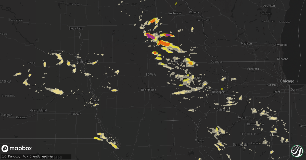
Hail Map in Iowa on June 9, 2018
Get this storm
June 9 map
$229
one time, instant access
Download today. No call, no setup
Keep the $229
Bought the map and want the full workflow? Apply the entire $229 to a subscription within 7 days. None of it is wasted.
Every map, not just this one
This buys you this map. Subscription and you get every map we run, in the markets you choose from a few cities to whole states to nationwide. Plus real-time alerts the moment a storm fires.
Contact data
Name, contact info, occupancy, even credit band for addresses in the footprint. You go from where it hit to who to call.
Become the source they trust
Unlimited branding weather history reports on demand. You already have the documented answer ready for the property owner, and you are the one who showed up with it.
Property data and RoofTrace estimates
Pull up any address you have got, its value and the exact code rules for that jurisdiction, straight from One Click Code. Then RoofTrace estimates the squares, pitch, and roof value, priced the way you price.
Storm reports in Iowa
Iowa
| Date | Description |
|---|---|
| 06/09/20186:40 PM CDT | Small tree down |
| 06/09/20186:10 PM CDT | Via kwwl. |
| 06/09/20185:59 PM CDT | A local report indicates 65 MPH wind near 4 SW BOYD |
| 06/09/20185:59 PM CDT | A local report indicates 1.00 inch wind near 4 SW BOYD |
| 06/09/20185:38 PM CDT | Power out in charles city. |
| 06/09/20185:35 PM CDT | Awos station ccy... Charles city airport. |
| 06/09/20185:30 PM CDT | 60mph+ winds damage antenna and had large branches broke off at isu ag research farm. |
| 06/09/20185:29 PM CDT | A local report indicates 60 MPH wind near NASHUA |
| 06/09/20185:22 PM CDT | Power lines down across west-central floyd county. |
| 06/09/20185:18 PM CDT | A local report indicates 60 MPH wind near 2 S CHARLES CITY |
| 06/09/20185:03 PM CDT | A local report indicates 1.00 inch wind near 3 W CHARLES CITY |
| 06/09/20185:00 PM CDT | A local report indicates 80 MPH wind near 4 W FLOYD |
| 06/09/20184:55 PM CDT | A local report indicates 60 MPH wind near 3 W CHARLES CITY |
| 06/09/20184:55 PM CDT | Nickel to golf ball sized hail. |
| 06/09/20184:53 PM CDT | Hay racks blown across farm and through fence. Power out. Report via photo on social media. |
| 06/09/20184:50 PM CDT | Report via social media. |
| 06/09/20184:37 PM CDT | A local report indicates 70 MPH wind near 1 W RUDD |
| 06/09/20184:36 PM CDT | A local report indicates 75 MPH wind near ROCKFORD |
| 06/09/20184:32 PM CDT | A local report indicates 75 MPH wind near 2 W ROCKFORD |
| 06/09/20184:30 PM CDT | Numerous trees down. Time estimated from radar. Report via social media photos. |
| 06/09/20184:30 PM CDT | Farm outbuilding destroyed with debris scattered through across street and through a field. Time estimated from radar. Report via photos on social media. |
| 06/09/20184:30 PM CDT | Trees and limbs down... Light pole down on outbuilding... And bleachers blown through fence at rockville high school baseball/softball complex. Time estimated from rada |
| 06/09/20184:27 PM CDT | A local report indicates 1.75 inch wind near 2 S NORA SPRINGS |
| 06/09/20183:54 PM CDT | A local report indicates 71 MPH wind near 3 NE CLEAR LAKE |
| 06/09/20183:44 PM CDT | Via social media. |
| 06/09/20183:36 PM CDT | Via live streaming by severe studios. |
| 06/09/20183:11 PM CDT | Brief rope tornado reported by storm chaser who was 4 ene of forest city. |
| 06/09/20183:00 PM CDT | A local report indicates 2.00 inch wind near LELAND |
| 06/09/20182:55 PM CDT | A local report indicates 2.50 inch wind near 2 NNW LELAND |
| 06/09/20181:05 PM CDT | A local report indicates 1.00 inch wind near 4 N OSAGE |
| 06/09/20188:45 AM CDT | Mix of pea to quarter sized hail. |
| 06/09/20187:16 AM CDT | At 1216 AM CDT, a severe thunderstorm was located near Illinois City, or 12 miles east of Muscatine, moving northeast at 5 mph. HAZARD...60 mph wind gusts and half dollar size hail. SOURCE...Radar indicated. IMPACT...Hail damage to vehicles is expected. Expect wind damage to roofs, siding, and trees. Locations impacted include... Andalusia, Reynolds, Taylor Ridge, Illinois City, Edgington, Loud Thunder Forest Preserve and Loud Thunder Scout Camp. |
| 06/09/20186:16 AM CDT | At 1116 PM CDT, a severe thunderstorm was located over Stanwood, moving east at 40 mph. HAZARD...60 mph wind gusts. SOURCE...Radar indicated. IMPACT...Expect damage to roofs, siding, and trees. Locations impacted include... Mechanicsville, Stanwood, Lowden, Wheatland, Olin, Grand Mound, Delmar, Oxford Junction, Lost Nation, Calamus, Welton, Toronto, Clarence, Massillon Park, Oxford Mills, Big Rock, Elwood, Sherman Park and Walnut Grove Park. |
| 06/09/20185:56 AM CDT | At 1056 PM CDT, a severe thunderstorm was located near Millersburg, or 13 miles north of Sigourney, moving east at 35 mph. HAZARD...Quarter size hail. SOURCE...Radar indicated. IMPACT...Damage to vehicles is expected. Locations impacted include... Wellman, North English, Keswick, South English, Parnell, Millersburg, Kinross, Webster and Holbrook. |
| 06/09/20185:42 AM CDT | At 1041 PM CDT, severe thunderstorms were located along a line extending from near Prairieburg to Robins to near Atkins, moving east at 35 mph. HAZARD...60 mph wind gusts. SOURCE...Radar indicated. IMPACT...Expect damage to roofs, siding, and trees. Locations impacted include... Cedar Rapids, Anamosa, Marion, Hiawatha, Mount Vernon, Monticello, Robins, Center Point, Lisbon, Fairfax, Ely, Atkins, Central City, Springville, Palo, Shellsburg, Olin, Alburnett, Coggon and Wyoming.This includes Interstate 380 between mile markers 13 and 36. |
| 06/09/20184:45 AM CDT | At 944 PM CDT, severe thunderstorms were located along a line extending from near Hazleton to near Quasqueton to near Dysart, moving east at 40 mph. HAZARD...70 mph wind gusts and half dollar size hail. SOURCE...Radar indicated. IMPACT...Hail damage to vehicles is expected. Expect considerable tree damage. Wind damage is also likely to mobile homes, roofs, and outbuildings. Locations impacted include... Independence, Manchester, Dyersville, Monticello, Center Point, Urbana, Central City, Winthrop, Earlville, Walker, Alburnett, Coggon, Hopkinton, Quasqueton, Delhi, Ryan, Brandon, Rowley, Prairieburg and Dundee.This includes Interstate 380 between mile markers 36 and 55. |
| 06/09/20184:44 AM CDT | At 944 PM CDT, a severe thunderstorm was located over Ladora, or 8 miles southwest of Marengo, moving east at 30 mph. HAZARD...60 mph wind gusts and quarter size hail. SOURCE...Radar indicated. IMPACT...Hail damage to vehicles is expected. Expect wind damage to roofs, siding, and trees. Locations impacted include... Marengo, Williamsburg, Victor, Ladora, Amana, Conroy, Middle Amana, South Amana, Homestead, West Amana, Upper South Amana, East Amana, Genoa Bluff, High Amana and Iowa County Fairgrounds.This includes Interstate 80 in Iowa between mile markers 205 and 229. |
| 06/09/20184:20 AM CDT | At 919 PM CDT, severe thunderstorms were located along a line extending from Shellsburg to near Marengo, moving east at 25 mph. HAZARD...60 mph wind gusts and quarter size hail. SOURCE...Radar indicated. IMPACT...Hail damage to vehicles is expected. Expect wind damage to roofs, siding, and trees. Locations impacted include... Cedar Rapids, Vinton, Marion, Hiawatha, Mount Vernon, Robins, Center Point, Lisbon, Fairfax, Ely, Atkins, Walford, Central City, Springville, Palo, Shellsburg, Newhall, Blairstown, Van Horne and Alburnett.This includes Interstate 380 between mile markers 12 and 37. |
| 06/09/20184:13 AM CDT | At 913 PM CDT, a severe thunderstorm was located 8 miles northeast of Eldora, moving east at 25 mph. HAZARD...Quarter size hail. SOURCE...Radar indicated. IMPACT...Damage to vehicles is expected. Locations impacted include... Grundy Center, Wellsburg and Holland. |
| 06/09/20184:10 AM CDT | At 909 PM CDT, severe thunderstorms were located along a line extending from near Fairbank to near Jesup to 7 miles south of Crossroads Mall, moving southeast at 25 mph. HAZARD...60 mph wind gusts and quarter size hail. SOURCE...Radar indicated. IMPACT...Hail damage to vehicles is expected. Expect wind damage to roofs, siding, and trees. Locations impacted include... Independence, Jesup, Fairbank, Hazleton, Brandon, Rowley, Aurora, Stanley, Lime Creek County Park, Wapsipinicon Golf Course, Fontana County Park, Littleton, Buchanan County Fairgrounds, Otterville, Spencers Grove, Independence Airport, Jakway Park, Fontana Park, Cheney and Minne Estema Park.This includes Interstate 380 between mile markers 44 and 55. |
| 06/09/20183:51 AM CDT | At 851 PM CDT, severe thunderstorms were located along a line extending from near Denver to Waterloo to near Dike, moving southeast at 30 mph. HAZARD...60 mph wind gusts and quarter size hail. SOURCE...Radar indicated. IMPACT...Hail damage to vehicles is expected. Expect wind damage to roofs, siding, and trees. Locations impacted include... Waterloo, Cedar Falls, Evansdale, Jesup, La Porte City, Hudson, Dysart, Dike, Elk Run Heights, Crossroads Mall, Waterloo Municipal Airport, Uni-Dome And McLeod Center, Janesville, Washburn, Dunkerton, Raymond, Gilbertville and George Wyth State Park.This includes Interstate 380 between mile markers 56 and 73. |
| 06/09/20183:47 AM CDT | At 847 AM CDT, severe thunderstorms were located along a line extending from Center Point to near Marion to near Lake Macbride State Park, moving northeast at 10 mph. HAZARD...Quarter size hail. SOURCE...Trained weather spotters. IMPACT...Damage to vehicles is expected. Locations impacted include... Cedar Rapids, Marion, Hiawatha, Mount Vernon, Robins, Center Point, Lisbon, Solon, Ely, Central City, Springville, Palo, Swisher, Walker, Alburnett, Coggon, Shueyville, Bertram, Prairieburg and Toddville.This includes Interstate 380 between mile markers 8 and 39. |
| 06/09/20183:44 AM CDT | At 844 PM CDT, severe thunderstorms were located along a line extending from Lamont to near Winthrop to near Quasqueton, moving east at 20 mph. HAZARD...Ping pong ball size hail and 60 mph wind gusts. SOURCE...Radar indicated. IMPACT...People and animals outdoors will be injured. Expect hail damage to roofs, siding, windows, and vehicles. Expect wind damage to roofs, siding, and trees. Locations impacted include... Independence, Manchester, Edgewood, Winthrop, Earlville, Quasqueton, Lamont, Delhi, Colesburg, Ryan, Rowley, Greeley, Aurora, Dundee, Delaware, Masonville, Stanley, Oneida, Manchester Airport and Monti. |
| 06/09/20182:51 AM CDT | At 750 PM CDT, a severe thunderstorm was located near Jesup, or 11 miles northwest of Independence, moving east at 20 mph. HAZARD...60 mph wind gusts and quarter size hail. SOURCE...Radar indicated. IMPACT...Hail damage to vehicles is expected. Expect wind damage to roofs, siding, and trees. Locations impacted include... Independence, Jesup, Fairbank, Winthrop, Hazleton, Lamont, Aurora, Stanley, Winthrop Golf Course, Wapsipinicon Golf Course, Fontana County Park, Littleton, Buchanan County Fairgrounds, Otterville, Jakway Park and Fontana Park. |
| 06/09/20182:46 AM CDT | At 745 PM CDT, a severe thunderstorm was located near Iowa Falls, moving east at 25 mph. HAZARD...60 mph wind gusts and quarter size hail. SOURCE...Radar indicated. IMPACT...Hail damage to vehicles is expected. Expect wind damage to roofs, siding, and trees. Locations impacted include... Parkersburg, Ackley, Aplington and Bradford. |
| 06/09/20182:30 AM CDT | At 730 PM CDT, a severe thunderstorm was located near Denver, or 7 miles northeast of Waterloo, moving east at 25 mph. HAZARD...60 mph wind gusts and quarter size hail. SOURCE...Radar indicated. IMPACT...Hail damage to vehicles is expected. Expect wind damage to roofs, siding, and trees. Locations impacted include... Waterloo, Jesup and Dunkerton. |
| 06/09/20182:21 AM CDT | At 721 PM CDT, a severe thunderstorm was located near Hampton, moving east at 25 mph. HAZARD...60 mph wind gusts and half dollar size hail. SOURCE...Radar indicated. IMPACT...Hail damage to vehicles is expected. Expect wind damage to roofs, siding, and trees. Locations impacted include... Hampton, Allison, Dumont, Geneva, Bristow, Hansell and Allison Municipal Airport. |
| 06/09/20181:58 AM CDT | At 658 PM CDT, a severe thunderstorm was located 8 miles northwest of Hampton, moving east at 25 mph. HAZARD...Half dollar size hail. SOURCE...Radar indicated. IMPACT...Damage to vehicles is expected. Locations impacted include... Hampton, Sheffield, Latimer, Coulter, Hansell, Chapin, Hampton Municipal Airport and Beeds Lake State Park.This includes Interstate 35 between mile markers 164 and 175. |
| 06/09/20181:20 AM CDT | At 619 PM CDT, severe thunderstorms were located along a line extending from near Protivin to near Lawler to near Waucoma, moving northeast at 30 mph. HAZARD...60 mph wind gusts. SOURCE...Radar indicated. IMPACT...Expect damage to roofs, siding, and trees. Severe thunderstorms will be near... Fort Atkinson and Spillville around 635 PM CDT. Calmar around 640 PM CDT. Ossian around 655 PM CDT. Decorah around 700 PM CDT. Other locations impacted by these severe thunderstorms includeCastalia, Jackson Junction, State Road 9 And 245th Street, Festinaand Frankville. |
| 06/09/20181:09 AM CDT | At 608 PM CDT, a severe thunderstorm was located near Nashua, or 11 miles northwest of Waverly, moving southeast at 25 mph. HAZARD...60 mph wind gusts and quarter size hail. SOURCE...Radar indicated. IMPACT...Hail damage to vehicles is expected. Expect wind damage to roofs, siding, and trees. Locations impacted include... Waverly, Sumner, Denver, Tripoli, Janesville, Readlyn, Plainfield, Frederika and Waverly Municipal Airport. |
| 06/09/20181:07 AM CDT | At 606 PM CDT, a severe thunderstorm was located over Fredericksburg, or 8 miles southeast of New Hampton, moving east at 25 mph. Another cluster of storms was moving in from Bremer County as well. HAZARD...70 mph wind gusts. SOURCE...Emergency management. IMPACT...Expect considerable tree damage. Damage is likely to mobile homes, roofs, and outbuildings. This severe thunderstorm will be near... Waucoma around 625 PM CDT. Hawkeye around 640 PM CDT. West Union and Fayette around 655 PM CDT. Clermont around 715 PM CDT. Elgin around 720 PM CDT. Other locations impacted by this severe thunderstorm include Wadena,Westgate, St. Lucas, Randalia and Donnan. |
| 06/09/201812:58 AM CDT | At 557 PM CDT, a severe thunderstorm was located near New Hampton, moving east at 25 mph. Another severe thunderstorm was tracking across southern Floyd County, north of Greene Iowa. HAZARD...70 mph wind gusts. SOURCE...Radar indicated. IMPACT...Expect considerable tree damage. Damage is likely to mobile homes, roofs, and outbuildings. This severe thunderstorm will be near... Fredericksburg around 605 PM CDT. Lawler around 610 PM CDT. Other locations impacted by this severe thunderstorm includeChickasaw, North Washington, Bassett, Bradford and New HamptonAirport.People attending Heartland Days should seek safe shelter immediately!This warning extends the previous severe thunderstorm warning. |
| 06/09/201812:39 AM CDT | At 539 PM CDT, a severe thunderstorm was located near Greene, or 11 miles northwest of Allison, moving east at 20 mph. HAZARD...60 mph wind gusts and half dollar size hail. SOURCE...Radar indicated. IMPACT...Hail damage to vehicles is expected. Expect wind damage to roofs, siding, and trees. Locations impacted include... Clarksville and Greene. |
| 06/09/201812:10 AM CDT | Downed limb. |
| 06/08/201811:41 PM CDT | At 440 PM CDT, a severe thunderstorm was located over Floyd, or near Charles City, moving east at 35 mph. HAZARD...Golf ball size hail and 70 mph wind gusts. SOURCE...Trained weather spotters. IMPACT...People and animals outdoors will be injured. Expect hail damage to roofs, siding, windows, and vehicles. Expect considerable tree damage. Wind damage is also likely to mobile homes, roofs, and outbuildings. This severe thunderstorm will be near... Charles City around 445 PM CDT. Nashua around 500 PM CDT. Ionia around 505 PM CDT. New Hampton around 515 PM CDT. Jerico around 520 PM CDT. Fredericksburg around 525 PM CDT. Lawler and Protivin around 530 PM CDT. Other locations impacted by this severe thunderstorm includeChickasaw, Alta Vista, North Washington, Colwell and Bassett.People attending Heartland Days should seek safe shelter immediately!This warning extends the previous Severe Thunderstorm Warning for Floyd County. |
| 06/08/201811:28 PM CDT | At 427 AM CDT, severe thunderstorms were located along a line extending from near Argo Fay to near Donahue, moving southeast at 40 mph. HAZARD...60 mph wind gusts and nickel size hail. SOURCE...Radar indicated. IMPACT...Expect damage to roofs, siding, and trees. Locations impacted include... Davenport, Moline, Rock Island, Bettendorf, Clinton, East Moline, Sterling, Morrison, Silvis, Eldridge, DeWitt, Colona, Camanche, Le Claire, Coal Valley, Fulton, Savanna, Prophetstown, Hampton and Port Byron.This includes the following highways... Interstate 74 in Iowa between mile markers 1 and 5. Interstate 80 in Iowa between mile markers 292 and 306. Interstate 80 in Illinois between mile markers 1 and 12. Interstate 74 in Illinois between mile markers 1 and 15. Interstate 88 between mile markers 1 and 37. Interstate 280 between mile markers 17 and 18. |
| 06/08/201811:09 PM CDT | Multiple trees snapped off about halfway up along highway 13 north of manchester. Time estimated from radar. |
| 06/08/201810:57 PM CDT | At 356 PM CDT, a severe thunderstorm was located near Rockwell, or 7 miles south of Mason City, moving east at 20 mph. HAZARD...Half dollar size hail. SOURCE...Radar indicated. IMPACT...Damage to vehicles is expected. Locations impacted include... Mason City, Nora Springs, Rockwell, Mason City Municipal Airport, Clear Lake, Ventura, Plymouth, Fertile, Rock Falls, Burchinal, Portland and Clear Lake State Park.This includes Interstate 35 between mile markers 184 and 202. |
| 06/08/201810:51 PM CDT | At 350 PM CDT, a severe thunderstorm was located near Nora Springs, or 8 miles east of Mason City, moving east at 35 mph. HAZARD...Ping pong ball size hail and 60 mph wind gusts. SOURCE...Radar indicated. IMPACT...People and animals outdoors will be injured. Expect hail damage to roofs, siding, windows, and vehicles. Expect wind damage to roofs, siding, and trees. There have been tornado reports in north central Iowa earlier this afternoon from this same storm as well. This severe thunderstorm will be near... Rockford around 400 PM CDT. Rudd and Marble Rock around 405 PM CDT. Osage around 410 PM CDT. Charles City and Floyd around 420 PM CDT. Other locations impacted by this severe thunderstorm include Colwell,Orchard, County Roads B 60 And T 18, Rock Creek and Howards WoodRecreational Area. |
| 06/08/201810:46 PM CDT | Relayed by local broadcast media. |
| 06/08/201810:09 PM CDT | Multiple trees snapped off about halfway up along highway 13 north of manchester. Time estimated from radar. |
| 06/08/201810:00 PM CDT | A local report indicates 65 MPH wind near 2 SW MASONVILLE |
| 06/08/20189:52 PM CDT | At 251 PM CDT, a severe thunderstorm was located 7 miles north of Forest City, moving east at 15 mph. HAZARD...Quarter size hail. SOURCE...Radar indicated. IMPACT...Damage to vehicles is expected. Locations impacted include... Lake Mills, Rice Lake, Leland, Joice, Lake Mills Municipal Airport and Rice Lake State Park. |
| 06/08/20189:50 PM CDT | A local report indicates 60 MPH wind near WINTHROP |
| 06/08/20189:36 PM CDT | An ef-1 tornado touched down southeast of winthrop... Ia. A house was damaged. Garage door failed and roof came off in the wind. Some tree damage was also noted. The du |
| 06/08/20189:34 PM CDT | Relayed a report of thunderstorm wind damage in watkin. Tree limbs down. Time estimated using radar. |
| 06/08/20189:24 PM CDT | Relayed by benton county em. |
| 06/08/20189:20 PM CDT | Roof blown off of a home. Relayed by the em. Time estimated from radar. |
| 06/08/20189:20 PM CDT | Estimated wind gust of 70 mph and quarter hail.... |
| 06/08/20189:18 PM CDT | A local report indicates 1.00 inch wind near 1 NE INDEPENDENCE |
| 06/08/20189:02 PM CDT | A local report indicates 1.00 inch wind near 1 ESE INDEPENDENCE |
| 06/08/20188:35 PM CDT | Trees at about a 45 degree angle... No tree damage visibile. |
| 06/08/20188:10 PM CDT | At 110 PM CDT, a severe thunderstorm was located near Riceville, or 10 miles northeast of Osage, moving east at 15 mph. HAZARD...60 mph wind gusts and quarter size hail. SOURCE...Radar indicated. IMPACT...Hail damage to vehicles is expected. Expect wind damage to roofs, siding, and trees. This severe thunderstorm will be near... Riceville around 125 PM CDT. Elma around 140 PM CDT. Lime Springs around 215 PM CDT. Other locations impacted by this severe thunderstorm include Chester,Lylahs Marsh County Park, Saratoga, Davis Corners and County B 17 AndBell Avenue. |
| 06/08/20188:00 PM CDT | Mostly pea to nickel hail with a few to the size of quarters. |
| 06/08/20187:28 PM CDT | Nickle to quarter sized hail - via social media. |
| 06/08/20187:27 PM CDT | Large branches and power lines down |
| 06/08/20187:14 PM CDT | Trees down. Time estimated from radar. |
| 06/08/20187:14 PM CDT | Reports of power lines and branches down |
| 06/08/20187:11 PM CDT | A local report indicates 1.75 inch wind near 2 NE LATIMER |
| 06/08/20187:00 PM CDT | Trees and power lines down. Time estimate from radar. |
All States Impacted by Hail Map on June 9, 2018
Cities Impacted by Hail Map on June 9, 2018
- Spring Grove, MN
- Decorah, IA
- Mabel, MN
- Winchester, VA
- Clear Brook, VA
- Stephens City, VA
- White Post, VA
- Pierson, IA
- Anthon, IA
- Correctionville, IA
- Moville, IA
- Mosquero, NM
- Moselle, MS
- Ellisville, MS
- Ellendale, MN
- Clarks Grove, MN
- Hartland, MN
- Albert Lea, MN
- Alden, MN
- Oneonta, AL
- Norway, IA
- Marengo, IA
- Blairstown, IA
- Watkins, IA
- Falls City, NE
- Geneva, IA
- Hampton, IA
- Fertile, IA
- Clear Lake, IA
- Hanlontown, IA
- Manly, IA
- Mason City, IA
- Preston, IA
- Atkinson, IL
- Cambridge, IL
- Kewanee, IL
- Chenoa, IL
- Pontiac, IL
- Edinburg, VA
- Shorterville, AL
- Abbeville, AL
- Newville, AL
- Mount Auburn, IA
- Vinton, IA
- Ottawa, KS
- Prosperity, SC
- Little Mountain, SC
- Chapin, SC
- Moores Hill, IN
- Aurora, IN
- Iowa City, IA
- Keswick, IA
- Barnes City, IA
- What Cheer, IA
- Gibson, IA
- Lawton, IA
- Papillion, NE
- Omaha, NE
- Springfield, NE
- La Vista, NE
- Chatsworth, IL
- Roberts, IL
- Thawville, IL
- Alexander, IA
- Latimer, IA
- Coulter, IA
- Dupo, IL
- Columbia, IL
- East Carondelet, IL
- Washington, IA
- Iowa Falls, IA
- Ackley, IA
- Sidell, IL
- Indianola, IL
- Fairmount, IL
- Offutt Afb, NE
- Bellevue, NE
- Montour, IA
- Toledo, IA
- Garwin, IA
- Bixby, MO
- Montevallo, AL
- Easton, MN
- Delavan, MN
- Georgetown, MN
- Argusville, ND
- Carroll, IA
- Breda, IA
- Cedar Rapids, IA
- Humboldt, IL
- Charleston, IL
- Mattoon, IL
- Sheffield, IA
- Dougherty, IA
- Creighton, NE
- Royal, NE
- Winnetoon, NE
- Brunswick, NE
- Charter Oak, IA
- Gillette, WY
- Dana, IL
- Benson, IL
- Minonk, IL
- Chinook, MT
- Harlem, MT
- Salem, NE
- Morrill, KS
- Dawson, NE
- Sabetha, KS
- Odell, IL
- Dwight, IL
- Emington, IL
- Homer, IL
- Saint Joseph, IL
- Sidney, IL
- Heathsville, VA
- Kilmarnock, VA
- Cologne, MN
- Chaska, MN
- Carver, MN
- Morton, MS
- Amana, IA
- Avon, SD
- Hall, MT
- Philipsburg, MT
- Drummond, MT
- Corvallis, MT
- Rudd, IA
- Marble Rock, IA
- Greene, IA
- Charles City, IA
- Nora Springs, IA
- Rockford, IA
- Tinnie, NM
- Salem, IL
- Odin, IL
- Wellman, IA
- Curryville, MO
- Vandalia, MO
- Salem, MO
- Tallahassee, FL
- Keystone Heights, FL
- Brayton, IA
- Atlantic, IA
- Walnut, IA
- Audubon, IA
- Marne, IA
- Kimballton, IA
- Harlan, IA
- Elk Horn, IA
- Exira, IA
- Keystone, IA
- Van Horne, IA
- Elberon, IA
- Buckatunna, MS
- Glenville, MN
- Tripp, SD
- Scotland, SD
- Craig, MO
- Sullivan, IN
- Merom, IN
- Marshfield, MO
- Seymour, MO
- Laurel Hill, FL
- Crestview, FL
- South English, IA
- Webster, IA
- North English, IA
- Monticello, IL
- Wellsburg, IA
- Thurston, NE
- Pender, NE
- Emerson, NE
- Wakefield, NE
- Tipton, IA
- Wadena, IA
- Fayette, IA
- Rochester, IL
- Pecos, TX
- Kensett, IA
- Moccasin, MT
- Stanford, MT
- Wells, MN
- Denton, MT
- Winifred, MT
- French Lick, IN
- Paoli, IN
- Verdigre, NE
- Odebolt, IA
- Scotia, NE
- Gladstone, VA
- Arlington, IA
- Volga, IA
- Alzada, MT
- Belle Fourche, SD
- Niobrara, NE
- Otter, MT
- Tappahannock, VA
- Covington, IN
- Onawa, IA
- Whiting, IA
- Griggsville, IL
- Hammond, MT
- Harmony, MN
- Cresco, IA
- Shipman, IL
- Brighton, IL
- Vienna, MD
- Waynesville, OH
- Roodhouse, IL
- Greenfield, IL
- Frost, MN
- Bricelyn, MN
- Astoria, IL
- Rushville, IL
- Laurel, NE
- Dixon, NE
- North Henderson, IL
- Rio, IL
- Dysart, IA
- Parnell, IA
- Saint Louis, MO
- Chambers, NE
- Georgetown, IL
- Ridge Farm, IL
- Mobile, AL
- Monroe, NE
- Columbus, NE
- Platte Center, NE
- Genoa, NE
- Palestine, IL
- Jordan, MN
- Strafford, MO
- Humboldt, NE
- Hiawatha, KS
- Bern, KS
- Centralia, IL
- Sandoval, IL
- Hoyleton, IL
- Gurdon, AR
- Emmons, MN
- Northwood, IA
- Hayward, MN
- Shellsburg, IA
- Urbana, IA
- Dodge, NE
- Rogers, NE
- Weems, VA
- Lancaster, VA
- Hillsboro, ND
- Parkersburg, IA
- Homestead, IA
- Eldora, IA
- Forest City, IA
- Leland, IA
- La Porte City, IA
- Jesup, IA
- Alamo, TN
- Hollandale, MN
- Crofton, NE
- Kingsley, IA
- Bronson, IA
- Troy, KS
- Hettick, IL
- Elk Point, SD
- Jefferson, SD
- Conchas Dam, NM
- Ohatchee, AL
- Hoopeston, IL
- Rankin, IL
- Wellington, IL
- Bismarck, MO
- Doe Run, MO
- Ironton, MO
- Plymouth, IL
- Macomb, IL
- Littleton, IL
- Industry, IL
- Bluffs, IL
- Chapin, IL
- Arenzville, IL
- Versailles, IL
- Jacksonville, IL
- Meredosia, IL
- Beardstown, IL
- Mount Sterling, IL
- Chambersburg, IL
- Downs, IL
- Bloomington, IL
- Mason, IL
- Watson, IL
- Edgewood, IL
- Hutsonville, IL
- Robinson, IL
- Allen, NE
- Hartington, NE
- Augusta, WV
- Delray, WV
- Cissna Park, IL
- Milford, IL
- Upland, IN
- Hartford City, IN
- Montpelier, IN
- Grundy Center, IA
- Frisco City, AL
- Middletown, VA
- Birmingham, AL
- Bessemer, AL
- Golden Gate, IL
- Coffee Creek, MT
- Janesville, IA
- Waterloo, IA
- Cedar Falls, IA
- Waverly, IA
- New Hartford, IA
- Granite City, IL
- Bird Island, MN
- Morton, MN
- Franklin, MN
- Cherokee, IA
- Lake Mills, IA
- Thompson, IA
- Belle Plaine, MN
- Henderson, MN
- Le Sueur, MN
- West Union, IA
- Walthill, NE
- Marion Junction, AL
- Buena Vista, GA
- Bloomfield, NE
- Fordyce, NE
- Lloyd, MT
- Muncie, IN
- Blakely, GA
- Ryan, IA
- Manchester, IA
- Fort Washington, MD
- Accokeek, MD
- Waterloo, IL
- Valmeyer, IL
- Fults, IL
- Headland, AL
- Ozark, AL
- Yazoo City, MS
- Joice, IA
- Amelia, NE
- Vermont, IL
- Browning, IL
- Independence, IA
- Millville, NJ
- Bridgeton, NJ
- Cambridge, MD
- Rhodesdale, MD
- Goose Lake, IA
- Bryant, IA
- Charlotte, IA
- Gladbrook, IA
- Reinbeck, IA
- Neligh, NE
- Tuskegee, AL
- Chelsea, IA
- Clutier, IA
- Stockport, IA
- Lockridge, IA
- Clifton, VA
- Prairie, MS
- Lakeland, GA
- Naylor, GA
- Altona, IL
- Galva, IL
- Bishop Hill, IL
- Semmes, AL
- Wathena, KS
- Bonne Terre, MO
- Fairfield, IA
- Greeley, NE
- Osawatomie, KS
- Seaford, DE
- Bethel, DE
- Atkins, IA
- Palo, IA
- Vining, IA
- Belle Plaine, IA
- Luzerne, IA
- Newhall, IA
- Walford, IA
- Fairfax, IA
- South Amana, IA
- Swisher, IA
- Hiawatha, IA
- Ladora, IA
- North Liberty, IA
- Middle Amana, IA
- Victor, IA
- Oxford, IA
- Gaston, IN
- Atwood, IL
- Arthur, IL
- Lovington, IL
- Highland, KS
- Bendena, KS
- Hogeland, MT
- Monroe, VA
- Madison Heights, VA
- Thomson, IL
- Chadwick, IL
- Morrison, IL
- Milledgeville, IL
- Fulton, IL
- Albion, NE
- Primrose, NE
- Gardner, ND
- Strawberry Point, IA
- Waterbury, NE
- Hubbard, NE
- Jackson, NE
- Tama, IA
- Carlyle, IL
- England, AR
- Enterprise, AL
- Rowley, IA
- Le Center, MN
- Woodbine, IA
- Albany, IL
- Hillsdale, IL
- Camden, AL
- Alberta, AL
- Catherine, AL
- Pine Hill, AL
- Bryant, IN
- Pennville, IN
- Dunkirk, IN
- Osage, IA
- Stanley, IA
- Hays, MT
- Adair, IL
- Upper Marlboro, MD
- Aladdin, WY
- Ericson, NE
- Ord, NE
- Burwell, NE
- Martinsville, IL
- Casey, IL
- Big Sandy, MT
- Pacific Junction, IA
- Council Bluffs, IA
- Glenwood, IA
- Prattville, AL
- Concord, IL
- Holt, FL
- La Fayette, IL
- Claude, TX
- Capitol, MT
- Hulett, WY
- Dike, IA
- Dozier, AL
- Perry, IL
- Winchester, IL
- Ambrose, GA
- Broxton, GA
- Ponca, NE
- Westfield, IA
- Alpha, IL
- Mineral, VA
- Troy, AL
- Jack, AL
- Temple Hills, MD
- Suitland, MD
- Mechanicsburg, OH
- Wickliffe, KY
- Charleston, MO
- Moss Point, MS
- Bunker, MO
- Warwick, GA
- Sylvester, GA
- Lime Springs, IA
- Chester, IA
- Princeton, IL
- Buda, IL
- Sheffield, IL
- Tiskilwa, IL
- Wyanet, IL
- Bowen, IL
- Augusta, IL
- Huntsville, IL
- Patoka, IL
- Bartelso, IL
- Hoffman, IL
- Kell, IL
- Williamsport, IN
- Middletown, IN
- Winthrop, IA
- Quasqueton, IA
- Hazleton, IA
- Masonville, IA
- Fairbank, IA
- Rantoul, IL
- Mount Pleasant, IA
- Concord, NE
- Riceville, IA
- Sterling, IL
- Gretna, NE
- Marion, IN
- Saraland, AL
- Chunchula, AL
- Bellwood, NE
- Randolph, NE
- Coleridge, NE
- Perry, MO
- Eminence, MO
- Carlisle, IN
- Guernsey, IA
- Verdon, NE
- Sacred Heart, MN
- Olivia, MN
- Grinnell, IA
- Gilman, IA
- Remsen, IA
- Marcus, IA
- Stonington, IL
- New Madison, OH
- Arcanum, OH
- Oregon, MO
- Five Points, AL
- Roanoke, AL
- Shirley, IL
- McLean, IL
- Columbus, GA
- Mclean, NE
- Rockwell, IA
- Monmouth, IL
- Theodore, AL
- Irvington, AL
- Grand Bay, AL
- Fredericksburg, IA
- New Hampton, IA
- Sumner, IA
- Frederika, IA
- Tripoli, IA
- Nashua, IA
- Ionia, IA
- Floyd, IA
- Prince Frederick, MD
- Huntingtown, MD
- Humphrey, NE
- Alexandria, VA
- Park Hills, MO
- Irondale, MO
- Aplington, IA
- Wabash, IN
- Taylorville, IL
- Paola, KS
- Opp, AL
- Walnut, IL
- Tampico, IL
- Hamilton, GA
- Saint Joseph, MO
- Paxton, IL
- Mount Olive, IL
- Klemme, IA
- Swaledale, IA
- Thornton, IA
- Seaton, IL
- Aledo, IL
- Alexis, IL
- Viola, IL
- Traer, IA
- Blomkest, MN
- Milton, FL
- Steamboat Rock, IA
- Tyndall, SD
- Dieterich, IL
- Irwin, IA
- Defiance, IA
- Le Roy, IL
- White Cloud, KS
- Robinson, KS
- Rulo, NE
- Lindsay, NE
- Saint Edward, NE
- Amherst, VA
- Alma, GA
- Mankato, MN
- Janesville, MN
- Saint Clair, MN
- Elma, IA
- Westgate, IA
- Saint Ansgar, IA
- Plymouth, IA
- Plainfield, IA
- Ventura, IA
- Allison, IA
- Garner, IA
- Scarville, IA
- Grafton, IA
- Bristow, IA
- Clarksville, IA
- Little Cedar, IA
- Plattsmouth, NE
- Lonoke, AR
- Olin, IA
- Anamosa, IA
- Assumption, IL
- Moweaqua, IL
- De Soto, MO
- Saint Olaf, IA
- Louisville, NE
- Hillsdale, IN
- Dana, IN
- Dunkerton, IA
- Streator, IL
- Greenville, OH
- Cairo, IL
- Rison, AR
- Smithville, GA
- Marianna, FL
- Altha, FL
- Mapleton, MN
- Darfur, MN
- The Plains, VA
- Red Bud, IL
- Cullom, IL
- Rolla, MO
- Eight Mile, AL
- Geneva, MN
- Blooming Prairie, MN
- Saunemin, IL
- Fairbury, IL
- Forrest, IL
- Farmington, MO
- Altoona, AL
- Portland, IN
- Aurora, IA
- Brandon, IA
- Coggon, IA
- Walker, IA
- Normal, IL
- Cut Bank, MT
- Erie, IL
- Ellsworth, IL
- Hot Springs National Park, AR
- New Sharon, IA
- Deep River, IA
- Clinton, MD
- District Heights, MD
- Columbus Junction, IA
- New Brockton, AL
- Maynard, MN
- Montevideo, MN
- West Liberty, IA
- Atalissa, IA
- Sleepy Eye, MN
- Greenville, AL
- Solon, IA
- Mount Vernon, IA
- Lisbon, IA
- Mechanicsville, IA
- Flanagan, IL
- Dugspur, VA
- Knoxville, IL
- Gilson, IL
- Federalsburg, MD
- Denton, MD
- Patoka, IN
- Decker, IN
- Hingham, MT
- Atkinson, NE
- Saint James, MN
- De Witt, IA
- Clinton, IA
- Valdosta, GA
- Adel, GA
- Hahira, GA
- Ray City, GA
- Georgetown, DE
- Dewey, IL
- Mount Erie, IL
- Albion, IL
- West Salem, IL
- Black, MO
- Birch Tree, MO
- Holland, IA
- Fort Benton, MT
- Chesterfield, IL
- Palmyra, IL
- Petal, MS
- Ovett, MS
- Magnet, NE
- Fieldon, IL
- Macy, NE
- Strawn, IL
- Fertile, MN
- Springfield, MN
- Denison, IA
- Lafayette, AL
- Cataula, GA
- Table Grove, IL
- Colchester, IL
- Camden, IL
- Wilmer, AL
- Argenta, IL
- Arabi, GA
- Philo, IL
- Urbana, IL
- Bainbridge, OH
- Hardin, IL
- Andrews Air Force Base, MD
- Brandywine, MD
- Capitol Heights, MD
- Blue Earth, MN
- Winnebago, MN
- Moscow, IA
- Halls, TN
- Mark, IL
- Granville, IL
- Keota, IA
- Sigourney, IA
- Harper, IA
- Kingman, IN
- Hudson, IA
- Flat Rock, IL
- Annapolis, IL
- West York, IL
- Lynchburg, VA
- Marbury, AL
- Soldier, IA
- Wataga, IL
- Galesburg, IL
- Herculaneum, MO
- Festus, MO
- Pevely, MO
- Wagarville, AL
- Forest Home, AL
- West Branch, IA
- Woodford, VA
- Spotsylvania, VA
- O'Fallon, MO
- Lexington, MS
- Rantoul, KS
- Delaplane, VA
- Okolona, MS
- Kalispell, MT
- Auburn, IA
- Muscatine, IA
- Vancleave, MS
- Gildford, MT
- Decatur, NE
- Alvin, IL
- Henning, IL
- Rossville, IL
- Potomac, IL
- Williamsburg, IA
- Riverside, IA
- Kalona, IA
- Clarence, IA
- Hills, IA
- Stanwood, IA
- Bath, IL
- Clayton, DE
- Dover, DE
- Smyrna, DE
- Jefferson, NC
- Laurel Springs, NC
- High View, WV
- Gore, VA
- Glenwood, GA
- Alamo, GA
- Clearwater, NE
- Elgin, NE
- Bismarck, IL
- Danville, IL
- Solano, NM
- Americus, GA
- Honoraville, AL
- Warsaw, VA
- Bradford, IA
- Alden, IA
- Champaign, IL
- Waynesboro, MS
- Loma, MT
- Midland, GA
- Hope, ND
- Vail, IA
- Bowman, ND
- Austin, MN
- Lawler, IA
- Buckley, IL
- Forest City, MO
- Owings, MD
- Immokalee, FL
- Champlain, VA
- Callao, VA
- Dunnsville, VA
- Farnham, VA
- Leadwood, MO
- Summerdale, AL
- Ewing, NE
- Monticello, FL
- Felda, FL
- Durant, IA
- Bennett, IA
- Wilton, IA
- New Liberty, IA
- Eaton, IN
- Bard, NM
- Hedrick, IA
- Kempton, IL
- Ashkum, IL
- Crescent, IA
- Pomaria, SC
- Chrisman, IL
- Solomons, MD
- Irvine, KY
- Romney, WV
- Box Elder, MT
- Salem, IA
- North Bend, NE
- De Soto, IL
- Carterville, IL
- Live Oak, FL
- McAlpin, FL
- Woodlawn, VA
- Buffalo, SD
- Arcola, IL
- Tuscola, IL
- Hartshorn, MO
- Cuero, TX
- Sioux City, IA
- Sergeant Bluff, IA
- Oelwein, IA
- Rutland, IL
- Sibley, IL
- Melvin, IL
- Piper City, IL
- Graymont, IL
- Heyworth, IL
- Cuthbert, GA
- Twin Valley, MN
- Farmer City, IL
- Maroa, IL
- Nicholls, GA
- Ely, IA
- Brandon, MS
- Hooper, NE
- Blountsville, AL
- Lewisville, MN
- Atchison, KS
- Wellborn, FL
- Malcom, IA
- Brooklyn, IA
- Oneida, IL
- Woodhull, IL
- Toulon, IL
- Wyoming, IL
- Mineral Point, MO
- Shellman, GA
- Choteau, MT
- Ashland, NE
- Bunker Hill, IL
- Gillespie, IL
- Rutledge, AL
- Thomasboro, IL
- Helena, AL
- Bowling Green, MO
- Bement, IL
- Hattiesburg, MS
- Portsmouth, IA
- Geneseo, IL
- Du Bois, NE
- West Alton, MO
- Toledo, IL
- Lone Tree, IA
- Enterprise, MS
- Quitman, MS
- Summersville, MO
- Williamsfield, IL
- Dahinda, IL
- East Saint Louis, IL
- Arnold, MO
- Imperial, MO
- French Village, MO
- Valles Mines, MO
- Rose Hill, MS
- Wausa, NE
- Osmond, NE
- Le Mars, IA
- Saucier, MS
- Jay, FL
- Spalding, NE
- Hennepin, IL
- West Terre Haute, IN
- New Athens, IL
- Mahomet, IL
- Fisher, IL
- Naples, FL
- Lenox, MO
- Edgar Springs, MO
- Licking, MO
- Richland, GA
- Bloomfield, IN
- Bridgeville, DE
- Preston, MD
- Laurel, DE
- Annawan, IL
- Bowling Green, VA
- Tibbie, AL
- Greenville, FL
- Prinsburg, MN
- Cedar Rapids, NE
- Williams, IN
- Wall Lake, IA
- Florissant, MO
- Mentor, MN
- Sweet Grass, MT
- Sunburst, MT
- Mount Union, IA
- Hammond, IL
- Cerro Gordo, IL
- Carmi, IL
- Elberta, AL
- Yellow Spring, WV
- Victoria, IL
- New London, IA
- Florala, AL
- Granite Falls, MN
- Millsboro, DE
- Clara City, MN
- Renville, MN
- Mechanicsburg, IL
- Moody Afb, GA
- Toluca, IL
- Danforth, IL
- McRae Helena, GA
- Cornell, IL
- Louin, MS
- Borup, MN
- Buckingham, IA
- Malmo, NE
- Colon, NE
- Plainview, NE
- Hidalgo, IL
- Prophetstown, IL
- Star Tannery, VA
- Allerton, IL
- Metcalf, IL
- Hume, IL
- Saint Helena, NE
- El Paso, IL
- Wetumpka, AL
- Martelle, IA
- Springville, IA
- Westside, IA
- Arcadia, IA
- Thomasville, AL
- Magee, MS
- Raleigh, MS
- Elgin, IA
- McNabb, IL
- Towanda, IL
- Gifford, IL
- Grafton, IL
- Letts, IA
- Conesville, IA
- Hartly, DE
- Camden Wyoming, DE
- Balmorhea, TX
- Blair, NE
- Belgrade, NE
- Edinburg, IL
- Maurice, LA
- New Prague, MN
- Greenup, IL
- Nashville, GA
- McIntire, IA
- Nickerson, NE
- Carthage, IL
- Trilla, IL
- Lerna, IL
- Anniston, AL
- Wellington, AL
- Newcastle, NE
- Beaman, IA
- Winnebago, NE
- Petersburg, NE
- Schuyler, NE
- Britt, IA
- Goodell, IA
- Hillview, IL
- Patterson, IL
- Galax, VA
- Dante, SD
- Wagner, SD
- Wolbach, NE
- Pawnee, IL
- Riverton, IL
- Springfield, IL
- Labelle, FL
- Alva, FL
- Eldridge, IA
- Le Claire, IA
- Davenport, IA
- Bettendorf, IA
- Broadus, MT
- Lake City, MN
- Zumbro Falls, MN
- Freeborn, MN
- New Richland, MN


