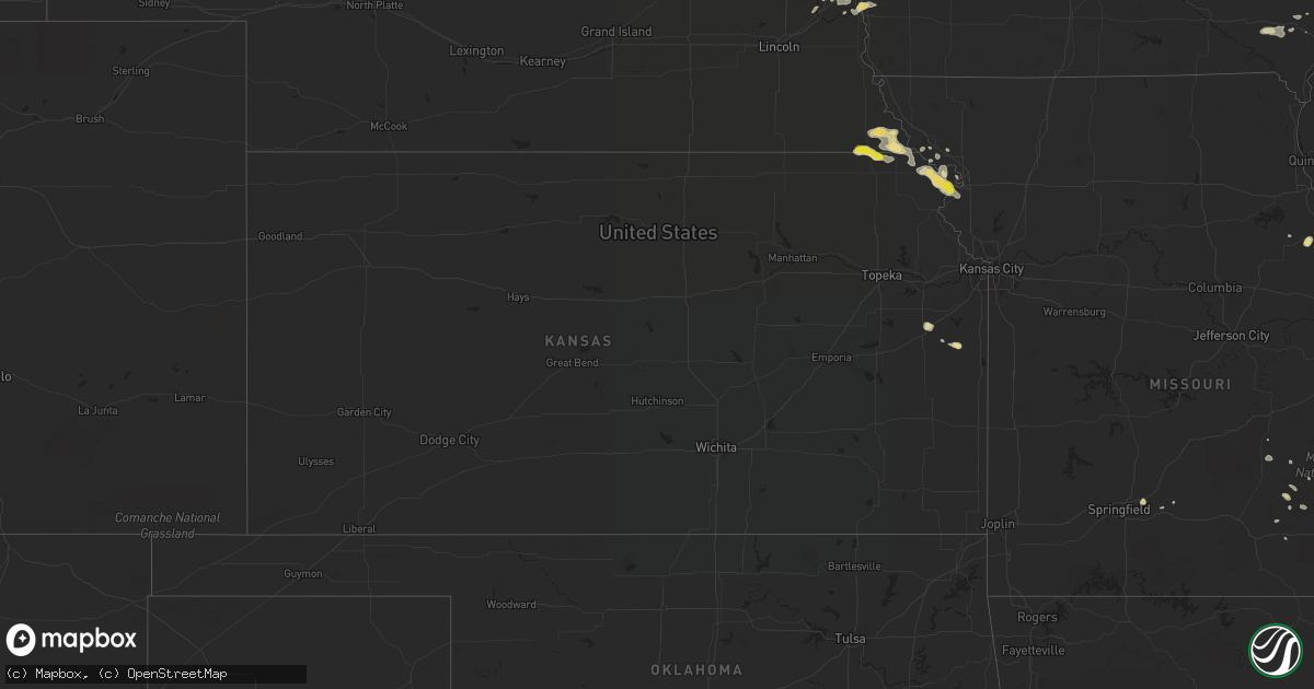
Hail Map in Kansas on June 9, 2018
Get this storm
June 9 map
$229
one time, instant access
Download today. No call, no setup
Keep the $229
Bought the map and want the full workflow? Apply the entire $229 to a subscription within 7 days. None of it is wasted.
Every map, not just this one
This buys you this map. Subscription and you get every map we run, in the markets you choose from a few cities to whole states to nationwide. Plus real-time alerts the moment a storm fires.
Contact data
Name, contact info, occupancy, even credit band for addresses in the footprint. You go from where it hit to who to call.
Become the source they trust
Unlimited branding weather history reports on demand. You already have the documented answer ready for the property owner, and you are the one who showed up with it.
Property data and RoofTrace estimates
Pull up any address you have got, its value and the exact code rules for that jurisdiction, straight from One Click Code. Then RoofTrace estimates the squares, pitch, and roof value, priced the way you price.
Storm reports in Kansas
Kansas
| Date | Description |
|---|---|
| 06/09/20182:56 AM CDT | At 755 PM CDT, a severe thunderstorm was located near Troy, moving southeast at 30 mph. HAZARD...70 mph wind gusts and quarter size hail. SOURCE...Radar indicated. At 754 PM CDT a tree and powerpole were reported down in Oregon, MO. IMPACT...Hail damage to vehicles is expected. Expect considerable tree damage. Wind damage is also likely to mobile homes, roofs, and outbuildings. Locations impacted include... St. Joseph, Savannah, Wathena, Elwood, Highland, Troy, Country Club Villa, Country Club, Amazonia, Denton, Severance, Leona, St. Joseph Airport, Bendena and Fanning.This includes the following highways... Interstate 29 between mile markers 53 and 71. Interstate 229 between mile markers 7 and 14. |
| 06/09/20182:29 AM CDT | At 726 PM CDT, a severe thunderstorm was located 6 miles north of Sabetha, moving east at 20 mph. HAZARD...60 mph wind gusts and quarter size hail. SOURCE...Radar indicated. IMPACT...Hail damage to vehicles is expected. Expect wind damage to roofs, siding, and trees. Locations impacted include... Sabetha, Morrill and Hamlin. |
| 06/09/20181:49 AM CDT | At 649 PM CDT, a severe thunderstorm was located 7 miles northeast of Bern, or 9 miles north of Sabetha, moving east at 10 mph. HAZARD...60 mph wind gusts and quarter size hail. SOURCE...Radar indicated. IMPACT...Hail damage to vehicles is expected. Expect wind damage to roofs, siding, and trees. Locations impacted include... Falls City, Humboldt, Verdon, Stella, Shubert, Rulo, Dawson, Salem, Preston, Barada, The Highway 75 And 8 Junction and Camp Cornhusker. |
| 06/08/201810:03 PM CDT | At 302 AM CDT, severe thunderstorm outflow was located along a line extending from near Lawrence to Riverton to near Harlan County Dam, moving southeast at 30 mph. HAZARD...60 mph wind gusts. SOURCE...Radar indicated. In addition, at 242 AM CDT, an off duty NWS employee estimated 60 MPH winds two miles north of Pauline in Adams County. IMPACT...Expect damage to roofs, siding, and trees. Locations impacted include... Phillipsburg, Smith Center, Red Cloud, Franklin, Kensington, Agra, Guide Rock, Lebanon, Burr Oak, Republican City, Naponee, Bloomington, Esbon, Glade, Riverton, Athol, Cowles, Inavale, Bellaire and Harlan County Dam. |
| 06/08/201810:00 PM CDT | At 259 AM CDT, severe thunderstorm outflow winds were located along a line extending from near Lawrence to near Davenport to near Friend, moving south at 45 mph. HAZARD...60 mph wind gusts. SOURCE...Radar indicated. In addition, airports at Hastings, Aurora and York have all gusted to at least 59 MPH during the past hour. IMPACT...Expect damage to roofs, siding, and trees. Locations impacted include... Geneva, Superior, Hebron, Mankato, Deshler, Exeter, Edgar, Nelson, Shickley, Davenport, Milligan, Bruning, Chester, Alexandria, Hardy, Ruskin, Ohiowa, Carleton, Byron and Oak. |
| 06/08/20188:15 PM CDT | Estimated winds of 40 to 50 mph with gusts of 60 to 70 mph. Pea-sized hail. |
All States Impacted by Hail Map on June 9, 2018
Cities Impacted by Hail Map on June 9, 2018
- Spring Grove, MN
- Decorah, IA
- Mabel, MN
- Winchester, VA
- Clear Brook, VA
- Stephens City, VA
- White Post, VA
- Pierson, IA
- Anthon, IA
- Correctionville, IA
- Moville, IA
- Mosquero, NM
- Moselle, MS
- Ellisville, MS
- Ellendale, MN
- Clarks Grove, MN
- Hartland, MN
- Albert Lea, MN
- Alden, MN
- Oneonta, AL
- Norway, IA
- Marengo, IA
- Blairstown, IA
- Watkins, IA
- Falls City, NE
- Geneva, IA
- Hampton, IA
- Fertile, IA
- Clear Lake, IA
- Hanlontown, IA
- Manly, IA
- Mason City, IA
- Preston, IA
- Atkinson, IL
- Cambridge, IL
- Kewanee, IL
- Chenoa, IL
- Pontiac, IL
- Edinburg, VA
- Shorterville, AL
- Abbeville, AL
- Newville, AL
- Mount Auburn, IA
- Vinton, IA
- Ottawa, KS
- Prosperity, SC
- Little Mountain, SC
- Chapin, SC
- Moores Hill, IN
- Aurora, IN
- Iowa City, IA
- Keswick, IA
- Barnes City, IA
- What Cheer, IA
- Gibson, IA
- Lawton, IA
- Papillion, NE
- Omaha, NE
- Springfield, NE
- La Vista, NE
- Chatsworth, IL
- Roberts, IL
- Thawville, IL
- Alexander, IA
- Latimer, IA
- Coulter, IA
- Dupo, IL
- Columbia, IL
- East Carondelet, IL
- Washington, IA
- Iowa Falls, IA
- Ackley, IA
- Sidell, IL
- Indianola, IL
- Fairmount, IL
- Offutt Afb, NE
- Bellevue, NE
- Montour, IA
- Toledo, IA
- Garwin, IA
- Bixby, MO
- Montevallo, AL
- Easton, MN
- Delavan, MN
- Georgetown, MN
- Argusville, ND
- Carroll, IA
- Breda, IA
- Cedar Rapids, IA
- Humboldt, IL
- Charleston, IL
- Mattoon, IL
- Sheffield, IA
- Dougherty, IA
- Creighton, NE
- Royal, NE
- Winnetoon, NE
- Brunswick, NE
- Charter Oak, IA
- Gillette, WY
- Dana, IL
- Benson, IL
- Minonk, IL
- Chinook, MT
- Harlem, MT
- Salem, NE
- Morrill, KS
- Dawson, NE
- Sabetha, KS
- Odell, IL
- Dwight, IL
- Emington, IL
- Homer, IL
- Saint Joseph, IL
- Sidney, IL
- Heathsville, VA
- Kilmarnock, VA
- Cologne, MN
- Chaska, MN
- Carver, MN
- Morton, MS
- Amana, IA
- Avon, SD
- Hall, MT
- Philipsburg, MT
- Drummond, MT
- Corvallis, MT
- Rudd, IA
- Marble Rock, IA
- Greene, IA
- Charles City, IA
- Nora Springs, IA
- Rockford, IA
- Tinnie, NM
- Salem, IL
- Odin, IL
- Wellman, IA
- Curryville, MO
- Vandalia, MO
- Salem, MO
- Tallahassee, FL
- Keystone Heights, FL
- Brayton, IA
- Atlantic, IA
- Walnut, IA
- Audubon, IA
- Marne, IA
- Kimballton, IA
- Harlan, IA
- Elk Horn, IA
- Exira, IA
- Keystone, IA
- Van Horne, IA
- Elberon, IA
- Buckatunna, MS
- Glenville, MN
- Tripp, SD
- Scotland, SD
- Craig, MO
- Sullivan, IN
- Merom, IN
- Marshfield, MO
- Seymour, MO
- Laurel Hill, FL
- Crestview, FL
- South English, IA
- Webster, IA
- North English, IA
- Monticello, IL
- Wellsburg, IA
- Thurston, NE
- Pender, NE
- Emerson, NE
- Wakefield, NE
- Tipton, IA
- Wadena, IA
- Fayette, IA
- Rochester, IL
- Pecos, TX
- Kensett, IA
- Moccasin, MT
- Stanford, MT
- Wells, MN
- Denton, MT
- Winifred, MT
- French Lick, IN
- Paoli, IN
- Verdigre, NE
- Odebolt, IA
- Scotia, NE
- Gladstone, VA
- Arlington, IA
- Volga, IA
- Alzada, MT
- Belle Fourche, SD
- Niobrara, NE
- Otter, MT
- Tappahannock, VA
- Covington, IN
- Onawa, IA
- Whiting, IA
- Griggsville, IL
- Hammond, MT
- Harmony, MN
- Cresco, IA
- Shipman, IL
- Brighton, IL
- Vienna, MD
- Waynesville, OH
- Roodhouse, IL
- Greenfield, IL
- Frost, MN
- Bricelyn, MN
- Astoria, IL
- Rushville, IL
- Laurel, NE
- Dixon, NE
- North Henderson, IL
- Rio, IL
- Dysart, IA
- Parnell, IA
- Saint Louis, MO
- Chambers, NE
- Georgetown, IL
- Ridge Farm, IL
- Mobile, AL
- Monroe, NE
- Columbus, NE
- Platte Center, NE
- Genoa, NE
- Palestine, IL
- Jordan, MN
- Strafford, MO
- Humboldt, NE
- Hiawatha, KS
- Bern, KS
- Centralia, IL
- Sandoval, IL
- Hoyleton, IL
- Gurdon, AR
- Emmons, MN
- Northwood, IA
- Hayward, MN
- Shellsburg, IA
- Urbana, IA
- Dodge, NE
- Rogers, NE
- Weems, VA
- Lancaster, VA
- Hillsboro, ND
- Parkersburg, IA
- Homestead, IA
- Eldora, IA
- Forest City, IA
- Leland, IA
- La Porte City, IA
- Jesup, IA
- Alamo, TN
- Hollandale, MN
- Crofton, NE
- Kingsley, IA
- Bronson, IA
- Troy, KS
- Hettick, IL
- Elk Point, SD
- Jefferson, SD
- Conchas Dam, NM
- Ohatchee, AL
- Hoopeston, IL
- Rankin, IL
- Wellington, IL
- Bismarck, MO
- Doe Run, MO
- Ironton, MO
- Plymouth, IL
- Macomb, IL
- Littleton, IL
- Industry, IL
- Bluffs, IL
- Chapin, IL
- Arenzville, IL
- Versailles, IL
- Jacksonville, IL
- Meredosia, IL
- Beardstown, IL
- Mount Sterling, IL
- Chambersburg, IL
- Downs, IL
- Bloomington, IL
- Mason, IL
- Watson, IL
- Edgewood, IL
- Hutsonville, IL
- Robinson, IL
- Allen, NE
- Hartington, NE
- Augusta, WV
- Delray, WV
- Cissna Park, IL
- Milford, IL
- Upland, IN
- Hartford City, IN
- Montpelier, IN
- Grundy Center, IA
- Frisco City, AL
- Middletown, VA
- Birmingham, AL
- Bessemer, AL
- Golden Gate, IL
- Coffee Creek, MT
- Janesville, IA
- Waterloo, IA
- Cedar Falls, IA
- Waverly, IA
- New Hartford, IA
- Granite City, IL
- Bird Island, MN
- Morton, MN
- Franklin, MN
- Cherokee, IA
- Lake Mills, IA
- Thompson, IA
- Belle Plaine, MN
- Henderson, MN
- Le Sueur, MN
- West Union, IA
- Walthill, NE
- Marion Junction, AL
- Buena Vista, GA
- Bloomfield, NE
- Fordyce, NE
- Lloyd, MT
- Muncie, IN
- Blakely, GA
- Ryan, IA
- Manchester, IA
- Fort Washington, MD
- Accokeek, MD
- Waterloo, IL
- Valmeyer, IL
- Fults, IL
- Headland, AL
- Ozark, AL
- Yazoo City, MS
- Joice, IA
- Amelia, NE
- Vermont, IL
- Browning, IL
- Independence, IA
- Millville, NJ
- Bridgeton, NJ
- Cambridge, MD
- Rhodesdale, MD
- Goose Lake, IA
- Bryant, IA
- Charlotte, IA
- Gladbrook, IA
- Reinbeck, IA
- Neligh, NE
- Tuskegee, AL
- Chelsea, IA
- Clutier, IA
- Stockport, IA
- Lockridge, IA
- Clifton, VA
- Prairie, MS
- Lakeland, GA
- Naylor, GA
- Altona, IL
- Galva, IL
- Bishop Hill, IL
- Semmes, AL
- Wathena, KS
- Bonne Terre, MO
- Fairfield, IA
- Greeley, NE
- Osawatomie, KS
- Seaford, DE
- Bethel, DE
- Atkins, IA
- Palo, IA
- Vining, IA
- Belle Plaine, IA
- Luzerne, IA
- Newhall, IA
- Walford, IA
- Fairfax, IA
- South Amana, IA
- Swisher, IA
- Hiawatha, IA
- Ladora, IA
- North Liberty, IA
- Middle Amana, IA
- Victor, IA
- Oxford, IA
- Gaston, IN
- Atwood, IL
- Arthur, IL
- Lovington, IL
- Highland, KS
- Bendena, KS
- Hogeland, MT
- Monroe, VA
- Madison Heights, VA
- Thomson, IL
- Chadwick, IL
- Morrison, IL
- Milledgeville, IL
- Fulton, IL
- Albion, NE
- Primrose, NE
- Gardner, ND
- Strawberry Point, IA
- Waterbury, NE
- Hubbard, NE
- Jackson, NE
- Tama, IA
- Carlyle, IL
- England, AR
- Enterprise, AL
- Rowley, IA
- Le Center, MN
- Woodbine, IA
- Albany, IL
- Hillsdale, IL
- Camden, AL
- Alberta, AL
- Catherine, AL
- Pine Hill, AL
- Bryant, IN
- Pennville, IN
- Dunkirk, IN
- Osage, IA
- Stanley, IA
- Hays, MT
- Adair, IL
- Upper Marlboro, MD
- Aladdin, WY
- Ericson, NE
- Ord, NE
- Burwell, NE
- Martinsville, IL
- Casey, IL
- Big Sandy, MT
- Pacific Junction, IA
- Council Bluffs, IA
- Glenwood, IA
- Prattville, AL
- Concord, IL
- Holt, FL
- La Fayette, IL
- Claude, TX
- Capitol, MT
- Hulett, WY
- Dike, IA
- Dozier, AL
- Perry, IL
- Winchester, IL
- Ambrose, GA
- Broxton, GA
- Ponca, NE
- Westfield, IA
- Alpha, IL
- Mineral, VA
- Troy, AL
- Jack, AL
- Temple Hills, MD
- Suitland, MD
- Mechanicsburg, OH
- Wickliffe, KY
- Charleston, MO
- Moss Point, MS
- Bunker, MO
- Warwick, GA
- Sylvester, GA
- Lime Springs, IA
- Chester, IA
- Princeton, IL
- Buda, IL
- Sheffield, IL
- Tiskilwa, IL
- Wyanet, IL
- Bowen, IL
- Augusta, IL
- Huntsville, IL
- Patoka, IL
- Bartelso, IL
- Hoffman, IL
- Kell, IL
- Williamsport, IN
- Middletown, IN
- Winthrop, IA
- Quasqueton, IA
- Hazleton, IA
- Masonville, IA
- Fairbank, IA
- Rantoul, IL
- Mount Pleasant, IA
- Concord, NE
- Riceville, IA
- Sterling, IL
- Gretna, NE
- Marion, IN
- Saraland, AL
- Chunchula, AL
- Bellwood, NE
- Randolph, NE
- Coleridge, NE
- Perry, MO
- Eminence, MO
- Carlisle, IN
- Guernsey, IA
- Verdon, NE
- Sacred Heart, MN
- Olivia, MN
- Grinnell, IA
- Gilman, IA
- Remsen, IA
- Marcus, IA
- Stonington, IL
- New Madison, OH
- Arcanum, OH
- Oregon, MO
- Five Points, AL
- Roanoke, AL
- Shirley, IL
- McLean, IL
- Columbus, GA
- Mclean, NE
- Rockwell, IA
- Monmouth, IL
- Theodore, AL
- Irvington, AL
- Grand Bay, AL
- Fredericksburg, IA
- New Hampton, IA
- Sumner, IA
- Frederika, IA
- Tripoli, IA
- Nashua, IA
- Ionia, IA
- Floyd, IA
- Prince Frederick, MD
- Huntingtown, MD
- Humphrey, NE
- Alexandria, VA
- Park Hills, MO
- Irondale, MO
- Aplington, IA
- Wabash, IN
- Taylorville, IL
- Paola, KS
- Opp, AL
- Walnut, IL
- Tampico, IL
- Hamilton, GA
- Saint Joseph, MO
- Paxton, IL
- Mount Olive, IL
- Klemme, IA
- Swaledale, IA
- Thornton, IA
- Seaton, IL
- Aledo, IL
- Alexis, IL
- Viola, IL
- Traer, IA
- Blomkest, MN
- Milton, FL
- Steamboat Rock, IA
- Tyndall, SD
- Dieterich, IL
- Irwin, IA
- Defiance, IA
- Le Roy, IL
- White Cloud, KS
- Robinson, KS
- Rulo, NE
- Lindsay, NE
- Saint Edward, NE
- Amherst, VA
- Alma, GA
- Mankato, MN
- Janesville, MN
- Saint Clair, MN
- Elma, IA
- Westgate, IA
- Saint Ansgar, IA
- Plymouth, IA
- Plainfield, IA
- Ventura, IA
- Allison, IA
- Garner, IA
- Scarville, IA
- Grafton, IA
- Bristow, IA
- Clarksville, IA
- Little Cedar, IA
- Plattsmouth, NE
- Lonoke, AR
- Olin, IA
- Anamosa, IA
- Assumption, IL
- Moweaqua, IL
- De Soto, MO
- Saint Olaf, IA
- Louisville, NE
- Hillsdale, IN
- Dana, IN
- Dunkerton, IA
- Streator, IL
- Greenville, OH
- Cairo, IL
- Rison, AR
- Smithville, GA
- Marianna, FL
- Altha, FL
- Mapleton, MN
- Darfur, MN
- The Plains, VA
- Red Bud, IL
- Cullom, IL
- Rolla, MO
- Eight Mile, AL
- Geneva, MN
- Blooming Prairie, MN
- Saunemin, IL
- Fairbury, IL
- Forrest, IL
- Farmington, MO
- Altoona, AL
- Portland, IN
- Aurora, IA
- Brandon, IA
- Coggon, IA
- Walker, IA
- Normal, IL
- Cut Bank, MT
- Erie, IL
- Ellsworth, IL
- Hot Springs National Park, AR
- New Sharon, IA
- Deep River, IA
- Clinton, MD
- District Heights, MD
- Columbus Junction, IA
- New Brockton, AL
- Maynard, MN
- Montevideo, MN
- West Liberty, IA
- Atalissa, IA
- Sleepy Eye, MN
- Greenville, AL
- Solon, IA
- Mount Vernon, IA
- Lisbon, IA
- Mechanicsville, IA
- Flanagan, IL
- Dugspur, VA
- Knoxville, IL
- Gilson, IL
- Federalsburg, MD
- Denton, MD
- Patoka, IN
- Decker, IN
- Hingham, MT
- Atkinson, NE
- Saint James, MN
- De Witt, IA
- Clinton, IA
- Valdosta, GA
- Adel, GA
- Hahira, GA
- Ray City, GA
- Georgetown, DE
- Dewey, IL
- Mount Erie, IL
- Albion, IL
- West Salem, IL
- Black, MO
- Birch Tree, MO
- Holland, IA
- Fort Benton, MT
- Chesterfield, IL
- Palmyra, IL
- Petal, MS
- Ovett, MS
- Magnet, NE
- Fieldon, IL
- Macy, NE
- Strawn, IL
- Fertile, MN
- Springfield, MN
- Denison, IA
- Lafayette, AL
- Cataula, GA
- Table Grove, IL
- Colchester, IL
- Camden, IL
- Wilmer, AL
- Argenta, IL
- Arabi, GA
- Philo, IL
- Urbana, IL
- Bainbridge, OH
- Hardin, IL
- Andrews Air Force Base, MD
- Brandywine, MD
- Capitol Heights, MD
- Blue Earth, MN
- Winnebago, MN
- Moscow, IA
- Halls, TN
- Mark, IL
- Granville, IL
- Keota, IA
- Sigourney, IA
- Harper, IA
- Kingman, IN
- Hudson, IA
- Flat Rock, IL
- Annapolis, IL
- West York, IL
- Lynchburg, VA
- Marbury, AL
- Soldier, IA
- Wataga, IL
- Galesburg, IL
- Herculaneum, MO
- Festus, MO
- Pevely, MO
- Wagarville, AL
- Forest Home, AL
- West Branch, IA
- Woodford, VA
- Spotsylvania, VA
- O'Fallon, MO
- Lexington, MS
- Rantoul, KS
- Delaplane, VA
- Okolona, MS
- Kalispell, MT
- Auburn, IA
- Muscatine, IA
- Vancleave, MS
- Gildford, MT
- Decatur, NE
- Alvin, IL
- Henning, IL
- Rossville, IL
- Potomac, IL
- Williamsburg, IA
- Riverside, IA
- Kalona, IA
- Clarence, IA
- Hills, IA
- Stanwood, IA
- Bath, IL
- Clayton, DE
- Dover, DE
- Smyrna, DE
- Jefferson, NC
- Laurel Springs, NC
- High View, WV
- Gore, VA
- Glenwood, GA
- Alamo, GA
- Clearwater, NE
- Elgin, NE
- Bismarck, IL
- Danville, IL
- Solano, NM
- Americus, GA
- Honoraville, AL
- Warsaw, VA
- Bradford, IA
- Alden, IA
- Champaign, IL
- Waynesboro, MS
- Loma, MT
- Midland, GA
- Hope, ND
- Vail, IA
- Bowman, ND
- Austin, MN
- Lawler, IA
- Buckley, IL
- Forest City, MO
- Owings, MD
- Immokalee, FL
- Champlain, VA
- Callao, VA
- Dunnsville, VA
- Farnham, VA
- Leadwood, MO
- Summerdale, AL
- Ewing, NE
- Monticello, FL
- Felda, FL
- Durant, IA
- Bennett, IA
- Wilton, IA
- New Liberty, IA
- Eaton, IN
- Bard, NM
- Hedrick, IA
- Kempton, IL
- Ashkum, IL
- Crescent, IA
- Pomaria, SC
- Chrisman, IL
- Solomons, MD
- Irvine, KY
- Romney, WV
- Box Elder, MT
- Salem, IA
- North Bend, NE
- De Soto, IL
- Carterville, IL
- Live Oak, FL
- McAlpin, FL
- Woodlawn, VA
- Buffalo, SD
- Arcola, IL
- Tuscola, IL
- Hartshorn, MO
- Cuero, TX
- Sioux City, IA
- Sergeant Bluff, IA
- Oelwein, IA
- Rutland, IL
- Sibley, IL
- Melvin, IL
- Piper City, IL
- Graymont, IL
- Heyworth, IL
- Cuthbert, GA
- Twin Valley, MN
- Farmer City, IL
- Maroa, IL
- Nicholls, GA
- Ely, IA
- Brandon, MS
- Hooper, NE
- Blountsville, AL
- Lewisville, MN
- Atchison, KS
- Wellborn, FL
- Malcom, IA
- Brooklyn, IA
- Oneida, IL
- Woodhull, IL
- Toulon, IL
- Wyoming, IL
- Mineral Point, MO
- Shellman, GA
- Choteau, MT
- Ashland, NE
- Bunker Hill, IL
- Gillespie, IL
- Rutledge, AL
- Thomasboro, IL
- Helena, AL
- Bowling Green, MO
- Bement, IL
- Hattiesburg, MS
- Portsmouth, IA
- Geneseo, IL
- Du Bois, NE
- West Alton, MO
- Toledo, IL
- Lone Tree, IA
- Enterprise, MS
- Quitman, MS
- Summersville, MO
- Williamsfield, IL
- Dahinda, IL
- East Saint Louis, IL
- Arnold, MO
- Imperial, MO
- French Village, MO
- Valles Mines, MO
- Rose Hill, MS
- Wausa, NE
- Osmond, NE
- Le Mars, IA
- Saucier, MS
- Jay, FL
- Spalding, NE
- Hennepin, IL
- West Terre Haute, IN
- New Athens, IL
- Mahomet, IL
- Fisher, IL
- Naples, FL
- Lenox, MO
- Edgar Springs, MO
- Licking, MO
- Richland, GA
- Bloomfield, IN
- Bridgeville, DE
- Preston, MD
- Laurel, DE
- Annawan, IL
- Bowling Green, VA
- Tibbie, AL
- Greenville, FL
- Prinsburg, MN
- Cedar Rapids, NE
- Williams, IN
- Wall Lake, IA
- Florissant, MO
- Mentor, MN
- Sweet Grass, MT
- Sunburst, MT
- Mount Union, IA
- Hammond, IL
- Cerro Gordo, IL
- Carmi, IL
- Elberta, AL
- Yellow Spring, WV
- Victoria, IL
- New London, IA
- Florala, AL
- Granite Falls, MN
- Millsboro, DE
- Clara City, MN
- Renville, MN
- Mechanicsburg, IL
- Moody Afb, GA
- Toluca, IL
- Danforth, IL
- McRae Helena, GA
- Cornell, IL
- Louin, MS
- Borup, MN
- Buckingham, IA
- Malmo, NE
- Colon, NE
- Plainview, NE
- Hidalgo, IL
- Prophetstown, IL
- Star Tannery, VA
- Allerton, IL
- Metcalf, IL
- Hume, IL
- Saint Helena, NE
- El Paso, IL
- Wetumpka, AL
- Martelle, IA
- Springville, IA
- Westside, IA
- Arcadia, IA
- Thomasville, AL
- Magee, MS
- Raleigh, MS
- Elgin, IA
- McNabb, IL
- Towanda, IL
- Gifford, IL
- Grafton, IL
- Letts, IA
- Conesville, IA
- Hartly, DE
- Camden Wyoming, DE
- Balmorhea, TX
- Blair, NE
- Belgrade, NE
- Edinburg, IL
- Maurice, LA
- New Prague, MN
- Greenup, IL
- Nashville, GA
- McIntire, IA
- Nickerson, NE
- Carthage, IL
- Trilla, IL
- Lerna, IL
- Anniston, AL
- Wellington, AL
- Newcastle, NE
- Beaman, IA
- Winnebago, NE
- Petersburg, NE
- Schuyler, NE
- Britt, IA
- Goodell, IA
- Hillview, IL
- Patterson, IL
- Galax, VA
- Dante, SD
- Wagner, SD
- Wolbach, NE
- Pawnee, IL
- Riverton, IL
- Springfield, IL
- Labelle, FL
- Alva, FL
- Eldridge, IA
- Le Claire, IA
- Davenport, IA
- Bettendorf, IA
- Broadus, MT
- Lake City, MN
- Zumbro Falls, MN
- Freeborn, MN
- New Richland, MN


