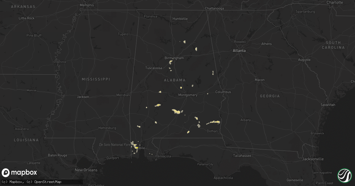
Hail Map in Alabama on June 9, 2018
Get this storm
June 9 map
$229
one time, instant access
Download today. No call, no setup
Keep the $229
Bought the map and want the full workflow? Apply the entire $229 to a subscription within 7 days. None of it is wasted.
Every map, not just this one
This buys you this map. Subscription and you get every map we run, in the markets you choose from a few cities to whole states to nationwide. Plus real-time alerts the moment a storm fires.
Contact data
Name, contact info, occupancy, even credit band for addresses in the footprint. You go from where it hit to who to call.
Become the source they trust
Unlimited branding weather history reports on demand. You already have the documented answer ready for the property owner, and you are the one who showed up with it.
Property data and RoofTrace estimates
Pull up any address you have got, its value and the exact code rules for that jurisdiction, straight from One Click Code. Then RoofTrace estimates the squares, pitch, and roof value, priced the way you price.
Storm reports in Alabama
Alabama
| Date | Description |
|---|---|
| 06/09/20186:50 PM CDT | Trees and power lines down near s shawdee road and nature trail road. |
| 06/09/20186:45 PM CDT | Multiple trees and power lines down on mountain gap road between chesterfield drive and brandywine drive; and near greenleaf circle and greenleaf drive intersection. |
| 06/09/20184:26 PM CDT | Multiple trees down in the county. |
| 06/09/20183:22 PM CDT | Tree down. |
| 06/09/20183:22 PM CDT | Tree down. |
| 06/09/20183:13 PM CDT | Tree down over the roadway near the corner of old shell rd near ridgelawn dr. E. Time estimated by radar. |
| 06/09/20183:07 PM CDT | One inch hail reported at the university of south alabama from numerous pictures and video on social media. |
| 06/09/20183:07 PM CDT | Broadcast media relayed picture of roughly half dollar size hail at the corner of hillcrest and airport blvd. Time estimated from radar data |
| 06/09/20182:55 PM CDT | Tree down. |
| 06/09/20182:41 PM CDT | Tree and powerline down. |
| 06/09/20184:16 AM CDT | At 915 PM CDT, a severe thunderstorm was located near Ohatchee, or 8 miles northwest of Saks, moving southeast at 15 mph. HAZARD...60 mph wind gusts. SOURCE...Radar indicated. IMPACT...Expect damage to roofs, siding, and trees. Locations impacted include... Anniston, Fort McClellan, Saks, West End-Cobb Town, Glencoe, Weaver, Ragland, Ohatchee, Blue Mountain, Alexandria, Neely Henry Lake, Southside, Neely Henry Dam, Sulphur Springs and Wellington. |
| 06/09/201812:09 AM CDT | At 509 PM CDT, a severe thunderstorm was located over Greenville, moving west at 5 to 10 mph. HAZARD...60 mph wind gusts and quarter size hail. SOURCE...Radar indicated. IMPACT...Hail damage to vehicles is expected. Expect wind damage to roofs, siding, and trees. Locations impacted include... Greenville. |
| 06/08/201811:22 PM CDT | At 422 PM CDT, a severe thunderstorm was located near New Brockton, or near Elba, and is nearly stationary. HAZARD...60 mph wind gusts and penny size hail. SOURCE...Radar indicated. IMPACT...Expect damage to roofs, siding, and trees. Locations impacted include... Elba, Enterprise, Fort Rucker, New Brockton, Kinston, Perry Store, Curtis, Carl Folsom A/p, Lucile, Ino, Turner Crossroads, Central City, Clintonville, Goodman, Camp Alaflo Bsa, Basin, Enterprise Municipal A/P, Woodland Grove Church, Alberton and Richburg. |
| 06/08/201810:59 PM CDT | At 358 PM CDT, a severe thunderstorm was located near Davisville, or 7 miles southeast of Tuskegee, and is nearly stationary. HAZARD...60 mph wind gusts and penny size hail. SOURCE...Radar indicated. IMPACT...Expect damage to roofs, siding, and trees. Locations impacted include... Tuskegee, Davisville, Warriorstand and Fort Davis. |
| 06/08/201810:53 PM CDT | At 353 PM CDT, a severe thunderstorm was located 11 miles south of Antioch, or 11 miles southwest of Brundidge, and is nearly stationary. HAZARD...60 mph wind gusts and penny size hail. SOURCE...Radar indicated. IMPACT...Expect damage to roofs, siding, and trees. Locations impacted include... Fort Rucker, Lee, Java, Chestnut Grove, Mixons Crossroads, Victoria, Frisco, Eanon, Lowry Mill, Wilkinstown, Camp Humming Hills, Wise Mill, Roeton, Clowers Crossroads, Arcus, Bluff Spring, Jack and Zoar. |
| 06/08/201810:44 PM CDT | At 344 PM CDT, a severe thunderstorm was located 5 miles south of Opp, moving northeast at 15 mph. HAZARD...60 mph wind gusts and quarter size hail. SOURCE...Radar indicated. IMPACT...Hail damage to vehicles is expected. Expect wind damage to roofs, siding, and trees. Locations impacted include... Opp. |
| 06/08/201810:09 PM CDT | At 308 PM CDT, a severe thunderstorm was located 7 miles east of Ozark, and is nearly stationary. HAZARD...60 mph wind gusts and penny size hail. SOURCE...Radar indicated. IMPACT...Expect damage to roofs, siding, and trees. Locations impacted include... Ozark, Fort Rucker, Newton, Pinckard, Bells Crossroads, Hunt Field, Waterford, Dill, Mabson, Snells Crossroads, Ewell, Dale County Lake, Marley Hill, Skipperville, Echo, Dean Church Road, Bagwells Crossroads, Kelly, Barefield Crossroads and Beamon. |
| 06/08/20189:50 PM CDT | At 250 PM CDT, a severe thunderstorm was located near Mobile Regional Airport, or 4 miles northwest of Tillmans Corner, moving southeast at 20 mph. HAZARD...60 mph wind gusts and nickel size hail. SOURCE...Radar indicated. IMPACT...Expect damage to roofs, siding, and trees. Locations impacted include... Midtown Mobile, Tillmans Corner, Tanner Williams and Mobile Regional Airport. |
| 06/08/20189:41 PM CDT | At 240 PM CDT, a severe thunderstorm was located near Abbeville, moving southeast at 10 mph. HAZARD...60 mph wind gusts and penny size hail. SOURCE...Radar indicated. IMPACT...Expect damage to roofs, siding, and trees. Locations impacted include... Abbeville, Headland, Newville, Bells Crossroads, Tumbleton, Echo, Kirkland Crossroads, Blackwood, Capps, Snells Crossroads, Barefield Crossroads, Murphy Station, Goldberg Field, Headland Municipal A/P, Dancey, Bertha and Balkum. |
| 06/08/20189:32 PM CDT | At 231 PM CDT, a severe thunderstorm was located over Semmes, or 8 miles west of Chickasaw, and is nearly stationary. HAZARD...60 mph wind gusts and nickel size hail. SOURCE...Radar indicated. IMPACT...Expect damage to roofs, siding, and trees. Locations impacted include... Semmes and Wilmer. |
| 06/08/20188:22 PM CDT | Several trees down on airport road near oneonta. |
| 06/08/20188:14 PM CDT | Trees down blocking tyler loop road in center point. |
| 06/08/20188:03 PM CDT | Several trees down near hopewell road and nixon road in bessemer. |
| 06/08/20188:03 PM CDT | Trees and powerlines down on headrick road in bessemer. |
| 06/08/20187:47 PM CDT | Several trees down on johns road. |
| 06/08/20187:14 PM CDT | Tree down on mobile home along bessemer superhighway. |
All States Impacted by Hail Map on June 9, 2018
Cities Impacted by Hail Map on June 9, 2018
- Spring Grove, MN
- Decorah, IA
- Mabel, MN
- Winchester, VA
- Clear Brook, VA
- Stephens City, VA
- White Post, VA
- Pierson, IA
- Anthon, IA
- Correctionville, IA
- Moville, IA
- Mosquero, NM
- Moselle, MS
- Ellisville, MS
- Ellendale, MN
- Clarks Grove, MN
- Hartland, MN
- Albert Lea, MN
- Alden, MN
- Oneonta, AL
- Norway, IA
- Marengo, IA
- Blairstown, IA
- Watkins, IA
- Falls City, NE
- Geneva, IA
- Hampton, IA
- Fertile, IA
- Clear Lake, IA
- Hanlontown, IA
- Manly, IA
- Mason City, IA
- Preston, IA
- Atkinson, IL
- Cambridge, IL
- Kewanee, IL
- Chenoa, IL
- Pontiac, IL
- Edinburg, VA
- Shorterville, AL
- Abbeville, AL
- Newville, AL
- Mount Auburn, IA
- Vinton, IA
- Ottawa, KS
- Prosperity, SC
- Little Mountain, SC
- Chapin, SC
- Moores Hill, IN
- Aurora, IN
- Iowa City, IA
- Keswick, IA
- Barnes City, IA
- What Cheer, IA
- Gibson, IA
- Lawton, IA
- Papillion, NE
- Omaha, NE
- Springfield, NE
- La Vista, NE
- Chatsworth, IL
- Roberts, IL
- Thawville, IL
- Alexander, IA
- Latimer, IA
- Coulter, IA
- Dupo, IL
- Columbia, IL
- East Carondelet, IL
- Washington, IA
- Iowa Falls, IA
- Ackley, IA
- Sidell, IL
- Indianola, IL
- Fairmount, IL
- Offutt Afb, NE
- Bellevue, NE
- Montour, IA
- Toledo, IA
- Garwin, IA
- Bixby, MO
- Montevallo, AL
- Easton, MN
- Delavan, MN
- Georgetown, MN
- Argusville, ND
- Carroll, IA
- Breda, IA
- Cedar Rapids, IA
- Humboldt, IL
- Charleston, IL
- Mattoon, IL
- Sheffield, IA
- Dougherty, IA
- Creighton, NE
- Royal, NE
- Winnetoon, NE
- Brunswick, NE
- Charter Oak, IA
- Gillette, WY
- Dana, IL
- Benson, IL
- Minonk, IL
- Chinook, MT
- Harlem, MT
- Salem, NE
- Morrill, KS
- Dawson, NE
- Sabetha, KS
- Odell, IL
- Dwight, IL
- Emington, IL
- Homer, IL
- Saint Joseph, IL
- Sidney, IL
- Heathsville, VA
- Kilmarnock, VA
- Cologne, MN
- Chaska, MN
- Carver, MN
- Morton, MS
- Amana, IA
- Avon, SD
- Hall, MT
- Philipsburg, MT
- Drummond, MT
- Corvallis, MT
- Rudd, IA
- Marble Rock, IA
- Greene, IA
- Charles City, IA
- Nora Springs, IA
- Rockford, IA
- Tinnie, NM
- Salem, IL
- Odin, IL
- Wellman, IA
- Curryville, MO
- Vandalia, MO
- Salem, MO
- Tallahassee, FL
- Keystone Heights, FL
- Brayton, IA
- Atlantic, IA
- Walnut, IA
- Audubon, IA
- Marne, IA
- Kimballton, IA
- Harlan, IA
- Elk Horn, IA
- Exira, IA
- Keystone, IA
- Van Horne, IA
- Elberon, IA
- Buckatunna, MS
- Glenville, MN
- Tripp, SD
- Scotland, SD
- Craig, MO
- Sullivan, IN
- Merom, IN
- Marshfield, MO
- Seymour, MO
- Laurel Hill, FL
- Crestview, FL
- South English, IA
- Webster, IA
- North English, IA
- Monticello, IL
- Wellsburg, IA
- Thurston, NE
- Pender, NE
- Emerson, NE
- Wakefield, NE
- Tipton, IA
- Wadena, IA
- Fayette, IA
- Rochester, IL
- Pecos, TX
- Kensett, IA
- Moccasin, MT
- Stanford, MT
- Wells, MN
- Denton, MT
- Winifred, MT
- French Lick, IN
- Paoli, IN
- Verdigre, NE
- Odebolt, IA
- Scotia, NE
- Gladstone, VA
- Arlington, IA
- Volga, IA
- Alzada, MT
- Belle Fourche, SD
- Niobrara, NE
- Otter, MT
- Tappahannock, VA
- Covington, IN
- Onawa, IA
- Whiting, IA
- Griggsville, IL
- Hammond, MT
- Harmony, MN
- Cresco, IA
- Shipman, IL
- Brighton, IL
- Vienna, MD
- Waynesville, OH
- Roodhouse, IL
- Greenfield, IL
- Frost, MN
- Bricelyn, MN
- Astoria, IL
- Rushville, IL
- Laurel, NE
- Dixon, NE
- North Henderson, IL
- Rio, IL
- Dysart, IA
- Parnell, IA
- Saint Louis, MO
- Chambers, NE
- Georgetown, IL
- Ridge Farm, IL
- Mobile, AL
- Monroe, NE
- Columbus, NE
- Platte Center, NE
- Genoa, NE
- Palestine, IL
- Jordan, MN
- Strafford, MO
- Humboldt, NE
- Hiawatha, KS
- Bern, KS
- Centralia, IL
- Sandoval, IL
- Hoyleton, IL
- Gurdon, AR
- Emmons, MN
- Northwood, IA
- Hayward, MN
- Shellsburg, IA
- Urbana, IA
- Dodge, NE
- Rogers, NE
- Weems, VA
- Lancaster, VA
- Hillsboro, ND
- Parkersburg, IA
- Homestead, IA
- Eldora, IA
- Forest City, IA
- Leland, IA
- La Porte City, IA
- Jesup, IA
- Alamo, TN
- Hollandale, MN
- Crofton, NE
- Kingsley, IA
- Bronson, IA
- Troy, KS
- Hettick, IL
- Elk Point, SD
- Jefferson, SD
- Conchas Dam, NM
- Ohatchee, AL
- Hoopeston, IL
- Rankin, IL
- Wellington, IL
- Bismarck, MO
- Doe Run, MO
- Ironton, MO
- Plymouth, IL
- Macomb, IL
- Littleton, IL
- Industry, IL
- Bluffs, IL
- Chapin, IL
- Arenzville, IL
- Versailles, IL
- Jacksonville, IL
- Meredosia, IL
- Beardstown, IL
- Mount Sterling, IL
- Chambersburg, IL
- Downs, IL
- Bloomington, IL
- Mason, IL
- Watson, IL
- Edgewood, IL
- Hutsonville, IL
- Robinson, IL
- Allen, NE
- Hartington, NE
- Augusta, WV
- Delray, WV
- Cissna Park, IL
- Milford, IL
- Upland, IN
- Hartford City, IN
- Montpelier, IN
- Grundy Center, IA
- Frisco City, AL
- Middletown, VA
- Birmingham, AL
- Bessemer, AL
- Golden Gate, IL
- Coffee Creek, MT
- Janesville, IA
- Waterloo, IA
- Cedar Falls, IA
- Waverly, IA
- New Hartford, IA
- Granite City, IL
- Bird Island, MN
- Morton, MN
- Franklin, MN
- Cherokee, IA
- Lake Mills, IA
- Thompson, IA
- Belle Plaine, MN
- Henderson, MN
- Le Sueur, MN
- West Union, IA
- Walthill, NE
- Marion Junction, AL
- Buena Vista, GA
- Bloomfield, NE
- Fordyce, NE
- Lloyd, MT
- Muncie, IN
- Blakely, GA
- Ryan, IA
- Manchester, IA
- Fort Washington, MD
- Accokeek, MD
- Waterloo, IL
- Valmeyer, IL
- Fults, IL
- Headland, AL
- Ozark, AL
- Yazoo City, MS
- Joice, IA
- Amelia, NE
- Vermont, IL
- Browning, IL
- Independence, IA
- Millville, NJ
- Bridgeton, NJ
- Cambridge, MD
- Rhodesdale, MD
- Goose Lake, IA
- Bryant, IA
- Charlotte, IA
- Gladbrook, IA
- Reinbeck, IA
- Neligh, NE
- Tuskegee, AL
- Chelsea, IA
- Clutier, IA
- Stockport, IA
- Lockridge, IA
- Clifton, VA
- Prairie, MS
- Lakeland, GA
- Naylor, GA
- Altona, IL
- Galva, IL
- Bishop Hill, IL
- Semmes, AL
- Wathena, KS
- Bonne Terre, MO
- Fairfield, IA
- Greeley, NE
- Osawatomie, KS
- Seaford, DE
- Bethel, DE
- Atkins, IA
- Palo, IA
- Vining, IA
- Belle Plaine, IA
- Luzerne, IA
- Newhall, IA
- Walford, IA
- Fairfax, IA
- South Amana, IA
- Swisher, IA
- Hiawatha, IA
- Ladora, IA
- North Liberty, IA
- Middle Amana, IA
- Victor, IA
- Oxford, IA
- Gaston, IN
- Atwood, IL
- Arthur, IL
- Lovington, IL
- Highland, KS
- Bendena, KS
- Hogeland, MT
- Monroe, VA
- Madison Heights, VA
- Thomson, IL
- Chadwick, IL
- Morrison, IL
- Milledgeville, IL
- Fulton, IL
- Albion, NE
- Primrose, NE
- Gardner, ND
- Strawberry Point, IA
- Waterbury, NE
- Hubbard, NE
- Jackson, NE
- Tama, IA
- Carlyle, IL
- England, AR
- Enterprise, AL
- Rowley, IA
- Le Center, MN
- Woodbine, IA
- Albany, IL
- Hillsdale, IL
- Camden, AL
- Alberta, AL
- Catherine, AL
- Pine Hill, AL
- Bryant, IN
- Pennville, IN
- Dunkirk, IN
- Osage, IA
- Stanley, IA
- Hays, MT
- Adair, IL
- Upper Marlboro, MD
- Aladdin, WY
- Ericson, NE
- Ord, NE
- Burwell, NE
- Martinsville, IL
- Casey, IL
- Big Sandy, MT
- Pacific Junction, IA
- Council Bluffs, IA
- Glenwood, IA
- Prattville, AL
- Concord, IL
- Holt, FL
- La Fayette, IL
- Claude, TX
- Capitol, MT
- Hulett, WY
- Dike, IA
- Dozier, AL
- Perry, IL
- Winchester, IL
- Ambrose, GA
- Broxton, GA
- Ponca, NE
- Westfield, IA
- Alpha, IL
- Mineral, VA
- Troy, AL
- Jack, AL
- Temple Hills, MD
- Suitland, MD
- Mechanicsburg, OH
- Wickliffe, KY
- Charleston, MO
- Moss Point, MS
- Bunker, MO
- Warwick, GA
- Sylvester, GA
- Lime Springs, IA
- Chester, IA
- Princeton, IL
- Buda, IL
- Sheffield, IL
- Tiskilwa, IL
- Wyanet, IL
- Bowen, IL
- Augusta, IL
- Huntsville, IL
- Patoka, IL
- Bartelso, IL
- Hoffman, IL
- Kell, IL
- Williamsport, IN
- Middletown, IN
- Winthrop, IA
- Quasqueton, IA
- Hazleton, IA
- Masonville, IA
- Fairbank, IA
- Rantoul, IL
- Mount Pleasant, IA
- Concord, NE
- Riceville, IA
- Sterling, IL
- Gretna, NE
- Marion, IN
- Saraland, AL
- Chunchula, AL
- Bellwood, NE
- Randolph, NE
- Coleridge, NE
- Perry, MO
- Eminence, MO
- Carlisle, IN
- Guernsey, IA
- Verdon, NE
- Sacred Heart, MN
- Olivia, MN
- Grinnell, IA
- Gilman, IA
- Remsen, IA
- Marcus, IA
- Stonington, IL
- New Madison, OH
- Arcanum, OH
- Oregon, MO
- Five Points, AL
- Roanoke, AL
- Shirley, IL
- McLean, IL
- Columbus, GA
- Mclean, NE
- Rockwell, IA
- Monmouth, IL
- Theodore, AL
- Irvington, AL
- Grand Bay, AL
- Fredericksburg, IA
- New Hampton, IA
- Sumner, IA
- Frederika, IA
- Tripoli, IA
- Nashua, IA
- Ionia, IA
- Floyd, IA
- Prince Frederick, MD
- Huntingtown, MD
- Humphrey, NE
- Alexandria, VA
- Park Hills, MO
- Irondale, MO
- Aplington, IA
- Wabash, IN
- Taylorville, IL
- Paola, KS
- Opp, AL
- Walnut, IL
- Tampico, IL
- Hamilton, GA
- Saint Joseph, MO
- Paxton, IL
- Mount Olive, IL
- Klemme, IA
- Swaledale, IA
- Thornton, IA
- Seaton, IL
- Aledo, IL
- Alexis, IL
- Viola, IL
- Traer, IA
- Blomkest, MN
- Milton, FL
- Steamboat Rock, IA
- Tyndall, SD
- Dieterich, IL
- Irwin, IA
- Defiance, IA
- Le Roy, IL
- White Cloud, KS
- Robinson, KS
- Rulo, NE
- Lindsay, NE
- Saint Edward, NE
- Amherst, VA
- Alma, GA
- Mankato, MN
- Janesville, MN
- Saint Clair, MN
- Elma, IA
- Westgate, IA
- Saint Ansgar, IA
- Plymouth, IA
- Plainfield, IA
- Ventura, IA
- Allison, IA
- Garner, IA
- Scarville, IA
- Grafton, IA
- Bristow, IA
- Clarksville, IA
- Little Cedar, IA
- Plattsmouth, NE
- Lonoke, AR
- Olin, IA
- Anamosa, IA
- Assumption, IL
- Moweaqua, IL
- De Soto, MO
- Saint Olaf, IA
- Louisville, NE
- Hillsdale, IN
- Dana, IN
- Dunkerton, IA
- Streator, IL
- Greenville, OH
- Cairo, IL
- Rison, AR
- Smithville, GA
- Marianna, FL
- Altha, FL
- Mapleton, MN
- Darfur, MN
- The Plains, VA
- Red Bud, IL
- Cullom, IL
- Rolla, MO
- Eight Mile, AL
- Geneva, MN
- Blooming Prairie, MN
- Saunemin, IL
- Fairbury, IL
- Forrest, IL
- Farmington, MO
- Altoona, AL
- Portland, IN
- Aurora, IA
- Brandon, IA
- Coggon, IA
- Walker, IA
- Normal, IL
- Cut Bank, MT
- Erie, IL
- Ellsworth, IL
- Hot Springs National Park, AR
- New Sharon, IA
- Deep River, IA
- Clinton, MD
- District Heights, MD
- Columbus Junction, IA
- New Brockton, AL
- Maynard, MN
- Montevideo, MN
- West Liberty, IA
- Atalissa, IA
- Sleepy Eye, MN
- Greenville, AL
- Solon, IA
- Mount Vernon, IA
- Lisbon, IA
- Mechanicsville, IA
- Flanagan, IL
- Dugspur, VA
- Knoxville, IL
- Gilson, IL
- Federalsburg, MD
- Denton, MD
- Patoka, IN
- Decker, IN
- Hingham, MT
- Atkinson, NE
- Saint James, MN
- De Witt, IA
- Clinton, IA
- Valdosta, GA
- Adel, GA
- Hahira, GA
- Ray City, GA
- Georgetown, DE
- Dewey, IL
- Mount Erie, IL
- Albion, IL
- West Salem, IL
- Black, MO
- Birch Tree, MO
- Holland, IA
- Fort Benton, MT
- Chesterfield, IL
- Palmyra, IL
- Petal, MS
- Ovett, MS
- Magnet, NE
- Fieldon, IL
- Macy, NE
- Strawn, IL
- Fertile, MN
- Springfield, MN
- Denison, IA
- Lafayette, AL
- Cataula, GA
- Table Grove, IL
- Colchester, IL
- Camden, IL
- Wilmer, AL
- Argenta, IL
- Arabi, GA
- Philo, IL
- Urbana, IL
- Bainbridge, OH
- Hardin, IL
- Andrews Air Force Base, MD
- Brandywine, MD
- Capitol Heights, MD
- Blue Earth, MN
- Winnebago, MN
- Moscow, IA
- Halls, TN
- Mark, IL
- Granville, IL
- Keota, IA
- Sigourney, IA
- Harper, IA
- Kingman, IN
- Hudson, IA
- Flat Rock, IL
- Annapolis, IL
- West York, IL
- Lynchburg, VA
- Marbury, AL
- Soldier, IA
- Wataga, IL
- Galesburg, IL
- Herculaneum, MO
- Festus, MO
- Pevely, MO
- Wagarville, AL
- Forest Home, AL
- West Branch, IA
- Woodford, VA
- Spotsylvania, VA
- O'Fallon, MO
- Lexington, MS
- Rantoul, KS
- Delaplane, VA
- Okolona, MS
- Kalispell, MT
- Auburn, IA
- Muscatine, IA
- Vancleave, MS
- Gildford, MT
- Decatur, NE
- Alvin, IL
- Henning, IL
- Rossville, IL
- Potomac, IL
- Williamsburg, IA
- Riverside, IA
- Kalona, IA
- Clarence, IA
- Hills, IA
- Stanwood, IA
- Bath, IL
- Clayton, DE
- Dover, DE
- Smyrna, DE
- Jefferson, NC
- Laurel Springs, NC
- High View, WV
- Gore, VA
- Glenwood, GA
- Alamo, GA
- Clearwater, NE
- Elgin, NE
- Bismarck, IL
- Danville, IL
- Solano, NM
- Americus, GA
- Honoraville, AL
- Warsaw, VA
- Bradford, IA
- Alden, IA
- Champaign, IL
- Waynesboro, MS
- Loma, MT
- Midland, GA
- Hope, ND
- Vail, IA
- Bowman, ND
- Austin, MN
- Lawler, IA
- Buckley, IL
- Forest City, MO
- Owings, MD
- Immokalee, FL
- Champlain, VA
- Callao, VA
- Dunnsville, VA
- Farnham, VA
- Leadwood, MO
- Summerdale, AL
- Ewing, NE
- Monticello, FL
- Felda, FL
- Durant, IA
- Bennett, IA
- Wilton, IA
- New Liberty, IA
- Eaton, IN
- Bard, NM
- Hedrick, IA
- Kempton, IL
- Ashkum, IL
- Crescent, IA
- Pomaria, SC
- Chrisman, IL
- Solomons, MD
- Irvine, KY
- Romney, WV
- Box Elder, MT
- Salem, IA
- North Bend, NE
- De Soto, IL
- Carterville, IL
- Live Oak, FL
- McAlpin, FL
- Woodlawn, VA
- Buffalo, SD
- Arcola, IL
- Tuscola, IL
- Hartshorn, MO
- Cuero, TX
- Sioux City, IA
- Sergeant Bluff, IA
- Oelwein, IA
- Rutland, IL
- Sibley, IL
- Melvin, IL
- Piper City, IL
- Graymont, IL
- Heyworth, IL
- Cuthbert, GA
- Twin Valley, MN
- Farmer City, IL
- Maroa, IL
- Nicholls, GA
- Ely, IA
- Brandon, MS
- Hooper, NE
- Blountsville, AL
- Lewisville, MN
- Atchison, KS
- Wellborn, FL
- Malcom, IA
- Brooklyn, IA
- Oneida, IL
- Woodhull, IL
- Toulon, IL
- Wyoming, IL
- Mineral Point, MO
- Shellman, GA
- Choteau, MT
- Ashland, NE
- Bunker Hill, IL
- Gillespie, IL
- Rutledge, AL
- Thomasboro, IL
- Helena, AL
- Bowling Green, MO
- Bement, IL
- Hattiesburg, MS
- Portsmouth, IA
- Geneseo, IL
- Du Bois, NE
- West Alton, MO
- Toledo, IL
- Lone Tree, IA
- Enterprise, MS
- Quitman, MS
- Summersville, MO
- Williamsfield, IL
- Dahinda, IL
- East Saint Louis, IL
- Arnold, MO
- Imperial, MO
- French Village, MO
- Valles Mines, MO
- Rose Hill, MS
- Wausa, NE
- Osmond, NE
- Le Mars, IA
- Saucier, MS
- Jay, FL
- Spalding, NE
- Hennepin, IL
- West Terre Haute, IN
- New Athens, IL
- Mahomet, IL
- Fisher, IL
- Naples, FL
- Lenox, MO
- Edgar Springs, MO
- Licking, MO
- Richland, GA
- Bloomfield, IN
- Bridgeville, DE
- Preston, MD
- Laurel, DE
- Annawan, IL
- Bowling Green, VA
- Tibbie, AL
- Greenville, FL
- Prinsburg, MN
- Cedar Rapids, NE
- Williams, IN
- Wall Lake, IA
- Florissant, MO
- Mentor, MN
- Sweet Grass, MT
- Sunburst, MT
- Mount Union, IA
- Hammond, IL
- Cerro Gordo, IL
- Carmi, IL
- Elberta, AL
- Yellow Spring, WV
- Victoria, IL
- New London, IA
- Florala, AL
- Granite Falls, MN
- Millsboro, DE
- Clara City, MN
- Renville, MN
- Mechanicsburg, IL
- Moody Afb, GA
- Toluca, IL
- Danforth, IL
- McRae Helena, GA
- Cornell, IL
- Louin, MS
- Borup, MN
- Buckingham, IA
- Malmo, NE
- Colon, NE
- Plainview, NE
- Hidalgo, IL
- Prophetstown, IL
- Star Tannery, VA
- Allerton, IL
- Metcalf, IL
- Hume, IL
- Saint Helena, NE
- El Paso, IL
- Wetumpka, AL
- Martelle, IA
- Springville, IA
- Westside, IA
- Arcadia, IA
- Thomasville, AL
- Magee, MS
- Raleigh, MS
- Elgin, IA
- McNabb, IL
- Towanda, IL
- Gifford, IL
- Grafton, IL
- Letts, IA
- Conesville, IA
- Hartly, DE
- Camden Wyoming, DE
- Balmorhea, TX
- Blair, NE
- Belgrade, NE
- Edinburg, IL
- Maurice, LA
- New Prague, MN
- Greenup, IL
- Nashville, GA
- McIntire, IA
- Nickerson, NE
- Carthage, IL
- Trilla, IL
- Lerna, IL
- Anniston, AL
- Wellington, AL
- Newcastle, NE
- Beaman, IA
- Winnebago, NE
- Petersburg, NE
- Schuyler, NE
- Britt, IA
- Goodell, IA
- Hillview, IL
- Patterson, IL
- Galax, VA
- Dante, SD
- Wagner, SD
- Wolbach, NE
- Pawnee, IL
- Riverton, IL
- Springfield, IL
- Labelle, FL
- Alva, FL
- Eldridge, IA
- Le Claire, IA
- Davenport, IA
- Bettendorf, IA
- Broadus, MT
- Lake City, MN
- Zumbro Falls, MN
- Freeborn, MN
- New Richland, MN


